
Geohazards Monitoring and Assessment Using Multi-Source Earth Observation Techniques

 ,
,  , , , , , add
Show full author list
, , , , , add
Show full author list
Abstract
:1. Introduction
1.1. Glaciers
1.2. Landslides and Subsidence
1.3. Spatio-Temporal Identification of Landslides
1.4. Main Contributions
2. Materials and Methods
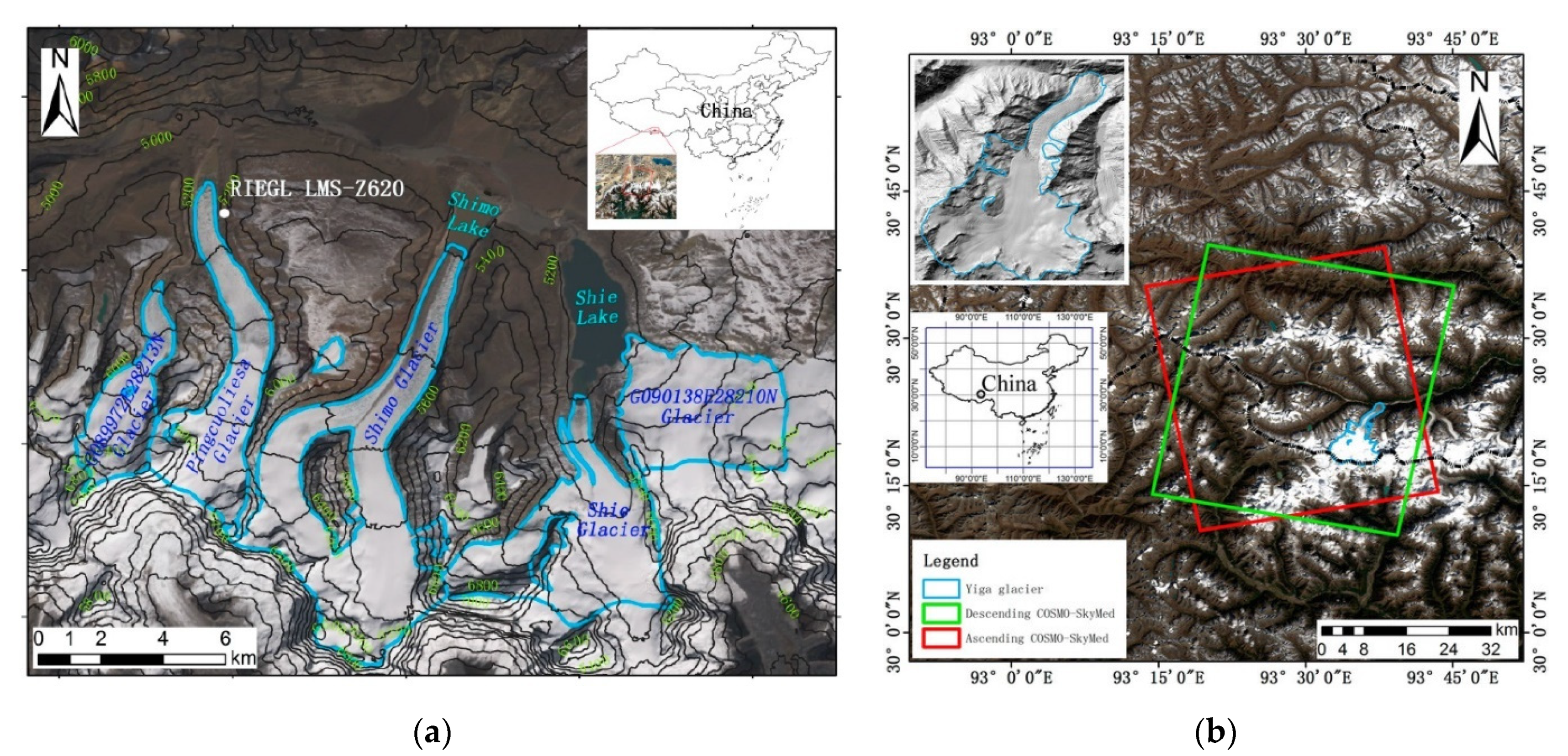
2.1. Landslide and Ice Movement Identification and Monitoring near Typical Glacier Lakes
2.2. Monitoring Land Surface Displacement Geohazards Using Multi-Temporal SAR Techniques
2.3. Spatio-Temporal Landslide Identification and Activity Assessment for Hazard and Risk Investigations
2.4. Collaborative Monitoring of Multiple Geohazards with Multi-Source Remote Sensing Data
3. The Project’s Outputs
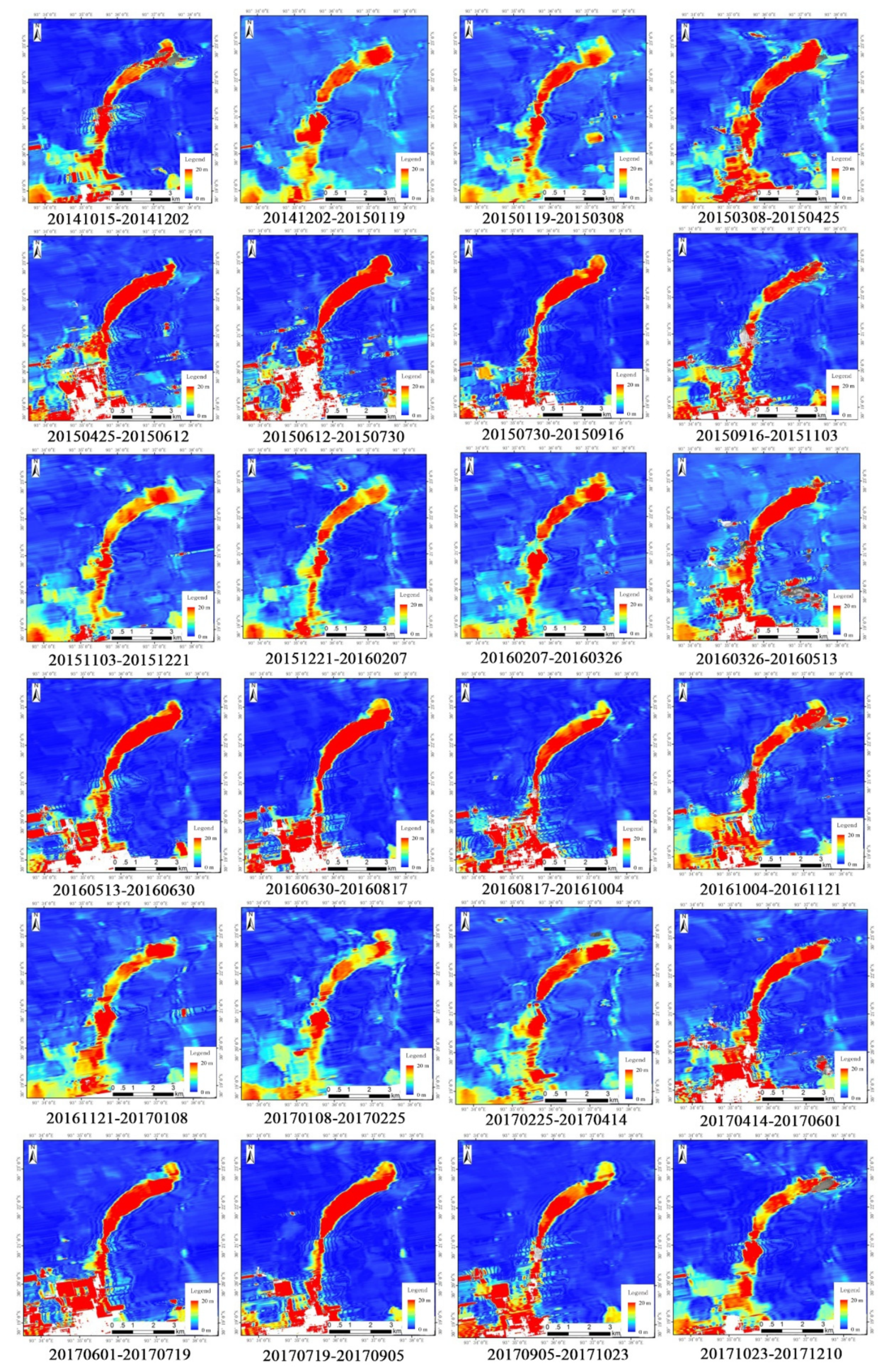
3.1. Landslide and Ice Movement Identification and Monitoring near Typical Glacier Lake
3.2. Monitoring Land Surface Displacement Geohazards Using Multi-Temporal SAR Techniques
3.3. Spatio-Temporal Landslide Identification and Activity Assessment for Hazard and Risk Investigations
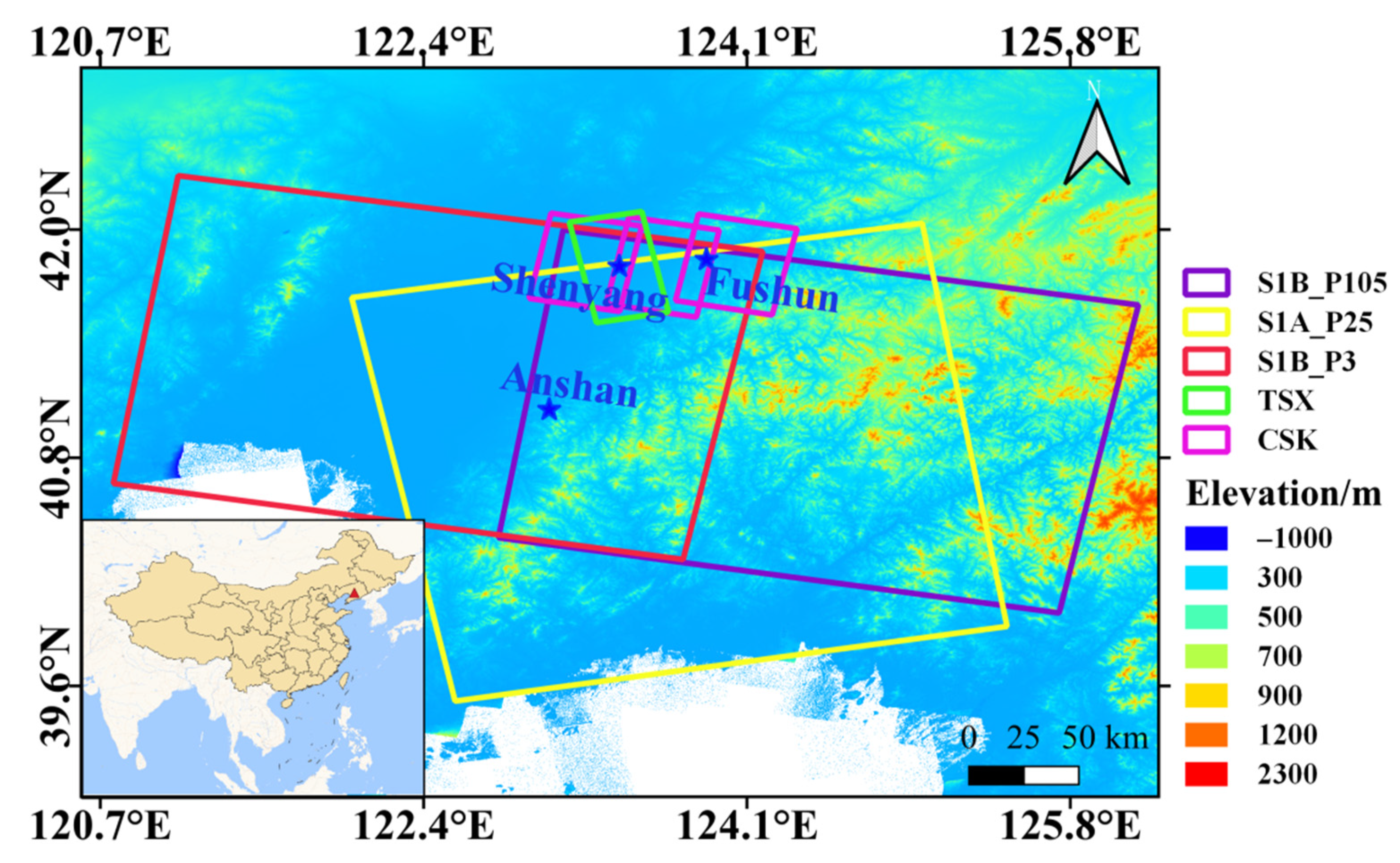
3.4. Collaborative Monitoring of Different Geohazards with Multi-Source Remote Sensing Data
3.4.1. Anshan
3.4.2. Fushun
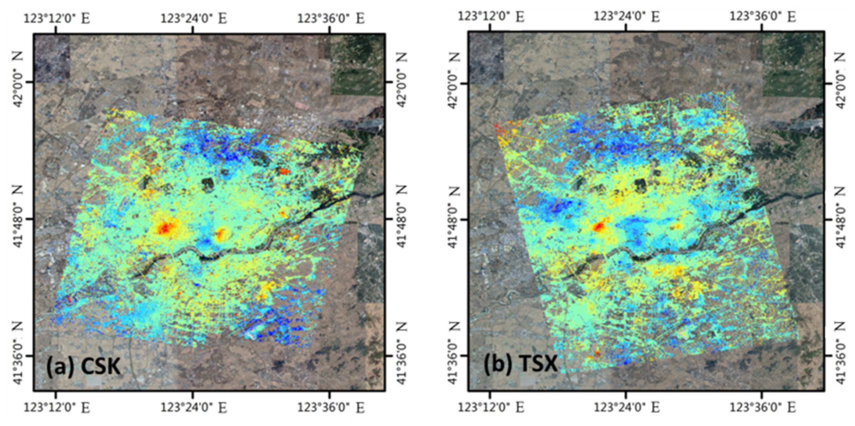
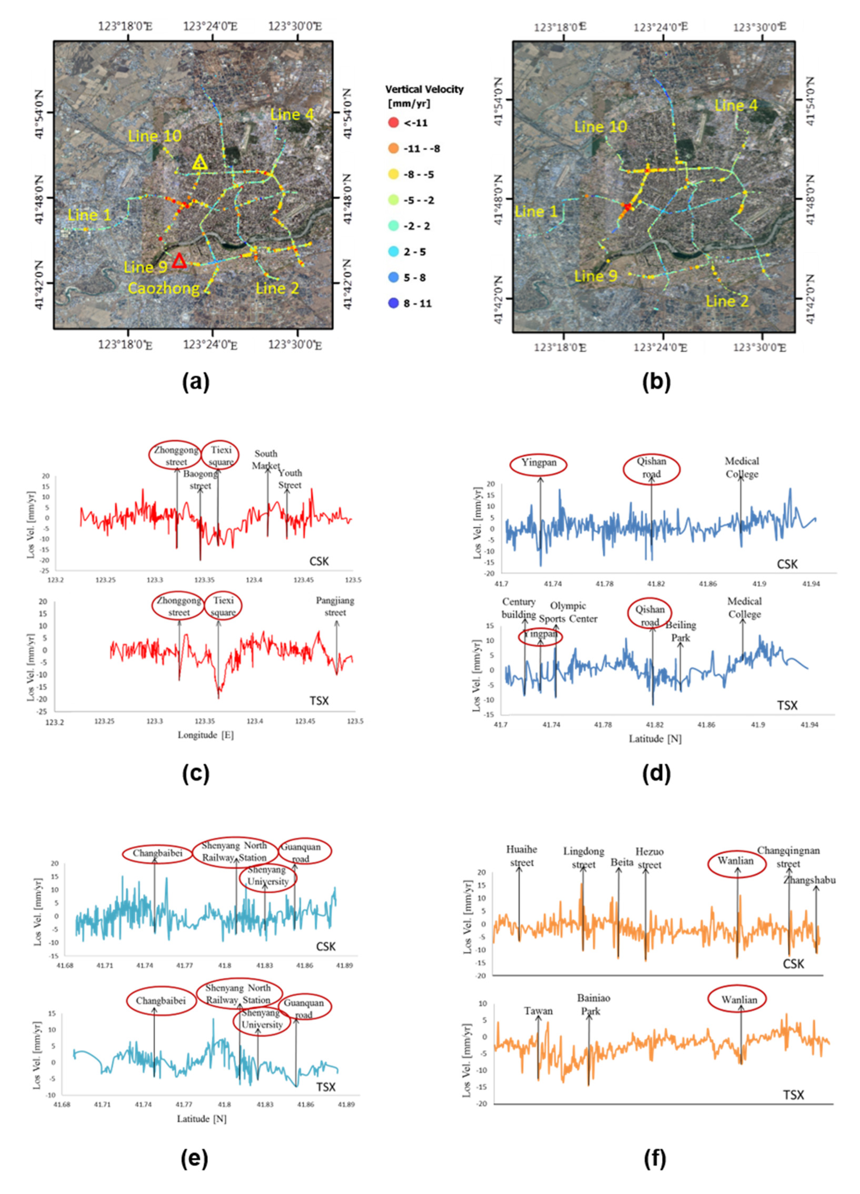
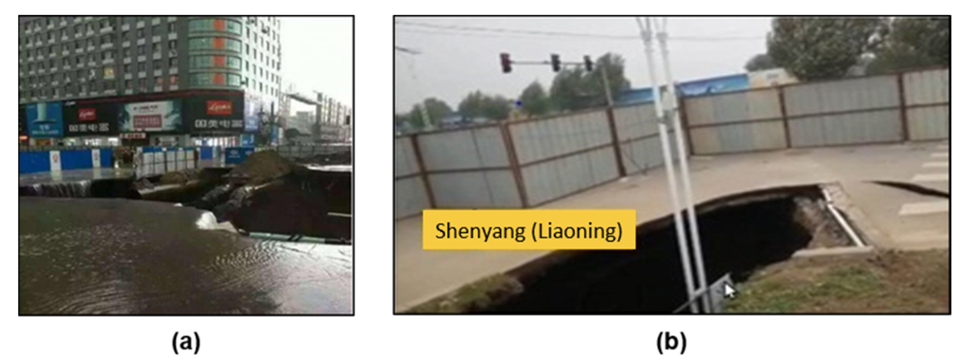
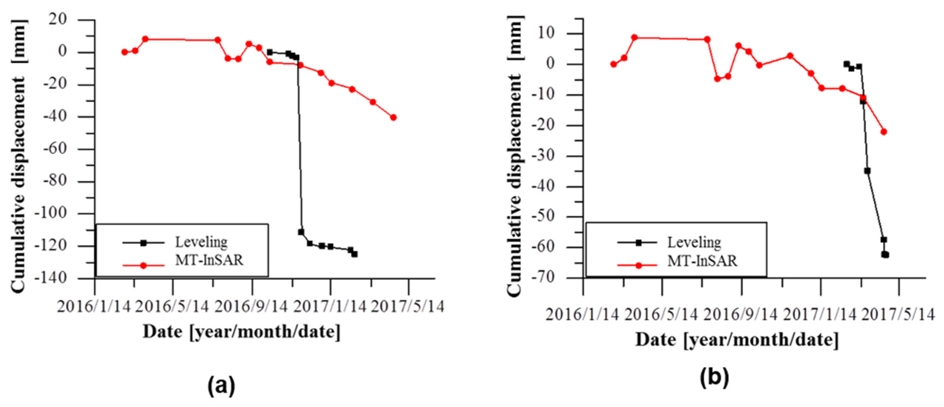
3.4.3. Shenyang
4. Discussion and Conclusions
5. Future Work
Author Contributions
Funding
Institutional Review Board Statement
Informed Consent Statement
Data Availability Statement
Acknowledgments
Conflicts of Interest
References
- Yue, H.; Liu, G.; Guo, H.; Li, X.; Kang, Z.; Wang, R.; Zhong, X. Coal mining induced land subsidence monitoring using multiband spaceborne differential interferometric synthetic aperture radar data. J. Appl. Remote. Sens. 2011, 5, 053518. [Google Scholar] [CrossRef]
- Kampes, B.; Hanssen, F.; Swart, R. Deformation Monitoring with Radar Interferometry, Analysis of Permanent Scatterers in Tianjin, China 2001, VMSG Symposium, Utrecht, The Netherlands. 19 November 2001. Available online: http://doris.tudelft.nl/Literature/kampes01a.gif (accessed on 19 October 2021).
- Liao, M.; Tang, J.; Wang, T.; Balz, T.; Zhang, L. Landslide monitoring with high-resolution SAR data in the Three Gorges region. Sci. China Earth Sci. 2012, 55, 590–601. [Google Scholar] [CrossRef]
- Liu, G.; Guo, H.; Perski, Z.; Fan, J.; Bai, S.; Yan, S.; Song, R. Monitoring the slope movement of the Shuping landslide in the Three Gorges Reservoir of China, using X-band time series SAR interferometry. Adv. Space Res. 2016, 57, 2487–2495. [Google Scholar] [CrossRef]
- Fan, H.; Deng, K.; Zhu, C.; Xue, J. Monitoring land subsidence by PS-DInSAR and SBAS methods in Tianjin City. In Proceedings of the International Symposium on Lidar and Radar Mapping 2011, Nanjing, China, 26–29 May 2011; Technologies and Applications. Li, J., Ed.; SPIE: Bellingham, WA, USA, 2011; Volume 8286, pp. 409–415. [Google Scholar]
- Perissin, D.; Wang, T. Time-Series InSAR Applications Over Urban Areas in China. IEEE J. Sel. Top. Appl. Earth Obs. Remote. Sens. 2011, 4, 92–100. [Google Scholar] [CrossRef]
- Liu, P.; Li, Z.; Hoey, T.; Kincal, C.; Zhang, J.; Zeng, Q.; Muller, J.-P. Using advanced InSAR time series techniques to monitor landslide movements in Badong of the Three Gorges region, China. Int. J. Appl. Earth Obs. Geoinf. 2013, 21, 253–264. [Google Scholar] [CrossRef]
- Gili, J.A.; Corominas, J.; Rius, J. Using Global Positioning System techniques in landslide monitoring. Eng. Geol. 2000, 55, 167–192. [Google Scholar] [CrossRef]
- Calcaterra, S.; Cesi, C.; Di Maio, C.; Gambino, P.; Merli, K.; Vallario, M.; Vassallo, R. Surface displacements of two landslides evaluated by GPS and inclinometer systems: A case study in Southern Apennines, Italy. Nat. Hazards 2012, 61, 257–266. [Google Scholar] [CrossRef]
- Nakagawa, H.; Murakami, M.; Fujiwara, S.; Tobita, M. Land subsidence of the northern Kanto plains caused by ground water extraction detected by JERS-1 SAR interferometry. In Proceedings of the IEEE 2000 International Geoscience and Remote Sensing Symposium. Taking the Pulse of the Planet: The Role of Remote Sensing in Managing the Environment. Proceedings (Cat. No.00CH37120), Honolulu, HI, USA, 24–28 July 2000; Volume 5, pp. 2233–2235. [Google Scholar]
- Khan, S.A.; Liu, L.; Wahr, J.; Howat, I.; Joughin, I.; van Dam, T.; Fleming, K. GPS measurements of crustal uplift near Jakobshavn Isbræ due to glacial ice mass loss. J. Geophys. Res: Solid Earth 2010, 115, B09405. [Google Scholar] [CrossRef] [Green Version]
- Ferretti, A.; Prati, C.; Rocca, F. Permanent scatterers in SAR interferometry. IEEE Trans. Geosci. Remote. Sens. 2001, 39, 8–20. [Google Scholar] [CrossRef]
- Adam, N.; Kampes, B.; Eineder, M. Development of a scientific permanent scatterer system: Modifications for mixed ERS/ENVISAT time series. In Proceedings of the Envisat Symposium 2004, Salzburg, Austria, 6–10 September 2004. [Google Scholar]
- Hilley, G.E.; Bürgmann, R.; Ferretti, A.; Novali, F.; Rocca, F. Dynamics of slow-moving landslides from permanent scatterer analysis. Science 2004, 304, 1952–1955. [Google Scholar] [CrossRef] [PubMed] [Green Version]
- Wasowski, J.; Bovenga, F. Investigating landslides and unstable slopes with satellite Multi Temporal Interferometry: Current issues and future perspectives. Eng. Geol. 2014, 174, 103–138. [Google Scholar] [CrossRef]
- Ferretti, A.; Prati, C.; Rocca, F. Analysis of permanent scatterers in SAR interferometry. In Proceedings of the IEEE 2000 International Geoscience and Remote Sensing Symposium. Taking the Pulse of the Planet: The Role of Remote Sensing in Managing the Environment. Proceedings (Cat. No.00CH37120), Honolulu, HI, USA, 24–28 July 2000; Volume 2, pp. 761–763. [Google Scholar]
- De Luca, C.; Bonano, M.; Casu, F.; Fusco, A.; Lanari, R.; Manunta, M.; Manzo, M.; Pepe, A.; Zinno, I. Automatic and systematic Sentinel-1 SBAS-DInSAR processing chain for deformation time-series generation. Procedia Comput. Sci. 2016, 100, 1176–1180. [Google Scholar] [CrossRef] [Green Version]
- Ferretti, A.; Fumagalli, A.; Novali, F.; Prati, C.; Rocca, F.; Rucci, A. A new algorithm for processing interferometric data-stacks: SqueeSAR. IEEE Trans. Geosci. Remote. Sens. 2011, 49, 3460–3470. [Google Scholar] [CrossRef]
- Zhao, C.; Lu, Z.; Zhang, Q.; de La Fuente, J. Large-area landslide detection and monitoring with ALOS/PALSAR imagery data over Northern California and Southern Oregon, USA. Remote. Sens. Environ. 2012, 124, 348–359. [Google Scholar] [CrossRef]
- Yan, S.; Guo, H.; Liu, G.; Ruan, Z. Mountain glacier displacement estimation using a DEM-assisted offset tracking method with ALOS/PALSAR data. Remote. Sens. Lett. 2013, 4, 494–503. [Google Scholar] [CrossRef]
- Yan, S.; Liu, G.; Deng, K.; Wang, Y.; Zhang, S.; Zhao, F. Large deformation monitoring over a coal mining region using pixel-tracking method with high-resolution Radarsat-2 imagery. Remote. Sens. Lett. 2016, 7, 219–228. [Google Scholar] [CrossRef]
- Guo, H.; Liu, G.; Liao, J.; Li, X.; Zhang, L.; Shen, G.; Fu, W.; Sun, Z. Study of RADARSAT-2 synthetic aperture radar data for observing sensitive factors of global environmental change. J. Appl. Remote. Sens. 2014, 8, 084593. [Google Scholar] [CrossRef] [Green Version]
- Liu, G.; Guo, H.; Yue, H.; Perski, Z.; Yan, S.; Song, R.; Fan, J.; Ruan, Z. Modified four-pass differential SAR interferometry for estimating mountain glacier surface velocity fields. Remote. Sens. Lett. 2016, 7, 1–10. [Google Scholar] [CrossRef] [Green Version]
- Novellino, A.; Cigna, F.; Sowter, A.; Ramondini, M.; Calcaterra, D. Exploitation of the Intermittent SBAS (ISBAS) algorithm with COSMO-SkyMed data for landslide inventory mapping in north-western Sicily, Italy. Geomorphology 2017, 280, 153–166. [Google Scholar] [CrossRef]
- Dong, J.; Zhang, L.; Tang, M.; Liao, M.; Xu, Q.; Gong, J.; Ao, M. Mapping landslide surface displacements with time series SAR interferometry by combining persistent and distributed scatterers: A case study of Jiaju landslide in Danba, China. Remote. Sens. Environ. 2018, 205, 180–198. [Google Scholar] [CrossRef]
- Zhang, Y.; Meng, X.; Jordan, C.; Novellino, A.; Dijkstra, T.; Chen, G. Investigating slow-moving landslides in the Zhouqu region of China using InSAR time series. Landslides 2018, 15, 1299–1315. [Google Scholar] [CrossRef]
- Joughin, I. Ice-sheet velocity mapping: A combined interferometric and speckle-tracking approach. Ann. Glaciol. 2002, 34, 195–201. [Google Scholar] [CrossRef] [Green Version]
- Xie, Z.; Liu, C. Introduction to glaciology; Shanghai Popular Science Press: Shanghai, China, 2010. [Google Scholar]
- Bolch, T.; Buchroithner, M.F.; Peters, J.; Baessler, M.; Bajracharya, S. Identification of glacier motion and potentially dangerous glacial lakes in the Mt. Everest region/Nepal using spaceborne imagery. Nat. Hazards Earth Syst. Sci. 2008, 8, 1329–1340. [Google Scholar] [CrossRef] [Green Version]
- Herman, F.; Anderson, B.; Leprince, S. Mountain glacier velocity variation during a retreat/advance cycle quantified using sub-pixel analysis of ASTER images. J. Glaciol. 2011, 57, 197–207. [Google Scholar] [CrossRef] [Green Version]
- Guerriero, L.; Di Martire, D.; Calcaterra, D.; Francioni, M. Digital image correlation of Google Earth images for Earth’s surface displacement estimation. Remote. Sens. 2020, 12, 3518. [Google Scholar] [CrossRef]
- Yao, X.; Liu, S.; Sun, M.; Zhang, X. Study on the glacial lake outburst flood events in Tibet since the 20th century. Ziran Ziyuan Xuebao 2014, 29, 1377–1390. [Google Scholar]
- Mouginot, J.; Scheuchl, B.; Rignot, E. Mapping of ice motion in Antarctica using synthetic-aperture radar data. Remote. Sens. 2012, 4, 2753–2767. [Google Scholar] [CrossRef] [Green Version]
- Mouginot, J.; Rignot, E. Ice motion of the Patagonian icefields of South America: 1984–2014. Geophys. Res. Lett. 2015, 42, 1441–1449. [Google Scholar] [CrossRef] [Green Version]
- Gudmundsson, S.; Gudmundsson, M.T.; Björnsson, H.; Sigmundsson, F.; Rott, H.; Carstensen, J.M. Three-dimensional glacier surface motion maps at the Gjálp eruption site, Iceland, inferred from combining InSAR and other ice-displacement data. Ann. Glaciol. 2002, 34, 315–322. [Google Scholar] [CrossRef] [Green Version]
- Short, N.; Gray, A. Glacier dynamics in the Canadian High Arctic from RADARSAT-1 speckle tracking. Can. J. Remote. Sens. 2005, 31, 225–239. [Google Scholar] [CrossRef]
- Schneevoigt, N.J.; Sund, M.; Bogren, W.; Kääb, A.; Weydahl, D.J. Glacier displacement on Comfortlessbreen, Svalbard, using 2-pass differential SAR interferometry (DInSAR) with a digital elevation model. Polar Rec. 2012, 48, 17–25. [Google Scholar] [CrossRef]
- Joughin, I.; Kwok, R.; Fahnestock, M. Estimation of ice-sheet motion using satellite radar interferometry: Method and error analysis with application to Humboldt Glacier, Greenland. J. Glaciol. 1996, 42, 564–575. [Google Scholar] [CrossRef] [Green Version]
- Gray, A.L.; Mattar, K.E.; Vachon, P.W.; Bindschadler, R.; Jezek, K.C.; Forster, R.; Crawford, J.P. InSAR results from the RADARSAT Antarctic Mapping Mission data: Estimation of glacier motion using a simple registration procedure. In Proceedings of the 1998 IEEE International Geoscience and Remote Sensing; IEEE, Seattle, WA, USA, 6–10 July 1998; Volume 3, pp. 1638–1640. [Google Scholar]
- Bechor, N.B.; Zebker, H.A. Measuring two-dimensional movements using a single InSAR pair. Geophys. Res. Lett. 2006, 33. [Google Scholar] [CrossRef] [Green Version]
- Covello, F.; Battazza, F.; Coletta, A.; Lopinto, E.; Fiorentino, C.; Pietranera, L.; Valentini, G.; Zoffoli, S. COSMO-SkyMed an existing opportunity for observing the Earth. J. Geodyn. 2010, 49, 171–180. [Google Scholar] [CrossRef] [Green Version]
- Carturan, L.; Blasone, G.; Calligaro, S.; Carton, A.; Cazorzi, F.; Dalla Fontana, G.; Moro, D. High-resolution monitoring of current rapid transformations on glacial and periglacial environments. Int. Arch. Photogramm. Remote. Sens. Spat. Inf. Sci. 2013, 5, W3. [Google Scholar] [CrossRef] [Green Version]
- Telling, J.; Lyda, A.; Hartzell, P.; Glennie, C. Review of Earth science research using terrestrial laser scanning. Earth Sci. Rev. 2017, 169, 35–68. [Google Scholar] [CrossRef] [Green Version]
- Liu, Y.; Qu, Y.; Lei, Z.; Wang, W. Multi-sector reduction potential of embodied carbon emissions in China: A case study of Liaoning province. Environ. Dev. Sustain. 2020, 22, 5585–5602. [Google Scholar] [CrossRef]
- Wang, J.; Zhao, F.; Yang, J.; Li, X. Mining site reclamation planning based on land suitability analysis and ecosystem services evaluation: A case study in Liaoning province, China. Sustainability 2017, 9, 890. [Google Scholar] [CrossRef] [Green Version]
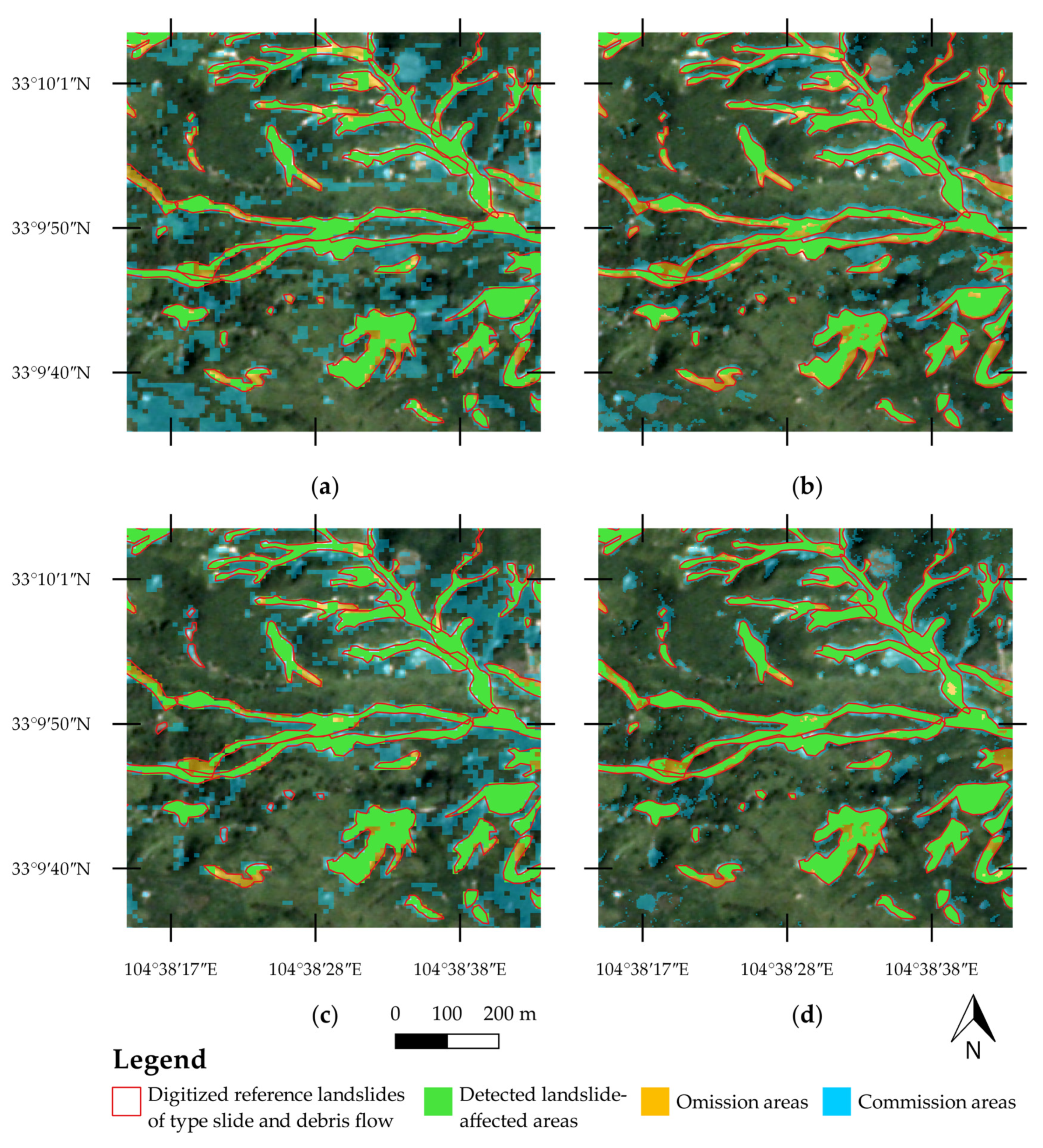
- Qin, Y.; Lu, P.; Li, Z. LANDSLIDE INVENTORY MAPPING FROM BITEMPORAL 10 m SENTINEL-2 IMAGES USING CHANGE DETECTION BASED MARKOV RANDOM FIELD. Int. Arch. Photogramm. Remote. Sens. Spat. Inf. Sci. 2018, Volume XLII-3, 42. [Google Scholar] [CrossRef] [Green Version]
- Guzzetti, F.; Mondini, A.C.; Cardinali, M.; Fiorucci, F.; Santangelo, M.; Chang, K.-T. Landslide inventory maps: New tools for an old problem. Earth Sci. Rev. 2012, 112, 42–66. [Google Scholar] [CrossRef] [Green Version]
- Van Westen, C.J.; Castellanos, E.; Kuriakose, S.L. Spatial data for landslide susceptibility, hazard, and vulnerability assessment: An overview. Eng. Geol. 2008, 102, 112–131. [Google Scholar] [CrossRef]
- Jaboyedoff, M.; Abellán, A.; Carrea, D.; Derron, M.-H.; Matasci, B.; Michoud, C. Mapping and monitoring of landslides using LiDAR. In Natural Hazards; CRC Press: Boca Raton, FL, USA, 2018; pp. 397–420. ISBN 1-315-16684-4. [Google Scholar]
- Scaioni, M.; Longoni, L.; Melillo, V.; Papini, M. Remote sensing for landslide investigations: An overview of recent achievements and perspectives. Remote. Sens. 2014, 6, 9600–9652. [Google Scholar] [CrossRef] [Green Version]
- Ramos-Bernal, R.N.; Vázquez-Jiménez, R.; Romero-Calcerrada, R.; Arrogante-Funes, P.; Novillo, C.J. Evaluation of unsupervised change detection methods applied to landslide inventory mapping using ASTER imagery. Remote. Sens. 2018, 10, 1987. [Google Scholar] [CrossRef] [Green Version]
- Mondini, A.C.; Chang, K.-T.; Yin, H.-Y. Combining multiple change detection indices for mapping landslides triggered by typhoons. Geomorphology 2011, 134, 440–451. [Google Scholar] [CrossRef]
- Lu, P.; Qin, Y.; Li, Z.; Mondini, A.C.; Casagli, N. Landslide mapping from multi-sensor data through improved change detection-based Markov random field. Remote. Sens. Environ. 2019, 231, 111235. [Google Scholar] [CrossRef]
- Amatya, P.; Kirschbaum, D.; Stanley, T. Use of very high-resolution optical data for landslide mapping and susceptibility analysis along the Karnali highway, Nepal. Remote. Sens. 2019, 11, 2284. [Google Scholar] [CrossRef] [Green Version]
- Hölbling, D.; Eisank, C.; Albrecht, F.; Vecchiotti, F.; Friedl, B.; Weinke, E.; Kociu, A. Comparing manual and semi-automated landslide mapping based on optical satellite images from different sensors. Geosciences 2017, 7, 37. [Google Scholar] [CrossRef] [Green Version]
- Planet Application Program Interface: In Space for Life on Earth. Available online: https://api.planet.com (accessed on 1 September 2021).
- Fan, J.; Wang, Q.; Liu, G.; Zhang, L.; Guo, Z.; Tong, L.; Peng, J.; Yuan, W.; Zhou, W.; Yan, J.; et al. Monitoring and analyzing mountain glacier surface movement using SAR data and a terrestrial laser scanner: A case study of the Himalayas North Slope Glacier Area. Remote. Sens. 2019, 11, 625. [Google Scholar] [CrossRef] [Green Version]
- Strozzi, T.; Luckman, A.; Murray, T.; Wegmuller, U.; Werner, C.L. Glacier motion estimation using SAR offset-tracking procedures. IEEE Trans. Geosci. Remote. Sens. 2002, 40, 2384–2391. [Google Scholar] [CrossRef] [Green Version]
- Jiang, Z.; Liu, S.; Peters, J.; Lin, J.; Long, S.; Han, Y.; Wang, X. Analyzing Yengisogat Glacier surface velocities with ALOS PALSAR data feature tracking, Karakoram, China. Environ. Earth Sci. 2012, 67, 1033–1043. [Google Scholar] [CrossRef]
- Schellenberger, T.; Dunse, T.; Kääb, A.; Kohler, J.; Reijmer, C. Surface speed and frontal ablation of Kronebreen and Kongsbreen, NW Svalbard, from SAR offset tracking. Cryosphere 2015, 9, 2339–2355. [Google Scholar] [CrossRef] [Green Version]
- Yan, S.; Ruan, Z.; Liu, G.; Deng, K.; Lv, M.; Perski, Z. Deriving ice motion patterns in mountainous regions by integrating the intensity-based pixel-tracking and phase-based D-InSAR and MAI approaches: A case study of the Chongce glacier. Remote. Sens. 2016, 8, 611. [Google Scholar] [CrossRef] [Green Version]
- Crosetto, M.; Monserrat, O.; Cuevas-González, M.; Devanthéry, N.; Crippa, B. Persistent scatterer interferometry: A review. ISPRS J. Photogramm. Remote. Sens. 2016, 115, 78–89. [Google Scholar] [CrossRef] [Green Version]
- Rosen, P.A.; Hensley, S.; Joughin, I.R.; Li, F.K.; Madsen, S.N.; Rodriguez, E.; Goldstein, R.M. Synthetic aperture radar interferometry. Proc. IEEE 2000, 88, 333–382. [Google Scholar] [CrossRef]
- Hooper, A.; Segall, P.; Zebker, H. Persistent scatterer interferometric synthetic aperture radar for crustal deformation analysis. J. Geophys. Res. 2007, 112, 1–21. [Google Scholar]
- Hooper, A. A multi-temporal InSAR method incorporating both persistent scatterer and small baseline approaches. Geophys. Res. Lett. 2008, 35, L16302. [Google Scholar] [CrossRef] [Green Version]
- Perski, Z.; Liu, G.; Wojciechowski, T.; Jinhui, F.; Wójcik, A. Monitoring the Activity of Landslides in the Coastal Zones of Reservoirs with SAR Interferometry. In Landslide Science for a Safer Geoenvironment; Springer: Berlin/Heidelberg, Germany, 2014; pp. 331–336. [Google Scholar]
- Galloway, D.L.; Hudnut, K.W.; Ingebritsen, S.; Phillips, S.P.; Peltzer, G.; Rogez, F.; Rosen, P. Detection of aquifer system compaction and land subsidence using interferometric synthetic aperture radar, Antelope Valley, Mojave Desert, California. Water Resour. Res. 1998, 34, 2573–2585. [Google Scholar] [CrossRef]
- Amelung, F.; Jonsson, S.; Zebker, H.; Segall, P. Prospects of Volcano Geodesy with ERS Radar Interferometry. Eur. Space Agency (Special Publication) ESA SP 2000, 177–185. [Google Scholar]
- Qi, W.; Wei, M.; Yang, W.; Xu, C.; Ma, C. Automatic mapping of landslides by the ResU-net. Remote. Sens. 2020, 12, 2487. [Google Scholar] [CrossRef]
- Yu, B.; Chen, F.; Muhammad, S. Analysis of satellite-derived landslide at Central Nepal from 2011 to 2016. Environ. Earth Sci. 2018, 77, 1–12. [Google Scholar] [CrossRef]
- Behling, R.; Roessner, S.; Golovko, D.; Kleinschmit, B. Derivation of long-term spatiotemporal landslide activity—A multi-sensor time series approach. Remote. Sens. Environ. 2016, 186, 88–104. [Google Scholar] [CrossRef]
- Hengl, T. Finding the right pixel size. Comput. Geosci. 2006, 32, 1283–1298. [Google Scholar] [CrossRef]
- Steger, S.; Schmaltz, E.; Glade, T. The (f) utility to account for pre-failure topography in data-driven landslide susceptibility modelling. Geomorphology 2020, 354, 107041. [Google Scholar] [CrossRef]
- Fawcett, T. An introduction to ROC analysis. Pattern Recognit. Lett. 2006, 27, 861–874. [Google Scholar] [CrossRef]
- Hosmer Jr, D.W.; Lemeshow, S.; Sturdivant, R.X. Applied logistic regression; John Wiley & Sons: Hoboken, NJ, USA, 2013; Volume 398, ISBN 0-470-58247-2. [Google Scholar]
- Bovolo, F.; Marchesi, S.; Bruzzone, L. A framework for automatic and unsupervised detection of multiple changes in multitemporal images. IEEE Trans. Geosci. Remote. Sens. 2011, 50, 2196–2212. [Google Scholar] [CrossRef]
- Dempster, A.P.; Laird, N.M.; Rubin, D.B. Maximum likelihood from incomplete data via the EM algorithm. J. R. Stat. Soc. Ser. B 1977, 39, 1–22. [Google Scholar]
- Bazi, Y.; Bruzzone, L.; Melgani, F. Image thresholding based on the EM algorithm and the generalized Gaussian distribution. Pattern Recognit 2007, 40, 619–634. [Google Scholar] [CrossRef]
- Bruzzone, L.; Prieto, D.F. Automatic analysis of the difference image for unsupervised change detection. IEEE Trans. Geosci. Remote. Sens. 2000, 38, 1171–1182. [Google Scholar] [CrossRef] [Green Version]
- Guo, W.; Liu, S.; Yao, X.; Xu, J.; Shangguan, D.; Wu, L.; Zhao, J.; Liu, Q.; Jiang, Z.; Wei, J. The Second Glacier Inventory Dataset of China; (Version 1.0): Cold and Arid Regions Science Data Center at Lanzhou: Lanzhou, China, 2014; p. 20. [Google Scholar]
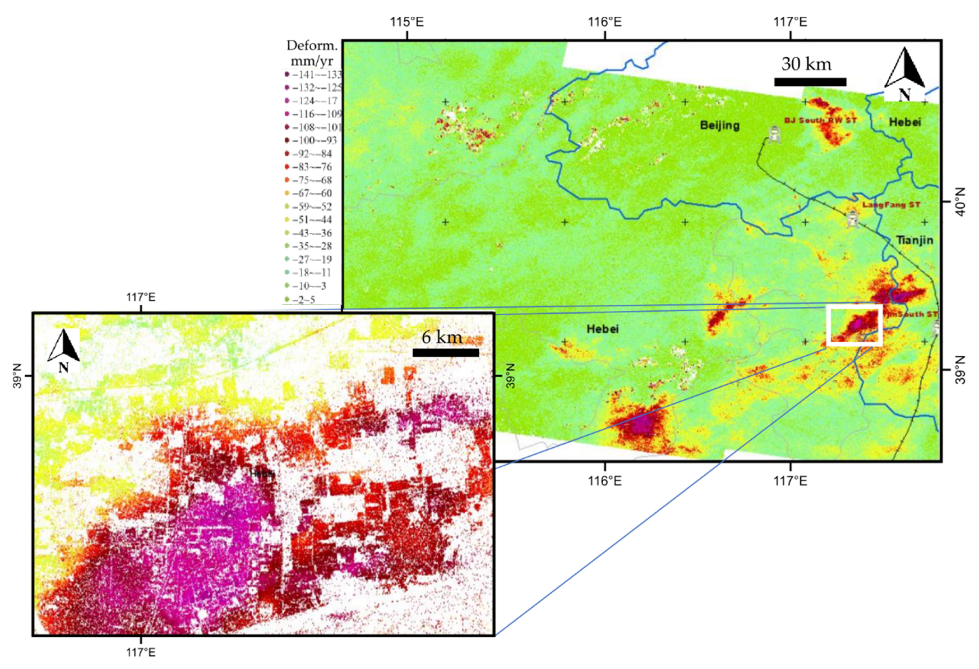
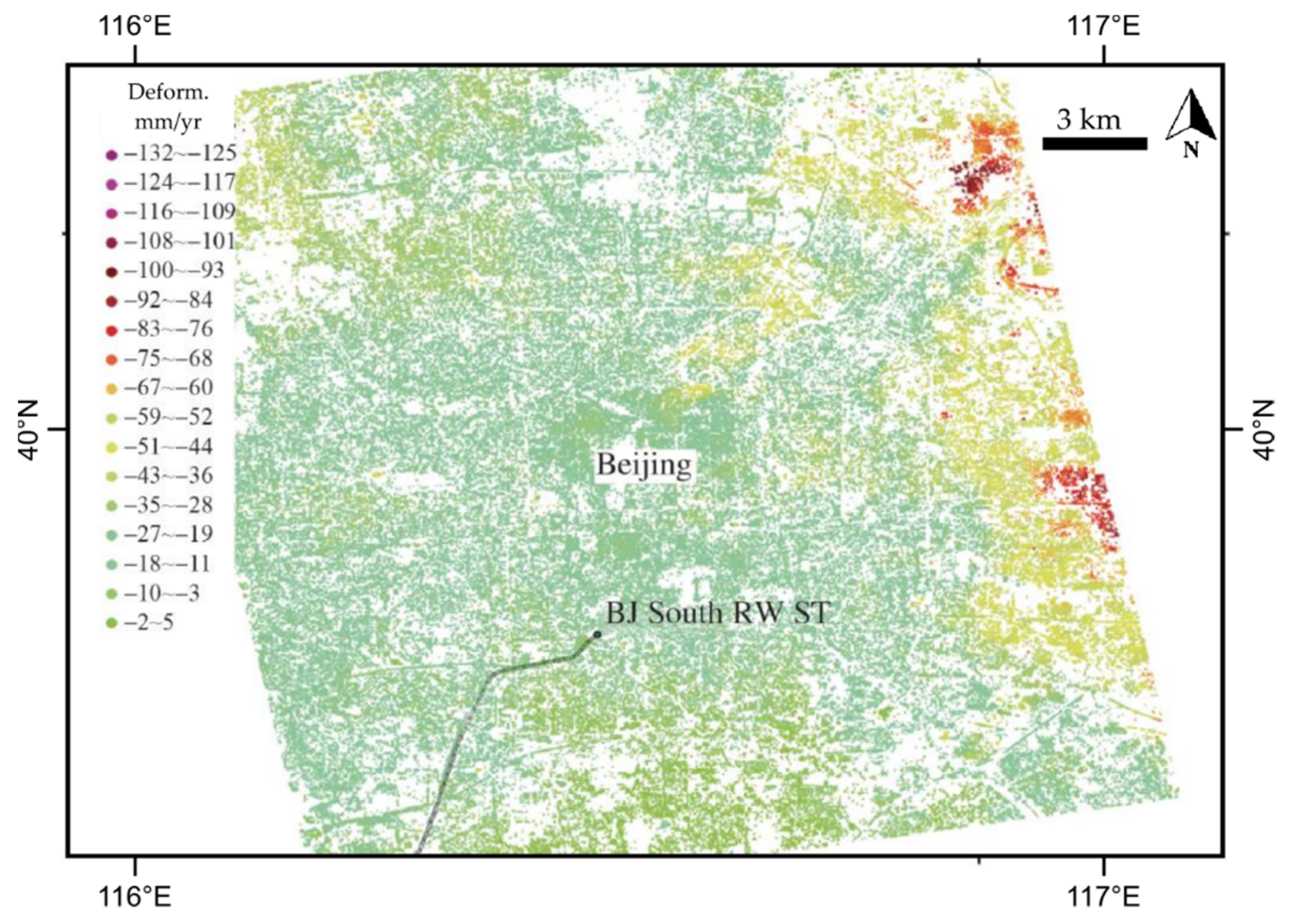
- Ng, A.H.-M.; Ge, L.; Li, X.; Zhang, K. Monitoring ground deformation in Beijing, China with persistent scatterer SAR interferometry. J. Geod. 2012, 86, 375–392. [Google Scholar] [CrossRef]
- Guo, J.; Hu, J.; Li, B.; Zhou, L.; Wang, W. Land subsidence in Tianjin for 2015 to 2016 revealed by the analysis of Sentinel-1A with SBAS-InSAR. J. Appl. Remote. Sens. 2017, 11, 026024. [Google Scholar] [CrossRef]
- Guang, L.; Zbigniew, P.; Stefano, S.; Benni, T.; Lixin, W.; Jinghui, F.; Shibiao, B.; Lianhuan, W.; Shiyong, Y.; Rui, S. Land Surface Displacement Geohazards Monitoring Using Multi-temporal InSAR Techniques. J. Surv. Eng. 2021, 4, 77–87. [Google Scholar]
- Wang, X.; Liu, Q.; Jiang, L.; Liu, S.; Ding, Y.; Jiang, Z. Characteristics and influence factors of glacier surface flow velocity in the Everest region, the Himalayas derived from ALOS/PALSAR images. J. Glaciol. Geocryol 2015, 37, 570–579. [Google Scholar]


| ESA Third-Party Missions | ESA | China | |||
|---|---|---|---|---|---|
| COSMO-SkyMed | 745 | Sentinel 1-A/B | 1740 | GF-3 | 12 |
| TerraSAR-X | 68 | Sentinel 2-A/B MSI | 1657 | ZY-3 | 12 |
| ALOS | 48 | ERS | 255 | ||
| PlanetScope | 2 | Envisat | 510 | ||
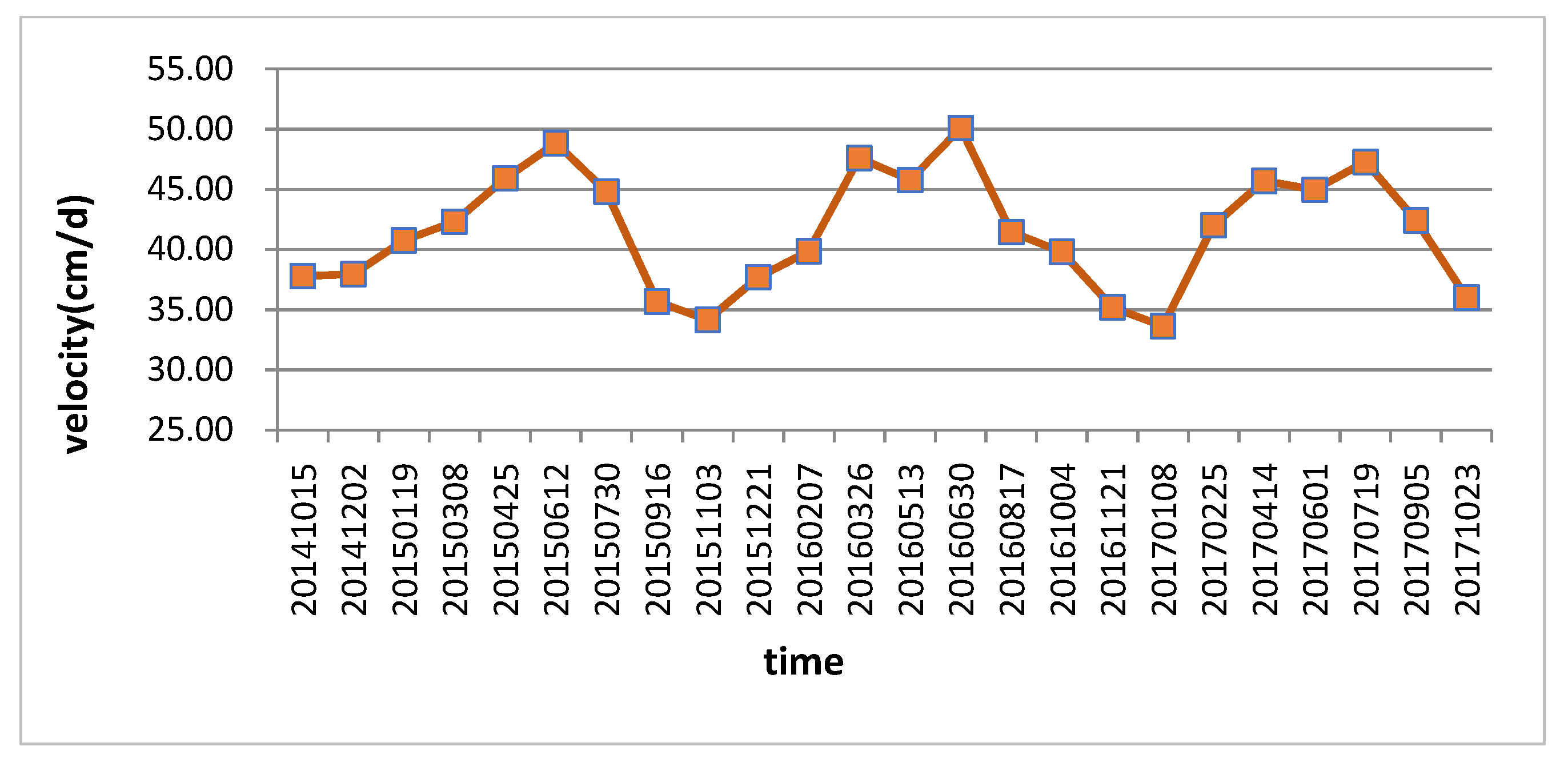
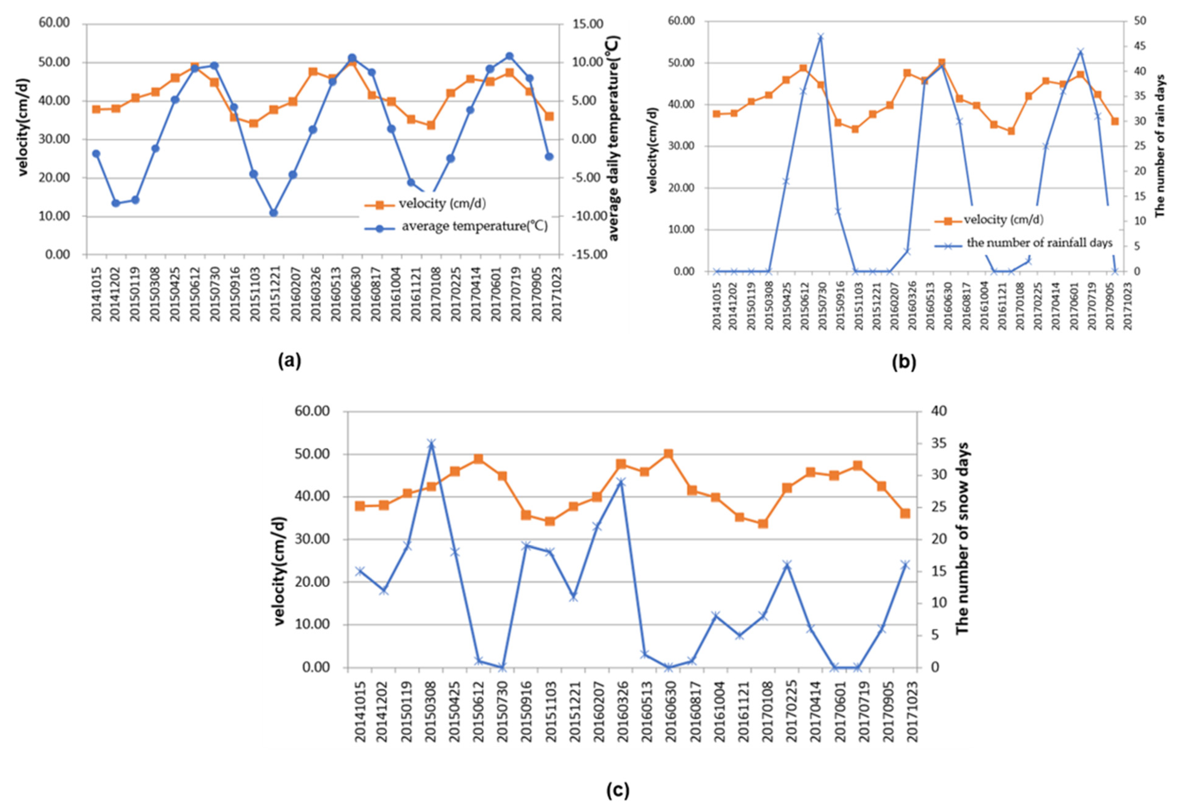
| Image Pairs | Displacement (m) | Velocity (cm/Day) |
|---|---|---|
| 20141015–20141202 | 18.15 | 37.80 |
| 20141202–20150119 | 18.22 | 37.95 |
| 20150119–20150308 | 19.57 | 40.77 |
| 20150308–20150425 | 20.30 | 42.30 |
| 20150425–20150612 | 22.04 | 45.92 |
| 20150612–20150730 | 23.44 | 48.84 |
| 20150730–20150916 | 21.51 | 44.81 |
| 20150916–20151103 | 17.13 | 35.69 |
| 20151103–20151221 | 16.39 | 34.15 |
| 20151221–20160207 | 18.09 | 37.70 |
| 20160207–20160326 | 19.13 | 39.86 |
| 20160326–20160513 | 22.85 | 47.61 |
| 20160513–20160630 | 21.97 | 45.77 |
| 20160630–20160817 | 24.05 | 50.10 |
| 20160817–20161004 | 19.89 | 41.44 |
| 20161004–20161121 | 19.11 | 39.82 |
| 20161121–20170108 | 16.89 | 35.20 |
| 20170108–20170225 | 16.14 | 33.63 |
| 20170225–20170414 | 20.17 | 42.03 |
| 20170414–20170601 | 21.93 | 45.70 |
| 20170601–20170719 | 21.58 | 44.96 |
| 20170719–20170905 | 22.69 | 47.27 |
| 20170905–20171023 | 20.37 | 42.43 |
| 20171023–20171210 | 17.28 | 36.00 |
| Sensitivity | Specificity | OA | AUROC | |||||
|---|---|---|---|---|---|---|---|---|
| Sensor | EM | GAM | EM | GAM | EM | GAM | EM | GAM |
| Sentinel-2 | 0.81 | 0.84 | 0.58 | 0.85 | 0.85 | 0.84 | 0.73 | 0.9 |
| PlanetScope | 0.73 | 0.92 | 0.81 | 0.81 | 0.81 | 0.86 | 0.83 | 0.93 |
Publisher’s Note: MDPI stays neutral with regard to jurisdictional claims in published maps and institutional affiliations. |
© 2021 by the authors. Licensee MDPI, Basel, Switzerland. This article is an open access article distributed under the terms and conditions of the Creative Commons Attribution (CC BY) license (https://creativecommons.org/licenses/by/4.0/).
Share and Cite
Sousa, J.J.; Liu, G.; Fan, J.; Perski, Z.; Steger, S.; Bai, S.; Wei, L.; Salvi, S.; Wang, Q.; Tu, J.; et al. Geohazards Monitoring and Assessment Using Multi-Source Earth Observation Techniques. Remote Sens. 2021, 13, 4269. https://doi.org/10.3390/rs13214269
Sousa JJ, Liu G, Fan J, Perski Z, Steger S, Bai S, Wei L, Salvi S, Wang Q, Tu J, et al. Geohazards Monitoring and Assessment Using Multi-Source Earth Observation Techniques. Remote Sensing. 2021; 13(21):4269. https://doi.org/10.3390/rs13214269
Chicago/Turabian StyleSousa, Joaquim J., Guang Liu, Jinghui Fan, Zbigniew Perski, Stefan Steger, Shibiao Bai, Lianhuan Wei, Stefano Salvi, Qun Wang, Jienan Tu, and et al. 2021. "Geohazards Monitoring and Assessment Using Multi-Source Earth Observation Techniques" Remote Sensing 13, no. 21: 4269. https://doi.org/10.3390/rs13214269