The Potentiality of Operational Mapping of Oil Pollution in the Mediterranean Sea near the Entrance of the Suez Canal Using Sentinel-1 SAR Data


Abstract
:1. Introduction
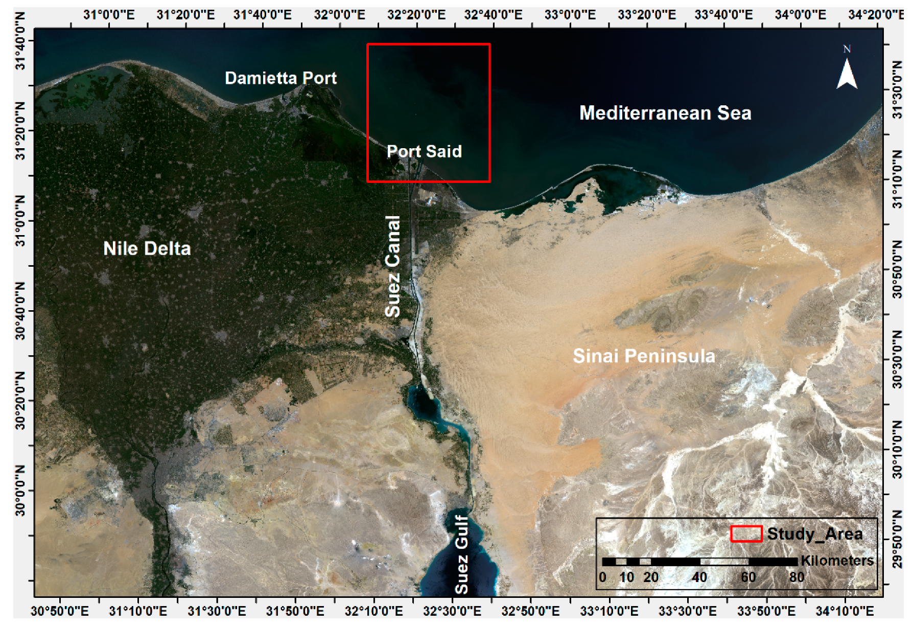
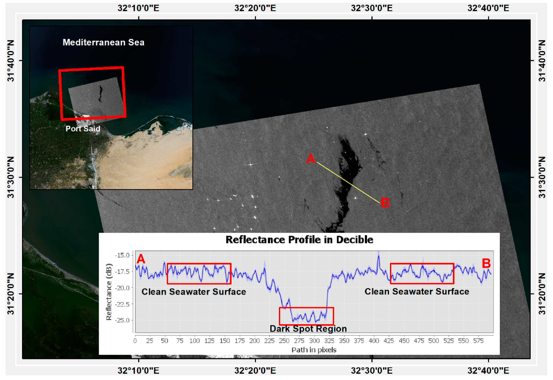
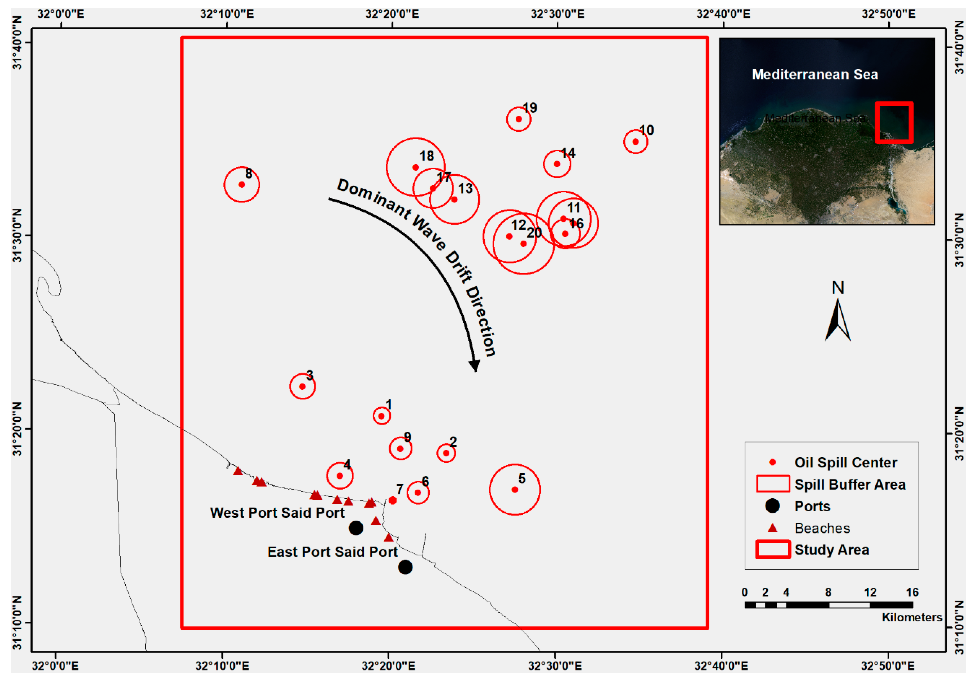
2. Area of Study
3. Materials and Methods
3.1. Data Sources
3.2. Theoretical Background
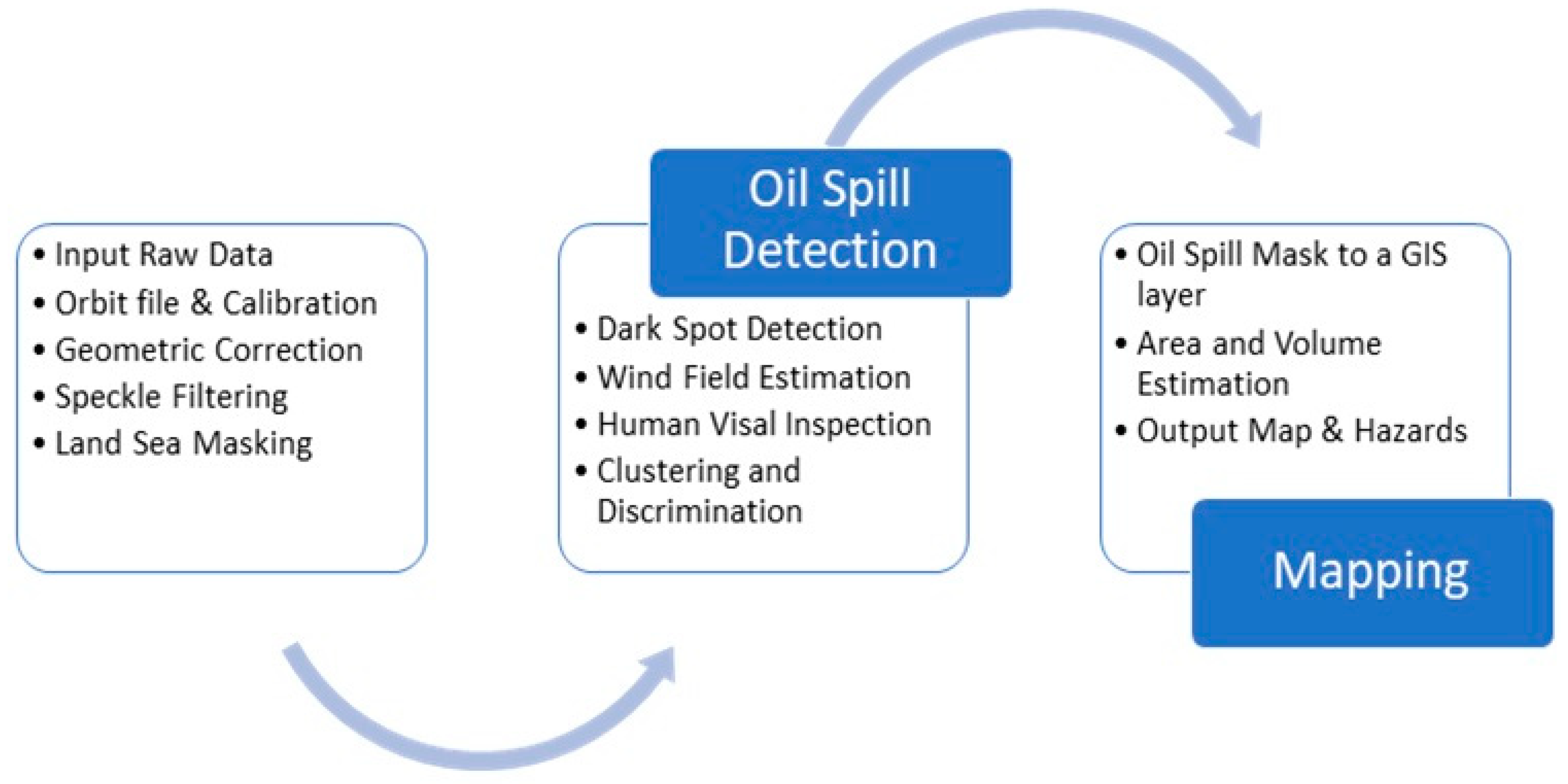
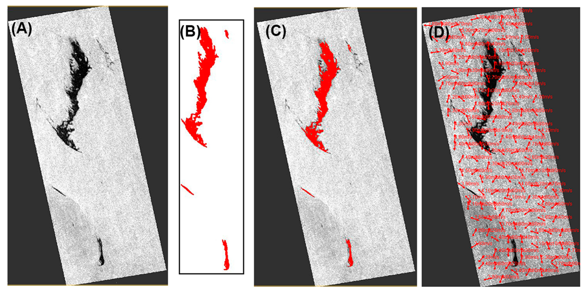
3.3. Method
- The raw images are preprocessed in multiple steps. First, improving the location accuracy of the images using the orbit file. Second, SAR calibration made to make sure that each pixel value actually represent the radar backscatter of the scene and that is important for the quantitative use of data. Then, data trimmed to the target area followed by Lee speckle filtering. Last, land-sea masking to make sure that the only available pixels for processing are the water pixels.
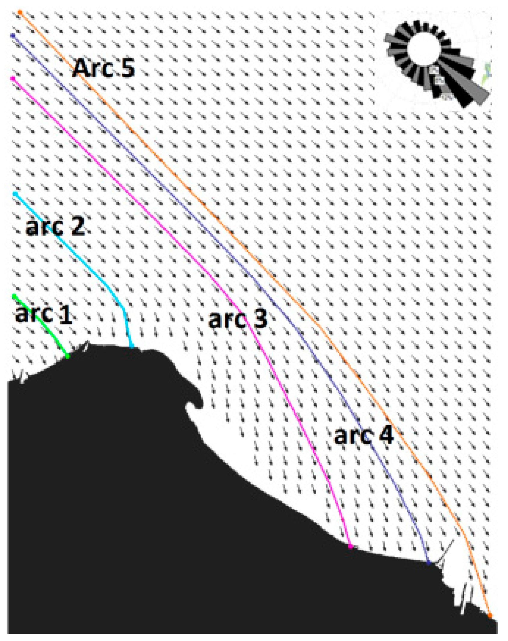
- The SAR images are processed for oil spill clustering. It is done using a dynamic window of x pixels scanning the image and looking for dark areas according to a pre-defined threshold and here it is set to be from 2.5 to 4 dB. The wind vector can be estimated from the radar backscatter in the image as when the wind blows across the ocean surface, it creates surface roughness related to the wind speed and direction. At some stages, human experience is necessary to differentiate between whether the dark spot is an oil slick or look-alike based on the spot pattern, wind field calculation, and area ancillary data.
- Finally, the clustered oil mask is converted to a GIS layer for further spatial analysis such as area calculations, volume estimation, hazard prediction, and other mapping requirements.
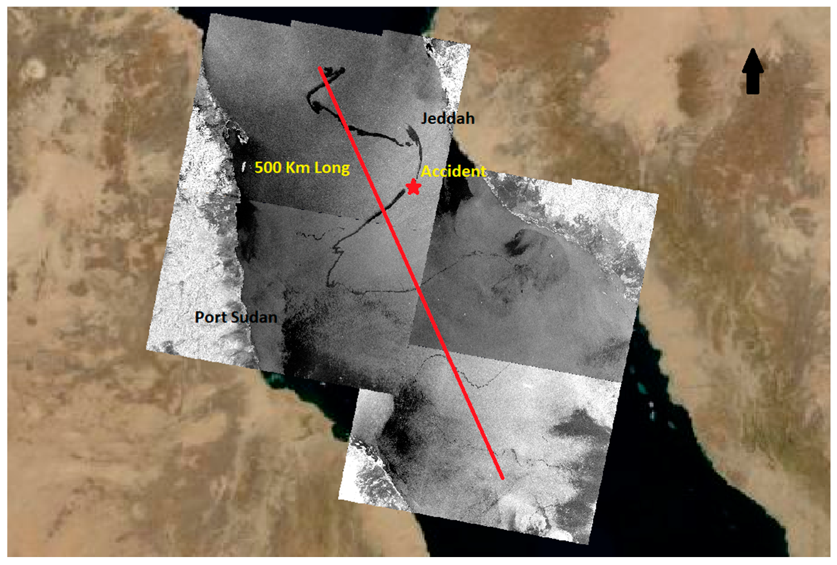
3.4. SAR Limitations
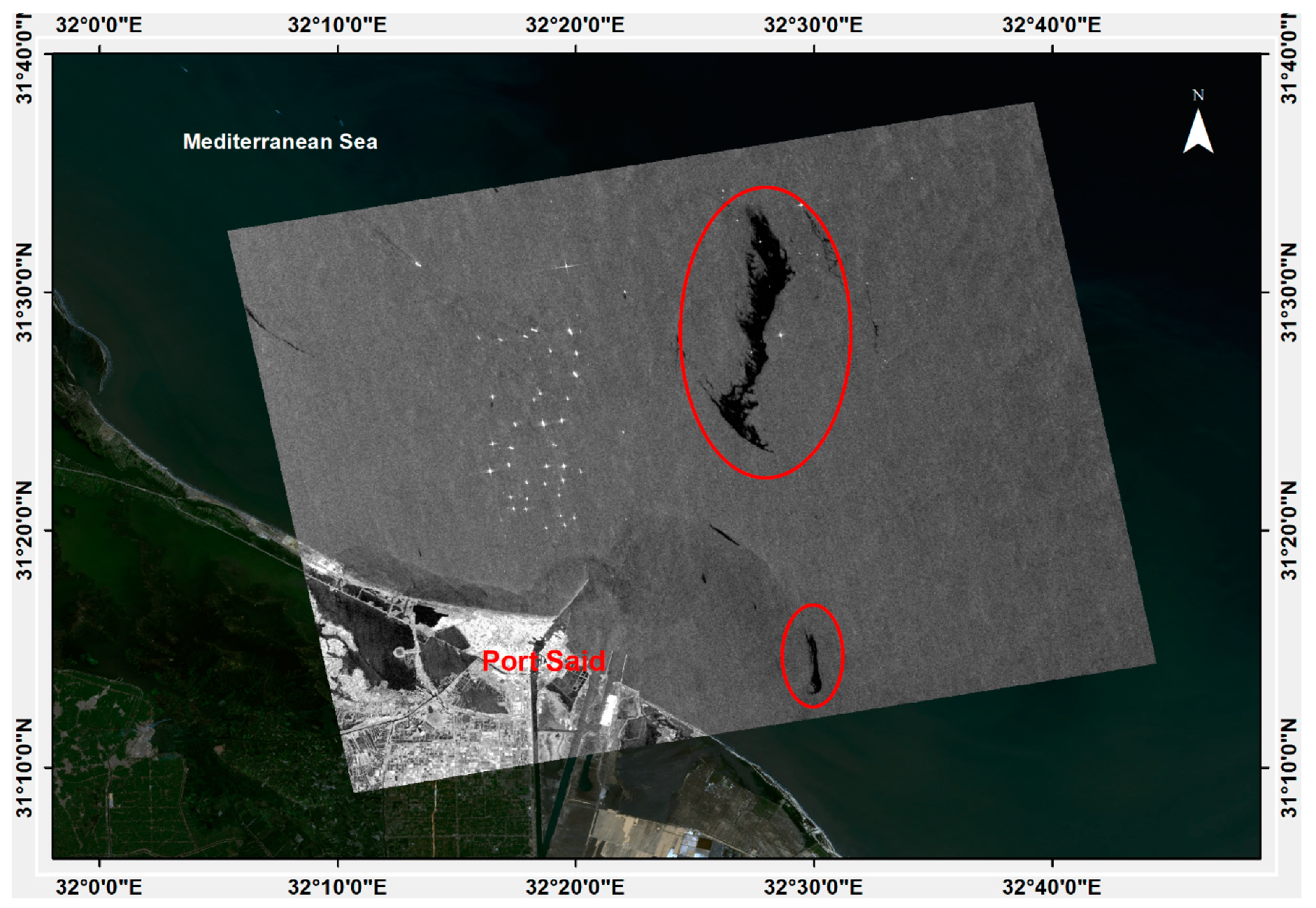
4. Results
5. Validation
6. Discussion
7. Conclusions
Author Contributions
Funding
Acknowledgments
Conflicts of Interest
References
- Brekke, C.; Solberg, A.H.S. Oil spill detection by satellite remote sensing. Remote Sens. Environ. 2005, 95, 1–13. [Google Scholar] [CrossRef]
- Singha, S.; Bellerby, T.J.; Trieschmann, O. Detection and classification of oil spill and look-alike spots from SAR imagery using an artificial neural network. In Proceedings of the 2012 IEEE International Geoscience and Remote Sensing Symposium, Munich, Germany, 22–27 July 2012; pp. 5630–5633. [Google Scholar]
- Fingas, M.F.; Charles, J. The Basics of Oil Spill Cleanup; Lewis Publishers: Boca Raton, FL, USA, 2001; ISBN 9781566705370; 9781420032598. [Google Scholar]
- Franceschetti, G.A.; Riccio, I.D.; Ruello, G.; Siviero, R. SAR raw signal simulation of oil slicks in ocean environments. IEEE Trans. Geosci. Remote Sens. 2002, 40, 1935–1949. [Google Scholar] [CrossRef]
- Alpers, W.; Holt, B.; Zeng, K. Oil spill detection by imaging radars: Challenges and pitfalls. In Proceedings of the 2017 IEEE International Geoscience and Remote Sensing Symposium, Fort Worth, TX, USA, 23–28 July 2017; pp. 1522–1525. [Google Scholar] [CrossRef]
- Fotias, V. Oil spills detection and identification with Synthetic Aperture Radar (SAR), GEO univerity. 2018. Available online: https://www.geo.university/pages/oil-spills-detection-and-identification-with-synthetic-aperture-radar-sar (accessed on 21 October 2019).
- Arslan, N. Assessment of oil spills using Sentinel 1 C-band SAR and Landsat 8 multispectral sensors. Environ. Monit. Assess. 2018, 190, 637. [Google Scholar] [CrossRef] [PubMed]
- Ferraro, G.; Trieschmann, O.; Perkovic, M.; Tarchi, D. Confidence levels in the detection of oil spills from satellite imagery: From research to the operational use. In Proceedings of SAR Image Analysis, Modeling, and Techniques XII; Modeling, and Techniques XII, SPIE Remote Sensing: Edinburgh, UK, 2012; Volume 8536, p. 85360G. [Google Scholar]
- Data Application of the Month: Oil Spill Mapping|UN-SPIDER Knowledge Portal. Available online: http://www.un-spider.org/links-and-resources/data-sources/daotm-oil-spill (accessed on 24 October 2019).
- Liu, Y.A.; MacFadyen, Z.G.J.; Weisberg, R.H. Monitoring and Modeling the Deepwater Horizon Oil Spill: A Record-Breaking Enterprise; AGU/Geophysical Monograph Series; the American Geophysical Union: Washington, DC, USA, 2011; pp. 195–271. [Google Scholar]
- El-Magd, I.A.; El Kafrawy, S.; Farag, I. Detecting oil spill contamination using airborne hyperspectral data in the River Nile, Egypt. Open J. Mar. Sci. 2014, 4, 140. [Google Scholar] [CrossRef] [Green Version]
- Kotova, L.; Espedal, H. Oil spill detection using spaceborne SAR—A brief review. In Proceedings of the 27th International Symposium on Remote Sensing Environmental, Tromso, Norway, 8–12 June 1998; pp. 791–794. [Google Scholar]
- Patin, S.A. Environmental Impact of the Offshore Oil and Gas Industry; JSTOR Ecomonitor Pub.: New York, NY, USA, 1999; Volume 1. [Google Scholar]
- How We Determine Oil Spill Volume—SkyTruth. Available online: https://skytruth.org/oil-spill-reports/oil-spill-reporting-resources/how-we-determine-oil-spill-volume/ (accessed on 21 October 2019).
- Zaki, M.S.; Ata, N.; Abdelzaher, M.F.; Hammam, A.M.M. Effects of environmental oil spills on commercial fish and shellfish in Suez Canal and Suez Gulf regions. Life Sci. J. 2014, 11, 269–274. [Google Scholar]
- Nasr, A.H.; Ahmed, M.H. Detecting oil spills in the offshore Nile delta coast using image processing of ERS SAR data. Environ. Aff. 2000, 23, 5. [Google Scholar]
- Alves, T.M.; Kokinou, E.; Zodiatis, G.; Radhakrishnan, H.; Panagiotakis, C.; Lardner, R. Multidisciplinary oil spill modeling to protect coastal communities and the environment of the Eastern Mediterranean Sea. Sci. Rep. 2016, 6, 36882. [Google Scholar] [CrossRef] [PubMed]
- Shaltout, M.; Tonbol, K. Modeling of wave propagation off Damietta-Port Said Coast, Egypt. J. Arab Inst. Navig. 2011, 27, 56–67. [Google Scholar]
- Fletcher, M.E. The Suez Canal and World Shipping, 1869–1914. J. Econ. Hist. 1958, 18, 556–573. [Google Scholar] [CrossRef]
- EO Browser|Sentinel Hub. Available online: https://www.sentinel-hub.com/explore/eobrowser (accessed on 21 October 2019).
- Richards, J. A Remote Sensing with Imaging Radar; Springer: Berlin, Germany, 2009; ISBN 9783642020193. [Google Scholar]
- Misra, A.; Balaji, R. Simple Approaches to Oil Spill Detection Using Sentinel Application Platform (SNAP)-Ocean Application Tools and Texture Analysis: A Comparative Study. J. Indian Soc. Remote Sens. 2017, 45, 1065–1075. [Google Scholar] [CrossRef]
- Lee, J.-S. Speckle analysis and smoothing of synthetic aperture radar images. Comput. Graph. Image Process. 1981, 17, 24–32. [Google Scholar] [CrossRef]
- Earth Observation ServicesCleanSeaNet service-EMSA-European Maritime Safety Agency. Available online: http://www.emsa.europa.eu/csn-menu.html (accessed on 14 October 2019).
- Solberg, A.H.S.; Volden, E. Incorporation of prior knowledge in automatic classification of oil spills in ERS SAR images. In Proceedings of the IGARSS’97. 1997 IEEE International Geoscience and Remote Sensing Symposium Proceedings. Remote Sensing—A Scientific Vision for Sustainable Development, Singapore, 3–8 August 1997; Volume 1, pp. 157–159. [Google Scholar]
- Iran Says Oil Tanker Hit by Two Missiles off SAUDI Arabia Coast|Financial Times. Available online: https://www.ft.com/content/2ae8d55a-ebef-11e9-a240-3b065ef5fc55 (accessed on 24 October 2019).
- Mehanna, S.F.; Haggag, H.M. Port said fisheries: Current status, assessment and management. In Proceedings of the 3rd Global Fisheries and Aquaculture Research Conference, Foreign Agricultural Relations (FAR), Cairo, Egypt, 29 November–1 December 2010. [Google Scholar]


| Item | Specs |
|---|---|
| Satellite (sensor) | Sentinel-1A, 1B |
| Band | C |
| Polarization | VV |
| Wavelength | 5.5 cm |
| Acquisition Mode | Interferometric Wide Swath (IW) |
| Product Type | Ground Range Detected (GRD |
| Resolution(m) | 5 × 20 |
| Swath Width (km) | 250 |
| Incidence Angle (°) | 29.1–46 |
| Repeat Frequency | 2–6 days |
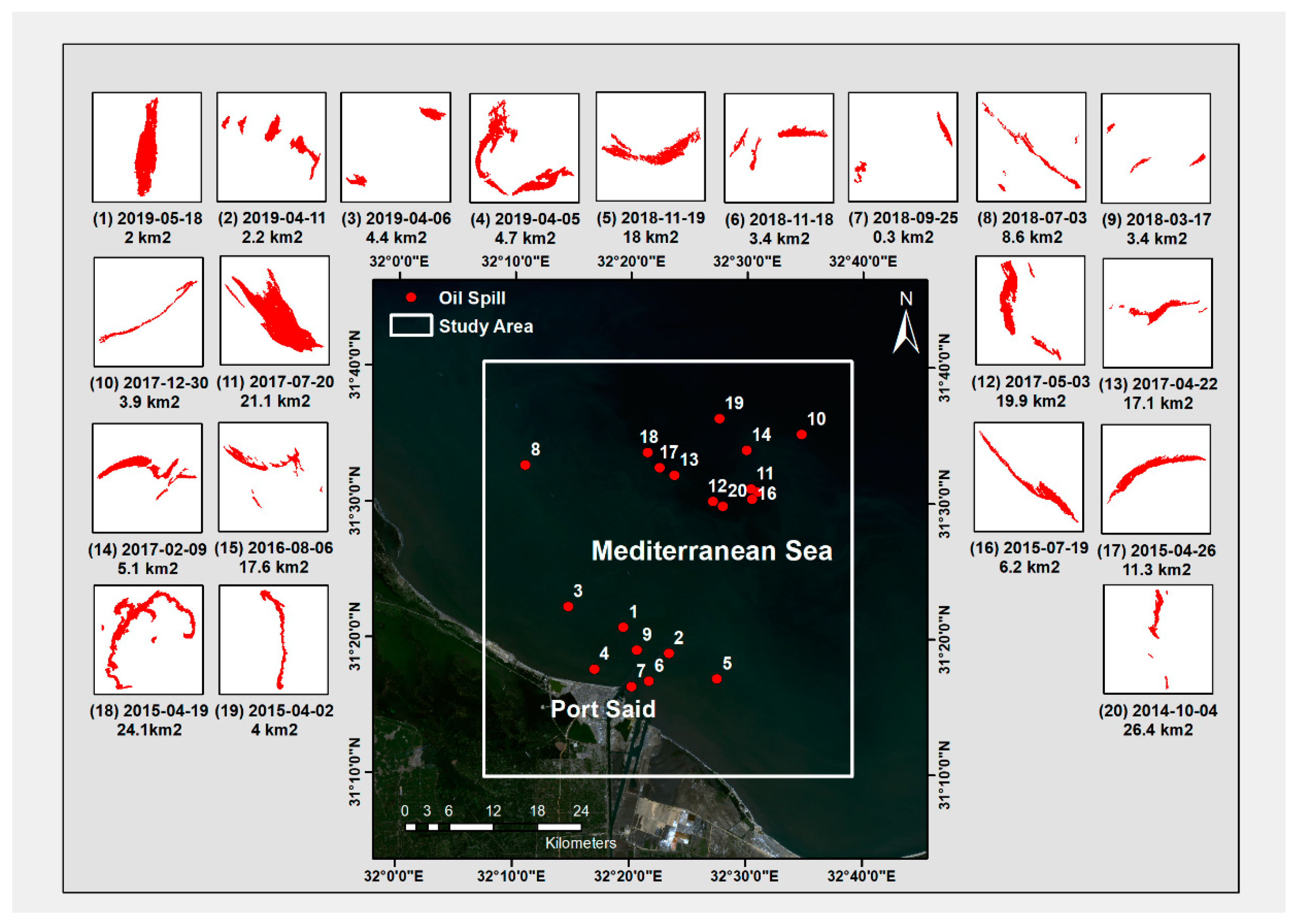
| ID on Map | Date | Longitude | Latitude | Area (km2) | Estimated Volume (m3) Based on 1 µm Thickness |
|---|---|---|---|---|---|
| 1 | 2019-05-18 | 32°19′30″E | 31°20′49″N | 2 | 2 |
| 2 | 2019-04-11 | 32°23′24″E | 31°18′55″N | 2.2 | 2.2 |
| 3 | 2019-04-06 | 32°14′43″E | 31°22′18″N | 4.4 | 4.4 |
| 4 | 2019-04-05 | 32°17′0″E | 31°17′42″N | 4.7 | 4.7 |
| 5 | 2018-11-19 | 32°27′33″E | 31°17′2″N | 18 | 18 |
| 6 | 2018-11-18 | 32°21′43″E | 31°16′51″N | 3.4 | 3.4 |
| 7 | 2018-09-25 | 32°20′12″E | 31°16′26″N | 0.3 | 0.3 |
| 8 | 2018-07-03 | 32°10′58″E | 31°32′44″N | 8.6 | 8.6 |
| 9 | 2018-03-17 | 32°20′39″E | 31°19′8″N | 3.4 | 3.4 |
| 10 | 2017-12-30 | 32°34′44″E | 31°35′5″N | 3.9 | 3.9 |
| 11 | 2017-07-20 | 32°30′24″E | 31°31′4″N | 21.1 | 21.1 |
| 12 | 2017-05-03 | 32°27′10″E | 31°30′9″N | 19.9 | 19.9 |
| 13 | 2017-04-22 | 32°23′49″E | 31°32′2″N | 17.1 | 17.1 |
| 14 | 2017-02-09 | 32°29′60″E | 31°33′54″N | 5.1 | 5.1 |
| 15 | 2016-08-06 | 32°30′60″E | 31°30′50″N | 17.6 | 17.6 |
| 16 | 2015-07-19 | 32°30′31″E | 31°30′17″N | 6.2 | 6.2 |
| 17 | 2015-04-26 | 32°22′31″E | 31°32′36″N | 11.3 | 11.3 |
| 18 | 2015-04-19 | 32°21′28″E | 31°33′42″N | 24.1 | 24.1 |
| 19 | 2015-04-02 | 32°27′40″E | 31°36′14″N | 4 | 4 |
| 20 | 2014-10-04 | 32°28′0″E | 31°29′46″N | 26.4 | 26.4 |
© 2020 by the authors. Licensee MDPI, Basel, Switzerland. This article is an open access article distributed under the terms and conditions of the Creative Commons Attribution (CC BY) license (http://creativecommons.org/licenses/by/4.0/).
Share and Cite
Abou El-Magd, I.; Zakzouk, M.; Abdulaziz, A.M.; Ali, E.M. The Potentiality of Operational Mapping of Oil Pollution in the Mediterranean Sea near the Entrance of the Suez Canal Using Sentinel-1 SAR Data. Remote Sens. 2020, 12, 1352. https://doi.org/10.3390/rs12081352
Abou El-Magd I, Zakzouk M, Abdulaziz AM, Ali EM. The Potentiality of Operational Mapping of Oil Pollution in the Mediterranean Sea near the Entrance of the Suez Canal Using Sentinel-1 SAR Data. Remote Sensing. 2020; 12(8):1352. https://doi.org/10.3390/rs12081352
Chicago/Turabian StyleAbou El-Magd, Islam, Mohamed Zakzouk, Abdulaziz M. Abdulaziz, and Elham M. Ali. 2020. "The Potentiality of Operational Mapping of Oil Pollution in the Mediterranean Sea near the Entrance of the Suez Canal Using Sentinel-1 SAR Data" Remote Sensing 12, no. 8: 1352. https://doi.org/10.3390/rs12081352