Development of a Seamless Forecast for Solar Radiation Using ANAKLIM++


Abstract
:
1. Introduction
2. Data
2.1. Numerical Weather Prediction
2.2. Nowcasting
2.3. Reference Data
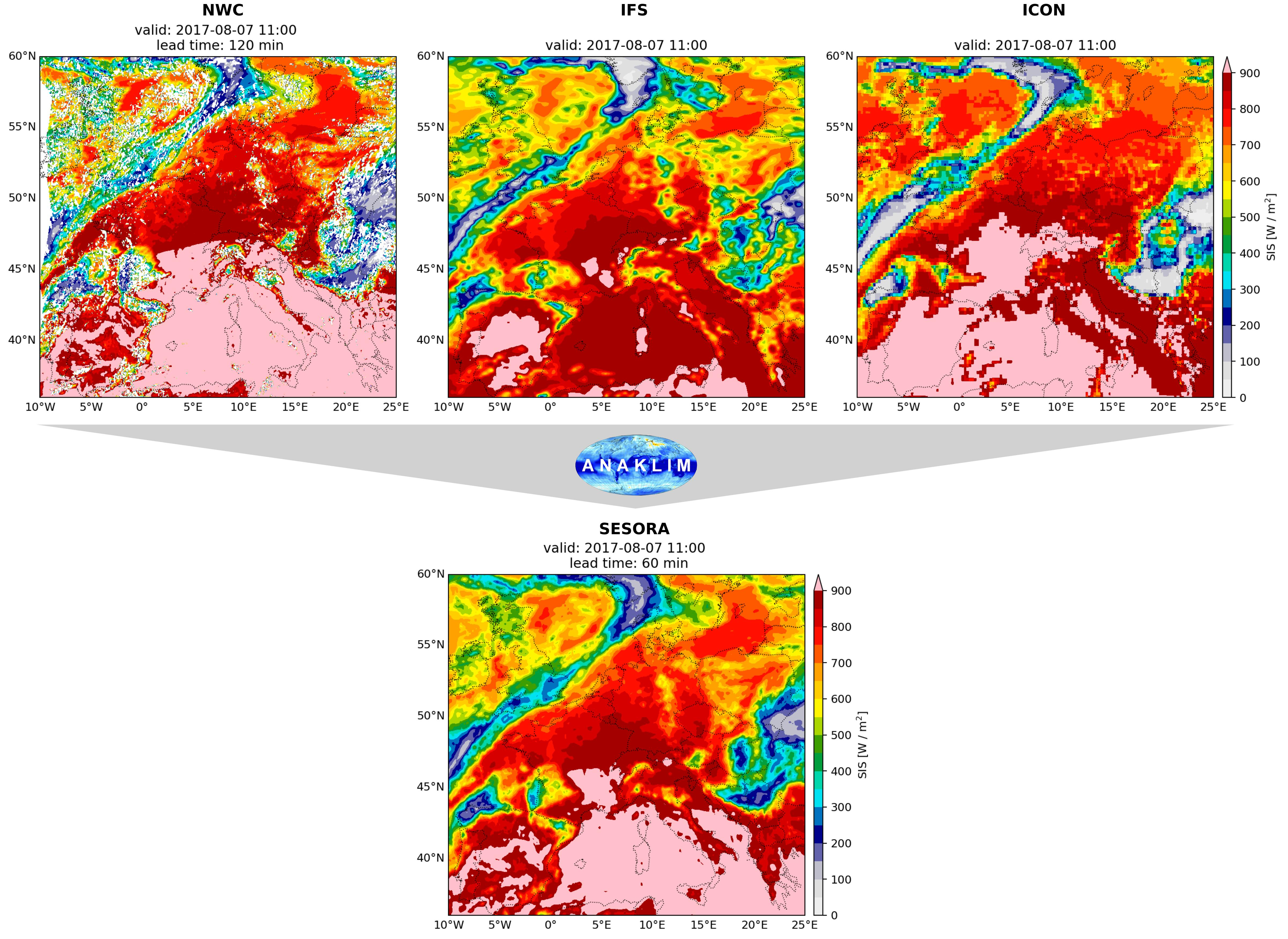
3. Method
3.1. ANAKLIM++
3.2. Simple Blending
3.3. Error Measures
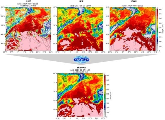
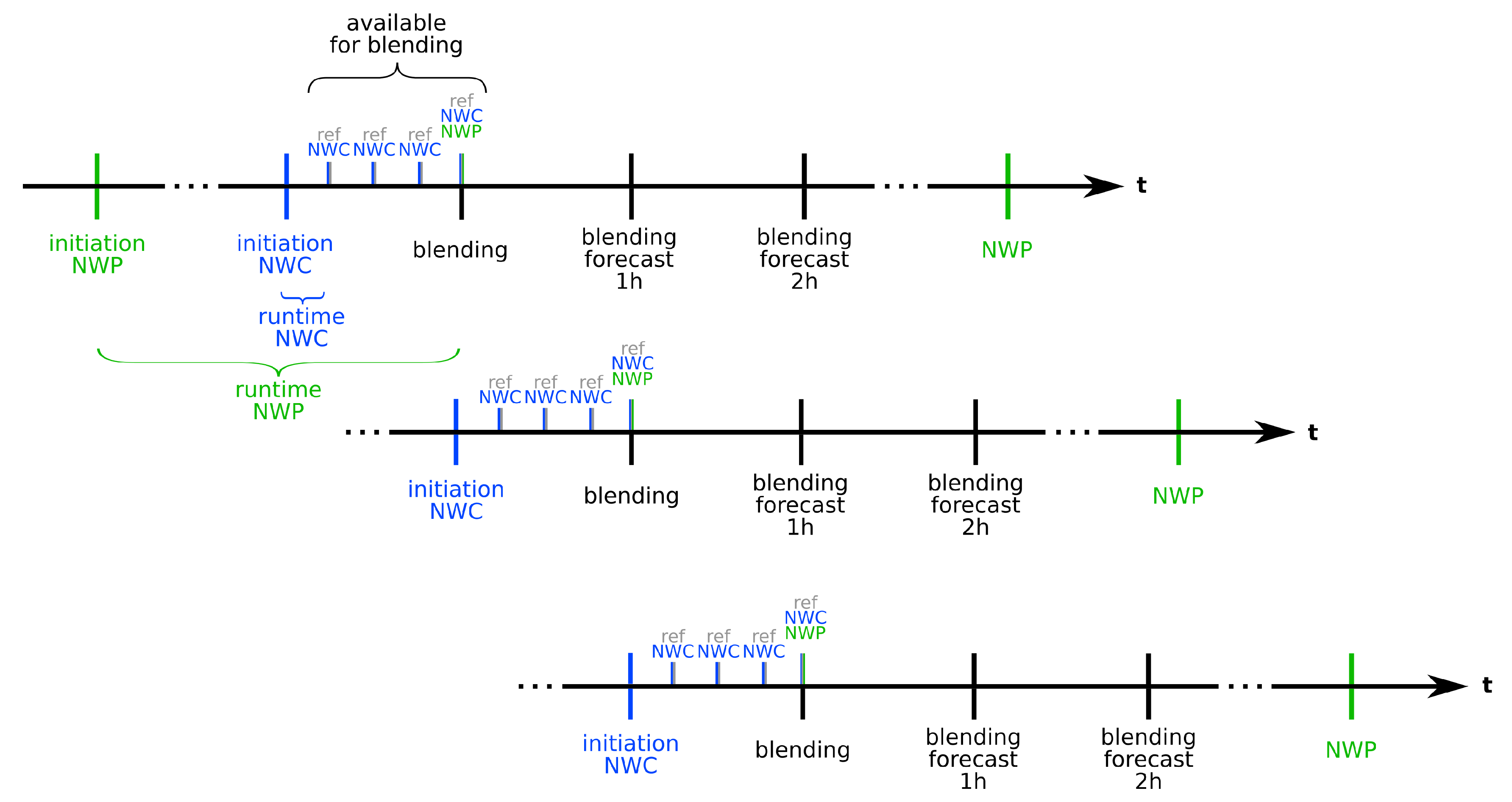
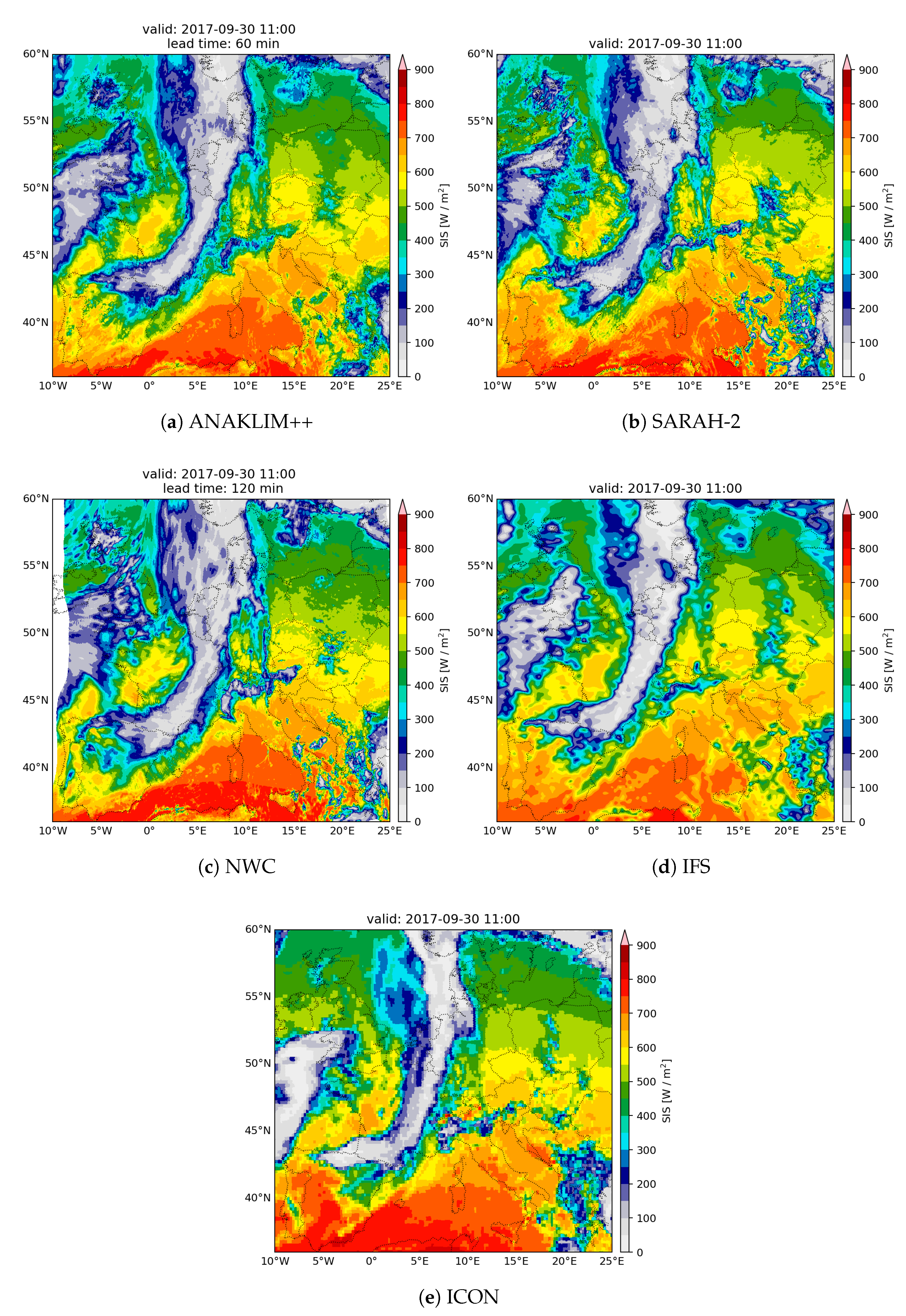
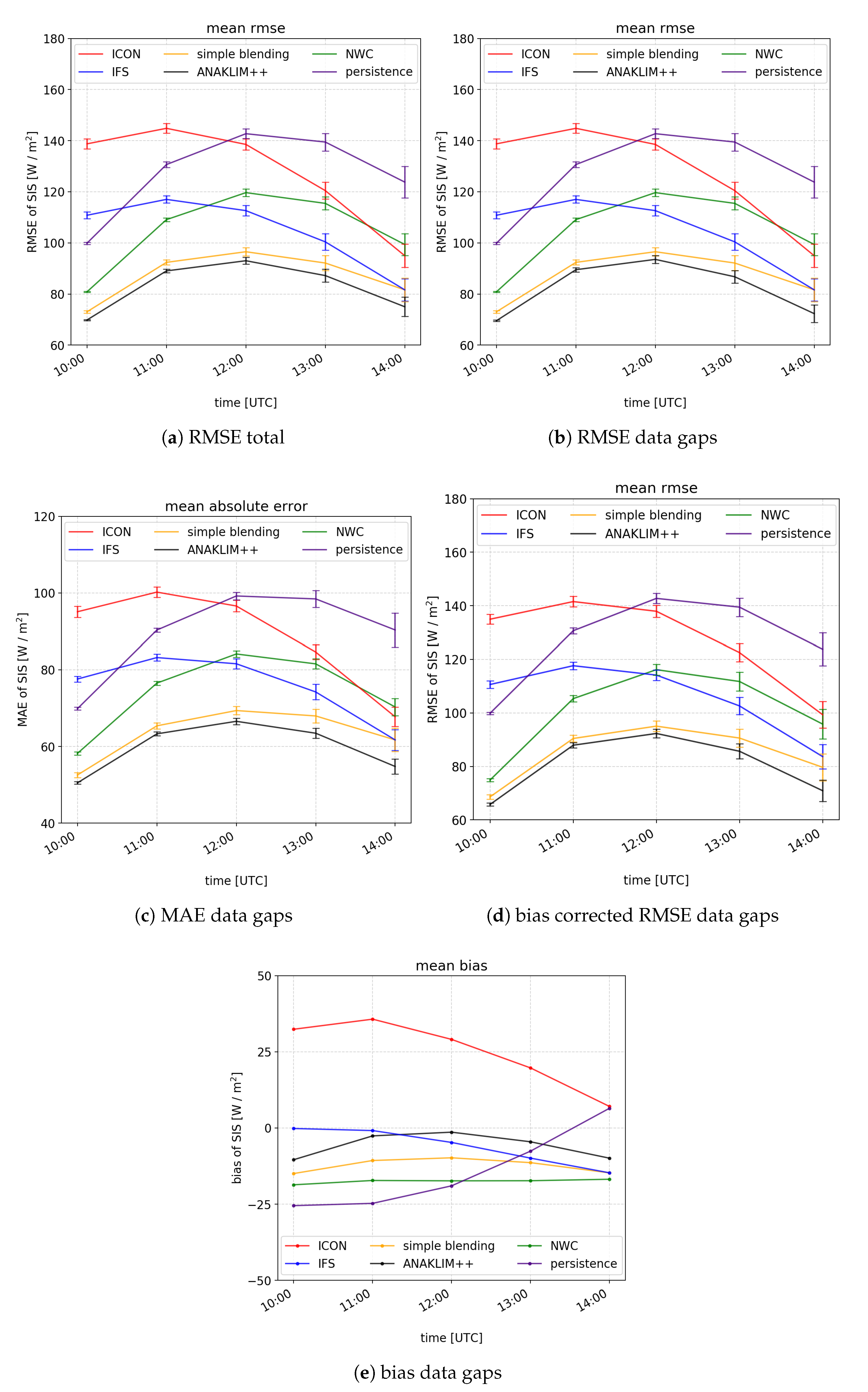
4. Results
5. Discussion
6. Conclusions
Author Contributions
Funding
Acknowledgments
Conflicts of Interest
Abbreviations
| ANAKLIM++ | Adjustment of assimilation software for the reanalysis of climate data |
| BMWi | Bundesministerium für Wirtschaft und Energie (Federal Ministry for Economic Affairs |
| and Energy) | |
| CM SAF | Climate Monitoring Satellite Application Facility |
| COSMO | Consortium for Small Scale Modeling |
| DNI | Direct Normal Irradiance |
| DWD | Deutscher Wetterdienst (German Weather Service) |
| ECMWF | European Centre for Medium-Range Weather Forecasts |
| EU | Europe |
| GHI | Global Horizontal Irradiance |
| ICON | Icosahedral Non-Hydrostatic Model |
| IFS | Integrated Forecasting System |
| MAE | Mean Absolute Error |
| MSG | Meteosat Second Generation |
| NDFD | National Digital Forecast Database |
| NN | Neural Networks |
| NWC | Nowcasting |
| NWP | Numerical Weather Prediction |
| OpenCV | Open Source Computer Vision |
| RMSE | Root Mean Square Error |
| PV | Photovoltaic |
| SARAH-2 | Surface Radiation Data Set–Heliosat |
| SESORA | Seamless Solar Radiation |
| SIS | Surface Incoming Shortwave Radiation |
| SPECMAGIC NOW | Spectrally Resolved Mesoscale Atmospheric Global Irradiance Code for Nowcasting |
| TSO | Transmission System Operator |
| WRF | Weather Research and Forecasting |
Appendix A. Investigated Cases

| Date | Weather Situation/ | Day Time (UTC) | ||||
|---|---|---|---|---|---|---|
| Cloud Type | 10 | 11 | 12 | 13 | 14 | |
| 7 August 2017 | high pressure | 48.30 | 61.64 | 67.92 | 70.94 | 67.22 |
| cirrus | 68.14 | 91.35 | 101.81 | 101.65 | 91.38 | |
| 11 August 2017 | stratiform precipitation | 49.12 | 60.80 | 63.21 | 62.88 | 59.19 |
| stratus | 72.66 | 91.68 | 94.60 | 90.85 | 81.76 | |
| 15 August 2017 | convection | 47.19 | 61.08 | 68.48 | 73.96 | 69.32 |
| cumulus nimbus | 70.99 | 94.97 | 104.18 | 107.58 | 96.68 | |
| 28 August 2017 | high pressure | 51.01 | 67.50 | 73.41 | 71.34 | 65.25 |
| cirrus | 70.78 | 96.63 | 106.4 | 101.67 | 89.50 | |
| 29 August 2017 | high pressure | 48.05 | 61.97 | 66.57 | 67.04 | 61.18 |
| cirrus | 70.22 | 92.45 | 99.91 | 98.03 | 86.24 | |
| 1 September 2017 | stratiform precipitation | 50.61 | 67.90 | 73.91 | 73.13 | 64.57 |
| stratus | 73.75 | 100.72 | 106.94 | 102.02 | 86.28 | |
| 7 September 2017 | broken clouds | 52.58 | 70.20 | 75.34 | 70.30 | 59.89 |
| cumulus | 72.75 | 95.96 | 100.94 | 92.28 | 75.54 | |
| 17 September 2017 | broken clouds | 48.19 | 67.19 | 72.16 | 66.35 | 53.82 |
| cumulus | 71.23 | 99.70 | 104.32 | 91.82 | 70.97 | |
| 26 September 2017 | convection | 51.18 | 66.56 | 71.07 | 65.65 | 52.12 |
| cumulus nimbus | 68.50 | 90.47 | 95.84 | 86.40 | 66.54 | |
| 30 September 2017 | front & convection | 41.83 | 54.12 | 56.35 | 51.44 | 41.38 |
| stratus & cumulus | 59.28 | 77.83 | 79.33 | 69.97 | 54.94 | |
| 1 October 2017 | front & convection | 56.31 | 66.78 | 67.82 | 62.36 | 53.00 |
| stratus & cumulus | 70.67 | 85.74 | 86.00 | 76.57 | 62.67 | |
| 2 October 2017 | stratiform precipitation | 60.52 | 73.19 | 74.20 | 67.50 | 54.72 |
| stratus | 76.69 | 95.71 | 97.24 | 87.35 | 69.68 | |
| 3 October 2017 | broken clouds | 53.53 | 60.70 | 60.93 | 55.04 | 45.34 |
| cumulus | 68.14 | 79.91 | 79.89 | 69.93 | 55.97 | |
| 4 October 2017 | stratiform precipitation | 51.49 | 58.76 | 58.12 | 52.19 | 41.70 |
| stratus | 65.95 | 77.37 | 76.85 | 68.89 | 55.14 | |
| 7 October 2017 | stratiform precipitation | 47.81 | 51.14 | 49.07 | 41.82 | 33.14 |
| stratus | 63.50 | 72.03 | 68.84 | 56.10 | 41.51 | |
References
- Lorenz, E.; Kühnert, J.; Heinemann, D. Short term forecasting of solar irradiance by combining satellite data and numerical weather predictions. In Proceedings of the 27th European PV Solar Energy Conference (EU PVSEC), Frankfurt, Germany, 24–28 September 2012; Volume 2428, p. 44014405. [Google Scholar]
- Fraunhofer ISE. Homepage of the Fraunhofer Institute for Solar Energy Systems. 2020. Available online: https://www.ise.fraunhofer.de/ (accessed on 24 August 2020).
- Huang, J.; Rikus, L.J.; Qin, Y.; Katzfey, J. Assessing model performance of daily solar irradiance forecasts over Australia. Sol. Energy 2018, 176, 615–626. [Google Scholar] [CrossRef]
- Raza, M.Q.; Nadarajah, M.; Ekanayake, C. On recent advances in PV output power forecast. Sol. Energy 2016, 136, 125–144. [Google Scholar] [CrossRef]
- Inman, R.H.; Pedro, H.T.; Coimbra, C.F. Solar forecasting methods for renewable energy integration. Prog. Energy Combust. Sci. 2013, 39, 535–576. [Google Scholar] [CrossRef]
- Vrettos, E.; Gehbauer, C. A Hybrid Approach for Short-Term PV Power Forecasting in Predictive Control Applications. In Proceedings of the 2019 IEEE Milan PowerTech, Milan, Italy, 23–27 June 2019; pp. 1–6. [Google Scholar]
- Barbieri, F.; Rajakaruna, S.; Ghosh, A. Very short-term photovoltaic power forecasting with cloud modeling: A review. Renew. Sustain. Energy Rev. 2017, 75, 242–263. [Google Scholar] [CrossRef] [Green Version]
- Lenzi, V.; Ulbig, A.; Andersson, G. Impacts of forecast accuracy on grid integration of renewable energy sources. In Proceedings of the 2013 IEEE Grenoble Conference, Grenoble, France, 16–20 June 2013; pp. 1–6. [Google Scholar]
- Pinson, P. Estimation of the Uncertainty in Wind Power Forecasting. Ph.D. Thesis, École Nationale Supérieure des Mines de Paris, Paris, France, 2006. Available online: https://pastel.archives-ouvertes.fr/pastel-00002187 (accessed on 30 August 2020).
- Wolff, B.; Kühnert, J.; Lorenz, E.; Kramer, O.; Heinemann, D. Comparing support vector regression for PV power forecasting to a physical modeling approach using measurement, numerical weather prediction, and cloud motion data. Sol. Energy 2016, 135, 197–208. [Google Scholar] [CrossRef]
- Kurz, C. From Nowcasting to Day Ahead Forecasting: Application of Combinational PV Power Forecasts. ICEM. 2018. Available online: http://www.wemcouncil.org/wp/wp-content/uploads/2016/12/icem_20180524_room1_0950_kurz.pdf (accessed on 29 May 2020).
- Arndt, E. Vergleich von Kurzfrist-Strahlungsvorhersagen (Nowcasting) mit Vorhersagen aus Numerischen Wettermodellen im Kontext der Nahtlosen Strahlungsvorhersage. Master’s Thesis, Johann Wolfgang Goethe-University Frankfurt am Main, Frankfurt, Germany, 2019. [Google Scholar]
- Kilambi, A.; Zawadzki, I. An evaluation of ensembles based upon MAPLE precipitation nowcasts and NWP precipitation forecasts. In Proceedings of the 32nd Conf. on Radar Meteorology, Amer. Meteor. Soc., Albuquerque, NM, USA, 24–29 October 2005; Volume 4. [Google Scholar]
- Yang, D.; Wu, E.; Kleissl, J. Operational solar forecasting for the real-time market. Int. J. Forecast. 2019, 35, 1499–1519. [Google Scholar] [CrossRef]
- Perez, R.; Kivalov, S.; Schlemmer, J.; Hemker, K., Jr.; Renné, D.; Hoff, T.E. Validation of short and medium term operational solar radiation forecasts in the US. Sol. Energy 2010, 84, 2161–2172. [Google Scholar] [CrossRef]
- Aguiar, L.M.; Pereira, B.; Lauret, P.; Díaz, F.; David, M. Combining solar irradiance measurements, satellite-derived data and a numerical weather prediction model to improve intra-day solar forecasting. Renew. Energy 2016, 97, 599–610. [Google Scholar] [CrossRef] [Green Version]
- Nonnenmacher, L.; Coimbra, C.F. Streamline-based method for intra-day solar forecasting through remote sensing. Sol. Energy 2014, 108, 447–459. [Google Scholar] [CrossRef]
- Gentile, S.; Di Paola, F.; Cimini, D.; Gallucci, D.; Geraldi, E.; Larosa, S.; Nilo, S.T.; Ricciardelli, E.; Ripepi, E.; Viggiano, M.; et al. 3D-VAR Data Assimilation of SEVIRI Radiances for the Prediction of Solar Irradiance in Italy Using WRF Solar Mesoscale Model—Preliminary Results. Remote Sens. 2020, 12, 920. [Google Scholar] [CrossRef] [Green Version]
- Bauer, P.; Ohring, G.; Kummerow, C.; Auligne, T. Assimilating Satellite Observations of Clouds and Precipitation into NWP Models. Bull. Am. Meteorol. Soc. 2011, 92, ES25–ES28. [Google Scholar] [CrossRef] [Green Version]
- Huertas-Tato, J.; Aler, R.; Galván, I.M.; Rodríguez-Benítez, F.J.; Arbizu-Barrena, C.; Pozo-Vázquez, D. A short-term solar radiation forecasting system for the Iberian Peninsula. Part 2: Model blending approaches based on machine learning. Sol. Energy 2020, 195, 685–696. [Google Scholar] [CrossRef]
- Tascikaraoglu, A.; Uzunoglu, M. A review of combined approaches for prediction of short-term wind speed and power. Renew. Sustain. Energy Rev. 2014, 34, 243–254. [Google Scholar] [CrossRef]
- Tuohy, A.; Zack, J.; Haupt, S.E.; Sharp, J.; Ahlstrom, M.; Dise, S.; Grimit, E.; Mohrlen, C.; Lange, M.; Casado, M.G.; et al. Solar forecasting: Methods, challenges, and performance. IEEE Power Energy Mag. 2015, 13, 50–59. [Google Scholar] [CrossRef]
- Bowler, N.E.; Pierce, C.E.; Seed, A.W. STEPS: A probabilistic precipitation forecasting scheme which merges an extrapolation nowcast with downscaled NWP. Q. J. R. Meteorol. Soc. 2006, 132, 2127–2155. [Google Scholar] [CrossRef]
- Mellit, A.; Pavan, A.M. A 24-h forecast of solar irradiance using artificial neural network: Application for performance prediction of a grid-connected PV plant at Trieste, Italy. Sol. Energy 2010, 84, 807–821. [Google Scholar] [CrossRef]
- Rehman, S.; Mohandes, M. Artificial neural network estimation of global solar radiation using air temperature and relative humidity. Energy Policy 2008, 36, 571–576. [Google Scholar] [CrossRef] [Green Version]
- Bosch, J.; Lopez, G.; Batlles, F. Daily solar irradiation estimation over a mountainous area using artificial neural networks. Renew. Energy 2008, 33, 1622–1628. [Google Scholar] [CrossRef]
- Sfetsos, A.; Coonick, A. Univariate and multivariate forecasting of hourly solar radiation with artificial intelligence techniques. Sol. Energy 2000, 68, 169–178. [Google Scholar] [CrossRef]
- Ghanbarzadeh, A.; Noghrehabadi, A.; Assareh, E.; Behrang, M. Solar radiation forecasting based on meteorological data using artificial neural networks. In Proceedings of the 2009 7th IEEE International Conference on Industrial Informatics, Wales, UK, 23–26 June 2009; pp. 227–231. [Google Scholar]
- Mohandes, M.; Rehman, S.; Halawani, T. Estimation of global solar radiation using artificial neural networks. Renew. Energy 1998, 14, 179–184. [Google Scholar] [CrossRef]
- Marquez, R.; Pedro, H.T.; Coimbra, C.F. Hybrid solar forecasting method uses satellite imaging and ground telemetry as inputs to ANNs. Sol. Energy 2013, 92, 176–188. [Google Scholar] [CrossRef]
- Marquez, R.; Coimbra, C.F. Forecasting of global and direct solar irradiance using stochastic learning methods, ground experiments and the NWS database. Sol. Energy 2011, 85, 746–756. [Google Scholar] [CrossRef]
- Boata, R.S.; Gravila, P. Functional fuzzy approach for forecasting daily global solar irradiation. Atmos. Res. 2012, 112, 79–88. [Google Scholar] [CrossRef]
- Moghaddamnia, A.; Remesan, R.; Kashani, M.H.; Mohammadi, M.; Han, D.; Piri, J. Comparison of LLR, MLP, Elman, NNARX and ANFIS Models—With a case study in solar radiation estimation. J. Atmos. Sol. Terr. Phys. 2009, 71, 975–982. [Google Scholar] [CrossRef]
- Bacher, P.; Madsen, H.; Nielsen, H.A. Online short-term solar power forecasting. Sol. Energy 2009, 83, 1772–1783. [Google Scholar] [CrossRef] [Green Version]
- Dambreville, R.; Blanc, P.; Chanussot, J.; Boldo, D. Very short term forecasting of the Global Horizontal Irradiance using a spatio-temporal autoregressive model. Renew. Energy 2014, 72, 291–300. [Google Scholar] [CrossRef]
- Mora-Lopez, L.; Sidrach-de Cardona, M. Multiplicative ARMA models to generate hourly series of global irradiation. Sol. Energy 1998, 63, 283–291. [Google Scholar] [CrossRef]
- Hocaoğlu, F.O. Stochastic approach for daily solar radiation modeling. Sol. Energy 2011, 85, 278–287. [Google Scholar] [CrossRef]
- Akarslan, E.; Hocaoğlu, F.O.; Edizkan, R. A novel MD (multi-dimensional) linear prediction filter approach for hourly solar radiation forecasting. Energy 2014, 73, 978–986. [Google Scholar] [CrossRef]
- Sanfilippo, A.; Martin-Pomares, L.; Mohandes, N.; Perez-Astudillo, D.; Bachour, D. An adaptive multi-modeling approach to solar nowcasting. Sol. Energy 2016, 125, 77–85. [Google Scholar] [CrossRef]
- Arbizu-Barrena, C.; Ruiz-Arias, J.A.; Rodríguez-Benítez, F.J.; Pozo-Vázquez, D.; Tovar-Pescador, J. Short-term solar radiation forecasting by advecting and diffusing MSG cloud index. Sol. Energy 2017, 155, 1092–1103. [Google Scholar] [CrossRef]
- Kühnert, J. Development of a Photovoltaic Power Prediction System for Forecast Horizons of Several Hours. Ph.D. Thesis, Universität Oldenburg, Oldenburg, Germany, 2016. [Google Scholar]
- Haupt, S.E.; Kosovic, B.; Jensen, T.; Lee, J.; Jimenez, P.; Lazo, J.; Cowie, J.; McCandless, T.; Pearson, J.; Weiner, G.; et al. The SunCast solar-power forecasting system: The results of the public-private-academic partnership to advance solar power forecasting. In Research Applications Laboratory, Weather Systems and Assessment Program (US); National Center for Atmospheric Research (NCAR): Boulder, CO, USA, 2016. [Google Scholar]
- Myers, W.; Wiener, G.; Linden, S.; Haupt, S. A consensus forecasting approach for improved turbine hub height wind speed predictions. In Proceedings of the WindPower, Anaheim, CA, USA, 22–25 May 2011. [Google Scholar]
- Haupt, S.E.; Kosović, B.; Jensen, T.; Lazo, J.K.; Lee, J.A.; Jiménez, P.A.; Cowie, J.; Wiener, G.; McCandless, T.C.; Rogers, M.; et al. Building the Sun4Cast system: Improvements in solar power forecasting. Bull. Am. Meteorol. Soc. 2018, 99, 121–136. [Google Scholar] [CrossRef]
- Martínez Sánchez, M.; Callado, A. nowcRadiation seamless-nowcasting solar radiation using satellite and high resolution numerical model output. In Proceedings of the 3rd European Nowcasting Conference, Madrid, Spain, 24–26 April 2019. [Google Scholar]
- Perez, R.; Kankiewicz, A.; Schlemmer, J.; Hemker, K.; Kivalov, S. A new operational solar resource forecast model service for PV fleet simulation. In Proceedings of the 2014 IEEE 40th Photovoltaic Specialist Conference (PVSC), Denver, CO, USA, 8–13 June 2014; pp. 0069–0074. [Google Scholar]
- Reinert, D.; Prill, F.; Frank, H.; Denhard, M.; Zängl, G. Database reference manual for ICON and ICON-EPS. Version 2018, 1, 35. [Google Scholar]
- European Centre for Medium-Range Weather Forecasts. IFS Documentation Part IV: Physical Processes. In IFS Documentation CY47R1; Number 4 in IFS Documentation; ECMWF: Reading, UK, 2020. [Google Scholar]
- Groß, A.; Fränkel, S.; Seelge, M.; Schömer, E. ANAKLIM-Plus Plus Projektdokumentation; Johannes Gutenberg University: Mainz, Germany, 2014. [Google Scholar]
- Groß, A.; Müller, R.; Schömer, E.; Trentmann, J. Terrestrial cross-calibrated assimilation of various datasources. In Proceedings of the EGU General Assembly Conference Abstracts, Vienna, Austria, 27 April–2 May 2014; Volume 16. [Google Scholar]
- Urbich, I.; Bendix, J.; Müller, R. The Seamless Solar Radiation (SESORA) Forecast for Solar Surface Irradiance–Method and Validation. Remote Sens. 2019, 11, 2576. [Google Scholar] [CrossRef] [Green Version]
- Urbich, I.; Bendix, J.; Müller, R. A Novel Approach for the Short-Term Forecast of the Effective Cloud Albedo. Remote Sens. 2018, 10, 955. [Google Scholar] [CrossRef] [Green Version]
- Mathiesen, P.; Kleissl, J. Evaluation of numerical weather prediction for intra-day solar forecasting in the continental United States. Sol. Energy 2011, 85, 967–977. [Google Scholar] [CrossRef] [Green Version]
- OpenCV. Homepage of OpenCV. 2020. Available online: http://opencv.org/ (accessed on 21 April 2020).
- Müller, R.; Behrendt, T.; Hammer, A.; Kemper, A. A New Algorithm for the Satellite-Based Retrieval of Solar Surface Irradiance in Spectral Bands. Remote Sens. 2012, 4, 622–647. [Google Scholar] [CrossRef] [Green Version]
- Pfeifroth, U.; Sanchez-Lorenzo, A.; Manara, V.; Trentmann, J.; Hollmann, R. Trends and Variability of Surface Solar Radiation in Europe Based On Surface-and Satellite-Based Data Records. J. Geophys. Res. Atmos. 2018, 123, 1735–1754. [Google Scholar] [CrossRef]
- BSRN. Homepage of the Baseline Surface Radiation Network. 2020. Available online: https://bsrn.awi.de/ (accessed on 23 July 2020).
- Pfeifroth, U.; Kothe, S.; Müller, R.; Trentmann, J.; Hollmann, R.; Fuchs, P.; Werscheck, M. Surface Radiation Data Set–Heliosat (SARAH)—Edition 2, Satellite Application Facility on Climate Monitoring; EGUGA: Offenbach, Germany, 2017. [Google Scholar] [CrossRef]
- Sengupta, M.; Habte, A.; Kurtz, S.; Dobos, A.; Wilbert, S.; Lorenz, E.; Stoffel, T.; Renné, D.; Gueymard, C.A.; Myers, D.; et al. Best Practices Handbook for the Collection and Use of Solar Resource Data for Solar Energy Applications, Chapter 7: Forecasting Solar Radiation; National Renewable Energy Laboratory: Golden, CO, USA, 2015.
- Mathiesen, P.; Collier, C.; Kleissl, J. A high-resolution, cloud-assimilating numerical weather prediction model for solar irradiance forecasting. Sol. Energy 2013, 92, 47–61. [Google Scholar] [CrossRef] [Green Version]
- Perez, R.; Lorenz, E.; Pelland, S.; Beauharnois, M.; Van Knowe, G.; Hemker Jr, K.; Heinemann, D.; Remund, J.; Müller, S.C.; Traunmüller, W.; et al. Comparison of numerical weather prediction solar irradiance forecasts in the US, Canada and Europe. Sol. Energy 2013, 94, 305–326. [Google Scholar] [CrossRef]
- Remund, J.; Perez, R.; Lorenz, E. Comparison of solar radiation forecasts for the USA. In Proceedings of the 23rd European PV Conference, Valencia, Spain, 1–5 September 2008; Volume 14. [Google Scholar]


| Product | Method | Operator | Horizontal Resolution | Temporal Resolution |
|---|---|---|---|---|
| NWC | Short-term Forecast | DWD | 5 km | 15 min |
| ICON | Numerical Weather Prediction | DWD | 13 km | 1 h |
| IFS | Numerical Weather Prediction | ECMWF | 9 km | 1 h |
| SESORA | Blended Forecast | DWD | 5 km | 1 h |
| Product | Start of Blending | Runtime | Model Initialization | Time of Availability | Lead Time at Start of Blending |
|---|---|---|---|---|---|
| Nowcasting | 08 UTC | 15 min | 07 UTC | 07:15 UTC | 1 h |
| 09 UTC | 08 UTC | 08:15 UTC | 1 h | ||
| ICON | 08 UTC | 3 h | 03 UTC | 06:00 UTC | 5 h |
| 09 UTC | 06 UTC | 09:00 UTC | 3 h | ||
| IFS | 08 UTC | 6 h | 00 UTC | 06:00 UTC | 8 h |
| 09 UTC | 00 UTC | 06:00 UTC | 9 h |
| Product | Lead Time (h) | ||||
|---|---|---|---|---|---|
| 1 | 2 | 3 | 4 | 5 | |
| SIS NWC with gaps | 0.75 | 0.55 | 0.35 | 0.15 | 0 |
| SIS NWC inverse | 0.05 | 0.10 | 0.15 | 0.20 | 0.25 |
| IFS | 0.15 | 0.25 | 0.35 | 0.45 | 0.50 |
| ICON | 0.05 | 0.10 | 0.15 | 0.20 | 0.25 |
Publisher’s Note: MDPI stays neutral with regard to jurisdictional claims in published maps and institutional affiliations. |
© 2020 by the authors. Licensee MDPI, Basel, Switzerland. This article is an open access article distributed under the terms and conditions of the Creative Commons Attribution (CC BY) license (http://creativecommons.org/licenses/by/4.0/).
Share and Cite
Urbich, I.; Bendix, J.; Müller, R. Development of a Seamless Forecast for Solar Radiation Using ANAKLIM++. Remote Sens. 2020, 12, 3672. https://doi.org/10.3390/rs12213672
Urbich I, Bendix J, Müller R. Development of a Seamless Forecast for Solar Radiation Using ANAKLIM++. Remote Sensing. 2020; 12(21):3672. https://doi.org/10.3390/rs12213672
Chicago/Turabian StyleUrbich, Isabel, Jörg Bendix, and Richard Müller. 2020. "Development of a Seamless Forecast for Solar Radiation Using ANAKLIM++" Remote Sensing 12, no. 21: 3672. https://doi.org/10.3390/rs12213672