1. Introduction
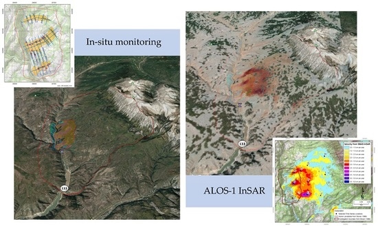
The “East Muddy Creek Landslide Complex” is located in the Muddy Creek drainage of the Gunnison River basin on the western flanks of the Ragged Mountains in Gunnison County, Colorado, USA (
Figure 1). The active and reactivating landslide complex has been investigated over decades during different periods of reactivation [
1,
2,
3,
4]. Previous studies identified the spatial extent of three slow moving landslides [
4,
5,
6,
7] that destroyed Colorado State Highway 133 from 1986 to 1987. The landslide complex is recognized by State of Colorado and federal agencies as a significant hazard, endangering both transportation routes, the nearby Paonia Reservoir, and Paonia State Park, located immediately downstream. The three active landslides form part of a larger hillslope with geomorphic features indicative of historical landslide activity. Previous geological mapping of this larger hillslope noted hummocky terrain, truncated drainage networks, and sag ponds [
2,
8,
9]. These studies did not classify temporal characteristics with regard to activity or dormancy. Such a temporal classification using field mapping is difficult, especially when deformation activity is slow and over large regions of spatial extent.
This paper presents a case study of previously unknown landslide activity within the western hillslope of the Ragged Mountains using Advanced Land Observing Satellite-1 (ALOS-1) Interferometric Synthetic Aperture Radar (InSAR) between 2007 and 2011. We describe the interpretation of newly detected very slow to extremely slow, creep style deformation with greatly expanded spatial extent observed through InSAR analysis [
10]. Using high resolution velocity mapping of the hillslope, we also describe new geomorphological features detected with the radar imagery and present the advantages and limitations of InSAR analysis in landslide recognition studies. We conclude with a discussion of the implications of this newly recognized activity to the geomorphic development of the Ragged Mountain Range in Colorado, USA.
Figure 1 also shows the three active landslides identified by previous investigations [
1,
2,
3,
4,
5,
6,
7], and the investigation area of this study. The inserted photo of the western hillslope below the Ragged Mountains has been provided by courtesy of L. Weyers.
1.1. Landslide Recognition and Radar Remote Sensing
Earth observation (EO) methods of radar interferometry, lidar remote sensing, and advanced image processing are increasingly successful in estimating ground surface deformation either occurred naturally or induced by human activities, e.g. [
11,
12,
13,
14,
15,
16,
17]. These EO methods are powerful in identifying and characterizing active slope deformations both in spatial scale and magnitude of displacement [
18,
19,
20,
21,
22,
23]. Radar interferometric measurements provide landslide researchers with a precision that is complementary to in-situ geotechnical instrumentation; additionally, the EO methods provide continuous spatial coverage of the measurements [
24]. A successful in-situ instrumentation campaigns requires initial recognition of landslide activity to design a plan to monitor critical zones, and can be limited by not siting instrumentation correctly, or the damage of the instrumentation due to the mass movement of the slope [
25,
26]. InSAR imagery can play a vital role in assisting this initial detection of spatial extents through the creation of continuous field of measurements, and in identifying active and inactive zones for better instrumentation installation. The tasks of landslide “recognition” comprises of three main categories [
20]: (1) reconnaissance, recognition, and classification; (2) monitoring and characterization; and (3) hazard and risk assessment.
The framework by Scaoini et al. [
20] emphasizes the need for feature detection in spatial extents, displacement magnitude, movement seasonality. Using InSAR methods to detect slow landslide movement on the Ragged Mountains hillslope presents a unique opportunity to examine a case of EO based landslide recognition. We contrast this approach with previous investigations and other methods to monitor the ground displacement on the hillslope. This study area was selected based on InSAR analysis of an area of previously known landslide activity in the East Muddy Creek Landslide Complex.
1.2. Geological Setting of the Study Area
The southwestern flanks of the Ragged Mountains in Gunnison County, Colorado consist of a number of active and historical slope disturbances that have been investigated with a range of studies [
4,
5,
8]. These slopes are mapped as “inactive” landslide deposits of reworked glacial till [
8,
9] or simply labeled “ancient” landslide deposits [
9]. Natural hazard and transportation risk studies were completed on three spatially distinct active landslides: “North”, “Central”, and “South” after reactivations events in 1986 and 1987 [
26]. The landslide materials rest upon the surficial Wasatch Formation (Tw) that overlies the Ohio Creek Sandstone (Koc). The sedimentary rocks in the area of the landslide complex are gently folded into a N-S trending syncline. The contact between the Tw and the Koc is unconformable and has been recognized as a likely mechanism for “dip slip” landslide slip planes [
2,
5,
9]. The Ragged Mountain Lacolith (Tqmp) that abuts the hillslope of the complex is interpreted as Eocene age possibly coeval with the Wasatch formation.
The Muddy Creek landslides caused significant damage to Colorado State Highway 133 from 1986 to 1987 [
7]. The landslide complex is recognized by state and federal agencies as a significant hazard, endangering both transportation routes as well as the nearby Paonia Reservoir, located immediately downstream of the East Muddy Creek. The reservoir is vulnerable to impacts from sedimentation, landslide damming, back flooding and overtopping seiches [
6].
Particular concerns from increased reactivation are damage to the highway, the formation of landslide dams, and channel sedimentation [
1,
3,
7]. Three dimensional subsurface modeling and geological investigation of the three reactivations were conducted to create a framework for further study. Modeling efforts included determining the relative thicknesses of the landslide masses [
2]. The landslides have been periodically monitored by the US Bureau of Reclamation (USBR) using a prism-based survey measurement through 2007. Previous studies all note the high likelihood of uncharacterized zones of landslide activity within the “Apron” of landslide deposits covering the hillslope below the Ragged Mountains (
Figure 2).
Residences and occupied structures exist on the slope above the known active landslides. Energy infrastructures have been established in the area as recently as 2011 [
27] including natural gas wells, pipeline infrastructure, and liquefied natural gas gathering stations [
28]. Even “extremely slow” displacement velocities are hazardous to linear structures that penetrate slip planes in the subsurface or shear zones on surficial installations.
1.3. Previous Evaluation of Landslide Movement
Among all the previous studies, the investigation by Stover and Cannon [
1] is one of the most thorough studies, which concluded that the landslides have reached an “equilibrium state”. This description was used broadly to describe the much lower rate of movement observed in the years after major movements in 1986–1987. However, no quantitative analysis of geotechnical or kinematic modeling has been attempted. Stover and Cannon [
1] cited their limited number of boreholes to define as much of the spatial extent of the landslide geometry. Stover and Cannon [
1] concluded “The structural complexity of the Muddy Creek landslides and difficulties associated with over-consolidated materials precludes the application of conventional slope stability analyses”. The “conventional slope stability analyses” refer to factor-of-safety type analyses such as limit equilibrium analysis and method of slices, used to evaluate the ratio between resisting and driving forces of a landslide. The problem with applying these techniques is that Muddy Creek is a complex landslide system instead of a single landslide. Though the behavior of individual elements is complex, the mechanism of overall instability is well conceived: Stover and Cannon [
1] suggested that the landslides moved with a “conveyor belt” style of sliding. Muddy Creek removes toe material from the landslides and the landslides reactivate as the buttressing effects of the toe material are removed.
Lowry [
2] compiled data from various sources, including data from previous investigations, monitoring data maintained by the USBR, and publicly available spatial and time series datasets into an integrated geographic information system (GIS). The goal of that study was to conduct a subsurface modeling based on material type and activity status.
Figure 3 shows the locations of cross-section and borehole used in that study.
Figure 4 presents the oblique view of north, central, and south landslide complex. The subsurface model and associated GIS of the Muddy Creek landslide complex is an effective tool for understanding the complexity and scale of the landslides. It updates previous investigations, and arguably helps improving the understanding of how the landslides behave.
2. Methods
2.1. Data Acquisition
The study area is location within the Rocky Mountain range. Due to its location in the Rocky Mountains, snow can remain on the ground as early as November and as late as April in the study area. There is only a single track of ascending scenes available, number of total scenes 10, during snow-off conditions in the study area. Another challenge is the vegetated slopes in the Muddy Creek complex during the snow-off season.
Table 1 lists the ALOS-1 scenes available for the study area from 2007 to 2011.
Based on the previous studies [
1,
2,
3,
4,
5,
6,
7], Muddy Creek Landslides are in predominantly translational E-W motion. With the ascending imagery of the right looking satellite (
Figure 5a), we can assume that the deformation is sensing Line of Sight (LOS) movements in predominate deformation as translational movement.
Figure 5b shows the Short Baseline Subset (SBAS) Network with perpendicular baselines through Delaunay triangulation based on scenes listed in
Table 1.
2.2. ALOS InSAR
Slow to extremely slow or “creep” scale landslide displacement velocities (<60 mm per year) are difficult to distinguish compared to higher activity features like shear zones, sag ponds, and scarp formations. With such a large spatial extent, slow moving landslides are difficult to detect without displaced linear features such as fence posts or roads using in-situ instrumentation method. Statistical weights of evidence methods carried out over the Ragged Mountain hillslope area failed to recognize or inventory the previously known active landslides, and mistakenly classified areas of known activity as “low susceptibility” to landslide activity [
29].
Satellite remote sensing, where suitable, has a significant advantage for mapping slow landslide features because of its superior viewshed. The large footprint of satellite images allows for efficient analysis of slope movements at a watershed scale. This study presents satellite InSAR measurements through the ALOS-1 platform from 2007 to 2011. The ALOS-1 platform operated an L-band microwave sensor known as the Phased Array type-L Synthetic Aperture Radar (PALSAR); characteristics of the PALSAR sensor are summarized in
Table 2. The ALOS-1 platform stopped operation in 2011 due to loss of communication with the satellite, affording landslide monitoring during a short window from 2007 to 2011.
Short Baseline Subset (SBAS) is a well-known advanced InSAR procedure, in which the independent subsets of interferograms are combined to estimate the displacement history using the minimum-length solution of the phase velocity obtained by singular-value decomposition [
30]. In this study, interferograms were created with a modified SBAS InSAR algorithm, which focuses on temporal rather than spatial unwrapping of measurements, important for monitoring time-dependent variable such as displacement of landslides, rather than single events such as an earthquake. The main modification of this algorithm is the Digital Elevation Model (DEM) error correction method, which operates in the time domain after the inversion of the interferograms [
16]. Given the large baselines for ALOS-1 InSAR stacks (
Figure 5b), this method improves the DEM error correction over conventional SBAS approaches.
The ALOS radar dataset has been recognized as s superior platform for detection of slow landslide activity [
31,
32] due to its ability to create stable interferograms over long temporal and spatial baselines. Persistent scatterer interferometry (PSI) was not attempted in this study due to the low number of total scenes, 10, not meeting the PS suitability criteria of >25 per Ferreti et al. [
33]. Lack of persistent scatterers within the Muddy Creek hillslope may require advanced computer vision techniques such as sub pixel offset tracking [
34] or deployment of corner reflectors [
35] for PSI to be effective on the vegetated slopes such as those in the Muddy Creek complex. ALOS-1 InSAR analyses all suffer from the shortened imagery availability from 2006 to 2011. Other platforms such as Sentinel-1 and Radarsat scenes are decorrelated even in 12-day pairs due to the vegetated montane conditions of the terrain, highlighting the capabilities of ALOS-1 L-Band capabilities of maintaining coherence over long spatial and temporal baselines. Recent work with the Sentinel-1 platform notes the challenges of C-Band interferometry for landslides in the “very slow” and “extremely slow” velocity class [
36] despite having more continuous monitoring campaigns. With the development of new approaches, such as advanced DInSAR (A-DInSAR) or time series radar interferometry (TS-InSAR), these challenges may be overcome for the study of majority of mass movement dynamic phenomena [
36].
Initial displacements were detected in a period of less than one year based on interferograms of the L-Band ALOS-1 imagery. Scene wide phase ramps were removed. Some DEM error can be observed in steep gullies or ridges, but are generally coherent and stable on hillslope areas. As mentioned above, InSAR processing was completed using a modified SBAS [
30,
37] time series processing algorithm.
SBAS velocity tracking relies solely on temporal unwrapping with no spatial unwrapping considerations. This is an important method for landslide reconnaissance investigations which increases capability in detecting new displacement features as the unwrapping process imparts no neighborhood effects upon the slope motion estimates. This technique works well for uniform velocity landslides but may introduce unwrapping errors at uneven faster velocity displacements or temporally sparse scenes. Some researchers [
20,
31] noted that SBAS processed L-Band imagery is particularly useful for landslide recognition and monitoring of wide area, slow moving landslides. As only a single track of ascending scenes was available during snow-off conditions in the study area, LOS velocities are presented in this paper.
2.3. Landslide Geomorphology and Mass Wasting Assessments
Landslide size and velocity characteristics are important to estimate denudation and sediment transport, a vital task in understanding geomorphic evolution of montane landscapes [
38]. Assessment for landslide movement is typically deployed using topographic change analysis with differential digital elevation models (DDEM) with lidar, photogrammetric, or structure from motion models [
39,
40,
41,
42]. These techniques can identify depletion and accumulation zones before and after reactivation events or by integrating elevations over time with a time series of DDEM measurements [
38,
39,
40]. DDEM based methods derive mass displacement through mass balance modeling [
38,
39]. Material displacement rates must then be modeled and are sensitive to the accuracy of the derived DEM products [
42,
43,
44,
45]. ALOS platform has been used in landslide mass wasting studies as by Chen et al. [
46] tracking the post seismic deformation field of a giant landslide, which uses DEM based analysis of pre and post event topographies to constrain volumetric estimates of mass displacement. Schlögel et al. [
47] presented typical radar-based signatures of “Morpho-structures” for different types of landslide types (
Figure 6).
Without descending orbit scenes to create a true 3D decomposition of displacement [
48,
49], we have made some assumptions, such that displacements can be adjusted into reasonable spatial constraints that better estimate the actual downslope displacement. The phase change in scenes were negative, meaning a decreasing range to the sensor implying that translational E-W motion is predominant. With the ascending imagery of the right looking satellite, we can assume that the deformation is sensing LOS movements in predominate deformation as translational movement, indicated by previous interpretations of sliding mechanisms [
1,
2].
3. Results
Interferograms of the area display a visible deformation phase shift clearly indicating a moving landslide mass (
Figure 7). Displacements are visible in most interferogram pairs and defined through SBAS phase unwrapping. Some phase anomalies are present in deeper incised valleys and likely caused by DEM error. Velocity maps (
Figure 8) of the unwrapped displacements illustrate the rate of movement over the entire time frame of the ALOS-1 Imagery available to this study. Time series selected at points within the moving landslide (
Figure 9) show the SBAS derived velocities ranging from 1 cm per year (Time series I) to 5.5 cm per year (Time series E).
Areas of scene to scene decorrelation are coincident with water bodies like Tomahawk reservoir, Paonia Reservoir, and previous mapped landslide zones. Of particular note is the decorrelation near the VOLK #12-89-21 #1—a gas production well within the study area, which underwent construction during the acquisition period [
50]. Movements of the previously known active landslide areas are well correlated spatially indicating adequate geocoding of the ALOS imagery to the topography of the terrain without radar image artifacts of overlay or foreshortening within the hillslope.
Without contemporaneous field instrumentation or verification by independent methods of remote sensing measurement, the velocities in this work must be treated as apparent velocities from the ALOS-1 imagery interferometry and subject to verification with additional investigation. The results of LOS velocity monitoring here are valuable in the characterization of spatial variation over the hillslope, if not yet to the level of independently verified downslope velocities. The ALOS-1 imagery provides another comparison point with previous investigations, which also struggle on contemporaneous acquisition and investigation of such a large area of movement, even at scales of previously recognized displacements.
The hillslope topography is characterized by hummocky terrain with an interrupted drainage pattern and immature fluvial mass wasting regime. Here, we are estimating mass wasting of the internal to the hillslope only by mass displacement (landslide activity), which is then removed through fluvial erosion at the toe of the higher active landslides.
Displacement mapping measures a continuous rate without evidence of strong seasonality, mass transfer is calculated in a per year rate (
Table 3). The LOS velocity is likely an underestimate of translational displacement, so rates are adjusted with off-nadir right look angle to along slope direction angles as outlined in Zhao et al. [
31]. Azimuthal component of velocity vector is applied uniformly to average downslope direction. 30 m resolution SRTM was used to generate the DEM for topographic calculations. Velocity profiles indicate distinct areas of activity on each landslide, faster velocities measured above these areas, indicating landslide progression upslope (
Figure 10).
4. Discussion
4.1. Landslide Geomorphology System and Mass Wasting Dynamics
Crozier [
52] presented the “landslide geomorphology systems” framework for discussing how landslide processes contribute to geomorphological development of different types of terrain. The Ragged Mountain western hillslope exhibits similarity to the “stratigraphically controlled hill country” identified in the New Zealand [
52]. If persistent over a multi decade period, the larger zones of mass transfer will contribute to a much larger component of Earth’s surface denudation than that from the episodic reactivations of landslides, which are more widely studied and characterized in the literature. While sedimentation loading events will be increased with episodic reactivation, investigation of the dynamic between zonal transitions needs continuously evaluation and monitoring. Treating mass wasting events as those seen in 1986–1987 from landslides as alternately “active” and “dormant” ignores the watershed scale of denudation and geomorphic development [
39,
44].
The spatiotemporal evolution of the Ragged Mountains western hillslope is more complex than simple alternating active and dormancy of landslide deposits. This study reveals a more continuous signal of mass movement, which would manifest in different parts of the hillslope at different periods of relative reactivation and relative inactivity. The episodic reactivations of the north, central, and south landslide elements are observed, as the spatially larger creeping zone of movement provides landslide materials to the catchment of narrower, steeper paleo incised channels. The episodic nature of the movement in these paleo valleys may therefore be controlled by this supply from the above larger hillslope mass moving at much slower rates. This is compatible and evidence of a hypothesized direct relationship between mountain formation and landslide rates in work by Roering [
53] and Larsen and Montgomery [
54]. Specifically here in the Ragged Mountains, the landslide geomorphology system appears directly connected with recently studies that high differential exhumation rates of 108–870 m/Ma in the Neogene [
50,
55,
56], which would be partially explanatory of such a large landslide complex system to be located on the western flank of the Ragged Mountains. Karlstrom et al. [
20] used fluvial incision rates to correlate denudation with tectonism, but this study implies that denudation might be better represented with a combination of fluvial and landslide mass wasting as suggested by Crozier’s model of landslide geomorphologies [
46]. Mass balance analysis of mass transfer and orogenic exhumation rates is therefore an important next step in understanding the dynamics of geomorphic evolution for the Ragged Mountains.
4.2. Hazard and Risk Implications
Expansion of the recognized area of active landslides calls for further field mapping and damage assessments that are necessary to verify remote sensing results with ground truth. The landslide masses as detected in this study would most certainly damage penetrating structures like natural gas wells and pipelines, known to exist within the bounds of the Ragged Mountain western hillslope footprint. Valuable subsurface information could be attained during structure damage assessments in the identification of slip plane depths. More granular understanding of local site or borehole deformation could also prevent possible leaks and spills related to energy production in this basin.
This case study shows the success of combining historical field investigations with EO methods, and we acknowledge that L-band ALOS InSAR archives were explored with previous knowledge of displacements in the area. The prospect of unsupervised campaigns requests detecting and recognizing landslide activity without a priori knowledge. L-band InSAR monitoring campaigns capable of revealing landslide features is a valuable addition to other EO capabilities of landslide study. Additional monitoring campaigns with L-Band wavelengths will contribute to both the ability to recognize landslide patterns in radar imagery and to contribute to the growing understanding of hillslope evolution.
L-band SAR has played an important role in EO studies by its inherent longer wavelength; as well as capacity of penetrating and transmitting from the ground through the vegetated canopy. Future L-band SARs, such as NISAR the joint mission by NASA-ISRO, will pave the way for boarder utilization of L-band InSAR. This case study demonstrates the implications of the future L-Band SAR mission to the area of landslide hazards assessment.
5. Conclusions
Previous studies suggested that the Muddy Creek Landslide Complex is confined within a much smaller area. As different components of the Muddy Creek Landslide Complex are known to change rapidly and behave separately, the boundaries and activity states of landslide areas are particularly ephemeral, due to complex reactivation and enlargement of surrounding landslide masses, which themselves are made up of previously landslide material.
The recognition of the new zone of landslide creep on with ALOS-1 archives has important implications in both practical and methodological considerations for landslide investigators of this hillslope. These results enhance our understanding of the specific dynamics between different elements of the landslide complex and their relation to previously assumed dormant materials.
Instead of considering the three landslides as separate distinct entities with episodic behavior, investigations must now consider the interdependence of these elements as a whole hillslope in constant interaction with one another. Given the slow velocity scale of displacement, the absence of previous recognition through conventional field methods is understandable.
Estimated velocities of downslope motion are consistent with rates perceived in prism monitoring from 2005–2007. Rates observed during the 1986–1987 reactivations are not comprehended anywhere in the time period of L-band InSAR imagery. Velocity profiles indicate distinct areas of activity on each landslide including interesting phenomena not previously recognized upslope from the known active zones. Velocity profile mapping indicate faster velocities measured above these areas, indicating landslide progression upslope. Patterns of velocity profiles and comparison with morpho-structures [
45], indicate that the translational regime of landslide motion is validated, with some evidence of complex movement in the upper reaches of the 2500 m distance from the valley bottom. As the landslide mass narrows downslope in the areas of depletion, the velocity increases rapidly indicating zones of mass translation. Finally, the landslide transitions to lower LOS velocities near a spreading toe or accumulation zone, which is in turn carried away by fluvial erosion.
Uncertainty associated with the velocity rates calculated in this study is difficult to quantify due to the fact of only a single track of satellite acquisition. Here, the absolute magnitudes of displacements are difficult to resolve against a model of landslide without contemporaneous, independent measurements. Studies with earthquakes or groundwater subsidence can be modeled geomechanically and cross validated against InSAR rates. The use of InSAR in this case is more valuable as qualitative and pattern recognition than absolute measurements of displacement the landslide. Overall, the LOS velocity mapping from the InSAR results invalidates the model of simple reactivation and dormancy; and instead this study indicates dynamically linked elements of acceleration, deformation accommodation, and mass transport. Punctuated events of reactivation expected throughout the slope depending on the geotechnical properties of the soil.
Author Contributions
Conceptualization, B.W.L. and W.Z.; methodology, B.W.L. and S.B.; validation, B.W.L. and S.B.; formal analysis, B.W.L. and S.B.; data curation, B.W.L. and S.B.; writing—original draft preparation, B.W.L.; writing—review, revision and editing, W.Z. and B.W.L.; visualization, B.W.L. and W.Z.; supervision, W.Z.; project administration, W.Z.; funding acquisition, W.Z. All authors have read and agreed to the published version of the manuscript.
Funding
This research was funded by United States National Science Foundation award number 0801692 and award number 1243539.
Acknowledgments
We acknowledge UNAVCO for data downloading assistance and technical consultation.
Conflicts of Interest
The authors declare no conflict of interest.
References
- Stover, B.K.; Cannon, S. Report of Investigation of the Muddy Creek Landslide Complex; Colorado Geological Survey: Golden, CO, USA, 1987; p. 166. [Google Scholar]
- Lowry, B. Construction of a Three Dimensional Subsurface Framework Model and Geospatial Infrastructure of the Muddy Creek Landslide Complex, Gunnison County, Colorado; Colorado School of Mines: Golden, CO, USA, 2010. [Google Scholar]
- Appel, C.L.; Butler, D.L. Effects of a Landslide Complex on Sediment Discharges and Loads in the Muddy Creek Drainage Basin and Deposition into Paonia Reservoir, West-Central Colorado, 1986–1987; United States Geological Survey: Reston, VA, USA, 1991; p. 59.
- Belknap, E.; Gilmore, J. Use of time-lapse movie photography in landslide monitoring. Transp. Res. Rec. 1987, 1119, 39–46. [Google Scholar]
- Stover, B.K.; Cannon, S. Reactivation of the Muddy Creek landslide, west-central Colorado. In Geological Society of America field trip guidebook, 1988; Centennial Meeting, Denver, Colorado; Colorado School of Mines: Golden, CO, USA, 1988; Volume 12, pp. 432–438. ISBN 0-918062-77-2. [Google Scholar]
- Rogers, W.P. Critical Landslides of Colorado; Colorado Geological Survey, Division of Minerals and Geology, Department of Natural Resources: Golden, CO, USA, 2005. [Google Scholar]
- Jochim, C.; Rogers, W. Colorado Landslide Hazard. Mitigation Plan; Colorado Geological Survey, Department of Natural Resources: Golden, CO, USA, 1988; p. 150. [Google Scholar]
- Stover, B.K. OF-86-05 Surficial-Geologic Map of the Muddy Creek Landslide Complex, Gunnison County, Colorado, 15 April 1986; Surface Geologic. Open File Report; Colorado Geological Survey, Department of Natural Resources: Denver, CO, USA, 1986. [Google Scholar]
- Godwin, L. Geologic Map of the Chair Mountain Quadrangle, Gunnison and Pitkin Counties, Colorado Map GQ-704; Geologic quadrangle maps; United States Geological Survey: Washington, DC, USA, 1968. [Google Scholar]
- Varnes, D.J.; Landslides, I.A.; Slopes, O.M.M. Landslide Hazard Zonation: A Review of Principles and Practice; UNESCO: Paris, France, 1984; ISBN 92-3-101895-7. [Google Scholar]
- Massonnet, D.; Feigl, K.L. Radar interferometry and its application to changes in the Earth’s surface. Rev. Geophys. 1998, 36, 441–500. [Google Scholar] [CrossRef] [Green Version]
- Gabriel, K.; Goldstein, R.; Zebker, H.A. Mapping small elevation changes over large areas: Differential radar interferometry. J. Geophys. Res. Solid Earth Planets 1989, 94, 9183–9191. [Google Scholar] [CrossRef]
- Massonnet, D.; Rossi, M.; Carmona, C.; Ardagna, F.; Peltzer, G.; Feigl, K.; Rabaute, T. The displacement field of the Landers earthquake mapped by radar interferometry. Nature 1993, 364, 138–142. [Google Scholar] [CrossRef]
- Amelung, F.; Galloway, D.L.; Bell, J.W.; Zebker, H.A.; LaczniaK, R.J. Sensing the ups and downs of Las Vegas: InSAR reveals structural control of land subsidence and aquifer-system deformation. Geology 1999, 27, 483–486. [Google Scholar] [CrossRef]
- Zhou, W.; Li., S.; Chen, G.; Ke., J. InSAR application in assessment of oilfield subsidence in North Slope of Alaska. In Proceedings of the Golden Rocks: The 41st U.S. Rock Mechanics Symposium, Golden, CO, USA, 17–21 June 2006. [Google Scholar]
- Wnuk, K.; Walton, G.; Zhou, W. Four-dimensional filtering of InSAR persistent scatterers elucidates subsidence induced by tunnel excavation in the Sri Lankan highlands. J. Appl. Remote Sens. 2019, 13, 34508. [Google Scholar] [CrossRef]
- Fattahi, H.; Amelung, F. DEM error correction in InSAR time series. IEEE Trans. Geosci. Remote Sens. 2013, 51, 4249–4259. [Google Scholar] [CrossRef]
- Hilley, G.E. Dynamics of slow-moving landslides from permanent scatterer analysis. Science 2004, 304, 1952–1955. [Google Scholar] [CrossRef] [Green Version]
- Bozzano, F.; Cipriani, I.; Mazzanti, P.; Prestininzi, A. Displacement patterns of a landslide affected by human activities: Insights from ground-based InSAR monitoring. Nat. Hazards 2011, 59, 1377–1396. [Google Scholar] [CrossRef]
- Scaioni, M.; Longoni, L.; Melillo, V.; Papini, M. Remote sensing for landslide investigations: An overview of recent achievements and perspectives. Remote Sens. 2014, 6, 9600–9652. [Google Scholar] [CrossRef] [Green Version]
- Lucieer, A.; Jong, S.M.; Turner, D. Mapping landslide displacements using Structure from Motion (SfM) and image correlation of multi-temporal UAV photography. Prog. Phys. Geogr. Earth Environ. 2014, 38, 97–116. [Google Scholar] [CrossRef]
- Booth, A.M.; McCarley, J.; Hinkle, J.; Shaw, S.; Ampuero, J.-P.; Lamb, M.P. Transient reactivation of a deep-seated landslide by undrained loading captured with repeat airborne and terrestrial lidar. Geophys. Res. Lett. 2018, 45, 4841–4850. [Google Scholar] [CrossRef] [Green Version]
- Chen, Y.; Zhang, G.; Ding, X.; Zhilin, L. Monitoring earth surface deformations with InSAR technology: Principle and some critical issues. Geospat. Eng. 2001, 2, 3–21. [Google Scholar]
- Werner, C.; Lowry, B.; Wegmüller, U.; Pugh, N.; Schrock, G.; Zhou, W. Deformation time-series derived from terrestrial radar observations using persistent scatterer interferometry in seattle, Washington. In Proceedings of the 2016 IEEE Geoscience and Remote Sensing Symposium, Beijing, China, 10–15 July 2016; pp. 6835–6838. [Google Scholar]
- Lowry, B.; Gomez, F.; Zhou, W.; Mooney, M.A.; Held, B.; Grasmick, J. High resolution displacement monitoring of a slow velocity landslide using ground based radar interferometry. Eng. Geol. 2013, 166, 160–169. [Google Scholar]
- Stover, B.K. Bulletin-47 Muddy Creek Landslide Complex; Landslide. Bulletin; Colorado Geological Survey, Department of Natural Resources: Denver, CO, USA, 1990. [Google Scholar]
- Surface Location Data for API # 05-051-06098. Available online: http://cogcc.state.co.us/cogis/FacilityDetail.asp?facid=05106098&TYPE=WELL (accessed on 2 July 2019).
- Gunnison Energy LLC., Statement of Operating Conditions: Ragged Mountain Gathering System, 2010. Available online: http://gunnisonenergyllc.com/wp-content/uploads/2012/02/Ragged-Mt-Pro-Forma-SOC-12-31-2011-Final.pages_.pdf (accessed on 2 July 2019).
- Regmi, N.R.; Giardino, J.R.; Vitek, J.D. Modeling susceptibility to landslides using the weight of evidence approach: Western Colorado, USA. Geomorphology 2010, 115, 172–187. [Google Scholar] [CrossRef]
- Berardino, P.; Fornaro, G.; Lanari, R.; Sansosti, E. A new algorithm for surface deformation monitoring based on small baseline differential SAR interferograms. IEEE Trans. Geosci. Remote Sens. 2002, 40, 2375–2383. [Google Scholar] [CrossRef] [Green Version]
- Zhao, C.; Lu, Z.; Zhang, Q.; de la Fuente, J. Large-area landslide detection and monitoring with ALOS/PALSAR imagery data over Northern California and Southern Oregon, USA. Remote Sens. Environ. 2012, 124, 348–359. [Google Scholar]
- Strozzi, T.; Farina, P.; Corsini, A.; Ambrosi, C.; Thüring, M.; Zilger, J.; Wiesmann, A.; Wegmüller, U.; Werner, C. Survey and monitoring of landslide displacements by means of L-band satellite SAR interferometry. Landslides 2005, 2, 193–201. [Google Scholar] [CrossRef]
- Ferretti, A.; Prati, C.; Rocca, F. Permanent scatterers in SAR interferometry. IEEE Trans. Geosci. Remote Sens. 2001, 39, 8–20. [Google Scholar]
- Darvishi, M.; Schlögel, R.; Bruzzone, L.; Cuozzo, G. Integration of PSI, MAI, and intensity-based sub-pixel offset tracking results for landslide monitoring with X-band corner reflectors—Italian Alps (Corvara). Remote Sens. 2018, 10, 409. [Google Scholar] [CrossRef]
- Ye, X.; Kaufmann, H.; Guo, X.F. Landslide monitoring in the three Gorges area using D-INSAR and corner reflectors. Photogramm. Eng. Remote Sens. 2004, 70, 1167–1172. [Google Scholar] [CrossRef]
- Mantovani, M.; Bossi, G.; Marcato, G.; Schenato, L.; Tedesco, G.; Titti, G.; Pasuto, A. New perspectives in landslide displacement detection using sentinel-1 datasets. Remote Sens. 2019, 11, 2135. [Google Scholar] [CrossRef] [Green Version]
- Lanari, R.; Casu, F.; Manzo, M.; Zeni, G.; Berardino, P.; Manunta, M.; Pepe, A. An overview of the small BAseline subset algorithm: A DInSAR technique for surface deformation analysis. Pure Appl. Geophys. 2007, 164, 637–661. [Google Scholar] [CrossRef]
- Hovius, N.; Stark, C.P.; Allen, P.A. Sediment flux from a mountain belt derived by landslide mapping. Geology 1997, 25, 231. [Google Scholar] [CrossRef] [Green Version]
- Baldo, M.; Bicocchi, C.; Chiocchini, U.; Giordan, D.; Lollino, G. LIDAR monitoring of mass wasting processes: The Radicofani Landslide, Province of Siena, Central Italy. Geomorphology 2009, 105, 193–201. [Google Scholar] [CrossRef]
- Xiong, L.; Wang, G.; Bao, Y.; Zhou, X.; Sun, X.; Zhao, R. Detectability of repeated airborne laser scanning for Mountain Landslide monitoring. Geosciences 2018, 8, 469. [Google Scholar] [CrossRef] [Green Version]
- Travelletti, J.; Delacourt, C.; Allemand, P.; Malet, J.P.; Schmittbuhl, J.; Toussaint, R.; Bastard, M. Correlation of multi-temporal ground-based optical images for landslide monitoring: Application, potential and limitations. ISPRS J. Photogramm. Remote Sens. 2012, 70, 39–55. [Google Scholar] [CrossRef]
- Bessette-Kirton, E.K.; Coe, J.A.; Zhou, W. Using stereo satellite imagery to account for ablation, entrainment, and compaction in volume calculations for rock avalanches on glaciers: Application to the 2016 Lamplugh rock avalanche in Glacier Bay National Park, Alaska. J. Geophys. Res. Earth Surf. 2018, 123, 622–641. [Google Scholar] [CrossRef]
- Corsini, A.; Borgatti, L.; Cervi, F.; Dahne, A.; Ronchetti, F.; Sterzai, P. Estimating mass-wasting processes in active earth slides–Earth flows with time-series of High-Resolution DEMs from photogrammetry and airborne LiDAR. Nat. Hazards Earth Syst. Sci. 2009, 9, 433–439. [Google Scholar] [CrossRef]
- Leenman, A.; Tunnicliffe, J. Genesis of a major gully mass-wasting complex, and implications for valley filling, East Cape, New Zealand. GSA Bull. 2018, 130, 1121–1130. [Google Scholar] [CrossRef]
- Lucieer, A.; Jong, S.M.D.; Turner, D. Mapping landslide displacements using Structure from Motion. Prog. Phys. Geogr. 2013, 38, 97–116. [Google Scholar] [CrossRef]
- Chen, Q.; Cheng, H.; Yang, Y.; Liu, G.; Liu, L. Quantification of mass wasting volume associated with the giant landslide Daguangbao induced by the 2008 Wenchuan earthquake from persistent scatterer InSAR. Remote Sens. Environ. 2014, 152, 125–135. [Google Scholar] [CrossRef]
- Schlögel, R.; Doubre, C.; Malet, J.-P.; Masson, F. Landslide deformation monitoring with ALOS/PALSAR imagery: A D-InSAR geomorphological interpretation method. Geomorphology 2015, 231, 314–330. [Google Scholar] [CrossRef]
- Kalatehjari, R.; A Rashid, A.S.; Hajihassani, M.; Kholghifard, M.; Ali, N. Determining the unique direction of sliding in three-dimensional slope stability analysis. Eng. Geol. 2014, 182, 97–108. [Google Scholar] [CrossRef]
- Samieie-Esfahany, S.; Hanssen, R.F.; van Thienen-Visser, K.; Muntendam-Bos, A. On the effect of horizontal deformation on insar subsidence estimates. In Proceedings of the Conference: Fringe 2009 Workshop, Frascati, Italy, 30 November–4 December 2009; p. 7. [Google Scholar]
- Garcia, R. Cenozoic intrusive and exhumation history of the West Elk Mountains, southwestern Colorado. Socorro N. Mex. Inst. Min. Technol. 2011, 200, 26. [Google Scholar]
- Lowry, B. Terrestrial and Satellite Radar Interferometry Applications for Ground Deformation Investigations in Urban Subsidence Detection, Landslide Velocity Monitoring, and Novel Failure Discovery; Colorado School of Mines: Golden, CO, USA, 2019. [Google Scholar]
- Crozier, M.J. Landslide geomorphology: An argument for recognition, with examples from New Zealand. Geomorphology 2010, 120, 3–15. [Google Scholar] [CrossRef]
- Roering, J. Landslides limit mountain relief. Nat. Geosci. 2012, 5, 446–447. [Google Scholar] [CrossRef]
- Larsen, I.J.; Montgomery, D.R. Landslide erosion coupled to tectonics and river incision. Nat. Geosci. 2012, 5, 468–473. [Google Scholar] [CrossRef]
- Karlstrom, K.E.; Coblentz, D.; Dueker, K.G.; Ouimet, W.B.; Kirby, E.G.; van Wijk, J.M.; Schmandt, B.; Kelley, S.A.; Lazear, G.; Crossey, L.J.; et al. Mantle-driven dynamic uplift of the Rocky Mountains and Colorado Plateau and its surface response: Toward a unified hypothesis. Lithosphere 2012, 4, 3–22. [Google Scholar] [CrossRef] [Green Version]
- Mccorkel, N. Examining Spatial Patterns of Exhumation in Colorado’s Elk Mountains During the Late Miocene Using Apatite (U-Th)/He Thermochronology. Bachelor’s Thesis, University of Colorado Boulder, Boulder, CO, USA, 2017. [Google Scholar]
© 2020 by the authors. Licensee MDPI, Basel, Switzerland. This article is an open access article distributed under the terms and conditions of the Creative Commons Attribution (CC BY) license (http://creativecommons.org/licenses/by/4.0/).


