Article

Investigating the Patterns and Dynamics of Urban Green Space in China’s 70 Major Cities Using Satellite Remote Sensing

Key Laboratory of Land Surface Pattern and Simulation, Institute of Geographic Sciences and Natural Resources Research, Chinese Academy of Sciences, Beijing 100101, China
*
Author to whom correspondence should be addressed.
Remote Sens. 2020, 12(12), 1929; https://doi.org/10.3390/rs12121929
Submission received: 25 April 2020 / Revised: 1 June 2020 / Accepted: 10 June 2020 / Published: 15 June 2020

Abstract

:
Urban green space (UGS) plays a pivotal role in improving urban ecosystem services and building a livable environment for urban dwellers. However, remotely sensed investigation of UGS at city scale is facing a challenge due to the pixels’ mosaics of buildings, squares, roads and green spaces in cities. Here we developed a new algorithm to unmix the fraction of UGS derived from Landsat TM/ETM/8 OLI using a big-data platform. The spatiotemporal patterns and dynamics of UGSs were examined for 70 major cities in China between 2000 and 2018. The results showed that the total area of UGS in these cities grew from 2780.66 km2 in 2000 to 6764.75 km2 in 2018, which more than doubled its area. As a result, the UGS area per inhabitant rose from 15.01 m2 in 2000 to 18.09 m2 in 2018. However, an uneven layout of UGS occurred among the coastal, western, northeastern and central zones. For example, the UGS percentage in newly expanded urban areas in the coastal zone rose significantly in 2000–2018, with an increase of 2.51%, compared to the decline in UGS in cities in the western zone. Therefore, the effective strategies we have developed should be adopted to show disparities and promote green infrastructure capacity building in those cities with less green space, especially in western China.

Graphical Abstract

1. Introduction

Global warming and rapid urbanization have profound effects on urban settlement environments and human well-being [1,2,3]. Therefore, they have become the core elements of the United Nations Sustainable Development Goals 2030 (SDGs 2030), in order to enhance the resilience of cities and communities, as well as to achieve a livable and sustainable city [4,5]. Fast urbanization results in the transformation from natural vegetation or semi-natural lands to human-dominated lands, i.e., buildings, roads, squares, etc., to accommodate the increasing population accompanied by built-up land expansion [6]. These changes also cause a series of environmental issues, such as an ascending trend in the frequency of urban extreme heat events and flood disasters, increased air pollution, and their related deaths [1,7,8].
Urban green space (UGS) is a patchwork of natural or semi-natural ecosystems in cities with either public or private open spaces covered by vegetation, i.e., forests, lawns, etc. UGS, as an important type of urban green infrastructure, plays a critical role in promoting ecosystem services and maintaining biodiversity in cities, i.e., reducing urban heat islands, removing air pollutants and regulating the urban microclimate [9,10,11,12,13]. So a reasonable and scientific layout of UGS contributes to improving the urban ecosystem services in city habitats, as well as to flood protection, cleaner air and leisure and recreation space [14]. However, gaining knowledge about UGS patterns and dynamics is particularly important in urban planning and management.
UGS is usually mosaicked with buildings, squares, roads, and other covers in cities. Therefore, the remotely sensed retrieval of UGS needs higher-resolution remote sensing images and advanced algorithms [15]. The monitoring capacity of UGS has been overwhelmingly improved, from MODIS and Landsat with a spatial resolution of 1 km–30 m, to the less than 1-m resolution in QuickBird and some GaoFen series images. As a result, the urban man-made objects can be clearly identified from remotely sensed high-resolution images. In particular, several new principles and algorithms have been developed to unmix the impervious surface area and UGS at pixel scale. Ridd (1995) originally proposed a vegetation-impervious surface-soil (V-I-S) conceptual model, to decompose urban vegetation, impervious surface and bare soil [16]. The retrieval of sub-pixel urban components at an urban scale, using the linear spectral mixture analysis (LSMA) model from Landsat images, has become an important method to monitor intra-urban land-cover changes [17,18,19]. The LSMA model makes it possible to examine the UGS layout and detail characteristics of the spatiotemporal dynamics within cities.
The UGS area per inhabitant, as well as accessibility, are the important indexes for assessing its quality and effectiveness in urban environmental health [20]. For example, the World Health Organization has set a minimum target of 9 m2 and an ideal value of 50 m2 of UGS per capita [21]. The availability of UGS for the share of the population living within a 500-m and 300-m distance from green and forest areas of a minimum size of 2 ha was assessed in European Union cities, using an urban atlas land-cover dataset obtained from the European Environment Agency [2], and the characteristics of their UGS changes were compared [2,22]. However, the retrieval of remotely sensed UGS at a large scale would be more desirable to better estimate the quality and quantity of UGS in ecosystem services provisions [23]. We examined the most recent research focused on single or a few cities in China, using high-resolution images of less than 2.5 m, or statistical data [24,25,26,27,28,29]. However, actual satellite images of UGS patterns across China have not been investigated, just their statistical data [30,31].
Since the beginning of the 21st century, China has undergone unprecedentedly rapid urbanization, in parallel with its economic boom. China’s urbanization rate rose from to 36.2% in 2000 to 56.1% in 2015 [32]. Meanwhile, national urban land expanded from 4.26 × 10⁴ km2 in 2000 to 6.90 × 10⁴ km2 in 2015. The guidelines for high-quality urban development and “ecological garden cities” from the government have been implemented to incorporate a better quality of urban environments, such as the percentage of urban green space in a built-up area, into urban planning and management. As a result, UGS as a major component of cities has exhibited massive growth, driven by both urban expansion and the improvement of urban greening capacity. However, the patterns of and changes to UGS across China, and their relation to urban expansion and greening, are less known.
In this study, we examined the spatiotemporal patterns and dynamics of UGS and their inherent link with China’s urbanization process from 2000 to 2018. First, we proposed a new method to unmix the UGS fraction (UGSF) in built-up areas for 70 major cities, using the big-data platform with Google Earth Engine (GEE), and analyzed the characteristics of those UGS changes. Second, we compared the regional differentiation of UGS growth during the same period. We also discussed the impacts of urban greening and parks’ green area growth on urban ecosystem services. This research will strengthen the knowledge of national UGS layout and urban greening conditions accompanied with the rapid urban development, and provide the scientific foundations for urban planners and greening designers.

2. Data and Methods

2.1. Data Sources and Development of UGS Data

2.1.1. Data Sources

The extent of built-up area was extracted from China’s Land Use/cover Dataset (CLUD) in 2000 and 2018 [33,34,35], which was acquired from Landsat ETM/TM/8 OLI, HJ-1A/B, and ZY-3 images. The UGSF in 70 cities in 2000 and 2018 was retrieved from Landsat TM/8 OLI. The data for city parks were derived from the Geographical Information Monitoring Cloud Platform (http://www.dsac.cn/). The green coverage area of urban parks was acquired from the annual China City Statistical Yearbook published by the National Bureau of Statistics. In addition, auxiliary data, such as the administrative boundaries within China, were obtained at a scale of 1:250,000 from the National Geomatics Center of China.

2.1.2. Development of UGS Data

The UGS is defined by the green coverage fraction of open space in parks, residential areas and roads located in built-up land. We developed a series of algorithms to unmix the urban impervious surface and UGS components at pixel scale, which delineated the UGSF at each pixel with a spatial resolution of 30 m × 30 m [23,34,36]. The spatially explicit UGS was generated to depict the percentage of open area greening spaces, such as trees, grassland and shrubs, in built-up areas (Figure 1). The UGSF data were downloaded from the open datasets by Kuang et al. (2020) (https://doi.org/10.5281/zenodo.3778424) [37,38].
First, the monthly maximum normalized difference vegetation index (NDVI) for two years was calculated from Landsat TM in 2000 and Landsat 8 OLI in 2018. The monthly NDVI time-series data in one year were combined to generate an annual NDVI maximum value:
NDVI Max = Max ( NDVI 1 , NDVI 2 , , NDVI i ) ,
where NDVI i is the NDVI maximum value of the ith month from Landsat images. We retrieved the annual NDVI maximum value ( NDVI Max ) of the two years from Landsat TM/8 OLI using the GEE platform.
Second, a negative correlation between annual maximum NDVI and urban impervious surface areas fraction was found using prior knowledge at the pixel level based on our previous research [23]. A logistic regression model (LRM) of the relationship between NDVI and the fraction of urban impervious surface areas at provincial level was established to acquire urban impervious surface areas fraction, which can be expressed as
F U G S ( p ) = 1 1 + e p
p = α × ( 1 NDVI max ) + β
where p, α and β are the regression coefficients of the LRM in some provinces; F U G S ( p ) is the calculated UGSF in some province in a specific period. A more detailed description of mapping UGSF may be found in previous studies [23,36,37,39,40,41].
Third, UGSFs with 30 m × 30 m were validated using Google Earth images in 2000 and 2018. The UGSFs in the 70 cities were mapped for this analysis.

2.1.3. Accuracy Assessment

The overall accuracy of urban land or built-up land classification in 2000 and 2018 was more than 93.76%, from an accuracy assessment by CLUD [33,34,35]. The accuracy of UGSF was assessed using Google Earth images. A total of 1000 windows, with 3 × 3 pixels (90 m × 90 m), were randomly selected from the 70 cities. The root mean square error (RMSE) and correlation coefficient (R) were adopted to estimate the accuracy of UGSF in both 2000 and 2018. The accuracies of remotely sensed UGSFs with RMSE and R were 0.14 and 0.91, respectively (Figure 2). We examined some low estimations of UGSFs in semi-arid and arid cities and found they were due to the inability to see some sparse green coverage in those areas.

2.2. Analysis Methods

2.2.1. Analysis of UGS Patterns

The 70 cities, distributed in coastal, central, northeastern and western zones, were selected from the representative megacities and large cities with more than one million people across China (Table 1).
UGSF was calculated as the percentage of UGS located in a built-up area. In addition, the UGSFs in the expanded areas were calculated as
U G S F i   =   U G S A i U A i  
where U G S F i represents the fraction or percentage of UGS in the ith city, U G S A i is the UGS area in the ith city, and U A i represents the area of built-up areas in the ith city.

2.2.2. Analysis of Urban Greening Effectiveness

The effectiveness of urban greening was characterized as the UGSF in newly expanded urban areas in each city. We adopted the National Ecological Garden City standard (2016), published by the Ministry of Housing and Urban–Rural Development. This standard is an assessing index for choosing which cities should be named a National Ecological Garden City, as shown below:
G i = { 1 ,   U G S F i     28 % 0 ,   U G S F i   <   28 %
where G i represents whether the ith city is a National Ecological Garden City (if it is, the value of G i is 1, if not, the value is 0).

3. Results and Analysis

3.1. UGS Changes in China’s 70 Cities in 2000–2018

Since the beginning of the 21st century, China has undergone rapid urban expansion. As a major type of urban land cover, UGS has also exhibited massive growth, according to the UGSF dataset at 30-m resolution. In the 70 cities, the total area of UGS grew from 2780.66 km2 in 2000 to 6764.76 km2 in 2018, an increase of 1.43 times (Figure 3). The UGS percentage in built-up areas grew from 27.54% in 2000 to 28.06% in 2018, while the UGS area per urban dweller changed from 15.01 m2 in 2000 to 18.09 m2 in 2018. Among the 70 cities, the areas of UGS in Beijing, Tianjin, Shenzhen and Hefei increased more rapidly than in other cities, with increments bigger than 100 km2 and increasing proportions of UGS above 3% (Figure 3).
The top 10 cities, with the highest increments of UGS at the city level from 2000 to 2018, were derived and ranked (Table 1). Among these cities, the highest increase in area of UGS was in Beijing (Figure 3). The increment of UGS was 516.89 km2 between 2000 and 2018 in Beijing, which was 3.25 times that of the other cities (Table 2). Meanwhile, among the top 10 cities, 8 cities were in the coastal zone, and only Changchun and Hefei were in the northeast and central zones, respectively (Figure 3, Table 2).

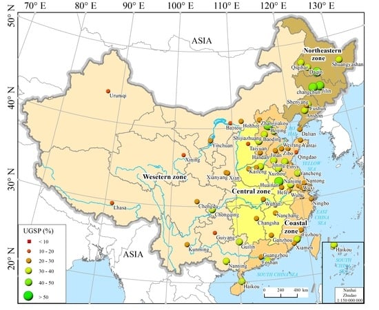
3.2. Regional Divergence of UGS Growth

The dramatic discrepancies in UGS growth among different zones of China from 2000 to 2018 are shown in Table 2. The UGS in the coastal zone experienced the most rapid growth process since 2000. The areas of UGS in the built-up coastal areas increased from 1675.77 km2 in 2000 to 4129.02 km2 in 2018, with a total increase of 2453.25 km2 (Table 3). Specifically, the major cities in the coastal zone have paid more attention to designing their forests and parks during the process of urban development. For example, a large number of urban parks, such as Xiangmi, Tanglangshan Country and Nanshan, were built in Shenzhen (Figure 4). The green space area located in Shenzhen’s built-up area increased from 156.83 km2 in 2000 to 301.87 km2 in 2018 (Table 2). Meanwhile, the proportion of UGS increased from 31.27% to 35.10% in the same period.
Compared to other zones, the northeast zone experienced the lowest increase in UGS. Although the national development strategy of the Northeast Revitalization Plan provided an opportunity for the development of UGS construction, the area of UGS in the northeastern built-up areas increased by only 461.28 km2 (Table 3).
The cities in the western and central zones also have paid more attention to the development of UGS since the beginning of the 21st century. The area of UGS in the built-up areas of the central zone increased from 318.67 km2 in 2000 to 881.63 km2 in 2018. For instance, a series of UGSs were built in Wuhan, such as Wuhan East Lake Greenway, Zhengzhou People’s Park and Changsha Yang Lake Wetland Park (Figure 4). Meanwhile, the UGS area in the western zone’s built-up areas also increased, from 415.55 km2 in 2000 to 922.15 km2 in 2018. Many UGSs were built in the western zone, such as Chengdu Tianfu Jincheng ecological park, Chongqing Nanshan Park and Yuanbo Park (Figure 4). For example, the overall goal of urban greening in Chongqing is to build a landscape garden city. The green space area of the main urban area increased from 74.94 km2 in 2000 to 115.32 km2 in 2018.
The proportions of UGS among different zones also showed tremendous differences. The UGS data in 2018 for the built-up areas in the coastal zone showed a higher proportion than that for other zones. The UGS percentage in coastal zone cities was 29.68%, which was higher than the average level of the 70 cities (28.06%). The UGS percentage in western zone cities was the lowest among the four zones. The UGS percentage in those cities was only 24.11%, which was 3.95% lower than the average value in the 70 cities. The UGS percentages of 2018 in the built-up areas of 2000, in the northeast and central zone cities, was 29.46% and 24.83%, respectively.

3.3. Improvements in Urban Greening in Newly Expanded Areas in Cities

Since the beginning of the 21st century, urban greening has become increasingly important in line with strengthening the cities’ ecological construction and urban greening infrastructure. We assessed the UGS changes in the newly urban expanded areas (UEAs) in China, from 2000 to 2018 (Figure 5). The proportion of UGS in UEAs in the selected 70 cities increased from 2000 to 2018, especially in the eastern zones. The average proportion of UGS in the UEAs of these cities in 2018 was 28.43%, which was higher than the average proportion of UGS (27.54%) in the built-up areas in 2000 (Table 4).
The proportion of UGS in the UEAs of the coastal zone increased significantly from 2000 to 2018, with an increase of 2.51% percent, from 28.24% to 30.75% (Table 4). In the same period, the proportion of UGS in the central zone increased slightly, from 23.69% in the buit-up areas of 2000, to 25.53% in the newly expanded areas, during 2000–2018. On the contrary, with the built-up areas and newly expanded areas in the northeastern and western zones, the proportions of UGS decreased by 3.71% and 2.04%, respectively.
In 2000, the proportion of UGS in the UEAs of 41 of the 70 cities was more than 2% higher than that in the built-up areas, with more than half of them distributed in the coastal and northeastern zones. Among them, the UGS percentage of 11 cities was more than 5% higher in the UEAs than it was in the built-up areas, which were mainly distributed in the coastal zone, such as Beijing, Tianjin, Baoding, Yancheng and Xuzhou.
The implementation of ecological greening projects in cities since 2000, such as the ecological corridors along the 5th ring road and Olympic Park, has significantly improved the urban greening in Beijing. For example, the road greening with a 100-m width and the large-scale urban parks along the 5th ring road were initiated to form ecological corridors, to prevent urban sprawl and improve the urban environment (Figure 6). We examined the UGS area’s increase continuously, from 46.26 km2 in 2000 to 51.95 km2 in 2018, along the 800-m buffer zones with the 5th ring road greening. Meanwhile, the area of UGS increased from 304.67 km2 in 2000 to 821.56 km2 in 2018 in Beijing. We also investigated the UGS growth in the UEAs of the western city of Lhasa during 2000–2018, with an increased area of 9.25 km2, which was a result of improvements in urban greening (Figure 6). The proportion of UGS in the UEA was 41.32% in 2018—the highest percentage among the 70 cities—which had increased by 7.29% when compared to the proportion of UGS in the built-up areas (34.03%) in 2000.

4. Discussion

4.1. Satellite Remote Sensing Plays a Pivotal Role in Monitoring UGS Change

UGS is an important component of urban land-cover types. It is always mosaicked in different functional areas, such as parks, streets and residential areas. Due to the characteristics of the UGS layout, it is difficult and time-consuming to retrieve details of UGS distribution using the statistical or human investigation method. Satellite remote sensing helps to acquire long-term and large-scale monitoring of UGS patterns and their spatiotemporal changes, which provides a pivotal data source for monitoring and assessing urban surface environments and analyzing their ecological services.
In this research, we mapped the fraction of UGS and other land-cover types. In 2018, the remotely sensed UGS area of 70 major cities was 6764.76 km2. In statistical data, the parks are viewed as management units, and impervious land-cover types, such as roads and squares, were also included and added to the area of UGS. However, the differences between UGS and the impervious areas in the parks can be delineated via remotely sensed observation, with more spatially explicit features.

4.2. The Massive Effectiveness of City Greening Since the Beginning of the 21st Century in China

A series of policies have been aimed at designing ecocities or garden cities that pay great attention to urban greening and ecological construction. In 2016, the Ministry of Housing and Urban –Rural Development published the national ecological garden city assessment criteria. According to the criteria, the urban green coverage percentage in built-up areas needed to be higher than 28% (Table 5). According to our assessment, 41 cities, including Beijing, Tianjin and Nanjing, have fully reached that goal.
The construction of urban parks has significantly addressed the lack of green space since 2000. Statistical data showed that the green coverage area of urban parks in 70 cities increased 6.62-fold between 2000 and 2017, from 504.39 km2 to 3842.26 km2. With the rapid development of cities in the coastal zone, the green coverage area of urban parks has also increased significantly. The UGS in urban parks in 32 coastal zone cities increased from 301.71 km2 in 2000 to 2278.38 km2 in 2017, with an increase of 1976.67 km2 (Figure 7). The changes in urban parks have significantly improved the recreational environment of urban residents. For example, in Changchun, more attention has been paid to the improvement of the layout of the urban landscape and leisure spaces. The green coverage area of urban parks there increased 3.43 times, from 75.04 km2 in 2000 to 332.41 km2 in 2017. A few new parks have been built, such as Changchun World Sculpture Park and Jilin Beishan Park, since 2000.

4.3. Enhancing Urban Ecosystem Services Induced by Urban Green

The theory of urban ecology has emphasized the understanding and analysis of the complexity of urban ecosystems, including the mechanism of the influence of spatial patterns and structural heterogeneity on urban ecological processes and services, as well as reduction in the negative effects of human activities [42,43,44,45].
As an important part of the urban ecosystem services, UGS plays an important role in improving the urban environment, especially in increasing soil infiltration, reducing air pollution, conserving water and beautifying the city environment [11,12,13]. UGS can also serve as an effective strategy in offsetting CO2 emissions. The appropriate area and proportion of UGS in cities can regulate the urban microclimate [25] and reduce the urban heat island [46,47]. The experimental observations found that the diurnal air temperature range (DTR) of residential building areas is significantly lower than that of parks (ΔDTRa = 2.53 ± 1.93 ºC), with a maximum difference of 3.54 ± 1.96 ºC in autumn. Therefore, UGS shows a cooling effect, especially at nighttime. These ecosystem services of urban greening are beneficial to human health, city environmental improvement, and the achievement of sustainable development goals. To promote the ecosystem services, understanding UGS patterns and dynamics is critical for guiding urban ecological planning and construction. The International Union of Forest Research Organizations established a special project team to support global cooperation and information exchanges, for improving urban ecosystem services with urban greening.

5. Conclusions

This study delineated UGS patterns and dynamics in 70 Chinese cities in 2000–2018, using the big-data analysis platform. The results show that UGS in major cities has increased significantly from 2000 to 2018 in China. The total area of UGS in these 70 cities increased from 2780.66 km2 to 6764.76 km2 during this time period. We also found that the percentage of UGS was strengthened in newly urban expanded areas, especially in the coastal zone.
However, we also found that uneven development appears in urban greening among the four zones. The proportion of UGS in the built-up areas still remained low, especially in the western zone, where the built-up areas still needed to be further optimized in order to enhance the urban greening level in future urban development.

Author Contributions

Conceptualization, W.K.; methodology, W.K., Y.D.; writing—original draft preparation, Y.D., W.K.; writing—review and editing, W.K., Y.D.; project administration, W.K.; funding acquisition, W.K. All authors have read and agreed to the published version of the manuscript.

Funding

This work was supported by the Strategic Priority Research Program A of the Chinese Academy of Sciences [XDA23100201], the Special Project of Global Space Remote Sensing Information Submission and Annual Report from the Ministry of Science and Technology [1061302600001], the Second Tibetan Plateau Scientific Expedition [2019QZKK0608], and the National Natural Science Foundation of China [41871343].

Acknowledgments

We thank the academic editor and reviewers for their constructive comments, which greatly helped us to improve the quality of this manuscript.

Conflicts of Interest

The authors declare that they have no known competing financial interests or personal relationships that could have appeared to influence the work reported in this paper.

References

  1. Bader, D.A.; Blake, R.; Grimm, A.; Hamdi, R.Q.; Kim, Y.; Horton, R.; Rosenzweig, C.; Alverson, K.; Gaffin, S.; Crane, S. Urban climate science. In Climate Change and Cities: Second Assessment Report of the Urban Climate Change Research Network (ARC3.2); Cambridge University Press: Cambridge, UK, 2018; pp. 27–60. [Google Scholar]
  2. Kabisch, N.; Strohbach, M.; Haase, D.; Kronenberge, J. Urban green space availability in European cities. Ecol. Indic. 2016, 70, 586–596. [Google Scholar] [CrossRef]
  3. Grimm, N.B.; Faeth, S.H.; Golubiewski, N.E.; Redman, C.L.; Wu, J.; Bai, X.; Briggs, J.M. Global change and the ecology of cities. Science 2008, 319, 756–760. [Google Scholar] [CrossRef] [PubMed] [Green Version]
  4. Sanchez-Rodriguez, S.; Urge-Vorsatz, D.; Barau, A.S. Sustainable development goals and climate change adaptation in cities. Nat. Clim. Chang. 2018, 8, 181–183. [Google Scholar] [CrossRef]
  5. Georgescu, M.; Morefield, P.E.; Bierwagen, B.G.; Weaver, C.P. Urban adaptation can roll back warming of emerging megapolitan regions. Proc. Natl. Acad. Sci. USA 2014, 111, 2909–2914. [Google Scholar] [CrossRef] [PubMed] [Green Version]
  6. Zhu, P.; Zhang, Y. Demand for urban forests in United States cities. Landsc. Urban Plan. 2008, 84, 293–300. [Google Scholar] [CrossRef]
  7. Sun, C.G.; Lin, T.; Zhao, Q.J.; Li, X.H.; Ye, H.; Zhang, G.Q.; Liu, X.F.; Zhao, Y. Spatial pattern of urban green spaces in a long-term compact urbanization process—A case study in China. Ecol. Indic. 2019, 96, 111–119. [Google Scholar] [CrossRef]
  8. Bierwagen, B.G.; Theobald, D.M.; Pyke, C.R.; Choate, A.; Groth, P.; Thomas, J.V.; Morefield, P. National housing and impervious surface scenarios for integrated climate impact assessments. Proc. Natl. Acad. Sci. USA 2010, 107, 20887–20892. [Google Scholar] [CrossRef] [Green Version]
  9. Matos, P.; Vieira, J.; Rocha, B.; Branquinho, C.; Pinho, P. Modeling the provision of air-quality regulation ecosystem service provided by urban green spaces using lichens as ecological indicators. Sci. Total Environ. 2019, 665, 521–530. [Google Scholar] [CrossRef] [PubMed]
  10. Selmi, W.; Weber, C.; Riviere, E.; Blond, N.; Mehdi, L.; Nowak, D. Air pollution removal by trees in public green spaces in Strasbourg city, France. Urban Urban Gree. 2016, 17, 192–201. [Google Scholar] [CrossRef] [Green Version]
  11. Nowak, D.J.; Greenfield, E.J. Tree and impervious cover in the United States. Landsc. Urban Plan. 2012, 107, 21–30. [Google Scholar] [CrossRef] [Green Version]
  12. Byomkesh, T.; Nakagoshi, N.; Dewan, A.M. Urbanization and green space dynamics in Greater Dhaka, Bangladesh. Landsc. Ecol. Enfineering 2012, 8, 45–58. [Google Scholar] [CrossRef]
  13. Wolf, K.L. Public response to the urban forest in inner-city business districts. J. Arboric. 2003, 29, 117–126. [Google Scholar]
  14. Wolch, J.R.; Byrne, J.; Newell, J.P. Urban green space, public health, and environmental justice: The challenge of making cities ‘just green enough’. Landsc. Urban Plan. 2014, 125, 234–244. [Google Scholar] [CrossRef] [Green Version]
  15. Pataki, D.E. Urban greening needs better data. Nature 2013, 502, 624. [Google Scholar] [CrossRef] [PubMed] [Green Version]
  16. Ridd, M.K. Exploring a V-I-S (vegetation-impervious surface-soil) model for urban ecosystem analysis through remote sensing: Comparative anatomy for cities. Int. J. Remote Sens. 1995, 16, 2165–2185. [Google Scholar] [CrossRef]
  17. Li, L.; Lu, D.; Kuang, W. Examining urban impervious surface distribution and its dynamic change in Hangzhou metropolis. Remote Sens. 2016, 8, 265. [Google Scholar] [CrossRef] [Green Version]
  18. Lu, D.S.; Hetrick, S.; Moran, E. Impervious surface mapping with quickbird imagery. Int. J. Remote Sens. 2011, 32, 2519–2533. [Google Scholar] [CrossRef] [PubMed] [Green Version]
  19. Lu, D.; Weng, Q. Use of impervious surface in urban land-use classification. Urban Urban Gree. 2006, 102, 146–160. [Google Scholar] [CrossRef]
  20. De la Barreraa, F.; Reyes-Paecke, S.; Banzhaf, E. Indicators for green spaces in contrasting urban settings. Ecol. Indic. 2016, 62, 212–219. [Google Scholar] [CrossRef]
  21. World Health Organization. Urban Planning, Environment and Health: From Evidence to Policy Action. 2010. 119. Available online: https://www.euro.who.int/en/home (accessed on 11 January 2020).
  22. Badiu, D.L.; Iojă, C.I.; Atroescu, M.P.; Breuste, J.; Artmann, M.; Niță, M.R.; Adinaru, S.R.G.; Hossu, C.A.; Onosea, D.A. Is urban green space per capita a valuable target to achieve cities’ sustainability goals? Romania as a case study. Ecol. Indic. 2016, 70, 53–66. [Google Scholar] [CrossRef]
  23. Kuang, W.; Chi, W.; Dengsheng, L.; Yinyin, D. A comparative analysis of megacity expansions in China and the U.S.: Patterns, rates and driving forces. Landsc. Urban Plan. 2014, 132, 121–135. [Google Scholar] [CrossRef]
  24. Cai, Y.; Chen, Y.; Tong, C. Spatiotemporal evolution of urban green space and its impact on the urban thermal environment based on remote sensing data: A case study of Fuzhou city, China. Urban. Urban Gree. 2019, 41, 333–343. [Google Scholar] [CrossRef]
  25. Sun, Y.; Xie, S.; Zhao, S. Valuing urban green spaces in mitigating climate change: A city—wide estimate of aboveground carbon stored in urban green spaces of China’s Capital. Glob. Chang. Biol. 2019, 25, 1717–1732. [Google Scholar] [CrossRef]
  26. Zhang, L.; Wang, Z.W.Z.; Da, L.D.L. Spatial characteristics of urban green space: A case study of Shanghai, China. Appl. Ecol. Environ. Res. 2019, 17, 1799–1815. [Google Scholar] [CrossRef]
  27. Huang, C.H.; Yang, J.; Jiang, P. Assessing impacts of urban form on landscape structure of urban green spaces in China using Landsat images based on Google Earth Engine. Remote Sens. 2018, 10, 1569. [Google Scholar] [CrossRef] [Green Version]
  28. Kong, F.H.; Nakagoshi, N. Spatial-temporal gradient analysis of urban green spaces in Jinan, China. Landsc. Urban Plan. 2006, 78, 147–164. [Google Scholar] [CrossRef]
  29. Zhang, X.; Guo, S.; Guan, Y.; Cai, D.; Zhang, C.; Flaus, K.; Xiao, H.; Tian, Z. Urbanization and spillover effect for three megaregions in China: Evidence from DMSP/OLS nighttime lights. Remote Sens. 2018, 10, 1888. [Google Scholar] [CrossRef] [Green Version]
  30. Zhao, J.; Chen, S.; Jiang, B.; Ren, Y.; Wang, H.; Vause, J.; Yu, H. Temporal trend of green space coverage in China and its relationship with urbanization over the last two decades. Sci. Total Environ. 2013, 442, 455–465. [Google Scholar] [CrossRef] [PubMed]
  31. Sun, J.; Wang, X.; Chen, A.; Ma, Y.; Cui, M.; Piao, S. NDVI indicated characteristics of vegetation cover change in China’s metropolises over the last three decades. Environ. Monit. Assess. 2011, 179, 1–14. [Google Scholar] [CrossRef] [PubMed]
  32. National Bureau of statistics of China. China Statistical Yearbook 2000; China Statistical Yearbook 2015; China Statistics Press: Beijing, China, 2001, 2016.
  33. Ning, J.; Liu, J.; Kuang, W.; Xu, X.; Zhang, S.; Yan, C.; Li, R.; Wu, S.; Hu, Y.; Du, G. Spatiotemporal patterns and characteristics of land-use change in China during 2010–2015. J. Geogr. Sci. 2018, 28, 547–562. [Google Scholar] [CrossRef] [Green Version]
  34. Kuang, W.; Liu, J.; Dong, J.; Chi, W.; Zhang, C. The rapid and massive urban and industrial land expansions in China between 1990 and 2010: A CLUD-based analysis of their trajectories, patterns, and drivers. Landsc. Urban Plan. 2016, 145, 21–33. [Google Scholar] [CrossRef]
  35. Liu, J.; Kuang, W.; Zhang, Z.; Xu, X.; Qin, Y.; Ning, J.; Zhou, W.; Zhang, S.; Li, R.; Yan, C. Spatiotemporal characteristics, patterns, and causes of land-use changes in China since the late 1980s. J. Geogr. Sci. 2014, 24, 195–210. [Google Scholar] [CrossRef]
  36. Kuang, W.; Yang, T.; Yan, F. Examining urban land-cover characteristics and ecological regulation during the construction of Xiong’an New District, Hebei Province, China. J. Geogr. Sci. 2018, 28, 109–123. [Google Scholar] [CrossRef] [Green Version]
  37. Dou, Y.; Kuang, W. A comparative analysis of urban impervious surface and green space and their dynamics among 318 different size cities in China in the past 25 years. Sci. Total Environ. 2019, 706, 135828. [Google Scholar] [CrossRef] [PubMed]
  38. Kuang, W.; Zhang, S.; Li, X.; Lu, D. A 30-meter resolution dataset of impervious surface area and green space fractions of China’s cities, 2000–2018. Earth Syst. Sci. Data Discuss. 2020. [Google Scholar] [CrossRef]
  39. Kuang, W. Mapping global impervious surface area and green space within urban environments. Sci. China Earth Sci. 2019, 62, 1–16. [Google Scholar] [CrossRef]
  40. Zhang, S.; Fang, C.; Kuang, W.; Sun, F. Comparison of changes in urban land use/cover and efficiency of megaregions in China from 1980 to 2015. Remote Sens. 2019, 11, 1834. [Google Scholar] [CrossRef] [Green Version]
  41. Pan, T.; Kuang, W.; Zhang, C.; Zhang, S.; Li, Z.; Chen, X. City-level comparison of urban land-cover configurations from 2000–2015 across 65 countries within the global Belt and Road. Remote Sens. 2019, 11, 1515. [Google Scholar] [CrossRef] [Green Version]
  42. McDonnell, M.J.; MacGregor-Fors, I. The ecological future of cities. Science 2016, 352, 936–938. [Google Scholar] [CrossRef]
  43. Wu, J.; Xiang, W.; Zhao, J. Urban ecology in China: Historical developments and future directions. Landsc. Urban Plan. 2014, 125, 222–233. [Google Scholar] [CrossRef]
  44. Pickett, S.; Cadenasso, M.; Grove, J.; Nilon, C.; Pouyat, R.; Zipperer, W.; Costanza, R. Urban ecological systems: Linking terrestrial ecological, physical, and socioeconomic components of metropolitan areas. Ann. Rev. Ecol. Syst. 2001, 32, 127–157. [Google Scholar] [CrossRef] [Green Version]
  45. Qiu, G.Y.; Zou, Z.; Li, X.; Li, H.; Guo, Q.; Yan, C.; Tan, S. Experimental studies on the effects of green space and evapotranspiration on urban heat island in a subtropical megacity in China. Habitat Int. 2017, 68, 30–42. [Google Scholar] [CrossRef]
  46. Hoag, H. How cities can beat the heat. Nature 2015, 524, 402–404. [Google Scholar] [CrossRef] [PubMed] [Green Version]
  47. Ca, V.; Asaeda, T.; Abu, E. Reductions in air conditioning energy caused by a nearby park. Energ. Build. 1998, 29, 83–92. [Google Scholar] [CrossRef]
Figure 1. Flow chart of data processing and analysis.
Remotesensing 12 01929 g001
Figure 2. Accuracy assessment of urban green space (UGS) fractions.
Remotesensing 12 01929 g002
Figure 3. Changes in urban green space area of China’s 70 cities during 2000–2018.
Remotesensing 12 01929 g003
Figure 4. Urban green space and park distributions in typical cities from different zones: (a) Shenzhen in the coastal zone; (b) Changchun in the northeastern zone; (c) Wuhan in the central zone; (d) Chengdu in the western zone.
Remotesensing 12 01929 g004
Figure 5. The urban green space (UGS) area changes between the built-up areas in 2000 and newly expanded areas in 2000–2018 in 70 cities.
Remotesensing 12 01929 g005
Figure 6. Landsat Images of typical cities and major parks.
Remotesensing 12 01929 g006
Figure 7. The distribution of urban parks in cities in China.
Remotesensing 12 01929 g007
Table 1. Distribution of 70 selected cities in 2018.
ZonesSelected CitiesTotal Area of Built-Up Land (km2)Urban Population (×104)
Coastal zone3213,911.7921,543.42
Northeastern zone102823.993049.79
Western zone153824.767508.64
Central zone133550.665276.78
Table 2. The 10 cities with the highest increments of urban green space (UGS) area.
CityArea of UGS in 2000 (km2)Increment of UGS in 2000–2018 (km2)Area of Built-Up Area in 2000 (km2)Increase Increment of Built-Up Area in 2000–2018 (km2)
Beijing304.67516.891034.951610.51
Nanjing88.95159.20348.70537.41
Tianjin88.64148.22565.05759.95
Shenzhen156.83145.04511.88290.54
Changchun64.07126.11297.37427.92
Guangzhou63.12125.66404.43489.57
Jinan38.18124.04241.81562.54
Shanghai155.21119.51778.06294.01
Hefei31.79117.28150.15442.97
Suzhou75.85113.50453.691154.96
Table 3. Urban green space (UGS) area changes in 70 cities in different zones during 2000–2018.
RegionArea of UGS (km2)Proportion of UGS (%)
200020182000–201820002018
Coastal zone1675.774129.022453.2528.2429.68
Central zone318.67881.63562.9623.6924.83
Western zone415.55922.15506.6025.2724.11
Northeastern zone370.67831.95461.2831.6329.46
Total2780.666764.753984.0927.5428.06
Table 4. The urban green space (UGS) changes in the built-up areas and newly expanded areas among different zones.
RegionProportion of UGS (%)
In Built-Up Areas in 2000In Newly Expanded Areas During 2000–2018In Built-Up Areas in 2018
Coastal zone28.2430.7529.68
Central zone23.6925.5324.83
Western zone25.2723.2324.11
Northeastern zone31.6327.9229.46
Average of 70 cities27.5428.4328.06
Table 5. The five cities with the highest increments of UGS area in 2000–2018.
CityUGS Area in 2018 Located in Built-Up Areas in 2000UGS Area in 2018 Located in Newly Expanded Areas in 2000–2018
Area (km2)Percentage (%)Area (km2)Percentage (%)
Beijing304.6734.03485.5444.53
Changchun64.0734.77159.9042.34
Nanjing88.9533.03156.5035.11
Harbin57.2135.12155.9748.04
Tianjin88.6423.42140.3629.77

