SAR Pancake Ice Thickness Retrieval in the Terra Nova Bay (Antarctica) during the PIPERS Expedition in Winter 2017


Abstract
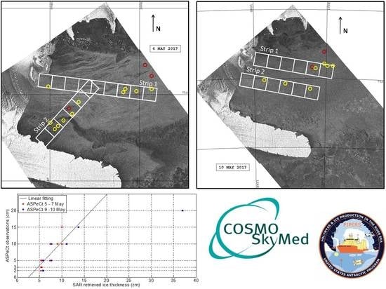
:
1. Introduction
2. Data and Methods
2.1. Synthetic Aperture Radar Dataset
2.2. The Use of SAR to Retrieve Pancake Ice Thickness
2.3. PIPERS In Situ Observations
3. Results and Discussion
4. Conclusions
Author Contributions
Funding
Acknowledgments
Conflicts of Interest
References
- Doble, M.; De Carolis, G.; Meylan, M.H.; Bidlot, J.R.; Wadhams, P. Relating wave attenuation to pancake ice thickness, using field measurements and model results. Geophys. Res. Lett. 2015, 42, 4473–4481. [Google Scholar] [CrossRef] [Green Version]
- Wadhams, P.; Aulicino, G.; Parmiggiani, F.; Persson, P.O.G.; Holt, B. Pancake Ice Thickness Mapping in the Beaufort Sea from Wave Dispersion Observed in SAR Imagery. J. Geophys. Res. Oceans 2018, 123, 2213–2237. [Google Scholar] [CrossRef]
- Parkinson, C. A 40-y record reveals gradual Antarctic sea ice increases followed by decreases at rates far exceeding the rates seen in the Arctic. Proc. Natl. Acad. Sci. USA 2019, 116, 14414–14423. [Google Scholar] [CrossRef] [PubMed] [Green Version]
- Aulicino, G.; Sansiviero, M.; Paul, S.; Cesarano, C.; Fusco, G.; Wadhams, P.; Budillon, G. A New Approach for Monitoring the Terra Nova Bay Polynya through MODIS Ice Surface Temperature Imagery and Its Validation during 2010 and 2011 Winter Seasons. Remote Sens. 2018, 10, 366. [Google Scholar] [CrossRef]
- Doble, M.J.; Wadhams, P. Dynamical contrasts between pancake and pack ice, investigated with a drifting buoy array. J. Geophys. Res. Oceans 2006, 111, C11. [Google Scholar] [CrossRef]
- Leonard, G.H.; Shen, H.H.; Ackely, S.F. Dynamic growth of a pancake ice cover. In Ice in Surface Waters, Proceedings 14th IAHR Ice Symposium, Trondheim, Norway, 14–18 June 2020; Shen, H.T., Ed.; A.A. Balkema: Rotterdam, The Netherlands, 1999; Volume 2, pp. 891–896. [Google Scholar]
- Wadhams, P.; Wilkinson, J.P. The physical properties of sea ice in the Odden ice tongue. Deep. Sea Res. Part II 1999, 46, 1275–1300. [Google Scholar] [CrossRef]
- Squire, V.A. A fresh look at how ocean waves and sea ice interact. Philos. Trans. R. Soc. Math. Phys. Eng. 2019, 376, 20170342. [Google Scholar] [CrossRef]
- Wadhams, P.; Lange, M.A.; Ackley, S.F. The Ice Thickness Distribution across the Atlantic Sector of the Antarctic Ocean in Midwinter. J. Geophys. Res. Oceans 1987, 92, 14535–14552. [Google Scholar] [CrossRef]
- Sansiviero, M.; Morales Maqueda, M.; Fusco, G.; Aulicino, G.; Flocco, D.; Budillon, G. Modelling Sea Ice Formation in the Terra Nova Bay Polynya. J. Mar. Syst. 2017, 166, 4–25. [Google Scholar] [CrossRef]
- Gordon, A.L.; Zambianchi, E.; Orsi, A.; Visbeck, M.; Giulivi, C.F.; Whitworth, T., III; Spezie, G. Energetic plumes over the western Ross Sea continental slope. Geophys. Res. Lett. 2004, 31, L21302. [Google Scholar] [CrossRef]
- Jacobs, S.S. Bottom water production and its links with the thermohaline circulation. Antarct. Sci. 2004, 16, 427–437. [Google Scholar] [CrossRef]
- Budillon, G.; Spezie, G. Thermohaline structure and variability in the Terra Nova Bay polynya, Ross Sea. Antarct. Sci. 2000, 12, 493–508. [Google Scholar] [CrossRef]
- Parmiggiani, F.; Moctezuma-Flores, M.; Wadhams, P.; Aulicino, G. Image processing for pancake ice detection and size distribution computation. Int. J. Remote Sens. 2018, 40, 3368–3383. [Google Scholar] [CrossRef]
- Alberello, A.; Onorato, M.; Bennetts, L.; Vichi, M.; Eayrs, C.; MacHutchon, K.; Toffoli, A. Brief communication: Pancake ice floe size distribution during the winter expansion of the Antarctic marginal ice zone. Cryosphere 2019, 13, 41–48. [Google Scholar] [CrossRef] [Green Version]
- Wadhams, P.; Parmiggiani, F.; de Carolis, G. The use of SAR to measure ocean wave dispersion in frazil-pancake icefields. J. Phys. Oceanogr. 2002, 32, 1721–1746. [Google Scholar] [CrossRef]
- Wadhams, P.; Parmiggiani, F.; de Carolis, G.; Desiderio, D.; Doble, M.J. SAR imaging of wave dispersion in Antarctic pancake ice and its use in measuring ice thickness. Geophys. Res. Lett. 2004, 31, L15305. [Google Scholar] [CrossRef]
- Wadhams, P.; Aulicino, G.; Parmiggiani, F.; Pignagnoli, L. Sea Ice Thickness Mapping in the Beaufort Sea Using Wave Dispersion in Pancake Ice—A Case Study with Intensive Ground Truth; ESA SP, SP-740; European Space Agency Special Publication: Paris, France, 2016. [Google Scholar]
- Hasselmann, S.; Hasselmann, K. On the nonlinear mapping of an ocean wave spectrum into a synthetic aperture radar image spectrum and its inversion. J. Geophys. Res. 1991, 96, 10713–10729. [Google Scholar] [CrossRef]
- Hasselmann, S.; Bruning, C.; Hasselmann, K.; Heimbach, P. An improved algorithm for the retrieval of ocean wave spectra from synthetic aperture radar image spectra. J. Geophys. Res. 1996, 101, 16615–16629. [Google Scholar] [CrossRef]
- Donelan, M.; Hamilton, J.; Hui, W.H. Directional spectra of wind generated waves. Philos. R. Soc. 1995, 315, 509–562. [Google Scholar] [CrossRef]
- Mastenbroek, C.; De Valk, C.F. A semiparametric algorithm to retrieve ocean wave spectra from synthetic aperture radar. J. Geophys. Res. 2000, 105, 3497–3516. [Google Scholar] [CrossRef]
- Engen, G.; Johnsen, H. SAR-ocean wave inversion using image cross spectra. IEEE Trans. Geosci. Remote Sens. 1995, 33, 1047–1056. [Google Scholar] [CrossRef]
- Keller, J.B. Gravity waves on ice-covered water. J. Geophys. Res. 1998, 103, 7663–7669. [Google Scholar] [CrossRef]
- Worby, A.P. Observing Antarctic Sea Ice: A Practical Guide for Conducting Sea Ice Observations from Vessels Operating in the Antarctic Pack Ice; A CD-ROM Produced for the Antarctic Sea Ice Processes and Climate (ASPeCt) Program of the Scientific Committee for Antarctic Research (SCAR) Global Change (GLOCHANT) Program: Tasmania, Australia, 1999. [Google Scholar]
- Thorpe, S.A. Langmuir circulation. Annu. Rev. Fluid Mech. 2004, 36, 55–79. [Google Scholar] [CrossRef]
- Plueddemann, A.J.; Smith, J.A.; Farmer, D.M.; Weller, R.A.; Crawford, W.R.; Pinkel, R.; Vagle, S.; Gnanadeskian, A. Structure and variability of Langmuir circulation during the surface waves processes program. J. Geophys. Res. 1996, 101, 3525–3543. [Google Scholar] [CrossRef]
- Morelli, S.; Parmiggiani, F. Wind over Terra Nova Bay (Antarctica) during a polynya event: Eta model simulations and satellite microwave observations. Eur. Phys. J. Plus 2013, 128, 135. [Google Scholar] [CrossRef]
- Hollands, T.; Dierking, W. Dynamics of the Terra Nova Bay Polynya: The potential of multi-sensor satellite observations. Remote Sens. Environ. 2016, 187, 30–48. [Google Scholar] [CrossRef] [Green Version]
- Roach, L.A.; Smith, M.M.; Dean, S.M. Quantifying growth of pancake sea ice floes using images from drifting buoys. J. Geophys. Res. Oceans 2018, 123, 2851–2866. [Google Scholar] [CrossRef]
- Wadhams, P.; Holt, B. Waves in Frazil and Pancake Ice and Their Detection in Seasat Synthetic Aperture Radar Imagery. J. Geophys. Res. 1991, 96, 8835–8852. [Google Scholar] [CrossRef]


© 2019 by the authors. Licensee MDPI, Basel, Switzerland. This article is an open access article distributed under the terms and conditions of the Creative Commons Attribution (CC BY) license (http://creativecommons.org/licenses/by/4.0/).
Share and Cite
Aulicino, G.; Wadhams, P.; Parmiggiani, F. SAR Pancake Ice Thickness Retrieval in the Terra Nova Bay (Antarctica) during the PIPERS Expedition in Winter 2017. Remote Sens. 2019, 11, 2510. https://doi.org/10.3390/rs11212510
Aulicino G, Wadhams P, Parmiggiani F. SAR Pancake Ice Thickness Retrieval in the Terra Nova Bay (Antarctica) during the PIPERS Expedition in Winter 2017. Remote Sensing. 2019; 11(21):2510. https://doi.org/10.3390/rs11212510
Chicago/Turabian StyleAulicino, Giuseppe, Peter Wadhams, and Flavio Parmiggiani. 2019. "SAR Pancake Ice Thickness Retrieval in the Terra Nova Bay (Antarctica) during the PIPERS Expedition in Winter 2017" Remote Sensing 11, no. 21: 2510. https://doi.org/10.3390/rs11212510