Performance Assessment of TanDEM-X DEM for Mountain Glacier Elevation Change Detection


Abstract
:1. Introduction
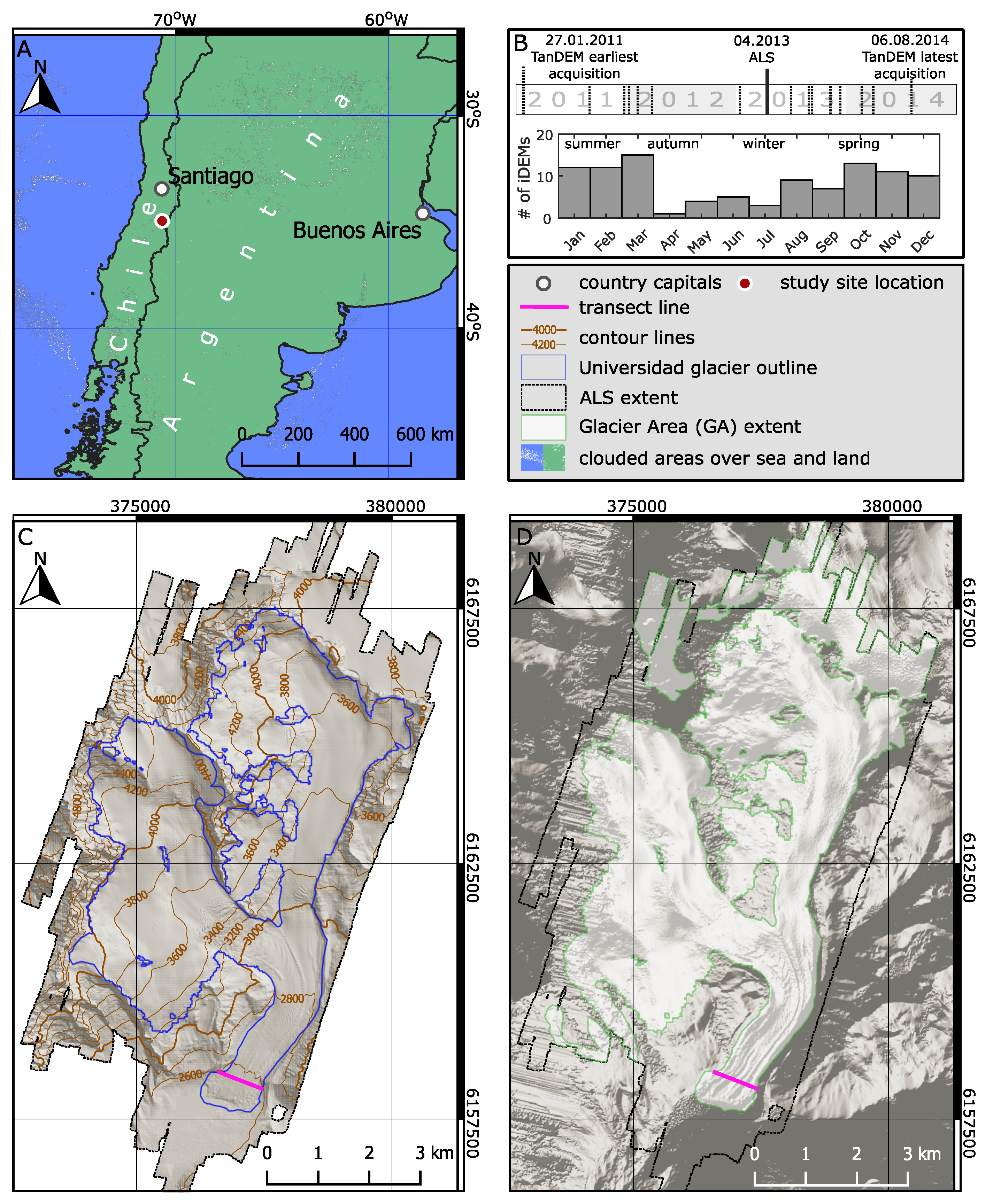
2. Study Area
3. Data and Methods
3.1. Data Used
3.2. Data Filtering
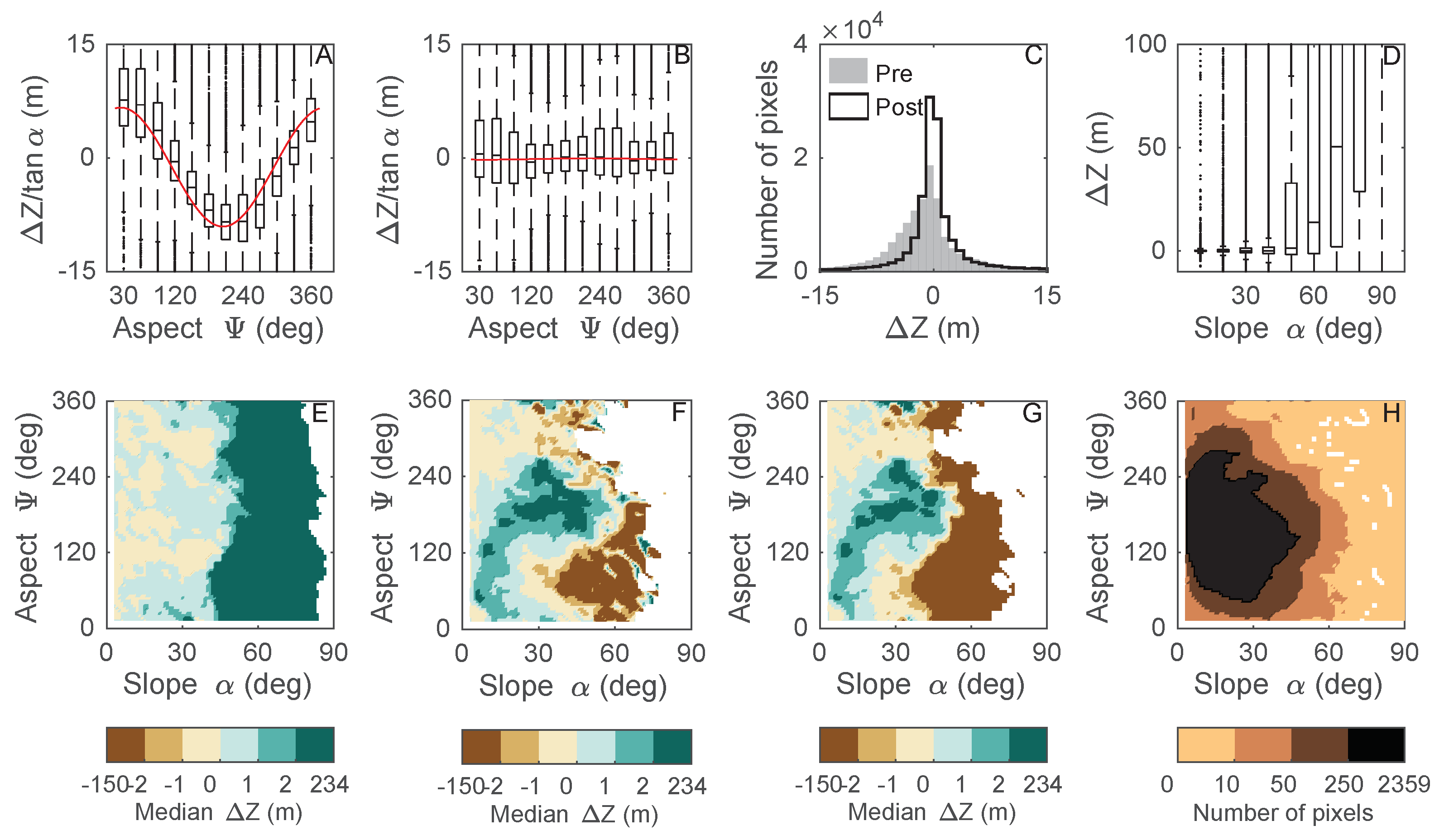
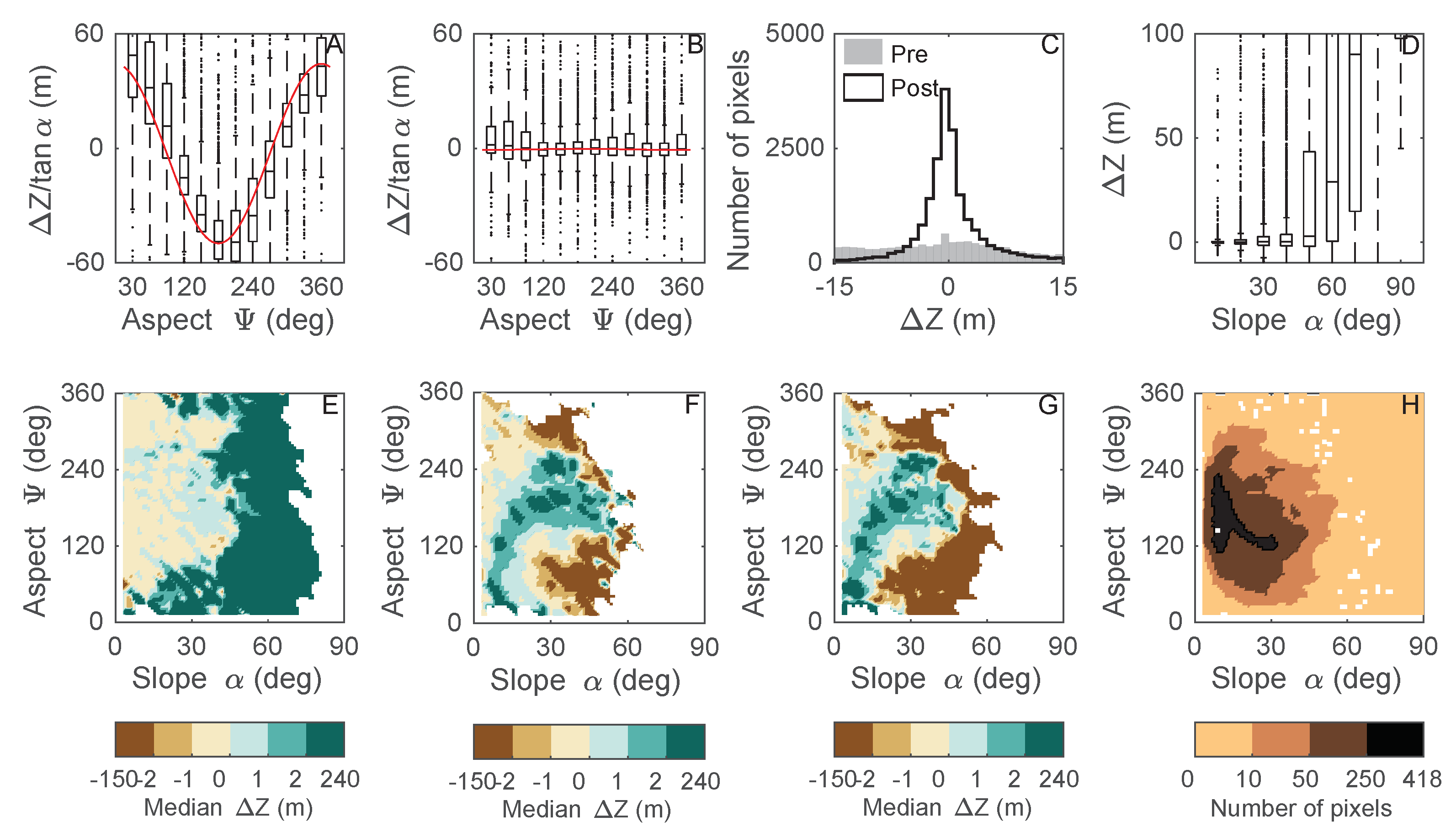
3.3. Geometric Correction
3.4. TanDEM-X DEM Systematic Error
3.5. Geodetic Mass Balance
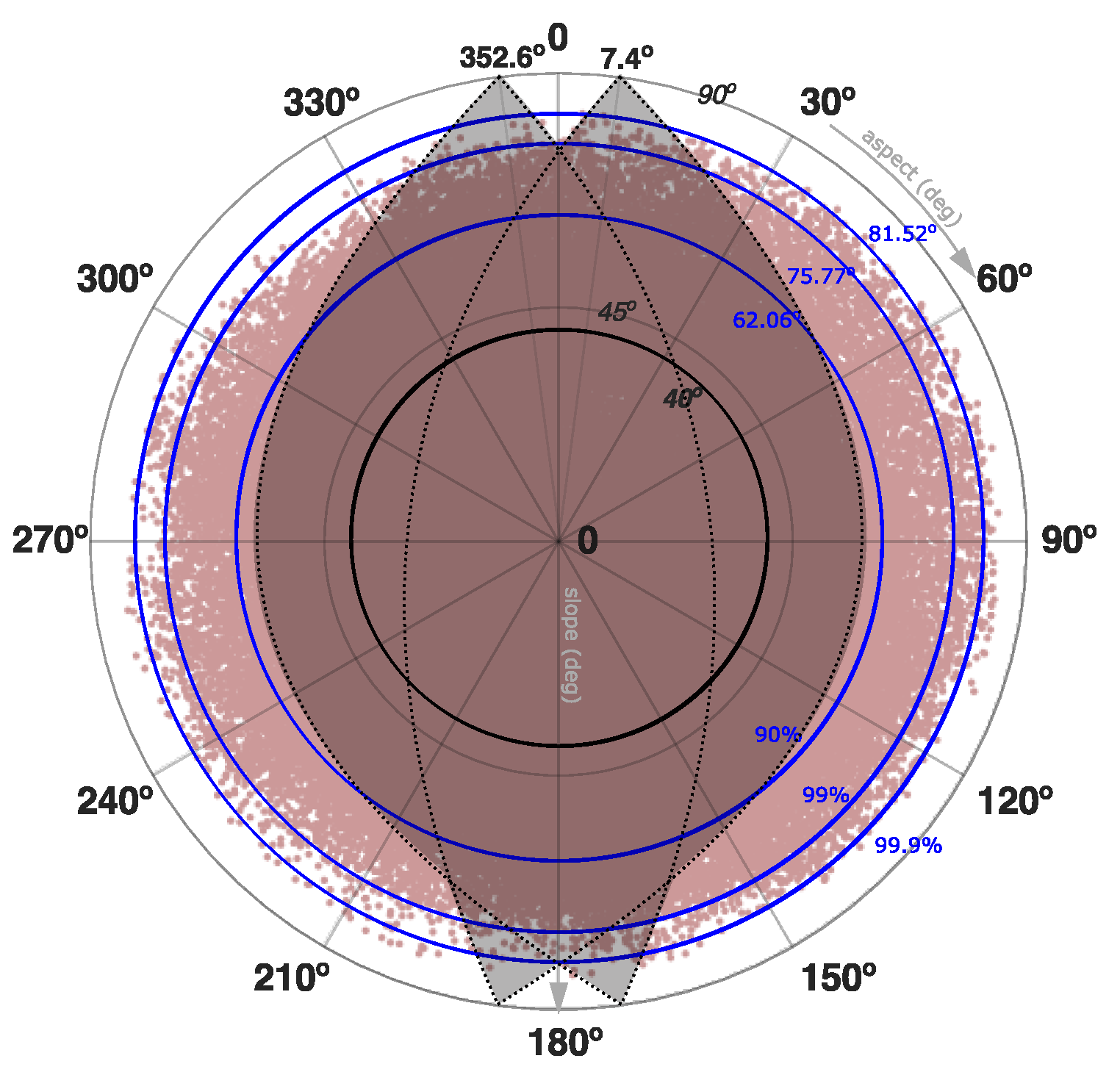
3.6. Uncertainty Measurement
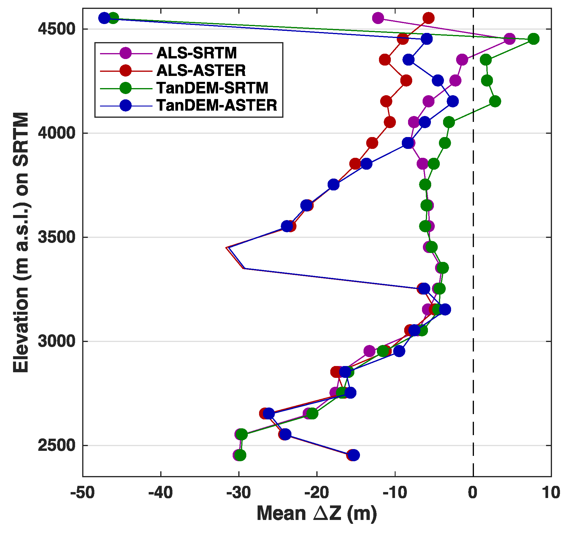
4. Results
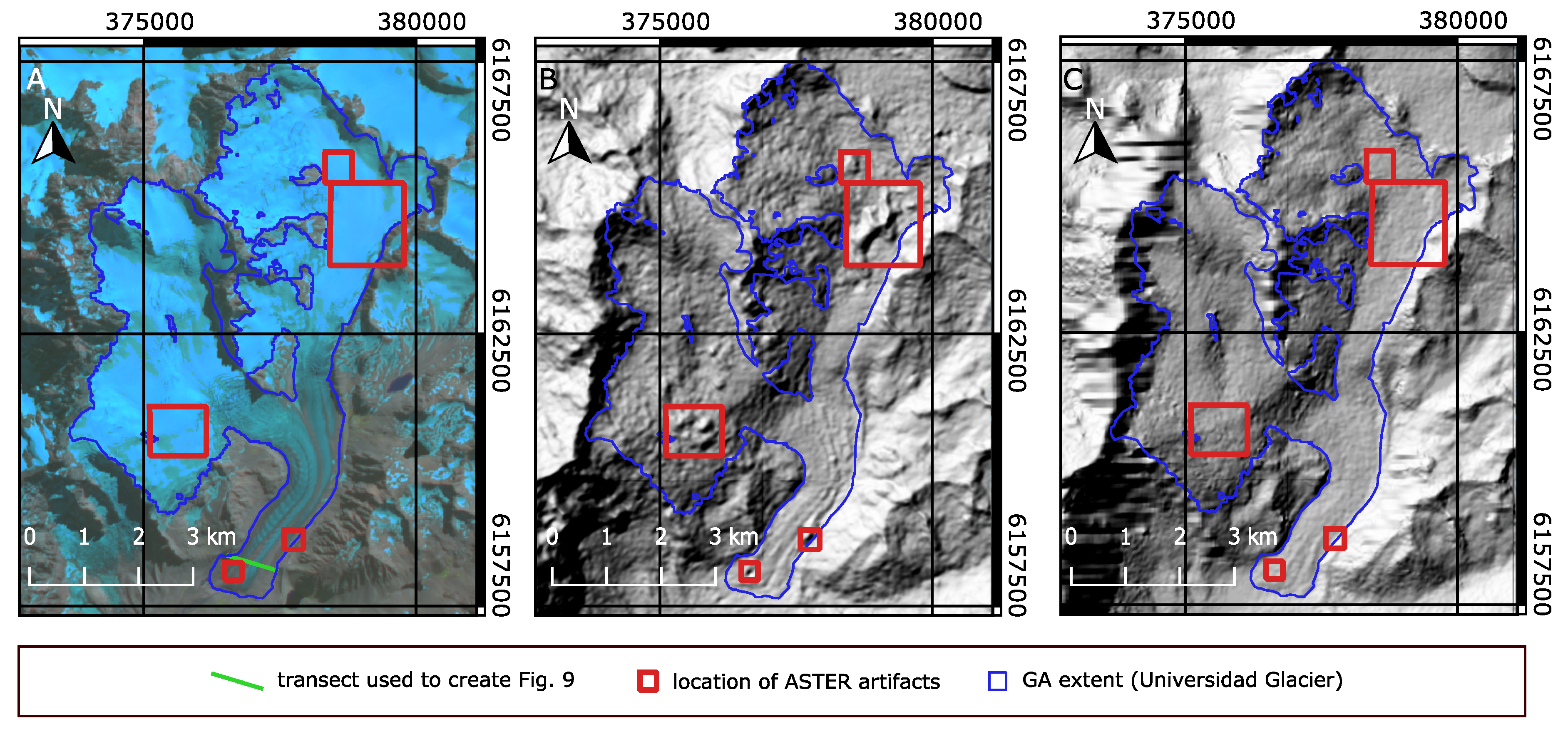
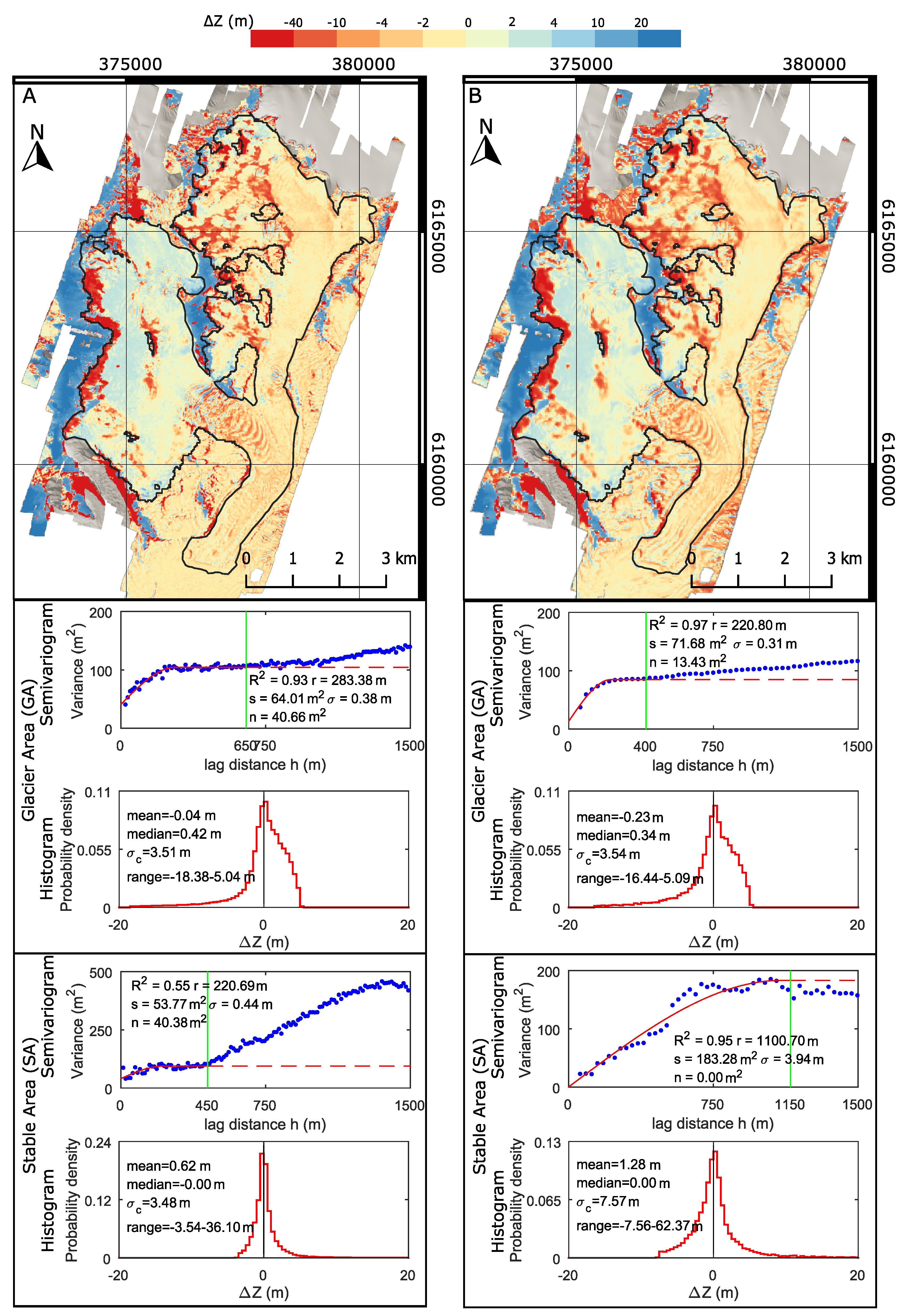
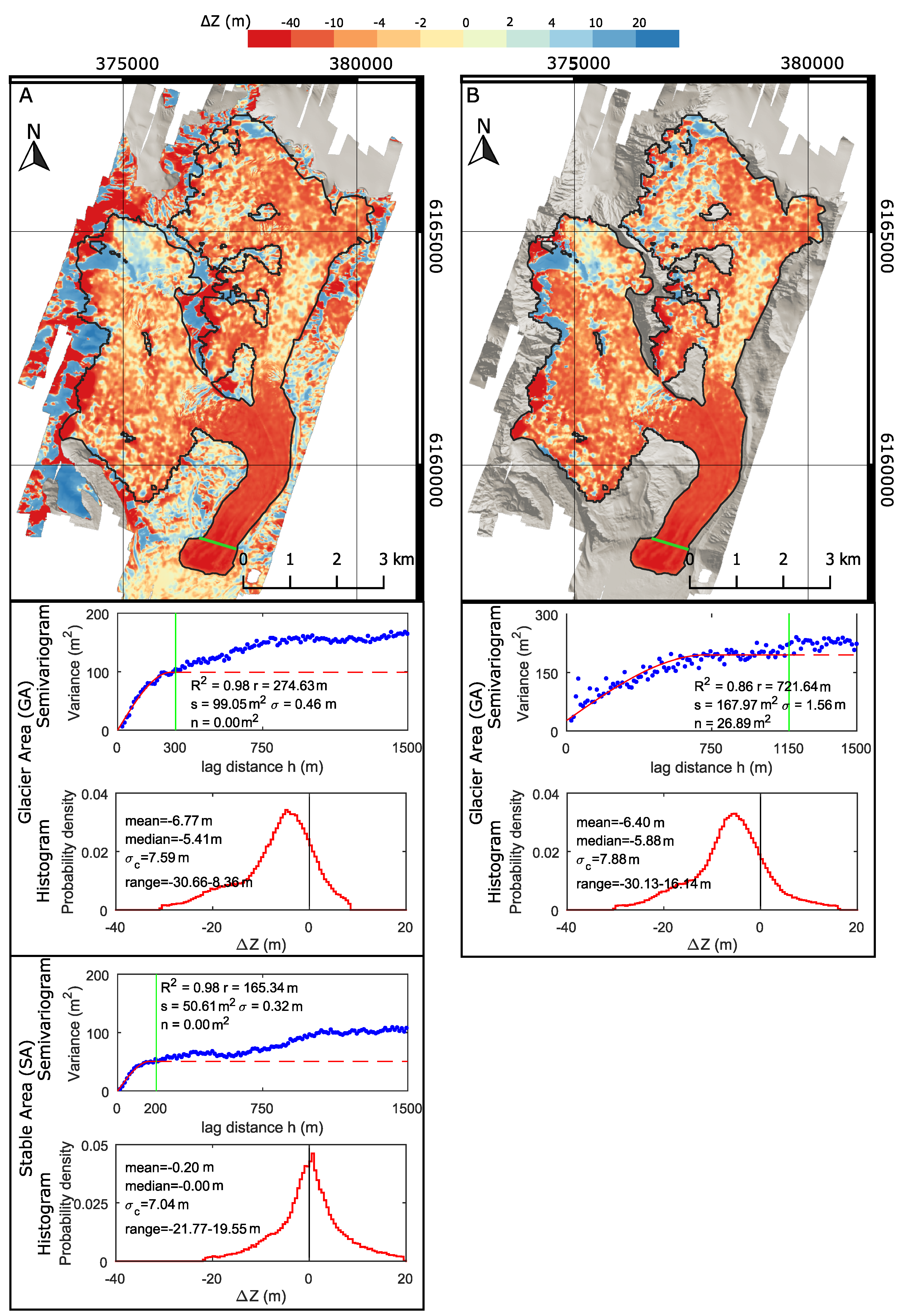
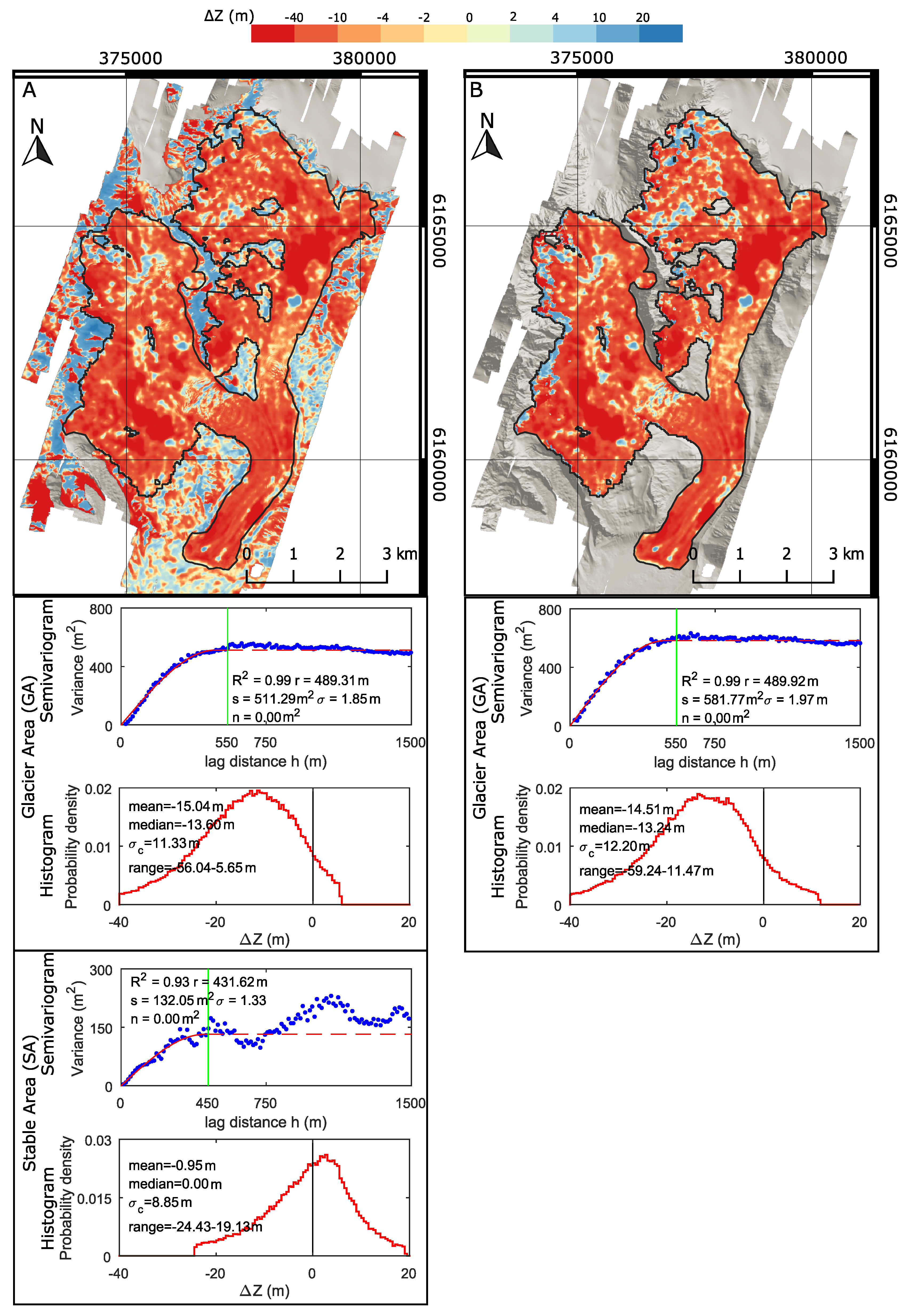
4.1. Data Correction and Quality Assessment
4.2. Glacier Geodetic Mass Balance
5. Discussion
5.1. TanDEM-X DEM Uncertainty
5.2. TanDEM-X DEM Performance
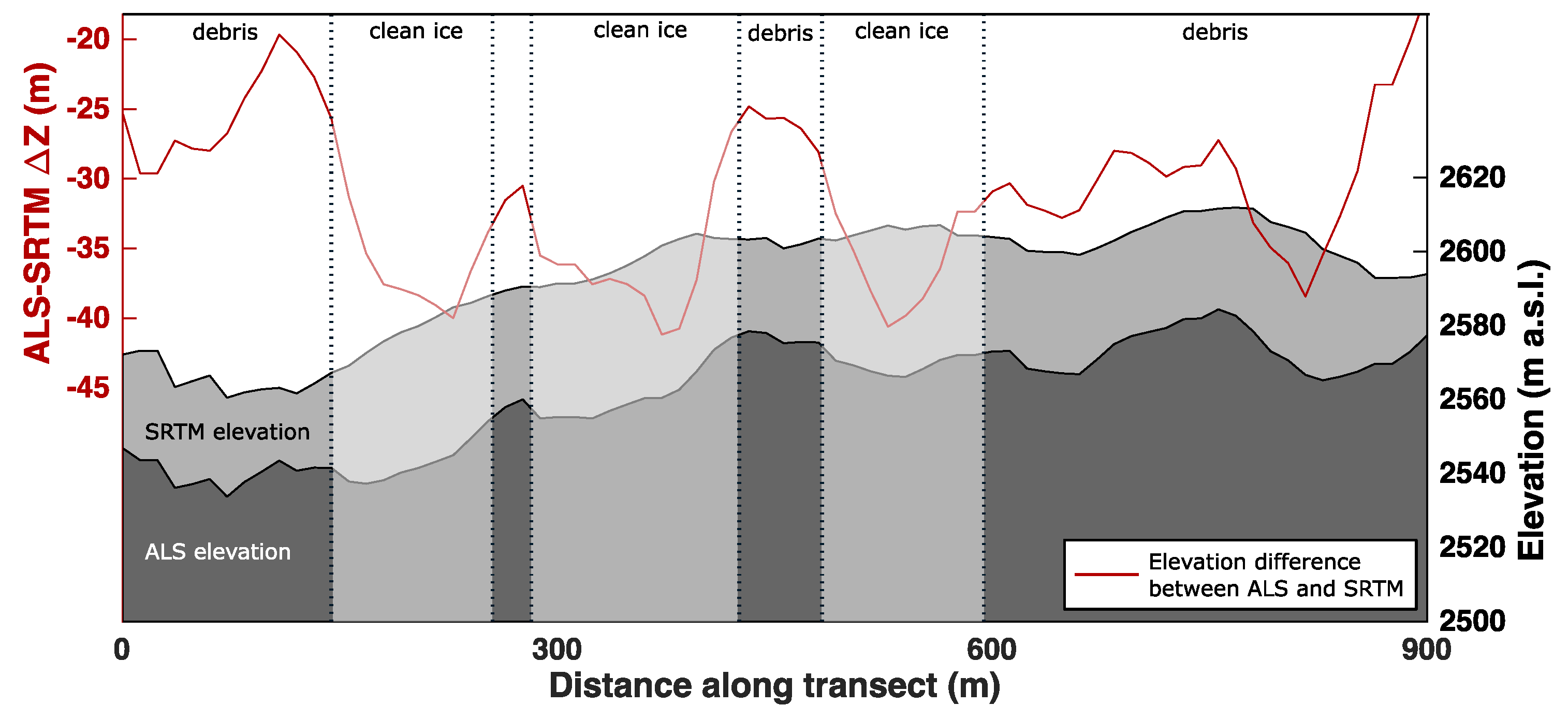
5.3. ASTER DEM Quality
5.4. Glacier Change Detection
6. Conclusions
Author Contributions
Funding
Acknowledgments
Conflicts of Interest
Abbreviations
| ALS | Aerial Laser Scanning DEM |
| ASTER | ASTER DEM V003 |
| ASTER12 | ASTER DEM V003 interpolated to 12 m resolution |
| surface slope | |
| DEM | Digital Elevation Model |
| DLR | German Aerospace Center |
| DTED-2 | Digital Terrain Elevation Data—2 standard |
| spatial resolution of a dataset | |
| Z | difference of elevation |
| GA | glacier area |
| GC | geometric correction |
| HRTI-3 | High-Resolution Terrain Information 3 standard |
| iDEM | intermediate DEM |
| JAXA | Japan Aerospace Exploration Agency |
| L | surface area of area of interest |
| LiDAR | Light Detection and Ranging |
| m w.e. | meters of water equivalent |
| n | nugget of semivariogram |
| NASA | National Aeronautics and Space Administration |
| aspect | |
| r | range of semivariogram |
| RGI | Randolph Glacier Inventory |
| s | sill of semivariogram |
| SA | stable area |
| SAHC | Slope-aspect heatmap correction |
| SAR | synthetic aperture radar |
| standard deviation | |
| uncertainty of the mean of partially spatially correlated dataset | |
| uncertainty of the mean of spatially uncorrelated dataset | |
| SRTM | SRTMv3 DEM |
| SRTM12 | SRTMv3 DEM interpolated to 12 m resolution |
| TanDEM12 | TanDEM-X DEM 12 m |
| TanDEM30 | TanDEM-X DEM 30 m |
| TanDEM30bili | TanDEM-X DEM 30 m created by bilinear interpolation of TanDEM12 |
| Z | elevation |
References
- Bojinski, S.; Verstraete, M.; Peterson, T.C.; Richter, C.; Simmons, A.; Zemp, M. The Concept of Essential Climate Variables in Support of Climate Research, Applications, and Policy. Bull. Am. Meteorol. Soc. 2014, 95, 1431–1443. [Google Scholar] [CrossRef] [Green Version]
- Immerzeel, W.W.; van Beek, L.P.H.; Bierkens, M.F.P. Climate Change Will Affect the Asian Water Towers. Science 2010, 328, 1382–1385. [Google Scholar] [CrossRef] [PubMed]
- Marzeion, B.; Champollion, N.; Haeberli, W.; Langley, K.; Leclercq, P.; Paul, F. Observation-Based Estimates of Global Glacier Mass Change and Its Contribution to Sea-Level Change. Surv. Geophys. 2016, 38, 105–130. [Google Scholar] [CrossRef] [PubMed] [Green Version]
- Hinkel, J.; Lincke, D.; Vafeidis, A.T.; Perrette, M.; Nicholls, R.J.; Tol, R.S.J.; Marzeion, B.; Fettweis, X.; Ionescu, C.; Levermann, A. Coastal flood damage and adaptation costs under 21st century sea-level rise. Proc. Natl. Acad. Sci. USA 2014, 111, 3292–3297. [Google Scholar] [CrossRef] [PubMed] [Green Version]
- Benn, D.; Evans, D.J.A. Glaciers and Glaciation, 2nd ed.; Routledge: Abingdon-on-Thames, UK, 2010. [Google Scholar]
- Bhardwaj, A.; Sam, L.; Bhardwaj, A.; Martín-Torres, F.J. LiDAR remote sensing of the cryosphere: Present applications and future prospects. Remote Sens. Environ. 2016, 177, 125–143. [Google Scholar] [CrossRef]
- Hopkinson, C.; Demuth, M.; Sitar, M.; Chasmer, L. Applications of Airborne LiDAR Mapping in Glacierised Mountainous Terrain. In Proceedings of the IGARSS 2001, Scanning Present Resolving Future, IEEE 2001 International Geoscience and Remote Sensing Symposium, Sydney, Australia, 9–13 July 2001; IEEE: Sydney, Australia, 2011. [Google Scholar] [CrossRef]
- Magnússon, E.; Belart, J.M.C.; Pálsson, F.; Ágústsson, H.; Crochet, P. Geodetic mass balance record with rigorous uncertainty estimates deduced from aerial photographs and lidar data—Case study from Drangajökull ice cap, NW Iceland. Cryosphere 2016, 10, 159–177. [Google Scholar] [CrossRef]
- Fischer, A.; Seiser, B.; Waldhuber, M.S.; Mitterer, C.; Abermann, J. Tracing glacier changes in Austria from the Little Ice Age to the present using a lidar-based high-resolution glacier inventory in Austria. Cryosphere 2015, 9, 753–766. [Google Scholar] [CrossRef] [Green Version]
- Passalacqua, P.; Belmont, P.; Staley, D.M.; Simley, J.D.; Arrowsmith, J.R.; Bode, C.A.; Crosby, C.; DeLong, S.B.; Glenn, N.F.; Kelly, S.A.; et al. Analyzing high resolution topography for advancing the understanding of mass and energy transfer through landscapes: A review. Earth-Sci. Rev. 2015, 148, 174–193. [Google Scholar] [CrossRef] [Green Version]
- Van Zyl, J.J. The Shuttle Radar Topography Mission (SRTM): A breakthrough in remote sensing of topography. Acta Astronaut. 2001, 48, 559–565. [Google Scholar] [CrossRef]
- Welch, R.; Jordan, T.; Lang, H.; Murakami, H. ASTER as a source for topographic data in the late 1990s. IEEE Trans. Geosci. Remote Sens. 1998, 36, 1282–1289. [Google Scholar] [CrossRef]
- Fujisada, H.; Urai, M.; Iwasaki, A. Technical Methodology for ASTER Global DEM. IEEE Trans. Geosci. Remote Sens. 2012, 50, 3725–3736. [Google Scholar] [CrossRef]
- Tadono, T.; Ishida, H.; Oda, F.; Naito, S.; Minakawa, K.; Iwamoto, H. Precise Global DEM Generation by ALOS PRISM. ISPRS Ann. Photogramm. Remote Sens. Spat. Inf. Sci. 2014, II-4, 71–76. [Google Scholar] [CrossRef]
- Ruiz, L.; Berthier, E.; Viale, M.; Pitte, P.; Masiokas, M.H. Recent geodetic mass balance of Monte Tronador glaciers, northern Patagonian Andes. Cryosphere 2017, 11, 619–634. [Google Scholar] [CrossRef] [Green Version]
- Willis, M.J.; Melkonian, A.K.; Pritchard, M.E.; Ramage, J.M. Ice loss rates at the Northern Patagonian Icefield derived using a decade of satellite remote sensing. Remote Sens. Environ. 2012, 117, 184–198. [Google Scholar] [CrossRef]
- Nuth, C.; Kohler, J.; König, M.; von Deschwanden, A.; Hagen, J.O.; Kääb, A.; Moholdt, G.; Pettersson, R. Decadal changes from a multi-temporal glacier inventory of Svalbard. Cryosphere 2013, 7, 1603–1621. [Google Scholar] [CrossRef] [Green Version]
- Ye, Q.; Bolch, T.; Naruse, R.; Wang, Y.; Zong, J.; Wang, Z.; Zhao, R.; Yang, D.; Kang, S. Glacier mass changes in Rongbuk catchment on Mt. Qomolangma from 1974 to 2006 based on topographic maps and ALOS PRISM data. J. Hydrol. 2015, 530, 273–280. [Google Scholar] [CrossRef]
- Krieger, G.; Moreira, A.; Fiedler, H.; Hajnsek, I.; Werner, M.; Younis, M.; Zink, M. TanDEM-X: A Satellite Formation for High-Resolution SAR Interferometry. IEEE Trans. Geosci. Remote Sens. 2007, 45, 3317–3341. [Google Scholar] [CrossRef] [Green Version]
- Rankl, M.; Braun, M. Glacier elevation and mass changes over the central Karakoram region estimated from TanDEM-X and SRTM/X-SAR digital elevation models. Ann. Glaciol. 2016, 57, 273–281. [Google Scholar] [CrossRef] [Green Version]
- Malz, P.; Meier, W.; Casassa, G.; Jaña, R.; Skvarca, P.; Braun, M. Elevation and Mass Changes of the Southern Patagonia Icefield Derived from TanDEM-X and SRTM Data. Remote Sens. 2018, 10, 188. [Google Scholar] [CrossRef]
- Rizzoli, P.; Martone, M.; Gonzalez, C.; Wecklich, C.; Tridon, D.B.; Bräutigam, B.; Bachmann, M.; Schulze, D.; Fritz, T.; Huber, M.; et al. Generation and performance assessment of the global TanDEM-X digital elevation model. ISPRS J. Photogramm. Remote Sens. 2017, 132, 119–139. [Google Scholar] [CrossRef]
- Wessel, B. TanDEM-X Ground Segment–DEM Products Specification Document; Technical Report Public Document TD-GS-PS-0021, Issue 3.1; EOC, DLR: Oberpfaffenhofen, Germany, 2016. [Google Scholar]
- Wessel, B.; Huber, M.; Wohlfart, C.; Marschalk, U.; Kosmann, D.; Roth, A. Accuracy assessment of the global TanDEM-X Digital Elevation Model with GPS data. ISPRS J. Photogramm. Remote Sens. 2018, 139, 171–182. [Google Scholar] [CrossRef]
- Grohmann, C.H. Evaluation of TanDEM-X DEMs on selected Brazilian sites: Comparison with SRTM, ASTER GDEM and ALOS AW3D30. Remote Sens. Environ. 2018, 212, 121–133. [Google Scholar] [CrossRef] [Green Version]
- Purinton, B.; Bookhagen, B. Validation of digital elevation models (DEMs) and comparison of geomorphic metrics on the southern Central Andean Plateau. Earth Surf. Dyn. 2017, 5, 211–237. [Google Scholar] [CrossRef] [Green Version]
- Kinnard, C.; MacDonell, S.; Petlicki, M.; Mendoza Martinez, C.; Abermann, J.; Urrutia, R. Mass Balance and Meteorological Conditions at Universidad Glacier, Central Chile. In Andean Hydrology; Rivera, D.A., Godoy-Faundez, A., Saavedra, M.L., Eds.; CRC Press: Boca Raton, FL, USA, 2018; Chapter 5; pp. 102–126. [Google Scholar]
- Valdés-Pineda, R.; Pizarro, R.; García-Chevesich, P.; Valdés, J.B.; Olivares, C.; Vera, M.; Balocchi, F.; Pérez, F.; Vallejos, C.; Fuentes, R.; et al. Water governance in Chile: Availability, management and climate change. J. Hydrol. 2014, 519, 2538–2567. [Google Scholar] [CrossRef]
- Bravo, C.; Loriaux, T.; Rivera, A.; Brock, B.W. Assessing glacier melt contribution to streamflow at Universidad Glacier, central Andes of Chile. Hydrol. Earth Syst. Sci. 2017, 21, 3249–3266. [Google Scholar] [CrossRef] [Green Version]
- Vuille, M.; Franquist, E.; Garreaud, R.; Casimiro, W.S.L.; Cáceres, B. Impact of the global warming hiatus on Andean temperature. J. Geophys. Res. Atmos. 2015, 120, 3745–3757. [Google Scholar] [CrossRef] [Green Version]
- NASA JPL. NASA Shuttle Radar Topography Mission Global 1 Arc Second; NASA JPL: Pasadena, CA, USA, 2013. [CrossRef]
- NASA/METI/AIST/Japan Spacesystems; U.S./Japan ASTER Science Team. ASTER On-Demand L3 DEM and Orthorectified Images, GeoTIF Format; NASA EOSDIS Land Processes DAAC, USGS Earth Resources Observation and Science (EROS) Center: Sioux Falls, SD, USA, 2007. [CrossRef]
- RIEGL Laser Measurement Systems GmbH. Airborne Laser Scanner for Full Waveform Analysis LMS-Q560; RIEGL Laser Measurement Systems GmbH: Horn, Austria, 2010. [Google Scholar]
- Karimi, N.; Farokhnia, A.; Karimi, L.; Eftekhari, M.; Ghalkhani, H. Combining optical and thermal remote sensing data for mapping debris-covered glaciers (Alamkouh Glaciers, Iran). Cold Reg. Sci. Technol. 2012, 71, 73–83. [Google Scholar] [CrossRef]
- Ackerman, S.A.; Strabala, K.I.; Menzel, W.P.; Frey, R.A.; Moeller, C.C.; Gumley, L.E. Discriminating clear sky from clouds with MODIS. J. Geophys. Res. Atmos. 1998, 103, 32141–32157. [Google Scholar] [CrossRef] [Green Version]
- LP DAAC. The Shuttle Radar Topography Mission (SRTM) Collection User Guide; NASA EOSDIS Land Processes DAAC, USGS Earth Resources Observation and Science (EROS) Center: Sioux Falls, SD, USA, 2015.
- Pfeffer, W.T.; Arendt, A.A.; Bliss, A.; Bolch, T.; Cogley, J.G.; Gardner, A.S.; Hagen, J.O.; Hock, R.; Kaser, G.; Kienholz, C.; et al. The Randolph Glacier Inventory: A globally complete inventory of glaciers. J. Glaciol. 2014, 60, 537–552. [Google Scholar] [CrossRef]
- Cogley, G.; De Angelis, H.; Miles, E.; Moelg, N.; Paul, F.; Sharp, M.; Wyatt, F. GLIMS Glacier Database; National Snow & Ice Data Center: Boulder, CO, USA, 2015. [Google Scholar] [CrossRef]
- Nuth, C.; Kääb, A. Co-registration and bias corrections of satellite elevation data sets for quantifying glacier thickness change. Cryosphere 2011, 5, 271–290. [Google Scholar] [CrossRef] [Green Version]
- Millan, R.; Dehecq, A.; Trouve, E.; Gourmelen, N.; Berthier, E. Elevation Changes and X-Band Ice and Snow Penetration Inferred from TanDEM-X Data of the Mont-Blanc Area. In Proceedings of the 2015 8th International Workshop on the Analysis of Multitemporal Remote Sensing Images, Annecy, France, 22–24 July 2015. [Google Scholar] [CrossRef]
- Düring, R.; Koudogbo, F.; Weber, M. TerraSAR-X and TanDEM-X: revolution in spaceborne radar. Int. Arch. Photogramm. Remote Sens. Spat. Inf. Sci. 2008, 37, 227–234. [Google Scholar]
- Eineder, M. Problems and solutions for InSAR digital elevation model generation of mountainous terrain. In Proceedings of the Fringe 2003 Workshop, Frascati, Italy, 1–5 December 2003; ESA: Paris, France, 2003. [Google Scholar]
- Huss, M. Density assumptions for converting geodetic glacier volume change to mass change. Cryosphere 2013, 7, 877–887. [Google Scholar] [CrossRef] [Green Version]
- Rolstad, C.; Haug, T.; Denby, B. Spatially integrated geodetic glacier mass balance and its uncertainty based on geostatistical analysis: Application to the western Svartisen ice cap, Norway. J. Glaciol. 2009, 55, 666–680. [Google Scholar] [CrossRef]
- Singh, M.K.; Gupta, R.D.; Snehmani; Bhardwaj, A.; Ganju, A. Scenario-Based Validation of Moderate Resolution DEMs Freely Available for Complex Himalayan Terrain. Pure Appl. Geophys. 2015, 173, 463–485. [Google Scholar] [CrossRef]
- Dehecq, A.; Millan, R.; Berthier, E.; Gourmelen, N.; Trouve, E.; Vionnet, V. Elevation Changes Inferred From TanDEM-X Data Over the Mont-Blanc Area: Impact of the X-Band Interferometric Bias. IEEE J. Sel. Top. Appl. Earth Obs. Remote Sens. 2016, 9, 3870–3882. [Google Scholar] [CrossRef]
- Maurer, E.; Zimmermann, S.; Mrowka, F.; Hofmann, H. Dual satellite operations in close formation flight. In Proceedings of the 12th Int. Conf. Sp. Oper. (SpaceOps 2012), Stock, Sweden, 11–12 June 2012. [Google Scholar]
- Lang, H.R.; Welch, R. ATBD-AST-08 Algorithm Theoretical Basis Document for ASTER Digital Elevation Models (Standard Product AST14); Jet Propulsion Laboratory (JPL): Pasadena, CA, USA, 1999.
- Barcaza, G.; Nussbaumer, S.U.; Tapia, G.; Valdés, J.; García, J.L.; Videla, Y.; Albornoz, A.; Arias, V. Glacier inventory and recent glacier variations in the Andes of Chile, South America. Ann. Glaciol. 2017, 58, 166–180. [Google Scholar] [CrossRef] [Green Version]
- Bolch, T. Debris. In Encycl. Snow, Ice Glaciers (Encyclopedia Earth Sci. Ser.); Singh, V.P., Singh, P., Haritashya, U.K., Eds.; Springer: Dordrecht, The Netherlands, 2011; ISBN 9789048126415. [Google Scholar]
- Wilson, R.; Mernild, S.H.; Malmros, J.K.; Bravo, C.; Carrión, D. Surface velocity fluctuations for Glaciar Universidad, central Chile, between 1967 and 2015. J. Glaciol. 2016, 62, 847–860. [Google Scholar] [CrossRef]
- Pino, P.; Iglesias, V.; Garreaud, R.; Cortés, S.; Canals, M.; Folch, W.; Burgos, S.; Levy, K.; Naeher, L.P.; Steenland, K. Chile Confronts its Environmental Health Future After 25 Years of Accelerated Growth. Ann. Glob. Heal. 2015, 81, 354. [Google Scholar] [CrossRef]
- Cabré, M.F.; Solman, S.; Núñez, M. Regional climate change scenarios over southern South America for future climate (2080–2099) using the MM5 Model. Mean, interannual variability and uncertainties. Atmósfera 2016, 29, 35–60. [Google Scholar] [CrossRef]


| Name | Source | Based on | Original Res. | Res. Used | Time |
|---|---|---|---|---|---|
| ALS DEM (ALS) | This study | Aerial laser scan (ALS) | 1 m | 12 m 30 m | April 2013 |
| TanDEM-X DEM (TanDEM) | DLR | SAR X-band | 12/30 m | 12 m 30 m | Average of 2011–2014 |
| SRTM v3 DEM (SRTM) | NASA [31] | SAR C-Band void-filled | 30 m | 12 m 30 m | 11–22 February 2000 |
| ASTER DEM V003 (ASTER) | NASA | IR stereopairs | 30 m | 12 m 30 m | 9 April 2003 |
| Dataset | GC Shift Vector (m) | Median Z (m) | LE90 (m) | |||||
|---|---|---|---|---|---|---|---|---|
| X | Y | Z | Initial | Final | < 11.31 | 11.31 < < 40 | > 40 | |
| TanDEM12 | 7.55 | 3.33 | −0.32 | −0.11 ± 101.89 | 0.02 ± 3.48 | 1.09 | 16.50 | 215.29 |
| TanDEM30bili | 6.01 | 2.01 | −0.27 | −0.20 ± 100.37 | 0.02 ± 6.36 | 1.35 | 22.73 | 221.98 |
| TanDEM30 | 51.25 | 1.05 | −0.22 | 2.13 ± 106.32 | −0.08 ± 7.57 | 2.03 | 26.77 | 229.65 |
| ASTER | 52.86 | 21.68 | −3.65 | −6.45 ± 61.63 | 0.22 ± 8.90 | 15.59 | 24.54 | 82.82 |
| SRTM | 52.54 | −3.29 | −5.82 | −10.61 ± 53.51 | −0.11 ± 7.31 | 12.56 | 24.88 | 123.04 |
| ASTER 12bili | 16.37 | 23.70 | −4.30 | −4.49 ± 57.65 | 0.41 ± 8.85 | 11.14 | 24.68 | 81.22 |
| SRTM 12bili | 4.23 | −0.39 | −6.16 | −6.30 ± 52.52 | 0.06 ± 7.04 | 6.17 | 24.75 | 120.63 |
| Subtracted Datasets | Years | Resolution (m) | Mean Mean Z (m) ± | Ice Loss (m w.e.) ± | Ice Loss Rate (m w.e.a) ± | |
|---|---|---|---|---|---|---|
| ALS-TanDEM12 | 2013–2013 | 12 | −0.04 | ± 0.45 | −0.04 ± 0.38 | - |
| ALS-SRTM12 | 2013–2000 | 12 | −6.77 | ± 0.34 | −5.75 ± 0.28 | −0.44 ± 0.08 |
| ALS-ASTER12 | 2013–2003 | 12 | −15.04 | ± 1.33 | −12.79 ± 1.13 | −1.28 ± 0.36 |
| TanDEM12-SRTM12 | 2013–2000 | 12 | −6.40 | ± 0.54 | −5.44 ± 0.46 | −0.42 ± 0.13 |
| TanDEM12-ASTER12 | 2013–2003 | 12 | −14.51 | ± 1.40 | −12.33 ± 1.19 | −1.23 ± 0.38 |
| ALS-TanDEM30bili | 2013–2013 | 30 | −1.05 | ± 3.40 | −0.89 ± 2.89 | - |
| ALS-TanDEM30 | 2013–2013 | 30 | −0.23 | ± 3.94 | −0.19 ± 3.35 | - |
| ALS-SRTM | 2013–2000 | 30 | −6.99 | ± 0.42 | −5.94 ± 0.36 | −0.46 ± 0.10 |
| TanDEM30-SRTM | 2013–2000 | 30 | −6.49 | ± 3.96 | −5.52 ± 3.37 | −0.42 ± 0.93 |
| TanDEM30bili-SRTM | 2013–2000 | 30 | −5.66 | ± 3.42 | −4.81 ± 2.91 | −0.37 ± 0.81 |
| ALS-ASTER | 2013–2003 | 30 | −15.71 | ± 1.07 | −13.36 ± 0.91 | −1.34 ± 0.29 |
| TanDEM30-ASTER | 2013–2003 | 30 | −15.02 | ± 4.08 | −12.77 ± 3.47 | −1.28 ± 1.10 |
| TanDEM30bili-ASTER | 2013–2003 | 30 | −14.13 | ± 3.65 | −12.01 ± 3.10 | −1.20 ± 0.98 |
© 2019 by the authors. Licensee MDPI, Basel, Switzerland. This article is an open access article distributed under the terms and conditions of the Creative Commons Attribution (CC BY) license (http://creativecommons.org/licenses/by/4.0/).
Share and Cite
Podgórski, J.; Kinnard, C.; Pętlicki, M.; Urrutia, R. Performance Assessment of TanDEM-X DEM for Mountain Glacier Elevation Change Detection. Remote Sens. 2019, 11, 187. https://doi.org/10.3390/rs11020187
Podgórski J, Kinnard C, Pętlicki M, Urrutia R. Performance Assessment of TanDEM-X DEM for Mountain Glacier Elevation Change Detection. Remote Sensing. 2019; 11(2):187. https://doi.org/10.3390/rs11020187
Chicago/Turabian StylePodgórski, Julian, Christophe Kinnard, Michał Pętlicki, and Roberto Urrutia. 2019. "Performance Assessment of TanDEM-X DEM for Mountain Glacier Elevation Change Detection" Remote Sensing 11, no. 2: 187. https://doi.org/10.3390/rs11020187