1. Introduction
The construction of dry stone walls is part of a millennium-long process of building and modelling steep hillsides that is of fundamental importance for Italy, since mountains and hills makes up for 77% of the Italian territory, while slopes experience continual erosion. Dry stone walls and terraces are not to be protected merely in aesthetic terms: the European Landscape Convention [
1] does not justify the value of a landscape on such grounds, but rather for its environmental, cultural and economic value, in order to achieve a sustainable integrated development [
2]. In the agricultural territory, dry stone walls and terraces, and other features such as hedgerows, rows of trees, monumental trees, springs or historic canals, are considered to be the subject of legal protection and valorisation through the Recommendations of the Council of Ministers to the Member States [
3]. Any proposal for the recovery and valorisation of the terraced landscapes carried out by farmers and policy makers must begin by overcoming a narrow definition of terrace. Indeed, the current role of terraces has moved beyond its pure agricultural or morphological function to that of the management and control of quality territories in which different sustainability functions, namely economic-productive, environmental-ecological and historical-cultural, come together [
4].
Historically, the terraces represented a complex system for managing slope dynamics (from the conservation of the soil to the triple function of runoff, drainage and the collection of rainwater,
etc.). The deterioration of a hillside, artificially in equilibrium, leads to the reactivation of erosion phenomena [
5], the loss of fertile soil and the increase or disordered evolution of runoff [
6]. With the abandonment of the terraces and the cessation of maintenance works on the drainage systems, the soils begin to be saturated and the hydrogeological processes previously controlled by human intervention tend to restore the original profiles of the slopes [
7,
8]. The dry stone walls are important to reduce slope length, trap erosion sediments and reduce soil erosion [
9]. In the Land Use/cover area Frame statistical Survey (LUCAS) performed every three years by Eurostat, the surveyors are indenting the stone walls. According to Van der Zanden
et al. [
10], Italy has one of the highest density of dry stone walls together with other Mediterranean countries. Those results allowed to model for first time ever the contribution of stone walls in reducing erosion at European scale [
11]. Thus, the abandonment of the terraced agricultural systems has a negative impact on the landscape, both in terms of the disappearance of traditional agronomic practices and because it places the sustainable development of the Mediterranean hill and mountain environments at risk [
12,
13,
14].
In recent years, the progressive recognition of the value of the terraced agricultural systems has led to the proliferation of protective actions at national and community levels. These are envisioned both in the National Strategic Plan for Rural Development 2007–2013 [
15] and in the standards of Good Agricultural and Environmental Conditions (GAECs) (EC Regulation No. 73/2009) [
16], which prohibits the elimination of the same and includes them among the obligatory elements to be conserved. In this respect, specific references for the maintenance of the existing terraces, as identifying elements of the landscape with protective and ecological functions, are present in Standards 1.3 and 4.4 of the Ministerial Decree 30125/2009 [
17]. The National Register of the Historic Rural Landscape [
18], according to the UNESCO-sCBD Florence Declaration of 2014 [
19], also recognized the agronomic and historic-cultural value of the terraces as well as their important expression of the biocultural diversity associated to the rural territory. In order to allow the restoration of terraces the Italian Government has modified the Forest Law n. 227 of 2001 [
20], stating that abandoned terraces covered by forest vegetation can no longer be considered as forest. Therefore, forests growing on abandoned terraces can be removed. At regional level, the implementation of the EC Regulation took place through Regional Council Decree No. 183/2012 [
21], which through the Rural Development Plan 2007–2013 [
22] provided for funding measures for operations of ordinary and extraordinary maintenance of the artefacts, in addition to the new construction of dry stone walls. Also the Rural Development Plan 2014–2020 [
23] provides support for investments for the conservation and restoration of landscape features, such as dry stone walls, terraced systems,
etc. These actions are also intended as land improvements to increase the profitability and competitiveness of farms.
Within the framework of implementation of EC policies for the protection and valorisation of the rural landscape, the aim of the study regards the typological characterization of the agricultural terraced systems in the Tuscany Region. The qualitative characterisation of the water and soil conservation systems investigated was carried out through the analysis of the construction features of the dry stone walls. More specifically, the final results concerned considerations on the construction type, dimensional parameters, building materials and state of conservation of the dry stone walls of the most representative terraced systems at regional scale. The measurement of these parameters must be made through direct observation, because the application of new technologies (e.g., lidar, airborne remote sensing, etc.) are unable to describe analytically the qualitative parameters of these complex systems. Based on the data collected it will be possible to provide assessments regarding the degree of accessibility, drainage systems and complementary elements of the terraced system, in order to achieve functional evaluations on the state of conservation of the sample areas. Finally, the authors will suggest some types of maintenance operations, technically and economically sustainable, as a practice for mitigating the risk of hydrogeological instability and ensuring the profitability of agricultural production.
2. Data Survey and Compilation
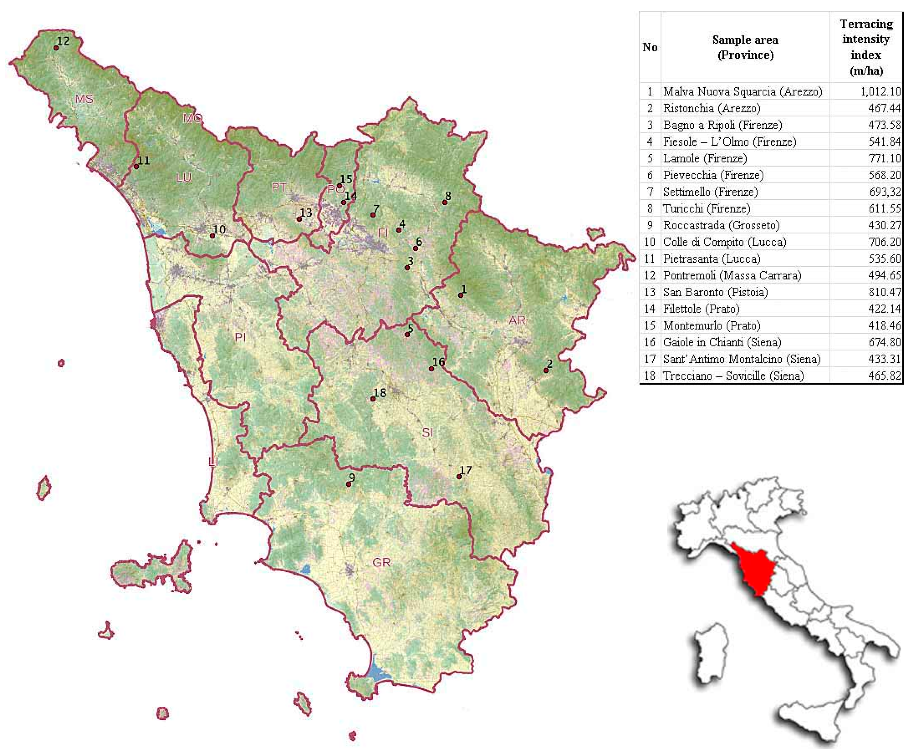
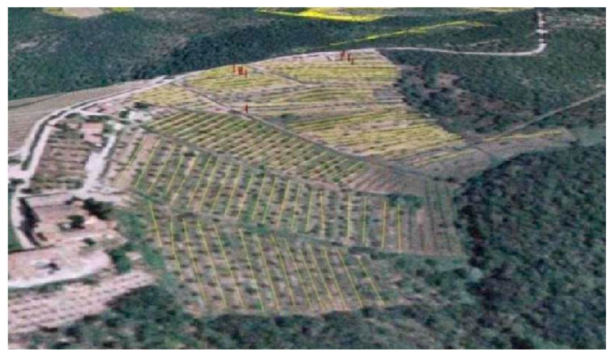
Based on the results of a previous study aimed at quantitatively defining the terraced agricultural systems in the Tuscany Region and identifying the areas that were more relevant in terms of the intensity of terracing [
24], this research intends to offer a characterisation of the dry stone walls of the sample areas through accurate surveys. In view of the complexity of a census of the whole regional territory, the analysis of 18 sample areas with terracing intensity index greater than 400 m/ha was essential (
Figure 1). The intensity index can be defined as the ratio between the linear extension of the dry stone walls and the surface of 1 ha. It should also be specified that the objective was the characterisation of the agricultural terraced areas to be subjected to the GAECs.
Figure 1.
Location of the sample areas.
Figure 1.
Location of the sample areas.
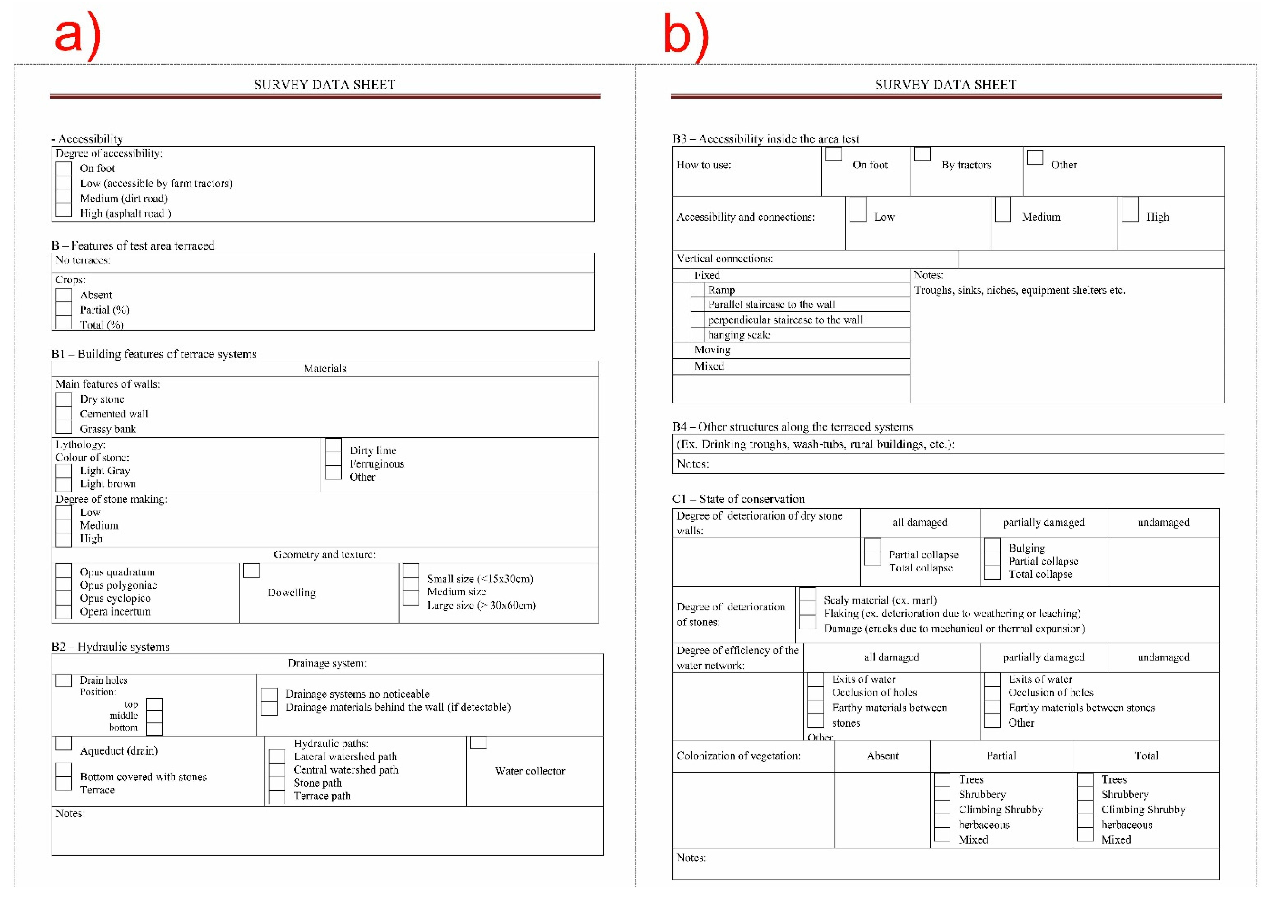
The typological analysis of the sample areas involved the definition of a simple survey data sheet to define the quality features of the terraced systems, with special reference to the dimensional parameters of the dry stone walls, the hydraulic system, the state of conservation, the use of the terraced area, etc. The definition of a descriptive survey data sheet was necessary to simplify and standardize the data collected by the operators during technical surveys.
The survey data sheet was divided into two sections: the first with details at a territorial scale (1:25,000) and the second on a detailed scale (1:5000) referring to the individual sample area. The first part included information relating to the identification of the area: province, municipality, location, landscape regional contexts extracted from the Piano d’Indirizzo Territoriale 2005–2010 (PIT—Territorial Policy Plan) of Tuscany [
25], geographical coordinates and an extract of the geo-referenced Topographic Map (1:25,000) of Italy (1994), showing the location of the survey area. Additional references concerned details of the extension of the terraced surface, the altitude, slope, aspect and lithology and the land use with reference to the Corine Land Cover 2006 IV level (1:100,000, minimum mappable unit equal to 25 ha) [
26].
The second part of the survey data sheet (
Figure 2a), based on the features of the sample area, included information regarding the degree of accessibility (A) and the land use (B); after this, the building features of the dry stone walls were analysed (B1), recording the lithology, the colour of stone, the degree of working, the geometry and size of the stone materials; finally, details relating to the hydraulic system were recorded (drainage systems, ditch,
etc.) (B2).
Figure 2.
(a) Information (A, B, B1, B2) referring to the sample area; (b) Information (B3, C1) referring to the sample area.
Figure 2.
(a) Information (A, B, B1, B2) referring to the sample area; (b) Information (B3, C1) referring to the sample area.
Accessibility within the sample area was also assessed (methods of utilisation and transit, connections,
etc.) (B3). Later, considerations relating to the general state of conservation of the system were made (C1), comprising an overall appraisal of the degree of alteration of the walls, the stone elements, the efficiency of the hydraulic system and the presence of infestive vegetable colonisation (
Figure 2b).
The last part of the survey data sheet, in addition to recording the functional characteristics of the wall, was also used as a technical notebook for recording the instrumental measurements relating to the terraced strip and the section of wall under investigation. More specifically, the instrumental survey concerned measuring the dimensions of the terraced strips (width) and of the external faces of the dry stone wall (height and inclination).
These data were obtained using instruments like GPS, total station, laser distance meter, digital inclinometer and other accessory instruments. The survey of the parameters described above was carried out in one section for five walls of each sample area, in order to analyse any specific features existing in the surveyed area. Five dry stone walls were randomly selected for each area.
The data processing was carried out using special technical drawing software (Computer Aided Design—CAD); this software allowed the 2D graphic representation of the hillsides of the sample areas. As a first step, the elaboration envisaged the use of contour lines for the creation of the section, after which the data acquired were used to draw the profile of the slope and of the terracing.
The software was also used to edit the stones composing the external face of the wall; the photos of each section were imported into CAD and then edited to calculate the dimensions of the stone elements.
3. Results and Discussion
Instrumental measurements and qualitative analyses were carried out in 16 sample areas to determine the typological characteristics and the state of conservation of the individual artefacts. Surveys in the sample areas (9) and (15) have not been performed, because they were in state of functional and productive abandonment.
Analysis of the dimensional parameters of the dry stone walls concerned in particular measurements relating to the width of the terraced strips and the height and inclination of the external wall face of the artefacts (
Table 1).
Table 1.
Analysis of the dimensional parameters.
Table 1.
Analysis of the dimensional parameters.
| Area No. | Parameters | Wall No. 1 | Wall No. 2 | Wall No. 3 | Wall No. 4 | Wall No. 5 | Aver. Strip Width | Aver. Wall Height | Aver. Wall Inclination |
|---|
| 1 | strip width (m) | 9.99 | 7.99 | 7.59 | 7.40 | 7.60 | 8.11 | | |
| height (m) | 1.39 | 1.57 | 0.89 | 1.55 | 0.89 | | 1.26 | |
| inclination (°) | 83.9 | 83.4 | 81.2 | 75.8 | 79.2 | | | 80.7 |
| 2 | strip width (m) | 15.68 | 9.58 | 4.49 | 5.17 | 9.99 | 8.98 | | |
| height (m) | 1.29 | 1.89 | 1.17 | 1.05 | 1.10 | | 1.30 | |
| inclination (°) | 67.5 | 84.5 | 78.1 | 72.8 | 85.7 | | | 77.72 |
| 3 | strip width (m) | 9.73 | 9.23 | 9.17 | 11.03 | 10.52 | 9.94 | | |
| height (m) | 1.09 | 1.28 | 1.19 | 0.50 | 1.17 | | 1.05 | |
| inclination (°) | 83.60 | 79.80 | 83.70 | 83.00 | 82.14 | | | 82.45 |
| 4 | strip width (m) | 23.26 | 26.27 | 11.25 | 5.56 | 25.43 | 18.35 | | |
| height (m) | 1.68 | 1.54 | 1.70 | 2.10 | 1.89 | | 1.78 | |
| inclination (°) | 80.70 | 83.10 | 86.00 | 86.70 | 83.24 | | | 83.95 |
| 5 | strip width (m) | 13.00 | 14.80 | 21.00 | 5.50 | 6.50 | 12.16 | | |
| height (m) | 0.65 | 1.50 | 1.70 | 2.30 | 1.74 | | 1.58 | |
| inclination (°) | 79.00 | 67.00 | 80.00 | 75.00 | 68.20 | | | 73.84 |
| 6 | strip width (m) | 2.75 | 9.99 | 9.66 | 10.25 | 11.25 | 8.78 | | |
| height (m) | 1.20 | 2.18 | 1.26 | 1.98 | 1.63 | | 1.65 | |
| inclination (°) | 88.00 | 82.50 | 75.00 | 82.00 | 77.96 | | | 81.09 |
| 7 | strip width (m) | 9.33 | 8.95 | 10.21 | 10.39 | 9.80 | 9.74 | | |
| height (m) | 1.94 | 2.24 | 1.64 | 1.78 | 1.72 | | 1.86 | |
| inclination (°) | 80.90 | 82.00 | 86.30 | 82.30 | 81.25 | | | 82.55 |
| 8 | strip width (m) | 30.40 | 19.98 | 28.41 | 21.00 | 24.38 | 24.83 | | |
| height (m) | 1.90 | 1.57 | 1.37 | 1.55 | 2.05 | | 1.69 | |
| inclination (°) | 86.00 | 79.70 | 76.00 | 83.20 | 79.80 | | | 80.94 |
| 10 | strip width (m) | 3.74 | 4.11 | 3.58 | 5.23 | 4.78 | 4.29 | | |
| height (m) | 1.11 | 0.85 | 1.24 | 0.96 | 1.17 | | 1.07 | |
| inclination (°) | 68.30 | 72.30 | 74.60 | 70.80 | 69.54 | | | 71.11 |
| 11 | strip width (m) | 3.80 | 4.61 | 4.96 | 5.11 | 4.38 | 4.57 | | |
| height (m) | 1.24 | 1.36 | 1.48 | 1.28 | 1.55 | | 1.38 | |
| inclination (°) | 81.50 | 77.30 | 74.25 | 80.50 | 79.70 | | | 78.65 |
| 12 | strip width (m) | 7.40 | 5.50 | 7.77 | 3.18 | 5.90 | 5.95 | | |
| height (m) | 1.00 | 1.40 | 1.10 | 1.20 | 1.55 | | 1.25 | |
| inclination (°) | 70.00 | 65.50 | 67.00 | 70.80 | 61.00 | | | 66.86 |
| 13 | strip width (m) | 4.07 | 4.04 | 3.67 | 4.11 | 4.71 | 4.12 | | |
| height (m) | 0.90 | 1.18 | 1.08 | 0.90 | 0.97 | | 1.01 | |
| inclination (°) | 86.8 | 80.1 | 79.3 | 84.4 | 77.1 | | | 81.54 |
| 14 | strip width (m) | 11.16 | 14.23 | 13.12 | 19.24 | 11.48 | 13.85 | | |
| height (m) | 1.80 | 1.79 | 1.39 | 0.99 | 2.37 | | 1.67 | |
| inclination (°) | 88.50 | 84.00 | 83.70 | 80.30 | 80.70 | | | 83.44 |
| 16 | strip width (m) | 5.97 | 5.86 | 6.08 | 5.58 | 6.24 | 5.95 | | |
| height (m) | 0.97 | 0.89 | 1.19 | 1.38 | 1.23 | | 1.13 | |
| inclination (°) | 77.00 | 82.70 | 83.00 | 79.80 | 71.00 | | | 78.70 |
| 17 | strip width (m) | 13.34 | 17.54 | 9.14 | 19.27 | 15.32 | 14.92 | | |
| height (m) | 0.95 | 1.16 | 1.44 | 1.00 | 0.96 | | 1.10 | |
| inclination (°) | 72.2 | 75.5 | 73.1 | 87.5 | 74.4 | | | 76.54 |
| 18 | strip width (m) | 13.01 | 9.54 | 17.09 | 24.93 | 3.80 | 13.67 | | |
| height (m) | 1.39 | 1.35 | 0.99 | 1.56 | 1.76 | | 1.41 | |
| inclination (°) | 83.20 | 74.50 | 80.40 | 77.30 | 78.60 | | | 78.80 |
| Average Value | 10.51 | 1.39 | 78.68 |
The processing of the data yielded an average width of the terraced strips of 10.51 m with a maximum of around 30 m and a minimum of 2.74 m. Analogous studies carried out on the terraced systems of Monte Pisano [
27] indicate average strip width values of around 2 m up to a maximum of 10 m. Similar situations can be observed in Liguria [
28] with average dimensions of around 3–4 m and maximum values of 10–12 m and on the Costa Viola in Calabria [
29,
30] with an average strip width of 2–3 m.
Data relating to wall height have yielded average values of 1.39 m maximum of 2.37 m and minimum of 0.5 m. In Veneto [
31], over 65% of the walls have an average height of between 1 and 2 m while 12% are less than a meter in height. In Liguria and Calabria, heights of between 1.8 and 2 m are more frequently recorded. Following this, from the data relating to the inclination it was possible to observe that the average value works out at around 78.68°, with maximum values of around 88.5° and minimum of 61°.
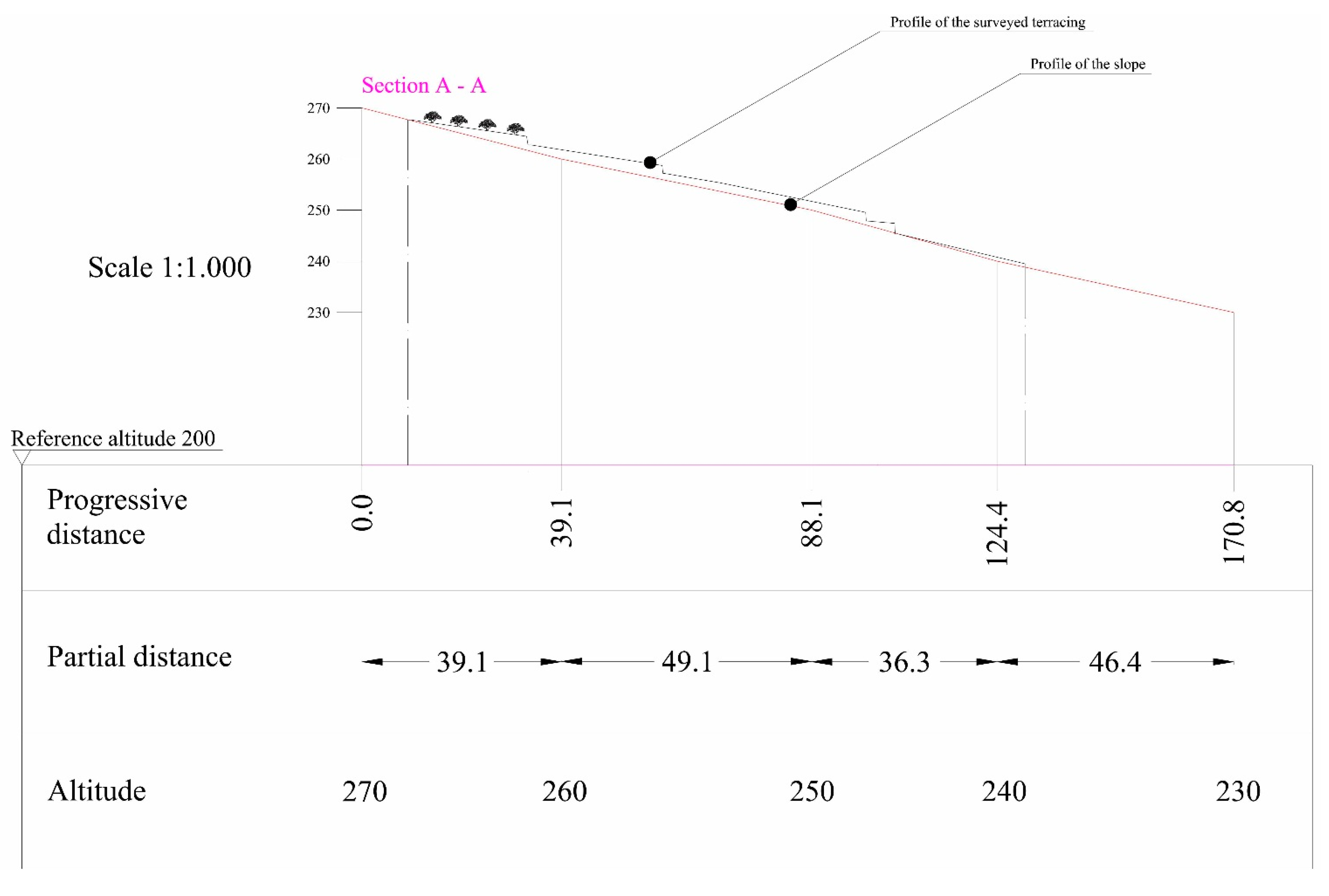
The processing of the recorded data was carried out using special technical drawing software (Computer Aided Design—CAD); this software allowed the 2D graphic representation of the profiles of the sample areas. As a first step, the elaboration envisaged the use of contour lines for the creation of the relief section, after which the data acquired were used to draw the profile of the slope and of the terracing (
Figure 3).
The surveyed artefacts are of the dry stone wall type, all level with the ground, that is with the top of the wall at the same level as the cultivated surface. The walls included in the census featured a single wall face: only in two cases were double-face walls recorded, Settimello (7) and Filettole (14). In the case of the area (7) the double wall-face serves to mark out a path for passage between the terraces, whereas in the area (14) it is used for the creation of a terrace strip of about 2 m.
Figure 3.
2D graphic representation of the survey section of the sample area (4).
Figure 3.
2D graphic representation of the survey section of the sample area (4).
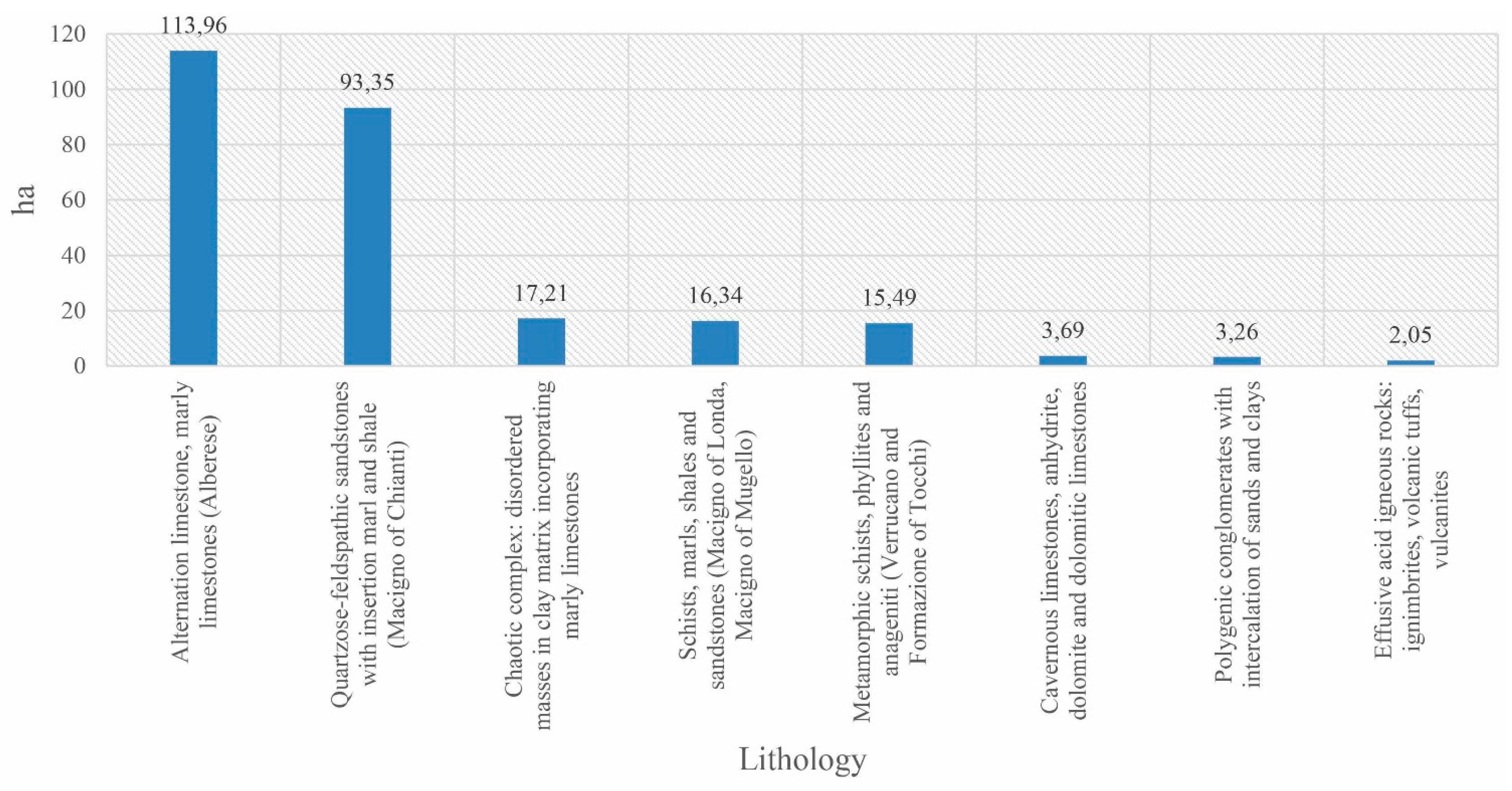
The dry stone walls are heterogeneous in terms of the stone materials used, the degree of working of the stones, size,
etc. In this regard, the terraced areas were analysed on the basis of the lithology, since this parameter affects both the shape and the arrangement of the stone elements, defining the geometry of the walls. The most frequently lithic materials of the terraced systems investigated belongs to the limestones (e.g., Alberese) and the quartzose-feldspathic sandstones (e.g., Macigno del Chianti), respectively accounting for around 114 and 93 ha of surface covered with these materials (
Figure 4). This parameter also influences the type of deterioration of the stone material represented by cracking (a phenomenon prevalent in the distribution area of sandstone) or chipping (a form of deterioration present in the dry stone walls made of limestone), as well as affecting the degree of working of the stones and hence the costs of restoration of the stone terrace walls.
Figure 4.
Distribution of the lithological classes in the sample terraced areas.
Figure 4.
Distribution of the lithological classes in the sample terraced areas.
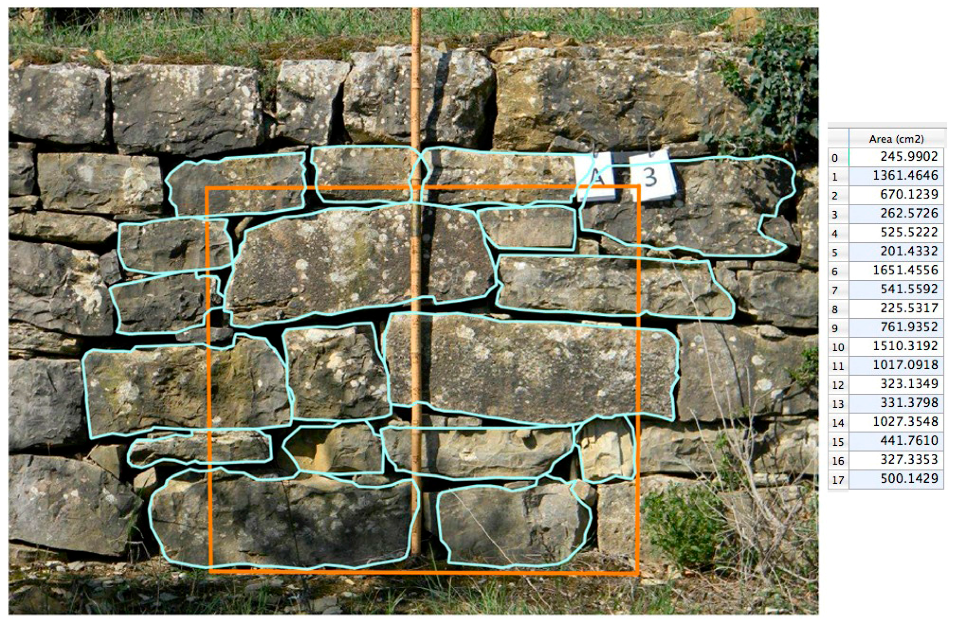
The subsequent analysis carried out on the lithic material most characteristic (Alberese) of the sample areas concerned the digitisation in vector format of 1149 stones relating to a surface area of about 1 m
2 for each area (
Figure 5), in order to calculate the size values and the respective dimensions. The stone elements completely included in the area and those partially included were calculated. It has been possible to observe that the average size of the stones is about 390 cm
2; in the literature, stones of these dimensions are considered small [
27]. It should also be clarified that in the processing phase stones with a surface of less than 30 cm
2 were ruled out, since these can be identified as plugging or filling elements rather than being structural. The distribution frequency of the sizes of the stones confirmed the prevalence of elements (807) of small dimensions 30–450 cm
2, followed by those of medium size (326) belonging to the class 450–1800 cm
2 and finally by just a few (16) large elements >1800 cm
2. It was decided to use these categories in accordance with other studies carried out in Italy [
27].
The arrangement of the terraces was conceived as a spatial distribution connected with a geometrical or non-geometrical order. In the literature, the geometrical arrangement is defined as: parallel continuous, parallel zigzag and non-parallel. From this study, it emerged that the terraces have a parallel continuous arrangement (86%), sometimes interrupted by ditch or by horizontal or vertical connection elements such as agricultural roads, steps or ramps (
Figure 6); a distribution of a non-parallel geometric type was found only in the area (17).
Figure 5.
Digitisation and dimensions of the stones of a wall face.
Figure 5.
Digitisation and dimensions of the stones of a wall face.
Figure 6.
3D processing with parallel continuous arrangement of the terraces.
Figure 6.
3D processing with parallel continuous arrangement of the terraces.
The most common arrangements of the stone material can be referred to the geometries of
Opus poligonale and
Opus incerta (
Figure 7), with only slightly worked stones arranged in such a way as to be placed as close as possible to each other. Two stone terrace walls displaying
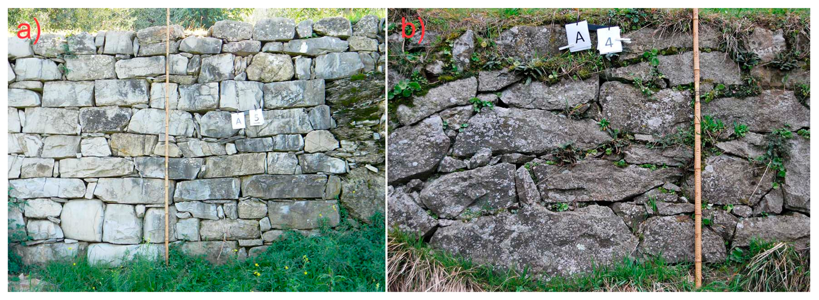
filaretto, with intensively worked stones, were also identified in the terraced agricultural areas (4) and (6); on the other hand, in the area (18), the dry stone walls are made using rounded pieces of limestone that are hardly worked at all.
Figure 7.
(a) Parallel continuous geometrical type arranged in the form of Opus poligonale in area (14); (b) Parallel continuous geometrical type arranged in the form of Opus incerta in area (13).
Figure 7.
(a) Parallel continuous geometrical type arranged in the form of Opus poligonale in area (14); (b) Parallel continuous geometrical type arranged in the form of Opus incerta in area (13).
Assessments of the hydraulic system of the sample areas led to the conclusion that it is hard to detect it, due to the high level of damage, despite that fact that residual portions of the principal and accessory hydraulic elements have survived (ditch, drain outlets, rear of wall drainage material, etc.). Regarding the level of efficiency in the ditch, these are affected by a high degree of functional deterioration due both to the blockage of the conduits by collapsed stonework and to the dense herbaceous and shrub vegetation present. In the sample area (11), it was noted that the ditch had been functionally rehabilitated using pipes instead of stone slabs in vibration-compressed concrete. The accessory hydraulic components were not detected in any of the areas, so that the water runoff continues to be associated with the inclination of the terraced strip.
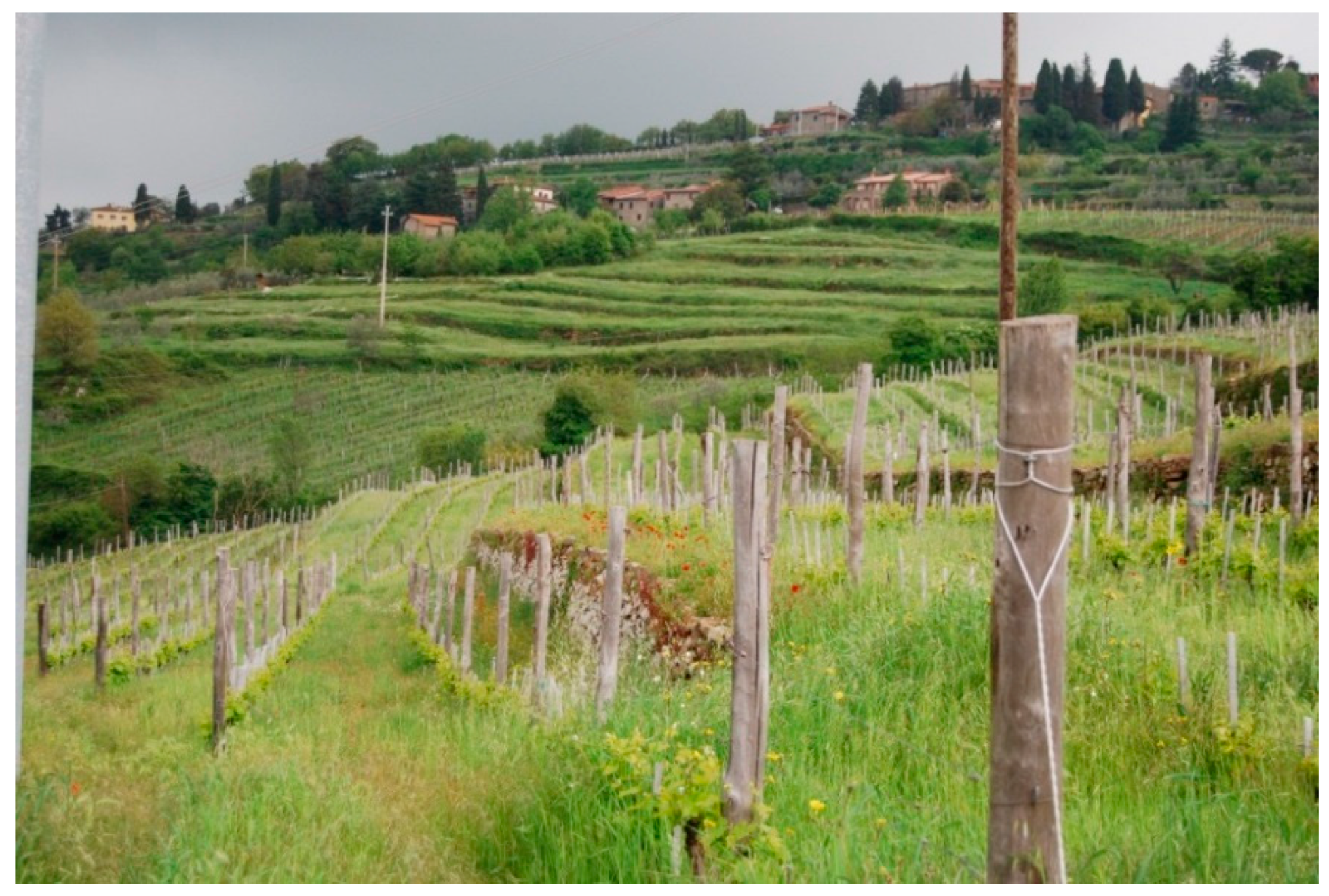
Regarding the type of access to the areas, these can be identified as farm tracks arranged sideways or centrally to the terraced system. The continuing existence of country roads allows farm vehicles to access all the areas except for site (6), (10), (11), (13) and (17), which are accessible only by foot. At present, the mechanisation of the terraced areas seems to be an important requisite for the design of new implantations (e.g., the vineyards of area (5)), in order to optimise production without jeopardising the typical elements of the historic agricultural terraced landscape (
Figure 8).
The overall degree of internal accessibility of the sampled units appears to be high. Other service connections currently present consist of steps on the wall face, parallel steps set up against the walls and perpendicular steps in variable states of conservation. The presence of a terraced system entirely accessible by connecting ramps between the strips should be noted in area (10).
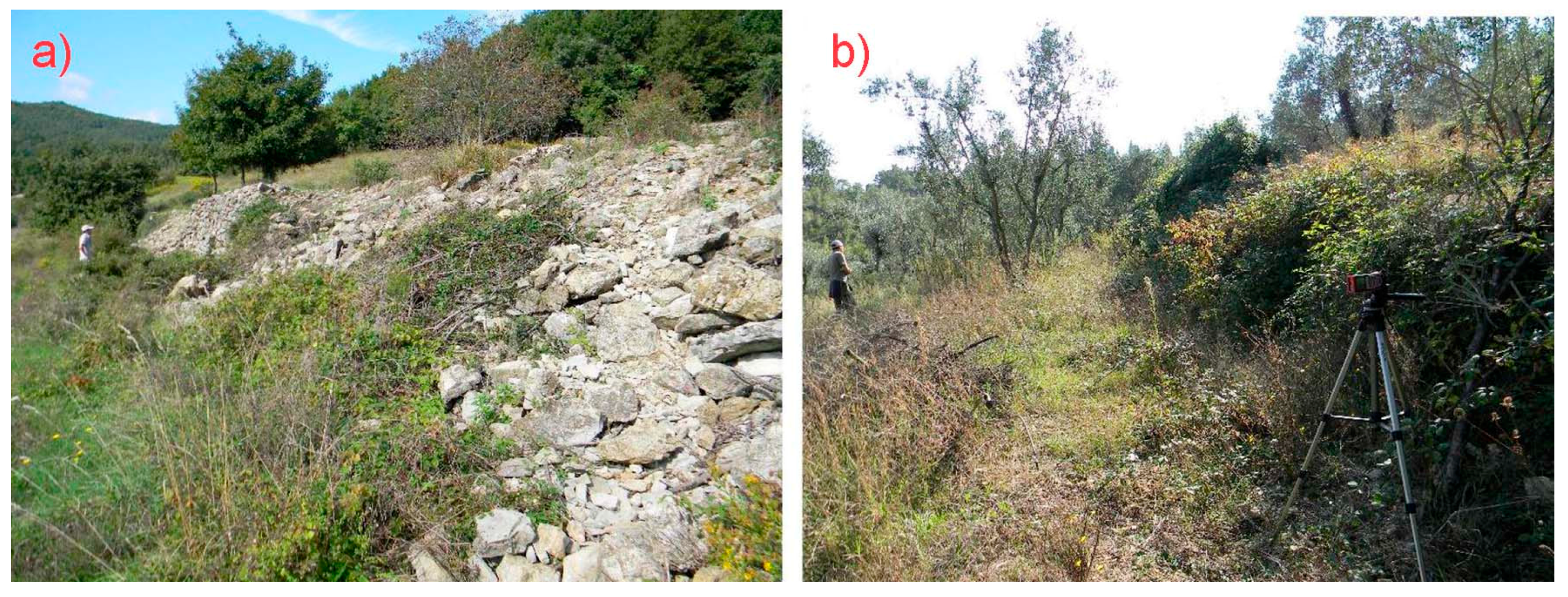
The overall analysis of the sample areas has allowed to make certain observations regarding the state of conservation of the dry stone walls, recording in all the areas localised structural alterations (small and medium landslides) of the construction system (
Figure 9). In such areas the types of instability can be related to phenomena of collapse and/or warping, due to abandonment of the farming activities and consequently to the lack of ordinary maintenance of the dry stone walls. These phenomena have been reported in area (9) and (15), where the wall structures and the components of the hydraulic systems are completely damaged. The insufficient drainage of the retaining dry stone walls can trigger soil saturation and erosion due to the rising up of groundwater table, the uncontrolled runoff (overflow and lateral infiltration of the water),
etc.
Figure 8.
Implantation of new vineyards designed for mechanised viticulture on traditional terraced systems.
Figure 8.
Implantation of new vineyards designed for mechanised viticulture on traditional terraced systems.
Figure 9.
(a) Clear signs of functional abandon of the dry stone walls shown by collapses in area (15); (b) Presence of shrub colonization in area (3).
Figure 9.
(a) Clear signs of functional abandon of the dry stone walls shown by collapses in area (15); (b) Presence of shrub colonization in area (3).
Sometimes, even where the overall structure proves to be in good condition, the presence of infestive shrub vegetation was observed, which has a negative influence on the structural conservation of the dry stone walls increasing the overall instability of the wall itself. Other exogenous causes making dry stone walls vulnerable to erosion can regard to the repeated passage of wild fauna, particularly abundant since the last 10 years in all rural areas, hilly and mountainous, of Tuscany.
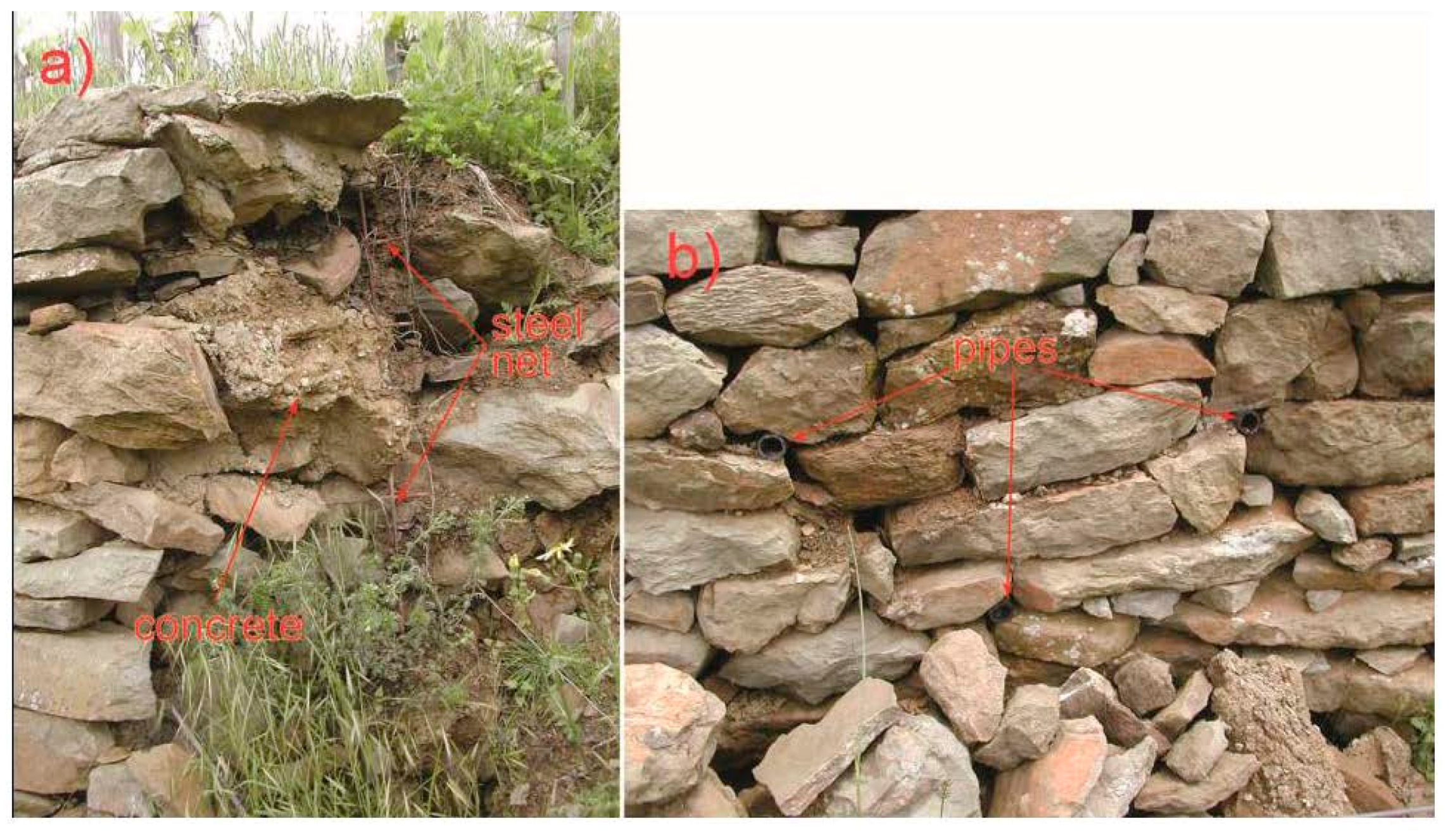
In certain situations of particular criticality, operations for the restoration of the dry stone walls were observed, carried out by using binding materials to connect the stones each other and by using electro welded wire mesh upstream of the wall face (
Figure 10). In other cases, the use of concrete has regarded the insertion of the plugging elements between the stones to repair specific instabilities of the wall structure. In both cases, the original features of the dry stone walls have been lost, leading to a gradual waterproofing of the terracing. Other technical shortcomings referring to design faults in the hydraulic systems were also observed. It is evident that the incorrect restoration of the walls reduces the drainage capacity of them leading to deformations and collapses.
Figure 10.
(a) Example of a restoration using electro welded wire and concrete behind the dry stone wall; (b) Since the drainage is obstructed by the concrete, they have been inserted plastic pipes, but the system is very poorly efficient.
Figure 10.
(a) Example of a restoration using electro welded wire and concrete behind the dry stone wall; (b) Since the drainage is obstructed by the concrete, they have been inserted plastic pipes, but the system is very poorly efficient.
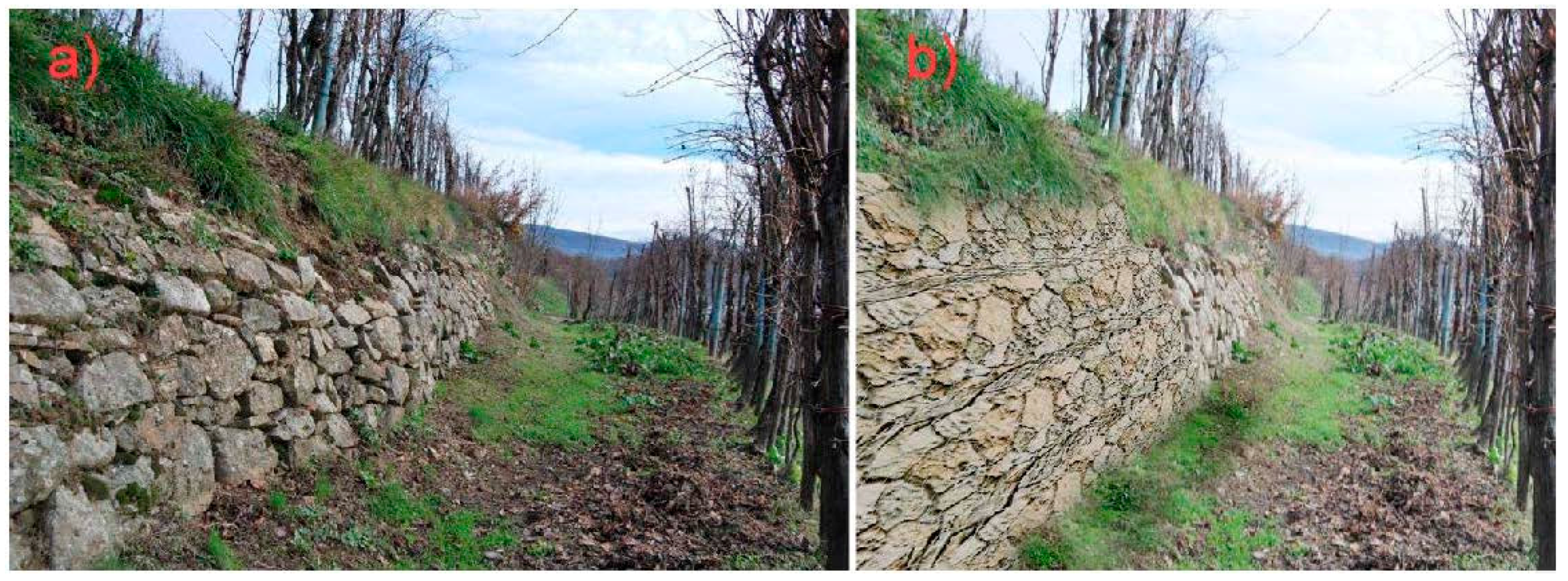
These observations may suggest alternative design evaluations based on the local technological resources and materials, seeking to interpret the changes that have taken place over time and to maintain or re-establish a mode of transformation that is a reflection of a balanced relationship between man and nature.
The feasibility, for example, of soil bio-engineering works, embankments and gabion-walls (
Figure 11), could represent alternative structural solutions, environmentally and economically sustainable, which maintain elevated standards of functionality of the terraced landscapes, even altering distinctive characters of each territory.
For these reasons, the authors consider priority the actions of ordinary maintenance (reconstruction of damaged portions of the walls, cleaning and reconstruction of the drainage systems, removal and cutting of shrub vegetation, etc.) to be conducted according to the traditional practices for an active conservation of the terraced agricultural systems. These actions need to be supported by subsidies for farmers to be applied under the Rural Development Plan (regional, inter-regional and national) or other projects.
Figure 11.
(a) Traditional dry stone wall in sample area (12); (b) Rendering of the same wall made by gabion-wall system.
Figure 11.
(a) Traditional dry stone wall in sample area (12); (b) Rendering of the same wall made by gabion-wall system.
4. Conclusions
This study has sought to illustrate a method for implementing knowledge of the terraced landscape heritage of the Tuscany Region, offering an evaluation of the typological features and the state of conservation of the subject under investigation.
Clearly, the census of the sample areas represents a non-exhaustive picture of the general situation at regional level: nevertheless, it provides an interesting approach for preliminary analyses. As regards the typological features of the individual terraced systems, particular attention has been paid to analysis of the dimensional parameters of the dry stone walls and the terraced strips. Instrumental surveys carried out on the width of the strips and the height and inclination of the walls have made it possible to compare the results with those emerging in other regions of the country, notwithstanding the considerable heterogeneity of the values obtained within the sample areas.
The authors suggest the organization of ordinary maintenance activities as a priority action, in terms both of operations designed to prevent hydrogeological instability and of intervention aimed at conserving the formal and material aspects without losing the legibility of the traces deposited over the years. Unlike in the sample areas where the ordinary maintenance was not carried out, and operations of restoration were performed using partly traditional building techniques, as in area (5), the results are not satisfactory in constructive terms. Moreover, the use of wrong materials and techniques can lead to the increase of collapses and landslides. This is due to the modest technical skills of the building firms, which reconstruct forms of terraced landscapes changed into its main elements. Furthermore, the modern reconstruction of the walls has very high costs: in local regional contexts, building costs were recorded ranging between 200 and 400 €/m3. Construction of new terraces should therefore be carefully planned and be built according to sustainable design and economic criteria.
Future challenges could concern the continuation of this analysis extended to other regional terraced contexts, to have a more detailed picture of the typological features and the state of conservation of the dry stone walls. In particular, based on the current state of conservation, a monitoring system of the terraced landscape, based on vulnerability class (damage thresholds or propensity to degradation phenomena) should be established, in order to address the decision-making process to prevent mainly situations of hydrogeological hazard and to allow better conservation of Mediterranean terraced landscapes.


