Article

Using Deep Learning Approaches to Quantify Landscape Preference of the Chinese Grand Canal: An Empirical Case Study of the Yangzhou Ancient Canal

College of Landscape Architecture, Nanjing Forestry University, Nanjing 210037, China
*
Author to whom correspondence should be addressed.
Sustainability 2024, 16(9), 3602; https://doi.org/10.3390/su16093602
Submission received: 18 March 2024 / Revised: 19 April 2024 / Accepted: 22 April 2024 / Published: 25 April 2024
(This article belongs to the Special Issue Cultural Heritage Conservation and Sustainable Development)

Abstract

:
Landscape preference emerges from the dynamic interaction between individuals and their environment and plays a pivotal role in the preservation and enhancement of the Chinese Grand Canal’s scenery. As a vast linear heritage, employing conventional methods for analyzing landscape preferences can be resource-intensive in terms of both time and labor. Amid the rapid advancement of Big Data and Artificial Intelligence (AI), a cognitive framework for understanding the Chinese Grand Canal’s landscape preferences has been developed, encompassing two primary aspects: the characteristic features of landscape preference and its spatial organization. Geotagged photographs from tourism media platforms focused on the Yangzhou Ancient Canal were utilized, and the EasyDL deep learning platform was employed to devise a model. This model assesses current landscape preferences through an analysis of photographic content, element composition patterns, and geospatial distribution, integrating social network and point density analyses. Our findings reveal that the fusion of Yangzhou Ancient Canal and classical gardens creates a sought-after ‘Canal and Watercraft Remains’ landscape. Tourists’ preferences for different landscape types are reflected in the way the elements are combined in the photographs. Overall, landscape preferences are dense in the north and sparse in the south. Differences in tourists’ perceptions of the value of and preferences for heritage sites lead to significant variations in tourist arrivals at different sites. This approach demonstrates efficiency and scalability in evaluating the Chinese Grand Canal landscape, offering valuable insights for its strategic planning and conservation efforts.

1. Introduction

Since the initiation of the process to declare the Chinese Grand Canal a World Heritage Site in 2007, the complex and dynamic connections between people and the Chinese Grand Canal landscape have primarily been addressed through planning. This top-down intervention by the government and elite groups has weakened the cultural interactions of the Chinese Grand Canal and disregarded the public’s perceptions of the landscape [1,2]. Some scenic spots along the canal have been neglected, and the authenticity of the Chinese Grand Canal landscape has not been highlighted [3,4]. As a result, tourists may find it difficult to appreciate its heritage value. This suggests that the development of the coastal space may not have fully realized the original planning vision.
Landscape preference is a crucial factor that influences the public’s behavior [5]. It is the result of the interaction between people and the perceived environment [6], and is evaluated based on the degree of preference generated by viewers in the aesthetic experience of specific landscapes [7]. This highlights the subjectivity of people in the interaction between landscapes and individuals [8]. Landscape preference expresses the aesthetic needs of tourists, and in tourism development and landscape design, fully understanding and considering tourists’ landscape preferences can locate the target market with more accuracy and design tourism products and landscape environments that better meet tourists’ needs. Simultaneously, it is possible to meet tourists’ expectations and needs by optimizing tourism services and enhancing landscape quality, thereby increasing tourists’ satisfaction and loyalty. However, the Chinese Grand Canal is a giant linear heritage site. As the world’s longest canal, it connects various geographical and cultural regions and holds rich historical and cultural significance. Its linear spatial layout and diverse cultural characteristics result in unique landscape preferences and tourist demands [9]. To analyze these preferences, traditional methods would require significant labor and time costs. How to accurately measure the landscape preference of tourists along the Chinese Grand Canal has become an urgent problem.
The rapid development of Big Data and Artificial Intelligence (AI) has led to the application of Internet Big Data technology, providing an efficient way to revisit the public understanding of the cultural heritage of the Chinese Grand Canal [10]. A cognitive framework has been developed to understand the landscape preferences of the Chinese Grand Canal. The framework consists of two main aspects: characteristics of landscape preferences and spatial organization. Using multi-source Big Data and deep learning algorithms, we converted public preferences into research data. This data was then combined with a deep learning model to create an efficient method for measuring landscape preferences along the Chinese Grand Canal. The research goal was to provide a tool for acquiring, analyzing, and understanding the public’s intentions for choosing sustainable spatial practices along the Chinese Grand Canal. The deep learning algorithm compensates for the limitations of previous image processing methods, such as small sample sizes and low processing efficiency. It leverages the value of massive data to ensure data integrity and objectivity [11]. In this experiment, geotagged photos from a Chinese tourism media platform were used as the data source. The EasyDL development platform in Baidu Intelligent Cloud was utilized to construct a deep learning model for image content recognition. The combination of social network analysis and GIS spatial analysis can aid in comprehending the shared cognitive preferences of tourists for ancient canal landscapes. It also reveals the spatial distribution patterns and correlations of different landscape types. The results of this experiment are expected to provide guidance for planning and protecting spatial landscapes along the Chinese Grand Canal. Additionally, it will aid in the scientific planning of the layout and functional zoning of coastal spaces, as well as the protection and preservation of the historical and cultural value of the Chinese Grand Canal. Furthermore, it may promote the development of local tourism.

2. Literature Background

Linear cultural heritage is a new type of world cultural heritage protection in the 21st century. Practical research on linear cultural heritage has brought new concepts to cultural heritage protection from dynamic, holistic, and territorial perspectives [12,13]. China’s linear cultural heritage has a long historical lineage, covers a large spatial area, and contains multiple types of tangible and intangible cultural heritage. The definition of a heritage canal is relatively broad, as it can be regarded as a monument, a defining feature of a linear cultural landscape, or a component of a complex cultural landscape [14,15]. As China’s largest linear cultural heritage site, current research on the Chinese Grand Canal landscape focuses on two directions: landscape planning (and conservation), and historical development. The former clarifies the development path of the Chinese Grand Canal landscape from the perspective of planning, coordinates the control and inheritance of the canal landscape, and explores the new direction and content of the orderly inheritance and sustainable enhancement of the canal heritage landscape [16,17,18]. The latter uses ancient books and maps to deeply explore the characteristics and development of the spatial form of the Chinese Grand Canal under the influence of economic society and culture and analyzes the landscape characteristics of the Chinese Grand Canal from the perspective of hydraulic facilities, functional layout, spatial elements, and composition patterns [19,20,21]. In general, the Chinese Grand Canal landscape research has not broken the paradigm, with top-down expert perspectives studying the static protection planning and characteristics, and less attention being given to the user’s perspective of the Chinese Grand Canal landscape evaluation research. For the traditional landscape evaluation research of the Chinese Grand Canal, it is mostly investigated from a quantitative perspective to construct a comprehensive evaluation index system from different dimensions and select evaluation indexes and determine evaluation standards through data collection and field research [22,23]. A small number of studies use both qualitative and quantitative perspectives. The first qualitative evaluation digs deep into the cultural connotation and historical value of the Chinese Grand Canal landscape to determine the landscape characteristics of the Chinese Grand Canal section in the region, and then provides objective and accurate data support for the Chinese Grand Canal landscape through quantitative evaluation [24,25,26]. In recent years, some researchers have paid attention to the terms of ‘multi-target’ and ‘multi-stakeholders’ research in the study of Chinese Grand Canal heritage and included the perspective of tourists in the research system. The focus is gradually shifting from ‘things’ to ‘people’, emphasizing the key role of users in preserving the original qualities of the Chinese Grand Canal landscape [27,28]. As a result, tourists, as an ideal evaluation subject, have attracted the attention of researchers, and it has become a trend to study the evaluation of the Chinese Grand Canal landscape from their perspective.
The evaluation method for landscape preference has evolved with the rapid development of Big Data on the internet. Previously, tourists used photographic questionnaires to provide subjective evaluations. However, now social media user-generated content (UGC) picture metadata is used to obtain perception and preference data [29,30,31]. Tourism media platforms provide UGC, making the evaluation subject a real practitioner of landscape interaction. Currently, the main platforms for tourists in China to upload content such as reviews and photos, as well as contribute to landscape preference research, are websites such as ‘Mafengwo Tourism’, ‘Trip.com Group’, and ‘Qunar’ [32,33,34,35]. These websites provide a significant amount of sample data. In addition to the picture content, the attribute information and shooting data behind the pictures such as latitude, longitude, time, exposure time, focal length, flash mode, and white balance, can be quantitatively analyzed as data for users’ landscape preferences [36,37]. Previous studies on landscape preferences have mainly used Grounded Theory with manual coding to identify defined image content [38,39]. However, the image processing method that relies on manual interpretation is more subjective and susceptible to the cognitive influence of the researcher, leading to bias. Additionally, it requires more manpower and material resources, making it unsuitable for evaluating large-scale landscapes. In recent years, the rapid development of Artificial Intelligence has provided a new direction for solving large-scale regional research. Deep learning algorithms are used in the field of computer vision to build a neural network that simulates the human brain for analysis and learning [40,41,42]. This achieves image classification, target detection, and image segmentation, replacing the heavy work of manual identification. Computer vision applications are rapidly advancing due to large image datasets and cloud computing. Various platforms such as Google Cloud Vision, Microsoft Azure, Clarifai, and Baidu Intelligent Cloud (among others) [43,44,45] have been developed. Baidu Intelligent Cloud’s EasyDL development platform, which is based on deep learning algorithms, can customize labels to train AI models for professional landscape scene recognition.

3. Materials and Methods

3.1. Study Area and Data Sources

3.1.1. Study Area

The Chinese Grand Canal spans 27 cities in 8 provinces and municipalities, including 27 sections and 58 heritage sites. It passes through 35 cities from south to north, but Yangzhou is the only city that has grown up with it. The city of Yangzhou, located in Jiangsu Province, boasts the earliest excavation, the most stable navigation channel, and the best-preserved cultural relics along the river section of the Chinese Grand Canal [46]. As a leading city in the declaration of the Chinese Grand Canal as a World Heritage Site, the Yangzhou Ancient Canal section was chosen as the subject of empirical research. The Yangzhou Ancient Canal is a 20 km-long waterway that flows southwest from Wantou, passes through the Golden Dam, and enters the urban section of Yangzhou to the south until the Gaomin Temple. This section features a heritage channel of the Yangzhou Ancient Canal and six heritage sites. The heritage sites include the Slender West Lake, the Tianning Temple Rowan Palace (which includes the Chongning Temple), the Ge Garden, Wanglumen Salt Merchant Residence, Lu Shaoxu Salt Merchant Residence, and Yanzong Temple (Figure 1).

3.1.2. Data Acquisition and Pre-Processing

Geotagged photos are photos with geographic locations added at the time of capture or in post-processing, providing not only visual image information but also geographic attributes that can be used to analyze the image content and spatial distribution characteristics of the photo. The travel media platforms Mafengwo Tourism, Six Feet, and 2BULU support users to post geotagged photos, which provide a platform for travel enthusiasts to show their travel footprints and share their experiences and preferences. Therefore, in this study, the geotagged photos posted by these three platforms became our main data source. A Python crawler program was used to collect photo URLs, travelogue titles, user IDs, photo IDs, and the latitude and longitude of the shooting location, among other information, using ‘Yangzhou Ancient Canal’ as the search keyword. To crawl user-defined location label information, data obtained from Mafengwo Tourism needs to be added. It is important to note that Six Feet and 2BULU require location to be turned on when users record photos, resulting in complete geographic information of photos from these two platforms. However, the photos in Mafengwo Tourism may lack geographic information due to the variety of shooting equipment used by users. Some photos were taken with DSLR cameras or cell phones without turning on positioning. To address this issue, photos without geographic information were screened and user-defined labels were converted to geographic coordinates using LocaSpaceViewer-4.2.2 and added to the photo’s EXIF information. This process was undertaken to increase the amount of data in the study sample. A total of 13,820 photos were collected as of 3 February 2023. After screening out non-landscape content images and images whose geographic locations do not belong to the Yangzhou Ancient Canal area, 7600 geotagged photos were selected as the database for this study.

3.2. Research Design

A cognitive framework of Chinese Grand Canal landscape preference was constructed (Figure 2) consisting of two parts: landscape preference characteristics and landscape preference spatial structure. The framework was used to analyze Chinese Grand Canal landscape preference. The experimental data was obtained from geotagged photos on tourism media platforms using a Python crawler program (Octopus Collector-8.6.7). The raw data was pre-processed by cleaning, filtering, and refining image attribute information. When analyzing the characteristics of landscape preference, the image content of geotagged photos is used to determine public preferences for the landscape elements, types, and combinations of different landscape types in Yangzhou Ancient Canal. Customized landscape element multi-labels and landscape type single labels are obtained using API combined with manual refinement. Experimental data was randomly sampled to create a training set. The resulting labels were added to each photo. Object detection models and image classification models were built, trained, and evaluated to recognize the landscape elements in the photos and the landscape types to which the photos belong. Co-occurrence networks with multiple labels for elements in different landscape types are constructed. Social network metrics are used to calculate and summarize element combination patterns. The spatial structure of the landscape preferences is analyzed by transforming the geographic information contained in the pictures into spatial point elements. The degree of aggregation is observed with the help of a GIS platform.

3.3. Data Processing

3.3.1. Image Content Analysis Based on Deep Learning Models

EasyDL is a deep learning platform launched by Baidu Intelligent Cloud. It includes EasyDL Image, which is used to customize deep learning models for image analysis, such as image content comprehension, classification, and object detection. This platform offers quantitative position analysis and more. To analyze the landscape preferences of the Chinese Grand Canal, it is necessary to identify the type of landscape depicted and the elements it contains. This requires training two models for object detection and image classification. The object detection model detects multiple subjects, their positions, and quantities in a diagram, while the image classification model recognizes whether a diagram represents a certain type of state or scene.
To prepare for labelling and training the model, it is essential to establish the custom label set.
Object Detection-Multi Labeling: Baidu Intelligent Cloud’s general object and scene recognition API was used to predict labels for a randomly selected training set from the research sample. Labels with confidence scores between 0 and 1 were returned for each image in the training set. Only labels with confidence scores greater than 0.5 were selected as the initial acquisition of the image content for the training set. The labels for the landscape elements of the Chinese Grand Canal were refined based on objective perception by the researcher.
Image Classification—Single Label: Table 1 summarizes the heritage classification of the Yangzhou Ancient Canal based on the heritage composition of the Chinese Grand Canal World Heritage Site [47] in combination with the ‘Administrative Measures for the Protection of the Heritage of the Chinese Grand Canal’ and the ‘Requirements for the First Stage of Preparation of the Chinese Grand Canal Heritage Protection Plan’ [48]. Finally, the material and non-material landscape characteristics of the heritage site were used to propose five landscape types for Yangzhou Ancient Canal: ‘Canal and Watercraft Remains’, ‘Classical Garden’, ‘Architecture and Settlement’, ‘Natural Landscape’, and ‘Culture and Life’.
The training set is labeled manually using multiple labels for landscape elements and single labels for landscape types through the EasyDL development platform. When the number of images in each label exceeds 40, semi-supervised learning, incremental training, error correction, and iterative training models are employed to obtain object detection and image classification models with high accuracy, efficiency, and generalization ability.

3.3.2. Social Network Analysis of Labels

Social network analysis considers ‘relationship’ as the fundamental unit of analysis and employs graph theoretic tools and algebraic modeling techniques to describe relationship patterns and investigate their impact on the structure’s members or the whole structure [49,50,51]. The element co-occurrence matrix of five Chinese Grand Canal landscape types can be constructed based on the model’s prediction of multiple labels of landscape elements in each picture with a confidence level greater than 0.5. The relationship network was visualized using Gephi-0.9.4. Each node represents an element label, while edges connect nodes and represent the co-occurrence relationship between two connected labels in a picture. This analysis helps to identify combination characteristics between element labels. The matrix is imported into UCINET-6 for calculating social network indexes. The network density, clustering coefficient, and centrality are selected to characterize the network structure. Network density is calculated as the ratio of the total number of actually existing relationships to the total number of theoretically possible relationships in the network, which reflects the sparseness of the network nodes [52,53]. The average clustering coefficient is an indicator of the local network structure, reflecting the group nature of neighboring nodes. In this study, Degree centrality is used to represent the size of labels and the correlation between labels, as it portrays the dependence of other nodes on a node [54,55].

3.3.3. Point Density Analysis of Geotagged Photos

The GIS Point Density Analysis tool calculates the density of point elements surrounding each output raster image element. A neighborhood (circle or rectangle) is defined around the center of each raster image element, and the density of point elements is obtained by adding the number of points in the neighborhood and dividing it by the neighborhood area [56,57]. This analysis helps to understand the data aggregation in the region. Geotagged photos are input into GIS to generate point elements. These points are then analyzed for point density to determine the spatial structure. The deep learning model provides image classification data, which is used to classify the point elements and obtain the spatial structure for different landscape types.

4. Results

4.1. Yangzhou Ancient Canal Landscape Elements

4.1.1. Baidu Universal Object and Scene Recognition API Results and Label Extraction

Based on related literature studies [34,43], it is recommended that the training set should consist of approximately 5% of the sample size. Therefore, a total of 500 photos were randomly selected from the cleaned and screened geotagged photo dataset to serve as the training set, accounting for 6.6% of the overall sample. The model labeling, training, and evaluation were conducted accordingly. To improve the reliability and comprehensiveness of landscape element labeling, Baidu Intelligent Cloud’s pre-trained generic object and scene recognition API interface was utilized to predict the training set photos prior to manual labeling. Each photo was assigned 5 labels with confidence scores, and a total of 318 labels with confidence scores exceeding 0.5 were filtered out. The histogram in Figure 3 passively displays the top 20 high-frequency labels obtained through collation, thereby identifying the constituent elements of the photos.
The results indicate a large number of API prediction result labels and reveal three issues. Firstly, there are duplicated meanings among some labels, such as ‘Street’ and ‘City Street’. Secondly, many labels are not related to landscape characteristics, such as ‘Car’ and ‘Screenshot’. Thirdly, the label names are not strongly related to the Yangzhou Ancient Canal, such as ‘Lake’ and ‘River’. These problems have caused biased results and difficulties in data processing. The frequency statistics of each label cannot accurately reflect the number of landscape elements in the photos, and the co-occurrence network construction cannot precisely express the connection between landscape elements. API recognition results can provide a large amount of initial data, but their accuracy, completeness, and relevance are limited. This is because API is trained based on algorithms and a large amount of data, and their recognition ability is affected by a variety of factors such as training data and algorithm design. Manual refinement, on the other hand, is able to extract key information in a targeted manner according to specific needs, making up for the shortcomings of API recognition. Landscape elements often have complexity and diversity, and many subtleties are difficult for API to accurately recognize. Therefore, through the judgment and identification of experts, more accurate and richer landscape element information can be extracted. Finally, based on the API recognition results and manual refinement of landscape elements, 36 labels were collated and designated as the multiple labels for the object detection model (Table 2).
‘Landscape Facility’ is differentiated from Classical Garden elements such as ‘Ancient Pavilion’ and ‘Rockery’ and mainly refers to modern landscape service facilities, such as seating and structures. The label ‘Tree’ refers to a single, clearly visible tree, while ‘Grouping Trees’ refers to a connected group of trees. ‘Lighting’ refers to a point source of light that sets the mood at night. The label ‘Residence’ reflects the traditional residential architecture in the Yangzhou Ancient Canal area, which blends ancient and modern elements. The distinction between ‘Store’ and ‘Modern Architecture’ is primarily based on the shape of the buildings, with ‘Modern Architecture’ typically featuring clusters of modern buildings.

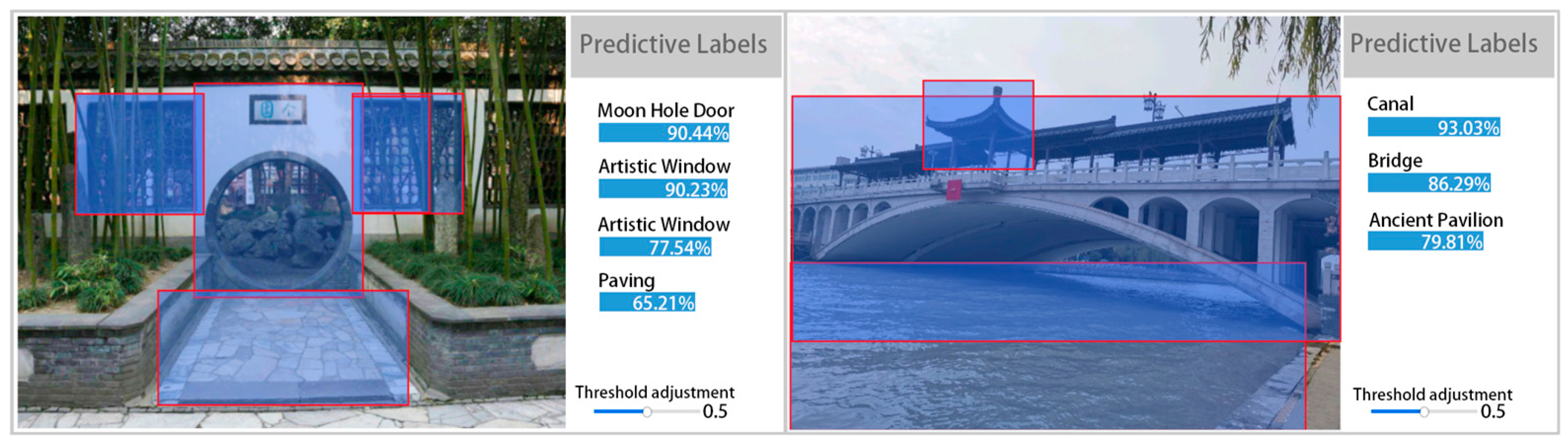
4.1.2. Analysis of Object Detection Model Results

After multiple rounds of correcting the prediction results and iterative training, the object detection model performs optimally at a confidence level of 0.5. It has a precision rate of 92.3%, a recall rate of 88.5%, and a mAP of 95.7%. These results indicate that the model is excellent and can accurately predict the landscape elements of the Yangzhou Ancient Canal (Figure 4). The mAP values for different labels are shown in Figure 4, and all labels have a mAP greater than 70%. The precision and recall of each label were satisfactory. Batch prediction of all 7600 geotagged photos with the trained object detection model yields landscape element labels with a confidence threshold greater than 0.5 for each image (Figure 5).
By organizing and counting the frequency of words and the proportion of each label in Table 3, we can obtain the results of the overall preference for landscape elements of the Yangzhou Ancient Canal. Generally, tourists perceive ‘Tree’, ‘Grouping Trees’, and other individual or grouped plants as the elements with the highest frequency. Based on the characteristics of the photographs, plants often appear as the background in the photographs of the ancient canal preferred by tourists. The frequency of the labels ‘Canal’ and ‘Revetment’ confirms that the heritage channel is the main perception of Yangzhou Ancient Canal’s cultural heritage. The public recognizes the way of protecting and utilizing its landscape, which attracts tourists to take photos to commemorate their visit. Labels such as ‘Lighting’, ‘Night Sky’, and ‘Boat’ show tourism’s preference for the night view of the ancient canal. The tourism sector has been focusing on creating, publicizing, and improving facilities for boat cruises. As a result, night cruises have become a popular way to view the landscape along the Chinese Grand Canal. Tourists choose to record the Chinese Grand Canal landscape at night. The Classical Gardens (mansion gardens) and residences formed in the canal’s salt merchant culture are a prominent subsidiary heritage of the Yangzhou Ancient Canal. There are many labels related to the landscape, such as ‘Ancient Architecture’, ‘Traditional Houses’, and ‘Rockery’. The Classical Gardens and houses form a landscape of great ornamental value, reflecting the local culture’s attractiveness. The area’s culture enhances the landscape appeal.

4.2. Yangzhou Ancient Canal Landscape Elements

The image classification model has a precision rate of 97.5%, a recall rate of 97.6%, and an F1-score of 97.5% for the harmonic mean of precision and recall. The model is suitable for photo classification. Image classification model—single labels characterize the landscape type of each photo. Five landscape types were extracted based on Table 1: ‘Canal and Watercraft Remains’, ‘Classical Garden’, ‘Architecture and Settlement’, ‘Natural Landscape’, and ‘Culture and Life’. Table 4 shows the number of photos of different landscape types, with ‘Canal and Watercraft Remains’ (26.7%) being the most preferred ancient canal landscape type by the public, which should have a strong correlation with the river as the main body of the heritage. ‘Culture and Life’ accounts for only 11.8% of the photographs, as it contains intangible elements that are difficult to express through photography. The other three landscape types account for approximately 20% of the photographs, with little difference in preference.

4.3. Patterns of Combining Elements of Different Landscape Types

4.3.1. Network Characteristics

After the photos have been categorized into five landscape types, the distribution and connection of photo landscape elements across different landscape types can be analyzed to explore the patterns of element combinations in tourists’ landscape preferences. By examining the co-occurrence relationship of labels within each photo, a co-occurrence matrix of element labels contained within each landscape type can be generated. The UCINET6was used to calculate the structural characteristics of each co-occurrence network based on the five co-occurrence matrices (Table 5). The ‘Natural Landscape’ network has a small number of nodes and edges but a high density, indicating close connections between the labels of this landscape type and a relatively uniform composition of elements in the photographs. The four remaining types of network density are low, indicating a relatively decentralized network structure. The elements are not closely linked to each other, which reflects the fact that each photo has a variety of combination patterns of elements, or the photos mainly show individual landscape elements. The average clustering coefficient of the ‘Canal and Watercraft Remains’, ‘Classical Garden’, and ‘Natural Landscape’ landscape types is higher, and the average shortest path length is shorter. This suggests that the network connections within the clusters are more complete and the network exhibits a ‘small world’ characteristic.

4.3.2. Combination of Elements of Landscape Types

Importing the co-occurrence matrix into Gephi allows the generation of co-occurrence network graphs. This study focuses on the frequency of co-occurrence between tags and does not discuss the ability of nodes to be controlled or uncontrolled. Therefore, the graph is weighted by the degree of the node to determine the size of each node, which reflects the degree of the center of each node (i.e., the frequency of co-occurrence between labels) (Table 6).
In the landscape type ‘Canal and Watercraft Remains’, ‘Grouping Trees’, ‘Canal’, ‘Tree’ and ‘Ancient Architecture’ have a relatively high degree of centrality. This is the basic content of most of the photos. Most of the photos are taken from the riverbank, with the river as the main body, trees or modern buildings as the background, and ancient buildings, boats, and bridges as the scenes. At the same time, the integration of landscaping, night sky, and lights reinforce the image of the canal as an intertwining of ancient and modern cultures. In the ‘Classical Garden’ landscape type, typical images of a classical garden such as ‘Rockery’, ‘Artistic Window’, ‘Moon Hole Door’, and ‘Ancient Pavilion’ are the main components of the photo. In addition, the ‘Canal’ has a high degree of centrality in this type of landscape. The reason is that the Slender West Lake is a tributary of the Yangzhou Ancient Canal, and several canals are connected to the Yangzhou Ancient Canal, forming a unique landscape of the fusion of canals and gardens in the Yangzhou Ancient Canal. In the landscape type of ‘Architecture and Settlement’, ‘Store’, ‘Ancient Architecture’, ‘Residence’, and ‘Alley’ are the most common. ‘Alley’ and other scenes of settlements along the Yangzhou Ancient Canal attract tourists. The ‘Lighting’ label is the most numerous, but the degree of centrality is not high, so it appears a lot in a small number of night photos, creating the atmosphere of a prosperous night scene in the heritage of the canal surrounding settlements, such as Dongguan Street. The elements of ‘Natural Landscape’ are relatively simple, mainly focusing on plants, canal water and plant details, showing the natural landscape on both sides of the canal. The ‘Culture and Life’ landscape type accounts for a relatively small proportion, the intangible form of traditional canal culture and life of the public, the photographs capture the objects affected by culture and life through macro photography, with handicrafts and food as the main content of expression. The connection between the elements is not close.

4.4. Spatial Structure of Landscape Preferences in the Yangzhou Ancient Canal

Photo density can be used to reveal the public’s spatial preferences for landscapes (i.e., high-density photos reflect high visitation rates and preferences) [39]. Overall (Figure 6a), photos are mostly concentrated in the northern half, with only Canal Sanwan Park in the south being relatively concentrated. The northern half of the Dongguan Historical and Cultural Tourism Area is the most densely photographed area, and this area includes many popular tourist attractions such as Dongguan Street and Ge Garden, making it the most frequently visited location by the public for photos and maps. The Slender West Lake Scenic Area follows with a higher concentration of photos, while photos along the banks of the Yangzhou Ancient Canal show an even distribution along the canal.
The ‘Canal and Watercraft Remains’ landscape type (Figure 6b) has the highest concentration of photos in the Slender West Lake Scenic Area. The Shashi River area, a tributary of the Yangzhou Ancient Canal, is the next highest area, and the rest of the photos are evenly distributed along the Nanmen Ruins Pier to Guanchao Road. The Slender West Lake Scenic Area, Ge Garden, and He Garden in the ‘Classical Garden’ landscape type (Figure 6c) are the representatives of Yangzhou’s classical gardens, with obvious landscape characteristics and relatively concentrated geographical distribution, so the preferences are also mostly distributed in these three areas. The spatial distribution of ‘Architecture and Settlement’ and ‘Culture and Life’ (Figure 6d,f) is similar, and both are relatively concentrated around the Dongguan Historical and Cultural Tourism District. Dongguan Street is a representative historical and cultural street in Yangzhou City, where cultural prosperity and people’s settlement contribute to the landscape characteristics of ‘Architecture and Settlement’, resulting in the spatial structure of the public’s preference for the two landscape types is similar. The Slender West Lake Scenic Area, Dongguan Historical and Cultural Tourism District, and Sanwan Wetland Park are the most preferred areas for the ‘Natural Landscape’ landscape type (Figure 6e). In addition to the scenic landscape along the Slender West Lake, the natural landscape with its modern planning and design can still attract tourists. The Sanwan Wetland Park in the southern part of the Yangzhou Ancient Canal is based on the Sanwan of the canal and the surrounding wetlands, and its natural landscape is recognized by most tourists.
In summary, the natural distribution characteristics of the landscape and the aesthetic choices of the public together determine the spatial distribution characteristics of preferences. The Dongguan Historical and Cultural Tourism District, including the Ge Garden and its surrounding landscape environment, is an area where multiple landscape types are most comprehensively developed. Analyzing the geographical locations of the heritage sites along the Yangzhou Ancient Canal shows that there are big differences in the preferences of the heritage sites. Slender West Lake and Ge Garden are the most preferred among the heritage sites and contain multiple landscape types, and the remaining four heritage sites are less visited by tourists.

5. Discussion

Most of the previous studies on the Chinese Grand Canal landscape focused on qualitative analysis, mainly exploring the landscape composition, characteristics, planning, and protection methods of the landscape as an important cultural heritage location. For example, Hanzhi Lin constructs a canal heritage corridor resource evaluation system for the Yangzhou section of the Beijing-Hangzhou Chinese Grand Canal based on the hierarchical analysis method to evaluate the canal landscape resources of the Yangzhou section of the Chinese Grand Canal [48]. Xibo Chen proposes that the ecological construction of the Beijing Chinese Grand Canal Cultural Park should be based on the principles of ecological and cultural diversity and harmonious symbiosis, and puts forward the ecological construction path in view of the ecological construction characteristics of the Beijing Chinese Grand Canal National Cultural Park [58]. Lin Tian explores the function and type of Chinese Grand Canal waterfront landscape design, and innovates the methods and strategies of the Chinese Grand Canal Park waterfront landscape design [59]. These research perspectives provide us with rich theoretical background and planning suggestions, and offer a scientific and reasonable planning path for the top-down construction of the Chinese Grand Canal coastal space. However, the current research pays less attention to the landscape preferences from the perspective of tourists. In other words, we understand the objective value of the Chinese Grand Canal heritage at the planning level, but fail to fully grasp the subjective feelings and perceptions of tourists toward this heritage. In fact, this objectivist research orientation ignores the subjective position of people in heritage conservation. The heritage of the Chinese Grand Canal is not only bricks and mortar, but also the memory of history and cultural heritage. If there is a lack of human subject participation and cognition, then the value of the heritage can hardly be truly reflected. Therefore, from the perspective of tourists, exploring their preferences for Chinese Grand Canal landscapes not only helps us to recognize the Chinese Grand Canal heritage more comprehensively, but also provides a more precise direction for the protection and inheritance of the heritage. This study can provide a more comprehensive and in-depth understanding of the landscape preference characteristics and spatial structure along the Chinese Grand Canal from the perspective of Chinese Grand Canal landscape preference. By analyzing a large number of geotagged photographs, we can find out the degree of tourists’ preference for different landscape elements, as well as the spatial distribution pattern and correlation of these elements. This will provide scientific and effective guidance for the planning and protection of the space along the Chinese Grand Canal, which will help to optimize the spatial layout and enhance the tourist experience.
Previous methods of measuring tourist preferences include the Tourist Employed Filming Method and the Photographic Questionnaire Method. Both methods involve in-depth analysis of respondents’ photographic behaviors and choices, and the research process requires a large number of volunteers and may also require certain requirements for photographic equipment. However, both are limited by sample size. In addition, the image processing tools of these methods often rely on manual interpretation, which not only increases the cost of the research but also affects the objectivity of the results. Along with that, these methods are difficult to cover such a large linear space as the Chinese Grand Canal, which limits our research horizon. To overcome these limitations, this study adopts a new approach: the use of geotagged photos from travel social media. These photos are not only large in number and easily accessible, but also can truly reflect the trajectory and visual focus of tourists. By using deep learning image content recognition techniques, we are able to automatically extract key information from the photos and mine the elements that may be missed by subjective recognition of traditional image content. This method has significant advantages over traditional methods. First, it can process a large amount of sample data efficiently and inexpensively, making our study more representative. Second, the results are more objective and accurate due to the objective image recognition technique. Third, this method can cover the entire linear space of the Chinese Grand Canal in the region, which greatly expands our research horizon.
However, the study still has the following two points that deserve further exploration: first, the refinement of customized element labels. The study adopts Baidu’s generic object and scene API combined with manual identification of Chinese Grand Canal landscape element labels, and the labels, such as plants and buildings, are relatively broad. The labels can be refined so that the model can accurately recognize the details of plant species and building shapes in the image and mine more Chinese Grand Canal landscape preference characteristics. Second, time information is included in the study. By analyzing the temporal evolution of preferences from the time dimension, the static preference characteristics can be transformed into dynamic preference trends, not only to grasp the key contents of the construction, but also to predict the current and future popular trends.

6. Conclusions

A cognitive framework of Chinese Grand Canal landscape preference was constructed from two parts (landscape preference characteristics and spatial structure), and a deep learning-based method was designed to measure Chinese Grand Canal landscape preference. The photo elements and types are recognized by labeling and training the image deep learning model, and the results obtained are used to study the combination patterns of elements of different landscape types by social network analysis, and to analyze the spatial structure of preferences by combining with the geographic information of the photos. The experimental results show that the measurement method can efficiently extract the preference characteristics of the Chinese Grand Canal landscapes in the region and analyze the preference composition in terms of elemental and spatial dimensions, which solves the difficulty of researching the preference characteristics of large-scale landscapes, especially linear heritage. Taking the Yangzhou Ancient Canal as a case study, the following conclusions are obtained: the fusion of Yangzhou Ancient Canal and classical garden elements creates a unique ‘Canal and Watercraft Remains’ landscape that is highly sought after by tourists. Tourists especially enjoy taking boat rides at night to experience the modern and classical culture along the Grand Canal. In the co-occurrence network, the elements with high centrality represent the typical images of each landscape type and reflect tourists’ preferences for different landscape types. These elements are closely related to each other, representing the phenomenon of ‘small worlds’, and together construct the combination of characteristic photo elements of each landscape type. Among them, the ‘Culture and Life’ landscape type accounts for a relatively small proportion of photographs, and its spatial distribution is similar to that of the ‘Architecture and Settlement’ landscape type, which is mostly concentrated in the area of the Dongguan Street Historical Neighborhood. Overall, the spatial structure of landscape preferences is characterized by a dense northern part and a sparse southern part. However, there are significant differences in tourists’ preferences between heritage sites. Except for Ge Garden and Slender West Lake, the other four heritage sites are relatively neglected by tourists, which reflects the differences in tourists’ perceptions of and interest in the value of different heritage sites.
Based on the experimental conclusions of the landscape preference of Yangzhou Ancient Canal, it can provide guiding suggestions for the planning and design along the canal. (1) Enhance the excavation of the cultural value of the landscape of the heritage sites. There is a big difference in the preferences of tourists to the heritage sites, with the Slender West Lake and Ge Garden taking up a large share of the tourist pressure, while the other Chinese Grand Canal heritage sites of Wang, Lu Residence, and Yanzong Temple are unoccupied. From the perspective of objective conditions, these four heritage sites have sufficient historical and cultural value, but tourists do not pay attention to them. This requires designers to give full play to the role of landscape as a material carrier of culture in landscape planning, and build a perception bridge between tourists and landscape, so that tourists can better understand the value of cultural heritage. (2) Improve the level of natural landscape construction. As the cultural relics are all located in the northwest region of the Ancient Canal, tourists pay less attention to the southern part of the Yangzhou Ancient Canal. However, from the point of view of the spatial structure of natural landscape type preference, the natural landscape around the Slender West Lake and the beautiful natural landscape of the canal demonstrated by the Sanwan Wetland Park are attractive to tourists. This provides new ideas for landscape planning and design for the continuous development of Yangzhou Ancient Canal. (3) Emphasize the importance of the heritage of the settlements along the canal. The high spatial overlap between the landscape types of ‘Architecture and Settlement’ and ‘Culture and Life’ demonstrates the importance of the heritage of coastal settlements. The material carriers of the settlements are rich in humanistic connotations, which can stimulate the interest of tourists. At the same time, the survival of the indigenous people in the settlements reflects the dynamic reconstruction between the indigenous subjects and the canal, as well as the sustainability of the combination of culture and reality.

Author Contributions

Conceptualization, Y.L. and B.Q.; methodology, Y.L.; software, Y.L.; validation, Y.L. and B.Q.; formal analysis, Y.L.; investigation, Y.L.; resources, Y.L.; data curation, Y.L.; writing—original draft preparation, Y.L.; writing—review and editing, B.Q.; visualization, Y.L.; supervision, B.Q.; project administration, Y.L. and B.Q.; funding acquisition, B.Q. All authors have read and agreed to the published version of the manuscript.

Funding

This research was funded by the Ministry of Education Planning Foundation on Humanities and Social Sciences, Project No. 19YJAZH072; Qing Lan Project, Young academic leaders (2021); National Natural Science Foundation of China (NSFC) General Project (31971721).

Institutional Review Board Statement

Not applicable.

Informed Consent Statement

Not applicable.

Data Availability Statement

The data that support the findings of this study are available upon reasonable request from the authors.

Conflicts of Interest

The authors declare no conflicts of interest.

References

  1. Zhang, F.; Qiu, B. The Attributes of the Chinese Grand Canal’s Tangible Cultural Heritage Recognition and Practical Reflection. Acad. Bimest. 2021, 5, 146–151. [Google Scholar] [CrossRef]
  2. Qiu, B.; Zhang, F. Collective Memory and the Understanding and Description of the Chinese Grand Canal’s Original Landscape. Southeast Cult. 2021, 280, 23–28. [Google Scholar]
  3. Lu, L.; Wang, S. The Study on Cultural Heritage of the Chinese Grand Canal: The Achievements, the Lack and the Advisements. Agric. Hist. China 2019, 38, 137–145. [Google Scholar]
  4. Wang, X. The Preservation of the Chinese Grand Canal (Hangzhou Section) in the Post-UNESCO World-Heritage-Bid Period: ‘Integrity’ as a Focus. Southeast Cult. 2016, 254, 20–26. [Google Scholar]
  5. Kaplan, R. The Analysis of Perception via Preference: A Strategy for Studying How the Environment Is Experienced. Landsc. Plan. 1985, 12, 161–176. [Google Scholar] [CrossRef]
  6. Kaplan, R.; Kaplan, S.; Brown, T. Environmental Preference: A Comparison of Four Domains of Predictors. Environ. Behav. 1989, 21, 509–530. [Google Scholar] [CrossRef]
  7. Zube, E.H.; Sell, J.L.; Taylor, J.G. Landscape Perception: Research, Application and Theory. Landsc. Plan. 1982, 9, 1–33. [Google Scholar] [CrossRef]
  8. Wu, J.; Xu, Y.; Ren, J.; Zhang, W.; Li, M.; Pu, H. Progress and Geographical Response on Landscape Preference. Sci. Geogr. Sin. 2021, 41, 656–663. [Google Scholar] [CrossRef]
  9. Zhang, G.; Fu, B.; Zhao, X.; Tao, S. An Exploration on Linear Cultural Heritage Protection and Inheritance Path of the Grand Canal. City Plan. Rev. 2022, 46, 27–35. [Google Scholar]
  10. Tieskens, K.F.; Van Zanten, B.T.; Schulp, C.J.E.; Verburg, P.H. Aesthetic Appreciation of the Cultural Landscape through social media: An Analysis of Revealed Preference in the Dutch River Landscape. Landsc. Urban Plan. 2018, 177, 128–137. [Google Scholar] [CrossRef]
  11. Chesnokova, O.; Purves, R.S. From Image Descriptions to Perceived Sounds and Sources in Landscape: Analyzing Aural Experience through Text. Appl. Geogr. 2018, 93, 103–111. [Google Scholar] [CrossRef]
  12. Wen, X.; Xu, H.; Wu, D. Research on Bilingual Ontology Construction of Linear Cultural Heritage: A Case Study of Jiaxing Canal Culture. Libr. Inf. Serv. 2023, 67, 107–120. [Google Scholar] [CrossRef]
  13. Xu, F.; Wang, Z.; Zhang, H. Application of Short Video in Digital Communication of Grand Canal’s Linear Cultural Heritage. Arch. Constr. 2022, 9, 51–54. [Google Scholar]
  14. Wu, J.; Li, H.; Deng, T.; Luo, S.; Hu, J.; Zhang, Z.; Niu, C.; Wang, K.; Jiang, Y.; Su, S. Comprehensive Land Consolidation and Linear Cultural Heritage Protection, Utilization, Cohesion and Integration: A Case Study of the Gutian Section of the Meiguan Historical Trail, South China Historical Trail, Guangdong Province. Trop. Geogr. 2024, 44, 379–392. [Google Scholar]
  15. Sun, B.; Guo, F.; Li, R.; Chen, X. Linear cultural heritage landscape visual perception location model and demonstration. Prog. Geogr. 2024, 43, 80–92. [Google Scholar] [CrossRef]
  16. Xu, Y.; Yang, Y. Hangzhou’s exploration on the enhancement of the Chinese Grand Canal landscape in the post-heritage era: A case study of the Hangzhou Section of the Beijing-Hangzhou Canal. Beijing Plan. Rev. 2020, 194, 36–40. [Google Scholar]
  17. Wang, J.; Han, B.; Liu, H.; Xi, R. Research on the landscape modeling of Beijing Chinese Grand Canal cultural belt. Chin. Landsc. Archit. 2021, 37 (Suppl. S1), 172–177. [Google Scholar] [CrossRef]
  18. Wang, H.; Wang, C.; Zhang, C. Study on seasonal appearance of plant landscape in Tongzhou Canal Forest Park. Chin. Landsc. Archit. 2020, 36, 128–133. [Google Scholar] [CrossRef]
  19. Wang, Y.; Tong, H. Analysis of the characteristics of the Jining ancient city scenic system under the influence of the Lu Canal. Chin. Landsc. Archit. 2021, 37, 62–67. [Google Scholar] [CrossRef]
  20. Liu, L. Research on the Waterfront Features of Jiangnan Area of the Chinese Grand Canal in Qing Dynasty. Master’s Thesis, Nanjing Forestry University, Nanjing, China, 2022. [Google Scholar]
  21. Sun, J. Analysis of urbanization paths and urban form in the Northern Canal regions of the Ming and Qing Dynasties: A case study of Jining. J. Chin. Hist. Stud. 2016, 151, 145–174. [Google Scholar]
  22. Zhang, C.; Wang, C.; Sun, R.; Jin, J.; Tang, S. Landscape ecology-scale comprehensive assessment of the characteristics of stream riparian-view in urban areas: A case study in Jinjiang City, Fujian Province. Acta Ecol. Sin. 2018, 38, 8526–8535. [Google Scholar]
  23. Lin, Z.; Shen, D. Scene evaluation and protection in Nanning traditional villages. Planners 2016, 32 (Suppl. S2), 105–109. [Google Scholar]
  24. Xu, H.; Cao, L.; Li, H. Visual Impact Assessment of Heritage Landscape in Surrounding Environment along the Grand Canal Huai’an Section. Areal Res. Dev. 2021, 40, 171–176. [Google Scholar]
  25. Li, Z.; Che, T.; Tang, X.; Li, C.; Zhou, C.; Luo, Y.; Zhong, L.; Yu, W.; Xu, Y. Evolution characteristics of landscape pattern and ecosystem services in areas along the Yangzhou section of the Grand Canal. J. Yangzhou Univ. (Agric. Life Sci. Ed.) 2022, 43, 132–137+144. [Google Scholar] [CrossRef]
  26. Wei, Y.; Xu, H. The Heritage Elements and Its Evaluation of the Grand Canal—Taking Yangzhou as Example. Archit. Cult. 2010, 8, 94–97. [Google Scholar]
  27. Zhang, X.; Jiang, X.; Zhang, S.; Wang, X.; Lin, Q. Public Perception of the Grand Canal Cultural Heritage Development: Semantic Analysis Based on Big Data Media. Chin. Landsc. Archit. 2022, 38, 52–57. [Google Scholar] [CrossRef]
  28. Tang, H.; Hong, Q.; Li, J.; Zhao, X.; Wu, F. Research on Post Occupancy Evaluation of Grand Canal Historic and Cultural District Based on Web Review Text Analysis: A Case Study of Hangzhou. Mod. Urban Res. 2021, 7, 28–37. [Google Scholar]
  29. Ding, Y. Tourists’ Spatial-Temporal Behavior Characteristics and Landscape Preference Based on Geotagged Photos. Master’s Thesis, Central South University of Forestry and Technology, Changsha, China, 2022. [Google Scholar]
  30. Sonter, L.J.; Watson, K.B.; Wood, S.A.; Ricketts, T.H. Spatial and Temporal Dynamics and Value of Nature-Based Recreation, Estimated via Social Media. PLoS ONE 2016, 11, e0162372. [Google Scholar] [CrossRef] [PubMed]
  31. Bubalo, M.; van Zanten, B.T.; Verburg, P.H. Crowdsourcing Geo-Information on Landscape Perceptions and Preferences: A Review. Landsc. Urban Plan. 2019, 184, 101–111. [Google Scholar] [CrossRef]
  32. Fan, M.; Zhang, H.; Chen, Y. Spatiotemporal analysis of visual tourism images in Inner Mongolia from the perspective of tourists. J. Arid Land Resour. Environ. 2020, 34, 194–200. [Google Scholar]
  33. Cao, Y.; Long, Y.; Yang, P. City image study based on online pictures: 24 Cities Case. Planners 2017, 33, 61–67. [Google Scholar]
  34. Cao, Y.; Yang, P.; Zhuang, K. Applying Machine Learning in Measuring the Perception of Historical Space. Planners 2021, 37, 67–73. [Google Scholar]
  35. Lee, S.-H. Visual Preference of Urban Landscape. City Plan. 1999, 26, 19–40. [Google Scholar]
  36. Pan, Y.; Yang, M.; Li, J. Review of study on foreign landscape preference literature. J. Shandong For. Sci. Technol. 2020, 50, 64–71. [Google Scholar]
  37. Dunkel, A. Visualizing the Perceived Environment Using Crowdsourced Photo Geodata. Landsc. Urban Plan. 2015, 142, 173–186. [Google Scholar] [CrossRef]
  38. Song, Q. A Study on Tourists’ Rural Tourism Landscape Preference Based on Internet Data. Master’s Thesis, Northwest A&F University, Xianyang, China, 2021. [Google Scholar]
  39. Li, X.; Zhao, Z.; Zhang, Y.; Zhong, M. Backpackers’ landscape preference and spatial structure based on photo analysis: Take the Qinling Taibai Mountain’s backpackers as an example. Areal Res. Dev. 2020, 39, 114–120. [Google Scholar]
  40. Deng, N.; Liu, Y.; Niu, Y.; Ji, W. Different perceptions of Beijing’s destination images from tourists: An analysis of Flickr photos based on deep learning method. Resour. Sci. 2019, 41, 416–429. [Google Scholar] [CrossRef]
  41. Chen, W.; Tong, J.; He, R.; Lin, Y.; Chen, P.; Chen, Z.; Liu, X. An Easy Method for Identifying 315 Categories of Commonly-Used Chinese Herbal Medicines Based on Automated Image Recognition Using AutoML Platforms. Inform. Med. Unlocked 2021, 25, 100607. [Google Scholar] [CrossRef]
  42. Wu, Z.; Wu, S.; Yang, H.; Mao, Z.; Shen, W. Enhancing Water Depth Estimation from Satellite Images Using Online Machine Learning: A Case Study Using Baidu Easy-DL with Acoustic Bathymetry and Sentinel-2 Data. Remote Sens. 2023, 15, 4955. [Google Scholar] [CrossRef]
  43. Ma, X.; Qiu, H. A study on landscape image and public perception and preferences of lake parks based on Internet photo data and Auto ML model. Chin. Landsc. Archit. 2022, 38, 86–91. [Google Scholar] [CrossRef]
  44. Song, X.P.; Richards, D.R.; Tan, P.Y. Using Social Media User Attributes to Understand Human–Environment Interactions at Urban Parks. Sci. Rep. 2020, 10, 808. [Google Scholar] [CrossRef]
  45. Li, L. Identification research of tangible and intangible attribute value of urban heritage based on deep learning: A case study of Suzhou River. Urban Dev. Stud. 2021, 28, 104–110. [Google Scholar]
  46. Li, Y.; Li, M. The Chinese Grand Canal and Yangzhou cultural genes. Agric. Hist. China 2021, 40, 122–130. [Google Scholar]
  47. Wang, Y.; Wang, H.; Tang, X. A research review of composition and value of Chinese Chinese Grand Canal heritage—Based on database of CNKI China knowledge network. J. Nanjing For. Univ. (Humanit. Soc. Sci. Ed.) 2019, 19, 70–83. [Google Scholar] [CrossRef]
  48. Lin, H. Construction of Canal Heritage Corridor of Yangzhou Section of Beijing-Hangzhou Grand Canal and Design of Zhuyu Bay. Master’s Thesis, Beijing Forestry University, Beijing, China, 2021. [Google Scholar]
  49. Wang, T.; Wu, B. Research on characteristics of place image in Beijing city songs based on keywords co-occurrence analysis and social network analysis. Hum. Geogr. 2020, 35, 57–65. [Google Scholar] [CrossRef]
  50. Freeman, L. The Development of Social Network Analysis. Study Sociol. Sci. 2004, 687, 159–167. [Google Scholar]
  51. Dempwolf, C.S.; Lyles, L.W. The Uses of Social Network Analysis in Planning: A Review of the Literature. J. Plan. Lit. 2012, 27, 3–21. [Google Scholar] [CrossRef]
  52. Ji, Y.; Tian, W.; Dong, Y. Thematic Study of Think Tank Hot Spots in China Based on Keywords Co-Occurrence Analysis and Social Network Analysis. Inf. Sci. 2015, 33, 108–111. [Google Scholar] [CrossRef]
  53. Wasserman, S.; Faust, K. Social Network Analysis: Methods and Applications; Cambridge University Press: Cambridge, UK, 1994; ISBN 978-0-521-38707-1. [Google Scholar]
  54. Tabassum, S.; Pereira, F.S.F.; Fernandes, S.; Gama, J. Social Network Analysis: An Overview. WIREs Data Min. Knowl. Discov. 2018, 8, e1256. [Google Scholar] [CrossRef]
  55. Haythornthwaite, C. Social Network Analysis: An Approach and Technique for the Study of Information Exchange. Libr. Inf. Sci. Res. 1996, 18, 323–342. [Google Scholar] [CrossRef]
  56. Rao, J.; Ma, R. Improved Kernel Density Estimator Based Spatial Point Density Algorithm. Comput. Eng. Appl. 2021, 57, 260–265. [Google Scholar]
  57. Zhang, Y.; Liu, K.; Chen, W. Study of Site Selection for Central Village Construction Based on AHP and GIS: A Case of Xicun Town of Gongyi City. Areal Res. Dev. 2013, 32, 149–153. [Google Scholar]
  58. Chen, X.; Wang, Y.; Xi, Z. Study on the Ecological Path of the Construction of Beijing Grand Canal National Cultural Park. Urban Dev. Stud. 2022, 29, 38–43. [Google Scholar]
  59. Tian, L. Exploration of the methods of waterfront landscaping in the Grand Canal National Cultural Park. Art Obs. 2021, 10, 8–10. [Google Scholar]
Figure 1. Geographic location of Yangzhou Ancient Canal (data from http://www.gchgis.com/ accessed on 6 May 2023).
Sustainability 16 03602 g001
Figure 2. Research design (figure credit: author’s own drawing).
Sustainability 16 03602 g002
Figure 3. Baidu universal object and scene recognition API recognition results (data from API recognition results).
Sustainability 16 03602 g003
Figure 4. Object detection model training results (data from object detection model training results). F1-score: Metric is reconciled average of precision and recall for a category, in this case average of F1-scores for each category. Precision: ratio of number of correctly predicted objects to total number of predicted objects at threshold. Recall: ratio of number of correctly predicted objects to number of real objects under threshold. Mean average precision (mAP): For object detection task, each class of objects can calculate its precision and recall at different thresholds. Under different thresholds and multiple calculations/trials, a P–R curve can be obtained for each class, and area under curve is average.
Sustainability 16 03602 g004
Figure 5. Example of object detection model prediction results (data from object detection model predictions).
Sustainability 16 03602 g005
Figure 6. Spatial structures of preference (data from geographic information from geotagged photographs). ‘·’ indicates the geographic location of each photo.
Sustainability 16 03602 g006aSustainability 16 03602 g006b
Table 1. Yangzhou Ancient Canal heritage classification (data from [47,48]).
Type of HeritageSub-Item
Material Cultural Heritage of the Chinese Grand CanalCanal Hydraulic Engineering HeritageCourse of Canal
Water
Hydraulic Engineering Facility
Shipping Engineering Facility
Canal Authority
Associated Historical RemainsAncient Ruins
Ancient Tomb
Ancient Architecture
Rock Carving
Important Historical Sites and Representative Buildings in Modern Times
Historic Districts and Villages
Intangible Cultural Heritage of the Chinese Grand CanalLocal Name
Folk Legend
Folk Music and Traditional Theater
Folk Art and Traditional Crafts
Folklore
Canal Poetry
Associated Environmental LandscapesCanal Countryside Landscape Setting
Canal Townscape Environment
Table 2. Extracted labels (data from API recognition results and manual extraction).
LabelLabelLabel
TreeCateringMoon Hole Door
LightingLandscape FacilityScenic Stone
Grouping TreesSignagePagoda
CanalResidenceArtistic Window
Ancient ArchitectureRockeryGrass
Ancient PavilionFlowerShrubs
StoreBridgeGate Tower
Modern ArchitectureBoatDetailed Structure
RailingPavingMemorial Archway
RevetmentFenceSluice
CraftAlleyPond
Night SkyStreet LampBonsai
Table 3. Frequency and proportion of element labels (data from object detection model training results).
LabelFrequencyProportionLabelFrequencyProportion
Tree271114.09%Bridge3441.79%
Lighting208310.82%Boat3261.69%
Grouping Trees193810.07%Paving3121.62%
Canal14327.44%Fence3021.57%
Ancient Architecture13637.08%Alley2751.43%
Ancient Pavilion7003.64%Street Lamp2711.41%
Store 6073.15%Moon Hole Door2551.32%
Modern Architecture5592.90%Scenic Stone2371.23%
Railing5512.86%Pagoda2311.20%
Revetment4862.53%Artistic Window2111.10%
Craft4852.52%Grass1770.92%
Night Sky4092.13%Shrubs1580.82%
Catering4062.11%Gate Tower1540.80%
Landscape Facility3811.98%Detailed Structure1260.65%
Signage3811.98%Memorial Archway1130.59%
Residence3611.88%Sluice760.39%
Rockery3551.84%Pond730.38%
Flower3521.83%Bonsai460.24%
Table 4. Frequency and proportion of landscape types (data from image classification model predictions).
Landscape TypeFrequencyProportion
Canal and Watercraft Remains203126.72%
Classical Garden161321.22%
Architecture and Settlement156420.58%
Natural Landscape149019.61%
Culture and Life90211.87%
Table 5. Social network indicators of different landscape types (data from co-occurrence network calculations).
Landscape TypesNumber of NodesNumber of EdgesNetwork DensityAverage Clustering CoefficientAverage Shortest Path
Canal and Watercraft Remains219304430.7891.576
Classical Garden23890.3520.7451.719
Architecture and Settlement22700.3030.571.861
Natural Landscape12410.6210.8361.379
Culture and Life15320.3050.5781.848
Table 6. Patterns of Combining Elements of Different Landscape Types (data from co-occurrence network calculations).
Number of LabelsCo-Occurrence Networks of LabelsExample Photos
Canal and Watercraft RemainsGrouping Trees (1140) Canal (1031) Lighting (769) Tree (604) Modern Architecture (461) Ancient Architecture (440) Railing (358) Revetment (329) Boat (263) Ancient Pavilion (235) Street Lamp (202) Night Sky (194) Bridge (191) Paving (172) Residence (148) Pagoda (111) Sluice (76) Fence (74) Landscape Facility (67) Grass (60) Memorial Archway (58)Sustainability 16 03602 i001Sustainability 16 03602 i002
Classical GardenTree (1003) Ancient Architecture (597) Ancient Pavilion (354) Grouping Trees (340) Rockery (313) Canal (221) Moon Hole Door (198) Artistic Window (145) Landscape Facility (137) Flower (136) Lighting (120) Railing (103) Scenic Stone (101) Revetment (99) Bridge (97) Shrubs (75) Pond (73) Fence (69) Paving (65) Boat (63) Pagoda (54) Gate Tower (33) Night Sky (31)Sustainability 16 03602 i003Sustainability 16 03602 i004
Architecture and SettlementLighting (977) Store (511) Ancient Architecture (326) Tree (242) Alley (219) Residence (213) Night Sky (184) Detailed Structure (136) Gate Tower (121) Ancient Pavilion (111) Fence (80) Paving (75) Landscape Facility (67) Pagoda (66) Artistic Window (66) Signage (60) Moon Hole Door (57) Memorial Archway (55) Grouping Trees (49) Rockery (42) Flower (36) Modern Architecture (31)Sustainability 16 03602 i005Sustainability 16 03602 i006
Natural LandscapeTree (766) Grouping Trees (370) Canal (180) Flower (137) Grass (117) Scenic Stone (94) Railing (91) Shrubs (83) Street Lamp (69) Modern Architecture (67) Revetment (58) Bridge (56)Sustainability 16 03602 i007Sustainability 16 03602 i008
Culture and LifeCraft (485) Catering (406) Signage (321) Lighting (217) Detailed Structure (126) Landscape Facility (110) Tree (96) Store (96) Fence (79) Railing (71) Alley (56) Gate Tower (56) Bonsai (46) Flower (43) Scenic Stone (42) Grouping Trees (39)Sustainability 16 03602 i009Sustainability 16 03602 i010
Disclaimer/Publisher’s Note: The statements, opinions and data contained in all publications are solely those of the individual author(s) and contributor(s) and not of MDPI and/or the editor(s). MDPI and/or the editor(s) disclaim responsibility for any injury to people or property resulting from any ideas, methods, instructions or products referred to in the content.

