Article

Advances in the Integration of Sustainable Drainage Systems into Urban Planning: A Case Study

by
María I. Rodríguez-Rojas
1,*,
Francisco Javier Garrido-Jiménez
2,
Francisco Javier Abarca-Álvarez
3 and
Manuel Ricardo Vallecillos-Siles
4
1
Department of Urban and Regional Planning, Higher School of Civil Engineering, University of Granada, 18071 Granada, Spain
2
Almeria City Planning Board—Department of Engineering, University of Almeria, 04120 Almeria, Spain
3
Department of Urban and Regional Planning, Higher School of Architecture, University of Granada, 18071 Granada, Spain
4
City of Almeria Sustainability Area—Department of Economics and Business, University of Almeria, 04120 Almeria, Spain
*
Author to whom correspondence should be addressed.
Sustainability 2024, 16(7), 2658; https://doi.org/10.3390/su16072658
Submission received: 20 February 2024 / Revised: 18 March 2024 / Accepted: 22 March 2024 / Published: 24 March 2024

Abstract

:
Climate change is arguably the greatest challenge facing cities today. Its severe consequences have created the need for sustainable urban planning. In this regard, Sustainable Drainage Systems (SuDS) have contributed in recent years to alleviating environmental problems caused by soil sealing and enhancing the resilience of cities to climate change. However, in most cases, the level of implementation is limited to solving environmental problems caused by inadequate urban planning. To change this, in recent years some countries have proposed recommendations to integrate these systems into their urban planning regulations, but these have been general and have not defined specific measures. This paper proposes to achieve this goal by using case studies of three countries with similar characteristics (Spain, Italy and France). A common framework for the integration of SuDS in planning has been proposed that can be exported to other similar places. The urban scales of intervention have been defined (city, neighborhood and street), as well as the actions to be carried out (analysis, planning and regulatory measures) and the urban plans to which they should be applied. This proposal represents an advancement in the application of SuDS as a primary control measure. This breakthrough will significantly improve the resilience of the cities of the future, making them more resilient to the effects of weather and climate change.

1. Introduction

Climate change is arguably the greatest environmental challenge facing us today, due to its global dimension and its profound social and economic implications [1,2]. Semadeni-Davies [3] suggests that an understanding of the risks and impacts, together with monitoring and adaptation measures to address the problem, provides the basis for guiding action to reduce vulnerability and increase resilience to climate change. Zhou [4] considers that cities will be significantly affected by the intensification of weather events, such as heavy rainfall becoming more dangerous or heat waves becoming more frequent. This phenomenon is exacerbated by the continuous process of waterproofing that cities have undergone throughout the 20th century. This process, known as ‘soil sealing’, is the covering of the soil surface with impervious materials as a result of urban development and infrastructure construction [5], and it has generated numerous environmental effects [6], in many cases irreversible, such as soil degradation, reduced biodiversity [7], increased temperature in the city—the ‘heat island’ effect—and increased runoff [8], which has led to serious problems of flooding, contaminated water spills and collapsed sewage networks [9]. As the European Commission points out in its ‘Guidelines on best practice to limit, mitigate or compensate for soil sealing’ [10], this continuous process of expanding and sealing off the built environment has meant that 67% of the 1000 km2 of land urbanized each year in Europe is now impervious.
To mitigate this, an approach to surface water management that reduces water quantity (flooding) and water quality (pollution) and restores lost biodiversity and amenity is known collectively as Sustainable Drainage Systems (SuDS). These systems have been used since the 1990s as a measure to reduce the effects of soil sealing in urban areas and they are known by different terms [11]: SuDS, LIDs (Low Impact Developments), BMPs (Best Management Practices), WSUD (Water-Sensitive Urban Design), GI (Green Infrastructures) or NbS (Nature-based Solutions), among others. While each of these systems has its own unique characteristics, they also share common aspects. As Woods Ballard says in the famous ‘The SuDS Manual’ [12], they are mainly designed to restore, as far as possible, the natural hydrological water cycle altered by soil sealing, infiltrating, retaining and reusing rainwater in the city. Their environmental benefits are very important in today’s climate change context, contributing to the reduction of flooding and water pollution. Stormwater runoff from urban areas is a major source of water pollution, carrying with it a wide range of hazardous substances and other pollutants, mainly from vehicle use. This pollution has a clear negative impact on rivers and coastal waters and on the biological communities that live in these ecosystems [13]. Other benefits include increasing water resources [14], creating a pleasant environment, facilitating carbon sequestration, reducing urban temperatures and improving human health and well-being [15]. All of them constitute a more sustainable approach to runoff management, going beyond the traditional approach that seeks to collect and convey stormwater to sewer networks as quickly as possible, removing it completely from the street surface [16]. Jones [17] points out that countries such as the United States, the United Kingdom, Canada, France and Australia have long used these systems with very positive results in improving urban resilience to climate change.
The design, operation and hydrological efficiency of SuDS is now well known, with many studies published in recent years. This research has quantified the effectiveness and impact of these systems in reducing flooding and water pollution [18,19,20,21,22,23,24]. However, these systems are usually used as a palliative measure to solve existing problems in the city, for example, to reduce the amount of water that collects on the road surface when the sewage system does not have the capacity to absorb excess runoff. To combat the effects of soil sealing and climate change in future cities, the paradigm of urban design must be transformed; it must shift from a city designed for cars with high levels of imperviousness to a city designed for people with more green and permeable spaces. In this way, urban resilience will increase in the face of the growing effects of climate change. For this, the integration of SuDS into urban planning is inevitable, in order to use these systems as a tool of prevention, not as an afterthought [25]. The Council of Australian Governments (COAG) defined it in 2004 in the ‘Intergovernmental Agreement on a National Water Initiative’ [26] as ‘Water Sensitive Urban Design’. The CIRIA [27] described it in 2021 as the integration of urban planning into the management, protection and conservation of the urban water cycle, so as to ensure water management that is sensitive to hydrological and ecological processes. Its application in the fight against climate change has become a priority in the last ten years, giving rise to a new trend called ‘Water Sensitive Cities’ by the Joint Steering Committee for Water Sensitive Cities (JSCWSC) in Australia in 2011 [28], whose main objective according to Wong [29] is to make these cities more pleasant places to live in, resilient, sustainable, recovering a more natural relationship between water and the city. The importance of this new model of urban planning, which integrates urban drainage as another variable into the planning process, is shown in some recent publications [30,31,32]. Nevertheless, these publications only provide general recommendations for integrating SuDS into urban planning, leaving their implementation open according to the urban legislation. Therefore, some countries with the longest tradition in SuDS integration are developing their own recommendations or regulations to encourage the implementation of SuDS in the planning phases of cities, for example, the UK [30], Australia [29], or the USA [33]. It can be seen that even today very few countries are developing studies in this area; thus, it can be said that there is a research gap on how to promote the integration of SuDS into urban planning.
This paper explores the following research question: is it possible to establish a methodology that improves the integration of SuDS into urban planning? This study is based on the hypothesis that this is possible in similar geographical and regulatory contexts. To this end, this research has analyzed three countries with common characteristics (Spain, Italy and France) and a common framework for integrating SuDS into planning has been proposed, which can be exported to other similar places. The main objective of this work is to advance the process of integrating SuDS into planning, promoting their use as a measure of control at source and a change in the design model of cities. The lack of research to demonstrate the benefits of integrating SuDS into urban planning makes it all the more necessary to propose methodologies such as this, which can be applied to other countries by adapting to the characteristics of each one, thus providing more information on these benefits and promoting the integration of SuDS into urban planning regulations. This breakthrough will greatly improve the resilience of the cities of the future, making them more resilient to the effects of weather and climate change.

2. Materials and Methods

The methodology was defined based on the following question: what is essential in order to integrate SuDS into urban planning? In order to answer this, it is necessary to ask three different questions:
  • What are the objectives of SuDS implementation?
  • What should the application cases have in common?
  • What are the main planning tools and scales of urban planning in the application cases?

2.1. What Are the Objectives of SuDS Implementation?

  • The main objective of the integration of SuDS into urban planning must be the design of urban environments closer to water and nature, where human activities can take place without environmentally deteriorating the city. One of the most important publications on SuDS and planning is ‘The Water Sensitive City: Principles for Practice’ [34]. Wong and Brown consider in it that the integration of SUDS into urban planning should (i) take advantage of different sources of water supply and at different scales, (ii) provide ecosystem services, (iii) promote water-sensitive communities. On this basis, the following principles should be taken as a starting point for the integration of SuDS into urban planning regulations:
  • Cities must be planned to take advantage of the water resources they generate. The high impermeability of urban environments generates a large amount of water that, instead of being considered a threat, can be seen as a potential and a resource. Thus, rainwater harvesting should be the first requirement. Therefore, the city must be designed to retain, infiltrate and reuse rainwater.
  • Cities must provide ecosystem services to the natural environment, so that they contribute to the functions of the hydrological cycle. In this sense, urban morphology can assist in naturalizing the behavior of water in the city. Street networks can be planned to generate paths that transport surface water to places where it can infiltrate and/or be reused, thus calming the torrential rainfall and considerably reducing the probability of flooding.
  • Cities must promote the creation of water-sensitive communities. The involvement of the different urban social agents is a necessary condition for Water-Sensitive Urban Design to become a reality in the cities. The paradigm shift that Water-Sensitive Cities imply in city design requires establishing collaborative strategies with stakeholders so that they are involved in decision-making.

2.2. What Should the Application Cases Have in Common?

There are three main characteristics that the case studies should have in common in order to define a common framework for integrating SuDS into urban planning: (i) climatic and socio-economic characteristics, (ii) planning regulation structures, (iii) previous experience of implementing SuDS. These three aspects are met by the selected case studies. Spain, Italy and France are three European countries close to one another and sharing a common border. The climate is very similar in all three of them, with intense rainfall in the north and periods of drought in the south. Because of this, they have problems of excess and lack of water, necessitating a correct management of rainwater [35]. In socioeconomic terms, they have similar populations (Spain 48 million, France 68 million, Italy 60 million) [36], a medium to high level of wealth (Spain USD 1427 billion GDP, France USD 2958 billion GDP, USD Italy 2108 billion GDP) and a very high Human Development Index (HDI) (Spain 0.905, France 0.903, Italy 0.895) [37]. Regarding urban planning regulations, the structure and tools of the planning are very similar: national, regional and local tools. In addition, land use policy in each of these countries is based on the protection of the environment; therefore, the implementation of SuDS may contribute to this goal [38]. Finally, these three countries have wide experience in integrating SuDS into projects and have even published some recommendations for the implementation of SuDS into regulations: Spain [39], France [40] and Italy [41]. These initiatives are a first step in promoting the integration of SuDS into the regulations of these countries, which will make the implementation of measures to achieve this goal in these countries more feasible.

2.3. What Are the Main Planning Tools and Scales of Urban Planning in the Application Cases?

Planning instruments are used to regulate the planning process in all countries, defining how cities will grow or how they will be renovated [42]. They are applied at different spatial scales depending on the objective of the plan, generally at the national, regional or urban level [43]. Given the ad hoc nature of SuDS, the most appropriate scale for their integration into planning is the urban settlement scale. Therefore, the metropolitan area, city, neighborhood or district, street and lot levels have been analyzed. In order to make a proposal for integration in the field of urban planning, a review was made of the main publications on planning regulations in the three countries: ‘El planeamiento urbanístico español’ of the ‘Ministerio de Transportes’ in Spain, ‘Urbanisme et aménagement du territoire’ of the ‘Ministère de la transition Écologique’ in France and ‘Pianificazione e governo del territorio’ of the ‘Ministerio del Interno’ in Italy [44,45,46]. According to these reference documents, the name of the planning instruments in each country for which we can make a proposal and the scale of their application are shown in Table 1.

3. Results

Once the necessary information has been gathered and tested, it is possible to define a proposal for integrating SuDS into urban planning regulations. Table 2 shows the strategies that can be followed to integrate SuDS into urban planning, defining urban scales of application, actions to be developed and urban regulations where they need to be implemented. To facilitate the implementation of this proposal, the actions have been divided into three application phases: the analysis to be carried out, the proposed measures and the possible regulations to be implemented in urban planning. These actions are detailed in the following sections.

3.1. City Planning Scale

One of the main problems of Mediterranean cities is that they have a climate with torrential rainfall, where a large volume of water precipitates in a very short time. Kundzewicz [47] draws attention to the fact that this phenomenon has been increasing in recent years as a result of the effects of climate change. Therefore, the infiltration of runoff by increasing the permeability of urban spaces should be a key objective in urban planning. A specific study of infiltration rates must be carried out in order to understand the dynamics of water and the potential impact of drainage on buildings, and to anticipate possible problems caused by direct water infiltration.
Thus, in the analysis phase, a hydrological study must first be carried out to understand the urban drainage network. The flood studies carried out in the three countries analyzed show the relationship between climate, flooding and land-use change, and highlight the importance of carrying out these studies to identify the nature of floods and risks, and to reduce uncertainty in decision-making [48,49,50].
The flow paths, runoff accumulation and infiltration rates should be detailed to identify areas at risk of flooding [51] (Figure 1). The risk thresholds are mainly defined for a situation where flooding prevents normal road traffic for cars and pedestrians and where there is a risk to their safety [48]. The hydrological study will identify these areas and will be repeated after the integration of SuDS to quantify the reduction of hazards in the flood areas. The urban hydrological study should be integrated into the urban planning scale, since in most countries it is compulsory to carry out a flood study only if there is a river in the city, in order to avoid building in flood-prone areas [52].
In the measures phase, the main green areas and multifunctional spaces should be located in the runoff accumulation areas to infiltrate as much water as possible. Multifunctional areas are those that are usually used for urban purposes (squares, car parks, etc.) and which, when it rains, can absorb rainwater due to their high permeability. In the less steeply sloping parts of the city, permeable uses are a priority, as these are the areas most at risk of flooding. Furthermore, it is necessary to involve the stakeholders in the decision-making process so that the proposed measures are agreed upon by all to ensure the success of the proposals. The location of green spaces has an important impact on citizens, which is why they were consulted at this stage to ensure the success of these measures.
In the regulations phase, it is very important that the plan sets a minimum permeable surface ratio to ensure minimum infiltration in new urban areas and, as many studies claim, to help reduce urban temperatures [53,54,55]. Greenpeace, for example, recommends a 30% permeable and natural urban surface in cities for this purpose [56]. In this way, a significant proportion of the runoff generated by the new development will be managed by the green and multifunctional areas, reducing the amount of runoff that ends up in the sewers. Furthermore, in built-up areas, paving projects should be carried out at a neighborhood planning scale to improve infiltration. In conclusion, at an urban scale, the integration of SuDS into regulations will reduce the likelihood of flooding, improve the functioning of sewer networks and reduce the temperature of the city.

3.2. Neighborhood Scale

Another characteristic of Mediterranean cities is that they are steeply sloping, with large differences in elevation between the upper and lower parts. This aggravates the torrential nature of rainfall; therefore, it is very important to take measures to retain runoff water, thus mitigating the effects of urban climate and topography [57]. To achieve this, it is necessary to carry out a hydrological–hydraulic study in the analysis phase to identify the blue corridors (flow paths), the streets with the steepest slopes (‘river streets’) and the roads with low slopes that do not allow water to drain away from flooded areas (‘lake streets’). In ‘river streets’, the risk thresholds are defined for water velocities greater than 1 m/s and in the ‘lake streets’ when the water level exceeds 60 cm [49]. On the other hand, it is necessary to identify the places where infiltration and retention SuDS could be implemented (green and multifunctional areas) (Figure 2).
In the measures phase, firstly, green corridors with infiltration and retention SuDS should be planned. SuDS for water retention should be implemented in the river streets (retention ponds, detention basins, bioretention strips, wetlands, etc.) and SuDS for water infiltration should be implemented in the lake streets (permeable pavements, rain gardens, infiltration trenches, soakaways, etc.). These SuDS will form the green corridors of the area. Secondly, the blue corridors should be modified to increase the time runoff spends on the road and direct it to the green corridors where it can infiltrate. To achieve the longest possible blue corridors, it is necessary to install runoff interceptors at road crossings to divert runoff to infiltration sites, thereby increasing runoff retention (Figure 3). In this way, green and blue corridors are linked to improve runoff infiltration.
Infiltration SuDS should be prioritized to reduce hazards in flooded areas. Retention SuDS should be implemented in a second phase to reduce the speed of the water and the damage it causes. Blue corridor modification should be implemented in a third phase to increase the time runoff spends on the street and improve the function of the sewer system.
Finally, it is very important to involve neighbors in the decision-making process, even though the design of streets and the location of green spaces can change the way people live in the neighborhood. Involving skateboard users in the decision-making process is essential to the success of these measures. To achieve this, it is necessary to run public awareness campaigns and participatory workshops to increase the involvement of citizens in this change of model [58]. On the other hand, it is necessary for the authorities responsible for urban planning and drainage and sewage management to work together to mitigate the effects of soil sealing and climate change. The main obstacle to the integration of SuDS in cities is the lack of cooperation between administrations [57].
Figure 3. Example of runoff interceptors at road crossings [59,60].
Sustainability 16 02658 g003
In the regulations phase, a minimum percentage of runoff infiltration should be set to ensure that the planning process for green and blue corridors and their connection takes place. In line with Greenpeace’s proposal [56], 30% of the runoff generated by urban developments could be self-managed by the urban project through the connection of green and blue corridors and infiltration drainage. To encourage this, fiscal measures could be introduced that would provide financial savings for developers who comply with these measures. In summary, at a neighborhood scale, the proposed measures will reduce flooding, provide new ecosystem services to the natural environment and contribute to the functions of the water cycle.

3.3. Street Plot Scale

As Van Mechelen considers [61], Mediterranean cities are also characterized by the difficulty of maintaining vegetation in the streets due to long and intense dry periods. It is therefore essential that rainwater is reused to maintain green areas throughout the year, recharging the aquifer and maintaining soil moisture. In order to achieve this, in the street plot scale, it is necessary to carry out a hydraulic study, analyzing the slopes and flow directions in order to direct the water to the infiltration areas and not to the sewer system. In the measures phase, it is necessary to design road and pavement slopes to direct water to infiltration areas. For example, sidewalks and pavements should direct runoff to rain gardens, and car parks should direct water to infiltration trenches (Figure 4). Converting roofs to green roofs will also help to maintain vegetation on buildings. This can improve air quality, increase the reuse of rainwater for non-consumptive uses and increase available water resources. All these measures will keep the soil moist for longer and allow more vegetation to grow, reducing the urban temperature and improving the general environmental quality of the area. In the regulations phase, the plan will require a minimum percentage of collected runoff water to be reused in green spaces and green roofs to encourage the reuse of rainwater. In line with the proposal in the other cases, 30% of the runoff could be infiltrated into green spaces and collected in green roofs. In conclusion, the proposed measures at the street plot scale will be able to reduce pollution and temperatures in the city, making urban areas better places to live.

4. Discussion and Conclusions

This paper has shown that the current research situation in relation to SuDS is focused on their design and hydraulic efficiency. There are numerous studies quantifying their impact on flood reduction and water pollution and highlighting the benefits of these systems in the urban environment. However, most of these examples are palliative measures to solve existing problems in the built city, generally the accumulation of surface water. The integration of SuDS into urban planning regulations is now the main requirement in order to adopt these systems as a prevention tool in planning, not as an afterthought, and to combat climate change by improving urban resilience. Nevertheless, there is a lack of research that develops proposals to integrate SuDS into urban planning regulations, which is necessary to ensure the adoption of these systems in new urban developments or urban retrofitting projects. The different characteristics of countries make it difficult to define methodologies to integrate SuDS into urban regulations; therefore, there is a research gap on how to promote their integration into urban planning. This paper sought to answer the question of whether it is possible to establish a methodology to improve the incorporation of SuDS into urban planning in cities.
This study provides case studies of three countries with similar characteristics (Spain, Italy and France) and proposes a common framework for the integration of SuDS into planning that can be exported to other similar places. These case studies were chosen because it is even more necessary to make progress in this area in the Mediterranean countries, where both the topographical characteristics of the cities and the intense rainfall cause serious environmental problems, urban degradation and an ever-increasing risk of flooding. The results obtained show that it is possible to establish a methodology for integrating SuDS into urban regulations. This proposal defines the three main urban scales of intervention (city, neighborhood and street), the actions to be carried out (analysis, planning and regulatory measures) and the urban plans to which they should be applied.
Most of the studies on the incorporation of SuDS into urban regulations only provide general recommendations, leaving their implementation open according to urban legislation, but without specifying measures for each case. This proposal therefore represents a step forward in this process, promoting SuDS as a control measure in planning and as a way to change the design of cities. This breakthrough will significantly improve the resilience of the cities of the future, making them more resilient to the effects of weather and climate change.

Author Contributions

M.I.R.-R., conceptualization and methodology, investigation and editing; F.J.G.-J. and F.J.A.-Á., investigation, validation and writing—review; M.R.V.-S., investigation and writing—review. All authors have read and agreed to the published version of the manuscript.

Funding

This research received no external funding.

Institutional Review Board Statement

Not applicable.

Informed Consent Statement

Not applicable.

Data Availability Statement

No new data were created or analyzed in this study. Data sharing is not applicable to this article.

Conflicts of Interest

The authors declare no conflicts of interest.

References

  1. Ghodsi, S.H.; Zahmatkesh, Z.; Goharian, E.; Kerachian, R.; Zhu, Z. Optimal design of low impact development practices in response to climate change. J. Hydrol. 2020, 580, 124266. [Google Scholar] [CrossRef]
  2. Roseboro, A.; Torres, M.N.; Zhu, Z.; Rabideau, A.J. The Impacts of Climate Change and Porous Pavements on Combined Sewer Overflows: A Case Study of the City of Buffalo, New York, USA. Front. Water 2021, 3, 224–238. [Google Scholar] [CrossRef]
  3. Semadeni-Davies, A.; Hernebring, C.; Svensson, G.; Gustafsson, L.G. The impacts of climate change and urbanisation on drainage in Helsingborg, Sweden: Combined sewer system. J. Hydrol. 2018, 350, 100–113. [Google Scholar] [CrossRef]
  4. Zhou, Q. A Review of Sustainable Urban Drainage Systems Considering the Climate Change and Urbanization Impacts. Water 2014, 6, 976–992. [Google Scholar] [CrossRef]
  5. Pistocchi, A.; Calzolari, C.; Malucelli, F.; Ungaro, F. Soil sealing and flood risks in the plains of Emilia-Romagna, Italy. J. Hydrol. Reg. Stud. 2015, 4, 398–409. [Google Scholar] [CrossRef]
  6. Navarro-Leblond, M.; Meléndez-Pastor, I.; Navarro-Pedreño, J.; Lucas, I.G. Soil Sealing and Hydrological Changes during the Development of the University Campus of Elche (Spain). Int. J. Environ. Res. Public Health 2021, 18, 9511. [Google Scholar] [CrossRef]
  7. Carvalho, P.N.; Finger, D.C.; Masi, F.; Cipolletta, G.; Oral, H.V.; Tóth, A.; Regelsberger, M.; Exposito, A. Nature-based solutions addressing the water-energy-food nexus: Review of theoretical concepts and urban case studies. J. Clean. Prod. 2022, 338, 130652. [Google Scholar] [CrossRef]
  8. Radcliffe, J.C. History of water sensitive urban design/low impact development adoption in Australia and internationally. In Approaches to Water Sensitive Urban Design; Elsevier: Amsterdam, The Netherlands, 2019. [Google Scholar]
  9. Fini, A.; Frangi, P.; Mori, J.; Donzelli, D.; Ferrini, F. Nature based solutions to mitigate soil sealing in urban areas: Results from a 4-year study comparing permeable, porous, and impermeable pavements. Environ. Res. 2017, 156, 443–454. [Google Scholar] [CrossRef]
  10. European Commission EC. Guidelines on best practice to limit, mitigate or compensate soil sealing. In Commission Staff Working Document; European Commission: Brussels, Belgium, 2012; Available online: http://ec.europa.eu/environment/soil/pdf/soil_sealing_guidelines_en.pdf (accessed on 23 March 2023).
  11. Rodríguez-Rojas, M.I.; Grindlay Moreno, A.L. A Discussion on the Application of Terminology for Urban Soil Sealing Mitigation Practices. Int. J. Environ. Res. Public Health 2022, 19, 8713. [Google Scholar] [CrossRef] [PubMed]
  12. Woods Ballard, B.; Wilson, S.; Udale-Clarke, H.; Illman, S.; Scott, T.; Ashley, R.; Kellagher, R. The SuDS Manual; CIRIA: London, UK, 2015. [Google Scholar]
  13. Burns, M.J.; Fletcher, T.D.; Walsh, C.J.; Ladson, A.R.; Hatt, B.E. Hydrologic short-comings of conventional urban stormwater management and opportunities for reform. Landsc. Urban Plan. 2012, 105, 230–240. [Google Scholar] [CrossRef]
  14. Charlesworth, S.M.; Perales-Momparler, S.; Lashford, C.; Warwick, F. The sustainable management of surface water at the building scale: Preliminary results of case studies in the UK and Spain. J. Water Supply Res. Technol. 2013, 62, 534–544. [Google Scholar] [CrossRef]
  15. Norton, B.A.; Coutts, A.M.; Harris, R.J.; Hunter, A.M.; Williams, N.S. Planning for cooler cities: A framework to prioritise green infrastructure to mitigate high temperatures in urban landscapes. Landsc. Urban Plan. 2015, 134, 127–138. [Google Scholar] [CrossRef]
  16. Rodríguez-Rojas, M.I.; Cuevas Arrabal, M.M.; Moreno, B.; Martínez, G.; Muñoz Ubiña, A. Guía para la Integración de los Sistemas Urbanos de Drenaje Sostenible en el Proyecto Urbano; University of Granada: Granada, Spain, 2017. [Google Scholar]
  17. Jones, S.; Somper, C. The role of green infrastructure in climate change adaptation in London. Geogr. J. 2014, 180, 191–196. [Google Scholar] [CrossRef]
  18. Palla, A.; Gnecco, I. Hydrologic modeling of low impact development systems at the urban catchment scale. J. Hydrol. 2015, 528, 361–368. [Google Scholar] [CrossRef]
  19. Perales-Momparler, S.; Andres-Domenech, I.; Andreu, J.; Escuder-Bueno, I. A regenerative urban stormwater management methodology: The journey of a Mediterranean city. J. Clean. Prod. 2015, 109, 174–189. [Google Scholar] [CrossRef]
  20. Sañudo-Fontaneda, L.A.; Jato-Espino, D.; Lashford, C.; Coupe, S.J. Simulation of the hydraulic performance of highway filter drains through laboratory models and stormwater management tools. Environ. Sci. Pollut. Res. 2017, 25, 19228–19237. [Google Scholar] [CrossRef]
  21. Rodríguez-Rojas, M.I.; Huertas-Fernández, F.; Moreno, B.; Martínez, G.; Grindlay, A.L. A study of the application of permeable pavements as a sustainable technique for the mitigation of soil sealing in cities: A case study in the south of Spain. J. Environ. Manag. 2018, 205, 151–162. [Google Scholar] [CrossRef]
  22. Ferrans, P.; Torres, M.N.; Temprano, J.; Sánchez, J.P.R. Sustainable Urban Drainage System (SUDS) modeling supporting decision-making: A systematic quantitative review. Sci. Total Environ. 2022, 806, 150447. [Google Scholar] [CrossRef]
  23. Ahiablame, L.M.; Engel, B.A.; Chaubey, I. Effectiveness of Low Impact Development Practices: Literature Review and Suggestions for Future Research. Water Air Soil Pollut. 2022, 223, 4253–4273. [Google Scholar] [CrossRef]
  24. Baptista, M.; Barraud, S.; Alfakih, E.; Nascimento, N.; Fernandes, W.; Moura, P.; Castro, L. Performance-costs evaluation for urban storm drainage. Water Sci. Technol. 2005, 51, 99–107. [Google Scholar] [CrossRef]
  25. Dickie, S.; Ions, L.; McKay, G.; Shaffer, P. Planning for SuDS—Making it Happen (C687); CIRIA: London, UK, 2019. [Google Scholar]
  26. COAG. Intergovernmental Agreement on a National Water Initiative; Council of Australian Governments (COAG): London, UK, 2004. [Google Scholar]
  27. CIRIA C713. Retrofitting to Manage Surface Water; CIRIA: London, UK, 2012. [Google Scholar]
  28. BMT WBM. Evaluating Options for Water Sensitive Urban Design—A National Guide: Prepared by the Joint Steering Committee for Water Sensitive Cities: In Delivering Clause 92(ii) of the National Water Initiative; Joint Steering Committee for Water Sensitive Cities (JSCWSC): Canberra, Australia, 2011. [Google Scholar]
  29. Wong TH, F.; Allen, R.; Brown, R.R.; Deletic, A.; Gangadharan, L.; Gernjak, W.; Jakob, C.; Johnstone, P.; Reeder, M.; Tapper, N. Stormwater Management in a Water Sensitive City; Cooperative Research Centre for Water Sensitive Cities: Melbourne, Australia, 2012. [Google Scholar]
  30. Hoban, A. Water Sensitive Urban Design Approaches and Their Description; Woodhead Publishing: Perth, Australia, 2019; pp. 25–47. [Google Scholar] [CrossRef]
  31. Coutts, A.; Tapper, N.; Beringer, J.; Daly, E.; White, E.; Broadbent, A.; Pettigrew, J.; Harris, R.; Gebert, L.; Nice, K.; et al. Determine the Microclimate Influence of Harvesting Solutions and Water Sensitive Urban Design at the Micro-Scale; CRC for Water Sensitive Cities: Melbourne, Australia, 2019. [Google Scholar]
  32. Kriptsov, V.; Arthur, S.; Allen, D.; O’Donnell, E. Blue-Green Infrastructure—Perspectives on Planning, Evaluation and Collaboration (C780a); CIRIA: London, UK, 2019. [Google Scholar]
  33. Ken, G.; Prokopy, L. (Eds.) The Social Indicator Planning and Evaluation System (SIPES) for Nonpoint Source Management: A Handbook for Watershed Projects, 3rd ed.; Great Lakes Regional Water Program; Michigan State University: East Lansing, MI, USA, 2011; Available online: https://iwr.msu.edu/sidma/Info/pdfs/SI_Handbook_v4_02012012.pdf (accessed on 4 March 2023).
  34. Wong, T.H.F.; Brown, R.R. The Water Sensitive City: Principles for Practice. Water Sci. Technol. 2009, 60, 673–682. [Google Scholar] [CrossRef]
  35. Poirier CHermes, M.; Aliberti, M. The role of space-based data in European climate policies. Acta Astronaut. 2024, 214, 439–443. [Google Scholar] [CrossRef]
  36. EU, European Union. Facts and Figures on Life in the European Union. Available online: https://european-union.europa.eu/principles-countries-history/key-facts-and-figures/life-eu_en (accessed on 3 April 2023).
  37. UN, United Nations. Human Development Report 2021–2022. Available online: https://hdr.undp.org/system/files/documents/global-report-document/hdr2021-22pdf_1.pdf (accessed on 3 September 2023).
  38. EC, European Commission. Urban Agenda for the EU—Multi-Level Governance in Action. 2021. Available online: https://www.urbanagendaplatform.org/resources/urban-agenda-eu-multi-level-governance-action (accessed on 9 November 2023).
  39. Corts Valencianes. Resolución 997/IX, Sobre la Incorporación de Medidas de Prevención y Técnicas Relacionadas con el uso de Sistemas de Drenaje Sostenible. Available online: https://www.cortsvalencianes.es/sites/default/files/migrated/resolutions/doc/09_996.pdf (accessed on 29 October 2023).
  40. Ministère de la Transition Écologique. Gestion Durable des Eaux Pluviales: Le Plan D’action; Direction de l’eau et de la Biodiversité: Paris, France, 2021. [Google Scholar]
  41. Agenzia per la Coesione Territoriale ACT. Agenda per lo Sviluppo Sostenible. Available online: https://www.agenziacoesione.gov.it/comunicazione/agenda-2030-per-lo-sviluppo-sostenibile/ (accessed on 25 January 2023).
  42. Oliva, F. L’urbanistica italiana tra riforma e controriforma. Ciudades 2015, 18, 127–142. [Google Scholar] [CrossRef]
  43. Costadone, L.; Vierikko, K. Are traditional urban greening actions compliant with the European Greening Plans guidance? Urban For. Urban Green. 2023, 90, 128131. [Google Scholar] [CrossRef]
  44. Ministerio de Transportes y Movilidad Sostenible. El Planeamiento Urbanístico Español. 2023. Available online: https://www.mitma.gob.es/recursos_mfom/pdf/03E2D5A1-DF84-441D-9D05-40B51CDEE9F9/111258/4.pdf (accessed on 22 February 2023).
  45. Ministère de la Transition Écologique. Urbanisme et Aménagement du Territoire. 2022. Available online: https://www.ecologie.gouv.fr/politiques/urbanisme-et-amenagement-du-territoire (accessed on 24 April 2023).
  46. Ministerio del Interno. Pianificazione e Governo del Territorio. 2013. Available online: https://www.interno.gov.it/it/amministrazione-trasparente/pianificazione-e-governo-territorio#:~:text=Pianificazione%20e%20governo%20del%20territorio%20%7C%20Ministero%20dell’Interno (accessed on 13 March 2023).
  47. Kundzewicz, Z.W.; Pińskwar, I. Are Pluvial and Fluvial Floods on the Rise? Water 2022, 14, 2612. [Google Scholar] [CrossRef]
  48. Gil-Guirado, S.; Pérez-Morales, A.; Pino, D.; Peña, J.C.; López Martínez, F. Flood impact on the Spanish Mediterranean coast since 1960 based on the prevailing synoptic patterns. Sci. Total Environ. 2021, 807, 150777. [Google Scholar] [CrossRef]
  49. Degeai, J.-P.; Blanchemanche, P.; Tavenne, L.; Tillier, M.; Bohbot, H.; Devillers, B.; Dezilea, L. River flooding on the French Mediterranean coast and its relation to climate and land use change over the past two millennia. Catena 2022, 219, 106623. [Google Scholar] [CrossRef]
  50. Vitale, C. Understanding the shift toward a risk-based approach in flood risk management, a comparative case study of three Italian rivers. Environ. Sci. Policy 2023, 146, 13–23. [Google Scholar] [CrossRef]
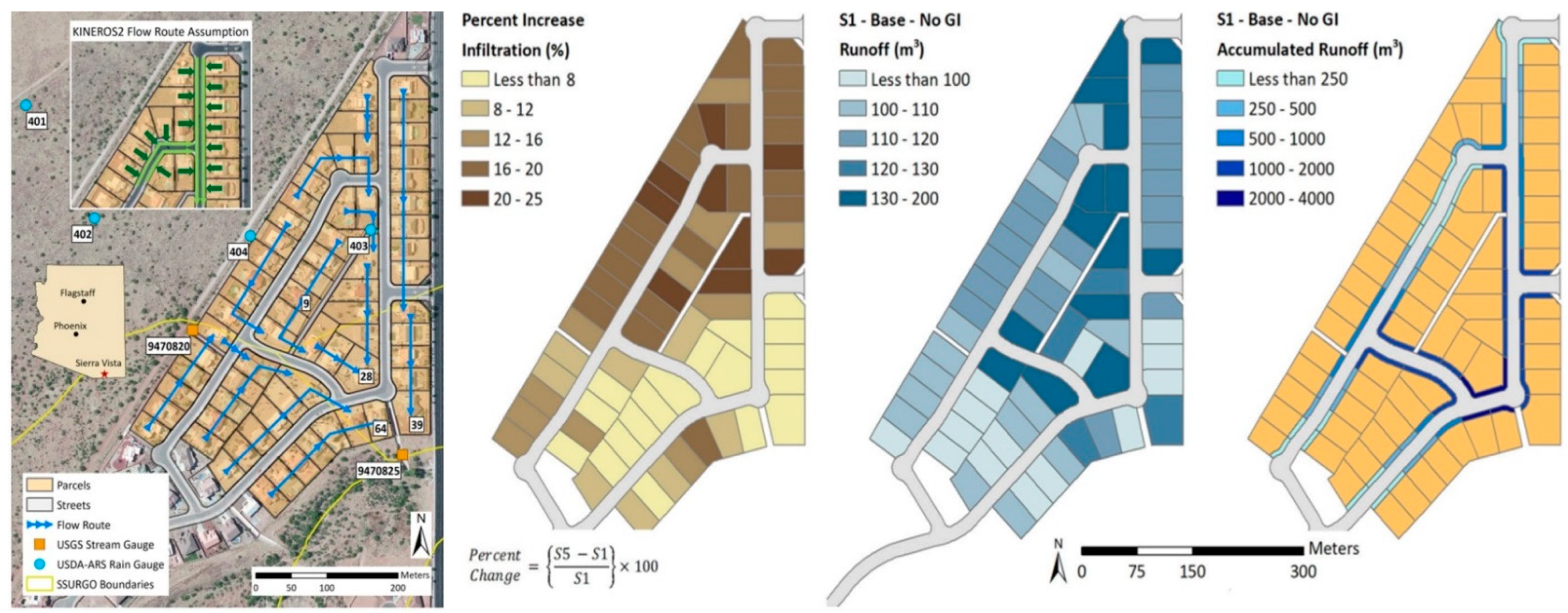
  51. Korgaonkar, Y.; Guertin, D.P.; Goodrich, D.C.; Unkrich, C. Modeling Urban Hydrology and Green Infrastructure Using the AGWA Urban Tool and the KINEROS2. Model Front. Built Environ. 2018, 4, 58. [Google Scholar] [CrossRef]
  52. García-Valdecasas Ojeda, M.; Di Sante, F.; Coppola, E.; Fantini, A.; Nogherotto, R.; Raffaele, F.; Giorgi, F. Climate change impact on flood hazard over Italy. J. Hydrol. 2022, 615, 128628. [Google Scholar] [CrossRef]
  53. Cai, Z.M.; Han, G.; Chen, M. Do water bodies play an important role in the relationship between urban form and land surface temperature? Sustain. Cities Soc. 2018, 39, 487–498. [Google Scholar] [CrossRef]
  54. Chen, A.; Chen, X.A.; Yao, R.; Sun, L. Effect of urban green patterns on surface urban cool islands and its seasonal variations. Urban For. Urban Green. 2014, 13, 646–654. [Google Scholar] [CrossRef]
  55. Aletba, N.; Abdul Hassan, R.; Putra Jaya, E.; Aminudin, M.Z.H.; Mahmud, A.; Mohamed, A. Thermal performance of cooling strategies for asphalt pavement: A state-of-the-art review. J. Traffic Transp. Eng. 2021, 8, 356–373. [Google Scholar] [CrossRef]
  56. Green Peace. Reverdecer las Ciudades los Espacios Urbanos y su Impacto en la Salud y el Bienestar. Available online: https://es.greenpeace.org/es/wp-content/uploads/sites/3/2021/06/reverdecer_las_ciudades.pdf (accessed on 14 April 2023).
  57. Rodríguez-Rojas, M.I. Sistemas Urbanos de Drenaje Sostenible. Una oportunidad para la planificación de ciudades sensibles al agua. ROP 2019, 3607, 14–20. [Google Scholar]
  58. Perales-Momparler, S.; Andrés-Doménech, I.; Hernández-Crespo, C.; Vallés-Morán, F.; Martín, M.; Escuder-Bueno, I.; Andreu, J. The role of monitoring sustainable drainage systems for promoting transition towards regenerative urban built environments: A case study in the Valencian region, Spain. J. Clean. Prod. 2017, 163, 113–124. [Google Scholar] [CrossRef]
  59. CIRIA C723. Water Sensitive Urban Design in UK; CIRIA: London, UK, 2013. [Google Scholar]
  60. SUSDRAIN. Types of SuDS. Available online: www.susdrain.org (accessed on 2 February 2023).
  61. Van Mechelen, C.; Dutoit, T.; Hermy, M. Vegetation development on different extensive green roof types in a Mediterranean and temperate maritime climate. Ecol. Eng. 2015, 82, 571–582. [Google Scholar] [CrossRef]
Figure 1. Example of hydrological study: flow paths, runoff accumulations and infiltration [48].
Sustainability 16 02658 g001
Figure 2. Example of ‘river and lake streets’, connection of blue and green corridors [57].
Sustainability 16 02658 g002
Figure 4. Street design to improve rainwater collection and infiltration [58].
Sustainability 16 02658 g004
Table 1. Planning tools and scales of application in the case studies [44,45,46].
CityDistrictStreet
SpainP.G.O.U. 1P.P. 2P.U. 3
FranceP.L.U. 4P.D.Q. 5P.A.U. 6
ItalyP.R.G. 7P.D.L. 8P.D.U. 9
1 Plan General de Ordenación Urbana. 2 Plan Parcial. 3 Proyecto de Urbanización. 4 Plan Local d’Urbanisme. 5 Plan Directeur de Quartier. 6 Project d’Aménagement Urbain. 7 Piano Regolatore Generale. 8 Piano Di Lottizzazione. 9 Progetto di Disegno Urbano.
Table 2. Proposal for integrating SuDS into urban planning.
ScalesActionsUrban Plans
CityAnalysisSpain: P.G.O.U.
France: P.L.U.
Italy: P.R.G.C.
-Hydrological study; define flooding areas.
Planning measures
-Locate large green areas and multi-purpose spaces in flooding areas.
Regulation measures
-Establish a minimum ratio of m2 of permeable area per m2.
NeighborhoodAnalysisSpain: P.P.
France: P.D.Q.
Italy: P.P.
-Hydrological–hydraulic study; define blue corridors.
Planning measures
-Plan green corridors with SuDS.
-Modification of the blue corridors and connection to the green corridors.
-Involve stakeholders in the decision-making process.
Regulation measures
-Establish a minimum % of infiltration of urban runoff.
Street PlotAnalysisSpain: P.U.
France: P.A.U.
Italy: P.D.U.
-Hydraulic study; define slopes and flow directions.
Planning measures
-Design road and pavement slopes to direct water to infiltration areas.
-Convert building roofs to green roofs.
Regulation measures
-Establish a minimum % of collected runoff water to be reused.
Disclaimer/Publisher’s Note: The statements, opinions and data contained in all publications are solely those of the individual author(s) and contributor(s) and not of MDPI and/or the editor(s). MDPI and/or the editor(s) disclaim responsibility for any injury to people or property resulting from any ideas, methods, instructions or products referred to in the content.

