


Urban Revitalization in Small Cities across the Atlantic Ocean

Independent Researcher, Albany, NY 12203, USA
†
Formerly with the School of Architecture and the Built Environment, Ulster University, Belfast BT15 1ED, UK.
Sustainability 2024, 16(2), 639; https://doi.org/10.3390/su16020639
Submission received: 16 November 2023
/
Revised: 20 December 2023
/
Accepted: 28 December 2023
/
Published: 11 January 2024
(This article belongs to the Special Issue The Sustainable Development of Villages and Small Towns under the Situation of Population Contraction)
Abstract
:City centers and riverfronts across the Atlantic Ocean have undergone substantial transformation over the last two decades. This paper analyzes walk-only precincts and waterfront revitalization in two pairwise cases (PCs) of small city exemplars on two continents in locations at about the same latitude but separated by the Atlantic Ocean. The argument is twofold. First, to be fully effective, city center revitalization interventions need to be coordinated with appropriate institutional programs to create collaborative management opportunities among multiple civic and business agents. Second, multiple cultural offerings, environmental amenities, and pro-active leadership positionalities have contributed positively to the evolution of waterfront community economic redevelopment opportunities in riverfront locations. The methods involved multiple site visits to cities of various sizes on the Iberian Peninsula and the Northeast of the United States at different times during the last twenty years, extensive literature reviews and syntheses, data analyses, assessment of policy priorities, and interviews with employees in various economic sectors, business owners, residents, elected officials, planning professionals, and community leaders. Two of the main conclusions are that, to be fully effective, the public space interventions on the Iberian Peninsula had to be coordinated with appropriate regulatory and institutional programs to generate collaborations with multiple civic and business agents and that the Northeastern cities have attempted to revitalize their riverfronts by conserving water-based and urban historic assets and amenities from further erosion due to downpours and floods as well as socio-economic and cultural transformations.

1. Introduction
Most city centers on the Iberian Peninsula are several centuries old and have had an outstanding history easily realized by their patrimonial heritage and usually vibrant socio-economic nature [1,2]. Multiple layers of urbanity and architectural influences and styles are easily observed in most cities. Many Spanish and Portuguese city centers in the northern Iberian Peninsula are characterized by their narrow streets, plazas, and courtyards, and in other cases also by either their hillside or riverfront locations [3,4,5]. Many Spanish cities possess a plaza mayor, which traditionally has resulted from the redevelopment of its centrally located built environment [6].
Iberian Peninsula city centers still tend to concentrate social, economic, administrative, and cultural activities, despite suburbanization trends over several decades [7,8,9]. Their historic centers have been the location of important activities (i.e., seats of government, churches and cathedrals, judicial courts, public markets, and retail establishments) [10,11]. As a result of a more pleasant climate, and contrarily to cities in Northern Europe, cities on the Iberian Peninsula hold and regularly promote open-air activities in spring, summer, and autumn, which contribute to high levels of sociability and conviviality [12,13].
In the last five decades, suburban sprawl development, consisting of residential subdivisions, roads, highway interchanges, and peripheral commercial development, has contributed to expansive growth centered on new suburban functions and lifestyles [14,15,16]. A strong real estate sector and a pro-growth business mentality was partially responsible for city growth [17]. City centers were regenerated with support from European Union funds and contributions from property and business owners [18,19]. Public spaces were redesigned and improved for walkability, while parking garages enabled automobile-centered mobility. Many commercial establishments in central locations either closed or were modernized to face the increased competition from larger stores in peripheral locations [20,21]. Walk-only districts in historic centers not only enable people to roam free but also reduce and, in many cases, eliminate collisions between people and motorized vehicles [22,23].
Across the Atlantic Ocean, many North American cities have developed on waterfronts, and some of their most notable urban fabric faces water bodies, such as oceans, rivers, canals, creeks, and lakes [24,25,26]. As cities grow and other neighborhoods become more preeminent, reserved canal spaces on the waterfront are occupied by roads and bypasses, severing a city from the water’s edge while also reducing the potential of their aesthetic and recreational amenities [27,28,29]. Inland cities have had a relatively different evolution than their oceanside counterparts since some of their waterfront industrial properties have been preserved and adapted to new uses [30]. Tourism activities have taken advantage of these locations with many recreational activities, which promote cultural, sports, and community-oriented open-air events on the water–land interface [31,32].
This paper aims to examine urban revitalization potential in small cities across the Atlantic Ocean: commercial urbanism on the Iberian Peninsula and riverfront revitalization in the Northeast of the United States (Figure 1). Commercial urbanism is utilized to discuss the impact of walk-only precincts on the livability and conviviality of central city neighborhoods. I also analyze the benefits and inconveniences brought forward by those commercial urbanism interventions to distinct city users. The first thematic part of the paper is confined to these two research questions: (i) Are the intended advantages of the commercial urbanism interventions maintained after the conclusion of the public works and modernization actions? (ii) Besides the obvious increases in comfort and safety for residents, workers, and visitors, does retail and services activity prosper equally from the revitalization activities? Across the Atlantic Ocean, the paper analyzes how riverfront cities have been attempting to promote active uses of their waterfronts. Tourism, water sports, and recreation activities have been encouraged in places with a critical mass of cultural heritage and adequate facilities on the land–water interface. In other cases, real estate redevelopments have brought new life to riverfront locations. The research question guiding the riverfront revitalizations is to what extent two distinct waterfront models have brought about relatively similar benefits to their city regions.
This paper also aims to be a significant contribution to the study of Sustainable Development of Villages and Small Towns across the Atlantic Ocean. As small cities become more isolated due to shrinking tendencies and their built environment and infrastructure remain underutilized and eventually collapse, their living conditions become more unsustainable due to higher levels of decline and higher per capita maintenance costs. As climate change-induced phenomena intensify, riverfront areas tend to either lose some of their natural and built heritage or spend higher amounts of money adapting their riverine places to new conditions. As such, the paper’s objective is not to compare the Iberian cities with their Northeastern counterparts but to utilize two pairwise cases (PCs) to examine two urban revitalization models with different foci in hopes of identifying lessons learned that can be helpful to other communities undergoing similar transformations.
PC#1 consists of two cities: Viseu in Northern Portugal and Benavente in Northern Spain, both of which are utilized to examine urban revitalization centered on the construction of walk-only precincts. PC#2 consists of two cities in New York State: Kingston, bordering the Hudson River, and Schenectady, located on the Mohawk River, both of which were chosen to analyze riverfront revitalizations in the Northeast region of the United States. The four cities were selected based on their size, ranging from 17,000 in Benavente to 67,000 in Schenectady, according to the most recent population censuses, as well as the author’s earlier thematic research engagements and study visits since the mid-2000s.
The argument is twofold. First, to be fully effective, city center revitalization interventions need to be coordinated with appropriate institutional programs to create collaborative management opportunities among multiple civic and business agents. Second, multiple cultural offerings, environmental amenities, and pro-active leadership positionalities have contributed positively to the evolution of waterfront community economic redevelopment opportunities in riverfront locations.
The paper’s methods comprised multiple site visits to cities of various sizes on the Iberian Peninsula and in the Northeast of the United States at different times during the last twenty years, extensive literature reviews and syntheses, data analyses, assessment of policy priorities, and interviews with employees in various economic sectors, business owners, residents, elected officials, planning professionals, and community leaders. The next section is the theoretical framework and contextual evolution.
2. Theoretical Framework and Contextual Evolution
2.1. Cities on the Iberian Peninsula
The Commercial Revitalization Vibrancy (CRV) theory [21] has been developed and applied by the author to analyze urban revitalization interventions in multiple locations across the Atlantic Ocean. Said theory not only places emphasis on the centrality of walk-only precincts but also tests how those precincts fare in terms of city center livability and how they relate to other neighborhoods in the city region under study. It is rather well accepted that many cities on the Iberian Peninsula have centuries-old urban morphologies that have evolved according to man-made decisions, wars, invasions, natural catastrophes, and, more recently, rapid urban and metropolitan growth due to motorized transportation patterns and lifestyles [3,36]. Most cities in the northern Iberian Peninsula are relatively distinct from the southern ones in the sense that they have expanded beyond city walls, and many of those walls were demolished without the recommended historic conservation efforts. The structure of many of those cities and towns was based on the Cardo and Decumanus arrangement of streets and urban agglomerations commonly built throughout the Roman Empire [21]. Such a pattern remained in place during the Middle Ages, with little development happening outside of city walls. In other cases, cities developed according to two typologies: one inside the fortified walls and the other outside. Many cities still present traces of 17th- and 18th-century Renaissance influences shaped by the maritime discovery enterprise, of which spices from Asia and gold and silver from Brazil constituted the major commercial commodities. Lisbon’s city center was rebuilt according to functionalist patterns in the 18th century with funds donated by the city’s merchants [21]. Ildefonso Cerda’s 1859 plan for Barcelona, almost a hundred years later, was proposed based on similar urbanistic principles of the modern city [37].
The cities of Évora and Silves in Portugal and Málaga and Seville in Spain reflect Arabic influences in settlement patterns and in the architecture of the built environment, which were highly influenced by an extremely mild Mediterranean climate [38]. The late-20th-century urban development of large polycentric cities was a result of the expansion of rail and highway technologies. The resultant urban form was shaped by peripheral mono-functional neighborhoods and the emptying out of central city areas [39,40]. Although the dictatorial and authoritative top-down regimes served to prevent excessive suburban development in peripheral areas of cities, those effects disappeared once the political regimes were changed and both Portugal and Spain joined the European Union in 1986. With the EU’s pro-growth and pro-territorial cohesion policies, joining resulted in spread-out and sprawling developments, especially in the suburbs of large metropolitan areas [41,42].
The high levels of highway construction in both countries during the 1990s and early 2000s facilitated the development of peripheral urbanized areas with the consequent destruction of many fertile agricultural farms, which helped to feed the urban populations of the large cities [43]. Such growth has been variously documented in studies on the expansive and spread-out growth of Mediterranean cities. The more recent morphological changes in the cities of the Iberian Peninsula were a direct consequence of expansions in the road network as much as dramatic increases in automobile ownership [36].
The decline of historic districts and downtown areas has led to conservation planning and heritage preservation movements and to the designation of certain historic districts as UNESCO World Heritage sites in both Portugal and Spain [44]. A certain emphasis on renovating single buildings, monuments, and public spaces has eluded the need to renovate the urban fabric in centrally located residential neighborhoods. Many of these neighborhoods were impacted negatively by stagnant rents and property values imposed during the dictatorship regimes and immediately afterwards. Urban revitalization and environmental regeneration programs during the last twenty years have contributed to the partial reversal of this tendency [21,45,46].
Commercial urbanism interventions and several mega events have helped to improve city center shopping districts on the Iberian Peninsula. Commercial development has evolved from small traditional establishments to shopping centers, outlets, discount stores, and internet shopping [47]. The primacy of retailing along the high street and in public markets was widespread throughout the two countries until changes in the retail sector reached Southern Europe around the time of Portugal and Spain joining the European Union [20,48]. Cities in metropolitan areas were the first to promote the latest retail innovations [49]. After a certain saturation of those areas, and usually as part of diversification strategies, shopping mall developers began targeting regional cities in the countryside [50]. The first retail planning measures comprised normative interventions, such as quotas for the opening of new shopping centers over a certain floor area, and the regulation of retail trade schedules of hypermarkets and large shopping centers [51].
In Portugal, the management of open-air shopping areas in central locations, following their subsequent physical urban design improvements, was limited in scope and results [21]. Despite training programs fostered by trade organizations, appointed city center managers lacked the political clout and the funding allocations needed to implement continued management, animation, and promotional actions [52,53]. In Spain, the philosophy of the centro comercial abierto (CCA) has been implemented with different degrees of success [54,55]. The combination of commercial urbanism projects with broader urban regeneration initiatives was relatively successful [56]. Spain has striven to be part of European efforts and professional networks of city center management since the first commercial urbanism projects were featured at one of the first city center management congresses in Málaga in the late 1990s [18,57].
2.2. Cities in the Northeast of the United States
Many cities developed on waterfronts because said locations have enabled them to grow and flourish. Water use facilitated the transportation of people and goods [58]. Water was also utilized in productive industrial uses, and waterbodies received water runoff and untreated discharged effluents from industry and human activities [59,60]. The variety of activities on those waterfronts is quite diverse [28]. Small and medium-sized cities may have more localized social relationships of proximity than large ones. The literature on waterfront processes and recent attempts at revitalizing land–water interfaces in large cities is vast and relatively accessible [24,29]. However, the literature on small and medium-sized cities [61], especially in the Northeast of the United States, is modest and mostly restricted to analysis of environmental accounts, technical processes, and watershed management [30,62,63].
Subsequently, I review three theoretical strands of literature on waterfront revitalization: (i) historic preservation and conservation, (ii) riverfront greenways, and (iii) waterfront redevelopments. This continuum ranges from the existence of urban assets, such as buildings, piers, wharves, and discharge infrastructure, to waterfront locations set aside mostly for roadway and railway infrastructure and limited leisure-oriented amenities on low-lying margins utilized for a multitude of purposes. Culture, utility, and environmental values differ considerably in these three strands. Localized developmental processes, public policies, the relative number of urban and natural assets, the (in)existence of interest groups and their commitment to preserving historic and natural resources, and the natural and weather conditions of a region all influence the degree of waterfront utilization.
The historic preservation of waterfront resources augments the urbanity potential of an area [27]. Urban relics from working harbors, many transformed by containerization, transshipment canals, loading and unloading docks, piers, warehouses, storage silos, repair docks, moving cranes, and stevedoring paraphernalia, have given place to recreational and tourism-related activities, such as bars, restaurants, shopping centers, museums, and art galleries [25,64]. Easily accessible waterfronts tend to be well connected to various parts of a city, including downtowns and other mostly commercial and formerly industrial neighborhoods [65].
The second strand of literature pertains to the use of linear or canal spaces along waterbodies, rivers, lakes, and oceans. Their almost uninterrupted continuity and low levels of topographic barriers enable land transport systems to be built and maintained quite easily and, in certain cases, to be expanded through redevelopment interventions. In certain cases, their location in flood-prone areas is a liability occasionally overseen by those in charge of operating such systems. The building of multi-use trails along waterbodies presents fewer risks and guarantees enjoyable greenway amenities for residents and visitors alike [66,67].
The third strand encompasses literature on the active redevelopment of waterfront sites [32]. One ought to recognize that, in the past decades, little-regulated industrial processes and lack of an appropriate normative environment led to the contamination and pollution of many waterbodies [63,68]. The deindustrialization of the economy in the Northeast of the United States and the promulgation of multipronged legislative frameworks covering land, water, air, and sound, as well as the requirement to conduct environmental and social impact studies [69] and to devise and implement climate change mitigation and adaptation strategies, has drastically changed how stakeholders perceive and relate to waterfronts [70,71]. Cleaner and greatly decontaminated waterbodies are used for a variety of functions, including aquatic sports and recreation. If, decades ago, riverfront locations presented risks that tended to lower the urban development potential of a neighborhood, nowadays we observe attempts at utilizing proximity to the water not only as an economic locational advantage but also as a redevelopment strategy sought after by entrepreneurs catering to the needs of a more environmentally conscious population [58,72]. Voluminous real estate developments tend to charge a premium for scenic vistas of water and ecologically sensitive landscapes as well as proximity and, in many cases, direct access to those resources [17]. In the Northeast of the United States, there are emblematic examples of these three literature strands, with slightly different degrees of success. Box 1 characterizes the paper’s two-type conceptual framework while providing a brief overview of their contextual evolution on the Iberian Peninsula and in New York State.
3. Exemplar Cases
3.1. PC#1 Northern Iberian Peninsula Cities
The exemplars for this paper were pre-selected based on a combined record of best practices in commercial urbanism projects and patrimonial heritage conservation. The preservation of their historic districts was also a major goal in regional and revitalization plans. The Viseu Dão-Lafões is in the north-central region of Portugal. The Autonomous Region of Castilla y León constitutes the largest autonomous region in Spain. Although the Dão-Lafões region has been growing demographically, the province of Castilla y León has been experiencing strong aging and the loss of population, with an unequal distribution of its inhabitants and the emptying of its rural environment. The main city in the Viseu Dão-Lafões region has an 18th-century cathedral on the city’s highest point and several other important architectonic buildings located along the city’s oldest arterial street [73]. The Rua Direita has distinct establishments selling everything from apparel to personal products. The city has been shaped by a Roman wall, good communication networks, and weekly and annual open-air medieval fairs. The construction of several tertiary sector developments in the suburbs has considerably weakened the businesses located in the city center. Examples of these developments include the hospital, a regional-scale shopping center, and a college campus [43].
The Spanish exemplar, the city of Benavente, is in the province of Zamora in the Autonomous Region of Castilla y León [74]. The agglomeration is located on top of an incline in the middle of an extensive agricultural area in the internal plateau and accessible by a highway. The city’s historic district is relatively flat, making it very walkable. A considerable number of streets in the center were pedestrianized decades ago. Vehicular movement on the historic district’s walk-only streets is allowed during restricted times on weekdays and Saturdays.
Box 1. Two-type conceptual framework and contextual evolution.
| Waterfront Planning | Walk-Only Precincts |
| New York’s coastlines are quite unique and the state’s water resources are mostly concentrated on the Atlantic Ocean, Lake Erie, and in three important river watersheds—the Saint Lawrence, the Mohawk, and the Hudson—and in a high number of inland lakes and ponds, such as Lake Placid in Upstate NY and the Finger Lakes in the western part of the state [75]. New York City (NYC), a truly global city, developed on the Hudson River estuary several centuries ago [26,76]. The city’s proximity to the ocean constituted a major locational advantage for commerce and the flourishing of industry, services, and entertainment. NYC’s territorial development has impacted land use and transportation options in the Lower Hudson. The pattern of development in the middle and upper sections of the Hudson River Valley is marked by small and medium-sized towns and cities, interspersed mostly by farms and Industrial Age structures [77]. Concerns about urban sprawl are real and have led to major institutional attempts at preserving the scenic and environmental integrity of the region [78]. Many small cities, towns, and villages have been impacted by growth and declining forces. Others, once desolated and amid shrinking tendencies, are now being rediscovered due to their ambiance, cost of living, and proximity to other regional assets and amenities [79]. In terms of planning, the home rule approach to community affairs has been quite prevalent and is usually responsible for the boons and ills of a place. A city’s comprehensive plan, zoning regulations, and a panoply of volunteer boards, including planning and zoning boards of appeals, tend to influence the type of development a city undertakes. The region is also influenced by supra-local, state, and federal regulations. Preeminent among these is the Hudson River Valley National Heritage Area, designated by Congress to conserve the significance of the cultural and natural resources of the Hudson River Valley [80]. A local waterfront revitalization program is aimed at supplying communities with the necessary expertise and technical and financial resources to plan, improve, and conserve their waterfront areas [62]. | The urban morphology of most Iberian city centers has enabled the creation of walk-only precincts in many historic districts [40]. Southern European cities and towns saw an increase in the number of this type of district during the 2000s [21]. The emphasis on creating city center walk-only areas has resulted from the need to improve and maintain public spaces and their adjacent urban fabric [81]. The decline of city centers was due to structural reasons, and the responses, despite, in most cases, being holistic and comprehensive in nature, have taken time to produce results [1,82]. The appeal of peripheral shopping areas, the ease of parking, and the combination of retail with office and leisure activities has had distinct impacts depending on the relative hierarchy of the cities, their regional competition and governance practices, and the leadership efforts of their elected officials [83,84]. Certain cities have simply widened sidewalks to create more comfortable areas for people, whereas others have either partially or fully closed one or several streets in their cores not only to accommodate passers-by but also to enable greater utilization of their newly created public spaces. Others have restricted vehicular speeds, adopted mini-buses, revamped public transit with alternative fuels, and implemented traffic-calming schemes aimed at controlling traffic volumes and preserving neighborhood characteristics [85]. Walkability has remained a very important and desirable characteristic in both old and new cities [86]. Universal design has been more than an election campaign tagline. Multiple associations have created plans, programs, and campaigns to reduce mobility barriers for people with disabilities [87]. Plazas Mayores in many Spanish cities hold an important identity, character, and meaning in the built environment and in Iberian culture. The most vivid and easily observable functional change besides walk-only precincts has been accomplished with the installation of traffic pillars to prevent automobiles from parking illegally on the sidewalk, obstructing people’s right to walk safely [23,88]. |
This enables deliveries to the local commercial establishments to be made in a less obtrusive manner. As was verbalized by an interviewee, the establishments located on the walk-only streets cater mainly to a local clientele, and the unique, relatively isolated, regional setting tends to limit the commercial establishments’ hinterland. There is also a system of card-activated bollards to allow residents to enter the cordoned-off area. The City Hall and the local tourism office are located on the Plaza Mayor [89]. The city has an important public space overlooking the fertile valley below. The newer and wider streets structure the expansion areas at the bottom of the hill. The regional bus station, with daily service to other cities throughout Spain, is an important hub in the city.
3.2. PC#2 Northeastern US Cases
The Northeastern US exemplars discussed here illustrate some of the waterfront models identified in the literature review. They are not exhaustive of a wide range of cities. Their sui generis characteristics and historic evolution serve to discuss their current development efforts and programs. The city of Kingston, located in Ulster County, has had a stable population of around 24,000 people since the early 2000s, whereas the city of Schenectady, located in Schenectady County, lost nearly one-third of its population between 1950 and the late 20th century, recently stabilizing around a figure of 65,000 people. These two exemplars have benefited from waterfront planning and recent historic conservation efforts. The cultural heritage of the city on the Hudson River, Kingston, was a direct consequence of its former state capital status. Upstate New York was a bastion during the Industrial Revolution, with various commanding important manufacturing plants [90]. Schenectady, the city on the Mohawk River, was even known as “the city that lights and hauls the world”. Such economic progress led to key cultural and economic developments, such as banks, theaters, public buildings, and residences. Water resources have partially enabled the flourishing of these exemplars. They both benefited from their proximity to the Delaware and Hudson (D&H) and the Erie canals, respectively [62].
The Roundout Creek waterfront district is one of four historic districts in the Hudson River exemplar. The city’s settlement structure upwards from the Hudson River and collection of historic buildings and monuments in public spaces uncovers the prosperity resulting from having served as an important trade and administrative center [77]. Although the main urban agglomeration is located uphill from the riverfront, the small waterfront historic district, though partially demolished during the 1960s urban renewal movement [91], has benefited from continued attention, proactive and incremental planning, and participated collaborations between several public and private entities [30]. The riverfront area has suffered from climate change-induced floods, rising sea levels, and torrential downpours, making riverfront planning of utmost importance to preclude further damage associated with other impending weather-related episodes.
The exemplar on the Mohawk is paradigmatic of a Northeastern US city that prospered from industrial development and now is in the process of adjusting to a new demographic and economic trajectory centered on services, tourism, and entertainment as its new economic engines [92,93,94,95]. The city itself is located near the confluence of the Mohawk and Hudson rivers. The Mohawk River Waterfront Revitalization Plan covers the exemplar’s entire county and was jointly developed by six communities, comprising various towns, one county, one city, and one village [96]. The waterfront is about 3.2 km long. Besides the Stockade neighborhood, located directly on the Mohawk River; a community college; and a small park, the city did not have much of a relationship with the river [97]. However, the exemplar’s waterfront has recently experienced a major redevelopment, with the construction of a casino, a hotel, and a small marina just east of the city’s historic Stockade district. The recent investment in the waterfront has contributed to the creation of new jobs and to attracting visitors to the city, which indirectly is expected to also have a positive impact on the local economy [98].
4. Pairwise Case Discussions
4.1. PC#1 Northern Iberian Peninsula Cities
The two northern Iberian Peninsula case studies can be analyzed in terms of the eight main precepts of the Commercial Revitalization Vibrancy (CRV) theory deemed important when analyzing walk-only precincts [21,22]. The following two questions are important in this discussion: (i) Are the intended advantages of the commercial urbanism interventions maintained after the conclusion of the public works and modernization actions? (ii) Besides the obvious increases in comfort and safety for residents, workers, and visitors, does retail and service activity prosper equally from the revitalization activities? Table 1 presents a synthesis of the northern Iberian Peninsula cases to help structure the discussion of PC#1.
These walk-only pedestrian precincts are in historic districts (Figure 2 and Figure 3). They constitute a combination of interconnected streets, squares, and alleyways. The walk-only streets in the Portuguese exemplar (Rua Direita and Rua Formosa) are much narrower than the two Spanish ones (Calle de los Herreros and Calle de la Rúa). This is partly explained by the era in which those centers were built; by each city’s urban morphology; in the Portuguese case, by the city’s topography; and finally, also by the degree of urban redevelopment or renovation experienced over the years. A comparative analysis of the exemplars’ demographics shows that the Spanish city is a small agglomeration with a rather low urban density. The two city centers have experienced different demographic trends as a direct result of residential, commercial, and service dynamics and preservation policies [99,100]. The urban form of each city partially explains their fundamental socio-economic trends. Although neighborhood blocks in the Spanish cities are relatively regular, allowing for modern living conditions, such is not the case in the Portuguese historic district. The length of the pedestrianized streets also varies from short streets and courtyards to the high streets, which, in the case of Rua Direita, represents the longest medieval street in the city. Due to traffic circulation patterns, Rua Direita is fully walkable but still open to vehicular movement in certain segments. The relationship between the streets and the surrounding areas enhances and conditions the functional uses in the adjacent urban fabric. Streets were closed to motorized movement to create better walking conditions for everyone. The criteria included a combination of commercial or civic uses on the ground floors and the elimination of safety concerns. Accessibility to the walk-only precincts varies from unrestricted in the Portuguese case to restricted in certain streets of the Spanish case [89]. The most common feature used to control access to the pedestrian precinct is a bollard system activated by a user’s card, which grants vehicular access to the restricted area. An interviewee confirmed the author’s observation of the value of traffic-calming improvements on several streets surrounding the historic center, with narrower travel lanes protected by short metal bollards to prevent the abusive invasion of sidewalk space by automobiles.
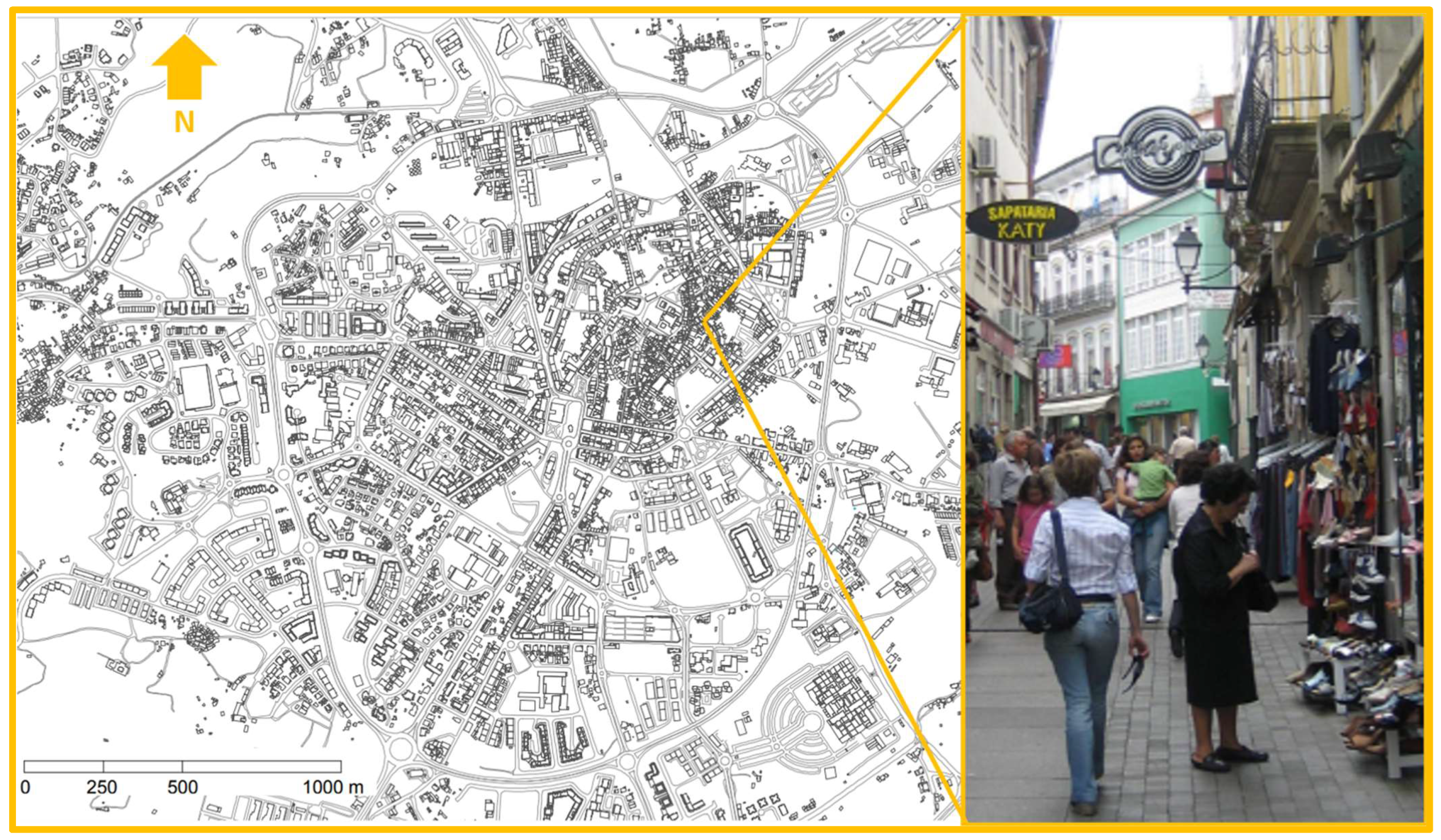
Figure 2.
Walk-only street in Viseu, Portugal (base map and photo courtesy of [101] and author, respectively).
Figure 2.
Walk-only street in Viseu, Portugal (base map and photo courtesy of [101] and author, respectively).

Another common measure in these pedestrian precincts is the existence of parking garages or on-street parking in the immediacy of the precincts. Also, there are public transportation stops and mass transit stations near the precincts. Finally, these cities also regulate the delivery of goods to the commercial establishments located along the pedestrian streets. The conciliation of the needs of different street users in most cities has been accomplished using different pavement materials and design features to create distinct, at level, paths for different users. There have been critical observations of the extensiveness of the walk-only areas, mainly in the Spanish case. There is little doubt that once the commercial urbanism interventions are implemented, city centers become more attractive for shoppers and the population in general. The common criticism that the improvements have influenced automobile-dependent shoppers to go elsewhere often results from a combination of more diversified and appealing retail offers in other locations [50,83].
Regarding whether retail and services prosper equally from the revitalization activities, it is important to recognize that commercial establishments located in city centers must still compete with stores located in peripheral shopping centers. Variations in sales might not be directly attributed to the closing of streets to motorized vehicles but to a combination of internal and external factors, such as quality and variety of goods, prices, retail schedules, capacity to haul away, lifestyle changes, disposable income, accessibility, parking, and the presence or lack of specific amenities. A decrease in the number of retail establishments on Rua Direita from 142 to 92 during the period of 2001–2012 has been documented [102].
The impacts on shopping can be assessed through a combination of sales volumes, store turnover, property rents, and duration of commercial activity. The walk-only spaces can either supplement or constrain certain activities in the adjacent built environment. Each effect varies for different types of commercial activities [103], and even for the same type of activity it depends on where on the street the activity is located, as well as on the density and characteristics of the surrounding activities. The improvement of buildings, streets, and squares is the visible part of the urban revitalization [104]. A measure of success of walk-only precincts is their footfall, which certain cities care to monitor over time. In many Iberian cities, official walking figures at the municipal level show that the walking mode share has been decreasing over time, perhaps due to growing automobile ownership and usage [36]. It is accepted that simply replacing the pavement is no guarantee that additional people will flock to the commercial precincts. The activities in the built environment and the mixing of multiple sectors of activity are what attract people to city centers [10,22].
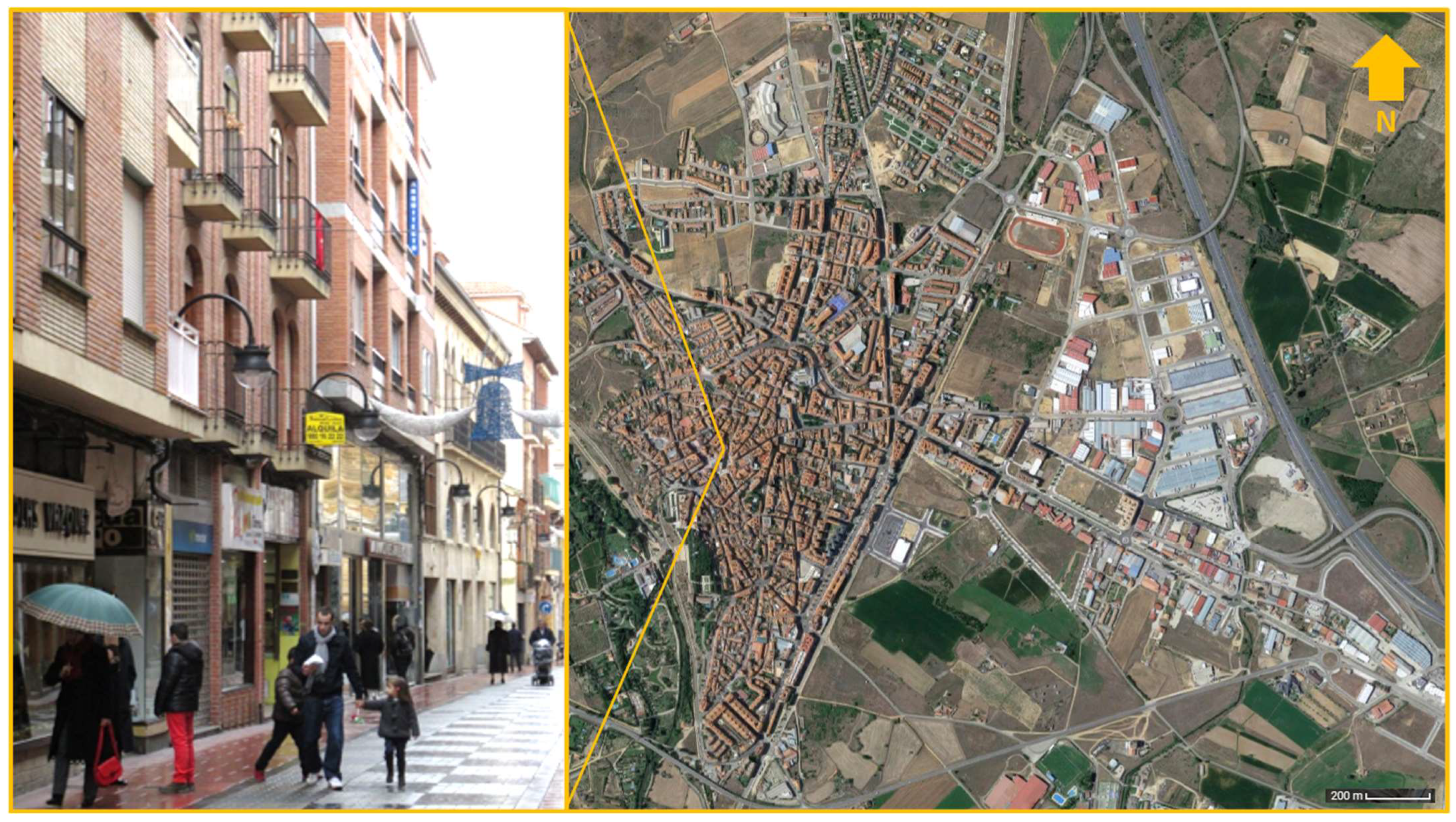
Figure 3.
Walk-only street in Benavente, Spain (photo and aerial image courtesy of author and [105], respectively).
Figure 3.
Walk-only street in Benavente, Spain (photo and aerial image courtesy of author and [105], respectively).

The commercial urbanism projects included an animation component that ranged from fashion shows to holiday season fairs to street performances to many other regularly held festivals and cultural events [106,107]. In addition to examining the direct and indirect impacts on retailing, one can also examine the other activities that are being implemented to respond to added competition from new and emerging centers. Public art, street furniture, maintenance of important public and non-profit institutions in city center locations, residential renovations, modernization of retail establishments, and the installation of cultural facilities such as museums and municipal art galleries, in addition to training and business acumen workshops and capacity building for retailers, have been devised and implemented over the years to different degrees of success in the two cases [89,108].
Walk-only streets are regulated by municipalities [22]. These jurisdictions are responsible for their construction, maintenance, circulation patterns, and overall utilization by multiple publics. Streets have been closed to traffic, fully or only partially, because of public decisions recommended by technical advisors and approved by elected officials [101]. Residents and especially merchants and trade association leaders have lobbied municipalities to have certain streets closed to vehicular movement. In addition to their business activities, many merchants are politically active or have organized themselves independently to make their concerns and ideas heard by elected officials [109]. Acts of leadership by their elected officials and civic volunteers are critical to the success of city center revitalization efforts [53]. The Portuguese exemplar has created a technical advisory committee and an urban rehabilitation society to implement urban revitalization strategies [103]. Funding these activities usually has multiple sources, ranging from the European Union and national and local governments to the private sector. Certain funding arrangements paid only for capital improvements, whereas others paid for management, animation, and promotional activities [19].
The Portuguese embryonic management units and the Spanish centros comerciales abiertos (CCAs) are like many of their counterparts in Europe and North America [55], and as such, they also suffer from similar problems—mainly, the need to find creative ways to sustain and enhance the revitalization outcomes achieved in earlier interventions. Obtaining adequate funding for new projects has been a major barrier to their continued existence [54,110]. The lack of required contributions to pay for some of the improvements, animation, and promotional activities has drastically curtailed their effectiveness. Once the material improvements have been made to a city center, it is also understood that there is a change from mostly capital improvements to maintenance and promotional activities, which are relatively less costly than the former [57].
4.2. PC#2 Northeastern US Cases
The Northeastern US exemplars have long lived with the vicissitudes of the Hudson and the Mohawk Rivers and their tributaries [60,62,80]. The research question guiding the riverfront revitalizations is to what extent the two distinct waterfront models have brought about relatively similar benefits to their city regions. Table 2 is a synthesis of PC#2 in the Northeast region of the United States. The research on waterfront planning and redevelopment interventions shows that, depending on the waterfront locations, typologies, evolutions, urban intensities, vulnerabilities, and transformations, one is likely to encounter different streams of research [111]. The two most important factors for this research are the occupation and conservation of riverfront locations with built-up structures and active planning to prevent harmful actions due to flooding [60].
As was recognized above, shorelines are among the richest and most vulnerable areas of riverfront communities and often the centerpieces of cities [30]. Quite often, they are the scenes of their grandest architectural achievements and the location of the most valuable and attractive property [24,64]. Although the particulars vary, waterfronts are the products of local history and geography. Riverine cities have been changing because of the decline of inland ports and allied transport and industrial areas [26]. Demographic, socio-economic, and cultural decentralization processes have also contributed to these changes [112]. In many of these communities, these changes have created significant urban decline problems due to the abandonment and demolition of old piers, warehouses, and industrial, commercial, and even housing structures. Recent interests in the revitalization of waterfront areas are based on a new set of deeper and stronger economic values and forces that shape a new planning mentality, especially related to the creative economy [31,32].
Riverfronts and shorelines are critically important yet fragile places (Figure 4 and Figure 5). They are full of history and are very powerful representations of community culture. Built-up structures representing traditional architecture, fluvial artifacts, and natural environments, unique landscapes, and still-vital socio-cultural and economic practices can be found in Kingston, New York [113]. Integrated and proactive conservation has been introduced in planning and governmental practices at multiple levels. The responsibility for the historic preservation of waterfront communities lies with all interested parties. Collective preservation actions tend to achieve better results when an entire community supports them. Collaborations between the public and private sectors have been crucial to their success. Horizontal and vertical integration and collaboration between governmental entities and different sectors of the society have also brought many benefits. Bottom-up preservationist movements have happened at length in the Hudson River exemplar [62].
However, riverfront communities must have a strong planned sense of direction if they want to remain economically and culturally important. New York peculiarities, such as legal and fiscal contexts and an urban history shaped by the federal urban renewal program, have limited the way preservation works have been conducted. These basic intervention strategies are usually available to public bodies: direct government ownership and operation of heritage facilities, regulation, (dis)incentives, definition of property rights and provision of information [114]. At the local level, the integration of historic preservation goals and objectives in planning documents, volunteer cooperation agreements with historical societies and civic organizations, and educational campaigns can enable good results if they are complemented and coordinated with the interventions of different constituencies.
Waterfront areas have built-up structures that, in many cases, are marked with the imprint of hundreds of years of existence. Preserving the past can bring many benefits to cities and their regions: economic and social benefits from tourism and from a more heterogeneous population, and cultural benefits from its enhanced setting for artistic activity [94]. These various benefits have been proven to offset the costs of preservation. Conserving portions of the urban environment, which have patrimonial significance and historic authenticity, can provide the public with the sense of place that is often felt to be lacking in today’s cities [71]. Waterfront revitalization also requires important political and community commitments [65].
The two Northeastern US exemplars reveal distinct waterfront models that suit their unique locations. One cannot expect the same level of measurable benefits from different revitalization models. The Hudson River exemplar is centered on a historic preservation model that targets a clientele oriented towards cultural festivals and water-sports offerings in a relatively intimate setting [113]. The Mohawk exemplar is much more centered on a real estate waterfront redevelopment initiative and less on enabling an active use of the riverine resources [90] (Figure 5). To a certain extent, the distinct models do not compete amongst themselves but instead complement each other, with slightly different regional variations.
5. Conclusions and Lessons Learned
Commerce has occurred in central locations of cities since time immemorial [47]. The two northern Iberian Peninsula cities were established many centuries ago. Their settlement resulted due to civic, trade, and defense reasons. They have withstood the test of time. Some of their heritage has been preserved, and many of their functions are still in existence today. These two cities have attempted to bolster their urban revitalization potential through the implementation of a variety of commercial urbanism and public space redesign interventions in hopes that the benefits of their actions—propagated by a duality of regional and global forces—do not destroy their endogenous cultural heritage and legacies nor contribute to the further homogenization of cityscapes.
The first thematic part examined the impact of walk-only precincts on the overall city center livability of their respective cities. The main lesson learned is that, to be fully effective, those public space interventions need to be coordinated with appropriate regulatory and institutional programs, like the ones identified in the conceptual framework, which can generate collaborations with multiple civic and business agents. Central to the Northeastern US cases was an analysis of how two cities in two distinct watersheds have benefited and been hindered by the course of the Hudson and the Mohawk river flooding and inundation episodes and the steps taken to prevent further damage while helping to preserve urban and historic assets from further erosion due to socio-economic and cultural transformations.
The paper has identified three commercial urbanism lessons with relevant implications for similar realities. Firstly, neighborhood specialization might have detrimental impacts to a city’s overall downtown livability; in fact, such areas require planning interventions to minimize land use conflicts and abrupt changes in property values. Secondly, local governments are relying on their expertise, creative funding strategies, and established collaborations to maintain existing programs and eventually to start new ones. Thirdly, city scale, proactive collaboration, and political leadership are found to influence the dynamics of, complexities of, and opportunities for the continued success of commercial urbanism and place management projects [115].
Waterfronts are invaluable assets to their neighboring cities. Recent waterfront initiatives in the Northeast of the United States were reviewed in terms of their planning implications. The riverfront revitalization exemplars revealed two lessons learned. Firstly, regional contexts, a critical mass of cultural offerings, environmental amenities, and proactive leadership can impact the evolution of waterfront community economic redevelopment opportunities in riverfront locations [106]. Secondly, avoiding technical one-size-fits-all panaceas and instead utilizing technical solutions that reflect regional contexts and socio-economic evolutions that fit the specific needs of each waterfront, in addition to nurturing informed and participatory interventions, are the most critical recommendations for waterfront communities, especially those undergoing change due to simultaneously globalizing phenomena and shrinking tendencies.
Funding
This research received no external funding.
Data Availability Statement
Data are contained in the article.
Conflicts of Interest
The author declares no conflicts of interest.
References
- Pèrez-Eguiluz, V. El patrimonio urbano y la planificación. Interpretación de los conjuntos históricos de Castilla y Léon y sus instrumentos urbanísticos. Ciudades 2014, 17, 212–242. [Google Scholar] [CrossRef]
- Barata-Salgueiro, T. Shops with a history and public policy. Int. Rev. Retail. Distrib. Consum. Res. 2021, 31, 393–410. [Google Scholar] [CrossRef]
- Oliveira, V.; Medeiros, V.; Corgo, C. The urban form of Portuguese cities. Urban Morph. 2020, 24, 145–166. [Google Scholar] [CrossRef]
- Fernandes, J.; Martins, L. A área central dos aglomerados urbanos do Noroeste de Portugal. R. Fac. Let. 1988, IV, 33–52. [Google Scholar]
- Barrado-Timón, D.; Palacios, A.; Hidalgo-Giralt, C. Medium and small cities, culture and the economy of culture. A review of the approach to the case of Spain in light of international scientific scholarship. Sustainability 2020, 12, 7321. [Google Scholar] [CrossRef]
- Zerlang, M. Writing the City Square: On the History and the Histories of City Squares; Routledge: Oxon, UK, 2023. [Google Scholar]
- Tavares, A.O.; Monteiro, M.; Barros, J.L.; Santos, P.P. Long-term land-use changes in small/medium-sized cities. Enhancing the general trends and local characteristics. Eur. Plan. Stud. 2019, 27, 1432–1459. [Google Scholar] [CrossRef]
- Rocha, B.T. Long-run suburbanization trends in Portugal. Reg. Stud. Reg. Sci. 2022, 9, 513–515. [Google Scholar] [CrossRef]
- Escudero Gómez, L.A.; García González, J.A.; Martínez Navarro, J.M. Medium-sized cities in Spain and their urban areas within national network. Urban Sci. 2019, 3, 5. [Google Scholar] [CrossRef]
- Fernandes, J.A.R.; Sposito, M.E.B. (Eds.) A Nova Vida do Velho Centro, nas Cidades Portuguesas e Brasileiras; CEGOT: Porto, Portugal, 2013. [Google Scholar]
- Fernández, S.T. Los centros históricos de las ciudades españolas. Ería 2007, 72, 75–88. [Google Scholar]
- Worpole, K. Here Comes the Sun: Architecture and Public Space in Twentieth-Century European Culture; Reaktion Books: London, UK, 2000. [Google Scholar]
- Latham, A.; Layton, J. Social infrastructure and the public life of cities: Studying urban sociality and public spaces. Geogr. Compass 2019, 13, e12444. [Google Scholar] [CrossRef]
- Capel, H. Las pequeñas ciudades en la urbanización generalizada y ante la crisis global. Inv. Geogr. 2009, 70, 7–32. [Google Scholar]
- Benach, N.; Walliser, A. (Eds.) Urban Challenges in Spain and Portugal; Routledge: Oxon, UK, 2014. [Google Scholar]
- Marques da Costa, E. As pequenas e médias cidades portuguesas: Dinâmicas demográficas e funcionais nos últimos quarenta anos. In Sistemas Urbanos y Ciudades Medias en Iberoamérica; Maturana, F., Sposito, M.E.B., Bellet, C., Henríquez, C., Arenas, F., Eds.; GEOlibros: Santiago, Chile, 2017; pp. 258–299. [Google Scholar]
- Edkins, A.; Barnes, Y.; Grainger, A.; Chinowsky, P. Real Estate’s 21st Century Grand Challenges: The big issues and project management’s role. Eng. Proj. Organ. J. 2021, 10, 1–27. [Google Scholar] [CrossRef]
- Hurtado, S.G. Understanding the influence of EU urban policy in Spanish cities: The case of Málaga. Urban Res. Pract. 2021, 14, 419–444. [Google Scholar] [CrossRef]
- Chamusca, P. Urban planning and policy in Portugal: An overview on the role of EU funds and guidelines. Urban Res. Pract. 2023, 16, 44–65. [Google Scholar] [CrossRef]
- Balsas, C. Quality of life and city center commercial activity, a southern European study. Int. J. Iber. Stud. 1998, 11, 37–47. [Google Scholar]
- Balsas, C. Walkable Cities: Revitalization, Vibrancy and Sustainable Consumption; SUNY Press: Albany, NY, USA, 2019. [Google Scholar]
- Balsas, C. Exciting walk-only precincts in Asia, Europe and North-America. Cities 2021, 112, 103129. [Google Scholar] [CrossRef]
- Culver, G. Death and the car: On (auto) mobility, violence, and injustice. ACME 2018, 17, 144–170. [Google Scholar]
- Breen, A.; Rigby, D. The New Waterfront: A Worldwide Urban Success Story; McGraw-Hill: New York, NY, USA, 1996. [Google Scholar]
- Timur, U. Urban Waterfront Regenerations. In Advances in Landscape Architecture; Ozyavuz, M., Ed.; Intechopen: Rijeka, Croatia, 2013. [Google Scholar]
- Zimring, C.; Corey, S. (Eds.) Coastal Metropolis: Environmental Histories of Modern New York City; University of Pittsburgh Press: Pittsburgh, PA, USA, 2021. [Google Scholar]
- Balsas, C.; Kotval, Z.; Mullin, J. Historic preservation in waterfront communities in Portugal and the USA. Port. Stud. Rev. 2000, 8, 40–61. [Google Scholar]
- Yocom, K.; Andrews, L.; Faghin, N.; Dyson, K.; Leschine, T.; Nam, J. Revitalizing urban waterfronts: Identifying indicators for human well-being. AIMS Environ. Sci. 2016, 3, 456–473. [Google Scholar] [CrossRef]
- Avni, N.; Teschner, N. Urban Waterfronts: Contemporary streams of planning conflicts. J. Plan. Lit. 2019, 34, 408–420. [Google Scholar] [CrossRef]
- Eisenman, T.; Anzevino, J.; Rosenberg, S.; Spector, S. (Eds.) Revitalizing Hudson Riverfronts; Scenic Hudson: Poughkeepsie, NY, USA, 2010. [Google Scholar]
- Richards, G.; Duif, L. Small Cities with Big Dreams: Creative Placemaking and Branding Strategies; Routledge: New York, NY, USA, 2018. [Google Scholar]
- Üzümcüoglu, D.; Polay, M. Enhancing urban waterfront development: A groundbreaking framework for fostering creativity. GeoJournal 2023, 88, 6091–6104. [Google Scholar] [CrossRef]
- Thekingstonwaterfront.com. Kingston Waterfront—Our Neighborhood. Available online: http://thekingstonwaterfront.com/about/our-neighborhood/ (accessed on 25 February 2015).
- Alloveralbany.com. Schenectady Casino Project. Available online: http://alloveralbany.com/archive/2015/06/04/new-look-for-the-schenectady-casino-project (accessed on 25 February 2015).
- Available online: https://www.openstreetmap.org/ (accessed on 15 November 2023).
- Oliveira, C.S. (Auto)Mobilities and social identities in Portugal. Sociol. Probl. Prat. 2015, 77, 137–151. [Google Scholar] [CrossRef]
- Neuman, M. Ildefons Cerdà and the future of spatial planning: The network urbanism of a city planning pioneer. Town Plan. Rev. 2011, 82, 117–143. [Google Scholar] [CrossRef]
- Hakim, B. Mediterranean Urbanism—Historic Urban/Building Rules and Processes; Springer: Berlin/Heidelberg, Germany, 2016. [Google Scholar]
- Carvalho, J. Ordenar a Cidade; Quarteto: Coimbra, Portugal, 2003. [Google Scholar]
- Carvalho, J. Formas Urbanas; Edições Minerva: Coimbra, Portugal, 2009. [Google Scholar]
- Farrell, M. Spain and Portugal in the European Union: Assessing the impact of regional integration. J. South. Eur. Balk. 2005, 7, 409–415. [Google Scholar] [CrossRef]
- Vaz, D.; Nofre, J. Conhecimento, criatividade e novas dinâmicas urbanas: Repensar os territórios de baixa densidade em Portugal. Rev. Port. Estud. Reg. 2018, 49, 77–88. [Google Scholar] [CrossRef]
- Domingues, A. Cidade e Democracia: 30 Anos de Transformação Urbana em Portugal; Editora Argumentum: Lisbon, Portugal, 2006. [Google Scholar]
- Fernandez, Ó. Towards the sustainability of historical centres: A case-study of Léon, Spain. Eur. Urban Reg. Stud. 2007, 14, 181–187. [Google Scholar] [CrossRef]
- Moura, D.; Guerra, I.; Seixas, J.; Freitas, M.J. A revitalização urbana: Contributos para a definição de um conceito operativo. Cid. Comunidades Territ. 2006, 12–13, 15–34. [Google Scholar] [CrossRef]
- Peixoto, P. Requalificação Urbana. In Plural de Cidades: Novos Léxicos Urbanos; Fortuna, C., Leite, R., Eds.; Almedina: Coimbra, Portugal, 2009; pp. 41–52. [Google Scholar]
- Cachinho, H.A. O Comércio Retalhista Português: Pós-Modernidade, Consumidores e Espaço; GEPE: Lisbon, Portugal, 2002. [Google Scholar]
- Hubbard, P. The Battle for the High Street: Retail Gentrification, Class and Disgust; Palgrave MacMillan: London, UK, 2017. [Google Scholar]
- Farhangmehr, M.; Marques, S.; Silva, J. Consumer and retailer perceptions of hypermarkets and traditional retail stores in Portugal. J. Retail. Consum. Serv. 2000, 7, 197–206. [Google Scholar] [CrossRef]
- Saraiva, M.; Pinho, P. Spatial modelling of commercial spaces in medium-sized cities. GeoJournal 2017, 3, 433–454. [Google Scholar] [CrossRef]
- Guimarães, P. Revisiting retail planning policies in countries of restraint of Western Europe. Int. J. Urban Sci. 2016, 20, 361–380. [Google Scholar] [CrossRef]
- Grimmer, L. The role of local government in marketing small city retailing: Examining the gap between perception and reality. Int. Rev. Retail. Distrib. Consum. Res. 2023, 33, 371–395. [Google Scholar] [CrossRef]
- Kumar, T.; Stenberg, M. Why political scientists should study smaller cities. Urban Aff. Rev. 2023, 59, 2005–2042. [Google Scholar] [CrossRef]
- Frechoso-Remiro, J.; Villarejo-Galende, H. Town centre management at a crossroad in central Spain: Organizational challenges and the way of BIDs. J. Town City Manag. 2011, 2, 117–131. [Google Scholar]
- Callejo, A.B. Diagnóstico de los centros comerciales abiertos en las ciudades históricas. El caso de las ciudades patrimonio de la humanidad en España. Build. Manag. 2017, 1, 17–29. [Google Scholar] [CrossRef]
- Balsas, C. Historical and conceptual perspectives on urban regeneration: A prolog to a special issue. J. Place Manag. Dev. 2022, 15, 1–19. [Google Scholar] [CrossRef]
- Coca-Stefaniak, J.A.; Parker, C.; Quin, S.; Rinaldi, R.; Byrom, J. Town centre management models: A European perspective. Cities 2009, 26, 74–80. [Google Scholar] [CrossRef]
- Stein, C. Global Harbors: A Waterfront Renaissance—Documentary; Global Harbors Documentary, Inc: Baltimore, MD, USA, 2008. [Google Scholar]
- Short, J.R. The Urban Order: An Introduction to Urban Geography; Blackwell Publishers: Oxford, UK, 1996. [Google Scholar]
- Schuyler, D. Embattled River: The Hudson and Modern American Environmentalism; Cornell University Press: Ithaca, NY, USA, 2018. [Google Scholar]
- Bell, D.; Jayne, M. Small Cities? Towards a research agenda. Int. J. Urban Reg. Res. 2009, 33, 683–699. [Google Scholar] [CrossRef]
- New York Department of State. Guidebook: Making the Most of Your Waterfront; NYDS: Albany, NY, USA, 2009.
- Lifset, R.D. Storm King Mountain and the modernization of American environmentalism. In Coastal Metropolis: Environmental Histories of Modern New York City; Zimring, C., Corey, S., Eds.; University of Pittsburgh Press: Pittsburgh, PA, USA, 2021; pp. 84–97. [Google Scholar]
- Kotval, Z.; Mullin, J. Waterfront planning as a strategic incentive to downtown enhancement and livability. In Downtowns: Revitalizing the Centers of Small Urban Communities; Buraidi, M., Ed.; Routledge: New York, NY, USA, 2001; pp. 179–196. [Google Scholar]
- Jones, A.L. Regenerating urban waterfronts—Creating better futures—From commercial and leisure marketplaces to cultural quarters and innovation districts. Plan. Pract. Res. 2017, 32, 333–344. [Google Scholar] [CrossRef]
- Horte, O.S.; Eisenman, T.S. Urban greenways: A systematic review and typology. Land 2020, 9, 40. [Google Scholar] [CrossRef]
- Pileri, P.; Moscarelli, R. (Eds.) Cycling & Walking for Regional Development: How Slowness Regenerates Marginal Areas; Springer Nature: Cham, Switzerland, 2020. [Google Scholar]
- Thomas, T.A. Enduring rust: The persistence of low-tech pollution amidst New York’s high-tech revolution. Environ. Sociol. 2020, 6, 207–218. [Google Scholar] [CrossRef]
- Sairinen, R.; Kumpulainen, S. Assessing social impacts in urban waterfront regeneration. Environ. Impact Assess. Rev. 2006, 26, 120–135. [Google Scholar] [CrossRef]
- McGovern, S.J. Ambivalence over participatory planning within a progressive regime: Waterfront planning in Philadelphia. J. Plan. Educ. Res. 2013, 33, 310–324. [Google Scholar] [CrossRef]
- Cerra, J.F.; Zemaitis, L. Changing landscapes, changing mindsets—Building capacity toward action in the Climate-adaptive Design Studio. In Routledge Handbook of Urban Landscape Research; Bishop, K., Ed.; Routledge: New York, NY, USA, 2002; pp. 265–279. [Google Scholar]
- Virtudes, A.; Debicka, A.; Janik, L.; Barwinska, M.; Choinacka, N. City project by river fronts on behalf of university international research. In ICERI2017—11th International Conference of Education, Research and Innovation Proceedings, Seville, Spain, 12–14 November; IATED: Valencia, Spain, 2018; pp. 4508–4517. [Google Scholar]
- Ferreira, P. Evolução funcional do centro de Viseu (1950–2001). Ler História 2007, 53, 165–190. [Google Scholar] [CrossRef]
- Rivas Sanz, J.L. Dificultades del urbanismo comercial: El plan general de equipamiento comercial de Castilla y León. Ciudades 2007, 10, 109–144. [Google Scholar] [CrossRef]
- Stradling, D. The Nature of New York: An Environmental History of the Empire State; Cornell University Press: Ithaca, NY, USA, 2010. [Google Scholar]
- Fernandez, J.D. La muralla de Nueva York—The Wall of New York. VLC Archit. Res. J. 2016, 3, 1–27. [Google Scholar] [CrossRef]
- Scarce, R. Sustaining this Place: Creating a New Hudson Region Landscape—Documentary; Gruppo Zero: Saratoga Springs, CA, USA, 2015. [Google Scholar]
- Knudson, P. Building regional capacity for land-use reform: Environmental conservation and historic preservation in the Hudson River Valley. Hum. Ecol. Rev. 2011, 18, 53–66. [Google Scholar]
- Nevarez, L.; Simons, J. Small-city dualism in the metro hinterland: The racialized ‘Brooklynization’ of New York’s Hudson valley. City Community 2020, 19, 16–43. [Google Scholar] [CrossRef]
- Balsas, C. A novel approach to studying cultural landscapes at the watershed level. In Handbook of Research on Methods and Tools for Assessing Cultural Landscape Adaptation; Rosa, I., Lopes, J., Ribeiro, R., Mendes, A., Eds.; Engineering Science Reference: Hershey, PA, USA, 2018; pp. 221–248. [Google Scholar]
- Banerjee, T. The future of public space: Beyond invested streets and reinvented places. J. Am. Plann. Assoc. 2001, 67, 9–24. [Google Scholar] [CrossRef]
- Powe, N.A.; Oswell, D. Planning for town centre “smart-decline/rightsizing”: A new lens for strategy development and research? Plan. Theory Pract. 2022, 23, 499–517. [Google Scholar] [CrossRef]
- Castillo-Manzano, J.; Lopez-Valpuesta, L. Urban retail fabric and the metro: A complex relationship. Lessons from middle-sized Spanish cities. Cities 2009, 26, 141–147. [Google Scholar] [CrossRef]
- Igreja, J.; Conceição, P. The influence of EU policy on local policy-making, governance and urban change. Evidence from Porto, Portugal. Urban Res. Pract. 2022, 14, 372–396. [Google Scholar] [CrossRef]
- Tejedor, A.; Jerez, F.; Sánchez, M. Proceso de Peatonalización y Nueva Sociabilidad. Los Casos de Sevilla y Málaga; Centro de Estudios Andaluces: Sevilla, Spain, 2009. [Google Scholar]
- Castillo-Manzano, J.; Lopez-Valpuesta, L.; Asencio-Flores, J. Extending pedestrianization processes outside the old city center: Conflict and benefits in the case of the city of Seville. Habitat Int. 2014, 44, 194–201. [Google Scholar] [CrossRef]
- Teles, P. A acessibilidade universal na qualificação social e física das cidades: Das cidades e vilas com mobilidade para todos ao Portugal 2020. Omnia 2017, 6, 5–13. [Google Scholar] [CrossRef]
- Henriques, R. The right to the city centre: Urban culturalization strategies as modelers of the uses of historic city centres. Visual Rev. 2022, 9, 69–82. [Google Scholar] [CrossRef]
- Benéitez Jáñez, L. Propuesta de una Red de Itinerarios y Espacio Público en el Ámbito Urbano de Benavente. Thesis in Architecture, Universidad de Valladolid, Valladolid, Spain, 2022. [Google Scholar]
- Balsas, C. Reconsidering industrial policy in Eastern New York, U.S.A. Urban Res. Pract. 2022, 15, 505–528. [Google Scholar] [CrossRef]
- Blauweiss, S.; Woods, L. Lost Rondout: A Story of Urban Removal—Documentary; Blauweiss and Woods: Kingston, Jamaica, 2016. [Google Scholar]
- O’Hara, S.U. Urban development revisited: The role of neighborhood needs and local participation in urban revitalization. Rev. Soc. Econ. 2001, 59, 23–43. [Google Scholar] [CrossRef]
- Terzano, K.R. Branding, Commercialization, and Community Satisfaction in Ethnic Enclaves. Ph.D. Dissertation, The Ohio State University, Columbus, OH, USA, 2011. [Google Scholar]
- Cowan, A. A Nice Place to Visit: Tourism and Urban Revitalization in the Postwar Rustbelt; Temple University Press: Philadelphia, PA, USA, 2016. [Google Scholar]
- Neumann, T. Remaking the Rust Belt: The Postindustrial Transformation of North America; University of Pennsylvania Press: Philadelphia, PA, USA, 2016. [Google Scholar]
- New York Department of State. Mohawk River Waterfront Revitalization Plan for Schenectady County; NYDS: Albany, NY, USA, 2010.
- Rabrenovic, G. Community Builders: A Tale of Neighborhood Mobilization in Two Cities; Temple University Press: Philadelphia, PA, USA, 1996. [Google Scholar]
- Balsas, C.; Swingruber, A.; Lin, Y. Evaluating local workforce development programs in Upstate New York, U.S.A. Local Econ. 2018, 33, 349–366. [Google Scholar] [CrossRef]
- Ferreira, P. A Rua Direita, em Viseu: Importância Histórica, Património e Memória Desta Artéria. Ph.D. Dissertation, Universidade Aberta, Lisbon, Portugal, 2010. [Google Scholar]
- Panagopoulos, T.; Guimarães, M.H.; Barreira, A.P. Influences on citizens’ policy preferences for shrinking cities: A case study of four Portuguese cities. Reg. Stud. Reg. Sci. 2015, 2, 141–170. [Google Scholar] [CrossRef]
- Alves, R.B. Espaço Urbano e Dinâmicas de Mobilidade: O Caso da Cidade de Viseu. Master’s Thesis, Universidade do Minho, Guimarães, Protugal, 2023. [Google Scholar]
- Carranca, M.; Ferreira, P. Revisitando a Rua Direita de Viseu, Tributo a Orlando Ribeiro. In Respuestas de la Geografía Ibérica a la crisis Actual: XIII Coloquio Ibérico de Geografía: Santiago de Compostela, Spainm 24–27 October 2012; Colegio de Geógrafos, Ed.; Colegio de Geógrafos y Universidade de Santiago de Compostela: Santiago de Compostela, Spain, 2012; pp. 1216–1225. [Google Scholar]
- Santos, M.B. Sociedade de Consumo e Consumidores em Portugal; Fundação Francisco Manuel dos Santos: Lisbon, Portugal, 2023. [Google Scholar]
- Martins, A.M.; Gonçalves, J.; Santos, B.; Marques, S. Learning from the historic city: Architectural heritage rehabilitation and GIS, the URS-Viseu Novo (Portugal) legacy. In Proceedings of theINTED2019—13th International Technology, Education and Development Conference Proceedings, Valencia, Spain, 11–13 March 2019; IATED: Valencia, Spain, 2019; pp. 8993–9001. [Google Scholar]
- Available online: https://www.google.com/ (accessed on 15 November 2023).
- Elizagarate, V. Marketing de Ciudades—Estrategias para el Desarrollo de Ciudades Atractivas y Competitivas en un Mundo Global; Pirámide: Madrid, Spain, 2008. [Google Scholar]
- Guedes, A.S.; Martín Jiménez, M.I. Spatial patterns of cultural tourism in Portugal. Tour. Manag. Perspect. 2015, 16, 107–115. [Google Scholar] [CrossRef]
- DeMarco, N. Becoming the Capital Region’s living room Philip Morris and the Proctors Theater. In Case Studies in Cultural Entrepreneurship: How to Create Relevant and Sustainable Institutions; Sorin, G.S., Sessions, L.A., Eds.; Rowman & Littlefield: Lanham, MD, USA, 2015; pp. 23–42. [Google Scholar]
- Rahaman, K.R.; Lourenço, J.M.; Viegas, J.M. Perceptions of pedestrians and shopkeepers in European medium-sized cities: Study of Guimarães, Portugal. J. Urban Plan. Dev. 2012, 138, 26–34. [Google Scholar] [CrossRef]
- Villarejo Galende, H.; Pardo, M.L.E.; García, C.P. Smart cities: Can business improvement districts reduce the environmental footprint of urban areas? In Environmental Fiscal Challenges for Cities and Transport; Ezcurra, M.V., Milne, J.E., Ashiabor, H., Andersen, M.S., Eds.; Edward Elgar: Northampton, UK, 2019; pp. 46–59. [Google Scholar]
- Smardon, R.; Moran, S.; Baptiste, A.K. Revitalizing Urban Waterway Communities: Streams of Environmental Justice; Routledge: New York, NY, USA, 2018. [Google Scholar]
- Balsas, C. Retaining social and cultural sustainability in the Hudson River watershed of New York, U.S.A. J. Place Manag. Dev. 2022, 15, 336–356. [Google Scholar] [CrossRef]
- Grable, C. Shoring Up: Equitable Co-Benefits for Waterfront Resiliency Projects. Master’s Thesis, Pratt Institute, Brooklyn, NY, USA, 2023. [Google Scholar]
- De Monchaux, J.; Schuster, J.M. Five things to do. In Preserving the Built Heritage: Tools for Implementation; Schuster, J., Riley, C.A., Bianca, S., Eds.; University press of New England: Hanover, Germany, 1997; pp. 3–12. [Google Scholar]
- Powe, N.A.; Connelly, S.; Nel, E. Planning for small town reorientation: Key policy choices within external support. J. Rural Stud. 2022, 90, 65–75. [Google Scholar] [CrossRef]
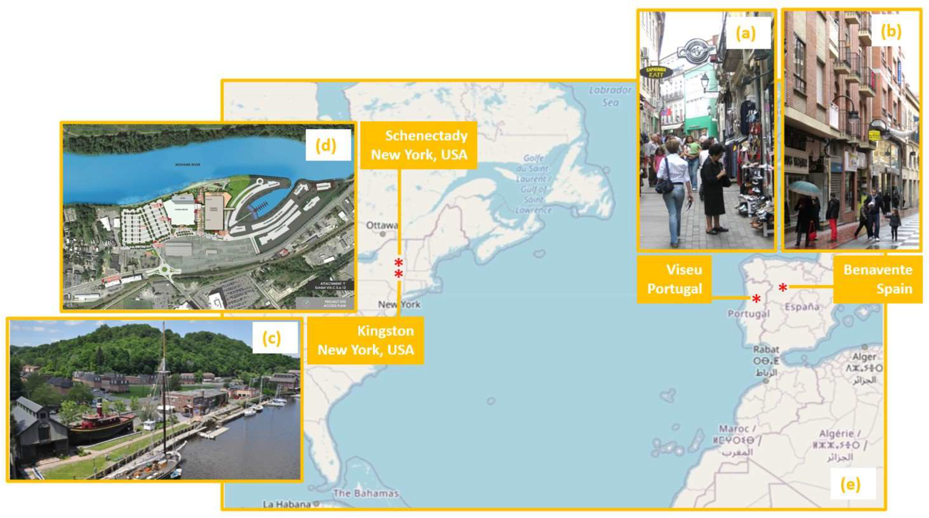
Figure 1.
Examples of city center and riverfront revitalizations on the Iberian Peninsula and in the Northeast of the United States: (a) Viseu’s Rua Direita; (b) Benavente’s Calle de los Herreros (images courtesy of author); (c) Kingston’s Roundout Waterfront District (image courtesy of [33]); (d) Schenectady’s casino, hotel, and marina (image courtesy of [34]); (e) Atlantic Ocean (image not to scale courtesy of [35]).

Figure 4.
Kingston’s Waterfront Development Implementation Plan (image courtesy of [62]).
Figure 4.
Kingston’s Waterfront Development Implementation Plan (image courtesy of [62]).

Figure 5.
Schenectady’s riverine land uses and new casino, marina, and hotel complex (image courtesy of [96]).
Figure 5.
Schenectady’s riverine land uses and new casino, marina, and hotel complex (image courtesy of [96]).


Table 1.
Synthesis of the northern Iberian Peninsula cases.
| CRV Theory Precepts | Portuguese Exemplar—Viseu | Spanish Exemplar—Benavente |
|---|---|---|
| Population (2021) | 99,551 (municipality), 25,800 (city) | 17,523 |
| Location of the main streets/squares | Historic center, Rua Direita (oldest and longest street in the medieval city), Rua Formosa concentrates retail, restaurants, and bars. | Calle de los Herreros and Calle de la Rúa are the longest and most commercial streets in the city center. |
| Proportion of the pedestrian precinct | Rua Direita (Cardo Maximus) links Largo Mouzinho de Albuquerque to Rua Formosa. | The precinct covers most of the city center, with ceramic tile pavement. |
| Relationship between the streets and the surrounding areas/activities | Decrease in the number of retail establishments during the 2000s | Retail on the ground floor with housing and services above |
| Accessibility to the pedestrian precincts and movement in the street | Restricted mobility and accessibility for deliveries 20:00–10:00. | Open circulation 7:00–11:00 Monday–Saturday, restricted access afterwards (retractable bollards), parking available at Plaza Mayor and Plaza del Grano |
| Conciliation between the needs of different street users | Surface parking lots, mini-buses, tramway (funicular) | Mixed tile pavement, designed sidewalks and travel lane |
| Strategies to respond to competition from new and emerging centers | Pedestrian street, replacement of infrastructure, renovation of the built environment, maintenance of key cultural and public institutions, digital shopping platform, fidelity card, integrated urban revitalization plan | Retail offer in the city center, cultural festivals |
| Funding of improvements and continued management and promotional activities | Commercial urbanism interventions with adhesion rates of around 30% and 5% | Commercial modernization managed by Chamber of Commerce, Industry and Services of Zamora |
| Perpetuation of success and avoidance of decline | Technical support office, municipal enterprise, urban rehabilitation society, historic district association | Public market forced to close, localized retail offer |
Table 2.
Synthesis of the Northeastern US cases.
| Characteristics | Hudson River Exemplar—Kingston | Mohawk River Exemplar—Schenectady |
|---|---|---|
| Population (2020) | 24,069 | 67,047 |
| Riverfront model | Historic preservation | Waterfront redevelopment |
| Example of land resources | Urban fabric, warehouses, open space, and businesses | Stockade district, community college, small park, and land parcels |
| Selected public policy instruments | Local Waterfront Revitalization Plan, Waterfront Dev. Implementation Plan, design and zoning code | Comprehensive Plan Mohawk River Waterfront Revitalization County Plan |
| Status | An attractive, culturally vibrant district; conversion of industrial sites | Recently constructed hotel, casino, and riverine marina featuring retail space, offices, apartments, and waterfront condos |
Disclaimer/Publisher’s Note: The statements, opinions and data contained in all publications are solely those of the individual author(s) and contributor(s) and not of MDPI and/or the editor(s). MDPI and/or the editor(s) disclaim responsibility for any injury to people or property resulting from any ideas, methods, instructions or products referred to in the content. |
© 2024 by the author. Licensee MDPI, Basel, Switzerland. This article is an open access article distributed under the terms and conditions of the Creative Commons Attribution (CC BY) license (https://creativecommons.org/licenses/by/4.0/).
Share and Cite
MDPI and ACS Style
Balsas, C.J.L. Urban Revitalization in Small Cities across the Atlantic Ocean. Sustainability 2024, 16, 639. https://doi.org/10.3390/su16020639
AMA Style
Balsas CJL. Urban Revitalization in Small Cities across the Atlantic Ocean. Sustainability. 2024; 16(2):639. https://doi.org/10.3390/su16020639
Chicago/Turabian StyleBalsas, Carlos J. L. 2024. "Urban Revitalization in Small Cities across the Atlantic Ocean" Sustainability 16, no. 2: 639. https://doi.org/10.3390/su16020639
Note that from the first issue of 2016, this journal uses article numbers instead of page numbers. See further details here.