Article

Assessing Rural-Urban Linkages and Their Contribution to Territorial Development: Insights from Zimbabwe’s Small and Medium-Sized Cities

1
CIRAD, UMR ART-DEV, University of Montpellier, 34398 Montpellier, France
2
UMR ART-DEV, University of Montpellier, 34090 Montpellier, France
*
Author to whom correspondence should be addressed.
Sustainability 2023, 15(7), 6223; https://doi.org/10.3390/su15076223
Submission received: 28 September 2022 / Revised: 13 March 2023 / Accepted: 17 March 2023 / Published: 4 April 2023
(This article belongs to the Special Issue Territorial Approaches to Sustainability)

Abstract

:
In Sub-Saharan Africa, unprecedented population growth, concomitant with limited industrialisation and job creation, have changed the configurations of rural-urban linkages in recent decades. Indeed, as primate cities do not act as strong engines of growth, territorial dynamics are rapidly being reshaped by renewed flows of people, goods, services and information within and between economic sectors, and between rural and urban areas. Rural densification and the fast expansion of small and medium-sized cities is one manifestation of these changes. As a result of silo thinking about rural and urban in most national strategies, plus the widespread informal economy and limited available statistics in the region, these new rural-urban linkages and their contribution to socioeconomic dynamics remain underexplored. Contributing to fill this gap, the aim of this paper is to present and test a method to assess rural-urban linkages and their possible role in territorial development in southern countries. We use a holistic approach and adopt an original posture, taking rural areas as the point of reference. Our method sets proxy indicators for specific information that is missing on rural-urban linkages. These indicators are then used to build a typology of territories according to potential rural-urban linkages, using a multivariate analysis and clustering. When applied to the case of Zimbabwe, the results reveal three types of districts, which differ in terms of the nature, intensity, direction and potential of rural-urban linkages for territorial development. We discuss the method’s suitability in a diagnostic phase and how it could feed strategic thinking to mainstream rural-urban linkages in territorial development actions.

1. Introduction

The demo-economic transition in Sub-Saharan African countries, concomitant with globalisation, is unique. It is characterised by limited industrialisation and unprecedented population growth [1], with increasing rural population densities and rapid urbanisation. Urban centres of less than 300,000 inhabitants account for 60% of urban growth in the region [2] and human mobility and capital flows between rural and urban areas have intensified [3]. Given these structural characteristics, the historical role of rural-urban labour migration in SSA differs from that encountered in the demo-economic transitions in other countries or regions of the world [4]. Thus, although definitive rural-urban migration still prevails in many countries, it contributes less and less to urban population growth [5] and coexists with diverse migration patterns. Furthermore, the links between the countryside and cities do not just concern the usual transfer of labour from rural to urban areas. These links are increasingly dense, largely as a result of the circular migration of rural people. This calls into question the classic reading of the demo-economic transition [6]. The content and configurations of rural-urban linkages—flows of people, goods and services, money and information between rural and urban areas—have changed. Observations reveal that these flows are multidirectional within and between economic sectors, as well as between rural and urban areas [7,8,9]. Rural-urban linkages blur the rural-urban divide [8,10,11] and their configurations vary according to territorial context [12]. A better appreciation of the role of rural-urban linkages is crucial for understanding territorial development in a specific area and the development asymmetries between different territories in Sub-Saharan African countries.
Over the past 30 years, data show that rural-urban migration has been redirected to secondary cities, especially small and medium-sized cities [2] defined either based on varying quantitative population thresholds, the position in the urban hierarchy or the cities’ functional attributes [12]. In fact, growing evidence reveals how, by modifying production, distribution and consumption processes, these cities appear to have stronger linkages with rural areas than is the case for large cities [13]. Thus, they can contribute to regional dynamics and poverty reduction through rural-urban linkages [14,15,16,17,18,19,20]. Further, small and medium cities also play a role in managing natural resources to meet the needs of growing rural and urban populations in the face of environmental change [21,22]. These trends can be explained by core drivers. First, improved communications and infrastructure increase labour migration and the overall mobility of people between rural areas, large cities, and small and medium-sized cities [23]. Second, the structural adjustment plans of the 1980s and 1990s made living conditions significantly worse in large cities and many people moved to the countryside or smaller towns as a result [24,25]. Third, the decentralisation processes, which began in the 1990s, are helping to make secondary cities more dynamic [26]. Fourth, the growing demand for food and other goods and services in small and medium cities has intensified flows, strengthening territorial food systems around these cities [21,27].
The importance of rural-urban linkages—especially those linked to small and medium cities—in terms of contemporary changes and sustainable regional development is now recognised on a global level [28,29]. However, the new spatial dynamics have only just started to appear on the radar of public policies [11]. With the emergence of sustainable development over the last 15 years, space has gradually become a critical issue in international debate. The adoption of the UN 2030 agenda and the SDG in 2015 was a critical step. Particularly, SDG 11 acknowledges the importance of linkages between urban and rural areas and calls for stronger national and regional development planning. The New Urban Agenda (NUA), adopted at Habitat III in 2016, has played an important role, by addressing SDG 11 and its targets. UN member states agreed to policies that “support integrated urban and territorial planning and development”. The UN-Habitat report [30] on the implementation of the NUA (2017) and the ensuing UN-Habitat report, “Guiding Principles for Urban-Rural Linkages” (2019), [31] build on these endeavours.
African countries played a role in this debate. During the preparation of the Post 2015 Development Agenda [32], the African Union (AU) Commission developed the 2014 Common African Position. It stresses the importance of moving beyond “siloed” thinking on cities, which is reflected in the AU Agenda 2063. The Call to Action states: “Provide opportunities for all Africans to have (…) clean, secure and well-planned environments by: (…) Ensuring balanced development of all human settlements while embracing a rural-urban continuum (…)” [33]. Yet, despite the willingness to shift the regional dialogue on urbanisation in order to focus on the interactions between rural and urban spaces, the AU’s strategic priorities remain largely sectorial. Rural and urban challenges still tend to be addressed separately [34], and planning and governance systems often fail to address the social and spatial consequences of the complex and shifting rural–urban connections [28]. Thus, their contribution to territorial development is overlooked.
One of the main difficulties is the lack of specific information about rural-urban linkages, particularly in southern countries, which do not have access to adequate data for a more integrated approach to territorial development [31,35,36]. This paper focuses on this information gap and the renewed role of rural-urban linkages in territorial dynamics and development. It contributes to the design and testing of innovative methods that seek to identify the local specificity and complexity of rural-urban linkages during the diagnostic phase of integrated territorial approaches. In this perspective, the Swiss Development Cooperation mobilised some of the results presented in this article to enhance its cooperation programme “Zambia-Zimbabwe 2023–2026”.
The specific aim of the paper is to present and discuss a method to assess rural-urban linkages, their effects on territorial dynamics with regard to small and medium-sized cities, and their potential contribution to territorial development, supporting livelihoods and economic activities. By territorial development dynamics, we refer to processes of change in terms of social and economic structures and the institutional framework of territories, and the territorial development outcomes resulting from these processes (growth, social inclusiveness and environmental sustainability). We seek to answer three interlaced questions: how can we assess the rural-urban linkages associated with different-sized cities? To what extent may rural-urban linkages generate (or remove) value in a territory, by changing the dynamics of production, distribution and consumption? Lastly, what does this tell us about entry points for action to encourage local territorial development?
To answer these questions, the rest of the paper is structured as follows: by drawing on a critical review of theoretical and methodological developments, we build a comprehensive approach to consider the multidimensional drivers of rural-urban linkages and conceptualise space as a rural-urban continuum [37], where rural-urban linkages and agglomeration dynamics shape territories [38] (Section 2). Thus, we propose a method to assess rural-urban linkages and their potential for territorial development (Section 3). This method is applied to assess rural-urban linkages in Zimbabwe revealing three different kinds of territories in terms of the type of rural-urban linkages, their intensity and their potential to generate value in the territory (Section 4). Lastly, we discuss the method used and how our findings could enhance strategic thinking in Zimbabwe (Section 5). Section 6 presents the conclusion.

2. Rural-Urban Linkages: A Review of Theory and Practice

Space, and specifically, flows of people, information, goods and services between rural and urban areas are central to the agglomeration and location theories underpinning policy debates about models of regional development (“regional” or “territorial” development are used interchangeably, according to anglophone or francophone literature). This section presents a critical review of the later and describes the conceptual position adopted in this paper.

2.1. Spatial Differentiation, Development and Rural-Urban Linkages: Theories and Concepts

The first type of spatial linkage discussed in the literature on economics and regional development concerns the impact of urban centres on rural areas. In earlier standard economics, and in the new economic geography (NEG), building linkages between rural and urban areas was a matter of policy choice. Lewis’ dual sector model (1954) [39] and successive equilibrium-based models of structural transformation [40] and agglomeration [41] suggest that there is a positive link between urbanisation, economic growth, and poverty reduction. Another core paradigm is that of functional regional development, whereby regional development is considered as a function of national development and can be expressed in terms of two strategies: growth centre strategies and rural service centre strategies [42]. The growth centre strategy is derived from Perroux’s growth pole theory. It advocates urban industrial expansion in a few growth centres with a view to generating spread effects to modernise rural areas. The rural service centre strategy focuses on developing small centres and their hinterland. The development of market and service centres helps increase the productive capacity of producers. Thus, it promotes agricultural specialisation and commercialisation within a national economic growth framework. These centres have an impact on agricultural production (via local markets, product collection; inputs & services), which may generate rural and regional development. In these models, generally, the high end of the urban hierarchy receives the most support. Thus, these models are controversial because they have increased the urban bias [43] in economic development policies.
Historical-structuralist approaches have described the inherent inequalities caused by urbanisation, as global capital is concentrated in cities and industrial sectors at the expense of rural society. This creates lasting spatial, social and economic differentiation, both nationally and internationally [44,45]. In developing countries, the development effects often appear to be limited in smaller centres and rural areas because growth centres have economic links with extra regional and overseas actors. Furthermore, the models advocating the polarisation of populations and capital accumulation in metro cities require high public spending, efficient and accessible infrastructure, a political purpose to achieve a territorial balance, high energy spending and control over externalities [46].
The second type of linkage is considered in terms of the impact that rural areas have on urban centres and non-agricultural activities. The literature on regional development recognises that the functions of small centres depend on developments in the hinterland. However, it is the literature on rural growth linkage that reflects this linkage in terms of specific consumption and production linkages [47]. Given the rural void in the literature and the potential for economic development in rural areas, researchers also explored the benefits and limitations of rural–urban linkages with regard to rural areas [48,49].
Rondinelli [50] argues that both opposed visions about the type of linkages to consider led to policies that misrepresent the relationship between urban growth and agricultural development and largely overlook the mutually beneficial linkage between the two. Thus, preliminary models emerged that propose a mutually reinforcing pattern of linkages between the town and the hinterland [27].
Since the late 1980s, geographers and political economists have proposed alternative concepts of the role of space and place in development, by presenting space as a social construct. In regional and national economies, rural and urban are “opposites no more” [51]. This comes with the concept of “rural urban continuum” [52] and the idea that rural-urban interactions “are not only symptoms of the ‘development process’ but are themselves active features in the transformation of rural and urban places” [53]. Rondinelli’s approach (1988) (‘Urban Functions in Rural Development’, UFRD) [50] can be seen as an attempt to link rural and urban areas within integrated spatial development strategies. However, aligned with the same tradition as Christaller’s classic central-place theory [54], the UFRD approach failed to consider the varying characteristics of urban and rural areas. Douglass’ (1998) innovative work on regional networks [55] pointed to the need for a spatially balanced growth strategy. He replaced the mostly mechanistic view of rural and urban with a more nuanced view of rural–urban interactions.
Drawing on Anglo-Saxon and French approaches [56,57,58], the “Proximity Dynamics” works [59,60] identify institutional, organisational and geographical proximity and argue that a major determining factor of the attractiveness and competitive position of a local production space is its capacity to generate specific resources [61]. This depends on whether the local space is autonomous or dependent on the dominant economic rationale, i.e., how much it relies on connections with other spaces. In a similar vein, work that re-examines the “economic base theory” [62,63] suggests that local development is driven by spatial interactions between the economic bases of near regions, rather than between a region’s base and the domestic economy. In the African context, research also points to the role of cooperation between regions, highlighting that cities are open, externally oriented systems whose survival depends on external trade [64]. However, wealth depends on the local production of goods and services. Cities must add value to natural resources and products made elsewhere, not simply exchange and distribute them. The more efficient, resourceful and innovative city enterprises are, the more wealth and jobs will be created. These approaches bring a recurrent question to the fore: whether or not the observed territorial development is linked to the metropolitan areas or to endogenous and ascendant dynamics in non-metropolitan areas, particularly dynamics pertaining to different types of economy of proximity [65].

2.2. Critical Review of Conceptual Approaches and Tools Used to Assess Rural-Urban Linkages

There are different ways to define and measure linkages, flows and interactions between rural and urban areas, which depend on theoretical orientation and research goals. Drawing on Rondinelli’s (1985) initial classification of linkages in spatial development [66], Unwin presents an improved frame of urban-rural relations [67]. He suggests that there are economic, social, political and ideological linkages between urban and rural sites. They can be expressed physically as measurable flows of people, money and budgetary allocation. While these flows are associated with interactions between people, places and objects, they do not actually embody these interactions. Thus, labour flows are needed for an interaction between labour and capital, but they do not actually embody that labour-capital interaction..Other authors have listed various flows and linkages, leading to a broad classification in which urban-rural interactions correspond to the two-way flows of people, goods, money, technology, information and ideas [12]. Berdegue and Proctor (2015) extended the definition to the mutual flows of people, goods, services, money and environmental services between rural and urban locations [12].
The following review of empirical literature shows that successive methods and tools have been developed to assess rural-urban linkages, based on contrasting conceptual frameworks with regard to: the factors driving rural-urban linkages, their interactions, the geographical and temporal scales of analysis, and the initial rural or urban standpoint used to identify linkages.
An important preliminary approach to assessing rural-urban linkages involves regionally disaggregated analysis and economic modelling. Conceptually grounded in the rural-urban dichotomy, the aim is to measure selected economic flows and linkages at provincial and national levels (e.g., [68]). Most of the economic models that the rural-urban framework is based on are static, simplistic, and fail to account for socio-spatial realities, such as ecological conditions and growth potential in various locations [7] or different-sized urban centres. There are exceptions, for example, works that develop a Social Accounting Matrix (SAM) and economy-wide models for African countries, which differentiate between metropolitan cities, smaller cities and towns, and rural areas [69,70]. They show that structural differences, combined with strong and complex production and consumption linkages between urban and rural areas, determine the national benefits and trade-offs resulting from urbanisation and the implications of adopting urban or rural-oriented strategies. However, it is also important to consider historical, social, and cultural settings, as well as the institutions that govern space [71]. Combining aggregate modelling with information systems that capture local knowledge is a challenge. Sector-specific and domain-oriented economic research should work together to examine the opportunities offered by rural-urban linkages [7,27].
To overcome the rural-urban dichotomy, the “urban-rural gradient” or “rural-urban continuum” approach (cf. 2.1) was developed [37]. In practice, it envisages a continuous transition from urban to rural extremes, which is primarily indicated by land use and population density. The concept of the “urban-rural gradient” is still widely used as a spatial typology to contextualise data analysis in economic research [72]. Urban accessibility is featured in multiple classifications, as a measure of the travel costs of gaining access to urban services and job opportunities [35]. Hopkins and Copus describe typologies by identifying the strength of the economic linkages between small towns and the rural areas nearby [73].
The “rural-urban continuum” is associated with the greater integration of an urban area and its hinterlands. The notion has led to the mapping of Functional Economic Areas (FEAs), a second core conceptual and methodological frame to inform rural-urban linkages in empirical analyses. Here the geographical scale of linkages matters. A general type of linkage is formed by flows between a given urban centre and a large number of indeterminate, more or less distant rural areas throughout a country or even the world. These interactions may include environmental goods and services, the supply of “imported” food, and the provision of financial and ICT services to rural areas [74]. Conversely, in the FEA approach, linkages are based on the relations between a specific rural area and a particular urban location, developed through systematic repeated flows of goods, services, people and money. Geographic proximity is a feature of this kind of interaction. There is strong reciprocal dependency and spillover between rural and urban areas, so much so that the urban centre and the rural hinterland can become integral components of a single rural-urban “functional territory”, which often cuts across administrative boundaries [12,75]. In practice, FEAs are designed around a metropolitan area or a major city’s “area of influence”, based on commuting flows and factors such as travel time, gridded population census, satellite images or public service delivery areas. However, little is known about how smaller cities are connected to the broad urban system [35,75,76].
City region systems provide a similar prominent conceptual frame and tool. This term refers to “the area within which the connections between one or more cities and the surrounding rural land are intense and functionally (economically, socially, politically and geographically) connected. These areas are typically 80–100 km across and cover up to 10,000 km2 [77] The city-region approach shifts away from administrative boundaries and sectorial development strategies towards territorial strategies, characterized by vertical and horizontal structures of governance and sectors [78]. The core features of a city region and how it is represented are the subject of debate. There are also ongoing discussions about its relevance for the Global South and the UN-Habitat planning guidelines for Africa [78,79]. In a case study in China, Yang et al. go a step further, by looking at the dynamic quality of FEA [80]. They measure Urban-Rural Integration (URI), defined as a stage in the evolution of urban-rural relationships. URI integrates the city and the countryside into an organic whole. The authors develop a conceptual framework structured on the “Basis, Driver and Goal”—the Basis being factor flows and interaction of industries, the Driver being the information transportation network and environmental carrying capacity, and the Goal of the URI system being to coordinate the living levels and achieve urban-rural equivalence—of the URI system. Then, they set up an URI index to assess the regional differentiation and explore the spatiotemporal change at the URI level. Based on data from national surveys, the index could reveal the strengths and weaknesses of the URI system and play a role in system diagnosis and policy guidance.
An approach similar to FEA attempts to articulate mechanistic and more nuanced views of rural-urban linkages and their drivers: Escobal et al. (2015) draw on NEG and economic sociology and identify two categories of factors, which determine how territorial relationships develop and how this affects spatial differentiation [81]. The first are “hard/tangible factors”, such as: geographical endowments, which determine comparative or absolute advantages; the existence of linkages (backward and forward) that cause the agglomeration of activities [82]; urban biases in government policies pertaining to taxing, pricing, and investment/spending [68]. The second category includes “intangible/soft” factors, typically socioeconomic networks, social capital and governance. Their limited conceptual and practical application has been the subject of debate. However, if combined with “hard” factors, they could improve our understanding of processes that lead to successful linkages with dynamic markets in rural territories [68,83].
Both FEA and the “rural-urban continuum” have been influential as operational frames to capture rural-urban linkages. However, their use has been limited in developing countries. This is mainly due to their data requirements and because they often focus on a specific position—an agglomeration or a remote area [35]. Some recent initiatives seek to overcome the challenge of data availability in southern countries and offer a broad perspective. The Urban–Rural Catchment Area (URCA) is a conceptual frame and tool [35], representing an urban centre’s extended area of influence. Essentially, it relaxes the need for strong social and economic interaction, which is a requirement of FEAs. The URCA is based on an urban centre’s size and where other urban centres are located. In practice, URCAs are defined by matching all the rural locations to their urban centre of reference in terms of the time it takes to reach the urban centre. Each rural location is allocated to a specific category of travel time to reach one of seven categories of different-sized urban centres. This data can be used to develop urban-rural continuum indicators. The new global spatial dataset for catchment areas makes it possible to account for rural-urban interconnections more systematically. This frame relies on available global data, but it tends to focus on physical factors (population size, distance), rather than other aspects of rural-urban linkages, e.g., ‘local’ historical, political, socio-cultural or ecological factors.
However, research on rural-urban linkages raises the need to consider the complex context-specific nature of these linkages and their potential site-specific variation [12,84]. Furthermore, other authors have elaborated on the distinction between “virtuous” and “vicious” linkages, which enhance or undermine accumulation and added value at household or territorial level [18,74,76]. In this way, the dominant methodological approach to rural-urban linkages in southern countries involves ad hoc “monographies” mapping rural-urban linkages. These focus on subnational levels and are based on mixed quantitative and qualitative methods [36,76,84,85,86]. With mapping, urbanisation and rural transformation are conceptualised and informed as intertwined mutually dependent processes. Considerable attention is often given to institutional dynamics. Qualitative methods, as participatory capacity-building techniques, are combined with quantitative tools (e.g., household surveys, value chain analyses, with diverse sampling frames). This provides more specific information and compares groups and locations. These methods often stem from research or development projects and the choice of territories depends on specific action-oriented goals. They offer an in-depth understanding of the drivers of rural-urban linkages and local socioeconomic change. These approaches also acknowledge that territorial development is built from the bottom up, as much as it is conditioned by regional or national trends [76]. They advocate the use of multi-scalar approaches to capture the inclusivity of spatial patterns and socioeconomic processes.

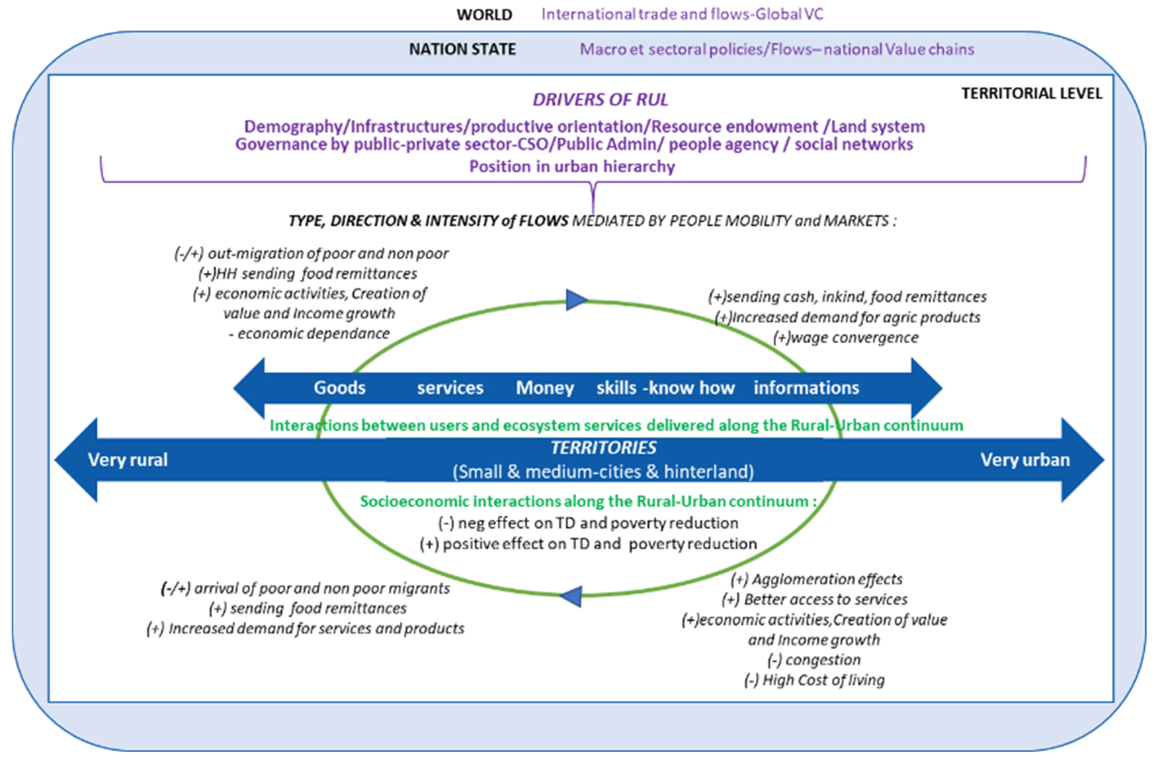
2.3. Conceptual Framework

We set out to assess the rural-urban linkages associated with diverse cities and to determine how the related flows change the dynamics of production, distribution and consumption, and generate (or remove) value in a territory, i.e., how they contribute to broad territorial development dynamics. We define a territory as a space that has a socially constructed identity and is subject to some form of authority [58,87]. This identity can be due to a combination of diverse factors, including regional history, ethnicity, culture, economic structure, biophysical conditions, infrastructure, social conflicts, and the influence of political-administrative boundaries [88].
We adopt a comprehensive approach to reveal the context-specific nature of rural-urban linkages and their outcomes. Our frame focuses on “direct” linkages between rural and urban areas that share geographic proximity [74] and acknowledges the importance of broader flows related to the national urban hierarchy. Thus, we conceptualise space as a rural-urban continuum [37], where rural-urban linkages and agglomeration dynamics craft territories, which may include an urban core or cores and which interact with peri-urban and rural hinterlands. According to the type, direction and strength of the rural-urban linkages involved in production, consumption and distribution, these relational territories generate specific socioeconomic outcomes. Woods and Helley (2016) point that research conducted from a relational perspective might start from a particular locality (a city, a town or rural district), without being constrained by it. It actually expands to follow flows and networks, which presents methodological challenges for research design and practice.
Figure 1 reviews our conceptual model to analyse rural-urban linkages and their effects on territorial development, particularly in terms of activities and incomes. As a starting point, we consider that the nature of rural-urban linkages (types, direction and intensity of flows) and their distributional effects are contingent on a set of local, national and international drivers. At the territorial level, drivers of rural-urban linkages are multidimensional. Some drivers are linked to rural and urban features, such as demography, infrastructure, productive orientation, natural resources, land system, distance and facilitators linking rural and urban areas (e.g., road and transport and telecommunication systems, energy grids, rivers). Other drivers are also known as having a strong impact on potential rural-urban linkages. These drivers may be linked to the type of governance in rural/urban areas, which may involve actors in the public sector, private sector and civil society. They also refer to people’s and households’ agency and networks.
Over and above urban and rural features, we also consider the distance to different-sized cities, given that urban hierarchy could be a significant driver of rural-urban linkages [89], particularly for access to services and jobs. Lastly, forces at national or global level (e.g., international trade, climate change) may indirectly influence the drivers of rural-urban linkages and their outcomes. Together, these drivers influence the type of flows (money, people, information, goods, services), their direction and intensity along the rural-urban continuum, through markets and migration. Ecosystem services, which allow benefits to be shared across different areas, highlight the ecological interdependence of rural and urban territories. The socioeconomic features and dynamics within the territory will reflect the positive or negative effects of rural-urban linkages on activities, incomes and broad territorial development outcomes.

3. Materials and Methods for Identifying Rural-Urban Linkages in Zimbabwe

3.1. The Choice of Zimbabwe as the Case Study

Zimbabwe is a country with longstanding and changing rural-urban linkages. These are connected to fast-growing small and medium cities and migration dynamics. They have significant potential to support territorial development [90].
In Southern African countries, patterns of urbanisation have rapidly evolved. In the last 40 years, nearly 50% of urban growth has occurred in cities of less than 100,000 people [91]. The case of Zimbabwe is no exception to the regional trends. The demographic data provide insights into the dramatic economic downturn and its impact on urbanisation and migration patterns. Figures from the last inter-censal period (2002–2012) show negative growth in the largest cities: the Harare agglomeration, Bulawayo, Mutare, Gweru and KweKwe. It is significant that during the same period, the smallest urban centres saw a rise in the percentage of inhabitants facing economic hardship. This suggests that urban livelihoods in larger centres may be less resilient than those in smaller urban centres [5]. In Zimbabwe, urban growth is clearly driven by small and medium cities: while Harare presents 1.9% of the average annual growth rate, cities with 500,000 to 1 million inhabitants and cities with less than 300,000 inhabitants showed a 1.7 and 2.4% annual increase, respectively, between 2020 and 2030 [92]. In 2020, about 3 million people lived in cities with fewer than 300,000 inhabitants and about 2.5 million lived in larger cities. By 2030, 4 million people will be living in cities with fewer than 300,000 inhabitants compared to 3 million in larger cities [92].
Dynamic migration patterns, in particular circular migration, are associated with urbanisation trends. Zimbabwe recorded the highest rate of internal migration in the world in the last inter-censal period and patterns are now less predictable, partly because the Zimbabwean economy has contracted [93]. In 2012, 23% of the population stated that they had lived in a different district 10 years earlier [94]. The spatial patterns observed in the 2002–2012 period show that migration from rural to urban areas was similar to migration from urban to rural areas (around 500,000 people). However, the dominant pattern involves migration from rural-to-rural areas (more than 600,000 people) (see Figure 2), i.e., most internal migration comes from and is directed to rural areas, thus, it fuels bottom-up urbanisation. Given that the definition of “urban” varies across countries, there is no consensus on the definition of “small and medium cities”—alternatively “small and medium sized towns” [12,63]. The Zimbabwean classification defines small and medium cities as urban centres with less than 100,000 inhabitants. Net migration by urban type during the last two inter-censal periods points to a significant decrease in Harare and large cities, with levels below 3% in 2012. This contrasts with the strong increase in net migration rates in “municipalities” and “town councils” (see Figure 3). In fact, the proportion of migrants is highest in small and medium cities, where they make up 43% of the population [94].

3.2. General Posture for Capturing Rural-Urban Linkages

The connectedness between rural areas and urban centres has usually been achieved either from the standpoint of an urban centre and its immediate rural surroundings, or from the perspective of rural locations and people. As Cattaneo (2021) did, we sought to apply a broader development approach by adopting a novel position. Our method to assess rural-urban linkages and their contribution to territorial development is grounded in the urban-rural continuum, as a dynamic multi-scalar settlement system that is produced by social and economic relationships within and between places. Our approach involved two major steps. First, we characterised the connectedness between rural areas and urban centres from the standpoint of rural areas. To account for context specificity, we used disaggregated analysis and infra-territorial data, i.e., district level, covering the whole country. We also considered the place occupied by rural areas in the urban hierarchy, including their connection with small and medium-sized cities. Assuming that the drivers of rural-urban linkages are the most suitable proxies for setting the type, direction and strength of rural-urban linkages (see Section 2.3), we can assess the multidimensional nature of rural-urban linkages. According to data collection, a factorial analysis enables us to identify the main features that differentiate the districts [95]. Second, we set out to build a typology of rural districts, based on variables that serve as proxies for the type, direction and intensity of the rural-urban linkages operating from each rural district. This provides a national overview of the diversity of rural-urban linkages in a country and of territorial imbalances.

3.3. Applying the Method in Zimbabwe

In Zimbabwe, there is little or no specific data on flows of people, money, information, goods and services between rural and urban areas at subnational level. The situation is similar in many sub-Saharan countries. Based on the premise that rural-urban linkages depend on the multidimensional features of rural areas and their relation to cities of different sizes, we established proxy indicators for the rural-urban flows, using available information at the district level, and building a corresponding typology of districts.
The first step in our method was to convert territorial features into different indicators, for which information was available at the rural district level in Zimbabwe. Then, by drawing on various scattered sources, mainly secondary data (population census reports, reports on the production and marketing of agricultural products, official websites, etc.), we filled in the indicators, which were identified to provide information about the drivers of rural-urban linkages for each of the 60 rural districts in our study (see Appendix A and Appendix B for source and data presentation). Given the diversity of the selected variables (qualitative, quantitative), we applied a Factor Analysis for Mixed Data (FAMD).
This method is useful because it offers information about the differences between districts’ features, allowing us to select variables with higher levels of contribution. Once the differences between the table of observations and the theoretical table of total independence are established, the method’s matrix formulae distribute the differences between two districts for a given modality, relative to the total of districts. The inertia, which is close to the variance, is thus assigned by successive steps on the basis of their complementarity and overlap. Given that the axes describe a decreasing dispersion of variables, the first two are the most relevant to the heterogeneity between districts (Table 1).
From there, we selected active variables for each axis, using the rule of eigenvalue > 1 per axis (only the first four axes). The distribution accounts for 14 active variables (Table 2). See Appendix C for the correlation circle for quantitative and qualitative variables.
On the basis of the FAMD results, the second step was to perform a Hierarchical Clustering on Principal Components (HCPC) in order to group rural districts into homogeneous groups. The method builds on the assumption that proximity matters for rural-urban linkages. In other words, most rural-urban linkages for a given rural district are determined by flows between the district and nearby urban centres. This is covered by the first axis of FAMD, which deals with what the population can do regarding infrastructure and structure of activity. However, other flows related to more distant urban centres are also considered in relation to population and mobility (second axis).
With the HCPC method, the distribution of districts involves a comparison of their similarities and differences in relation to the variables introduced by considering successive combinations of districts. This makes it possible to set the relevant number of clusters. This method avoids postulating with regard to any initial functional relationship between the elementary variables and the socioeconomic district outcome. As a result, district outcome is perceived as a continuum. The HCPC ultimately established three relevant clusters, each of which associates a profile of urban-rural linkages with a given level of district characteristics. Within each cluster, the HCPC also indicates the characteristics of both axes, whose variables are most likely to enter into a development process (see Appendix D: the factor map of districts based on FAMD results, and the individual profiles of districts under the influence of active variables).
In addition to variables used as proxies of drivers of rural-urban linkages, we also characterise each district type with variables, such as poverty prevalence, Gini index, Food Insecurity and corruption index. This provides a general indication of the outcomes of rural-urban linkages in terms of the socioeconomic levels in each district and allows for comparison.
The typology and results have some limitations, which should not be overlooked. The first and most important limitation is the lack of proxy information about major drivers of rural-urban linkages, which could not be considered in the analysis. For example, political governance at district level, social networks, etc., may significantly influence the dynamics of rural-urban linkages in some districts [96]. To improve the typology output, additional information focusing on local governance and the main functional linkages with small and medium cities is required (see Section 5.2). The second shortfall is that a limited selection of 14 indicators was considered to ensure a consistent statistical output [97]. Given these limitations, we have enhanced the typology by reintroducing additional variables, namely, the other 11 indicators used to characterise districts.

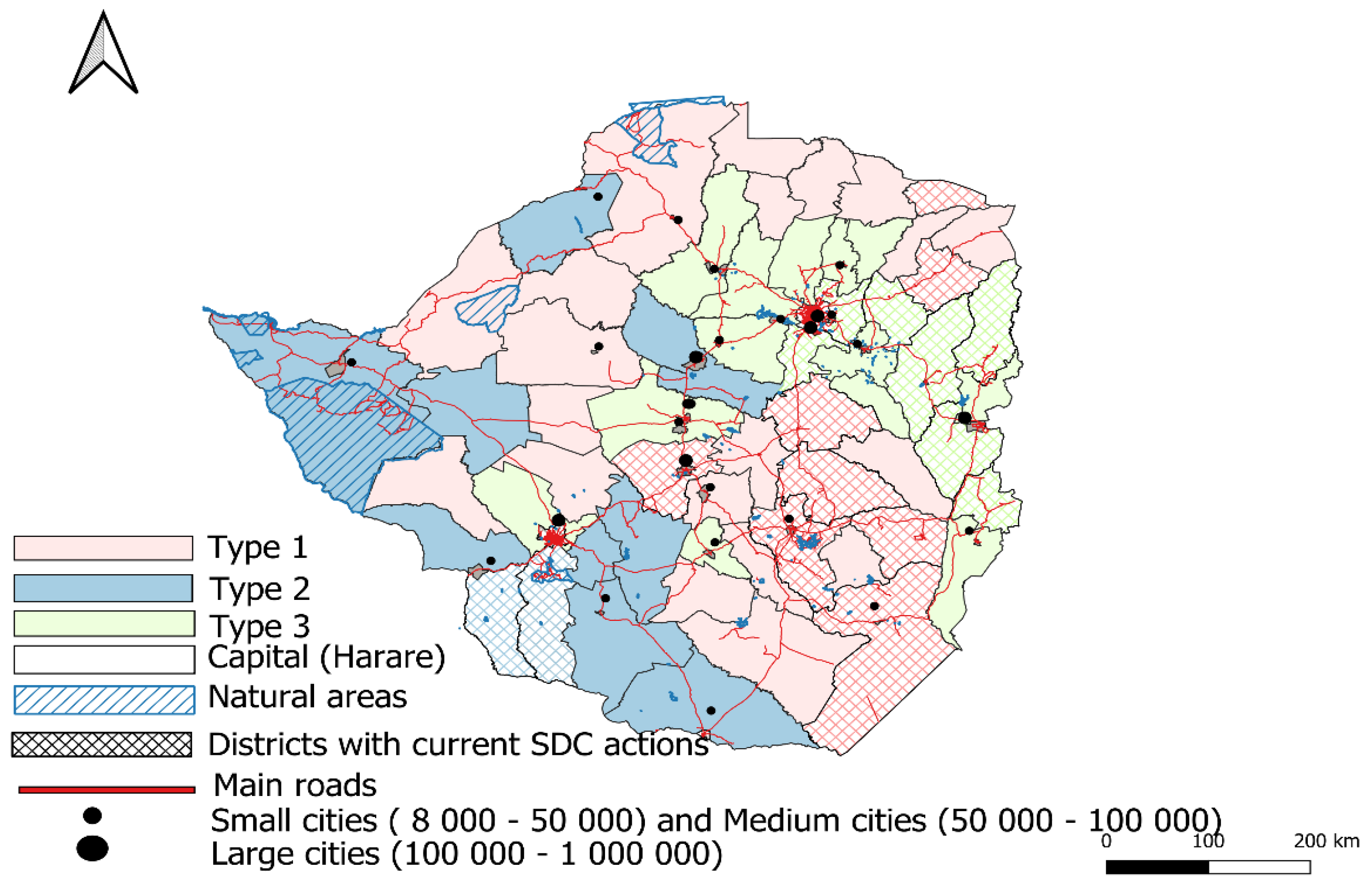
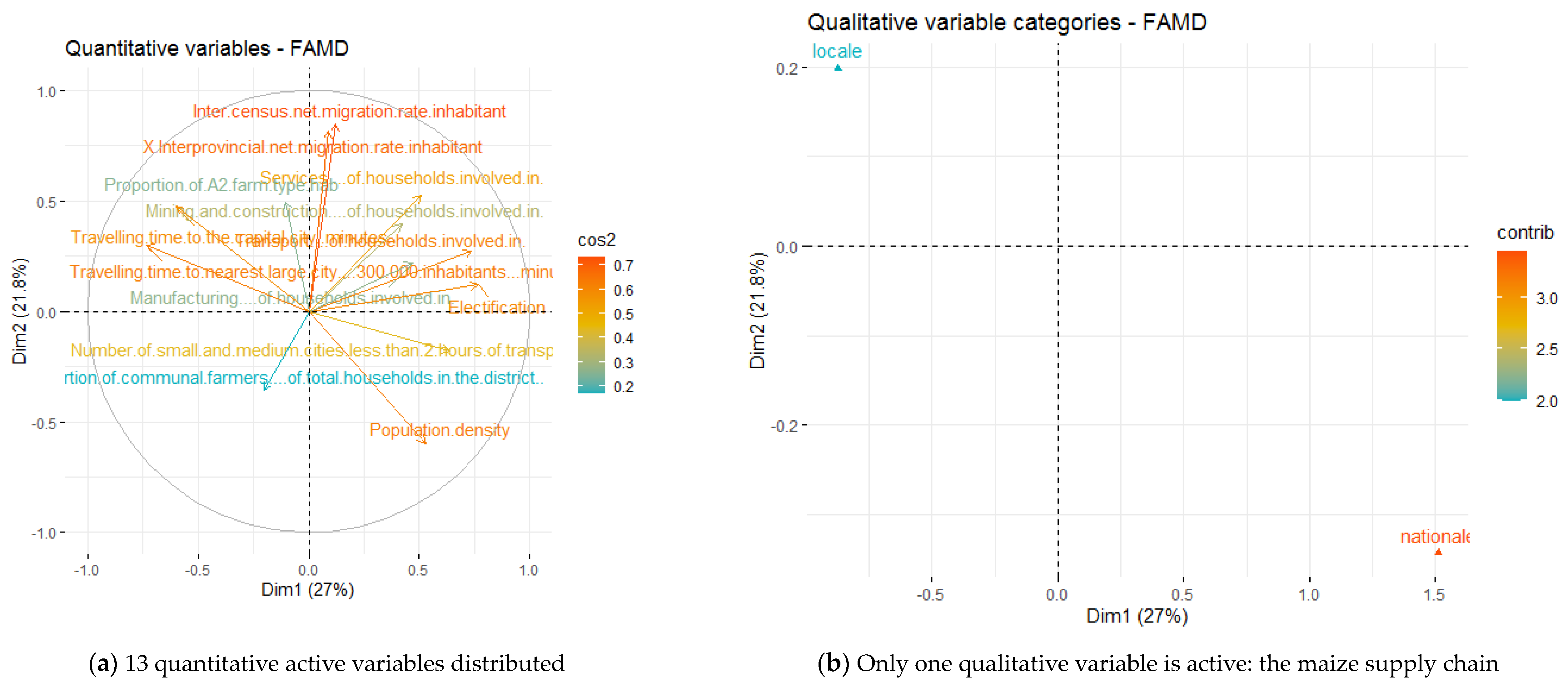
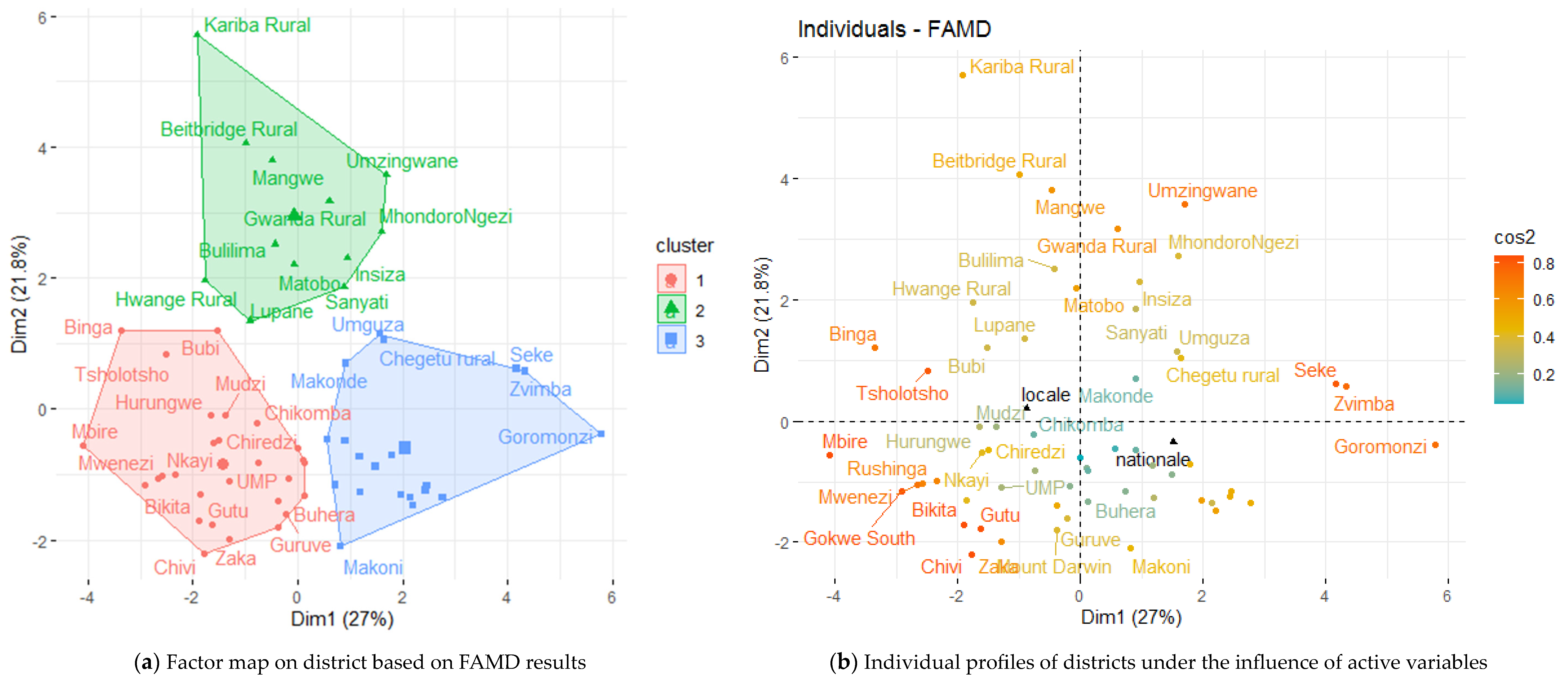
4. Results: A Typology of Rural Districts According to the Multidimensional Drivers of Rural Urban Linkages in Zimbabwe

The three contrasted types of district presented below provide stylised facts about the potential nature of rural-urban linkages and their effects on territorial development in Zimbabwe (Table 3 and Table 4).
We draw on this characterisation of district types to build three contrasted situations of rural-urban linkages. The situations vary in terms of types of flows, their direction and density and their potential to foster territorial development (Table 4). Some districts are a long way from all types of urban centres (type 2) and, therefore, are not very conducive to positive rural-urban linkages. In these districts, rural-urban linkages are usually linked to the family farming sector and their virtuous contribution to poverty reduction is limited. On the contrary, districts that are close to all types of urban centres, including small or medium cities, offer broad features (favourable or mixed) for virtuous rural-urban linkages, which are based on commercial farming, trade and services (type 3). Between the two, there are other district types, which display mixed features and are close to a few small and medium cities. Their local economies are diversified, but primary activities, as well as mining and quarrying prevail. Here, rural-urban linkages may have moderate virtuous effects (type 1). Figure 4 displays the spatial distribution of the three types of districts and potential rural-urban linkages in Zimbabwe.
The findings in Zimbabwe show how rural-urban linkages affect territories in different ways. They may optimise new market linkages, by combining more commercial agricultural production with off-farm incomes, but this depends on the dominant drivers and is not always the case. Positive linkages generally share one key factor: the added value produced through linkages may be retained and reinvested locally. Developing these flows may create more sustainable value-adding activities in strategic sectors, which will support dynamic territories. This method for assessing rural-urban linkages at a national level could be useful for strategic thinking (see Section 5.3).

5. Discussion

The aim of this research is to design and test a method to assess rural-urban linkages associated with diverse cities and their potential contribution to territorial development in southern countries—specifically Zimbabwe. Accordingly, we first discuss the relevance and limitations of our method and conceptual framework with regard to similar works. Second, we set out to explore what the results obtained in Zimbabwe (see Section 4) tell us about entry points for action or policymaking to encourage territorial development.

5.1. Relevance of the Method

Most research on rural-urban linkages has focused on high income countries and on the urban drivers and benefits, which generate more tangible or measurable outcomes (see Section 2). We set out to enrich this important field of research, by examining situations in the Global South and considering the rural end of the continuum as the entry point for setting up mutual interactions with cities.
The method allowed us to construct a national typology of rural districts as a function of the likely nature of the rural-urban linkages to diverse agglomerations, particularly small and medium-sized cities. We used two categories of variables/index: (i) variables featuring the connectedness of each rural district within the urban hierarchy (through travel time to different categories of cities); (ii) variables that characterise the drivers of rural-urban linkages from the standpoint of rural areas. We argue that this assessment method is helpful for grasping the local specificity and complexity of rural-urban linkages in the diagnostic phase of integrated territorial approaches. This is possible because we adopted three original postures.
First, we adopted a comprehensive conceptual position to consider the multidimensional drivers that determine the rural linkages along the rural-urban continuum, over and above economic features and distance. This method improves our understanding of people’s lives in rural areas in southern countries, where the majority of the population lives. It also sheds light on the opportunities provided by the linkages in these rural areas, which support bottom-up urbanisation. So far, there is scarce research that takes a rural stand to grasp rural-urban linkages, often with a limited set of drivers.
A second core aspect of our positioning helps bridge the knowledge gap regarding how small and medium cities and nearby rural locations are connected to the broader urban system [76]. We propose a framework, based on proximity to cities of different sizes, in which rural locations are featured in terms of access to services or activities provided by one or more urban centres of reference. This is very different from the URCAs approach, which was inspired by the Central Place Theory [54] and its principle of primacy regarding larger urban centres. In sum, the URCAs overlook the relationship that rural areas have with polycentric urban systems. In these territories, the population, services and employment are not concentrated in a single centre. Instead, there are two or more urban centres, which have a functional role in terms of organizing the surrounding territory [98]. The typology in Zimbabwe reveals three types of rural districts that differ with regard to their integration within the urban hierarchy. Rural districts belonging to type 3 are better connected to the national urban hierarchy because they have the highest number of nearby small and medium cities, and they are the closest to large cities and the metropolitan area. Conversely, district types 1 and 2 have some similarities. They are less well connected, relatively, within the national urban frame. Their productive orientation may play a significant role as drivers of rural-urban linkages. Type 1 districts have an agricultural-oriented base compared to type 2 districts, where economic diversification is more advanced. As a result, depending on the type of connections linking them to diverse urban centres, their rural-urban linkages may follow a different logic.
Third, unlike monographies or FEA approaches to rural-urban linkages, which usually produce a detailed analysis of one or several SMCs and their linkages to their more or less distant hinterlands (e.g., [46,76,86,99]), our frame can identify the main features of rural areas and the corresponding rural-urban linkages for the entire country. This is an advantage and makes it possible to identify the development dynamics beyond district boundaries, as well as a general country profile. For instance, type 3 rural districts, with a high density of small and medium cities and dynamic rural-urban linkages, form a circle around the capital, Harare (see Figure 3). This may result from historical urbanisation and development patterns, which were biased in favour of the capital city and the surrounding area. This dynamic may reflect a continued active path dependency. A national-scale analysis may reveal territorial imbalances and, therefore, encourage discussion about geographical and thematic issues and national public policy trade-offs—which monographies do not allow. In sum, the method could be useful for the diagnostic phase of integrated territorial development since it involves a national approach to rural-urban linkages. Simultaneously, it provides key orientations to examine the local specificity of rural-urban linkages in relation to the territories identified. The purpose is to offer an option to territorial development projects or actors that do not have well-established approaches to inform rural-urban linkages (e.g., SAM, FEA). In this respect, our approach could be part of a toolbox that provides information on rural-urban linkages to help territorial development projects or actors frame their objectives in the diagnostic stage.
We used multivariate analysis on selected variables to identify the most significant drivers of rural-urban linkages, which explain the differences between district types. A multivariate method structures and summarises data according to principal components, based on the principle of maximising variance between individuals (districts, in our case) [100]. In this way, MVA complements mapping methods (which are based on overlapping and interpreting different layers of variables). It is also more robust and precise.

5.2. Limitations and Perspectives for Reasearch

This methodological initiative presents weaknesses which could be improved with further research. First, there is tension between the chosen units of analysis. Our conceptual approach considers territories as the research unit (see Section 3.3), while our operational system uses districts as the unit of analysis—because it is the best level in terms of available disaggregated information. Therefore, the rural districts can be matched empirically with one or more specific nearby cities—but it is not possible to map the diverse multi-scalar territories that are joined to each rural district. This kind of empirical endeavour would involve a national SAM, which is challenging in terms of available data. Another alternative could be the use of national health survey to set linkages with distant urban centres. Given this limitation, our method lacks a further key indicator, namely the relationship between urban centres and territorial development dynamics. These are based on the functions that the city provides to rural locations, and vice versa. These functions can be, for instance, (i) specialised goods and services; (ii) social, economic and cultural interaction; (iii) links to infrastructure networks connecting local communities with regional, national, and international communities; and (iv) public and government administrative services for channelling local demands [101]. As a result, at this stage, the present method “only” allows us to identify the dominant types of rural-urban linkages, which can support territorial development in the district, but not in a wider territory.
A second related point is that although the method provides information about different types of rural-urban linkages (nature, intensity and direction), it tells us little about the social relations that ground the interactions or the institutions that govern them. Typically, socioeconomic networks, social capital and governance dimensions—referred to as core drivers in the conceptual framework—would improve our understanding of the processes involved in the successful linkages in rural territories. Integrating the various institutional dimensions would be helpful. This brings us back to the challenge we face in terms of the information available at district level regarding intangible drivers of rural-urban linkages. Hence, our approach should be considered as a first step to select a specific context and narrow down development actions. Complementary methods could then be adopted to provide information on local dynamics related to selected districts—typically those mobilised in monographic approaches. Thus, the methods would involve integrating a two-stage approach: (i) building a national typology of districts according to an assessment of rural-urban linkages based on our approach and in line with specific policy or development programme objectives; (ii) conducting a more in-depth analysis of targeted districts, using a monographic approach to address aspects of governance.
Lastly, unlike some initiatives (e.g., [80]), our conceptual framework remains static. It offers a snapshot of the status of rural-urban linkages in different types of districts. This typology may evolve at different rates. Consequently, its application should be limited to the preliminary diagnosis phase of the territorial approach. Place-based diagnoses can then be used as a baseline for strategic thinking in order to determine actions and build a common understanding of national and territorial issues.

5.3. Entry Points for Strategic Thinking: Rural-Urban Linkages for Territorial Development in Zimbabwe

As mentioned above, one of the contributions of this work is to identify different types of rural-urban linkages and territories on a national scale. This allows us to suggest strategic entry points for sustainable territorial development action. This section makes a series of propositions for Zimbabwe, which have been considered in the SDC regional strategy 2023–2026 to help identify areas of intervention and orient current or future actions in specific territories [88].

5.3.1. Supporting the Development of Local Food Systems

Overall, there are low levels of added value in Zimbabwe’s food economy. However, the densification of rural-urban linkages, through agricultural market linkages, represents a good opportunity for territorial development, especially in terms of job creation in downstream activities. Given the economic importance of the food economy—a term that encompasses farming, upstream activities (equipment and input provision, and extension, information, training, and maintenance services, etc.) and downstream activities (food processing, packaging, transportation, wholesaling, retailing, catering, waste management)—now and in the foreseeable future, one possible strategy to maintain and/or create added value locally could be to develop more inclusive and sustainable local food systems, based on rural-urban synergies. Besides increasing production, there are other ways to create added value in food systems. Two methods are fairly accessible, which makes them of particular interest: food processing and improving the quality of processed food products, and recycling agricultural residues (for animal feed or energy production). This fortifies ties between urban consumers and rural producers, with the expansion of specific food markets in urban areas (farmers’ and municipal markets, public procurement).
However, the options for improving rural-urban linkages in the local food system may differ depending on the structure and organisation of value chains and the level of integration into the nearest urban markets. Indeed, in Zimbabwe, the typology of rural-urban linkages suggests that some duality is likely to continue. Some rural districts may have poorly structured agricultural value chains, which are not well-integrated into dynamic urban markets. In contrast, some districts may have quite dynamic local value chains connected to a variety of urban centres. In areas with poorly structured value chains, the priority may be to improve agricultural production (regularity, quantity and quality) and market infrastructure in order to develop more efficient and diverse market channels. In rural areas and in small and medium cities, developing basic infrastructure (e.g., public marketplaces, public/private grain storage facilities), could reduce post-harvest losses. In districts with more structured value chains and basic infrastructure, additional initiatives may help improve rural-urban linkages, for example, food processing and recycling, as well a strengthening tie with urban consumers in small and medium towns.
In Zimbabwe, as in many SSA countries, the industrialisation of the food sector has been limited to a handful of corporate businesses which process export-oriented cash crops (such as cotton or tobacco) and imported agricultural commodities (milling industries or breweries, for example). The local-to-local food economy is dominated by small-scale food processing and catering activities in urban areas. This type of food processing is labour-intensive and enables many young family members to enter the labour market and contribute to household livelihoods. It is a way to sustain virtuous rural-urban linkages. However, small-scale food processing units face specific constraints because of the atomisation of food production, and access to credit and/or technology for improving product quality. In addition, there are no collective organisations to facilitate dialogue with public authorities and to help them gain recognition.
Recycling agricultural residues can limit post-harvest losses and generate added value. First, rural producers could use diverse sub-products (rice bran, groundnut leaves, soybean cakes) for animal feed to supply rural and urban markets, e.g., small-scale animal fattening in urban and peri-urban areas. Agricultural residues can also be used to produce energy for productive activities (such as small-scale food processing) in rural areas and small and medium cities. In many areas in Zimbabwe, energy is supplied by autonomous internal combustion engine-based systems, photovoltaic or thermal solar networks and, to a lesser extent, by electricity from the national grid. In the case of autonomous fossil fuel-based systems, the fuel supply is expensive and irregular due to shortages of imported petroleum products at ports, problems transporting fuel to rural areas, and final energy cost. The energy provided by photovoltaic systems is not compatible with semi-industrial or industrial activities because power output is sporadic and too low. The national electric power grid is subject to recurrent power outages because capitals and main cities are given priority. These factors limit the expansion of small and medium cities in the food-processing sector in rural areas and small and medium cities, forcing them to relocate to main cities.
Strengthening ties with urban consumers in small and medium cities is another point. Urban diets are changing, which represents an opportunity to create more added value in local or regional food systems [102]. There is a risk that changing diets will be influenced by the huge diffusion of highly processed products from international brands. The phenomenon often comes with the development of supermarkets [103]. Processed products have adverse effects on consumer health (because of their high fat and sugar content and low nutritional quality). Moreover, they do not create any added value at the local level. To counteract this trend, the use of local products with a high nutritional value should be encouraged. This could be achieved with communication to raise consumer awareness about local high-quality products and by developing quality labels. Local products could be promoted through mass public procurement for hospitals and schools (school feeding programmes) and incentives to supermarkets to reduce their dependence on long-distance supply chains.
The typology of districts based on rural-urban linkages reveals that linkages are important in the rural districts in Zimbabwe’s mining regions. This is because the remittances sent from small mining cities to rural areas can be significant and help improve rural livelihoods. However, mining is an unstable activity, which depends on international commodity markets, and market fluctuations impact rural livelihoods. Supporting urban and peri-urban agriculture could help increase the resilience of rural populations that are dependent on mining. Urban agriculture involves the production of food crops and livestock in and around urban areas. It is increasingly common in small and medium cities and plays an important role in livelihood resilience, particularly for vulnerable groups, such as women and young people [104]. Urban farmers face specific challenges, such as access to water and land. These difficulties could be alleviated with local government interventions. Urban authorities could help provide land and clean water, extension support and better access to markets for urban farm produce.

5.3.2. Improve the Impacts of Migration with Adequate Support for Migrants

This entry point aims to strengthen the rural-urban flows mediated by people migrating in order to harness more positive spill-over effects. Circular migration and multi-sited households are common. Therefore, a holistic approach is needed to reflect the fact that programmes implemented in urban areas will affect rural areas and vice versa.
Remittances can be important for households’ livelihoods, particularly for survival strategies. Households usually use remittances to cover the costs of daily requirements (food, health, education or housing). However, actions to develop collective approaches could help optimise the use of these transfers between rural and urban areas (e.g., for productive use to create jobs). When high levels of international remittances are received in a community, co-development approaches could be explored. This is the case in some districts in Zimbabwe. For example: migrants and beneficiary households could be encouraged to use part of the funds to invest in community or private production projects, with co-funding from public and/or donor subsidies; migrants’ associations could be organised; households and migrants could be taught financial skills. Existing global initiatives should be carefully examined and adapted to local contexts and institutions.
As with cash remittances, food remittance by migrants also has a role to play in urban and rural food security. However, little attention has been given to the remittance of goods, especially foodstuffs, across international boundaries and within countries. For example, in Africa “transfers of food are invisible in the sense that they run within the family and outside market channels” [9]. Given that cash and food remittances are core livelihood strategies, improving the conditions for securing cash and/or food remittances could help households. Avoiding the high cost of formal channels would be possible if services were tailored to meet the needs of the target population. Migration is not simply a matter of going from rural to urban areas. In Zimbabwe, rural to rural and urban to rural migration is increasing. These migrants generally have more capital resources than their non-migrant counterparts and are more involved in the input and output markets. Actions could support the settlement of migrants in rural districts and to encourage interactions within the host communities. Many migrants have agricultural knowledge or market links that could benefit the local population.

5.3.3. Making Mining More Profitable and Sustainable for Local Populations

This entry point aims to develop more profitable and sustainable mining activities. Mining attracts people and, thus, increases rural-urban linkages. However, we must distinguish between two types of mining activities, which imply different types of action.
The first type is industrial and located in or near cities of different sizes. Industrial mining activities attract workers and create local activity, which intensifies rural-urban linkages. However, most of the value generated by mining leaves the territory, which means that the rural-urban linkages are not so virtuous. If mining is to make a more positive contribution to local economies, public policies should work with mining companies to set up development programmes specifically for local populations. This could take the form of a joint project with the mining companies, including equitable and transparent contracts negotiated with the state.
The second type is small-scale mining, which has developed significantly in recent years. It contributes directly to local economies, but causes major environmental problems and puts workers at risk (poor working conditions). In order to develop the potential of rural-urban linkages in regions concerned by small-scale mining, miners could be taught better practices. This could reduce pollution and help preserve the local population’s health. Fair trade mineral marketing channels could be set up to guarantee better pay, more stable incomes and improved working conditions for producers.

5.3.4. Capacity Building to Develop Territorial Approaches

Last, territorial governance is a key factor for improving rural-urban linkages. Local governments need support to help them manage emerging functional territories along the rural-urban continuum more effectively. Identifying local needs and local potential can facilitate the development of more bottom-up local solutions, involving the private sector (with possible public-private partnerships) and civil society organisations. Therefore, by investing in a territorial approach, public policies can be adapted to diverse local situations. This would create an adequate environment to enhance virtuous rural-urban linkages and bridge the gap between urban and rural resources. However, local governments often lack the necessary skills and sometimes the resources to implement territorial approaches. Therefore, a first step could involve capacity-building at local authority level (e.g., district or provincial officers and authorities governing small and medium cities), with a focus on “territorial development approaches”. This could include future-based approaches, which are suitable for territorial development [105]. Post-Covid 19, food systems should be strengthened as part of a more localised territorial approach, adapted to local needs and conditions. This would increase resilience to different kinds of crises. A second step could be to help government representatives co-design a territorial development plan with local stakeholders.

6. Conclusions

Much of the literature on rural-urban linkages has focused on high-income countries and on urban drivers and benefits because they represent more tangible or measurable outcomes. This work contributes to the rising body of empirical research that seeks to examine this crucial field in the Global South. Our specific aim was to introduce and test an innovative method to assess rural-urban linkages and their role in territorial dynamics in an African country, characterised by a demographic context with strong rural densification and the expansion of small and medium-sized cities. To achieve this, we built on a comprehensive approach that conceptualises space as a rural-urban continuum, where multidimensional and multilevel drivers of rural-urban linkages and polycentric agglomeration dynamics craft territories. We also chose rural areas as the standpoint to set the interactions with cities.
Our original method draws on rural data available at district level to characterise the drivers of rural-urban linkages, which are used to produce proxies to assess the type, direction and strength of rural-urban linkages. We then propose a multivariate analysis and clustering to establish a typology of space according to flows between rural and urban areas and their potential role in territorial development. Applying our method in Zimbabwe, we identified three types of districts in terms of the dominant and context-specific rural-urban linkages, their intensity and potential to generate value.
The discussion underlines how this assessment method can help identify the local specificity and the complexity of rural-urban linkages during the diagnostic phase of integrated territorial development approaches. We reveal how small and medium cities and nearby rural locations are connected to the broader urban system. We also propose key areas for future research to improve the method, such as identifying the indicator for the functions that cities provide to rural locations or the social relations, which ground the interactions or institutions that govern rural-urban interactions. Thematic entry points are also discussed to strengthen rural-urban linkages with small and medium cities in the case of Zimbabwe. They focus on potential actions to create an enabling environment, which would allow rural-urban linkages to enhance economic development.
The present initiative and corresponding recommendations for action should contribute to a global reflexion to move away from the prevailing sectorial and siloed planning and governance systems, which still characterise most policy frames. The feasibility of this method will strongly depend on the skills and resources mobilised for territorial approaches. Therefore, priority should be given to capacity-building, which focuses on “territorial development approaches” at the local level.

Author Contributions

Conceptualization, S.M. (Sara Mercandalli), P.G., B.D. and S.M. (Sandrine Michel); methodology, S.M. (Sara Mercandalli), P.G., B.D. and S.M. (Sandrine Michel); software, B.D.; validation, S.M. (Sara Mercandalli), P.G., B.D. and S.M. (Sandrine Michel); formal analysis, S.M. (Sara Mercandalli), P.G., B.D. and S.M. (Sandrine Michel); investigation, S.M. (Sara Mercandalli), P.G., B.D. and S.M. (Sandrine Michel); resources, S.M. (Sara Mercandalli), P.G. and B.D.; data curation, B.D. and S.M. (Sandrine Michel); writing—original draft preparation, S.M. (Sara Mercandalli) and P.G.; writing—review and editing, S.M. (Sara Mercandalli) and P.G; visualization, S.M. (Sara Mercandalli), P.G. and B.D.; supervision, S.M. (Sara Mercandalli); project administration, S.M. (Sara Mercandalli); funding acquisition, S.M. (Sara Mercandalli). All authors have read and agreed to the published version of the manuscript.

Funding

This research was funded by the Swiss Development Cooperation (SDC) in Southern Africa and the French Agricultural Research Centre for International Development (Cirad).

Informed Consent Statement

Not applicable.

Data Availability Statement

The data presented in this study are available on request from the corresponding author. The data are not publicly available due to privacy restrictions.

Conflicts of Interest

The authors declare no conflict of interest.

Appendix A

Table A1. Metadata on Indicators in Zimbabwe.
Variables at District LevelDefinitions and Sources
1. Travelling time to the capital city Definition: travel time between rural district and the capital
Source: Google Maps to assess travel time.
2. Travelling time to nearest large city (>300,000 inhabitants) Definition: travel time between rural district and nearby large city (100,000–1,000,000).
Source: World Bank (2019) report that classifies Zimbabwe’s urban centres by population size (2012) and use of city population website to identify nearby large cities, as well as Google Maps to assess travel time.
3. Number of small and medium cities less than 2 h away.Definition: the number of small towns (8000–50,000) and medium towns (50,000–100,000) located less than 2 h from the rural districts.
Source: World Bank (2019) report that classifies Zimbabwe’s urban centres by population size (2012) and use of city population website to identify nearby S&M, as well as Google Maps to assess the travel time.
4. Population density (inhab/km2)Definition: population per km2
Source: Zimstat(2012), ZIMBABWE Population Census report
5. Inter-censal net migration rate/inhabitantDefinition: we use “inter-censal net migration/inhabitant” as the ratio of inter-censal net migration over total population of the rural district. The “inter-provincial net migration per inhabitant” was calculated in the same way.
Source: Zimstat(2012), ZIMBABWE Population Census report.
6. Inter-provincial net migration rate/inhabitantDefinition: the net migration rate is calculated by dividing the level of net migration (In–Out) by the population born in that province. This figure is then multiplied by 100 to produce the relative % change (positive or negative) from the original population born in the province.
Source: Zimstat (2012), ZIMBABWE Population Census report.
7. Average international remittancesDefinition: average international remittances received by households at provincial level, defined as transfers in cash between members of the same family, who are resident in different parts of the same country or in different countries. They are usually sent by a family member working in a foreign country for a year or more.
Source: ILO (2017) Population, Income, Consumption Expenditure Survey (PICES) report
8. Natural agroecological region zoningDefinition: natural agroecological region where the rural district is located
Source: Map available online: https://perspectives-cblacp.eu/natural-regions-in-zimbabwe/ (accessed on 28 September 2022)
9. Community land farmsDefinition: community land farmers as a Percentage of Employed population
Source: Zimstat (2012) Population Census Report.
10. Family farms (A1)
11. Small-scale commercial farms (A2).
Definition: we use A1 per capita and A2 per capita as the total number of farms (type A1 and A2) in the province over the population in the rural district [99].
-
A1 farms generally cover 5 hectares in the farming regions I and II, with more arable production and higher rainfall. The size increases to 10 hectares in the drier regions (III, IV and V).
-
A2 farms are small-scale commercial farms ranging from 20 to 240 hectares. Although there is much variation, the average size of new A2 farms is 318 hectares, while that of A1 family farms is 37 hectares, including crop and grazing land (according to Scoones et al. (2011) “Zimbabwe’s Land Reform A summary of findings”).
Source: information is drawn from the 2003 Report of the presidential land review committee on the implementation of the fast-track land reform programme, 2000–2002 (‘The Utete Report’).
12. Large-scale farm investmentDefinition: presence or absence of large-scale land investment in the district.
Source: The Land Matrix, official website: https://landmatrix.org/observatory/africa (accessed on 28 September 2022))
13. Type of maize value chain (national or local)Definition: refers to the nature of the maize value chain. If local production is for local markets, then the “maize value chain” is local. If local production feeds other markets from other districts/provinces, it is national.
Source: information is taken from 2015 Zimbabwe Vulnerability Assessment Committee (ZimVAC 2015) and is based on Maize Grain Source Market (inside or outside district)
14. Maize production status (Minor deficit/major deficit/surplus)The information drawn from the FEWS Network indicates the current situation in the district regarding maize production (see Production and Market Flow Maps, which provide a summary of experience-based knowledge of market networks that are significant for food security)
15. Tobacco production Definition: we use provincial data and district population to compute production/inhabitant
Source: Tobacco Industry and Marketing Board (2018) Annual report
16. Mining and construction Definition: percent household employed in mining and construction.
Source: ZimStat (2012) Population Census Report
17. Services Definition: percent household employed in services
Source: ZimStat (2012) Population Census Report
18. Transport Definition: percent household employed in transport
Source: ZimStat (2012) Population Census Report
19. ManufacturingDefinition: percent household employed in manufacturing
Source: ZimStat (2012) Population Census Report
20. Number of food markets/ districtDefinition: total number of markets in the rural district
Source: Markets covered by Zimvac (2016) Assessment and Grain Marketing Boards
21. ElectrificationDefinition: percent distribution of households in dwelling units with electricity by district.
Source: ZimStat (2012) Population Census Report
22. Number of schools above primary level Definition: number of secondary schools in the province + number of universities in the province over total population aged 15–24.
Source: Zimbabwe Ministry of Education’s official website (for secondary schools) and Google for the total number of universities in each province
23. Corruption indexDefinition: assessment of government’s fight against corruption. Respondents were asked: how well or badly would you say the current government is handling the following matters, or have you not heard enough to say: Fighting corruption in government?
Source: AFRO BAROMETRE (2015), Afrobarometer Dispatch No. 25
24. Gini indexDefinition: the Gini index is a synthetic indicator of the level of inequality for a given variable; here we use the income level and population. It varies between 0 (perfect equality) and 1 (extreme inequality). Between 0 and 1, the higher the Gini index, the greater the inequality.
Source: Zimstat (2015) Zimbabwe Poverty Atlas.
25. Food insecurityDefinition: the recurrence of food insecurity (2009–2013) was calculated in 2015. The key indicator used for the analysis was the recurrence of food insecurity among 20% or above of the population. The 20% threshold was set in order to represent 1 or more out of 5 households/people from the total district population as food insecure.
Source: World Food Programme (2015) Integrated Context Analysis (ICA)
26. Poverty prevalenceDefinition: the analysis compared the average consumption of an individual in a household to the national total consumption poverty line per capita. Then, Atlas used the Total Consumption Poverty Line (TCPL) or the upper income poverty line of US$71.08, which was compared with the per capita consumption expenditure at household level. Poverty prevalence in the Atlas was expressed as a percentage; thus, ward-level ranking was based on the percent figures and not the number of poor households.
Source: Zimstat (2015) Zimbabwe Poverty Atlas.

Appendix B

Table A2. The database structure.
Dimensions of Drivers of RULVariables at District LevelType of IndicatorDescription of the Indicator
1. Position of rural district in the urban hierarchy
Indication of intensity of rural-urban linkages between rural district and different types of urban centres
1. Travelling time to the capital city Numerical—Continuous.Minutes
2. Travelling time to nearest large city (>300,000 inhabitants) Numerical—Continuous.Minutes
3. Number of small and medium cities less than 2 h awayNumerical—Discrete Number
2. Demographic features of the rural district
Population density may be related
to pressure on local natural resources and a tendency for outmigration
4. Population density Numerical–Ratio District Inhab/km2
5. Inter-censal net migration rate/inhabitant.Numerical—Ratio Inter-censal net migration rate/district inhabitant
6. Interprovincial net migration rate/inhabitantNumerical—RatioInterprovincial net migration rate/district inhabitant
3. Average income from international migration
Indication of flows of money to district
7. Average international remittancesNumerical—ContinuousLast 12 months /$US (2012)
4. Natural resources endowment of the rural district
Indication of the district’s agricultural potential and attractiveness for household livelihoods
8. Natural agroecological region zoningCategorical (5)—OrdinalNAR I: Annual rainfall > 1000 mm relatively low temperatures
NAR II: 7< rainfall < 1050, summer rainfall only
NAR III: 500 < rainfall < 800. Relatively high temperatures and infrequent heavy rain, seasonal droughts and severe mid-season dry spells
NAR IV: 450 < rainfall < 650. Frequent seasonal droughts, severe dry spells in the rainy season
NAR V: Rainfall < 450, very erratic. Northern low veldt may have more rain, but soils are poor
5. Productive orientation of the rural district—agricultural sector
Indication on farms: type, level of investment and intensity of the agricultural value chain linked to local or national markets
9. Community land farmsNumerical—RatioCommunity land farmers share in the total households in the district
10. Family farms (A1)
See definition in Appendix A
Numerical—RatioShare of A1 farm type/inhabitant
11. Small-scale commercial farms (A2).
See definition in Appendix A
Numerical—RatioShare of A2 farm type/inhabitant
12. Large-scale farm investmentCategorical—Dichotomous Yes: if there is large-scale farm investment
No: if no large-scale farm investment
13. Type of maize value chain Categorical—Dichotomous Local: the district’s maize production is sold locally
National: district’s maize production is sold at national level
14. Maize Categorical (3)—Ordinal Major deficit
Minor deficit
Surplus
15. Tobacco production Numerical—ContinuousAmount of tobacco produced per capita (Kg/inhabitant)
6. Productive orientation of the rural district—Non-agricultural sector16. Mining and construction Numerical—Ratio% of district households involved in
17. Services Numerical—Ratio% of district households involved in
18. Transport Numerical—Ratio% of district households involved in
19. ManufacturingNumerical—Ratio% of district households involved in
7. Infrastructure
Indication of the volume of flows of
agricultural products and indication of the area’s economic potential and attractivity
20. Number of food markets/ districtNumerical—Discrete Number
21. ElectrificationNumerical—RatioShare of households in dwelling units with electricity, by district
22. Number of schools beyond primary level Numerical—DiscreteNumber of secondary and tertiary schools per inhabitant 15–24 years old
8. Quality of institutions23. Corruption indexCategorical (3)—OrdinalLow
Medium
High
9. Livelihoods indexes24. Gini indexNumerical—ContinuousNumber
25. Food insecurityCategorical (3)—OrdinalLow
Medium
High
26. Poverty prevalenceNumerical—RatioPercent of households with a consumption expenditure below the national threshold.
9. Dimensions26 variables 38 modalities

Appendix C

Figure A1. The contribution of the 14 active variables of the FAMD.
Sustainability 15 06223 g0a1

Appendix D

Figure A2. Factor map of districts based on FAMD results (1); and individual profiles of districts under the influence of active variables (2).
Sustainability 15 06223 g0a2

References

  1. Losch, B.; Fréguin-Gresh, S.; White, E.T. Structural Transformation and Rural Change Revisited: Challenges for Late Developing Countries in a Globalizing World; World Bank: Washington, DC, USA, 2012; ISBN 978-0-8213-9512-7. [Google Scholar]
  2. African Development Bank Group; OECD; UNDP (Eds.) Sustainable Cities and Structural Transformation; African Economic Outlook; OECD Publishing: Paris, France, 2016; ISBN 978-92-64-25646-0. [Google Scholar]
  3. Zoomers, A. Development at the Crossroads of Capital Flows and Migration: Leaving No One Behind? Sustainability 2018, 10, 4807. [Google Scholar] [CrossRef] [Green Version]
  4. de Brauw, A.; Mueller, V.; Lee, H.L. The Role of Rural–Urban Migration in the Structural Transformation of Sub-Saharan Africa. World Dev. 2014, 63, 33–42. [Google Scholar] [CrossRef]
  5. Potts, D. Debates about African Urbanisation, Migration and Economic Growth: What Can We Learn from Zimbabwe and Zambia?: Debates about African Urbanisation, Migration and Economic Growth. Geogr. J. 2016, 182, 251–264. [Google Scholar] [CrossRef] [Green Version]
  6. Mercandalli, S.; Losch, B.; Belebema, M.N.; Bélières, J.-F.; Bourgeois, R.; Dinbabo, M.F.; Fréguin-Gresh, S.; Mensah, S.; Nshimbi, C. Rural Migration in Sub−Saharan Africa: Patterns, Drivers and Relation to Structural Transformation; FAO: Rome, Italy, 2019. [Google Scholar]
  7. van Braun, J. Rural-Urban Linkages for Growth, Employment, and Poverty Reduction. In Proceedings of the Keynote, Plenary Session I, Addis Ababa, Ethiopia, 7 June 2007; p. 22. [Google Scholar]
  8. Tacoli, C. Changing Rural-Urban Interactions in Sub-Saharan Africa and Their Impact on Livelihoods: A Summary; International Institute for Environment and Development: London, UK, 2002; ISBN 978-1-84369-187-7. [Google Scholar]
  9. Crush, J.; Caesar, M. Food Remittances: Rural-Urban Linkages and Food Security in Africa; IIED: London, UK, 2017; p. 40. [Google Scholar]
  10. Hart, G.P.; Sitas, A. Beyond the Urban-Rural Divide: Linking Land, Labour, and Livelihoods. Transform. Crit. Perspect. South. Afr. 2004, 56, 31–38. [Google Scholar] [CrossRef]
  11. von Braun, J. Urbanization and Decentralization: The Changing Urban-Rural Linkages and Opportunities of Decentralization of Services. In Proceedings of the European Regional Science Association (ERSA), St. Petersburg, Russia, 26 August 2014; p. 11. [Google Scholar]
  12. Berdegué Julio, A.; Proctor Felicy, J. Inclusive Rural–Urban Linkages; Working Paper Series N° 123. Working Group: Development with Territorial Cohesion. Territorial Cohesion for Development Program; Rimisp: Santiago, Chile, 2014. [Google Scholar]
  13. Ferede, T.; File, B. Rural–Urban Linkages in Ethiopia. In The Oxford Handbook of the Ethiopian Economy; Cheru, F., Cramer, C., Oqubay, A., Eds.; Oxford University Press: Oxford, UK, 2019; pp. 762–784. ISBN 978-0-19-881498-6. [Google Scholar]
  14. Ingelaere, B.; Christiaensen, L.; De Weerdt, J.; Kanbur, R. Why Secondary Towns Can Be Important for Poverty Reduction—A Migrant Perspective. World Dev. 2018, 105, 273–282. [Google Scholar] [CrossRef]
  15. Diao, X.; Magalhaes, E.; Silver, J. Cities and Rural Transformation: A Spatial Analysis of Rural Livelihoods in Ghana. World Dev. 2019, 121, 141–157. [Google Scholar] [CrossRef]
  16. Agergaard, J.; Tacoli, C.; Steel, G.; Ørtenblad, S.B. Revisiting Rural–Urban Transformations and Small Town Development in Sub-Saharan Africa. Eur. J. Dev. Res. 2019, 31, 2–11. [Google Scholar] [CrossRef]
  17. Jean-Charles, E.; Hélène, M. Rural-Urban Dynamics in the East African Mountains; Racaud, S., Nakileza, B., Bart, F., Charlery de la Masselière, B., Eds.; Mkuki Na Nyota in association with French Institute of Research in Africa (IFRA): Dar es Salaam, Tanzania, 2017; ISBN 978-9987-753-98-7. [Google Scholar]
  18. Satterthwaite, D.; Tacoli, C. The Urban Part of Rural Development: The Role of Small and Intermediate Urban Centres in Rural and Regional Development and Poverty Reduction; IIED: London, UK, 2003; ISBN 978-1-84369-435-9. [Google Scholar]
  19. Rondinelli, D.A. The Potential of Secondary Cities in Facilitating Deconcentrated Urbanization in Africa. Afr. Urban Stud. 1982, 13, 9–29. [Google Scholar]
  20. Hardoy, J.E.; David, S. Small and Intermediate Urban Centres: Their Role in Regional and National Development in the Third World; International Institute for Environment and Development: London, UK, 1986. [Google Scholar]
  21. Tacoli, C.; Agergaard, J. Urbanisation, Rural Transformations and Food Systems: The Role of Small Towns; IIED: London, UK; IFAD: Rome, Italy, 2017. [Google Scholar]
  22. Gebre, T.; Gebremedhin, B. The Mutual Benefits of Promoting Rural-Urban Interdependence through Linked Ecosystem Services. Glob. Ecol. Conserv. 2019, 20, e00707. [Google Scholar] [CrossRef]
  23. Bah, M.; CissÈ, S.; Diyamett, B.; Diallo, G.; Lerise, F.; Okali, D.; Okpara, E.; Olawoye, J.; Tacoli, C. Changing Rural–Urban Linkages in Mali, Nigeria and Tanzania. Environ. Urban. 2003, 15, 13–24. [Google Scholar] [CrossRef]
  24. Ferguson, J. Expectations of Modernity: Myths and Meanings of Urban Life on the Zambian Copperbelt; Perspectives on Southern Africa; University of California Press: Berkeley, CA, USA, 1999; ISBN 978-0-520-21701-0. [Google Scholar]
  25. Potts, D. Counter-Urbanisation on the Zambian Copperbelt? Interpretations and Implications. Urban Stud. 2005, 42, 583–609. [Google Scholar] [CrossRef]
  26. von Braun, J. Rural-Urban Linkages for Growth, Employment, and Poverty Reduction; International Food Policy Research Institute: Washington, DC, USA, 2007; p. 22. [Google Scholar]
  27. Chowdhury, S.K.; Negassa, A.; Torero, M. (Eds.) Market Institutions: Enhancing the Value of Rural-Urban Links; FCND Discussion Paper 195; IFPRI: Washington, DC, USA, 2005. [Google Scholar]
  28. Agergaard, J.; Ortenbjerg, S.B. Urban Transformations and Rural-City Connections in Africa. Geogr. Tidsskr.-Dan. J. Geogr. 2017, 117, 63–67. [Google Scholar] [CrossRef] [Green Version]
  29. Jamshed, A.; Birkmann, J.; Feldmeyer, D.; Rana, I.A. A Conceptual Framework to Understand the Dynamics of Rural–Urban Linkages for Rural Flood Vulnerability. Sustainability 2020, 12, 2894. [Google Scholar] [CrossRef] [Green Version]
  30. UN-Habitat. Implementing the New Urban Agenda by Strengthening Urban–Rural Linkages; UN-Habitat: Nairobi, Kenya, 2017. [Google Scholar]
  31. UN-Habitat. Urban-Rural Linkages: Guiding Principles. Framework for Action to Advance Integrated Territorial Development; United Nations Human Settlements Programme: Nairobi, Kenya, 2019. [Google Scholar]
  32. African Union. Common Africa Position (CAP) on the Post 2015 Development Agenda; African Union Commission: Addis Ababa, Ethiopia, 2014. [Google Scholar]
  33. African Union. Agenda 2063: The Africa We Want (Popular Version); The African Union: Addis Ababa, Ethiopia, 2015. [Google Scholar]
  34. UNAS. Owning Our Urban Future: Urban-Rural Linkages for Balanced Regional Development in Africa—A Consensus Study Report; Uganda National Academy of Sciences: Kampala, Uganda, 2019. [Google Scholar]
  35. Cattaneo, A.; Adukia, A.; Brown, D.L.; Christiaensen, L.; Evans, D.K.; Haakenstad, A.; McMenomy, T.; Partridge, M.; Vaz, S.; Weiss, D.J. Economic and Social Development along the Urban–Rural Continuum: New Opportunities to Inform Policy. World Dev. 2022, 157, 105941. [Google Scholar] [CrossRef]
  36. Diyamett, B. Exploring Rural-Urban Interactions in Tanzania: A Critical Review of the Methods and Tools Used; International Institute for Environment and Development (IIED): London, UK, 2001; ISBN 978-1-84369-036-8. [Google Scholar]
  37. Pahl, R.E. The Rural-Urban Continuum. Sociol. Rural 1966, 6, 299–329. [Google Scholar] [CrossRef]
  38. Barca, F.; McCann, P.; Rodríguez-Pose, A. The Case for Regional Development Intervention: Place-Based versus Place-Neutral Approaches. J. Reg. Sci. 2012, 52, 134–152. [Google Scholar] [CrossRef]
  39. Lewis, A. Economic Development with Unlimited Supplies of Labour. Manch. Sch. Econ. Soc. Stud. 1954, 22, 139–191. [Google Scholar] [CrossRef]
  40. Timmer, C.P. A World without Agriculture: The Structural Transformation in Historical Perspective; The Henry Wendt Lecture Series; AEI Press: Washington, DC, USA, 2009; ISBN 978-0-8447-4279-3. [Google Scholar]
  41. Krugman, P.R. Development, Geography, and Economic Theory; The Ohlin Lectures; MIT Press: Cambridge, MA, USA, 1995; ISBN 978-0-262-11203-1. [Google Scholar]
  42. Hinderink, J.; Titus, M. Small Towns and Regional Development: Major Findings and Policy Implications from Comparative Research. Urban Stud. 2002, 39, 379–391. [Google Scholar] [CrossRef]
  43. Lipton, M. Why Poor People Stay Poor: Urban Bias in World Development; Harvard University Press: Cambridge, MA, USA, 1977; ISBN 978-0-674-95238-6. [Google Scholar]
  44. Harvey, D. Reshaping Economic Geography: The World Development Report 2009: Assessment: Reshaping Economic Geography. Dev. Chang. 2009, 40, 1269–1277. [Google Scholar] [CrossRef]
  45. Theodore, N.; Peck, J.; Brenner, N. Neoliberal Urbanism: Cities and the Rule of Markets. In The New Blackwell Companion to the City; Bridge, G., Watson, S., Eds.; Wiley: Hoboken, NJ, USA, 2011; pp. 15–25. ISBN 978-1-4051-8981-1. [Google Scholar]
  46. Mainet, H.; Kihonge, E. Les Villes Secondaires Dans Les Relations Villes-Campagnes En Afrique de l’Est: Rôle et Capacité d’adaptation Des Petits Entrepreneurs Urbains (Central Kenya). Territ. En Mouv. 2015. [Google Scholar] [CrossRef]
  47. Ranis, G. Rural Linkages and Choice of Technology; CABI: Egham, UK, 1990. [Google Scholar]
  48. Porter, M.E.; Ketels, C.H.; Miller, K.; Bryden, N. Competitiveness in Rural US Regions: Learning and Research Agenda; Institute for Strategy and Competitiveness; Harvard Business School: Boston, MA, USA, 2004. [Google Scholar]
  49. Jablonski, B. Rural Development through Strengthened Rural-Urban Linkages: The Case of US Local Food Systems. In Economic Development in Rural Areas: Functional and Multifunctional Approaches; Dannenberg, P., Kulke, E., Eds.; Routledge: New York, NY, USA, 2016; pp. 69–82. [Google Scholar]
  50. Rondinelli, D.A. Market Towns and Agriculture in Africa: The Role of Small Urban Centres in Economic Development. Afr. Urban Quaterly 1988, 3, 3–10. [Google Scholar]
  51. Schaeffer, P.; Loveridge, S.; Weiler, S. Urban and Rural: Opposites No More! Econ. Dev. Q. 2014, 28, 3–4. [Google Scholar] [CrossRef]
  52. Lichter, D.T.; Brown, D.L. Rural America in an Urban Society: Changing Spatial and Social Boundaries. Annu. Rev. Sociol. 2011, 37, 565–592. [Google Scholar] [CrossRef] [Green Version]
  53. Dixon, C.J. Rural-Urban Interaction in the Third World; City of London Polytechnic, Department of Geography: London, UK, 1987; ISBN 978-0-946689-01-9. [Google Scholar]
  54. Walter, C. Die Zentralen Orte in Süddeutschland; Fischer: Iéna, France, 1933. [Google Scholar]
  55. Douglass, M. A Regional Network Strategy for Reciprocal Rural-Urban Linkages: An Agenda for Policy Research with Reference to Indonesia. Third World Plan. Rev. 1998, 20, 1. [Google Scholar] [CrossRef]
  56. Scott, A.J.; Storper, M. Le Développement Régional Reconsidéré. Espac. Soc. 1992, 6, 7–38. [Google Scholar] [CrossRef]
  57. Benko, G.; Lipietz, A. La Richesses Des Régions. La Nouvelle Géographie Socio-Économique; Économie en liberté; PUF: Paris, France, 2000. [Google Scholar]
  58. Pecqueur, B. (Ed.) Dynamiques Territoriales et Mutations Économiques; Géographies en Liberté; Harmattan: Paris, France, 1996; ISBN 978-2-7384-3820-1. [Google Scholar]
  59. Gilly, J.; Wallet, F. Forms of Proximity, Local Governance and the Dynamics of Local Economic Spaces: The Case of Industrial Conversion Processes. Int. J. Urban Reg. Res. 2001, 25, 553–570. [Google Scholar] [CrossRef]
  60. Salais, R.; Storper, M. Les Mondes de Production: Enquête Sur l’identité Économique de La France; Civilisations et Sociétés; Editions de l’Ecole des Hautes Etudes en Sciences Sociales: Paris, France, 1993; ISBN 978-2-7132-1006-8. [Google Scholar]
  61. Gabriel, C. Pecqueur, Bernard Intégration Des Espaces et Quasi-Intégration Des Firmes: Vers de Nouvelles Rencontres Productives? Rev. É Conomie Rég. Urbaine 1993, 1993, 489–508. [Google Scholar]
  62. Laurent, D. La République et ses Territoires, Lau…; La République des Idées; Seuil: Paris, France, 2008. [Google Scholar]
  63. Lerousseau, J. La question de l’échelle au centre d’un réexamen de la théorie de la base économique. Rev. DEconomie Reg. Urbaine 2020, 4, 617–633. [Google Scholar] [CrossRef]
  64. McGranahan, G.; Diana Mitlin, D.; Satterthwaite, C.; Tacoli, I.T. Africa’s Urban Transition and the Role of Regional Collaboration|Environment & Urbanization; IIED: London, UK, 2009. [Google Scholar]
  65. Bouba-Olga, O.; Grossetti, M. La métropolisation, horizon indépassable de la croissance économique? Rev. OFCE 2015, 143, 117–144. [Google Scholar] [CrossRef] [Green Version]
  66. Rondinelli, D.A. Applied Methods for Regional Analysis: The Spatial Dimensions of Development Policy; Routledge: New York, NY, USA, 1985; ISBN 978-0-367-15805-7. [Google Scholar]
  67. Unwin, T. Urban-Rural Interaction In Developing Countries: A Theoretical Perspective. In The Geography of Urban-Rural Interaction in Developing Countries; Potter, R.B., Unwin, T., Eds.; Routledge: New York, NY, USA, 2017; pp. 11–32. ISBN 978-1-351-21538-1. [Google Scholar]
  68. Fan, S.; Chan-Kang, C.; Mukherjee, A. Rural and Urban Dynamics and Poverty: Evidence from China and India; FCND Discussion Papers; IFPRI: Washington, DC, USA, 2005. [Google Scholar]
  69. Dorosh, P.; Thurlow, J. Can Cities or Towns Drive African Development?: Economy-Wide Analysis for Ethiopia and Uganda; WIDER: Helsinki, Finland, 2012. [Google Scholar]
  70. Arndt, C.; Davies, R.; Thurlow, J. Urbanization, Structural Transformation, and Rural- Urban Linkages in South Africa; SA-TIED: Washington, DC, USA, 2019; p. 35. [Google Scholar]
  71. Martin, R. Putting the Economy in Its Place: Economics and Geography; The Johns Hopkins University Press: Cambridge, MA, USA, 2003. [Google Scholar]
  72. Woods, M.; Heley, J. Conceptualisation of Rural-Urban Relations and Synergies. Deliverable 1.1; ROBUST: Aberystwyth, Wales, 2017. [Google Scholar]
  73. Hopkins, J.; Copus, A. Definitions, Measurement Approaches and Typologies of Rural Areas and Small Towns: A Review; Strategic Research Programme Project. RD3.4.2: Place-Based Policy and Rural Scotland; 2018, p. 39. Available online: https://www.hutton.ac.uk/staff/andrew-copus (accessed on 5 September 2022).
  74. Tacoli, C. Poverty, Inequality and the Underestimation of Rural–Urban Linkages. Development 2007, 50, 90–95. [Google Scholar] [CrossRef]
  75. Berdegué, J.A.; Hiller, T.; Ramírez, J.M.; Satizábal, S.; Soloaga, I.; Soto, J.; Uribe, M.; Vargas, O. Delineating Functional Territories from Outer Space. Lat. Am. Econ. Rev. 2019, 28, 4. [Google Scholar] [CrossRef]
  76. Djurfeldt, A.A. Virtuous and Vicious Cycles in Rural–Urban Linkages: Cases from Zimbabwe. Afr. Rev. 2012, 4, 136–156. [Google Scholar] [CrossRef]
  77. UNHSP. Leading Change: Delivering the New Urban Agenda through Urban and Territorial Planning; UNHSP: Kuala Lumpur, Malaysia, 2018. [Google Scholar]
  78. Moisio, S.; Jonas, A.E.G. City-Regions and City-Regionalism. In Handbook on the Geographies of Regions and Territories; Edward Elgar Publishing: Cheltenham, UK, 2018; pp. 285–297. ISBN 978-1-78536-580-5. [Google Scholar]
  79. Watson, V. The Return of the City-Region in the New Urban Agenda: Is This Relevant in the Global South? Reg. Stud. 2021, 55, 19–28. [Google Scholar] [CrossRef]
  80. Yang, Y.; Bao, W.; Wang, Y.; Liu, Y. Measurement of Urban-Rural Integration Level and Its Spatial Differentiation in China in the New Century. Habitat Int. 2021, 117, 102420. [Google Scholar] [CrossRef]
  81. Escobal, J.; Favareto, A.; Aguirre, F.; Ponce, C. Linkage to Dynamic Markets and Rural Territorial Development in Latin America. World Dev. 2015, 73, 44–55. [Google Scholar] [CrossRef] [Green Version]
  82. Puga, D.; Venables, A. The Spread of Industry: Spatial Agglomeration in Economic Development. J. Jpn. Int. Econ. 1996, 10, 440–464. [Google Scholar] [CrossRef] [Green Version]
  83. Hadjimichalis, C. Non-Economic Factors in Economic Geography and in “New Regionalism”: A Sympathetic Critique. Int. J. Urban Reg. Res. 2006, 30, 690–704. [Google Scholar] [CrossRef]
  84. Lohnert, B. Migration and the Rural-Urban Transition in Sub-Saharan Africa; SLE Discussion Paper; Seminar für Ländliche Entwicklung (SLE): Berlin, Germany, 2017; ISBN 978-3-936602-90-6. [Google Scholar]
  85. Lazaro, E.; Agergaard, J.; Larsen, M.N.; Makindara, J.; Birch-Thomsen, T. Urbanisation in Rural Regions: The Emergence of Urban Centres in Tanzania. Eur. J. Dev. Res. 2019, 31, 72–94. [Google Scholar] [CrossRef]
  86. Tegegne, G.E. Rural-Urban Linkages under Different Farming Systems The Cases of Coffee and Non-Coffee Growing Regions in Ethiopia; Social Science Research Report Series; Organization for Social Science Research in Eastern and Southern Africa: Addis Ababa, Ethiopia, 2001; p. 84. [Google Scholar]
  87. Schejtman, A.; Berdegué, J.A. Rural Territorial Development; Documento de Trabajo N° 4. Programa Dinámicas Territoriales Rurales; Rimisp: Santiago, Chile; p. 73.
  88. Mercandalli, S.; Girard, P.; Dione, B. How Can Improved Rural-Urban Linkages to Small and Medium Cities Contribute to Employment, Livelihoods and Food Security? Insights for the SDC Strategy 2023–2026 in Zimbabwe and Zambia; SDC and Cirad: Montpellier, France, 2022; p. 59. [Google Scholar]
  89. Djurfeldt, A.A. Theorising Small-Town Urbanisation in Sub-Saharan Africa: A Multi-Scalar Approach. Town Plan. Rev. 2021, 92, 667–677. [Google Scholar] [CrossRef]
  90. Potts, D. Circular Migration in Zimbabwe and Contemporary Sub-Saharan Africa; Boydell & Brewer: Woodbridge, UK, 2010; ISBN 978-1-84615-916-9. [Google Scholar]
  91. Zimmer, A.; Guido, Z.; Tuholske, C.; Pakalniskis, A.; Lopus, S.; Caylor, K.; Evans, T. Dynamics of Population Growth in Secondary Cities across Southern Africa. Landsc. Ecol. 2020, 35, 2501–2516. [Google Scholar] [CrossRef]
  92. UN-DESA World Urbanization Prospects. 2018. Available online: https://population.un.org/wup/ (accessed on 5 September 2022).
  93. Crush, J.; Frayne, B. Surviving on the Move: Migration, Poverty and Development in Southern Africa; Idasa Publishing: Cape Town, South Africa, 2011; Volume 4. [Google Scholar]
  94. ZimStat. Zimbabwe Population Census 2012. Final Report; ZimStat: Harare, Zimbabwe, 2012. [Google Scholar]
  95. Pagès, J. Analyse Factorielle de Données Mixtes. Rev. Stat. Appl. 2004, 52, 93–111. [Google Scholar]
  96. Ovaska, U.; Vihinen, H.; Oostindie, H.; Farinós, J.; Hrabar, M.; Kilis, E.; Kobal, J.; Tisenkopfs, T.; Vulto, H. Network Governance Arrangements and Rural-Urban Synergy. Sustainability 2021, 13, 2952. [Google Scholar] [CrossRef]
  97. Alvarez, S.; Paas, W.; Descheemaeker, K.; Tittonnel, P.; Groot, J. Typology Construction, a Way of Dealing with Farm Diversity. General Guidelines for Humidtropics; Report for the CGIAR Research Program on Integrated Systems for the Humid Tropics. Plant Sciences Group; Wageningen University: Wageningen, The Netherlands, 2014. [Google Scholar]
  98. Cattaneo, A.; Nelson, A.; McMenomy, T. Global Mapping of Urban–Rural Catchment Areas Reveals Unequal Access to Services. Proc. Natl. Acad. Sci. USA 2021, 118, e2011990118. [Google Scholar] [CrossRef] [PubMed]
  99. Berdegué, J.A.; Carriazo, F.; Jara, B.; Modrego, F.; Soloaga, I. Cities, Territories, and Inclusive Growth: Unraveling Urban–Rural Linkages in Chile, Colombia, and Mexico. World Dev. 2015, 73, 56–71. [Google Scholar] [CrossRef] [Green Version]
  100. Escofier, B.; Pagès, J. Analyses Factorielles Simples et Multiples: Objectifs, Méthodes et Interprétation, 4th ed.; Sciences Sup; Dunod: Paris, France, 2008; ISBN 978-2-10-051932-3. [Google Scholar]
  101. Satterthwaite, D.; Tacoli, C. The Role of Small and Intermediate Urban Centres in Regional and Rural Development: Assumptions and Evidence. In The Earthscan Reader in Rural–Urban Linkages; Tacoli, C., Ed.; Routledge: New York, NY, USA, 2018; pp. 155–183. ISBN 978-1-315-80048-6. [Google Scholar]
  102. OECD. Jobs for Rural Youth: The Role of Local Food Economies; Development Centre Studies; OECD: Paris, France, 2021; ISBN 978-92-64-91717-0. [Google Scholar]
  103. Moustier, P.; Holdsworth, M.; Anh, D.T.; Seck, P.A.; Renting, H.; Caron, P.; Bricas, N. Priorities for Inclusive Urban Food System Transformations in the Global South: Food Systems Summit Brief Prepared by Research Partners of the Scientific Group for the Food Systems Summit, May 10th, 2021; Springer: Berlin/Heidelberg, Germany, 2021; 23p. [Google Scholar] [CrossRef]
  104. Smart, J.; Nel, E.; Binns, T. Economic Crisis and Food Security in Africa: Exploring the Significance of Urban Agriculture in Zambia’s Copperbelt Province. Geoforum 2015, 65, 37–45. [Google Scholar] [CrossRef]
  105. Losch, B.; Valette, E.; Bourgeois, R.; Bourgoin, J.; Sourisseau, J.M.; Mercandalli, S.; Diop, H. Guidelines for Territorial Development in Africa. A Review of Core Principles and Methods of Place-Based Approaches, a Focus on Territorial Foresight; Rural Future Program; AUDA-NEPAD: Midrand, South Africa; p. 75.
Figure 1. Rural-urban linkages to small and medium cities and their potential effects on territorial development (source: authors).
Sustainability 15 06223 g001
Figure 2. Rural to urban and urban to rural migration patterns in Zimbabwe, 1992–2002 and 2002–2012. Source: World Bank 2019.
Sustainability 15 06223 g002
Figure 3. Net migration (% of population that moved in minus % of people who left) by urban type in 1992–2002 and 2002–2012. Source: World Bank 2019.
Sustainability 15 06223 g003
Figure 4. Types of rural districts according to potential rural-urban linkages in Zimbabwe.
Sustainability 15 06223 g004
Table 1. Distribution of inertia per axis and related eigenvalues.
Axis% of Inertia (%)Cumulative Inertia %Eigenvalue by Axis
127.0527.053.79
221.7748.823.05
312.9461.761.81
49.2771.041.30
56.8077.830.95
Table 2. Identification of active variables.
1234
1Population density7.3511.700.053.70
2Number of small and medium cities less than 2 h away10.701.083.0613.68
3Travelling time to the capital city in minutes9.527.3613.540.37
4Electrification15.440.470.680.90
5Travelling time to nearest large city (300,000 inhab) in minutes14.232.960.281.97
6Mining and construction (% of households involved)4.655.080.0914.41
7Community land farmers share in district households1.094.232.3438.49
8Share of district households involved in services6.798.9617.071.44
9Share of district households involved in transport14.332.410.441.71
10Share of district households involved in manufacturing5.791.6024.2311.20
11Inter-census net migration rate0.4023.581.210.91
12Interprovincial net migration rate0.2121.8311.460.19
13Share of A2 farm type per inhabitant0.288.0023.187.47
14Type of maize value chain9.220.732.383.56
Table 3. Characterisation of clusters obtained after FAMD and clustering.
Drivers of Rural-urban LinkagesVariables Used at the District Level
(14)
Type 1
n = 28
Type 2
n = 12
Type 3
n = 20
MeanSd
Position of rural district in the urban hierarchy1. Travelling time to the capital city (minutes)264* 365* 162250119.2
2. Travelling time to nearest large city
(>300,000 inhabitants) (minutes)
* 189202* 9015988.2
3. Number of small and medium cities less than 2 h away* 1.41.4* 3.12.01.4
Demographic features of the rural district4. Population density (inhab/km2)2812.95* 412917.1
5. Inter-censal net migration rate/inhabitant* 1.7 × 10−7* 8.2 × 10−7−6.8 × 10−85.8 × 10−85.2 × 10⁻⁷
6. Interprovincial net migration rate/habitant* 3.3 × 10−7* 5 × 10−7−2.3 × 10⁻⁷−1.3 × 10−74.9 × 10−7
International migrationAverage international remittances received by household (last 12 months/US$)12471610159314351032.5
Natural resources in the rural district
Type of natural agroecological region (% of districts in a NR)
NR I: >1000 mm annual rainfall, relatively low temperatures00* 155-
NR II: 700–1050 mm. Summer rainfall only* 119* 5525-
NR III: 500–800. Relatively high temperatures and infrequent, heavy rain, seasonal droughts and severe mid-season dry spells36161525-
NR IV: 450–650 mm annual rainfall, frequent seasonal droughts and severe dry spells during the rainy season3950* 1533-
NR V: <450 mm rain with very erratic rainfall. Northern low veldt may have more rain but topography and soils are poor1425* 012-
Productive orientation of the rural district—agricultural sector7- Proportion of communal farms (% of households in the district)* 45* 3040410.15
Proportion of A1 farm type/inhabitant.0.23* 0.500.200.280.002
8- Proportion of A2 farm type/inhabitant0.17* 0.300.180.210.002
9- Large-scale farm investment (% of districts with no large-scale investments)1001007592-
10- Type of maize value chain (% of districts with local value chain)* 8975* 2063-
Maize surplus (% of districts with a major deficit in maize product)36* 67* 530-
Tobacco production (kg per inhab)20.7* 1.1* 38.722.8-
Productive orientation of the rural district—non-agricultural sector11- Mining and construction (% of households involved)* 3.9* 10.86.86.20.05
12- Services (% of households involved)* 6.2* 14.6119.50.05
13- Transport (% of households involved)* 0.71.1* 130.90.004
Manufacturing (% of households involved)* 0.81.4* 1.51.20.007
InfrastructureNumber of food markets/district8.5* 6.9* 10.48.83.1
14- Electrification (% of households)* 11.820.3* 2818.80.1
Number of secondary and tertiary schools/number of 15–24-year olds0.0130.0150.0130.0130.006
N.B: * indicates significant variables, if p-value < 0.05).
Table 4. Characterisation of the different types of districts in Zimbabwe, associated rural-urban linkages and their possible contribution to territorial development.
TYPE 1: districts where rural-urban linkages make a limited contribution
Rural district with broadly unfavourable characteristics: rather undiversified economies based on smallholder farming, weak infrastructure (little access to electricity and roads), medium-low agroecological potential (Natural region III—semi-intensive to semi-extensive farming—& IV–semi-extensive farming), low density of small and medium-sized towns (1–2) and located far from capital or large cities (3 h).
Moderate rural-urban linkages largely dependent on family farming sector:
  • Important flows mediated by household outmigration with cash/in kind remittances: urban to rural flows of money, goods and services, intermittent rural to urban food remittances
  • Limited rural-urban linkages mediated by agricultural markets:
    Role of communal smallholder areas and farmer resettlement has increased. New commodity chains or channels have emerged, linking resettled farmers and nearby small cities (e.g., Gutu, Chatsworth)
    Few rural to urban flows of staple crops to national value chains, some export crops for national consumption and export (e.g., tobacco)
    Urban to rural flows of money, inputs for small to medium-scale agriculture
    Few local upstream or downstream added-value activities, mostly cash crop production (for direct export)
Rural-urban linkages probably make a limited virtuous contribution to territorial development—some support for food security and little or no support for economic activities
TYPE 2: districts where rural-urban linkages make some contributions
Rural districts with mixed characteristics: more diversified districts specialised in mining and/or services, with some commercial farming, average access to roads and electricity, but low agroecological potential (natural regions IV and V: less than 650 mm average annual rainfall, semi-extensive farming); there is a major grain deficit, some connections with a few small and medium-sized cities (one or two), quite near to large cities (e.g., Bulawayo), but quite far from the capital (between 3.5 to 6 h travelling distance).
Limited rural-urban linkages mostly supported by mining activities and services, with some commercial agriculture
  • Some flows mediated by people who migrate to work in mining and service sectors (diverse petty trade or jobs linked to mining)
  • Large-scale platinum mining investments: not labour-intensive and benefits not retained locally
  • More small-scale artisanal mining: labour intensive, local upstream/downstream activities
  • Presence of A1-A2 farms: semi-extensive farming to supply limited local markets
  • More inflows of food and products from other urban and rural areas
Rural-urban linkages provide few virtuous contributions to territorial development
TYPE 3: districts where rural-urban linkages make a major contribution
Rural district with broadly favourable characteristics: districts with the most diversified economies, commercial agriculture (natural regions I & II with more than 750 mm average annual rainfall—much more diversified farming and intensive farming region), grain surplus, transport and services developed, good infrastructure and good accessibility to all types of urban areas, high density of small and medium cities (three or more).
Dynamic rural-urban linkages mostly mediated by markets:
  • Rely on small-, medium- and large-scale agriculture, transport sectors
  • Strong rural-urban linkages related to A1 and A2 commercial agriculture for more structured national value-chains, including supply to small and medium towns (e.g., Mvurwi)
  • Rural to urban flows of products, income, some upstream/downstream activities
  • Urban to rural flows of farm inputs and services, other goods and services
  • Weak rural-urban linkages related to export of cash crops (e.g., tobacco)
  • Some rural-urban linkages related to transport service markets (other than agriculture)
Rural-urban linkages are likely to make a virtuous contribution to territorial development
Disclaimer/Publisher’s Note: The statements, opinions and data contained in all publications are solely those of the individual author(s) and contributor(s) and not of MDPI and/or the editor(s). MDPI and/or the editor(s) disclaim responsibility for any injury to people or property resulting from any ideas, methods, instructions or products referred to in the content.

