Review

Understanding the Mechanisms of Earth Fissuring for Hazard Mitigation in Najran, Saudi Arabia

by
Mabkhoot Alsaiari
1,
Basil Onyekayahweh Nwafor
2,
Maman Hermana
2,*,
Al Marzouki Hassan H. M.
3 and
Mohammed Irfan
4
1
Empty Quarter Unit, Chemistry Department at Sharurah, Najran University, Najran P.O. Box 1988, Saudi Arabia
2
Department of Geoscience, Universiti Teknologi PETRONAS, Seri Iskandar 32610, Malaysia
3
Saudi Geological Survey, Jeddah 21514, Saudi Arabia
4
Electrical Engineering Department, College of Engineering, Najran University, Najran P.O. Box 1988, Saudi Arabia
*
Author to whom correspondence should be addressed.
Sustainability 2023, 15(7), 6006; https://doi.org/10.3390/su15076006
Submission received: 18 December 2022 / Revised: 30 January 2023 / Accepted: 15 March 2023 / Published: 30 March 2023
(This article belongs to the Topic Natural Hazards and Disaster Risks Reduction)

Abstract

:
Being a fast-growing city with a high rate of urbanization and agricultural development, the city of Najran, situated in the southwest of the Kingdom of Saudi Arabia, has witnessed a series of earth fissuring events and some other geo-environmental hazards in recent times. These fissures have posed a significant threat to inhabitants and infrastructure in the area. A few studies suggest that excessive groundwater withdrawal is responsible for fissuring activities. Because of the intensity of this geo-hazard, this article presupposes that groundwater extraction alone cannot be responsible for the magnitude of fissuring activity in the area and discusses other severe factors that could be responsible for the earth fissures. The study proposes that the cause of the problem is multifaceted and synergistic, and outlines threatening factors that can inherently trigger more fissures in the region, based on the geologic history of the area and a critical review of investigative studies conducted in the area and beyond. Predicated on the region’s structural history, some undiscovered elements that can potentially cause fissuring in the region were identified and discussed. Some of these include the pre-existence of a fault system, a crack from the bedrock ridge, the existence of paleochannels, the collapsibility of loess, the tectonic (earthquake) history of the area, and differential compaction due to heterogeneity. The use of a metaheuristic and a combined application integrating other optimization algorithms can be utilized to determine optimum hyperparameters and present their statistical importance, thereby improving accuracy and dependability in fissure prediction in Najran. Reliable models would primarily be used to monitor active fissures and identify key factors utilizing spatial information, subsidence, groundwater-related data sets, etc.

1. Introduction

Recently, earth fissures, which are deformations or cracks at the Earth’s surface that occur in regions with little or no rain, mainly caused by the immoderate withdrawal or pumping of groundwater [1,2], have become one of the disturbing environmental problems across different cities in the world. It causes damage to homes and businesses, highways, bridges, waterways, drains, powerlines, farmland, pipeline infrastructure, animals, ecosystems, biodiversity, and individual lives, as well as providing a pathway for toxins to enter groundwater. According to [2,3,4,5,6,7,8], several researchers have confirmed that groundwater is vulnerable to impurity through earth fissures, and cleaning these contaminants can be an arduous and time-consuming task. As a result, this geological risk has had a huge impact on business activities, social security, and environmental conservation, garnering more attention in recent decades [9]. The occurrence of and damage caused by earth fissures have been recorded in different places around the world, including the southeast corner of the North China Plain, the southwest of the American Basin, the North Indian River Plain, the west Asian valley, the Somaliland coast in East Africa, the Iceland region, the valley of Najran in Saudi Arabia, and so on [4,10,11,12,13,14].
Focusing on the city of Najran, the increased consumption of groundwater for crop watering in the city of Najran has induced earth rifts of varying degrees in the zones susceptible to tensile stress [2]. This unexpected occurrence of earth fissures has created fear among the farmers and private owners of the area as it might render the land useless for agricultural and other purposes. Because of its inherent geomorphologic and geologic disposition, the territory is vulnerable to a variety of geo-hazards. As a rapidly expanding city, with a high rate of urbanization and agricultural development, the earth’s fissuring and some other geo-environmental hazards have posed a significant threat to inhabitants and infrastructure in Najran [15]. Due to the obvious rapid rise of the populace and the increased use of the existing infrastructure, the Saudi government is now building facilities such as motorways and urban and agricultural fields in areas near hazard zones [15]. Increased ground fissures in Najran can obstruct the building of both surface and subsurface infrastructure, according to prior events. When buildings are built in an area where there are ground fissures, issues such as structural failure or cracking, groundwater leaks, damage to already-existing buildings, and long-term structural instability may arise, because of the activity of the ground fissure [16]. Sub-layer subsidence, post-construction ground settlement following the dissipation of porewater pressure brought on by structural loads, disturbance introduced by nearby building projects, shifts in the hydrological system and aquifer infiltration, and cyclic loading of trains are a few factors that could contribute to the destabilization of structures in fissure-prone regions. These elements might lead to the expansion of ground fissures, and in the most extreme scenarios, brand-new dangers such as rail track deformation might appear [16]. Therefore, in Najran and other fissure-prone cities, remedies must be used to guarantee the long-term stability of the ground as well as the overlying structures.
Groundwater depletion or over-pumping has been identified by scientists as the main cause of earth fissuring [1,2,17,18,19,20,21,22] because it creates significant tensions in the aquifer. To maintain an equilibrium in the aquifer volume, it adjusts itself, thereby causing compression, and pressure that could result in enormous ground subsidence, and consequent fissures. According to [17], it is believed that due to various lateral motions inside the aquifer caused by groundwater harvesting from the unlithified aquifer, ground fractures begin at deep levels underneath the surface [18]. Some researchers think that these fissures are caused by the differential deformation of confined layers in the horizontal axis, and others maintain that it is a result of the forceful gradient effects of groundwater harvesting [19,20,21]. However, further studies have proven that the impact of groundwater on fissure formation can be horizontal, vertical, and oblique [18,22]. Other factors such as soil friability, non-consolidation, and the presence of pre-existing fractures can also cause earth fissures. Several investigative studies have been conducted across the world to ascertain the causes of fissure formation. Although these studies adopted different evaluation techniques at unique geologic locations, the conclusions drawn from them are somewhat similar. Some of these studies are listed in Table 1 below, which highlights the study locations, techniques adopted, and the causes of the fissure formations in the study area.
From the reviews and ongoing discussion among scientists about fissure formation processes, it can be summarized that (a) deep dynamic tectonism controls ground fissure location, (b) the internal tectonic force of the earth’s crust leads to a collection of ground fissures, (c) stresses at the fault planes induces the formation of ground fissures, (d) groundwater overmining results in the reactivation and expansion of subsurface faults, leading to fissure formation, and (e) buried paleo geomorphology aids the collapsibility of soils and formation of fissures. The assemblage and appearance of ground fissures are thus majorly influenced by the geological environment. More crucially, the combined impacts of interior geological forces (such as crustal instability, tectonic forces within a craton, and motions at fault zones) and human-instigated stresses, such as excessive groundwater extraction, heavy engineering structures, etc., cause ground fissure propagation.
A more detailed understanding of the mechanism and causative factors of fissures would assist in designing suitable ways to mitigate the fissure hazards. This paper (1) identifies and discusses five major factors that cause ground fissures by reviewing scientific studies conducted by different researchers, (2) relates these factors to suggested causes of fissures in the city of Najran for a better understanding of its development mechanism, (3) shares insightful conclusions about other potential factors that could contribute to the development of fissures in in the city of Najran, (4) presents honest opinions about fissure occurrences in Najran, and (5) makes recommendations on potential approaches that could be taken to study, monitor, and mitigate fissuring in the city.

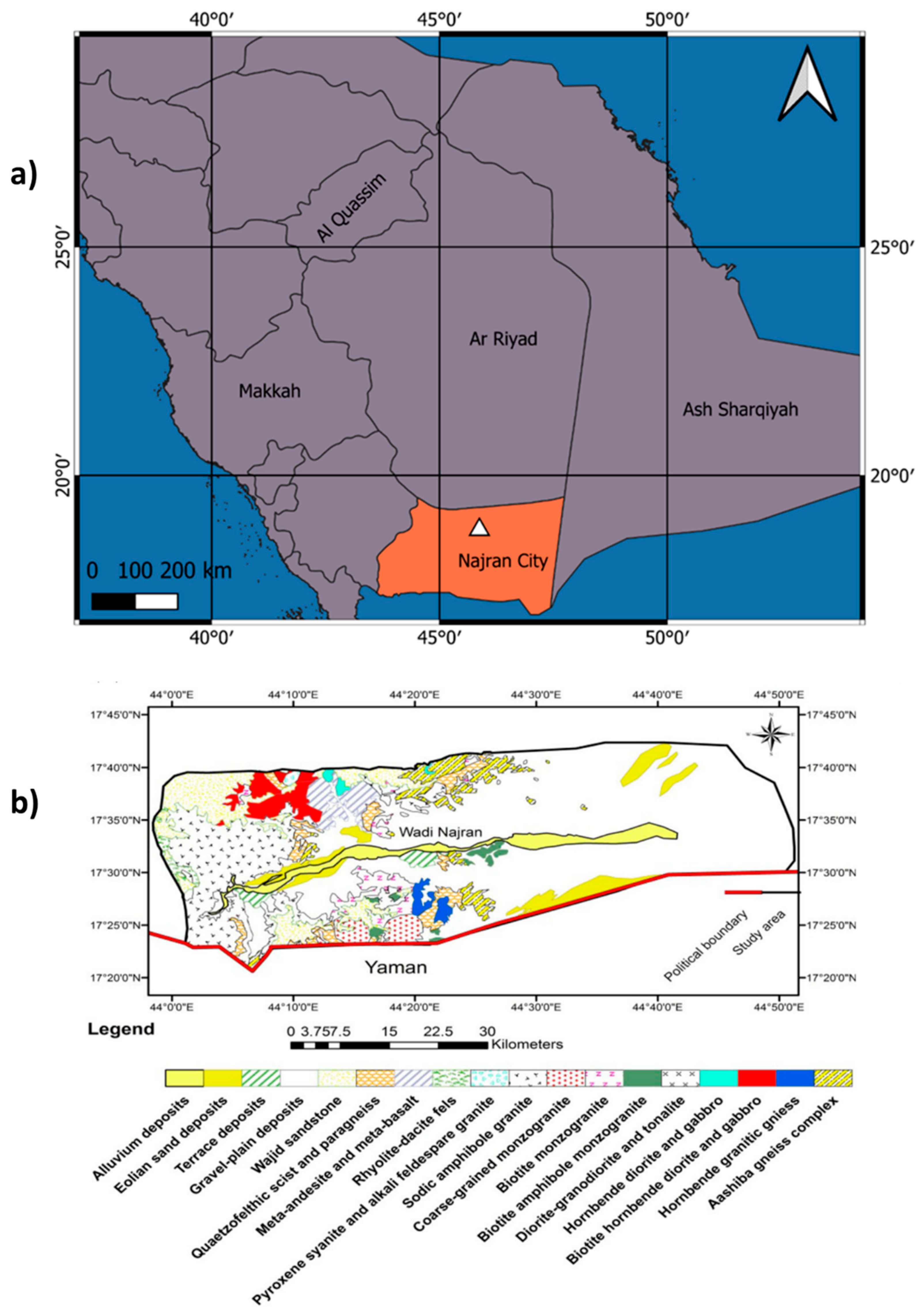
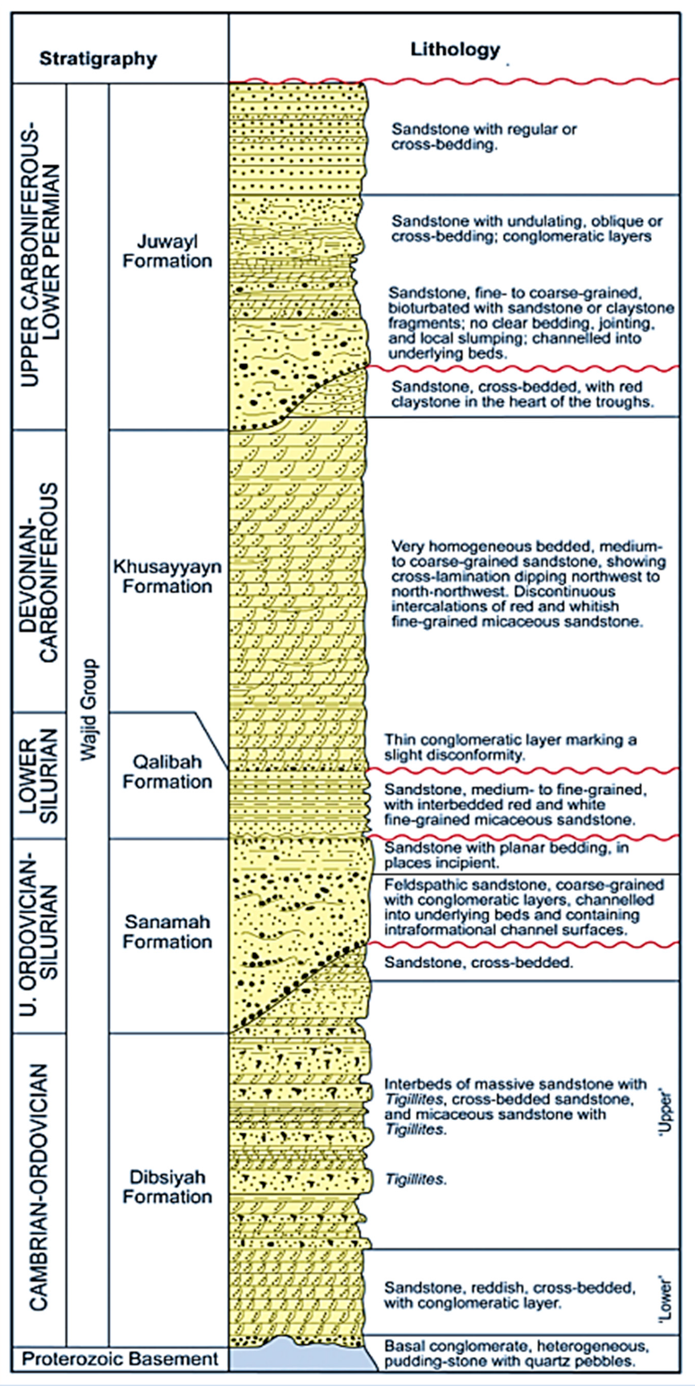
2. Geological Background

Najran is the administrative center of the Najran region in the southwest of Saudi Arabia, close to the Yemeni border (Figure 1a,b). Najran is one of the kingdom’s extremely fast-developing municipalities, with a populace that has increased nearly tenfold across an area of around 360,000 km2. In the last four decades, both the government and the private sector have invested significantly in Najran. The area is primarily an agricultural zone in Wadi Najran’s floodplain. The elevation rises to 1447 m, with elevations ranging from 883 m east to 2330 m west [2]. Three distinct geomorphic groups exist, namely (a) elevated zones in the western part, (b) lowland regions with sediments deposited across the Wadi, and (c) up the east dominated by sandy dunes. Najran is composed of volcanic Precambrian rocks, as well as Wajeed sandstone deposited during Cambrian–Ordovician age, and the later deposited tertiary bedrock [33,34]. Wadi Najran is covered in alluvial quaternary sediments, especially dunes prevailing eastward near the Empty Quarter fields atop alluvial soils.
In the study area, Wajid sandstone is found in a sequence of hill and rock formations at scattered outcrops. It lays unconformably atop the roughly flat basement rocks of the Shield of Arabia. The topmost exposure of the Wajid sandstone formations does not quite extend into the research region, but it does unconformably underlie the Permian Khuff Formation to the northeast. The Wadi Najran region is made up of Arabian–Nubian basement massif rocks such as granites, metamorphosed andesite, basalt, gneisses, granitoid formed during orogeny, and gabbro and diorite volcanic rocks. The Arabian plate’s N–S trending structures were created by extensional tectonic movements of the Arabian–Nubian Shield [35,36]. The NW–SE trending dextral fault system of Najid was created in the very last phase of its rifting tectonic system, after which the Arabian Shield was made almost plain, and the Wajid Group was accumulated during the Paleozoic in the southern region of Saudi Arabia [37]. Numerous tectonic events, mostly in the Phanerozoic, reactivated the Precambrian underlying structures [38,39,40,41]. The Wajid Group’s regional-scale fissures are most likely the result of the reactivation of those structures [42]. Sedimentary rocks cover the eastern section of the Najran region as well (Figure 1b).
The Wajid Group is a siliciclastic sequence that was deposited during the Cambrian and Permian ages and underlies the southwestern zone of Saudi Arabia [43,44]. Its exposures extend from Wadi Al-Dawasir in the south of Najran, with just a small exceptional case in some areas [44] (Figure 1b). The Wajid Group in Najran is divided into five stratigraphic units, from the earliest to the most recent formation, and they include Dibsiyah, Sanamah, Qalibah, Khusayyayn, and Juwayl [43,45], as shown in Figure 2. Based on the previous lithologic description, the lower Dibsiyah Formation is a reddish cross-stratified sandstone with some conglomerate layers deposited in some kind of fluvial channels. The topmost of Dibsiyah Formation’s intercalated massive and bioturbated sandstones were accumulated in transitional shallow marine settings. The Sanamah Formation is composed of coarse-grained conglomeratic sandstones, considered a mix of glacial and fluvial sediments. The Khusayyayn Formation is composed of river- and wind-deposited sandstone with grain sizes ranging from medium to coarse. The Juwayl Formation is massive and/or layered, consisting of grains that range from fine to coarse, deposited in a glaciofluvial setting [42,46,47,48]. The Group’s sandstones range in texture from fine to coarse, are slightly sorted, and are partly rounded to sub-angular in form. Quartz arenites that are composed of limited percentages of feldspars form the basal units; however, Khusayyayn Formation sandstone is a subarkose sandstone having a highly disproportionate amount of feldspar grains [42], as illustrated in Figure 2.

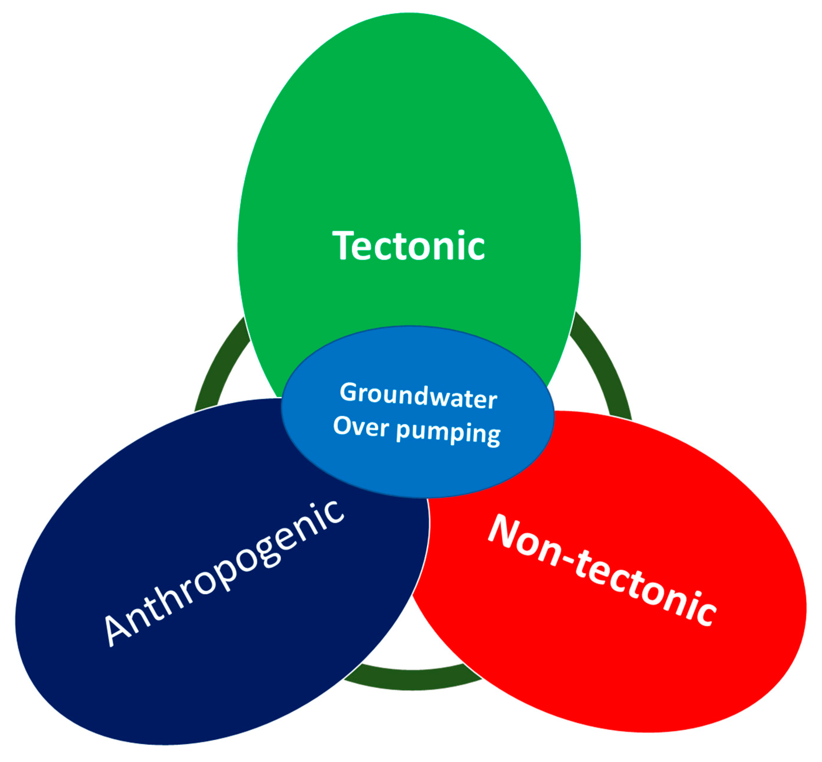
3. The Causes and Mechanisms of Fissures Formation

To better comprehend the fissuring process and establish a plan to mitigate earth fissuring and, consequently, reduce hazards, it is essential to identify the elements that influence earth fissuring. However, it is unclear how these factors affect the development and evolution of earth cracks. In the intervening decades, several theories have been put forth to elucidate how groundwater loss causes surface faulting as well as earth fissuring. Some include localized vertical differential compaction, regional variable compaction, and capillary stress related to a lowering water table [51]. It has also been proposed by [52] and [53] that aquifer displacement, particularly lateral movement, is the cause of earth fissures associated with groundwater depletion. The complicated processes of earth fissuring resulting from inordinate groundwater drawdown, as perhaps the major influential anthropogenic factor, are quite well discussed in the literature [54,55,56,57,58,59,60,61,62]. By pressurizing susceptible aquifer systems, groundwater exploitation significantly contributes to soil slope failure and fissure emergence. The subsidence associated with the extraction of liquids such as water from subterranean strata is likely the most well-studied of all anthropogenic and natural sources of subsidence [63]. In aquifer systems, lateral deformation is caused by removal and occasional recharge/discharge pressures [17,64,65,66,67]. Earth fissure is most often provincial and widespread in aquifer systems undergoing compaction, with provincial lateral stresses rarely exceeding 2 ppm and regional misalignments rarely surpassing 240 arcseconds. Linear strains can be substantial locally, especially near pumping boreholes with higher pressure gradients, along with inflections in the bedrock landforms of underground water systems, and near the borders of hydrogeologic units with differing hydraulic and (or) mechanical characteristics [63]. Enough scientific work is necessary to clarify the role of lateral strains in the formation of geological fissures in basins predisposed to aquifer system compression. Research has shown that not only horizontal deformation but shear on vertical planes and rotating stresses also play a part in the development of certain earth cracks [20]. However, scientists have argued that lateral displacement of the earth’s surface was only detected in a few spots in areas of subsidence related to groundwater depletion. They maintain that lithologic differences, such as the amount of consolidation or cementation in alluvial deposits [68], and subsurface structures such as faults, both influence the formation and placement of fissures [58], whereas the inordinate exploitation of groundwater only activates them. Based on previous studies, this paper categorizes the mechanisms of fissure formation into three, namely tectonic, non-tectonic, and anthropogenic (Table 2). Figure 3 illustrates how these mechanisms are interrelated and dependent on each other, with groundwater pumping as the central factor that triggers other processes.
The following subsections discuss these processes and how they are triggered by disequilibrium caused by groundwater over-pumping and other natural hydrological conditions.

3.1. Tectonic Mechanism

3.1.1. Crack from the Bedrock Ridge

The strata structure of the aquifer system is influenced by the bedrock ridge. The large differential settlement arises because of sediment consolidation under higher effective pressures from groundwater drawdown when groundwater is removed disproportionately for a long time. Bending can cause tensile deformation in sediments above the bedrock ridge, as shown in Figure 4. A fissure occurs when tension surpasses the tensile strain limit of soils. The elastic deformation of sediments under plane strain circumstances can be calculated using Equations (1)–(3), as the fissure develops longitudinally along the bedrock ridge.
Ex = dv/dy; Ey = du/dx;
E x = d v d y
E y = d u d x
Ƿ x y = d v d x + d v d x
where u = lateral displacement (m), v = vertical displacement (m), Ex = perpendicular strain in the horizontal direction, Ey = perpendicular strain in the vertical direction, and Ƿxy = shear deformation (strain)
For illustration, [30] studied land subsidence and the accompanying ground fissures in the Suzhou, Wuxi, and Changzhou (Su-Xi-Chang) areas of southern Jiangsu Province in China in 2010. Excessive groundwater drawdown, in combination with the underlying bedrock ridge, was identified as the causal element in previous site investigations and geophysical surveys. As per new findings, earth fissures may have ruptured from the underlying bedrock cliffs or ridges to the surface of the ground. Ref. [68] asserted that previously postulated mechanisms to produce fissures from groundwater were predicated on assumptions and abstract justifications which might or might not be coherent with the physics of fissure formation from water table decrease. In the research, the authors aimed to better understand the mechanical mechanism which culminates in the creation of earth fissures in an unconfined aquifer due to fluctuating groundwater level fall, as well as the important elements that regulate the commencement of earth fissures. Ref. [68] found that earth cracks in aquifers emerging from groundwater over-pumping are created by the effect of shearing on vertical planes and spinning, rather than tension, as is usually assumed. It demonstrates how the gradient of the subduction bowl, which is composed of simple shear deformation and spin can be used to anticipate the onset of earth fissures. This finding supported the idea that applied stress could cause earth fissures to fracture from the bedrock cliff face to the outer surface of the earth. Ref. [56] shed more light by outlining two distinct mechanisms that are involved in the formation of fissures influenced by bedrock ridge: first, bending or draping of horizontal bedding planes over the ridge by differential vertical compaction and, second, tensile failure at depth along the top of the ridge caused by horizontal movement of the aquifer in at least one direction away from the ridge. According to the study by [69], the upper layers on either one or both sides of the ridge drape or spin in a reverse orientation as a result of the vertical compression at a range from the ridge. Aquifer fabric may be stretched horizontally over a rigid bedrock ridge as a consequence of uneven vertical compression close to the ridge, creating a tension region in which the aquifer material is thinnest. The latter process is predicated on a groundwater aquifer that is moving horizontally and is partially or completely terminated by the bedrock. This denotes a fresh impetus for the beginning and propagation of an earth fissure. Additionally, this horizontal displacement may result in a deep tensile failure. If there are two pumping centers on each side, this failure might happen in the material next to the ridge in the axis of pumpage, but it may also happen right over the ridge’s highest point where the aquifer material is moving away from the ridge on both flanks. As the horizontal aquifer migration intensifies, so any collapse might ultimately migrate upward and start a fracture in the layers above.

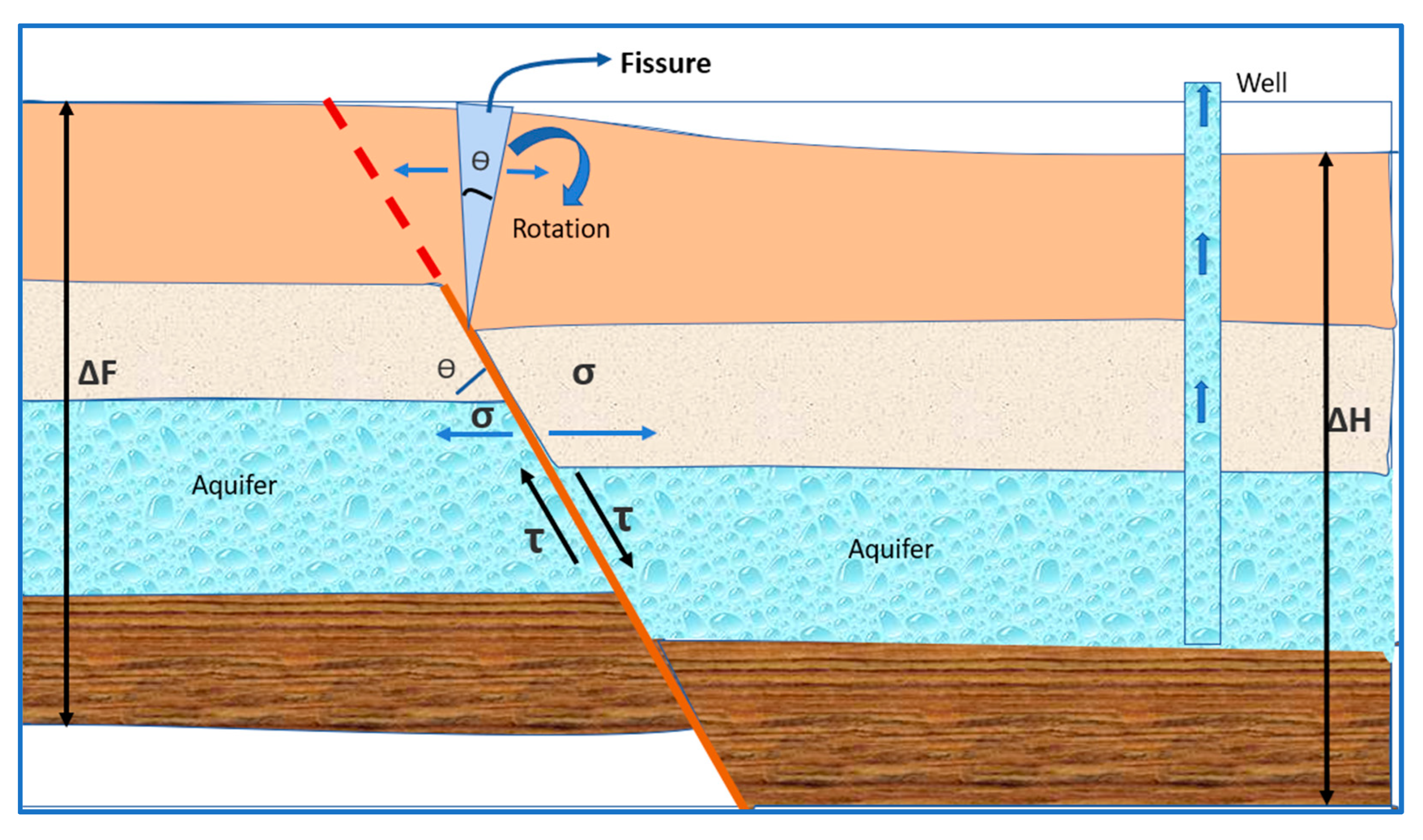
3.1.2. Pre-Existence of Faults

Existing faults in constant shear states may become more active and stretch to the ground surface, causing cracks in the hanging fault block. Besides that, sustained aquifer depletion in such an area can cause the faults’ hanging wall to consolidate and settle, increasing the unequal settlement on both blocks of the faults and hastening the mobility and formation of the ground fissure [70]. Fault zones and buried fault scarps can have an impact on the accumulation of stresses over time. The faulted zones have a considerable influence on extensional and compressional patterns, whereas the buried fault scarp has a greater impact on shear stress patterns. Ref. [58] discovered that a fissure caused by tension is near the faulted block at the sliding wall, affirming that fissures begin near the surface and make their way downward, terminating near the boundary between the saturated and unsaturated column. The presence of a fault zone has been established as a determinant in a fissure’s propagation course. This was further confirmed by the authors of [28], who used site evaluation, drilling, and trench unearthing to define and assess the basis for fissure formation in Qinglong Gaben, China. Syn-sedimentary faults, as well as an excessive drawdown of groundwater and erosion processes, were shown to be major drivers in the creation and multiplication of fissures in the region, according to the research. Recent research has revealed that earth fissure cluster formation is polygenetic and the result of the earth’s internal forces and anthropogenic actions. The origination of fault-induced earth cracks can be subdivided into three developmental phases: first, initial extension resulting from fault planes underground, followed by the excessive pumping of groundwater, and then, washouts aided by the development of the fissure. Deep crustal movements underneath the basin influence earth fissuring, which is driven by the local geodynamic stress of the nearby fault zones [71]. The fault displacement increases as the depth of the fault grows, which is typical of synthetic and other syn-depositional faults. Vertical displacement characterizes these fissures, which can have a yearly growth rate that ranges from 1 to 3 cm. The tectonic structure of a basin’s hidden faults is thought to have an influence on the formation of large-scale fissures, which may also be influenced by the basin’s regional extensional stress. Over-exploitation of groundwater further increases the level of activities leading to fissure formation [72]. As a result, groundwater exploitation is an important contributor to fault-induced earth fissure development. Intensive groundwater extraction results in the establishment of an inner multi-directional (radial) compression zone near pumping wells and an external radial tensional zone outside them. Lateral tensile stress (σ) minimizes the resisting force on the fissure surface and increases its activation in fissures in the external radial tensional zone. If a well is bored in one of the fault compartments, for example, the rate of the water table decrease in the sliding (or hanging) wall will be faster than it is in the footwall, resulting in more shear stress (τ) in the vertical plane of the fissure. Unequal surface settling (ΔH > ΔF) causes tensional stress around the ground fissure, which encourages fissure migration and expansion as shown in Figure 5. The sediment thickness in the hanging wall is generally greater than thickness of the accumulated sediment in the footwall due to the build-up of pre-existing faults. Fissuring can form aberrant layer placements and subsequently stretch to pre-existing faults as groundwater pumping intensifies.

3.2. Non-Tectonic Mechanisms

3.2.1. Existence of Paleochannels

Paleochannels affect the creation of rock fissures, which are commonly caused by intense rains, squeezing, or earthquakes, and inadequate groundwater pumping [73,74]. It creates an ideal environment for fissure formation [71]. Because of the inhomogeneity, anisotropy, and friability of shallowly buried ancient channel deposits, instabilities and uneven settling are common, resulting in fissure development, piping, and surface erosion, among other things, and human activities hasten this process. Earth fissures linked with paleochannels have short lengths and superficial depths overall, as well as the forming trend of earth fissures on the edges of paleochannels, which reflects the channel’s meandering model [73,75]. Due to gravitational force and extra pressures, the top has strata curves and breaks above the empty spaces when unequal vertical strain occurs in the compressible layer. According to a theoretical examination of their characteristics, channel controlled fissures are generated by gravity, initial joint stresses, and groundwater withdrawal operations, and are driven by paleo-fluvial factors [74]. The base of paleochannel-induced fissures usually coincides with curving or meandering surfaces or gradational zones between valley slopes and terraces, implying that they are generated by the self-weight of overlying strata [75].

3.2.2. Collapsibility of Loess

In recent years, experts have become increasingly interested in nontectonic ground cracks. Nontectonic ground fissures were explored, and their causes were investigated in [6,29]. They used field study, trenching, and geotechnical testing to conclude that nontectonic ground cracks are mostly caused by loess collapsibility [6], determined that earth cracks are produced by loess collapsibility and erosion is caused by infiltration, and that loess cracks create a favorable environment for the creation of earth fissures. The studies reached these conclusions by studying groundwater variability, topology, soil physico-mechanical indexes, as well as the lithological backdrop. Ref. [26] looked at the relationship connecting four soft soil properties and earth fissuring: density of dry loess, its porosity, water saturation, and self-gravity collapsibility coefficient. They described how earth fissures are generated by employing the spinning mechanism of a loess cantilever beam, as well as the computation equation of tensile force. Although the following research on fissures caused by factors other than tectonic forces has distinct foci and creation mechanisms, they all agree that nontectonic fissure formation is linked to the ability of loess to collapse and allow fluids to infiltrate. According to [24], all fissures formed by soil collapsibility go through a phase from emergence to maturity, starting with microcracks and ending with eroded fissures as broad as gullies. It is said that as surface water accumulates and infiltrates into the ground, the wetness of the soil increases while its tensile strength falls, causing fissures to form. The saturation of collapsible soil occurs because of water infiltration, which is followed by hydro-compaction and the creation of new nascent hairline fissures. Additional water infiltrates inside the subsurface through tiny cracks, eroding telescopic soils and forming underground passageways that are not obvious on the earth’s surface in the initial state of growth and can only be observed through some cave-ins along the fissures. More water erosion broadens and increases the subway, causing the roofs to collapse and forming pits along the fissures. Finally, owing to piping erosion, these potholes connect, producing more collapse. Continuous erosion enlarges the collapsed structures and transforms them into eroded gullies, which are the mature stage of the fissures.

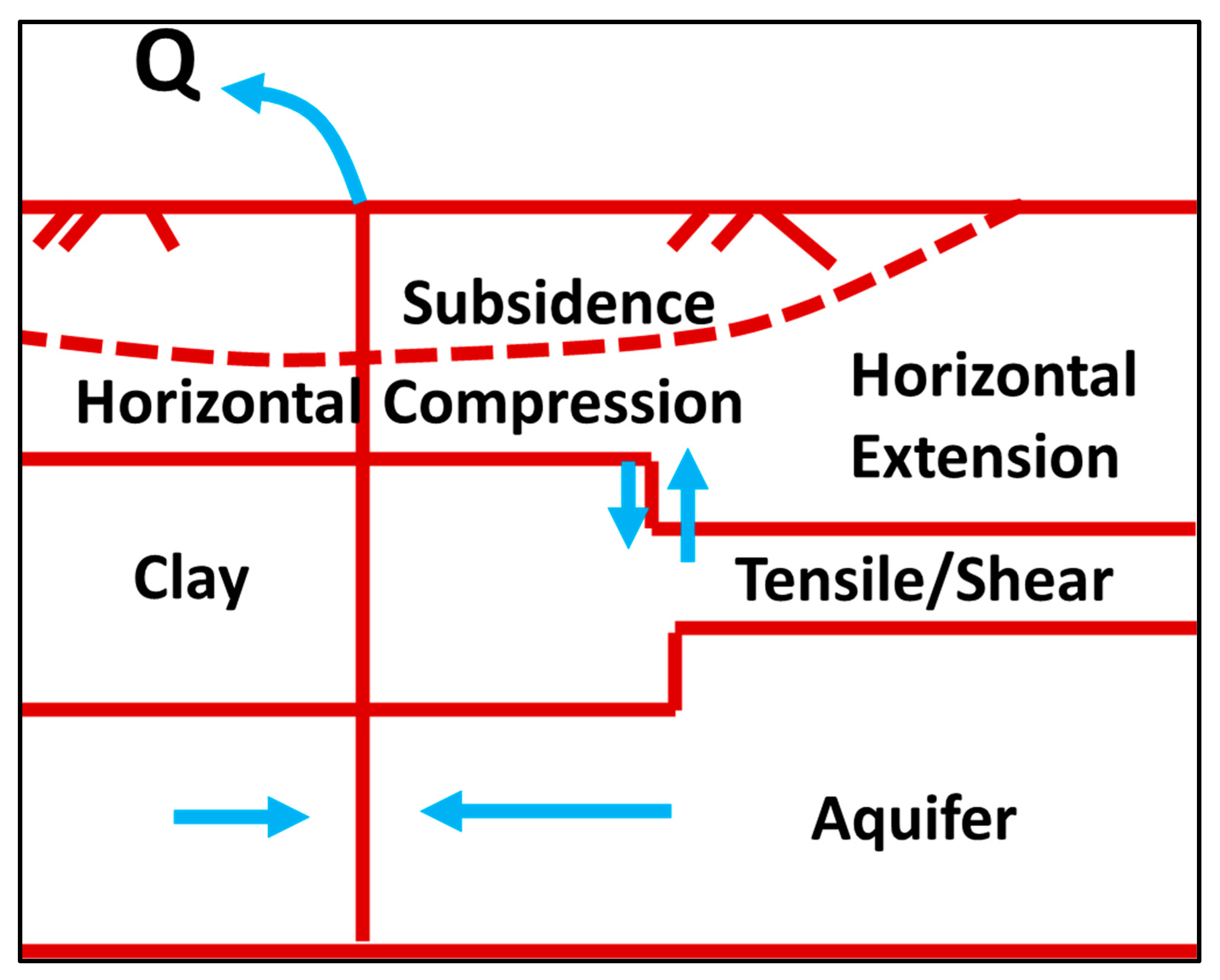
3.2.3. Differential Compaction Due to Heterogeneity

Aquifer heterogeneity results in a sudden shift in an aquifer’s thickness or in its bed composition. According to [53], such thickness fluctuations could lead to rotation, vertical shear, or even lateral expansion at depth. For instance, the author in [56] illustrated that the vertical compaction strength varies on either side of a geometric heterogeneity. He explained that localized differential vertical movement in the underlying, non-compacting interval is caused by a geometric anomaly that migrates upward, causing tilting and shearing at the surface of the terrain. On the other hand, localized differential horizontal distortions may cause fissures at the ground surface as well as a deep extensional zone and induce an opposite direction of rotation (see Figure 6).
The ongoing discussion is summarized in Table 3, which highlights the major factors and processes of fissure formation as discussed above. Other anthropogenic factors and processes such as groundwater over-pumping is an integral part of the processes discussed above since they facilitate them.

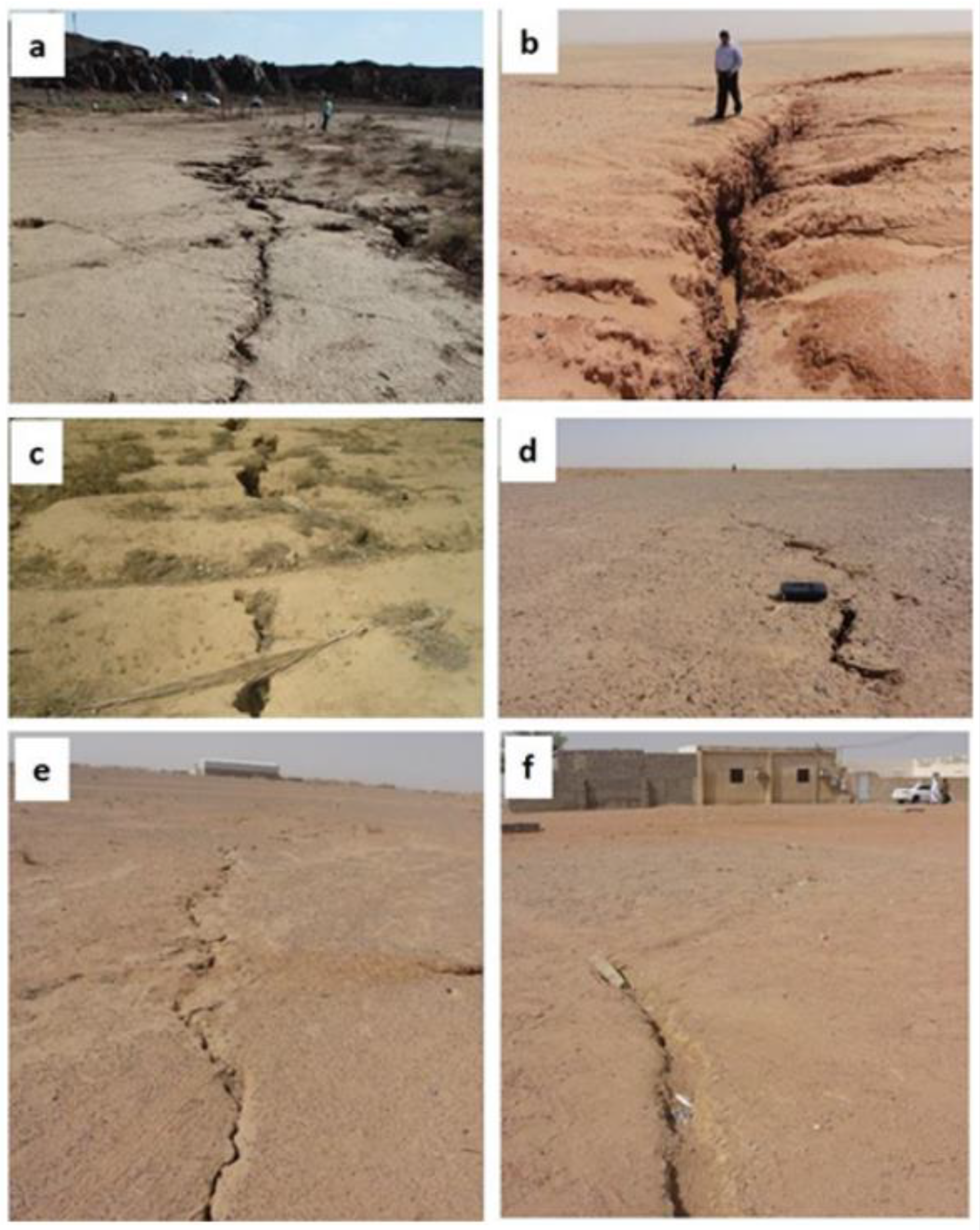
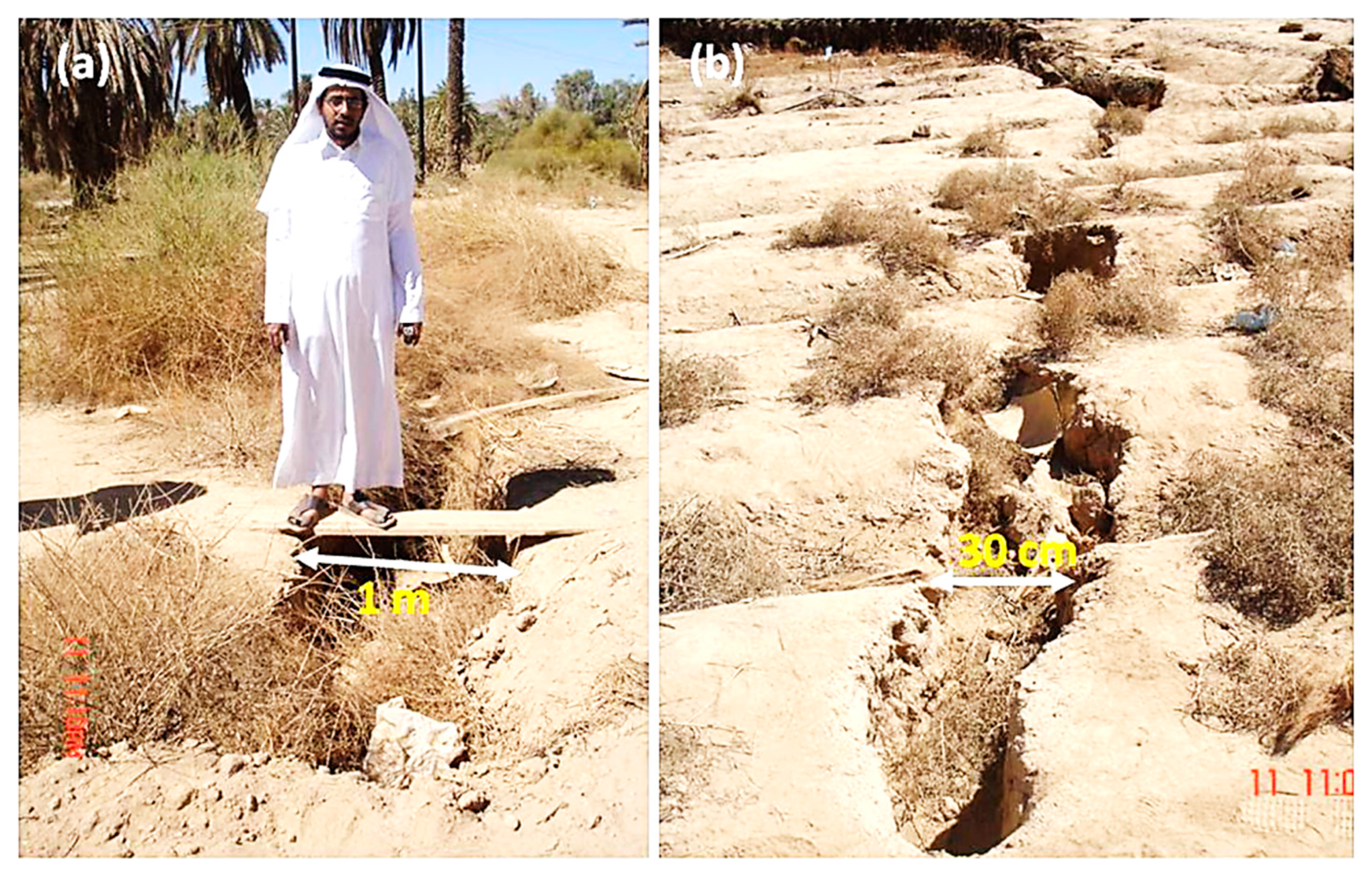
4. Earth Fissures in Najran

From the previous discussion, we can see that it is a popular opinion among researchers that groundwater depletion makes a significant contribution to the formation of fissures. Researchers have attributed inadequate groundwater removal as the primary cause of land subsidence and earth fissures in several locations throughout the Kingdom of Saudi Arabia [2,32,34,76]. Ref. [34] highlighted the diverse kinds of ground fissures (Figure 7) found in the country based on their various causative factors, some of which include (a) earth fissures induced by the excessive withdrawal of groundwater; (b) earth fissures due to the swelling and shrinkage of clay deposits such as in Hail, Al Qasim; (c) earth fissures caused by dewatering impacts on Khabra deposits, such as in the Al Qasim geopolitical zone; (d) ground fissuring connected to subsurface structures and groundwater over-pumping; and (e,f) earth fissures emanating from the effects of an earthquake.
A study conducted in [2] estimated that the city of Najran witnesses only about 31.3 × 10⁶ m3 rainfall per year. This is the reason for the constant reduction in water table levels, which caused the drying of more than a thousand wells in the city. Rapid groundwater depletion remains one of the most profound sustainability challenges facing many cities. In Najran, the authors in [2] indicated that the Najran fissures have varying lengths and widths; one of the fissures elongated to about 600 m in a northeast direction and has a varying breadth of thirty or fifty centimeters (see Figure 8). Although these reported initial widths of the fissures might seem small, the authors in [77] asserted from their investigation of fissures in south–central Arizona that similar fissures being initially narrow and having a width of about 2 cm wide and 1–2 km long, widen and elongate as time passes. As discussed above, in Section 2, the length of the fissures or the extent of deformations resulting from fissuring activity typically depends on the underlying geology of the area, with causes such as pre-existing faults, the degree of groundwater depletion, and the resultant pressure imbalance. As reported from a survey carried out in Su-Xi-Chang Plain, in the southeastern part of the North China Plain, earth fissures can be up to two thousand meters long [20]. It is therefore acceptable to presume that earth fissures in Najran might become worse than they are presently.
In Najran, most exposed ground fissures caused by groundwater depletion appear on the surface as linear ruptures with some vertical displacements, and the resulting surface scarps result in myriad destruction on roadways, farms, and residences with a range of influence of 30 to 400 m. Due to tensile forces caused by excessive groundwater extraction, earth cracks in the city of Najran can stretch for tens of meters to kilometers [51]. Studies have shown that Najran’s earth fissures are linked to groundwater depletion ((Interdisciplinary Earthquake Hazard Research in Gulf of Aqaba and Strait of Tiran (GAST)-NASA/ADS, n.d.) [34,78]. The rapid drop in the water table level caused subsidence as well as ground failure, which was evidenced by earth rifts, owing to the aquifer’s composition of poorly consolidated sands with high porosity and aquitards with low pore connectivity and high compressibility [2,34]. If increased water exploitation in the city of Najran persists, fissuring and some other environmental threats including sinkholes, seismic events, and structural failure to engineering constructions will also persevere, causing the size of existing subsidence and fissures throughout the location to grow even larger [15].
Research has proven that factors causing the formation of fissures are synergistic, implying that, although groundwater depletion triggers or enhances the process, other pre-existing geologic tectonic and nontectonic factors play major roles in enabling their formation [23]. Apart from the excessive drawdown of the groundwater table in Najran, the subsurface topography of the study area has been also suggested as a major factor contributing to the formation of the fissures in that area. As discussed earlier, subsurface slopes such as bedrock ridges can influence the formation of fissures [21,58]. This secondary cause of the Najran fissure was proposed by the authors in [2], who used advanced electrical resistivity tomography (ERT) to evaluate the subsurface extent, topological information, and the spread of fissures in the Najran metropolis.
Several regional and local active seismic zones have been reported in the western region of Saudi Arabia, including the Red Sea, the Gulf of Aqaba, and the Najid Fault system in addition to many others that can potentially accommodate different magnitudes of earthquakes such as the destructive 1993 (Mw 6.1) and 1995 (Mw 7.3) earthquakes that occurred in the Gulf of Aqaba [79,80]. These seismic zones activate tectonic deformation of the earth and consequent faulting across the region, and the city of Najran, being in the western region, is not entirely free from their impacts. The Wajid Group which underlies the city of Najran is reported to be fractured on a regional scale as a result of the paleo reactivation of the Arabian Shield structures [42]. These structures can be easily reactivated due to the stress imbalance accruing from excessive groundwater pumping. Although it has been suggested that subsurface topography is a key factor in the fissure’s formation, it is not exhaustive and can be an insignificant contributor to the fissuring process. It is, therefore, required to conduct fault or fracture mapping studies across the fissuring zones. An in-depth understanding of the structural architecture and fault history of the Najran Basin would be an immense guide toward understanding other unknown factors responsible for fissuring in the area. There is a need to conduct further research into the other potential causes of this hazard. A robust understanding of this would enable the government to develop holistic mitigation and control measures to protect life and properties in the area.

4.1. Najran Fissure Monitoring Recommendation

So many arithmetical, theoretic, geomechanical, and physics models have earlier been established to explore the configurations, tensile forces, and resumption of fissuring predicated on underground water lateral motion, drainage, agrarian operations, subsidence, continuous soil cracking, bedrock characteristics, and aquifer/aquitard layer thickness, as evidenced by the ongoing discussions in the literature [29,81,82,83,84,85]. We have shown that the factors responsible for fissuring in Najran are multifaceted and may be more serious than previously thought. If all the probable sources of hazard are identified, they can be combined to create more robust conceptual and/or predictive models of the fissure development mechanism in the area. It is especially important to have a holistic model of the earth fissure hazards in the area to recognize susceptible groundwater areas for the proper enactment of water management policies and efficacious implementation of groundwater recharge strategies to achieve environmentally friendly preservation plans and protect existing groundwater resources [86]. Predicting and comprehending hazardous locations can assist policymakers in managing susceptible areas and reducing the likelihood of damage. The findings would also be useful for water resource managers in formulating judgments on how to properly regulate groundwater extraction. To investigate the creation mechanism of fissuring in Najran, statistically based models such as time series models or artificial intelligence (AI) can be applied. These models would primarily be used to monitor active fissures and identify key factors, utilizing spatial information, subsidence, groundwater-related data sets, etc. [85,86,87,88,89]. As discussed by the authors of [90] for landslide prediction, metaheuristic algorithms such as artificial bee colony (ABC), genetic algorithms (GAs), [90,91,92,93], gray wolf optimization (GWO) algorithms [94,95], particle swarm optimization (PSO) algorithms [96,97], and water cycle algorithms (WCAs) [97] can also be implemented for fissure predictions. Ref. [90] further demonstrates that a combined application integrating k-fold cross-validation, metaheuristic support vector regression, and nonparametric Friedman tests can be utilized to determine optimum hyperparameters and present their statistical significance, thereby improving the accuracy and dependability of AI-based forecasts, and with the help of these methods, different machine-learning-based geo-hazard models might be analyzed and contrasted to ensure high prediction precision [98].

4.2. Future Fissure Studies in Najran

It is suggested that fissure-related studies in Najran and the surrounding cities focus on identifying all the major potential contributors to their formation processes, as well as assessing the contribution of an ephemeral variability of predictors such as rainfall, groundwater drawdown, groundwater variability, and so on, in order to develop a reliable model that can be utilized to forecast and monitor fissure formation in the area. This would be a great opportunity to learn more about the earth fissures. The primary determinants in fissure formation can be revealed through a sensitivity analysis of the predictors. Future findings could serve as a foundation for fissure research in other sections of Saudi Arabia and beyond. The increased demand for the prediction of possible hazards and susceptibility mapping can be met by constructing a credible fissuring model [7,99,100,101,102]. Irregular bedrock topography, low groundwater recharge, excessive aquifer depletion, water table decline, a high density of groundwater wells, a high density of constructed roads, collapsible sediment distribution, fault zones, and other factors could make these areas more vulnerable to fissure hazards, and an accurate predictive model could help the government monitor these areas.

5. Conclusions

The factors that cause fissures are complex and synergistic. The investigation of this danger in many areas has revealed that multiple elements contribute to its creation. Because of the stress imbalance caused by groundwater extraction, pre-existing geologic features such as faults, fractures, joints, or sloppy terrain are mostly activated. The likelihood of pre-existing underground faults being activated by excessive groundwater extraction is quite likely, given the fracture history of the underlying geology of the city of Najran. Because prior studies of the fissures in this area failed to account for pre-existing faults or channels, future research should concentrate on this and other potential variables. Moreover, additional research might focus on finding all probable fissure predictors in this area and constructing holistic, realistic, and efficient predictive models that could be used to monitor areas with significant fissuring potentials. Such models would aid the government in making critical choices on facility development, city planning, agricultural expansion, and groundwater extraction regulation for both irrigation and domestic use.

Author Contributions

Conceptualization, B.O.N. and M.H.; methodology, B.O.N.; validation, A.M.H.H.M. and M.H.; writing—original draft preparation, B.O.N.; writing—review and editing, M.A. and M.I.; supervision, M.H. and A.M.H.H.M.; project administration, M.H.; funding acquisition, A.M.H.H.M. All authors have read and agreed to the published version of the manuscript.

Funding

This research received no external funding.

Institutional Review Board Statement

Not applicable.

Informed Consent Statement

Not applicable.

Data Availability Statement

Not applicable.

Acknowledgments

The authors are thankful to the Deanship of Scientific Research at Najran University for funding this work under the National Research Priorities Funding program grant code (NU/NRP/SERC/11/1). We also acknowledge the In-ternational Grant (015ME0-310) for supporting and funding this project. We also appreciate everyone who took the time to comment on this piece during the discussion and critical review stages.

Conflicts of Interest

The authors declare no conflict of interest. The funders had no role in the design of the study; in the collection, analyses, or interpretation of data; in the writing of the manuscript; or in the decision to publish the results.

References

  1. Conway, B.D. Land subsidence and earth fissures in south-central and southern Arizona, USA. Hydrogeol. J. 2015, 24, 649–655. [Google Scholar] [CrossRef]
  2. Youssef, A.M.; Sabtan, A.A.; Maerz, N.H.; Zabramawi, Y.A. Earth fissures in Wadi Najran, kingdom of Saudi Arabia. Nat. Hazards 2013, 71, 2013–2027. [Google Scholar] [CrossRef]
  3. Huang, G.; Liu, C.; Sun, J.; Zhang, M.; Jing, J.; Li, L. A regional scale investigation on factors controlling the groundwater chemistry of various aquifers in a rapidly urbanized area: A case study of the Pearl River Delta. Sci. Total Environ. 2018, 625, 510–518. [Google Scholar] [CrossRef]
  4. Zhu, H.-H.; Shi, B.; Zhang, C.-C. FBG-based monitoring of geohazards: Current status and trends. Sensors 2017, 17, 452. [Google Scholar] [CrossRef] [PubMed] [Green Version]
  5. Liao, F.; Wang, G.; Shi, Z.; Huang, X.; Xu, F.; Xu, Q.; Guo, L. Distributions, sources, and species of heavy metals/trace elements in shallow groundwater around the Poyang lake, East China. Expo. Health 2017, 10, 211–227. [Google Scholar] [CrossRef]
  6. Zhang, F.; Huang, G.; Hou, Q.; Liu, C.; Zhang, Y.; Zhang, Q. Groundwater quality in the Pearl River Delta after the rapid expansion of industrialization and urbanization: Distributions, main impact indicators, and driving forces. J. Hydrol. 2019, 577, 124004. [Google Scholar] [CrossRef]
  7. Howard, K.W.F.; Zhou, W. Overview of ground fissure research in China. Environ. Earth Sci. 2019, 78, 97. [Google Scholar] [CrossRef]
  8. Feng, Y.; Xiang-Yang, L. Improving emergency response to cascading disasters: Applying case-based reasoning towards urban critical infrastructure. Int. J. Disaster Risk Reduct. 2018, 30, 244–256. [Google Scholar] [CrossRef]
  9. Li, Z.; Lai, J.; Li, Y.; Qiu, J.; Shi, Y.; Li, B.; Fan, F. Ground fissure disasters and mitigation measures for hazards during metro system construction in Xi’an, China. Arab. J. Geosci. 2021, 15, 5. [Google Scholar] [CrossRef]
  10. Al-Harthi, A.A.; Bankher, K.A. Collapsing loess-like soil in western Saudi Arabia. J. Arid. Environ. 1999, 41, 383–399. [Google Scholar] [CrossRef] [Green Version]
  11. Singh, A.; Mishra, O. Seismological evidence for monsoon induced micro to moderate earthquake sequence beneath the 2011 Talala, Saurashtra earthquake, Gujarat, India. Tectonophysics 2015, 661, 38–48. [Google Scholar] [CrossRef]
  12. Bankher, K.A.; Al-Harthi, A.A. Earth fissuring and land subsidence in Western Saudi Arabia. Nat. Hazards 1999, 20, 21–42. [Google Scholar] [CrossRef]
  13. El Baruni, S.S. Earth fissures caused by groundwater withdrawal In Sarir south agricultural project area, Libya. Hydrogeol. J. 1994, 2, 45–52. [Google Scholar] [CrossRef]
  14. Hauksson, E. Episodic rifting and volcanism at Krafla in north Iceland: Growth of large ground fissures along the plate boundary. J. Geophys. Res. Atmos. 1983, 88, 625–636. [Google Scholar] [CrossRef]
  15. El Aal, A.A.; Kamel, M.; Al-Homidy, A. Using remote sensing and GIS techniques in monitoring and mitigation of geohazards in Najran Region, Saudi Arabia. Geotech. Geol. Eng. 2019, 37, 3673–3700. [Google Scholar] [CrossRef]
  16. Wang, Z.-F.; Shen, S.-L.; Cheng, W.-C.; Xu, Y.-S. Ground fissures in Xi’an and measures to prevent damage to the Metro tunnel system due to geohazards. Environ. Earth Sci. 2016, 75, 511. [Google Scholar] [CrossRef]
  17. Helm, D.C. Hydraulic forces that play a role in generating fissures at depth. Environ. Eng. Geosci. 1994, xxxi, 293–304. [Google Scholar] [CrossRef]
  18. Xu, J.; Peng, J.; An, H. Experimental study on Su-Xi-Chang earth fissures induced by repeated groundwater pumping and impounding. Geomat. Nat. Hazards Risk 2019, 10, 2051–2068. [Google Scholar] [CrossRef]
  19. Burbey, T. The influence of faults in basin-fill deposits on land subsidence, Las Vegas Valley, Nevada, USA. Hydrogeol. J. 2002, 10, 525–538. [Google Scholar] [CrossRef]
  20. Budhu, M. Earth fissure formation from the mechanics of groundwater pumping. Int. J. Geéomeéch. 2011, 11, 1–11. [Google Scholar] [CrossRef]
  21. Hernandez-Marin, M.; Burbey, T.J. The role of faulting on surface deformation patterns from pumping-induced groundwater flow (Las Vegas Valley, USA). Hydrogeol. J. 2009, 17, 1859–1875. [Google Scholar] [CrossRef]
  22. Xu, J.; Meng, L.; An, H.; Wang, L. The bending mechanism of Anping ground fissure in the Hebei Plain, North China. Environ. Earth Sci. 2015, 74, 6859–6870. [Google Scholar] [CrossRef]
  23. Qiao, J.; Peng, J.; Deng, Y.; Leng, Y.; Meng, Z. Earth fissures in Qinglong Graben in Yuncheng Basin, China. J. Earth Syst. Sci. 2018, 127, 10. [Google Scholar] [CrossRef] [Green Version]
  24. Nikbakhti, O.; Hashemi, M.; Banikheir, M.; Basmenj, A.K. Geoenvironmental assessment of the formation and expansion of earth fissures as geological hazards along the route of the Haram-to-Haram Highway, Iran. Bull. Eng. Geol. Environ. 2017, 77, 1421–1438. [Google Scholar] [CrossRef]
  25. Othman, A.; Sultan, M.; Becker, R.; Sefry, S.; Alharbi, T.; Alharbi, H.; Gebremichael, E. Groundwater-related land deformation over the mega aquifer system in Saudi Arabia: Inferences from InSAR, GRACE, earthquake records, field, and spatial data analysis. In Proceedings of the American Geophysical Union, Fall Meeting, New Orleans, LA, USA, 11–15 December 2017. Abstract #NH31B-0217. [Google Scholar]
  26. Lu, Q.; Qiao, J.; Peng, J.; Liu, Z.; Liu, C.; Tian, L.; Zhao, J. A typical Earth fissure resulting from loess collapse on the loess plateau in the Weihe Basin, China. Eng. Geol. 2019, 259, 105189. [Google Scholar] [CrossRef]
  27. Wang, F.; Peng, J.; Meng, Z.; Qiao, J.; Wen, H.; Ma, P.; Liu, Y.; Jia, Z.; Zhao, J. The origin and impact of the Shizhuang ground fissure, Yingxian area, Datong Basin, China. Eng. Geol. 2019, 261, 105283. [Google Scholar] [CrossRef]
  28. Wan, J.; Li, B.; Tan, C.; Feng, C.; Zhang, P.; Qi, B. Characteristics and main causes of earth fissures in northeastern Beijing Plain, China. Bull. Eng. Geol. Environ. 2020, 79, 2919–2935. [Google Scholar] [CrossRef]
  29. Lu, Q.; Liu, Y.; Peng, J.; Li, L.; Fan, W.; Liu, N.; Sun, K.; Liu, R. Immersion test of loess in ground fissures in Shuanghuaishu, Shaanxi Province, China. Bull. Eng. Geol. Environ. 2020, 79, 2299–2312. [Google Scholar] [CrossRef]
  30. Wang, G.Y.; You, G.; Shi, B.; Qiu, Z.L.; Li, H.Y.; Tuck, M. Earth fissures in Jiangsu Province, China and geological investigation of Hetang earth fissure. Environ. Earth Sci. 2010, 60, 35–43. [Google Scholar] [CrossRef]
  31. Zang, M.; Peng, J.; Xu, N.; Jia, Z. A probabilistic method for mapping earth fissure hazards. Sci. Rep. 2021, 11, 8841. [Google Scholar] [CrossRef]
  32. Shehata, W.; Amin, A. Geotechnical hazards associated with desert environment. Nat. Hazards 1997, 16, 81–95. [Google Scholar] [CrossRef]
  33. Al-Shanti, A.; El-Mahdy, O.; Hassan, M.; Hussein, A. A comparative study of five volcanic-hosted sulfide mineralizations in the Arabian shield. J. King Abdulaziz Univ. Sci. 1993, 6, 1–33. [Google Scholar] [CrossRef]
  34. Youssef, A.M.; Al-Harbi, H.M.; Zabramwi, Y.A.; El-Haddad, B.A. Human-Induced Geo-Hazards in the Kingdom of Saudi Arabia: Distribution, Investigation, Causes and Impacts. In Geohazards Caused by Human Activity; InTech: London, UK, 2016. [Google Scholar] [CrossRef]
  35. Edgell, H.S. Basement tectonics of Saudi Arabia as related to oil field structures. In Basement Tectonics 9. Proceedings of the International Conferences on Basement Tectonics, Canberra, Australia, July 1990; Rickard, M.J., Harrington, H.J., Williams, P.R., Eds.; Springer: Berlin/Heidelberg, Germany, 1992; Volume 3, p. 3. [Google Scholar] [CrossRef]
  36. Al-Husseini, M.I. Origin of the Arabian Plate structures: Amar collision and Najd Rift. Geoarabia 2000, 5, 527–542. [Google Scholar] [CrossRef]
  37. Sharland, P.R.; Casey, D.M.; Davies, R.B.; Simmons, M.D.; Sutcliffe, O.E. Arabian plate sequence stratigraphy—Revisions to SP2. Geoarabia 2004, 9, 199–214. [Google Scholar] [CrossRef]
  38. Beydoun, Z.R. Arabian Plate Hydrocarbon Geology and Potential—A Plate Tectonic Approach; American Association of Petroleum Geologists: Tulsa, OK, USA, 1991; Volume 33, p. 77. [Google Scholar]
  39. Bosworth, W.; Huchon, P.; McClay, K. The Red Sea and gulf of Aden basins. J. Afr. Earth Sci. 2005, 43, 334–378. [Google Scholar] [CrossRef]
  40. Davies, F.B. Strain analysis of wrench faults and collision tectonics of the Arabian-Nubian Shield. J. Geol. 1984, 92, 37–53. [Google Scholar] [CrossRef]
  41. Faqira, M.; Rademakers, M.; Afifi, A.M. New insights into the Hercynian Orogeny, and their implications for the Paleozoic Hydrocarbon system in the Arabian Plate. Geoarabia 2009, 14, 199–228. [Google Scholar] [CrossRef]
  42. Benaafi, M.; Hariri, M.; Abdullatif, O.; Makkawi, M.; Al-Shaibani, A. Analysis of lineaments within the Wajid Group, SW Saudi Arabia, and their tectonic significance. Arab. J. Geosci. 2017, 10, 106. [Google Scholar] [CrossRef]
  43. Kellogg, K.S.; Smith, C.W. Geology and tin-greisen mineralization of the Akash granite, northern Arabian Shield. J. Afr. Earth Sci. 1983 1986, 4, 205–210. [Google Scholar] [CrossRef]
  44. Powers, R.; Ramirez, L.F.; Redmond, C.; Elberg, E. Geology of the Arabian Peninsula: Sedimentary geology of Saudi Arabia; U.S. Geological Survey: Asheville, NC, USA, 1966. [Google Scholar] [CrossRef] [Green Version]
  45. Stump, T.; Van der Eem, J. The stratigraphy, depositional environments and periods of deformation of the Wajid outcrop belt, southwestern Saudi Arabia. J. Afr. Earth Sci. 1995, 21, 421–441. [Google Scholar] [CrossRef]
  46. Al-Ajmi, H.F.; Keller, M.; Hinderer, M.; Filomena, C.M. Lithofacies, depositional environments and stratigraphic architecture of the Wajid Group outcrops in southern Saudi Arabia. Geoarabia 2015, 20, 49–94. [Google Scholar] [CrossRef]
  47. Abdulkadir, I.T.; Abdullatif, O.M. Facies, depositional environments, reservoir potential and palaeogeography of the cambro-ordovician dibsiyah formation, Wajid outcrop belt, Saudi Arabia. Arab. J. Sci. Eng. 2012, 38, 1785–1806. [Google Scholar] [CrossRef]
  48. Laboun, A.A. Paleozoic tectono-stratigraphic framework of the Arabian Peninsula. J. King Saud Univ. Sci. 2010, 22, 41–50. [Google Scholar] [CrossRef] [Green Version]
  49. Knox, R.W.; Franks, S.G.; Cocker, J.D. Stratigraphic evolution of heavy-mineral provenance signatures in the sandstones of the Wajid Group (Cambrian to Permian), southwestern Saudi Arabia. Geoarabia 2007, 12, 65–96. [Google Scholar] [CrossRef]
  50. Al-Husseini, M.I. Pre-Unayzah unconformity, Saudi Arabia. In Carboniferous, Permian and Early Triassic Arabian Stratigraphy; Gulf PetroLink: Manama, Bahrain, 2014. [Google Scholar]
  51. Holzer, T.L. Ground failure induced by ground-water withdrawal from unconsolidated sediment. In Man-Induced Land Subsidence; Geological Society of America: Boulder, CO, USA, 1984; Volume 6. [Google Scholar]
  52. Lofgren, B.E. Hydraulic stresses cause ground movement and fissures, Picacho, Arizona. In Geological Society of America Abstracts with Programs; Geological Society America: Boulder, CO, USA, 1978; Volume 10, p. 113. [Google Scholar]
  53. Helm, D.C. Horizontal aquifer movement in a Theis-Thiem confined system. Water Resour. Res. 1994, 30, 953–964. [Google Scholar] [CrossRef]
  54. Zhang, Y.; Xue, Y.-Q.; Wu, J.-C.; Yu, J.; Wei, Z.-X.; Li, Q.-F. Land subsidence and earth fissures due to groundwater withdrawal in the Southern Yangtse Delta, China. Environ. Geol. 2007, 55, 751–762. [Google Scholar] [CrossRef]
  55. Xu, J.; Peng, J.; Deng, Y.; Wang, F. Development characteristics and formation analysis of Baixiang earth fissure on North China plain. Bull. Eng. Geol. Environ. 2018, 78, 3085–3094. [Google Scholar] [CrossRef]
  56. Sheng, Z.; Helm, D.C.; Li, J. Mechanisms of earth fissuring caused by groundwater withdrawal. Environ. Eng. Geosci. 2003, 9, 351–362. [Google Scholar] [CrossRef]
  57. Higgins, C.G.; Coates, D.R. Groundwater Geomorphology: The Role of Subsurface Water in Earth-Surface Processes and Landforms; Geological Society of America: Boulder, CO, USA, 1990. [Google Scholar]
  58. Hernandez-Marin, M.; Burbey, T.J. Controls on initiation and propagation of pumping-induced earth fissures: Insights from numerical simulations. Hydrogeol. J. 2010, 18, 1773–1785. [Google Scholar] [CrossRef]
  59. Gregory, J.; Mueller, J.E. Earth fissures of the Mimbres Basin, southwestern New Mexico. New Mex. Geol. 1991, 13, 69–74. [Google Scholar]
  60. Budhu, M.; Adiyaman, I. Earth fissure formation from groundwater pumping and the influence of a stiff upper cemented layer. Q. J. Eng. Geol. Hydrogeol. 2012, 45, 197–205. [Google Scholar] [CrossRef]
  61. Budhu, M.; Adiyaman, I. The influence of clay zones on land subsidence from groundwater pumping. Groundwater 2013, 51, 51–57. [Google Scholar] [CrossRef]
  62. Aisong, D.; Jianhua, J. Land subsidence, sinkhole collapse and earth fissure occurrence and control in China. Hydrol. Sci. J. 1994, 39, 245–256. [Google Scholar] [CrossRef]
  63. Burbey, T.J. Storage coefficient revisited: Is purely vertical strain a good assumption? Groundwater 2001, 39, 458–464. [Google Scholar] [CrossRef] [PubMed]
  64. Burbey, T.J. Stress-strain analyses for aquifer-system characterization. Groundwater 2001, 39, 128–136. [Google Scholar] [CrossRef]
  65. Bawden, G.W.; Thatcher, W.; Stein, R.S.; Hudnut, K.W.; Peltzer, G. Tectonic contraction across Los Angeles after removal of groundwater pumping effects. Nature 2001, 412, 812–815. [Google Scholar] [CrossRef]
  66. Hsieh, P.A. Deformation-induced changes in hydraulic head during ground-water withdrawal. Groundwater 1996, 34, 1082–1089. [Google Scholar] [CrossRef]
  67. Wolff, R.G. Relationship between horizontal strain near a well and reverse water level fluctuation. Water Resour. Res. 1970, 6, 1721–1728. [Google Scholar] [CrossRef]
  68. Budhu, M.; Adiyaman, I.B. Mechanics of land subsidence due to groundwater pumping. Int. J. Numer. Anal. Methods Geéomeéch. 2009, 34, 1459–1478. [Google Scholar] [CrossRef]
  69. Jachens, R.C.; Holzer, T.L. Differential compaction mechanism for earth fissures near Casa Grande, Arizona. GSA Bull. 1982, 93, 998–1012. [Google Scholar] [CrossRef]
  70. Zhao, J.; Liu, C.; Peng, J.; Qiao, J.; Meng, Z.; Wen, H.; Wang, F.; Ma, P.; Wang, Z.; Jia, Z.; et al. Characteristics and formation mechanism of the Yangjiazhuang-Maguduo ground fissure, western Linfen Basin, Northern China. J. Asian Earth Sci. 2022, 226, 105043. [Google Scholar] [CrossRef]
  71. Peng, J.; Qiao, J.; Sun, X.; Lu, Q.; Zheng, J.; Meng, Z.; Xu, J.; Wang, F.; Zhao, J. Distribution and generative mechanisms of ground fissures in China. J. Asian Earth Sci. 2020, 191, 104218. [Google Scholar] [CrossRef]
  72. Gaur, V.P.; Kar, S.K.; Srivastava, M. Development of ground fissures: A case study from southern parts of Uttar Pradesh, India. J. Geol. Soc. India 2015, 86, 671–678. [Google Scholar] [CrossRef]
  73. Pacheco-Martínez, J.; Hernandez-Marín, M.; Burbey, T.J.; González-Cervantes, N.; Ortíz-Lozano, J.Á.; Zermeño-De-Leon, M.E.; Solís-Pinto, A. Land subsidence and ground failure associated to groundwater exploitation in the Aguascalientes Valley, México. Eng. Geol. 2013, 164, 172–186. [Google Scholar] [CrossRef]
  74. Xu, Z.; Liu, C.; Zhou, X.; Gao, G.; Feng, X. Full-scale physical modelling of fissure grouting in deep underground rocks. Tunn. Undergr. Space Technol. 2019, 89, 249–261. [Google Scholar] [CrossRef]
  75. Xu, J.; Peng, J.; An, H.; Wang, F.; Sun, H.; Hu, H.; Yang, B. Paleochannel-controlled earth fissures in Daming, North China Plain and their implication for underground paleogeomorphology. Geomorphology 2019, 327, 523–532. [Google Scholar] [CrossRef]
  76. Amin, A.; Bankher, K. Geotechnical aspects of loess in kingdom of Saudi Arabia. J. King Abdulaziz Univ. Sci. 2004, 15, 163–179. [Google Scholar] [CrossRef] [Green Version]
  77. Schumann, H.H.; Poland, J.F. Land subsidence, earth fissures and groundwater withdrawal in south-central Arizona, USA. In Proceedings of the International Conference on Land Subsidence, Tokyo, Japan, 1969; Volume 1, pp. 295–302. [Google Scholar]
  78. Mousavi, S.M.; Shamsai, A.; el Naggar, M.H.; Khamehchian, M. A GPS-based monitoring program of land subsidence due to groundwater withdrawal in Iran. Can. J. Civ. Eng. 2001, 28, 452–464. [Google Scholar] [CrossRef]
  79. El-Hussain, I.; Al-Shijbi, Y.; Deif, A.; Mohamed, A.M.E.; Ezzelarab, M. Developing a seismic source model for the Arabian Plate. Arab. J. Geosci. 2018, 11, 435. [Google Scholar] [CrossRef]
  80. Purkis, S.J.; Shernisky, H.; Swart, P.K.; Sharifi, A.; Oehlert, A.; Marchese, F.; Benzoni, F.; Chimienti, G.; Duchâtellier, G.; Klaus, J.; et al. Discovery of the deep-sea NEOM brine pools in the Gulf of Aqaba, Red Sea. Commun. Earth Environ. 2022, 3, 146. [Google Scholar] [CrossRef]
  81. Peng, J.-B.; Chen, L.-W.; Huang, Q.-B.; Men, Y.-M.; Fan, W.; Yan, J.-K. Physical simulation of ground fissures triggered by underground fault activity. Eng. Geol. 2013, 155, 19–30. [Google Scholar] [CrossRef]
  82. Gao, M.; Gong, H.; Li, X.; Chen, B.; Zhou, C.; Shi, M.; Guo, L.; Chen, Z.; Ni, Z.; Duan, G. Land subsidence and ground fissures in Beijing Capital International Airport (BCIA): Evidence from Quasi-PS InSAR analysis. Remote. Sens. 2019, 11, 1466. [Google Scholar] [CrossRef] [Green Version]
  83. Yang, C.-S.; Zhang, Q.; Zhao, C.-Y.; Wang, Q.-L.; Ji, L.-Y. Monitoring land subsidence and fault deformation using the small baseline subset InSAR technique: A case study in the Datong Basin, China. J. Geodyn. 2014, 75, 34–40. [Google Scholar] [CrossRef]
  84. Xulong, G.; Gu, C.; Lu, Y.; Lü, F. Model test for evolution of ground fissures due to extraction of groundwater. J. Eng. Geol. 2018, 26, 951–958. [Google Scholar] [CrossRef]
  85. Robineau, T.; Tognelli, A.; Goblet, P.; Renard, F.; Schaper, L. A double medium approach to simulate groundwater level variations in a fissured karst aquifer. J. Hydrol. 2018, 565, 861–875. [Google Scholar] [CrossRef]
  86. Choubin, B.; Mosavi, A.; Alamdarloo, E.H.; Hosseini, F.S.; Shamshirband, S.; Dashtekian, K.; Ghamisi, P. Earth fissure hazard prediction using machine learning models. Environ. Res. 2019, 179, 108770. [Google Scholar] [CrossRef] [PubMed]
  87. Hamamin, D.F.; Nadiri, A.A. Supervised committee fuzzy logic model to assess groundwater intrinsic vulnerability in multiple aquifer systems. Arab. J. Geosci. 2018, 11, 176. [Google Scholar] [CrossRef]
  88. Ngien, S.K.; Rahman, N.A.; Lewis, R.W.; Ahmad, K. Numerical modelling of multiphase immiscible flow in double-porosity featured groundwater systems. Int. J. Numer. Anal. Methods Geéomeéch. 2011, 36, 1330–1349. [Google Scholar] [CrossRef] [Green Version]
  89. Davoodijam, M.; Motagh, M.; Momeni, M. Land Subsidence in Mahyar Plain, Central Iran, investigated using envisat SAR data. Int. Assoc. Geod. Symp. 2014, 140, 127–130. [Google Scholar] [CrossRef]
  90. Ma, J.; Xia, D.; Guo, H.; Wang, Y.; Niu, X.; Liu, Z.; Jiang, S. Metaheuristic-based support vector regression for landslide displacement prediction: A comparative study. Landslides 2022, 19, 2489–2511. [Google Scholar] [CrossRef]
  91. Li, X.Z.; Kong, J.M. Application of GA–SVM method with parameter optimization for landslide development prediction. Nat. Hazards Earth Syst. Sci. 2014, 14, 525–533. [Google Scholar] [CrossRef] [Green Version]
  92. Cai, Z.; Xu, W.; Meng, Y.; Shi, C.; Wang, R. Prediction of landslide displacement based on GA-LSSVM with multiple factors. Bull. Eng. Geol. Environ. 2016, 75, 637–646. [Google Scholar] [CrossRef]
  93. Miao, F.; Wu, Y.; Xie, Y.; Li, Y. Prediction of landslide displacement with step-like behavior based on multialgorithm optimization and a support vector regression model. Landslides 2017, 15, 475–488. [Google Scholar] [CrossRef]
  94. Guo, Z.; Chen, L.; Gui, L.; Du, J.; Yin, K.; Do, H.M. Landslide displacement prediction based on variational mode decomposition and WA-GWO-BP model. Landslides 2020, 17, 567–583. [Google Scholar] [CrossRef]
  95. Liao, K.; Wu, Y.; Miao, F.; Li, L.; Xue, Y. Using a kernel extreme learning machine with grey wolf optimization to predict the displacement of step-like landslide. Bull. Eng. Geol. Environ. 2020, 79, 673–685. [Google Scholar] [CrossRef]
  96. Zhou, C.; Yin, K.; Cao, Y.; Ahmed, B. Application of time series analysis and PSO–SVM model in predicting the Bazimen landslide in the Three Gorges Reservoir, China. Eng. Geol. 2016, 204, 108–120. [Google Scholar] [CrossRef]
  97. Zhang, L.; Shi, B.; Zhu, H.; Yu, X.B.; Han, H.; Fan, X. PSO-SVM-based deep displacement prediction of Majiagou landslide considering the deformation hysteresis effect. Landslides 2020, 18, 179–193. [Google Scholar] [CrossRef]
  98. Ma, J.; Xia, D.; Wang, Y.; Niu, X.; Jiang, S.; Liu, Z.; Guo, H. A comprehensive comparison among metaheuristics (MHs) for geohazard modeling using machine learning: Insights from a case study of landslide displacement prediction. Eng. Appl. Artif. Intell. 2022, 114, 105150. [Google Scholar] [CrossRef]
  99. Li, M.; Ge, D.; Liu, B.; Zhang, L.; Wang, Y.; Guo, X.; Wang, Y.; Zhang, D. Research on development characteristics and failure mechanism of land subsidence and ground fissure in Xi’an, monitored by using time-series SAR interferometry. Geomat. Nat. Hazards Risk 2019, 10, 699–718. [Google Scholar] [CrossRef] [Green Version]
  100. Peng, J.; Qiao, J.; Leng, Y.; Wang, F.; Xue, S. Distribution and mechanism of the ground fissures in Wei River Basin, the origin of the Silk Road. Environ. Earth Sci. 2016, 75, 718. [Google Scholar] [CrossRef]
  101. Peng, J.; Xu, J.; Ma, R.; Wang, F. Characteristics and mechanism of the Longyao ground fissure on North China Plain, China. Eng. Geol. 2016, 214, 136–146. [Google Scholar] [CrossRef]
  102. Peng, J.B.; Sun, X.H.; Wang, W.; Sun, G.C. Characteristics of land subsidence, earth fissures and related disaster chain effects with respect to urban hazards in Xi’an, China. Environ. Earth Sci. 2016, 75, 1190. [Google Scholar] [CrossRef]
Figure 1. (a) Location map of the city of Najran, the Kingdom of Saudi Arabia; (b) digitized geologic map of Najran from [15].
Sustainability 15 06006 g001
Figure 2. Shows the stratigraphic sequence of the Wajid Group sandstones together with their litho characteristics in the right column (after [49,50]).
Sustainability 15 06006 g002
Figure 3. Illustrates the interdependence of earth fissure formation processes.
Sustainability 15 06006 g003
Figure 4. Illustrating the deformation mechanism of bedrock-induced fissures, where S is the vertical displacement due to differential stress, Ƿ is horizontal displacement which is a function of S, and H and L are vertical and horizontal thickness, respectively.
Sustainability 15 06006 g004
Figure 5. The aquifer-driven dynamics of ground fissuring. τ = shear stress; σ = tensile stress; θ = inclination of earth fissure; ΔH and ΔF = the settling rate of the ground surface.
Sustainability 15 06006 g005
Figure 6. Heterogeneous layer of a highly compressible clay causes differential compaction, leading to vertical shear, rotation, and horizontal extension [56].
Sustainability 15 06006 g006
Figure 7. Images of ground fissures found in different parts of Saudi Arabia [34].
Sustainability 15 06006 g007
Figure 8. Fissures linked to subsidence because of groundwater over-withdrawal in Najran are shown in subfigures (a,b) in non-residence locations [2].
Sustainability 15 06006 g008
Table 1. Showing fissure investigation locations, evaluation techniques, and their causes.
S/NLocationTechniqueCausesReferences
1Najran, Saudi ArabiaRemote sensing, hydrological, investigation studies, and electrical resistivity techniquesThe major drivers in the development of earth fissures are excessive groundwater withdrawal owing to irrigation activity and the area’s underlying topography.[2,15]
2Qinglong Graben in Yuncheng Basin, ChinaA variety of geological investigations including site inspection, drilling, and trench excavation were employed to define the characteristics and examine how earth fissures are formed.The formation of earth fissures in Qinglong Graben is divided into three steps, namely (1) regional extension creating normal faults under the surface, (2) inadequate groundwater extraction causing normal faults to rupture the surface, and (3) erosion widening the cracks[23]
3Haram-to-Haram Highway, IranExtensive field mapping, on-site experiments, sampling, and evaluation of soil in the laboratory.Fissure development and expansion in the studied area were aided by a combination of shallow and deep mechanisms as well as other environmental agents, with soil features playing a key role.[24]
4Central and northern ArabiaIntegration of field, interferometric synthetic-aperture radar (InSAR), groundwater geology, geodetic studies, and geospatial analysis were conducted to decipher the cause of fissuring.The fissures were mostly constrained by a graben fault system which played a role in the development of the fissures. Fissuring activity was triggered by aquifer depletion. [25]
5Weihe Basin, ChinaField mapping, trench excavation, geophysics, and geotechnical testing methods were applied The ground fissures mirrored the deeply buried faults on the surface. Loess collapsibility and seepage were involved in the mechanism of the fissures. Differential settlement occurred in the collapsible and non-collapsible portions of the loess, with ground fissures serving as the borderline.[26]
6Su-Xi-Chang, southeast corner of northern ChinaThe geologic history and piezometric features of the area were studied. Based on this, a physics model was used to evaluate the mechanism of ground fissure creation.The creation of fissures in the location is caused by repeated groundwater impoundment and pumping, as well as peculiar geological conditions.[18]
7Yingxian area, Datong Basin, ChinaTrench excavation analysis, spudding, seismic exploration techniques, and the geologic history of the area were employed.The findings and interpretations show that (1) the fissures are connected to two large active faults that provide the background for the fissure formation; (2) intensified groundwater harvesting has revived the underlying faults and exacerbated fissure growth; and (3) assuagement is best achieved by ceasing excess groundwater exploitation, suitable engineering design, and avoiding major structure location.[27]
8Northeastern Beijing Plain, ChinaTo determine the origins of fissure formation, an integrated ground survey with trenches and geophysical prospecting profiles was conducted.The pre-existence of buried channels and faults offered a favorable condition for the origination of fissures, and groundwater pumping further accelerated the expansion and the fissures.[28]
9Shuanghuaishu, Shaanxi Province, ChinaAn on-site water immersion test was performed to study the cause of fissuresThe creation of collapsible earth fissures resulted from tensile tension and strain caused by the unequal collapse of loess. The loess encountered tensile failure and developed an earth fissure when the force was greater than the eventual deformation [29]
10Wuxi, ChinaStress displacement assessment using an interface infinite model that was developed from an impermeable and non-compressible rock cliff.The shape of the underlying ridge is the most important determinant. [30]
11Taiyuan Basin, northwestern ChinaIntegrated the analytic hierarchy process (AHP), the area under the curve (AUC), and the certainty factor model (CFM).Active faults are the principal cause of earth fissure creation. Fissures are liable to emerge in alluvial–diluvial clinoplain as well as the intermediate zone at the geomorphologic borderline.[31]
12Al-Yutamah Valley, Western ArabiaUsed InSAR products generated by the JPL-Caltech ARIA project to locate regions with short-wavelength abnormalities, and then manually reprocessed InSAR products at a higher resolution to optimize spatial and temporal coverage. MintPy processes were used to build the InSAR time series from post-processed InSAR products.Aquifer depletion and the existence of pre-existing sedimentary deposits such as lake deposits promote friable soil compaction.[32]
Table 2. Categories of earth fissure formation mechanisms and processes.
S/NNon-TectonicTectonicAnthropogenic
1Collapsibility of LoessBedrock topographyGroundwater pumping
2Differential compactionPre-existence of faultsStructural loading
3Existence of paleochannelsEarthquake/subsidence Underground tunneling
Table 3. Summary table of the formation mechanisms of earth fissures.
S/NMechanismFactorsProcess of Formation
(1)Bedrock ridge crack
  • Subsurface topography
  • Compressibility of rock units
  • Rupture due to brittleness
  • Bending and/or rupturing due to differential compaction
  • Horizontal displacement due to groundwater harvesting
Pre-existence of faults
  • Buried fault scarps
  • Unequal settling of foot and hanging walls
  • Fault/fracture zones
  • Deep crustal movement
  • Fault activation due to over-pumping
  • Initial extension of fault heave
  • Washout due to erosion
Pre-existence of Paleochannels
  • Intense rain
  • Instability of recent channel deposits
  • Uneven settling of sediments
  • Overburdened weight of soil
  • Initial joint stress
  • Piping and surface erosion
  • Soil collapse due to differential pumping
  • Stratal curves due to gravity and pressure
Differential compaction
  • Heterogeneity of rock units
  • Thickness fluctuation
  • Vertical shearing and lateral expansion
  • Rotation due to differential loading
Collapsibility of loess
  • Physico-mechanical properties of rocks
  • Tensile strength failure due to water infiltration and soil wetness
  • Hydro compaction exerted by water pressure
  • Piping erosion, underground tunnelling, and cave-ins
Disclaimer/Publisher’s Note: The statements, opinions and data contained in all publications are solely those of the individual author(s) and contributor(s) and not of MDPI and/or the editor(s). MDPI and/or the editor(s) disclaim responsibility for any injury to people or property resulting from any ideas, methods, instructions or products referred to in the content.

