Article

Developing an Urban Computing Framework for Smart and Sustainable Neighborhoods: A Case Study of Alkhaledia in Jizan City, Saudi Arabia

by
Lolwah Binsaedan
1,
Habib M. Alshuwaikhat
1,2 and
Yusuf A. Aina
3,4,*
1
Department of City and Regional Planning, King Fahd University of Petroleum and Minerals, Dhahran 31261, Saudi Arabia
2
Interdisciplinary Research Center for Smart Mobility & Logistics, King Fahd University of Petroleum and Minerals, Dhahran 31261, Saudi Arabia
3
Department of Geomatics Engineering Technology, Yanbu Industrial College, Yanbu 41912, Saudi Arabia
4
Geoinformatic Unit, Geography Section, School of Humanities, Universiti Sains Malaysia, Penang 11800, Malaysia
*
Author to whom correspondence should be addressed.
Sustainability 2023, 15(5), 4057; https://doi.org/10.3390/su15054057
Submission received: 28 December 2022 / Revised: 19 February 2023 / Accepted: 20 February 2023 / Published: 23 February 2023
(This article belongs to the Special Issue Smart Technologies for Sustainable Urban and Regional Development)

Abstract

:
Urban computing is the incorporation of computing, sensors, and actuation technology into urban life. In Saudi Arabia, the neighborhoods lack an integrated approach to social, economic, and environmental values, thereby creating consequences, such as inefficient mobility, poor environmental protection, low quality of life, and inadequate services or facilities. This article aims to develop a smart sustainable neighborhood framework (SSNF) to create districts that contribute to a healthy environment, sustain a strong community, and thrive in economic value. The framework is created by two main factors, first is identifying and analyzing the categories of urban computing. Second is choosing the appropriate indicators from sets of standards, including sustainable development goal (SDG) 11, as developed by the United Nations. These two factors shaped the proposed “smart and sustainable urban computing framework (SSUCF)” of “people”, “prosperity”, and “environment” dimensions, and it has been applied to the Alkhaledia district as a case study. The result indicates that urban computing can be used as the basis of support, along with smart and sustainable standards to produce an SSNF. Furthermore, with the analysis of relevant data, this framework can be used in similar neighborhoods to enhance the quality of residents’ lives, environmental protection, and economic values.

1. Introduction

Cities are currently acting as engines for economic development, providing opportunities for expansion while dealing with several internal and external challenges, such as environmental hazards, resource depletion, high energy consumption, and high production of CO2 and greenhouse gas emissions, which results in pollution [1]. Additionally, the number of people living in cities is continually growing; by 2050, 68% of the world’s population is predicted to reside in cities [2]. Rising populations increase other major concerns, such as community safety, the efficiency of mobility, and poor quality of life, especially in districts and neighborhoods.
The neighborhood or district is an important scale of development to consider since it is the core of cities. If neighborhoods suffer then cities subsequently suffer, moreover, neighborhoods need attention in order to develop livable and sustainable environments. Moreover, smart neighborhoods improve the social networking and capital of the populace [3]. Smart cities can be developed at different geographical scales, starting from the neighborhood, and should lead to the enhancement of quality of life and neighborhood livability [4]. The integration and growth of smart cities and smart neighborhoods can therefore help to alleviate the effects of urbanization and the environmental risks that most cities, especially in developing countries, are currently facing. This requires the development of new, functional, and user-friendly services and technologies, especially in the fields of energy, transportation, and information and communication technology (ICT). These solutions also need a combination of approaches in terms of advanced technology solutions, research, innovation, and deployment [5].
Several urban computing strategies can be deployed to support the systematic development of smart neighborhoods. Urban computing involves the use of smart technologies and the internet of things (IoT) as tools to reach sustainability and progressively foster resilient neighborhoods. Furthermore, it is essential to know the neighborhoods and citizens’ needs to implement the right strategies and methods of smart technology to promote sustainability. Additionally, it is not only about smart technologies but also about the collection of relevant data that can guide us to solutions [6]. Moreover, the considerations should include how to manage the data and connect technology with neighborhood challenges to resolve them. Urban computing is generally understood to be a technique for acquiring, integrating, and analyzing large-scale heterogeneous data created by a range of resources inside urban environments, such as sensors, gadgets, cars, structures, and humans [7]. It is relevant to urban informatics, which involves the application of information and communication technologies in managing and understanding urban areas [8].
In the context of Saudi Arabia, it has been deduced from various literature reviews that there is a lack of a smart and sustainable framework for Saudi neighborhoods, especially in the use of smart technologies to support sustainable development. Recent studies have examined social sustainability in Saudi neighborhoods [9], greenspace usability [10], heritage management [11], the transformation of housing typology [12], and life-cycle-based strategic framework for smart sustainable cities at the city scale [13]. Thus, the focus of this article is to discuss the development of a smart and sustainable neighborhood framework by applying the concept of urban computing and various smart and sustainable standards. The development of the proposed framework goes through a process; firstly, starting by exploring multiple strategies and other frameworks from various literature reviews on the concept of urban computing. Then secondly, examining and analyzing sustainable cities or neighborhood standards in addition to smart standards. Consequently, the proposed framework is tested for its success in maintaining an economic, environmental, and social neighborhood by applying it to the Alkhaledia district in Jizan. The framework has the goal of creating an inclusive neighborhood, with a focus on having social connectivity and environmental protection. This goal, which is relevant to the current need of Saudi districts, applies to other communities. More importantly, the Saudi Arabia Vision 2030 features focus areas of “vibrant society”, “thriving economy”, and “ambitious nation”, which establish the need for more sustainability-oriented neighborhoods that facilitate smart technologies to support sustainability and its measures.
However, the proposed framework with its context of smart technologies and dependence on data raises many challenges and limitations. Having a data-driven framework can have multiple risks, such as data security, privacy, and acquisition. Since the collection of data is restricted and confined to only what resources are available, the success of the framework depends on how much data about the neighborhood is accessible. Furthermore, having the framework depends on citizens’ willingness to provide data which can cause difficulties in obtaining the data.
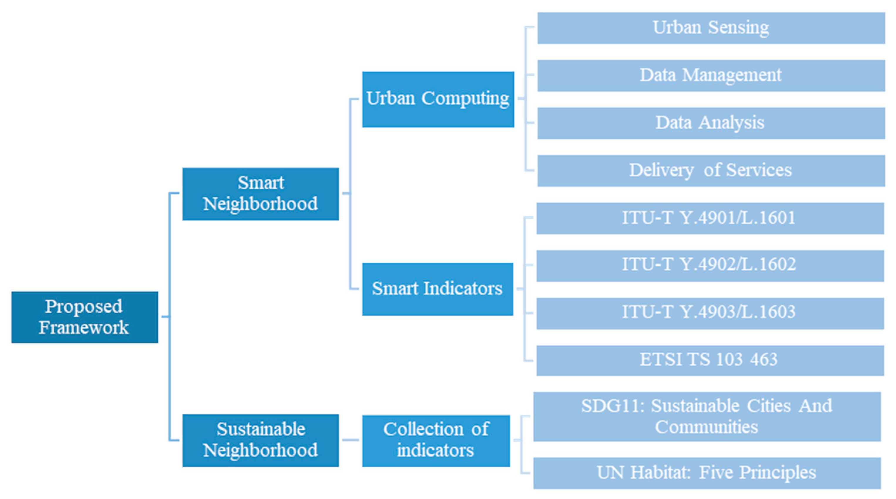
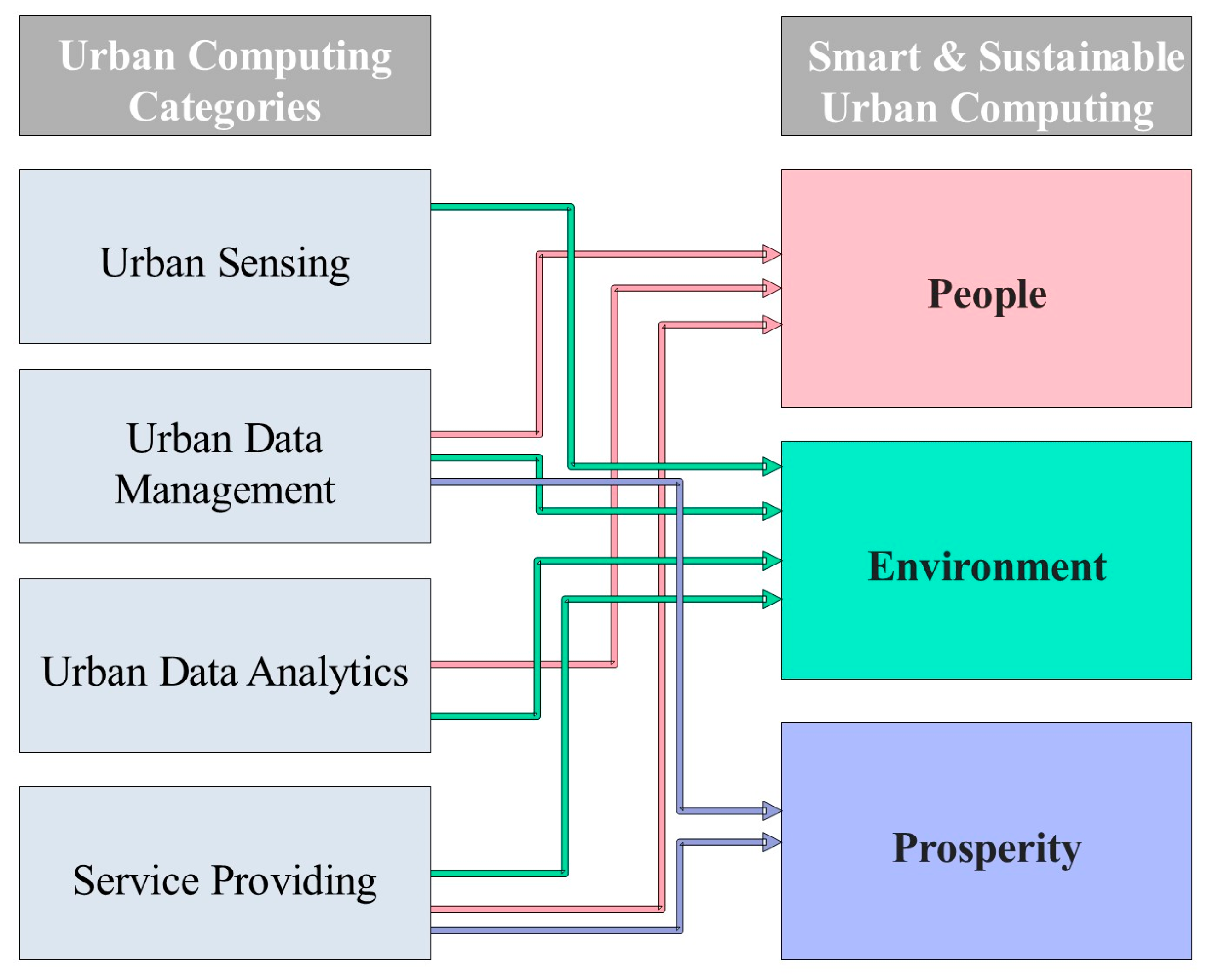
The analysis of this article focuses on the four elements of urban computing: urban sensing, data management, data analytics, and delivery of services. The concept of urban computing will be used as a structured procedure to implement smart aspects to transform neighborhoods into smart neighborhoods, and an assessment of sustainability by using sustainable indicators to measure social, economic, and environmental aspects of a neighborhood. This paper will also explore how to reflect this on current Saudi neighborhoods by studying literature reviews and a case study. The main objectives of this article are to:
  • Investigate the sustainability standards and smart indicators to be used in smart sustainable neighborhoods;
  • Develop a smart and sustainable urban computing framework for neighborhoods;
  • Assess Alkhaledia district, Jizan, as a case study, using the proposed framework.

2. Review of the Literature

2.1. Smart Neighborhood

A new development paradigm combines urban sustainability with smartness, emphasizing the significance of taking both issues into account simultaneously [14]. It was developed in response to the criticism of smart urban strategies that conflict with sustainability, as well as an effort to address the needs of today’s highly digitalized cities in a more comprehensive way than the conventional concept of sustainability allows, and that could be implemented on a neighborhood level [15]. The sustainable development goals (SDGs) are relevant to this research because smart city solutions are expected to play a key role in supporting cities and communities in reaching these goals by aiding stakeholders in controlling and measuring progress toward the SDGs using widely accepted indicators. Recently, attention has focused on how smart solutions can help elevate the quality of life and enhance sustainability of neighborhoods [4].

2.2. Sustainable Neighborhoods

In Saudi Arabia, specifically, achieving sustainability is a challenging task. There are many impediments to overcome to attain sustainability goals [16]. Despite these challenges, the Saudi Arabian government aspires to make the country one of the most sustainable in the region and to set it as an inspiring example for other nations. Existing conditions must be reviewed at several scales, including regions, cities, districts, neighborhoods, and buildings, to attain sustainability. The neighborhood is the city’s smallest planning unit, which contains a variety of elements, such as houses, streets, people, open spaces, and so on [17]. Therefore, achieving a smart and sustainable neighborhood is a good start to attain sustainability for life quality and well-being.
To address current urbanization issues, such as population increase, urban sprawl, poverty, inequality, pollution, overcrowding, urban biodiversity, urban mobility, and energy, the UN-Habitat (the United Nations Human Settlements Program for human settlements and sustainable urban development) assists nations in developing urban planning concepts and systems. The proposed plan is based on five principles that encourage compactness, integration, and connectedness, which are three essential attributes of sustainable communities [18]. The five guiding principles are population concentration, mixed-use development, social variety, adequate street space, and limited land-use specialization. These principles are the prime focus of assessing the sustainability of the Alkhaledia district and providing possible solutions, if any, for the missing factors.

2.3. Smart and Sustainable Indicators for Neighborhoods and Communities

The International Telecommunication Union’s (ITU) definition of “smart sustainable cities” is divided into two parts: the first describes a city’s smart characteristics, while the second describes urban sustainability [19]. The use of information and communication technologies (ICTs) to improve quality of life, the efficiency of urban operations, and competitiveness, for instance, are examples of innovations that are associated with smart city characteristics. These innovations aim to improve the quality of life, efficiency of urban activities and services, and citizen involvement. Moreover, a city’s sustainable characteristics are those that guarantee that it fulfills the economic, social, environmental, and cultural needs of both present and future generations [15]. Therefore, the proposed framework integrates smart indicators for the development of smart neighborhoods, combined with some sustainable indicators for the environmental, economic, and cultural aspects of a sustainable neighborhood with the focus on urban computing and its strategies as the inspiration for a clearer and more strategic framework for smart and sustainable neighborhoods or cities.

3. Materials and Methods

This paper focuses on connecting and integrating the smart indicators and the sustainable indicators of neighborhoods and communities, then molding them to fit urban computing strategies. Thereby, creating an urban computing framework applied to the local context of Saudi Arabia. This is mainly achieved by collecting various indicators that are smart or sustainable and fitting them into the four categories of urban computing which are urban sensing, data management, data analysis, and delivery of services. By making urban computing the overall umbrella of smart and sustainable indicators with also the ISO, ITU, and SDGs indicators, the proposed framework was constructed (Figure 1).

3.1. Developing Urban Computing Framework for the Local Context

Urban computing is a concept used in this project to develop a framework by including smart and sustainable indicators and standards, with the inspiration of urban computing strategies to create a strategic local context framework. This helps achieve smart and sustainable neighborhoods, communities, and cities. Urban computing in this context is used as an overall umbrella to support indicators to become more strategic and it shows how, with the support of urban computing strategies, we can perform successful development of smart and sustainable neighborhoods.
Urban computing is used as a base support for this framework, to formulate a strong strategy for the development of smart and sustainable neighborhoods and communities. One of the main challenges of developing smart neighborhoods is analyzing the urban data, which can be difficult due to their heterogeneity, high complexity, and vast volumes [20]. Therefore, it may cause inefficient use of these data and a lack of relevant processes for solutions. “Urban computing” is the term used to describe the method of developing, integrating, processing, analyzing, and compiling vast quantities of data from various sources to achieve a specific goal, such as addressing issues with sustainability, efficiency, adaptability, equity, and living quality. In addition, the term refers to the use of several sensors, devices, platforms, infrastructures, and networks, as well as the corresponding algorithms, strategies, processes, and protocols in the context of data-driven smart urban sustainability [21]. Urban computing is the basis for the developed framework since it is a comprehensive method of capturing and utilizing the vast amounts of big data generated in cities to improve urban forms, infrastructure, urban environments, and urban services, along with urban operational management and development planning systems.
As a result, it can produce deep insights that can be utilized to make well-informed decisions and can build feedback mechanisms between humans and their activities, as well as between humans and the urban environment [21]. Moreover, a collection of smart standards is incorporated into the developed framework to obtain quantitative and qualitative data involved in the urban computing concept. The chosen standards, including the European Telecommunications Standards Institute (ETSI) standard, are adopted to assess the standardization needs of communities and neighborhoods looking to increase their social, economic, and environmental sustainability through integrating information systems, such as ICTs into their infrastructures and processes. Therefore, the five standards used in this project (ITU-T Y.4901/L.1601, ITU-T Y.4902/L.1602, ITU-T Y.4903/L.1603, ETSI TS 103 463, SDGs) are adopted to integrate a set of indicators into the concept of urban computing and to provide a standardized basis for the framework.

3.2. Developing Indicators for Assessment

For the development of the urban computing framework, the smart indicators that were collected are (ITU-TY.4901/L.1601, 2016) [19]; (ITU-TY.4902/L.1602, 2016) [22]; (ITU-TY.4903/L.1603, 2016) [23]; and (ETSI-TS103-463, 2017) [24]. The sustainable indicators were a collection of SDG 11: sustainable cities and communities [25] and UN-Habitat: five principles [18]. Additionally, we combined all of these mentioned smart and sustainable indicators to construct an assessment tool influenced by the urban computing concept.

3.2.1. Urban Sensing Category

Urban sensing revolves around the distribution of sensors in communities and neighborhoods to reveal information and collect various data on the neighborhood to help enhance services among the neighborhoods. In this article, the urban sensing category is linked to the five standards which are shown in Figure 1. The five standards are matched to the principles of urban sensing in urban computing, which is the relevancy of sensors for serving the citizens and the environment. This applies to placing many sensors that support the IoT and machine learning analysis for the advanced development of supplying data.

3.2.2. Urban Data Management Category

Urban data are an important pillar of any smart community or city since they offer insights into environmental, economic, or social information. These data provide data-driven solutions that benefit everyone. Urban data management processes vast amounts of dynamic urban data from several areas, including traffic, meteorology, human movement, and POIs, using cloud computing platforms, data structures, and retrieval algorithms [26]. This layer is necessary since it aids in data classification and develops special indexing structures and retrieval algorithms for geographical and spatiotemporal data. Additionally, the category of urban data management is linked to the five standards listed in Figure 1. The standards are used for the efficient distribution of data management, which is for the optimal results of data gained from the distributed sensors. Figure 1 shows the linkage between the five standards and the data management of the urban computing concept.

3.2.3. Urban Data Analytics Category

Urban data analysis uses a range of data-mining techniques and machine-learning algorithms to unlock the value of information from data in a variety of fields. Using algorithms, such as clustering, classification, regression, and anomaly detection, this layer changes fundamental data mining and machine-learning approaches to handle spatiotemporal data [26], using the science of big data analytics to process big volumes of data.
Consequently, the five standards indicated in Figure 1 are linked to the category of urban data analytics. These standards are used as a platform to execute data analytics efficiently and to provide the best information. The information extracted from big data analytics can result in unexpected relations between different elements, which can be a big advantage for creating services for people, the environment, and financial prosperity.

3.2.4. Delivery of Services Category

An interface for domain systems to access knowledge from an urban computing application using cloud computing platforms is provided by the service-providing category. Due to the transdisciplinary nature of urban computing, data-driven knowledge must be incorporated into existing domain systems for them to make better judgments. For instance, air quality forecasts from an urban-computing application can be linked to current mobile apps to help people plan their trips, or they can be used by environmental protection authorities’ systems to help them make pollution-control decisions [26]. This is critical to serving citizens’ needs and providing efficient services. Consequently, there is a relationship between the five standards and how they can help optimize the services provided to the people, environment, and prosperity.

4. Results

4.1. Smart and Sustainable Urban Computing Framework

The five selected smart and sustainable indicators were analyzed to create relations to urban computing strategies. For instance, the smart standard (ETSI-TS103-463, 2017) [24] was selected to analyze its four dimensions and choose appropriate indicators for the concept of smart and sustainable neighborhoods. Subsequently, a checklist is created as a start to indicate the relationship of the smart indicators to the urban computing categories (urban sensing, urban data management, urban data analytics, delivery of services), this is to set a starting line on how urban computing concept can be used as a basis for the smart and sustainable neighborhood. Furthermore, the (ITU-TY.4901/L.1601, 2016) [19], (ITU-TY.4902/L.1602, 2016) [22], (ITU-TY.4903/L.1603, 2016) [23], (UN Habitat principles) [18], and (UN, SDG 11: make cities and human settlements inclusive, safe, resilient and sustainable, 2016) [25] relations to urban computing were mapped.
The next stage of the findings Is developing three new dimensions for “smart and sustainable urban computing (SSUCF)” which are people, prosperity, and environment (Figure 2). Following the analysis of those three dimensions and relating them to the urban computing concept, an extensive table was formed as a binary (yes/no) checklist for the SSUCF for neighborhoods. This checklist was developed by picking only 42 appropriate smart standards using their unit and weight. Subsequently, Figure 2 illustrates how the urban computing categories are matched for a clearer understanding of urban computing and the developed framework’s dimensions. This is created by a match work diagram that shows how each category of urban computing matches the dimensions in SSUCF; for instance, the “environment” dimension requires all categories of urban computing, while, “prosperity” requires data management and delivery of services only. This is because the prosperity outlook focuses on how one can manage the data to serve citizens best. The “people” dimension requires data management and analysis to provide certain services to optimize and enhance citizens’ quality of life. Nonetheless, there are some indicators in these dimensions that require all categories of urban computing. Figure 2 illustrates only what the majority of indicators fall under.

SSUCF 3 Dimensions: People, Environment, and Prosperity

The SSUCF consists of various goals, such as connecting a community, having a cleaner environment, enhancing an individual’s health and well-being, building a greener economy, and finally elevating the quality of life. These goals are met by having three focus areas of the framework which are people, environment, and prosperity. Those three dimensions were derived from the standards used in the process of making this framework [(ETSI-TS103-463, 2017) [24], (ITU-TY.4901/L.1601, 2016) [19], (ITU-TY.4902/L.1602, 2016) [22], (ITU-TY.4903/L.1603, 2016) [23], (UN, SDG 11: make cities and human settlements inclusive, safe, resilient and sustainable, 2016) [25]], and these standards influenced the selection of these dimensions for the SSUCF.
The first dimension is “people”. This main indicator is everything related to the individual’s social environment. Its focus is establishing a sense of belonging and social inclusion in neighborhoods, and most importantly the involvement of technology and smart ICTs to optimize the social environment. As seen in Table 1, there are a total of 13 indicators in SSUCF, and its area of focus is “people”. Table 1 shows which urban computing categories are present or not present in each indicator. The next dimension is “environmental”, which accounts for the overall good quality and efficiency of the environment in a neighborhood, in terms of air, water, and energy. As seen in Table 2, 15 indicators contribute to environmental protection in a neighborhood with also the urban computing categories to complement an efficient and smart application of the indicator. The last dimension is “prosperity”, and this dimension helps build a resilient neighborhood criterion, by building a greener economic development. Table 3 shows the 14 indicators that account for the prosperity of the neighborhood. In total, the SSUCF comprises 42 indicators to have an outlook on the social, environmental, and economical areas in the neighborhood.

4.2. Application to Alkhaledia District, Jizan

The SSUCF is analyzed and altered to be tailored to the Alkhaledia district (Figure 3), which resulted in 27 indicators after filtering. This stage of the framework was fixed upon the characteristics and availability of the data in the Alkhaledia district [27]. The people, environment, and prosperity dimensions had specific indicators that are either found or not found in the Alkhaledia district, additionally, some indicators are a must-have in the context of urban computing, sustainability, and smartness, however, they were not found in the Alkhaledia neighborhood. Moreover, since Alkhaledia has some sustainable and smart objectives, some indicators are met, therefore making the urban computing framework easier to implement.

4.2.1. The People Dimension

The “people” dimension is a set of nine indicators that were selected according to their importance to the initial framework and the availability of data. As seen in Table 4, 56% of the indicators of this dimension were not in the Alkhaledia district; this requires the urban computing contribution to enhance these indicators’ existence in Alkhaledia. Moreover, 44% of the indicators were found in the Alkhaledia district, so it may need better enhancement with SSUCF. Furthermore, Figure 4 illustrates some of the indicators on the layout plan of Alkhaledia; this includes the covered indicators in Alkhaledia, such as “availability of parking guidance”, which is found in mixed-use areas of the neighborhood that include stores and other facilities. Figure 4 also shows that indicators, such as “encouraging a healthy lifestyle” are not found, according to Table 4, in the neighborhood. The indicator ensures a healthier lifestyle by having a social area for people connected with green areas.

4.2.2. Environment Dimension

The “environment” dimension encompasses all measures that are related to protecting the environment. Table 5 emphasizes the significance of the environmental indicators that the Alkhaledia district needs, along with indicators for environmentally sensitive matters that the region faces, such as water resources. The table has a set of nine indicators that are either “found” or “not found” in the Alkhaledia neighborhood, and it shows that to some degree, the current construction of Alkhaledia considers environmental concerns: 44% of the indicators were not found in Alkhaledia, while 56% of environmental indicators were (Table 5). This shows that Alkhaledia can easily use SSUCF to enhance the environmental aspect of the district. Moreover, Figure 5 demonstrates the contribution of SSUCF to the Alkhaledia district, illustrating how the environmental dimension provides enhancement of environmental protection.

4.2.3. Prosperity Dimension

The prosperity dimension accounts for the economic development to ensure the prosperity and longevity of the district. This dimension results in the success of building resilient neighborhoods by incorporating the nine indicators in Table 6. These indicators can be the starting point for prosperity, which can later advance to more indicators that ensure prosperity in the district. Furthermore, Table 6 shows the current state of prosperity level in Alkhaledia by having a “yes” or “no” column to indicate whether the indicators are found in the district or not. Thus, the results of the nine indicators indicate that 78% are not covered in Alkhaledia and 22% currently exist in Alkhaledia. Therefore, it highlights the need for using the SSUCF to develop the district into an enhanced neighborhood. Moreover, Figure 6 illustrates how the prosperity dimension can be incorporated into the Alkhaledia neighborhood by having some indicators shown on the layout plan of Alkhaledia.

5. Discussion

This article is mainly concerned with developing a framework based on the idea of urban computing, and the process of developing the framework went through multiple stages of thorough analysis to make the SSUCF. Therefore, the results of each table interpret different meanings and significance. The data on the four smart and sustainable standards, the interpretation of the urban computing concept, and their analysis support the theory that urban computing has great significance in the enhancement of neighborhood quality of life, sustainability, and smartness, as highlighted by Keshavarzi et al. [4] and Alshuwaikhat et al. [6]. A few of the chosen indicators fell under all the urban computing categories, while others had only certain urban computing categories that can relate to the indicator. Therefore, this proves that urban computing can be used as a structured format for the development of sustainability and smartness.
The initial framework for SSUCF contains the three main chosen dimensions of “people”, “environment”, and “prosperity”, which were deduced from the filtered smart and sustainable standards while considering the local context and alignment with the Saudi 2030 vision. The table has a total of 42 indicators that relate to the environmental, social, and economic aspects that a neighborhood should focus on, to ensure the success of the framework. Furthermore, this table demonstrates the correlation between urban computing and the three chosen dimensions, which also illustrates how critical the sequence of sensors, data management, data analysis, and services are (in that order) for the indicators to be effective and efficient. Each indicator has its essential urban computing layer, which is analyzed by various literature reviews and other sustainable standards. Abusaada and Elshater [28] developed a similar framework of urban design for smart sustainable cities. However, their framework focused on two dimensions—urban economy and placemaking—which did not explicitly consider the environmental dimension.
Table 4, Table 5 and Table 6 show, as stated in Section 3.2.1, how sensors are the first detectors for data that help us attain the information to procure sustainable and efficient services [29]. This shows how important attaining data by sensors is in the urban sensing category, where 62% of the 42 indicators needed the sensory system. Moreover, the data management category showcases the importance of data being neatly organized by an indexing structure as it integrates both spatiotemporal and textual information for efficient data analytics. This finding shows that the category is critical to the achievement of the goal of the framework by having 90% of the 42 indicators including urban data management.
Urban data analytics is the use of big data analytics to analyze relations of data for the success of urban computing in neighborhoods [30,31,32,33,34], and 78% of the indicators may need big data analysis for the efficient use of indicators. Finally, 90% of the indicators are relevant to the delivery of services category. This shows that as part of having an inclusive and higher quality of life neighborhood, we must focus on the needs of residents and how our technology and smart gadgets can be of help for solving problems efficiently. The SSUCF has multiple limitations, some of which are how resources are limited and how ready decision-makers are for a smart-driven neighborhood. This is in terms of awareness of developers and the availability of resources for the technical success of the neighborhood projects.
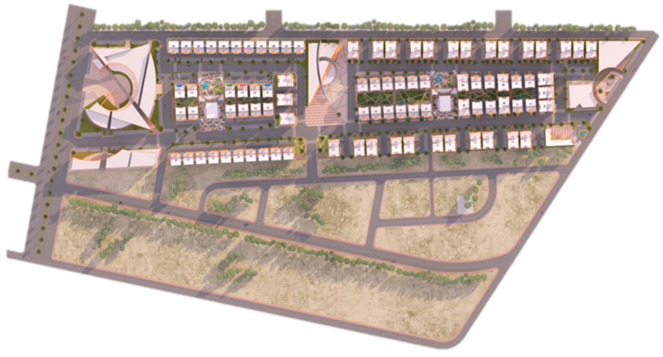
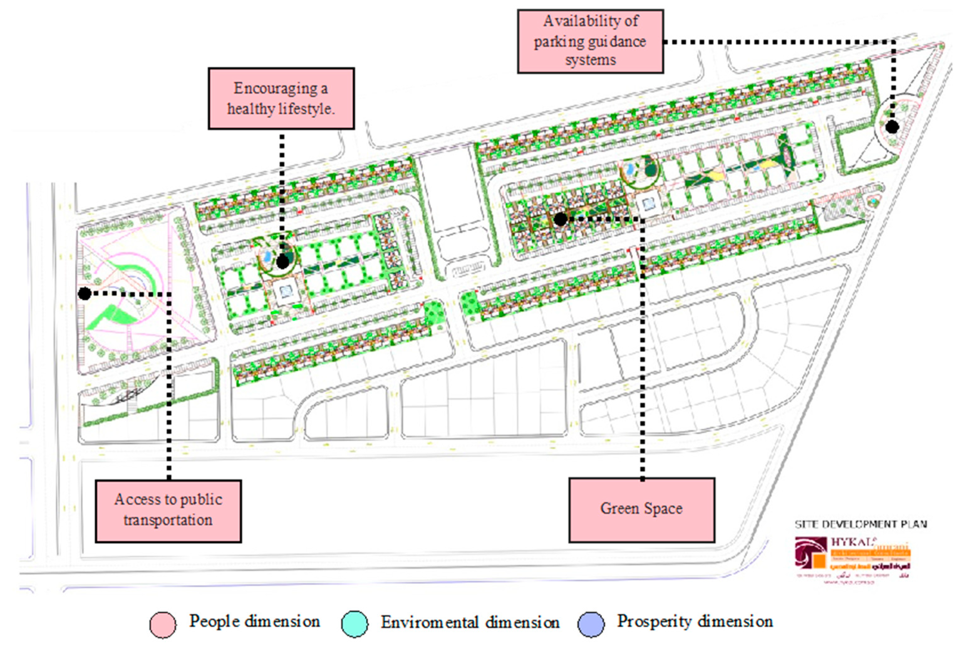
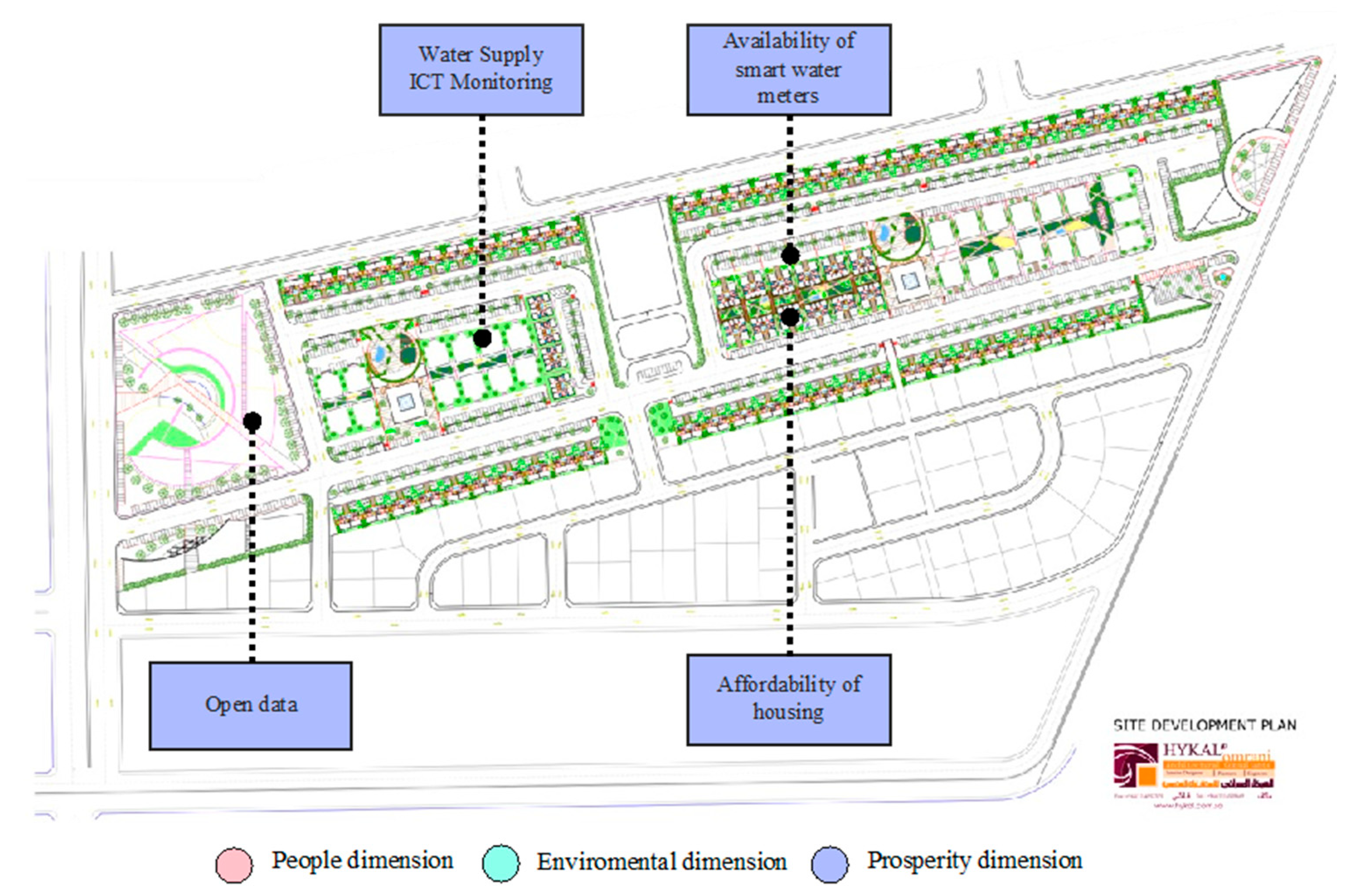
Section 4.2 shows the findings of the case study, in the Alkhaledia district, Jizan. The section presents the tailored indicators for Alkhaledia from the developed framework, since the Alkhaledia project has sustainable and smart objectives, some indicators are met, however, they need some alteration to fit into the SSUCF. This was developed by analyzing indicators by the criteria of “must have”, “should have”, and “nice to have”, and relying on the project characteristics mentioned in the literature review case study section, as to whether these indicators are found or not, and if found, it could be enhanced into the structured format of urban computing categories. If an indicator is not found and if it is a must-have for a smart sustainable neighborhood, then it will undergo the thorough process of urban computing categories to form a successful indicator that serves its residents, economy, and environment. Although this filtering of indicators yields 27 indicators, it is partly a result of the lack of data regarding the Alkhaledia districts and their policies. Therefore, the limitation of resources and data creates a constrained development of indicators for enhanced development of the SSUCF.
Another set of challenges regarding the use of data in this framework are the data-specific issues, which can fall under data acquisition, privacy, and security. Since data and computing together form the critical component of urban computing, it must be executed efficiently by considering all of its components. The most crucial factor is data privacy and security since smart applications not only gather a variety of information from people and their social networks that are sensitive to privacy [35,36], but also operate facilities and have an impact on people’s lives. Furthermore, data acquisition is another challenge, as the collection of data from sensors creates a large volume of information that might be difficult to analyze with redundant data.
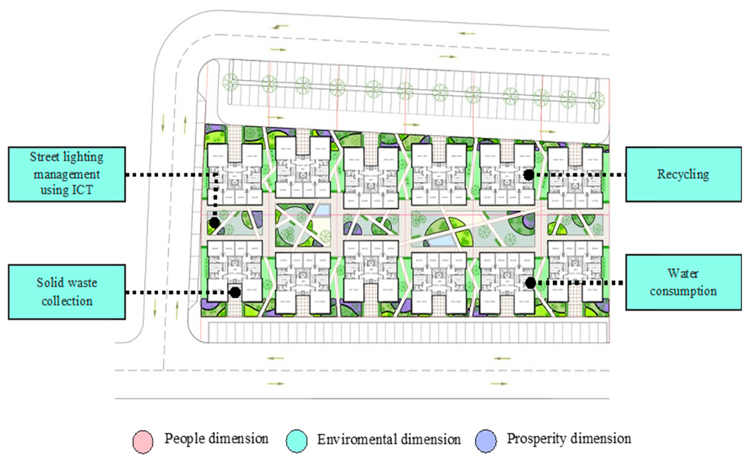
The SSUCF focuses on social, environmental, and economic factors. The “people” dimension relates to the socially important indicators that ensure a better quality of life. Table 4 shows the first three indicators of the people dimension in SSUCF. Furthermore, this dimension accounts for the residents’ related data and what we can do when we acquire these data to better serve the people which in turn demands a security system that ensures the protection of the community’s data, hence the cybersecurity indicator shown in Table 4. As mentioned in the literature review, there are precautions to ensure data security, and that is important, as a technology-based system is more prone to cyber risks, therefore, addressing these sensitive topics is critical to ensure better performance of the smart and sustainable neighborhood. These indicators are enhanced into a comprehensive indicator by plugging in the urban computing categories. The “environmental” dimension, which was missing in Abusaada and Elshater’s framework [28] includes a set of indicators that promotes environmental sustainability. Though energy and water consumption and recycling indicators are covered in Alkhaledia, carbon emissions are not covered. Carbon emissions are regarded as one of the important environmental indicators since they are related to climate change [37,38,39].
The final dimension of this framework is “prosperity”, which encompasses the economical aspect of the neighborhood that secures longevity and prosperity in the district. A neighborhood built with this framework can ensure the complete comfort of residents to live a sustainable and smart life. These objectives ensure the availability of services to enhance the quality of life in the Alkhaledia district. Table 6 shows some of the indicators that are found in the “prosperity” dimension, chosen by analyzing the report documents available from the Alkhaledia district and selecting the appropriate indicators from the selected standards to support the neighborhood’s prosperity. Consequently, having urban computing layers enhances the production of this dimension, with the help of a literature review to understand how technology can elevate the prosperity of the neighborhood. For instance, affordable housing is a critical consideration when developing this framework, and since the Alkhaledia district has the design objective of constructing an affordable housing residential area, urban computing can be plugged into this neighborhood and framework.

6. Conclusions

This article aims to establish neighborhoods that support a healthy environment, a strong community, and growing economic value by having a smart and sustainable neighborhood framework, facilitated using intelligent concepts and technologies, such as urban computing. Creating smart sustainable neighborhoods is crucial to addressing the ever-changing demands of Saudi citizens who live in urban areas. A comprehensive and integrated approach to a neighborhood’s social, economic, and environmental values is lacking in Saudi neighborhoods. As a result, it creates a variety of negative effects, including poor environmental protection, poor quality of life, and insufficient services and amenities. More importantly, Saudi Vision 2030 has three main areas of focus: “vibrant society”, “thriving economy”, and “ambitious nation”, which emphasize the need for neighborhoods that are more environmentally conscious and has smart technologies to support sustainability and its measures. To build a brighter future for the country and its people, the 2030 Vision is used as the foundation for the project’s proposed framework and acts as its primary goal. Furthermore, an application of this framework was created in the Alkhaledia district, for further advancement of the framework.
Two key elements are crucial to the creation of this framework: the concept of urban computing, which is the identification and analysis of the four subcategories of urban computing: urban sensing, urban data management, urban data analytics, and the delivery of services; and selecting the appropriate indications from the four sets of standards which are ITU, ETSI, and SDG 11 for sustainable cities and communities. These two elements influenced how the SSUCF is developed. Consequently, a tailored framework is developed to be implemented in the Alkhaledia district to enhance the effectiveness of this framework. This was accomplished by having filtered indicators that aim to improve the Alkhaledia district. This framework development shows that urban computing may be used as a basis for support, together with smart and sustainable standards, to establish a framework for a neighborhood that is both smart and sustainable. Additionally, this framework can be used in other Saudi neighborhoods to improve the quality of life, environmental protection, and economic values when accommodating the relevant data.
Furthermore, urban computing involves more than just smart technologies, it also considers how to gather the relevant data that will help us find solutions, manage that data, and link technology with local problems to find solutions. This serves the residents, helps the economy, and supports the environment. Since many Saudi neighborhoods do not use smart technologies to assist sustainable growth, this framework supports tackling this gap. Additionally, this analysis shows that urban computing could serve as a constructive and organized format for the use of smart technologies to serve the sustainability of the community, economy, and environment. These results were found by a matrix table checking how many smart or sustainable indicators can fall under urban computing categories.
The final finding is the application of the SSUCF in the Alkhaledia district, Jizan. This framework is tailored to the context of Jizan and its available data; therefore, to achieve these smart and sustainable goals, a variety of strategies must be used, along with advanced technology solutions, research, inventions, and deployment found in this framework. Various indicators were chosen to improve the Alkhaledia neighborhood and build a more comprehensive and inclusive district. This was achieved by first studying the current state of Alkhaledia and having indicators enhance the present elements of Alkhaledia, and constructing it if it does not yet exist.
Moreover, this framework has limitations that are related to data collection, data privacy, data security, and data analysis. Even though data collection is made easy with sensors, it could create challenges since it might collect redundant and high-volume data. Furthermore, data privacy and security are vital concerns, since all relevant data of citizens are collected to create an enhanced quality of life. Furthermore, other limitations of this article include the filtration of indicators that resulted from a lack of data regarding Jizan policies and the neighborhood’s readiness for a technology-based infrastructure and development. Additionally, Alkhaledia has different sectors to focus on, and this demands integration between stakeholders and investors by involving all personal data to make decision-making more cohesive for smart and sustainable neighborhoods.
Future studies might explore enhancing the indicators concerning residents’ quality of life—that is, more comprehensive indicators should be considered and extended to address more neighborhood sectors, subject to the availability of resources and data. This article is important for building a smart and sustainable neighborhood, especially in the Saudi region where it is most needed. Furthermore, despite this development of the framework being tailored to the Alkhaledia district, it can be implemented in other neighborhoods and regions since it has room for further enhancement for a more integrated, smart, and sustainable neighborhood framework. Nonetheless, with the aid of smart technology, the SSUCF can foster communities that are inclusive in all social, economic, and environmental aspects. Future studies can explore how the concepts of Kate Raworth’s “doughnut economy” or “circular economy” can be integrated into the development of smart sustainable indicators [40,41]. These indicators can create not only a guideline heuristic for different cities to start to think about sustainable initiatives, but might also address sustainable macro perspectives.

Author Contributions

Conceptualization, H.M.A. and L.B.; methodology, H.M.A., Y.A.A. and L.B.; formal analysis, L.B.; writing—original draft preparation, Y.A.A. and L.B.; writing—review and editing, H.M.A., Y.A.A. and L.B.; supervision, H.M.A. All authors have read and agreed to the published version of the manuscript.

Funding

This research received no external funding.

Institutional Review Board Statement

Not applicable.

Data Availability Statement

The data presented in this study are available in the article.

Acknowledgments

The authors acknowledge the support of the Interdisciplinary Research Center for Smart Mobility & Logistics (under project number IN-ML2200), King Fahd University of Petroleum and Minerals, and Yanbu Industrial College, Saudi Arabia. The authors are also grateful to Salman Abdullah Bin Saedan Real Estate Group for providing the Jizan Master Plan Development documents.

Conflicts of Interest

The authors declare no conflict of interest.

References

  1. Drobniak, A. The urban resilience–economic perspective. J. Econ. Manag. 2012, 10, 5–20. [Google Scholar]
  2. United Nations. From Department of Economic and Social Affairs. Available online: https://www.un.org/development/desa/en/news/population/2018-revision-of-world-urbanization-prospects.html (accessed on 16 May 2018).
  3. Nakano, S.; Washizu, A. Will smart cities enhance the social capital of residents? The importance of smart neighborhood management. Cities 2021, 115, 103244. [Google Scholar] [CrossRef]
  4. Keshavarzi, G.; Yildirim, Y.; Arefi, M. Does scale matter? An overview of the “smart cities” literature. Sustain. Cities Soc. 2021, 74, 103151. [Google Scholar] [CrossRef]
  5. INEA. Smart Cities & Communities. Available online: https://ec.europa.eu/inea/en/horizon-2020/smart-cities-communities (accessed on 15 December 2022).
  6. Alshuwaikhat, H.M.; Aina, Y.A.; Binsaedan, L. Analysis of the implementation of urban computing in smart cities: A framework for the transformation of Saudi cities. Heliyon 2022, 8, e11138. [Google Scholar] [CrossRef] [PubMed]
  7. Torres-Ruiz, M.J.; Lytras, M.D. Urban Computing and Smart Cities Applications for the Knowledge Society. Int. J. Knowl. Soc. Res. 2016, 7, 113–119. [Google Scholar] [CrossRef] [Green Version]
  8. Shi, W.; Goodchild, M.; Batty, M.; Kwan, M.; Zhang, A. Introduction to urban informatics. In Urban Informatics; Shi, W., Goodchild, M., Batty, M., Kwan, M., Zhang, A., Eds.; Springer: Berlin/Heidelberg, Germany, 2021; pp. 1–7. [Google Scholar]
  9. Nasser, G.M.; Alghamdi, M. Social sustainability in the built environment of Riyadh city (Case study: Al-Waha residential neighborhood). Emir. J. Eng. Res. 2022, 27, 5. [Google Scholar]
  10. Ledraa, T.; Aldegheishem, A. What Matters Most for Neighborhood Greenspace Usability and Satisfaction in Riyadh: Size or Distance to Home? Sustainability 2022, 14, 6216. [Google Scholar] [CrossRef]
  11. Bay, M.A.; Alnaim, M.M.; Albaqawy, G.A.; Noaime, E. The Heritage Jewel of Saudi Arabia: A Descriptive Analysis of the Heritage Management and Development Activities in the At-Turaif District in Ad-Dir’iyah, a World Heritage Site (WHS). Sustainability 2022, 14, 10718. [Google Scholar] [CrossRef]
  12. Alnaim, M.M.; Noaime, E. Typological Transformation of Individual Housing in Hail City, Saudi Arabia: Between Functional Needs, Socio-Cultural, and Build Polices Concerns. Sustainability 2022, 14, 6704. [Google Scholar] [CrossRef]
  13. Alshuwaikhat, H.M.; Adenle, Y.A.; Almuhaidib, T. A lifecycle-based smart sustainable city strategic framework for realizing smart and sustainability initiatives in Riyadh City. Sustainability 2022, 14, 824. [Google Scholar] [CrossRef]
  14. Aina, Y.A. Achieving smart sustainable cities with GeoICT support: The Saudi evolving smart cities. Cities 2017, 71, 49–58. [Google Scholar] [CrossRef]
  15. Aapo Huovilaa, P.B. Comparative analysis of standardized indicators for Smart sustainable cities: What indicators and standards to use and when. Cities Int. J. Urban Policy Plan. 2019, 89, 141–153. [Google Scholar] [CrossRef]
  16. Aina, Y.A.; Wafer, A.; Ahmed, F.; Alshuwaikhat, H.M. Top-down sustainable urban development? Urban governance transformation in Saudi Arabia. Cities 2019, 90, 272–281. [Google Scholar] [CrossRef]
  17. Karban, A.S. Developing a Framework for Neighborhood-Level Urban Sustainability Assessment in Saudi Arabia. Master’s Thesis, Umm Al-Qura University, Mecca, Saudi Arabia, 2014. [Google Scholar]
  18. UN-Habitat. A new Strategy of Sustainable Neighbourhood Planning: Five Principles. Available online: https://unhabitat.org/sites/default/files/download-manager-files/A%20New%20Strategy%20of%20Sustainable%20Neighbourhood%20Planning%20Five%20principles.pdf (accessed on 15 December 2022).
  19. ITU-TY.4901/L.1601; Key Performance Indicators Related to the Use of Information and Communication Technology in Smart Sustainable Cities. International Telecommunication Union: Geneva, Switzerland, 2016.
  20. Zheng, Y.; Wu, W.; Chen, Y.; Qu, H.; Ni, L.M. Visual Analytics in Urban Computing: An Overview. IEEE Xplore 2016, 2, 276–296. [Google Scholar] [CrossRef]
  21. Bibri, S.E. Data-Driven Smart Sustainable Cities of the Future: Urban Computing and Intelligence for Strategic, Short-Term, and Joined-Up Planning; Springer: Berlin/Heidelberg, Germany, 2021. [Google Scholar]
  22. ITU-TY.4902/L.1602; Key Performance Indicators Related to the Sustainability Impacts of Information and Communication Technology in Smart Sustainable Cities. International Telecommunications Union: Geneva, Switzerland, 2016.
  23. ITU-TY.4903/L.1603; Key Performance Indicators for Smart Evaluation and Assessment Sustainable Cities to Assess the Achievement of Sustainable Development Goals. International Telecommunications Union: Geneva, Switzerland, 2016.
  24. ETSI-TS103-463; Access, Terminals, Transmission and Multiplexing (ATTM); Key Performance Indicators for Sustainable Digital Multiservice Cities. ETSI TS: Sophia Antipolis, France, 2017.
  25. UN. Sustainable Development Goal 11: Make Cities and Human Settlements Inclusive, Safe, Resilient and Sustainable; United Nations: Lake Success, NY, USA, 2016. [Google Scholar]
  26. Zheng, Y. Urban Computing; MIT Press: Cambridge, MA, USA, 2019. [Google Scholar]
  27. Salman Abdullah BinSaedan Real Estate Group. Alkhaledia Master Plan Development; Salman Abdullah BinSaedan Real Estate Group: Riyadh, Saudi Arabia, 2017. [Google Scholar]
  28. Abusaada, H.; Elshater, A. Competitiveness, distinctiveness and singularity in urban design: A systematic review and framework for smart cities. Sustain. Cities Soc. 2021, 68, 102782. [Google Scholar] [CrossRef]
  29. Behr Tech. Behr Tech Top IoT Sensor Types. Available online: https://behrtech.com/blog/top-10-iot-sensor-types/ (accessed on 5 December 2022).
  30. Zheng, Y. Urban Computing: Concepts, Methodologies, and Applications. ACM Trans. Intell. Syst. Technol. 2014, 11, 55. [Google Scholar]
  31. Zheng, Y. Urban Computing: Enabling Urban Intelligence with Big Data; The MIT Press: Cambridge, MA, USA, 2017; pp. 1–3. [Google Scholar]
  32. Miltiadis, D.; Lytras, A.V.-R. IEEE Access Special Section Editorial: Urban Computing and Well-Being in Smart Cities: Services, Applications, Policymaking Considerations. IEEE Access 2020, 8, 72340–72346. [Google Scholar]
  33. Pérez-Chacón, R.; Luna-Romera, J.M.; Troncoso, A.; Martínez-Álvarez, F.; Riquelme, J.C. Big Data Analytics for Discovering Electricity Consumption Patterns in Smart Cities. Energies 2018, 11, 683. [Google Scholar] [CrossRef] [Green Version]
  34. Pettit, A.B.C. Planning support systems for smart cities. City Cult. Soc. 2018, 12, 13–24. [Google Scholar] [CrossRef]
  35. Belli, A.C.L. IoT-Enabled Smart Sustainable Cities: Challenges and Approaches. Smart Cities 2020, 3, 52. [Google Scholar] [CrossRef]
  36. Khatoun, S.Z.R. Cybersecurity and Privacy Solutions in Smart Cities. IEEE Commun. Mag. 2017, 55, 51–59. [Google Scholar] [CrossRef]
  37. Quijano, A.; Hernández, J.L.; Nouaille, P.; Virtanen, M.; Sánchez-Sarachu, B.; Pardo-Bosch, F.; Knieilng, J. Towards sustainable and smart cities: Replicable and KPI-driven evaluation framework. Buildings 2022, 12, 233. [Google Scholar] [CrossRef]
  38. Kaginalkar, A.; Kumar, S.; Gargava, P.; Niyogi, D. Review of urban computing in air quality management as smart city service: An integrated IoT, AI, and cloud technology perspective. Urban Clim. 2021, 39, 100972. [Google Scholar] [CrossRef]
  39. Hancke, G.P.; de Carvalho e Silva, B.; Hancke, G.P., Jr. The Role of Advanced Sensing in Smart Cities. Sensors 2012, 13, 393–425. [Google Scholar] [CrossRef] [Green Version]
  40. Raworth, K. A Doughnut for the Anthropocene: Humanity’s compass in the 21st century. Lancet Planet. Health 2017, 1, e48–e49. [Google Scholar] [CrossRef]
  41. Almulhim, A.I.; Abubakar, I.R. Understanding public environmental awareness and attitudes toward circular economy transition in Saudi Arabia. Sustainability 2021, 13, 10157. [Google Scholar] [CrossRef]
Figure 1. The chart of the proposed framework.
Sustainability 15 04057 g001
Figure 2. Framework dimensions and their relation to urban computing categories.
Sustainability 15 04057 g002
Figure 3. Rendered layout plan of Alkhaledia (Source: Salman Abdullah Bin Saedan Real Estate Group [27]).
Sustainability 15 04057 g003
Figure 4. People dimension of the SSUCF on the layout plan (Source: Adapted from Salman Abdullah Bin Saedan Real Estate Group [27]).
Sustainability 15 04057 g004
Figure 5. Environmental dimension of SSUCF on the residential layout plan (Source: Adapted from Salman Abdullah Bin Saedan Real Estate Group [27]).
Sustainability 15 04057 g005
Figure 6. Prosperity dimension SSUCF on the residential layout plan (Source: Adapted from Salman Abdullah Bin Saedan Real Estate Group [27]).
Sustainability 15 04057 g006
Table 1. SSUCF people dimension.
Smart & Sustainable Urban Computing FrameworkUrban Computing Layers
Urban Sensing Urban Data ManagementUrban Data AnalyticsDelivery of ServicesYes/No
Main IndicatorsPeopleEncouraging a healthy lifestyle
Cybersecurity
Data privacy
Access to public transportation
Diversity of housing types
Green space
Use of an e-learning system
Sharing of medical resources and information among hospitals, pharmacies, and other healthcare providers
Availability of ICT-based safety systems
Availability of online neighborhood information and feedback mechanisms
Availability of parking guidance systems
Electricity consumption
Information security and privacy protection
Table 2. SSUCF environmental dimension.
Smart & Sustainable Urban Computing FrameworkUrban Computing Layers
Urban SensingUrban Data ManagementUrban Data AnalyticsDelivery of ServicesYes/No
Main IndicatorsEnvironmentDomestic material consumption
Local food production
Energy consumption/demand: Annual final energy consumption
CO2 emissions
Renewable energy generated within the neighborhood
Water consumption
Grey and rainwater use
Air quality index
Recycling rate
Sewage system management using ICT
Street lighting management using ICT
Application of ICT-based noise monitoring
Availability of smart water meters
Energy saving in households
Solid waste collection
Table 3. SSUCF prosperity dimension.
Smart & Sustainable Urban Computing FrameworkUrban Computing Layers
Urban SensingUrban Data ManagementUrban Data AnalyticsDelivery of ServicesYes/No
Main IndicatorsProsperityInnovative hubs
Open data
Accessibility of open data sets
Affordability of housing
Application of computing platforms
Companies providing e-services
Improvement of industry productivity through ICT
Investments in ICT innovation
Availability of smart water meters
Availability of smart electricity meters
Road traffic efficiency
Water supply ICT monitoring
Traffic monitoring
ICT Noise monitoring
Table 4. Alkhaledia—people dimension of SSUCF.
Smart and Sustainable Urban Computing: Alkhaledia District, Jizan
IndicatorCoverageExplanation
Main IndicatorsPeopleEncouraging a healthy lifestyleNoAlthough there is consideration of vegetation which conveys a healthy lifestyle, there are no other metrics to ensure a healthy lifestyle
CybersecurityNoThere are no technical considerations for cybersecurity
Data privacyNoThere are no technical considerations for data privacy
Access to public transportationNoThe design has no consideration to connect residents for public transport and there is no information on the access to public transportation either
Diversity of housing typesYesZone (3): contains three types of apartments of two or three bedrooms, penthouses, and villas
Green spaceYesThe design of the district considered green corridors, green spaces, green plazas, and open green parks
Availability of parking guidance systemsYesConnected to wi-fi networks to inform parking spot searching via smartphone
Electricity consumptionYesSensors are installed throughout the neighborhood for data collection on electricity consumption
Information security and privacy protectionNoThere is no information on how privacy is protected
Table 5. Alkhaledia—environmental dimension of SSUCF.
Smart and Sustainable Urban Computing: Alkhaledia District, Jizan
IndicatorCoverageExplanation
Main IndicatorsEnvironmentalDomestic material consumptionNoNo service acts upon domestic material consumption
Energy consumption/demand: annual final energy consumptionYesApplying suitable energy conservation measures
Carbon emissionsNoNo applicable measures for the measurements of carbon emission
Water consumptionYesMultiple water management strategies to measure water consumption
Air quality indexNoThere is no appropriate measure of air quality
Recycling rateYesMinimal measures of recycling waste
Sewage system management using ICTNoLacks a comprehensive sewage management system by using smart technology
Street lighting management using ICTYesAvailable smart street lighting using sensors and ICT technology
Solid waste collectionYesAvailable smart waste management for efficient waste collection
Table 6. Alkhaledia—prosperity dimension of SSUCF.
Smart and Sustainable Urban Computing: Alkhaledia District, Jizan
IndicatorCoverageExplanation
Main IndicatorsProsperityOpen dataNoLacks an open data platform
Affordability of housingYesZone (3): contains affordable types of apartments of two or three bedrooms, penthouses, and villas
Improvement of industry productivity through ICTNoAlthough limited ICT technologies are used throughout the district, there is no further advancement of ICT industry productivity
Availability of smart water metersYesThe district installs meters, transmitters, and sensors for the success of smart water meters
Availability of smart electricity metersNoThere are no available meters, transmitters, and sensors for smart electricity metering
Road traffic efficiencyNoLacks road traffic efficiency
Water supply ICT monitoringNoAlthough limited ICT technologies are used throughout the district there is no further advancement of ICT water supply monitoring
Traffic monitoringNoLacks the focus on traffic monitoring
ICT noise monitoringNoLacks an ICT noise monitoring sensory system
Disclaimer/Publisher’s Note: The statements, opinions and data contained in all publications are solely those of the individual author(s) and contributor(s) and not of MDPI and/or the editor(s). MDPI and/or the editor(s) disclaim responsibility for any injury to people or property resulting from any ideas, methods, instructions or products referred to in the content.

