
An RSU Deployment Scheme for Vehicle-Infrastructure Cooperated Autonomous Driving

Abstract
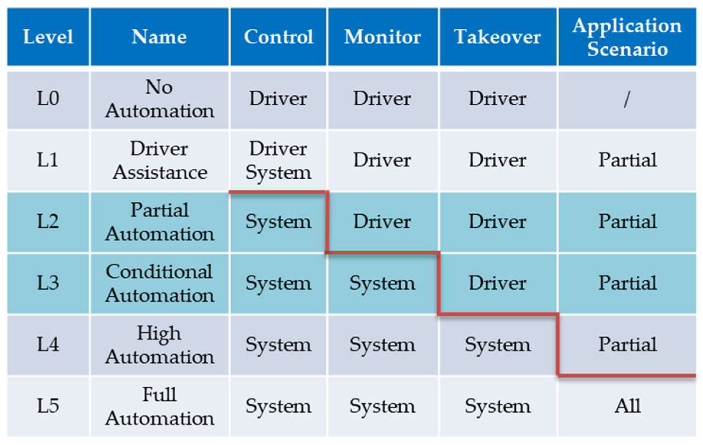
:1. Introduction
2. Materials and Methods
2.1. Road Network Model
2.2. Time Threshold
2.3. Objectives
2.4. Method
- (1)
- The selection of the global best position
- (2)
- Mutation operator
- (3)
- The updated policy of the external archive
- (4)
- The MOQPSO installation process steps
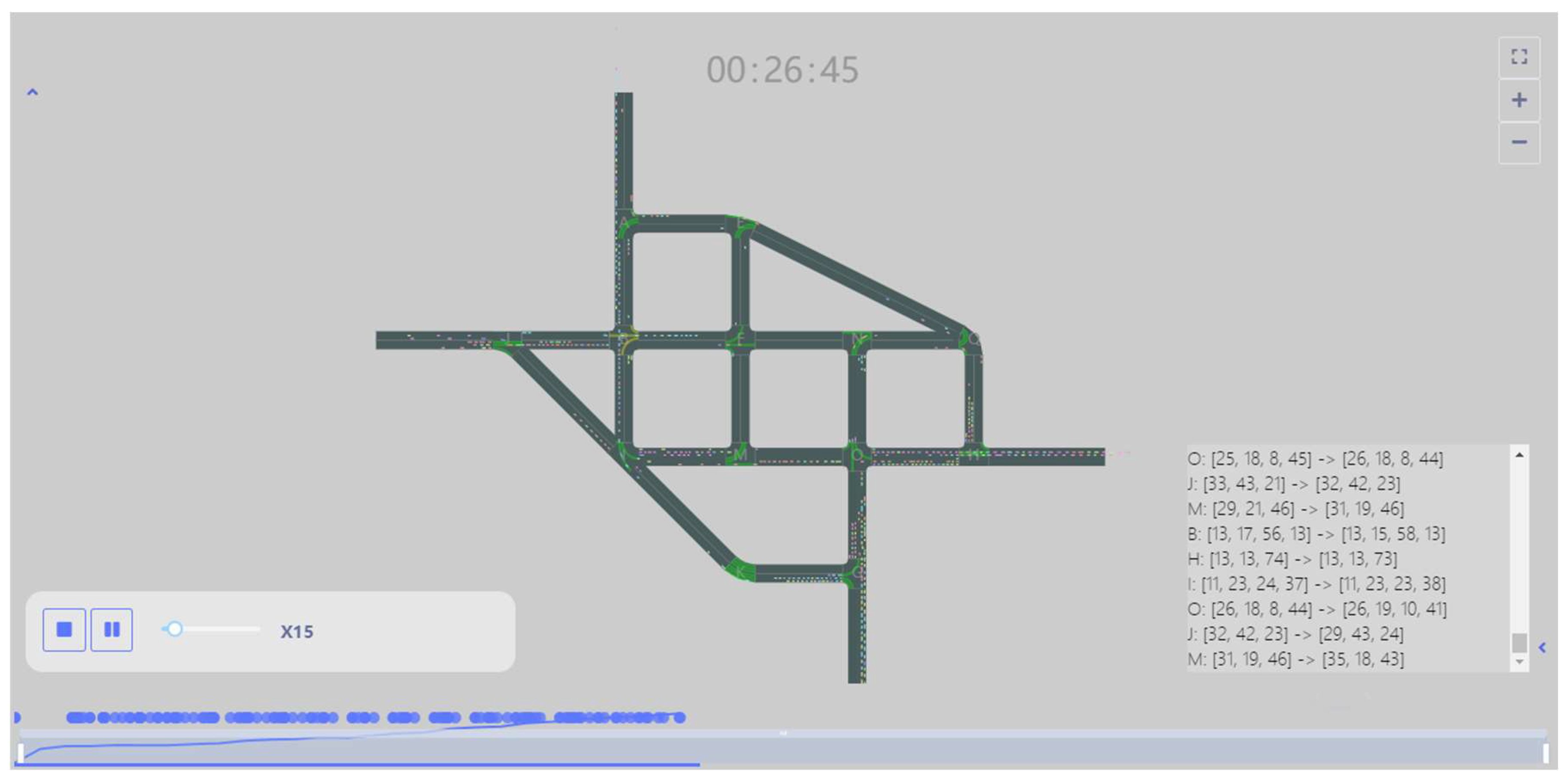
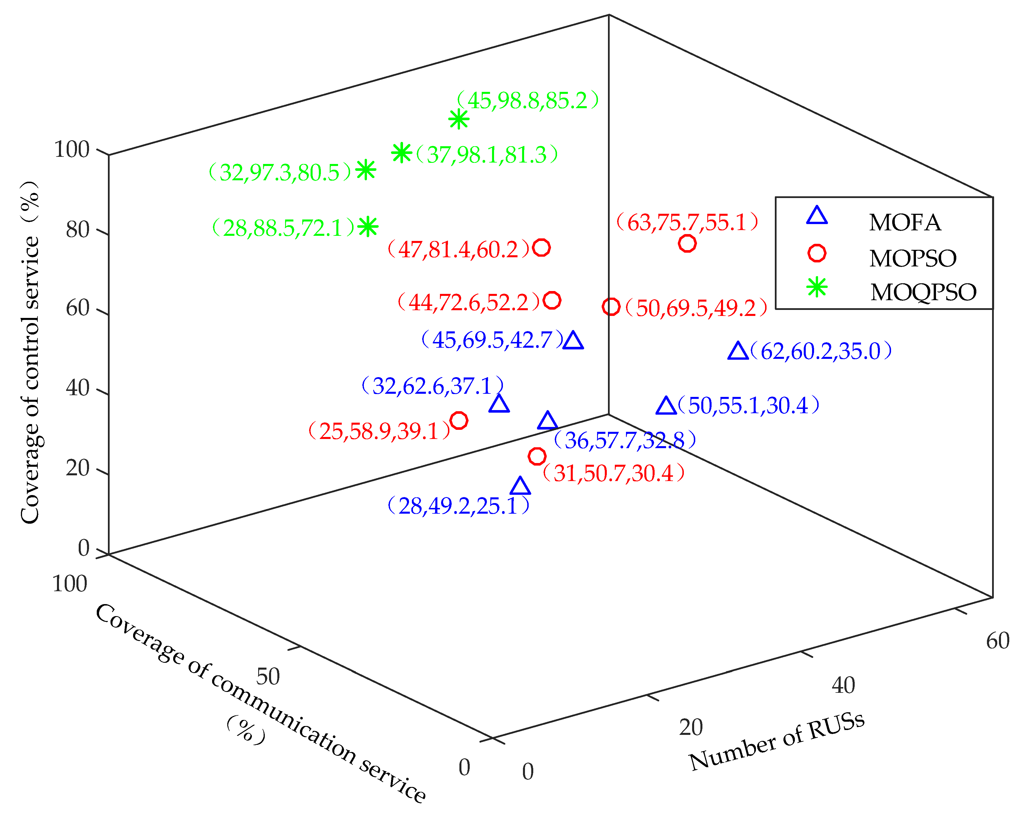
3. Results and Evaluations
4. Discussion
Author Contributions
Funding
Institutional Review Board Statement
Informed Consent Statement
Data Availability Statement
Conflicts of Interest
References
- SAE J3016. Taxonomy and Definitions for Terms Related to Driving Automation Systems for On-Road Motor Vehicles, Society of Automotive Engineers International, USA. 2021. Available online: https://www.sae.org/standards/content/j3016_202104/ (accessed on 2 July 2021).
- GB/T 40429. Taxonomy of Driving Automation for Vehicles, Ministry of Industry and Information Technology, China. 2021. Available online: https://openstd.samr.gov.cn/bzgk/gb/newGbInfo?hcno=4754CB1B7AD798F288C52D916BFECA34 (accessed on 6 October 2021).
- Wang, K.; Zhang, Z.H.; Yang, F.; Hu, X.; Zhou, G.Y. Key Technology of Vehicle-Infrastructure Coordination for High-level Autonomous Driving. Mob. Commun. 2021, 45, 69–76. [Google Scholar]
- The European Road Transport Research Advisory Council (ERTRAC). Connected Automated Driving Roadmap, Europe. 2019. Available online: https://www.ertrac.org/wp-content/uploads/2022/07/ERTRAC-CAD-Roadmap-2019.pdf (accessed on 7 July 2021).
- SAE J3216. Taxonomy and Definitions for Terms Related to Cooperative Driving Automation for On-Road Motor Vehicles, Society of Automotive Engineers International, USA. 2020. Available online: https://www.sae.org/standards/content/j3216_202107/ (accessed on 8 November 2021).
- Institute for AI Industry Research, Tsinghua University (AIR), Baidu Apollo. Key Technology and Prospect of Vehicle-Infrastructure Coordination for Autonomous Driving, China. 2021. Available online: https://pan.baidu.com/s/1moPrXOXMzBQfA89eRgWqOQ?pwd=32W5 (accessed on 25 December 2021).
- Autonomous Driving Working Committee of China Highway and Transportation Society. Classification and Definition for Connected Automated Highway (CAH) Systems, China. 2021. Available online: http://www.chts.cn/module/download/downfile.jsp?classid=0&filename=8271b114bea6483c9af6d0e44eb0186e.pdf (accessed on 18 December 2021).
- Xiong, W.H.; Hu, S.P.; Wang, P.; Zhang, J.H. Research of roadside traffic facilities system and road classification in vehicle infrastructure synergistic environment. Highway 2022, 67, 218–222. [Google Scholar]
- Ran, B.; Tan, H.C.; Zhang, J.; Qu, X. Development status and trend of connected automated vehicle highway system. J. Automot. Saf. Energy 2018, 9, 119–130. [Google Scholar]
- Xu, Z.G.; Li, J.L.; Zhao, X.M.; Li, L. A review on intelligent road and its related key technologies. China J. Highw. Transp. 2019, 32, 1–24. [Google Scholar]
- Jia, Z.P.; Yang, H.H.; Xie, G.J. A deployment scheme for delay-bounded road side unit in VANET. J. Xi’an Jiaotong Univ. 2019, 53, 128–135+166. [Google Scholar]
- Yeferny, T.; Allani, S. MPC: A RSUs deployment strategy for VANET. Int. J. Commun. Syst. 2018, 31, e3712. [Google Scholar] [CrossRef]
- Moura, D.L.L.; Cabral, R.S.; Sales, T.; Aquino, A.L.L. An evolutionary algorithm for roadside unit deployment with betweenness centrality preprocessing. Future Gener. Comput. Syst. 2018, 88, 776–784. [Google Scholar] [CrossRef]
- Chaabene, S.B.; Yeferny, T.; Yahia, S.B. An efficient roadside unit deployment method for vehicular ad-hoc networks. Procedia Comput. Sci. 2020, 176, 771–780. [Google Scholar] [CrossRef]
- Mao, M.; Yi, P.; Zhang, Z.; Wang, L.; Pei, J. Roadside unit deployment mechanism based on node popularity. Mob. Inf. Syst. 2021, 2021, 9980093. [Google Scholar] [CrossRef]
- Salari, M.; Kattan, L.; Gentili, M. Optimal roadside units location for path flow reconstruction in a connected vehicle environment. Transp. Res. Part C Emerg. Technol. 2022, 138, 103625. [Google Scholar] [CrossRef]
- Kui, X.Y.; Du, H.K.; Xiao, X.F.; Li, Y. Traffic amount based road side unit deployment scheme for vehicular network. J. Cent. South Univ. (Sci. Technol.) 2016, 47, 1573–1579. [Google Scholar]
- Xue, L.X.; Yang, Y.C.; Dong, D.C. Roadside infrastructure planning scheme for the urban vehicular networks. Transp. Res. Procedia 2017, 25, 1380–1396. [Google Scholar] [CrossRef]
- Wang, Y.; Zheng, J. Connectivity analysis of a highway with one entry/exit and multiple roadside units. IEEE Trans. Veh. Technol. 2018, 67, 11705–11718. [Google Scholar] [CrossRef]
- Mousa, R.J.; Huszák, Á.; Salman, M.A. Enhancing VANET connectivity through a realistic model for RSU deployment on highway. J. Phys. Conf. Ser. 2021, 1804, 012104. [Google Scholar] [CrossRef]
- Li, Y.; Chen, Z.; Yin, Y.; Peeta, S. Deployment of roadside units to overcome connectivity gap in transportation networks with mixed traffic. Transp. Res. Part C Emerg. Technol. 2020, 111, 496–512. [Google Scholar] [CrossRef]
- Alheeti, K.; Alaloosy, A.; Khalaf, H.; Alzahrani, A.; Dosary, D.A. An optimal distribution of RSU for improving self-driving vehicle connectivity. Comput. Mater. Contin. 2022, 2, 3311–3319. [Google Scholar] [CrossRef]
- Ghorai, C.; Banerjee, I. A constrained delaunay triangulation based RSUs deployment strategy to cover a convex region with obstacles for maximizing communications probability between V2I. Veh. Commun. 2018, 13, 89–103. [Google Scholar] [CrossRef]
- Liu, C.Y.; Huang, H.J.; Du, H.W. Optimal RSUs deployment with delay bound along highways in VANET. J. Comb. Optim. 2017, 33, 1168–1182. [Google Scholar] [CrossRef]
- Yang, H.H.; Jia, Z.P.; Xie, G.J. Delay-bounded and cost-limited RSU deployment in urban vehicular ad hoc networks. Sensors 2018, 18, 2764. [Google Scholar] [CrossRef] [Green Version]
- Ahmed, Z.; Naz, S.; Ahmed, J. Minimizing transmission delays in vehicular ad hoc networks by optimized placement of road-side unit. Wirel. Netw. 2020, 26, 2905–2914. [Google Scholar] [CrossRef]
- Abhishek, N.V.; Aman, M.N.; Lim, T.J.; Sikdar, B. Drive: Detecting malicious roadside units in the internet of vehicles with low latency data integrity. IEEE Internet Things J. 2021, 9, 3270–3281. [Google Scholar] [CrossRef]
- Massobrio, R.; Toutouh, J.; Nesmachnow, S.; Alba, E. Infrastructure deployment in vehicular communication networks using a parallel multiobjective evolutionary algorithm. Int. J. Intell. Syst. 2017, 32, 801–829. [Google Scholar] [CrossRef]
- Nikookaran, N.; Karakostas, G.; Todd, T.D. Combining capital and operating expenditure costs in vehicular roadside unit placement. IEEE Trans. Veh. Technol. 2017, 66, 7317–7331. [Google Scholar] [CrossRef] [Green Version]
- Gao, Z.G.; Chen, D.J.; Yao, N.M.; Lu, Z.M.; Chen, B.C. A novel problem model and solution scheme for roadside unit deployment problem in VANETs. Wirel. Pers. Commun. 2018, 98, 651–663. [Google Scholar] [CrossRef]
- Trullols, O.; Fiore, M.; Casetti, C.; Chiasserinic, C.F.; Ordinasa, J.M.B. Planning roadside infrastructure for information dissemination in intelligent transportation systems. Comput. Commun. 2010, 33, 432–442. [Google Scholar] [CrossRef]
- Dubey, B.B.; Chauhan, N.; Pant, S. Effect of position of fixed infrastructure on data dissemination in vanets. Int. J. Res. Rev. Comput. Sci. 2011, 2, 482–486. [Google Scholar]
- Wang, Z.Y.; Zheng, J.; Wu, Y.Y.; Mitton, N. A Centrality-Based RSU Deployment Approach for Vehicular Ad Hoc Networks. In Proceedings of the 2017 IEEE International Conference on Communications, Paris, France, 21–25 May 2017. [Google Scholar]
- Coello, C.A.C. Evolutionary multi-objective optimization: A historical view of the field. IEEE Comput. Intell. Mag. 2006, 1, 28–36. [Google Scholar] [CrossRef]
- Kennedy, J.; Eberhart, R. Particle swarm optimization. In Proceedings of the International Conference on Neural Networks, Perth, Australia, 27 November–1 December 1995. [Google Scholar]
- Coello, C.A.C.; Lechuga, M.S. MOPSO: A proposal for multiple objective particle swarm optimization. In Proceedings of the 2002 Congress on Evolutionary Computation, Honolulu, HI, USA, 12–17 May 2002. [Google Scholar]
- Sierra, M.R.; Coello, C.A.C. Multi-objective particle swarm optimizers: A survey of the state-of-the-art. Int. J. Comput. Intell. Res. 2006, 2, 287–308. [Google Scholar]
- Sun, J. Particle Swarm Optimization with Particles Having Quantum Behavior; Jiangnan University: Wuxi, China, 2009. [Google Scholar]
- Knowles, J.D.; Corne, D.W. Approximating the nondominated front using the Pareto archived evolution strategy. Evol. Comput. 2000, 8, 149–172. [Google Scholar] [CrossRef]
- Deb, K.; Pratap, A.; Agarwal, S.; Meyarivan, T. A fast and elitist multiobjective genetic algorithm: NSGA-II. IEEE Trans. Evol. Comput. 2002, 6, 182–197. [Google Scholar] [CrossRef] [Green Version]
- Yang, X.S. Multiobjective firefly algorithm for continuous optimization. Eng. Comput. 2013, 29, 175–184. [Google Scholar] [CrossRef] [Green Version]
- Nguyen, S.; Dupuis, S. An efficient method for computing traffic equilibria in networks with asymmetric transportation costs. Transp. Sci. 1984, 1, 185–202. [Google Scholar] [CrossRef]
- Zhang, L.L.; Zhao, Q.; Yu, P.; Li, J.; Yao, D.; Wang, X.; Wang, L.; Zhang, L. Research on integrated simulation platform for urban traffic control connecting simulation and practice. Sci. Rep. 2022, 12, 4536. [Google Scholar] [CrossRef] [PubMed]


| Serial No. | /km | Serial No. | /km | ||
|---|---|---|---|---|---|
| 1 | 2.8 | 13 | 11 | [0.8, 0.87) | 45 |
| 2 | [1.8, 2.8) | 18 | 12 | [0.74, 0.8) | 46 |
| 3 | [1.4, 1.8) | 25 | 13 | [0.7, 0.74) | 47 |
| 4 | [1.3, 1.4) | 28 | 14 | [0.67, 0.7) | 50 |
| 5 | [1.2, 1.3) | 29 | 15 | [0.65, 0.67) | 51 |
| 6 | [1.1, 1.2) | 31 | 16 | [0.6, 0.65) | 52 |
| 7 | [1.0, 1.1) | 32 | 17 | [0.56, 0.6) | 62 |
| 8 | [0.94, 1.0) | 36 | 18 | [0.55, 0.56) | 63 |
| 9 | [0.9, 0.94) | 37 | 19 | [0.51, 0.55) | 64 |
| 10 | [0.87, 0.9) | 44 | 20 | (0, 0.51) | ≥65 |
Disclaimer/Publisher’s Note: The statements, opinions and data contained in all publications are solely those of the individual author(s) and contributor(s) and not of MDPI and/or the editor(s). MDPI and/or the editor(s) disclaim responsibility for any injury to people or property resulting from any ideas, methods, instructions or products referred to in the content. |
© 2023 by the authors. Licensee MDPI, Basel, Switzerland. This article is an open access article distributed under the terms and conditions of the Creative Commons Attribution (CC BY) license (https://creativecommons.org/licenses/by/4.0/).
Share and Cite
Zhang, L.; Wang, L.; Zhang, L.; Zhang, X.; Sun, D. An RSU Deployment Scheme for Vehicle-Infrastructure Cooperated Autonomous Driving. Sustainability 2023, 15, 3847. https://doi.org/10.3390/su15043847
Zhang L, Wang L, Zhang L, Zhang X, Sun D. An RSU Deployment Scheme for Vehicle-Infrastructure Cooperated Autonomous Driving. Sustainability. 2023; 15(4):3847. https://doi.org/10.3390/su15043847
Chicago/Turabian StyleZhang, Lingyu, Li Wang, Lili Zhang, Xiao Zhang, and Dehui Sun. 2023. "An RSU Deployment Scheme for Vehicle-Infrastructure Cooperated Autonomous Driving" Sustainability 15, no. 4: 3847. https://doi.org/10.3390/su15043847