Article

Investigating the Relationship between Plant Species Composition and Topography in the Tomeyama Landslide: Implications for Environmental Education and Sustainable Management in the Happo-Shirakami Geopark, Japan

1
Faculty of Agriculture and Life Science, Hirosaki University, Aomori 036-8561, Japan
2
The Shirakami Research Center for Environmental Sciences, Faculty of Agriculture and Life Science, Hirosaki University, Aomori 036-8561, Japan
3
United Graduate School of Agricultural Sciences, Iwate University, Morioka 020-8550, Japan
4
Faculty of Education, Hirosaki University, Aomori 036-8560, Japan
5
Happo-Shirakami Geopark Promotion Council, Akita 018-2502, Japan
*
Author to whom correspondence should be addressed.
Sustainability 2023, 15(24), 16572; https://doi.org/10.3390/su152416572
Submission received: 22 September 2023 / Revised: 22 November 2023 / Accepted: 1 December 2023 / Published: 5 December 2023
(This article belongs to the Special Issue Sustainability in Natural Hazards Mitigation and Landslide Research)

Abstract

:
The Tomeyama landslide in the Happo-Shirakami Geopark, Japan, has interesting and important geomorphological and geoecological characteristics. Understanding these characteristics is crucial for environmental education and sustainable management in the geopark. In this study, we quantified the characteristics of the landslide, including its precise topography and vegetation. We used high-resolution 2.5 m-mesh ALOS World 3D topographic data to define the topography of the landslide. We also surveyed plant species composition and cover in four plots (three on the upper slope and one on the convex lower foot slope), each measuring 20 m × 20 m. Our findings reveal that the landslide is sited on a northwest-facing slope, 250 m below the ridge top, and has a horseshoe-shaped main scarp with a height of 40 m. Two smaller secondary scarps and their corresponding displaced landslide blocks suggest reactivation since the main landslide event. In the upper slope plots, 40–55 plant species were identified, including 14–16 species associated with the Japanese beech forest and 2–5 species related to the Pterocarya rhoifolia forest. In the lower slope plot, 70 plant species were identified, including 14 species from the Japanese beech forest and 11 from the Pterocarya rhoifolia forest. The upper slope plant community belongs to the Japanese beech forest; however, categorizing the lower slope community is challenging, although more Pterocarya rhoifolia forest species are present compared with the upper slope. These results suggest that certain plant species have adapted to the diverse topography created by the landslide. These findings improve the understanding of landslide topography and plant community composition with respect to environmental factors and thereby support effective environmental education and sustainable management in the Happo-Shirakami Geopark.

1. Introduction

The intricate interplay of geological processes, ecosystem dynamics, and anthropogenic activities influences the landscapes that humans inhabit. Of these dynamic interactions, landslides have emerged as captivating phenomena that offer a distinctive lens into the interplay between Earth’s processes and the delicate equilibrium of its ecosystems [1]. For instance, within landslide regions, intricate and diverse terrain features with unique slope configurations, soil compositions, and moisture conditions contrast with those of the surrounding landscape [2,3]. The elaborate terrain features of landslides, which are characterized by intricate undulations and complexities, are thought to facilitate the colonization of diverse forest plant species [4,5,6]. The ecological milieu of landslide areas showcasing these distinct attributes has the potential to function as educational material for environmental instruction, encouraging an appreciation of natural surroundings and conservation consciousness. Moreover, these attributes have implications for the integration of environmental education and sustainable management practices.
Efforts in environmental education related to landslides have focused predominantly on highlighting their geomorphological and geological formation processes [7]. Furthermore, some initiatives have involved the preservation and utilization of the landforms sculpted by landslides or the remnants of structures impacted by such events [8]. Exemplary cases include sites that showcase intricate geological and geomorphic formation processes, such as the establishment of a geological and landslide museum in Civita di Bagnoregio, Italy [9], as well as field-based educational endeavors along the Dorset and eastern Devon coasts in England [10,11] and within the Picos de Europa National Park in Spain [12]. Moreover, sites preserving the effects of human-induced landslides, such as the Vajont landslide in Italy [8], the Chiu-fen-erh-shan landslide following the 1999 Chi-Chi earthquake in Taiwan [13], and the Aratozawa landslide triggered by the 2008 Iwate–Miyagi inland earthquake in Japan [14], together with their associated structures, have been considered instructive examples. However, there are limited cases in which the relationship between plant species composition and terrain characteristics in landslide areas has been incorporated actively into on-site educational approaches.
This study was conducted in the Tomeya landslide, situated in the Happo-Shirakami geopark, Japan (Figure 1a,b). It is worth noting that there is an existing research gap concerning the comprehensive investigation of plant species composition and topography in the study area. The primary objective of the study was to investigate the relationship between plant species composition and the topography of this landslide. In addition, the study considers the implications of the findings for environmental education.

2. Study Area

The Tomeyama landslide is located on a gentle slope of the Shirakami mountains, where 13% of the area has been designated as a Natural World Heritage site. The landslide spans an elevation of approximately 150–250 m (Figure 1c). Determining the timing and the driving factor behind the landslide occurrence is challenging due to the scarcity of historical records in and around the study area. The geology of the Tomeyama landslide comprises a lower layer of Late Miocene to Early Pliocene mudstone and an upper layer of andesite and its associated pyroclastic rock (Figure 1d) [16]. The andesite volcanic event has a history eruptions dating back to 6.6 Ma [17]. Vegetation in the study area consists of a cool-temperate deciduous broad-leaved forest, composed mainly of Siebold’s beech (Fagus crenata) and Pterocarya rhoifolia. The average annual rainfall in Happo town from 1991 to 2020 was 1501.6 mm; the largest monthly total rainfall occurred in July (172.2 mm) and the smallest in February (68.9 mm) [18].
The forest around the Tomeyama landslide has been protected from logging since the Hansei period (1603–1868). The landslide presently functions as a geosite within the Happo-Shirakami Geopark and plays a crucial role in environmental education initiatives. Visitors to the Tomeyama landslide totaled 1668, 1329, and 1415 in 2019, 2020, and 2021, respectively [19].

3. Methods

3.1. Landslide Topography

Landslide topography was interpreted utilizing a CS stereogram derived from a 2.5 m-mesh AW3D digital elevation model (DEM). The CS stereogram was generated using the CSMapMaker plugin in QGIS [20]. This CS stereogram includes two sets of curvature and slope layers (Figure 2). During the generation of the CS stereogram, a color ramp and a 50% transparency were applied to these layers. Results of the CS stereogram were validated in the field.

3.2. Surveys of Plant Species Composition and Cover

Plant species composition and cover were surveyed within square plots measuring 20 m on each side on the upper slope of the displaced landslide block (Plots 1, 2, and 4) and on the lower slope near the toe of the displaced block (Plot 3) of the landslide (Figure 3 and Figure 4). Due to the steep slope at the toe of the landslide, making it unsuitable for the survey, Plot 3 was chosen on the lower slope near the toe of the displaced block. It is worth noting that the vegetation in this area is visually similar to that found on the toe of the landslide. In each plot, 16 sub-plots were separated by 5 m intervals. Field surveys were conducted on 19 and 26 July 2022.
Slope angles are steeper on the lower slope near the toe of the landslide compared with the upper slope. In the upper slope plots, the distribution of slope angles followed a normal distribution, with Plot 1 having a modal value of 20°–25°, whereas Plots 2 and 4 had a modal value of 10°–15° (Figure 5). The mean slope angles in Plots 1, 2, and 4 were 20.0°, 16.5°, and 12.1°, respectively. In Plot 3, near the toe of the landslide, slope angle exhibited a normal distribution with a mode of 25°–30° and a mean slope angle of 25.2°.
All plant species within each sub-plot of the four survey plots were identified and recorded in four layers of vertical structure (herb layer: 0–1.5 m, shrub layer: 1.5–5 m, understory layer: 5–8 m, and canopy layer: >8 m). The plant cover of each layer was estimated by visual assessment of the percentage of the sub-plot covered by each plant species and recorded using a scale of six coverage classes [21]: class 5 (75–100%), class 4 (50–75%), class 3 (25–50%), class 2 (10–25%), class 1 (<10%), and class “+” (for very few individuals accounting for less than 1% of the area) [22]. In cases where the same species appeared in multiple layers, the highest coverage class observed among the layers was assigned.
The classification of the surveyed vegetation into existing communities was determined based on phytosociology. This determination involved referring to the characteristic and differential species of specific plant communities that have been reported in the vicinity of the survey area [23,24].

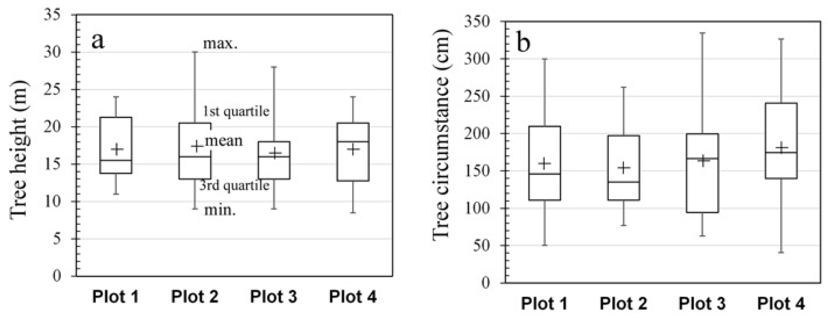
4. Results and Discussion

4.1. Landslide Topography

The Tomeyama landslide is approximately 350 m wide and 450 m long and has an area of about 0.1 km2 (Figure 6). The landslide occurred below an elevation of approximately 250 m, and the displaced block extends in front of a main scarp with a height of 40 m. The main scarp constitutes a horseshoe-shaped cliff facing predominantly northwest. The slope of the landslide generally faces northwest, with the distal end facing the river. The displaced block of the landslide exhibits gentle hilly terrain, with the mid-slope area having a slope angle of approximately 5°–15°. Small valleys are distributed within the displaced block and formed after the occurrence of the landslide. The distal end of the displaced block has convex steep slopes with slope angles exceeding 30°.
On the main scarp, two smaller horseshoe-shaped scarps can be observed (Figure 6a). Below each of these two smaller secondary scarps, small-scale displaced bodies corresponding to each scarp are observed, suggesting the occurrence of secondary landslides associated with the enlargement of the pre-existing main landslide scarp. In addition, the displaced bodies of the secondary landslides have been pushed and accumulated into the back part of the main displaced block, creating concave areas with a maximum width of approximately 50–60 m (Figure 6). The landslide has been mapped previously from aerial photographs [15], which revealed a main landslide scarp and its related displaced block (Figure 1c). Our topographic investigation confirms the main scarp but additionally identifies the horseshoe-shaped smaller scarps, displaced bodies, and concave areas formed by secondary landslides. The topography resulting from the secondary landslide was also observed during the field study.

4.2. Plant Species Composition and Cover Surveys

The numbers of species and plants observed in each layer of vertical structure are shown for Plots 1 to 4 in Figure 7. Only the number of species was recorded for the herb layer, on account of the difficulty in determining the exact number of plants for this layer. The results indicate that, regardless of the survey plot, the number of species was highest in the herb layer, followed by the shrub layer. In addition, the number of plants was highest in the shrub layer, followed by the canopy and understory layers.
Figure 8 presents the results for tree height and circumstance at breast height in the canopy layer for Plots 1 to 4. The mean height of trees in each plot ranged from 16.4 to 17.5 m, with the tallest tree being Fagus crenata, reaching 30 m in Plot 2. The mean circumstance ranged from 1.6 m for Plots 1 to 3 to 1.8 m for Plot 4.
Table 1, Table 2, Table 3 and Table 4 provide summaries of the plant species composition and coverage classes for the upper slope of the displaced block (Plots 1, 2, and 4) and the lower slope near the toe of the displaced block (Plot 3) of the Tomeyama landslide.
In Plots 1, 2, and 4 on the gentle upper slope, totals of 39, 56, and 45 plant species were observed, respectively. Of these, 14 to 16 species were identified as character and differential species of Japanese beech forest, accounting for nearly half of the species in the herb layer. Moreover, character species strongly associated with this forest community, such as Lindera umbellata var. membranacea Moriyama, Aucuba japonica var. borealis Miyabe et Kudo, Disporum smilacinum, and Hamamelis japonica var. obtusata Matsumura were present with a higher coverage class. In contrast, only 2–5 species were identified as character and differential species of Pterocarya rhoifolia forest.
On the lower slope near the toe of the landslide (Plot 3), a total of 70 plant species were identified. Of these, 14 species were recognized as character and differential species of Japanese beech forest. The percentages of plant cover of the identified character species of this forest community, including Lindera umbellata var. membranacea Moriyama, Aucuba japonica var. borealis Miyabe et Kudo, and Disporum smilacinum, were low, with the Aucuba japonica var. borealis Miyabe et Kudo falling in class 2, Lindera umbellata var. membranacea Moriyama in class 1, and Disporum smilacinum in class “+” in the coverage class system used in this study. In contrast, 11 species were identified as character and differential species of Pterocarya rhoifolia forest. The percentages of plant cover of the identified character species of this forest community, including Elatostema japonicum var. majus, Viola vaginata, and Dryopteris monticola, were low, falling in class “+”.
On the basis of the presented results, it is concluded that the vegetation observed in the survey plots on the gentle upper slope belongs to the Japanese beech forest (Figure 9). Determining the community to which the vegetation on the lower slope near the toe of the landslide belongs is challenging, although a greater number of species related to the Pterocarya rhoifolia forest were found in the plot on the lower slope compared with the plots on the upper slope. Plant community composition differences were observed between the upper and lower slopes of the landslide.
Previous studies have explored the relationship between plant community composition and the geomorphic environment of the Shirakami mountains. Mishima et al. [4] conducted surveys within a landslide area located on the eastern side of the Shirakami mountains, including evaluations of vegetation, subsoil structure, and soil erosion levels. They recorded the presence of Japanese beech forest on the arid upper slope of the landslide, where the soil layer is minimal. In contrast, Pterocarya rhoifolia forest displayed a preference for the moister conditions on the lower slope. Comparable observations have been reported by Tsou et al. [25] for a landslide area on the western side of the Shirakami mountains. Our results reveal similarities with previous studies. It is worth noting that the Japanese beech forest represents the climatic climax forest of the northern Japan Sea region, whereas the Pterocarya rhoifolia forest is the most widely distributed community within the topographic climax forest of the Shirakami mountains [26].
In this study, we investigated the relationship between the present composition of plant communities and topography of the Tomeyama landslide. However, it is essential to acknowledge that plant species composition is also influenced by environmental variables such as aspect, soil porosity, and saturation moisture content, among others [27], which could be the focus of future studies. In addition, the present plant composition and distribution of plant communities could also be influenced by the timescale of post-landslide geomorphic evolution, the process of vegetation succession, and the pace of these transitions [1,28,29]. The present plant composition and distribution of plant communities is likely an outcome of the interplay between these dynamic temporal aspects, which should be investigated in a future study.

4.3. Enhancing Enviromental Education and Sustainable Management

With the aim of enhancing environmental education and sustainable management, we generated a trifold brochure (Figure 10 and Figure 11) to offer the general public insights into the natural environment of the Tomeyama landslide. This content is centered on the relationship between plant species composition and topography of the landslide area. Figure 10 presents the front side of the brochure, which provides general details about the Tomeyama landslide. Figure 11 presents the back side of the brochure, which summarizes the information from Section 4.1 and Section 4.2 of this paper. Guides who introduce visitors to the Tomeyama area are expected to utilize the brochure, making it also valuable for environmental education in schools and local communities. As noted by Koizumi and Chakraborty [30], incorporating environmental education regarding the local geoecological system is crucial for sustainable management, which should be based on knowledge of the natural environment. As a result, the findings of our study make a significant contribution to environmental education and sustainable management.

5. Conclusions

This study focused on enhancing environmental education and sustainable management by measuring the relationship between the plant species composition and the topography of the Tomeyama landslide in the Happo-Shirakami Geopark, Japan. Topographic analysis shows that the landslide occupies a relatively compact space of approximately 0.1 km2. This landslide originated from a large-scale primary movement and subsequently underwent reactivation, particularly along its main scarp, producing secondary scarps and displaced bodies. Our study included thorough surveys of plant species composition and cover across four plots, each measuring 20 m × 20 m: three on the upper slope and one on the convex lower foot slope. Results revealed rich plant diversity. On the upper slope, 40–55 plant species were identified, with 14–16 species related to the Japanese beech forest but only 2–5 species related to the Pterocarya rhoifolia forest. The lower slope plot contained 70 species, including 14 from the Japanese beech forest and 11 from the Pterocarya rhoifolia forest. Although categorizing the plant community of the lower slope proved challenging, there was a higher representation of Pterocarya rhoifolia forest species compared with the upper slope. These results indicate that specific plant species have adapted to the varying topography induced by the landslide. We have generated a trifold brochure to enhance environmental education and sustainable management by disseminating the information obtained in this study. This brochure will be used by Happo-Shirakami Geopark guides and for environmental education in schools and local communities.

Author Contributions

Conceptualization: C.-Y.T., H.Y. and M.-F.T.; data curation: C.-Y.T., H.Y., R.K. and T.M.; methodology: C.-Y.T., H.Y. and M.-F.T.; analysis: C.-Y.T., H.Y., R.K. and M.-F.T.; supervision: C.-Y.T. and T.M.; writing—original draft: C.-Y.T., H.Y. and T.M.; writing—review and editing: C.-Y.T. All authors have read and agreed to the published version of the manuscript.

Funding

This research was funded by a research grant from the Geoparks of Akita Prefecture in 2022.

Institutional Review Board Statement

Not applicable.

Informed Consent Statement

Not applicable.

Data Availability Statement

Data are available upon request.

Acknowledgments

Akira Takahashi, Aya Ogasawara, and Masako Nejo provided valuable assistance during the field surveys. Insightful discussions with Shintaro Hayashi of Akita University, the Happo-cho Shirakami Guiding Association, and the Happo-cho Shirakami Geopark Guiding Association contributed greatly to this study.

Conflicts of Interest

The authors declare no conflict of interest.

References

  1. Walker, L.R.; Shiels, A.B.; Bellingham, P.J.; Sparrow, A.D.; Fetcher, N.; Landau, F.H.; Lodge, D.J. Changes in abiotic influences on seed plants and ferns during 18 years of primary succession on Puerto Rican landslides. J. Ecol. 2013, 101, 650–661. [Google Scholar] [CrossRef]
  2. Takaoka, S. Effects of landslides on vegetation with special reference to significance of studies from a geohistorical viewpoint. Veg. Sci. 2013, 30, 133–144, (In Japanese with English Abstract). [Google Scholar] [CrossRef]
  3. Guariguata, M.R. Landslide disturbance and forest regeneration in the Upper Luquillo Mountains of Puerto Rico. J. Ecol. 1990, 78, 814–832. [Google Scholar] [CrossRef]
  4. Mishima, Y.; Higaki, D.; Makita, H. Relationship between microtopography and plants in a small landslide area in the Shirakami Mountains. Q. J. Geogr. 2009, 61, 109–118, (In Japanese with English Abstract). [Google Scholar] [CrossRef]
  5. Sakai, A.; Ohsawa, M. Vegetation pattern and microtopography on a landslide scar of Mt Kiyosumi, central Japan. Ecol. Res. 1993, 8, 47–56. [Google Scholar] [CrossRef]
  6. Seiwa, K.; Miwa, Y.; Akasaka, S.; Kanno, H.; Tomita, M.; Saitoh, T.; Ueno, N.; Kimura, M.; Hasegawa, Y.; Konno, M.; et al. Landslide-facilitated species diversity in a beech-dominant forest. Ecol. Res. 2013, 28, 29–41. [Google Scholar] [CrossRef]
  7. Morino, C.; Coratza, P.; Soldati, M. Landslides, a key landform in the global geological heritage. Front. Earth Sci. 2022, 10, 864760. [Google Scholar] [CrossRef]
  8. Galadini, F. Ruins and remains as a background: Natural catastrophes, abandonment of medieval villages, and the perspective of civilization during the 20th century in the central Apennines (Abruzzi Region, Central Italy). Sustainability 2022, 14, 9517. [Google Scholar] [CrossRef]
  9. Margottini, C.; Di Buduo, G. The geological and landslides museum of Civita di Bagnoregio (Central Italy). Landslides 2017, 14, 435–445. [Google Scholar] [CrossRef]
  10. May, V. Integrating the geomorphological environment, cultural heritage, tourism and coastal hazards in practice. Geogr. Fis. E Din. Quat. 2008, 31, 187–194. [Google Scholar]
  11. Brunsden, D.; Edmonds, R. The Dorset and East Devon coast: England’s geomorphological world heritage site. In Geomorphological Landscapes of the World; Migon, P., Ed.; Springer: Dordrecht, The Netherlands, 2009. [Google Scholar]
  12. Serrano, E.; José, J.; Trueba, G. Environmental education and landscape leisure. Geotourist map and geomorphosites in the Picos de Europa National Park. Geoj. Tour. Geosites 2011, 8, 295–308. [Google Scholar]
  13. Wu, J.H.; Hsieh, P.H. Simulating the postfailure behavior of the seismically- triggered Chiu-fen-erh-shan landslide using 3DEC. Eng. Geol. 2021, 287, 106113. [Google Scholar] [CrossRef]
  14. Miyagi, T.; Sato, H.; Nakagawa, R. Aratozawa massive landslide, Kurihara Japan—Idea to the geo-park site. In Proceedings of the General Meeting of the Association of Japanese Geographers, Tokyo, Japan, 29 March 2015. (In Japanese). [Google Scholar]
  15. Shimizu, F.; Oyagi, N.; Inokuchi, T. 1:50,000 Landslide Distribution Map; National Research Center for Disaster Prevention: Hirosaki/Fukaura, Japan, 1985; Volume 3.
  16. Ozawa, A.; Tsuchiya, N.; Sumi, K. Geology of the Nakahama District; Quadrangle Series Scale 1:50,000; Geological Survey of Japan: Tsukuba, Japan, 1983; p. 62. [Google Scholar]
  17. Tsuchiya, N. Recent problems of the Tertiary volcanism in northeast Honshu. Chishitsu News 1994, 482, 42–48. (In Japanese) [Google Scholar]
  18. Japanese Meteorological Agency. Averaged Values from the Start of Observations, Hachimori: Monthly and Yearly. Available online: https://www.data.jma.go.jp/obd/stats/etrn/view/nml_amd_ym.php?prec_no=32&block_no=1043&year=&month=&day=&view= (accessed on 26 August 2023).
  19. Miwa, T.; (Happo-Shirakami Geopark Promotion Council, Akita, Japan). Number of visits to the Tomeyama landslide. Personal communication, 2022. [Google Scholar]
  20. Toda, K. Topographic interpretation using curvature and slope-based 3D visualization (CS stereogram). Jpn. Soc. For. Environ. 2014, 56, 75–79. (In Japanese) [Google Scholar] [CrossRef]
  21. The Japanese Society of Forest Environment. Vegetation. In Forest Survey Method: Measuring the Forest Environment; Hakuyusha: Tokyo, Japan, 2010; pp. 43–86. (In Japanese) [Google Scholar]
  22. Braun-Blanquet, J. Pflanzensoziologie, Grundzüge der Vegetationskunde, 3rd ed.; Springer: Vienna, Austria, 1964. [Google Scholar]
  23. Saitoh, N.; Saitoh, M.; Makita, M.; Naito, T. Vegetation of Shirakami Mountains. In 1994 Fiscal Year Report on Comprehensive Survey of Designated Natural Forests; Report on Comprehensive Survey of Shirakami Mountain Natural Environment Conservation Area; Natural Parks Association of Japan: Tokyo, Japan, 1995; pp. 103–141. (In Japanese) [Google Scholar]
  24. Takaya, S.; Saitoh, N.; Kobayashi, H.; Kakizaki, K.; Oda, M. Vegetation. In Nature of Shirakami Mountains; Aomori Prefectural Museum: Aomori, Japan, 1996; pp. 14–41. (In Japanese) [Google Scholar]
  25. Tsou, C.-Y.; Takuchi, I.; Sato, R.; Ishikawa, Y.; Higaki, D.; Tsai, M.-F.; Igarashi, H.; Yamabe, K. Geomorphological and geoecological evaluation in relation to tourism in the Tsugaru-Juniko landslide area, Japan. Eur. J. Environ. Earth Sci. 2023, 18, 142–156, (In Japanese with English Abstract). [Google Scholar] [CrossRef]
  26. Saitoh, N. The indices to the local vegetation. In The Indices to the Vegetation of Japan: Community Names and Subjects (Tohoku); Miyawaki, A., Ed.; Shibundo: Tokyo, Japan, 1987; pp. 443–451. (In Japanese) [Google Scholar]
  27. Moradi, G.; Vacik, H. Relationship between vegetation types, soil and topography in southern forests of Iran. J. For. Res. 2018, 29, 1635–1644. [Google Scholar] [CrossRef]
  28. Walker, L.R.; Shiels, A.B. Landslide Ecology; Cambridge University Press: Cambridge, UK, 2013. [Google Scholar]
  29. Xiang, Z.; Dou, J.; Yunus, A.P.; Zhang, L.; Wang, X.; Luo, W. Vegetation-landslide nexus and topographic changes post the 2004 Mw 6.6 Chuetsu earthquake. Catena 2023, 223, 106946. [Google Scholar] [CrossRef]
  30. Koizumi, T.; Chakraborty, A. Geoecotourism and environmental conservation education: Insights from Japan. GeoJournal 2016, 81, 737–750. [Google Scholar] [CrossRef]
Figure 1. Maps and photograph of the Tomeyama study area, showing the location, topography, and geology. (a) Location map (modified from the GSI Tile published by the Geospatial Information Authority of Japan). (b) NE-oriented photograph of the Tomeyama landslide. (c) Topography of the Tomeyama landslide (modified from the 1:25,000 scale topographic map published by the Geospatial Information Authority of Japan). The representation of the landslide scarp and displaced block is from [15]. (d) Geological map of the study area (from [16]).
Sustainability 15 16572 g001
Figure 2. Example of the generation of a CS stereogram following the process described by [20].
Sustainability 15 16572 g002
Figure 3. Surveyed plots of plant species composition and cover. The red polyline indicates the walking route designated for visitors.
Sustainability 15 16572 g003
Figure 4. Photographs of survey plots showing plant species composition and cover. (a) Plot 1; (b) Plot 2; (c) Plot 3; (d) Plot 4. Plot locations are shown in Figure 3.
Sustainability 15 16572 g004
Figure 5. Percentage frequency distributions of slope gradient in survey plots of plant species composition and cover.
Sustainability 15 16572 g005
Figure 6. Topography and topographic cross-section of the Tomeyama landslide. (a) Landslide topography interpreted using a CS stereogram; (b) topographic cross-section of the landslide (X-Y, location shown in (a). The cross-section is from the AW3D DEM.
Sustainability 15 16572 g006
Figure 7. Number of identified species (all layers) and plant counts (excluding the herb layer) stratified by vegetation survey for (ad) Plots 1 to 4.
Sustainability 15 16572 g007
Figure 8. Survey results for the canopy layer in vegetation survey Plots 1 to 4. (a) Tree height; (b) tree diameter at breast height.
Sustainability 15 16572 g008
Figure 9. Schematic diagram illustrating differences in plant community composition related to the topography between the upper and lower slopes of the displaced landslide block. The legend shows plant species that closely related to the plant community composition and high coverage class of plant cover.
Sustainability 15 16572 g009
Figure 10. Proposed trifold brochure (front side).
Sustainability 15 16572 g010
Figure 11. Proposed trifold brochure (back side).
Sustainability 15 16572 g011
Table 1. Summary of plant species and their coverage classes in Plot 1.
Plant SpeciesCoverPlant Species Cover
Lindera umbellata var. membranacea Moriyama 1,45 Pyrola japonica 3+
Sasa senanensis (Fr. Et Sav.) Rehder 35 Ilex crenata Thunb. 3+
Aucuba japonica var. borealis Miyabe et Kudo 1,45 Acer rufinerve 3+
Acer japonicum Thunb. 14 Daphniphyllum macropodum var. humile Rosenthal 1+
Acanthopanax sciadophylloides Franch. Et Savat. 14 Menziesia multiflora Maxim. Var. longicalyx 3+
Acer palmatum var. matsumurae Makino 33 Symplocos chinensis var. leucocarpa f. pilosa Ohwi 3+
Fagus crenata Blume 12 Blechnum niponicum 1+
Viburnum furcatum Blume 12 Disporum smilacinum 1,4+
Sasa senanensis var. senanensis 32 Hydrangea petiolaris Sieb. Et Zucc. 3+
Euonymus oxyphyllus Miq. Var. oxyphy 32 Mitchella undulata 3+
Schizophragma hydrangeoides Sieb. Et Zucc. 11 Huperzia serrata 3+
Prunus grayana Linn. 31 Mognolia obovate Thunb. 1+
Carex sp. 31 Hamamelis japonica var. obtusata Matsumura 1,4+
Rhus ambigua Lavallee 11 Parasenecio delphiniifolius var. delphiniifolius 2,4+
Cephalotaxus harringtonia var. nana Rehd. 11 Rhus trichocarpa Miq. 3+
Ardisia japonica Blume 31 Styras obassia Sieb. Et Zucc. 3+
Sorbus alnifolia C. Koch 31 Styrax japonica Sieb. Et Zucc. 3+
Fraxinus lanuginosa Koidz. 3+Wisteria floribunda DC. 3+
Acer mono Maxim. 2+Callicarpa japonica Thunb. 3+
Maianthemum japonicum 3+
1 Species related to the Japanese beech forest [23,24]. 2 Species related to the Pterocarya rhoifolia forest [23,24]. 3 Neither of the above [23,24]. 4 Bold: indicator species [24].
Table 2. Summary of plant species and their coverage classes in Plot 2.
Plant Species CoverPlant Species Cover
Lindera umbellata var. membranacea Moriyama 1,44Galium odoratum 3+
Sasa senanensis (Fr. Et Sav.) Rehder 34Lilium medeoloides var. medeoloides 3+
Viburnum furcatum Blume 14Actinidia argute Planch. 3+
Viburnum dilatatum Thunb. 33Acanthopanax sciadophylloides Franch. Et Savat. 1+
Aucuba japonica var. borealis Miyabe et Kudo 1,43Smilax china Linn. 3+
Maianthemum dilatatum 33Blechnum niponicum 1+
Acer japonicum Thunb. 13Euonymus oxyphyllus Miq. Var. oxyphy 3+
Fagus crenata Blume 12Mitchella undulata 3+
Schizophragma hydrangeoides Sieb. Et Zucc. 12Skimmia japonica var. intermedia f. repens Hara 1+
Menziesia multiflora Maxim. Var. longicalyx 32Tripterospermum japonicum var. japonicum 3+
Carex sp. 32Panax japonicus var. japonicus 2+
Hydrangea petiolaris Sieb. Et Zucc. 32Viola rostrata 3+
Tripetaleia paniculata Sieb. Et Zucc. 32Sorbus commixta Hedl. 1+
Acer rufinerve 31Hydrangea paniculata Sieb. 3+
Prunus grayana Linn. 31Cephalotaxus harringtonia var. nana Rehd. 1+
Daphniphyllum macropodum var. humile Rosenthal 11Phryma leptostachya subsp. Asiatica var. asiatica 3+
Calanthe discolor var. discolor 31Leucothoe grayana Maxim. 3+
Disporum smilacinum 1,41Ilex leucoclada Makino 1+
Rhus ambigua Lavallee 11Wisteria floribunda DC. 3+
Ilex crenata var. paludosa Hara 31Solidago virgaurea subsp. Leiocarpa var. leiocarpa 3+
Callicarpa japonica Thunb. 31Polygonatum lasianthum Maxim. 3+
Rhus trichocarpa Miq. 31Parasenecio delphiniifolius var. delphiniifolius 2,4+
Solidago virgaurea subsp. Asiatica var. asiatica 3+Athyrium vidalii 3+
Fraxinus lanuginosa Koidz. 3+Rhododendron kaempferi Planch. 3+
Acer mono Maxim. 2+Acer palmatum var. matsumurae Makino 3+
Abelia spathulata var. stenophylla 1+Prunus sargentii Rehder 3+
Quercus crispula Blume 1+Styras obassia Sieb. Et Zucc. 3+
Menziesia multiflora Maxim. 3+Clethra barbinervis Sieb. Et Zucc. 3+
1 Species related to the Japanese beech forest [23,24]. 2 Species related to the Pterocarya rhoifolia forest [23,24]. 3 Neither of the above [23,24]. 4 Bold: indicator species [24].
Table 3. Summary of plant species and their coverage classes in Plot 3.
Plant Species CoverPlant Species Cover
Sasa senanensis (Fr. Et Sav.) Rehder 34Acanthopanax sciadophylloides Franch. Et Savat. 1+
Carex sp. 34Euonymus alatus var. alatus f. striatus 3+
Hydrangea petiolaris Sieb. Et Zucc. 34Polystichum retrosopaleaceum 2+
Acer japonicum Thunb. 14Prunus ssiori Fr. Schm. 3+
Viburnum furcatum Blume 13Blechnum niponicum 1+
Aesculus turbinata Blume 23Viola vaginata 2,4+
Rubus buergeri 33Osmunda japonica+
Dryopteris sabaei 13Smilax nipponica+
Dryopteris crassirhizoma 22Disporum smilacinum 1,4+
Athyrium clivicola 32Paris tetraphylla var. tetraphylla 1+
Rubus crataegifolius 32Rhus ambigua Lavallee 1+
Aucuba japonica var. borealis Miyabe et Kudo 1,42Viola verecunda var. verecunda 3+
Arachniodes borealis 32Huperzia serrata 3+
Diplazium sibiricum var. glabrum 32Ulmus pumila Linn. 3+
Lindera umbellata var. membranacea Moriyama 1,41Adenocaulon himalaicum 3+
Viburnum dilatatum Thunb. 31Hydrangea paniculata Sieb. 3+
Polystichum tripteron 21Styras obassia Sieb. Et Zucc. 3+
Sambucus chinensis var. chinensis 31Chloranthus quadrifolius 3+
Panax japonicus var. japonicus 21Ilex leucoclada Makino 1+
Cephalotaxus harringtonia var. nana Rehd. 11Wisteria floribunda DC. 3+
Oxalis griffithii var. griffithii 31Fagus crenata Blume 1+
Solidago virgaurea subsp. Asiatica var. asiatica 3+Athyrium yokoscense var. yokoscense 3+
Sorbus alnifolia C. Koch 3+Disporum sessile var. sessile 3+
Acer mono Maxim. 2+Maianthemum dilatatum 3+
Asarum sieboldii 3+Cornus controversa Hemsley 2+
Acer rufinerve 3+Quercus crispula Blume 1+
Elatostema japonicum var. majus 2,4+Persicaria thunbergii var. thunbergii 3+
Hydrangea serrata var. megacarpa H. Ohba 2+Polygonatum lasianthum Maxim. 3+
Trillium apetalon 3+Dryopteris monticola 2,4+
Platanthera sachalinensis 3+Ardisia japonica Blume 3+
Prunus sargentii Rehder 3+Athyrium vidalii 3+
Polystichum microchlamys var. microchlamys 3+Acer palmatum var. matsumurae Makino 3+
Coptis japonica var. anemonifolia 3+Prunus grayana Linn. 3+
Clerodendrum trichotomum Thunb. 3+Elliottia paniculata (Siebold et Zucc.) Hook.f. 3+
Onoclea sensibilis var. interrupta 3+Clethra barbinervis Sieb. Et Zucc. 3+
1 Species related to the Japanese beech forest [23,24]. 2 Species related to the Pterocarya rhoifolia forest [23,24]. 3 Neither of the above [23,24]. 4 Bold: indicator species [24].
Table 4. Summary of plant species and their coverage classes in Plot 4.
Plant Species CoverPlant Species Cover
Sasa senanensis (Fr. Et Sav.) Rehder 35Daphniphyllum macropodum var. humile Rosenthal 1+
Aucuba japonica var. borealis Miyabe et Kudo 1,44Calanthe sp. 3+
Fagus crenata Blume  14Betula maximowicziana
Rege  3
+
Viburnum furcatum Blume  13Viburnum dilatatum Thunb. 3+
Carex sp. 32Carpinus cordata var. cordata 3+
Skimmia japonica var. intermedia f. repens Hara 12Blechnum niponicum  1+
Stegnogramma pozoi subsp. Mollissima 32Viola vaginata 2,4+
Schizophragma hydrangeoides Sieb. Et Zucc.  11Smilax nipponica 3+
Prunus grayana Linn. 31Elliottia paniculata (Siebold et Zucc.) Hook.f.  3+
Lindera umbellata var. membranacea Moriyama 1,41Euonymus oxyphyllus Miq. Var. oxyphy 3+
Disporum smilacinum 1,41Aesculus turbinata Blume  2+
Rhus ambigua Lavallee  11Panax japonicus var. japonicus 2+
Hydrangea petiolaris Sieb. Et Zucc. 31Astilbe odontophylla var. odontophylla 3+
Cephalotaxus harringtonia var. nana Rehd. 11Calanthe reflexa 3+
Maianthemum japonicum 31Hydrangea paniculata Sieb. 3+
Fraxinus lanuginosa Koidz. 3+Ilex crenata var. paludosa Hara 3+
Meliosma myriantha 3+Wisteria floribunda DC. 3+
Acer mono Maxim.  2+Maianthemum dilatatum 3+
Abelia spathulata var. stenophylla 1+Dryopteris sabaei  1+
Asarum sieboldii 3+Acanthopanax sciadophylloides Franch. Et Savat.  1+
Quercus crispula Blume  1+Acer japonicum Thunb.  1+
Hydrangea serrata var. megacarpa H. Ohba 3+Parasenecio delphiniifolius var. delphiniifolius 2,4+
Rhododendron kaempferi Planch. 3+
1 Species related to the Japanese beech forest [23,24]. 2 Species related to the Pterocarya rhoifolia forest [23,24]. 3 Neither of the above [23,24]. 4 Bold: indicator species [24].
Disclaimer/Publisher’s Note: The statements, opinions and data contained in all publications are solely those of the individual author(s) and contributor(s) and not of MDPI and/or the editor(s). MDPI and/or the editor(s) disclaim responsibility for any injury to people or property resulting from any ideas, methods, instructions or products referred to in the content.

