Article

Cultural Heritage Resilience in the Face of Extreme Weather: Lessons from the UNESCO Site of Alberobello

by
Alessandra Mascitelli
1,2,*,
Fernanda Prestileo
2,
Alberico Sonnessa
3,
Stefano Federico
2,
Rosa Claudia Torcasio
2,
Roberta Ravanelli
4,
Riccardo Biondi
5 and
Stefano Dietrich
2
1
Department of Advanced Technologies in Medicine & Dentistry (DTM&O), Center for Advanced Studies and Technology (CAST), University “G. d’Annunzio” of Chieti-Pescara, Via dei Vestini 31, 66100 Chieti, Italy
2
CNR-ISAC, National Research Council-Institute of Atmospheric Sciences and Climate, Via del Fosso del Cavaliere 100, 00133 Rome, Italy
3
Department of Civil, Environmental, Land, Construction and Chemistry (DICATECh), Polytechnic University of Bari, 70125 Bari, Italy
4
Geodesy and Geomatics Division, Department of Civil, Building and Environmental Engineering (DICEA), Sapienza University of Rome, Via Eudossiana 18, 00184 Rome, Italy
5
CIMA Research Foundation, 17100 Savona, Italy
*
Author to whom correspondence should be addressed.
Sustainability 2023, 15(21), 15556; https://doi.org/10.3390/su152115556
Submission received: 2 October 2023 / Revised: 25 October 2023 / Accepted: 30 October 2023 / Published: 2 November 2023

Abstract

:
The study of natural disasters has become increasingly important in recent years as the frequency and impact of such events on society have risen. Italy, which has the largest number of sites on the World Heritage List, offers many examples of interactions between atmospheric phenomena and cultural heritage. The research presented here aimed to investigate the potential of one of these sites, Alberobello in the Apulia region, to respond to the stresses induced by intense weather phenomena that occurred in August 2022. Data from conventional and nonconventional sensors were employed to characterize the event. During previous studies, regions prone to meteorological risk were identified based on long-term model analyses. According to these studies, the marked area resulted in a region sensitive to convective precipitation and thus represents an interesting case study. The weather event investigated caused flooding and damage in the Alberobello surroundings; however, the UNESCO site showed a positive response. We explored the reasons by consulting the literature to outline the site’s peculiarities, especially its architectural features, building materials, and terrain morphology. The results revealed that the mutual relationship between the buildings and the environment and the dual role of cultural heritage are values that need to be protected as a resource for natural hazard mitigation.

1. Introduction

Situated within the area called “Murgia dei Trulli” in the Apulia Region (southern Italy), the Itria Valley is characterized by a specific stone vernacular architecture called trullo. In this territory, the UNESCO site of Alberobello (meaning literally “beautiful tree” in Italian), which has been included in the World Heritage List since 1996, is well-known for the presence of trulli and dry-built constructions that constitute the ancient city (Figure 1).
As well as many other sites of relevant historical, artistic, and cultural interest, it is exposed to the effects of climate change (i.e., increased intense weather events) [2,3,4,5,6,7]. In recent years, indeed, there has been growing interest in the study of weather-related natural disasters, such as (precipitation [8], fluvial flooding, coastal flooding and storm surge [7], and extreme weather [9,10,11]) [12], mainly linked to the increase in the number of such events and their associated non-negligible impact on population, structures, and infrastructures. The statistical analyses reported in the scientific literature show that the context is constantly evolving [13,14], and we are increasingly observing severe weather events [15,16]. Many studies have been carried out with the aim of identifying regions that are most prone to weather-related hazards, and the scientific literature offers many arguments in this regard. In southern Europe, including Italy [8,9,10,11,17,18,19,20] and the Iberian Peninsula [21], the climate is strongly influenced by high insolation and proximity to the Mediterranean; therefore, some regions have among the highest hail frequencies in Europe [22]. Of course, another key issue is heavy rainfall, which shows significant frequency in terms of occurrence over Europe [23,24], with resulting floods. Heavy precipitation is one of the most relevant hazards, and heavy precipitation events, along with subdaily ones [25], are projected to intensify with climate change [26,27,28,29]. Several studies in the scientific literature state that when simulating the number of lightning events in a given historical period, central and southern Europe are the most exposed areas, and this is reflected by what is observed by lightning detection networks [8,16]. In order to complete this scenario, another phenomenon that is particular to the Mediterranean area is the medicanes, i.e., Mediterranean tropical-like cyclones [30,31,32,33,34]. These weather phenomena, which often cause non-negligible effects on the territory of southern Italy, are closely related to climate change and have contributed to the identification of the Mediterranean as one of the regions most sensitive to this issue [31,32,35,36,37,38,39,40,41]. Several studies lead to interesting considerations regarding the spatial and temporal evolution of intense meteorological phenomena, also assessing possible future scenarios [5,14,16,36,39,42,43,44]. It should be noted that much cultural heritage, particularly monuments, would have been developed under different prevailing environmental conditions; this makes the task of building the resilience of cultural heritage more problematic [2,45,46,47,48,49]. As illustrated in Goal 13 of the Sustainable Development Goals (SDGs), it is mandatory to take urgent action to combat climate change and its impacts. In this sense, the importance of the concept of community resilience [50], which provides insights into how local communities address the challenges of climate change using indigenous knowledge, social learning [51,52,53], innovative adaptation, and participatory governance, is evident. The concept of preparedness is stressed in “Priority 4—Enhancing disaster preparedness for effective response” of the United Nations Sendai Framework for Disasters Risks Reduction 2015–2030 [54], to which the European Commission is committed, and preparedness is also stressed in a specific study [43] concerning the safeguarding of Cultural heritage against natural and anthropogenic disasters by adopting a necessary plan of risk management of the site. In this work, the authors perform a long-term analysis (i.e., the rERA5 dataset [55]) in order to understand the exposure of some areas to total and convective precipitation. An overlay of the UNESCO site map (UNESCO World Heritage Centre—World Heritage List) with that derived from the ERA5 data for the period 1980–2020 made it possible to identify sites in more exposed areas. A more focused analysis, referring to the period 2012–2022, was performed on the Apulia region territory in order to identify areas that have been characterized by higher levels of precipitation over the past decade. Italy currently has the largest number of sites on the World Heritage list: 58 sites; the town of Alberobello is on this list and is located in an area prone to increasing convective rainfall. In this paper, the authors analyze the case study related to the thunderstorms that occurred over Alberobello and the surrounding areas on August 12th and 13th 2022, which caused flooding and damage in the area, and we evaluate the response of the site to the stress experienced.

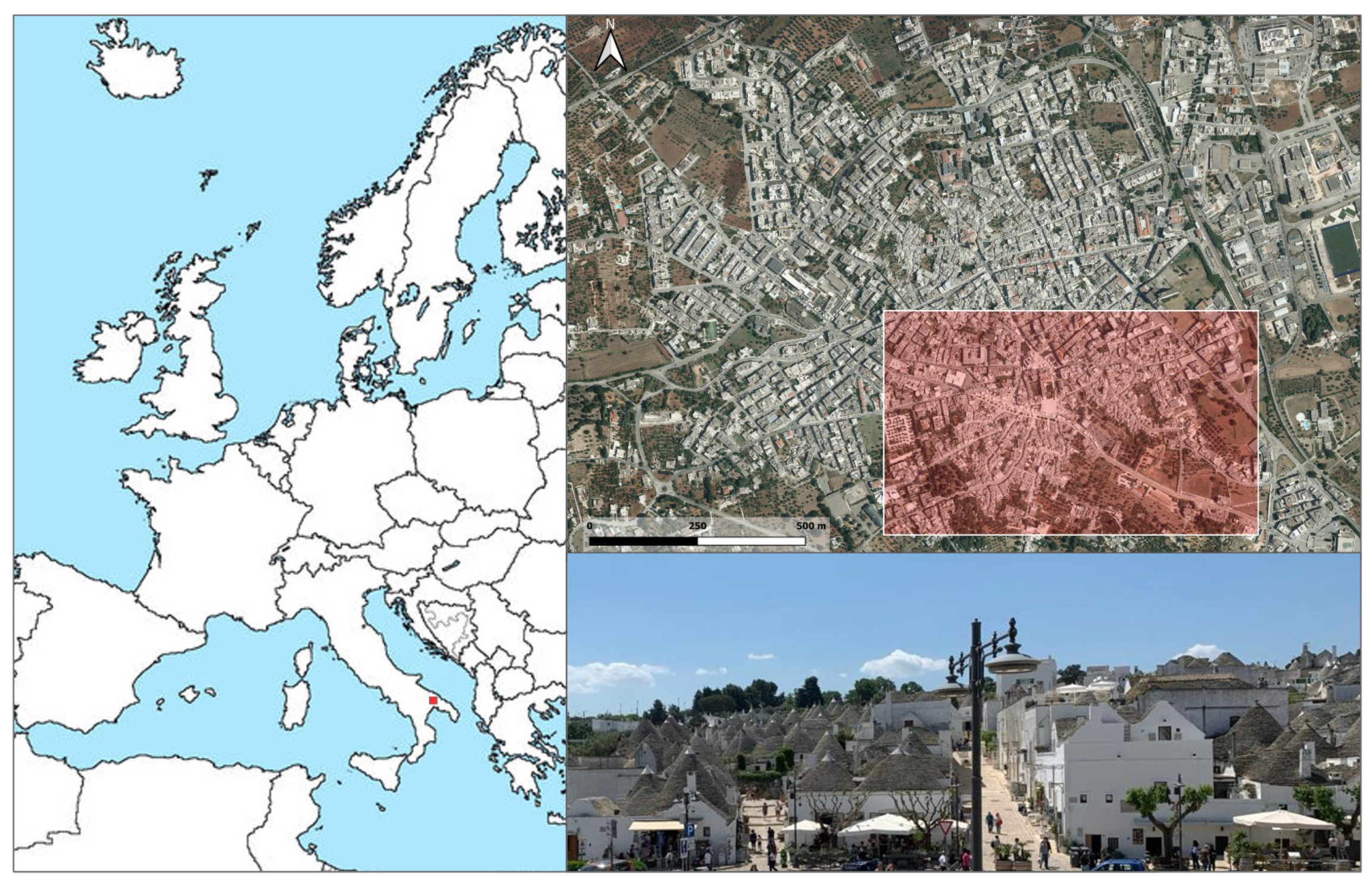
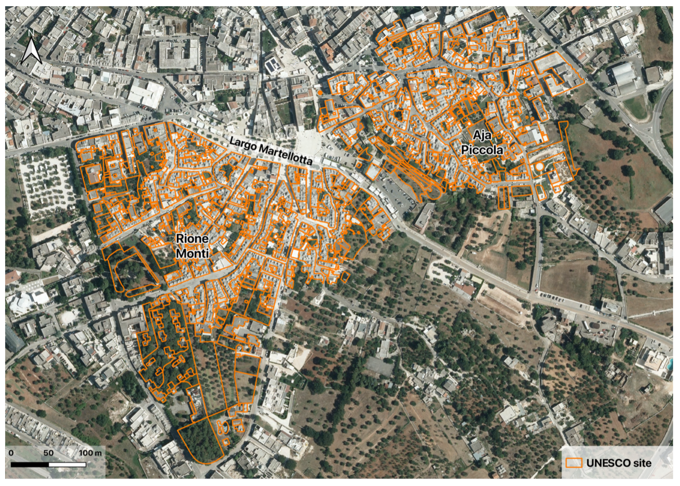
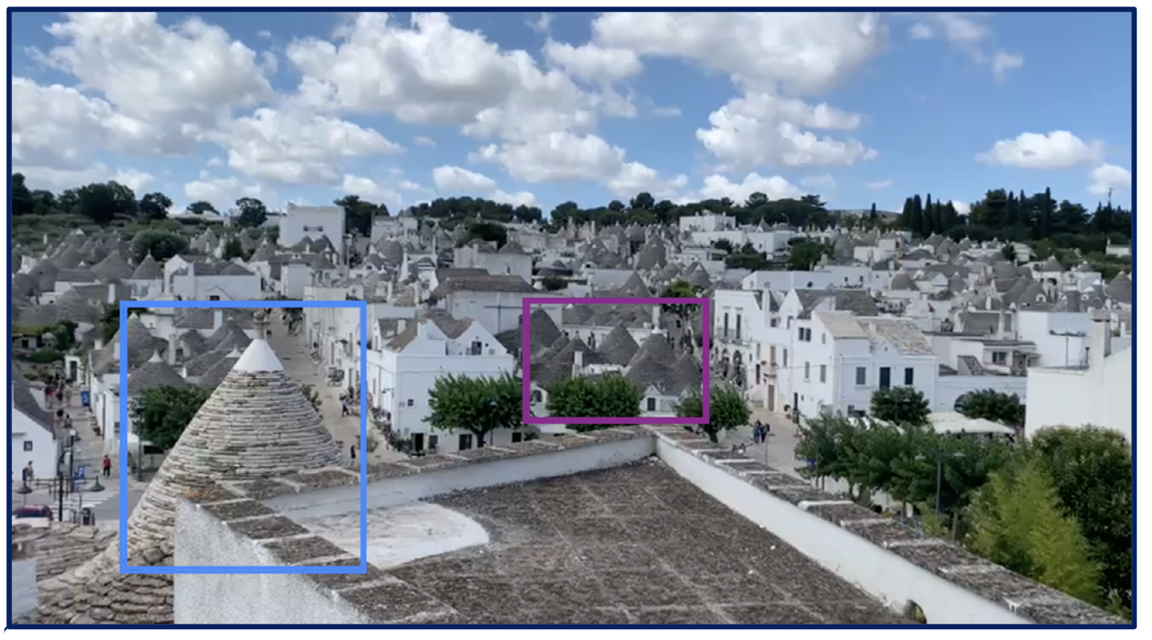
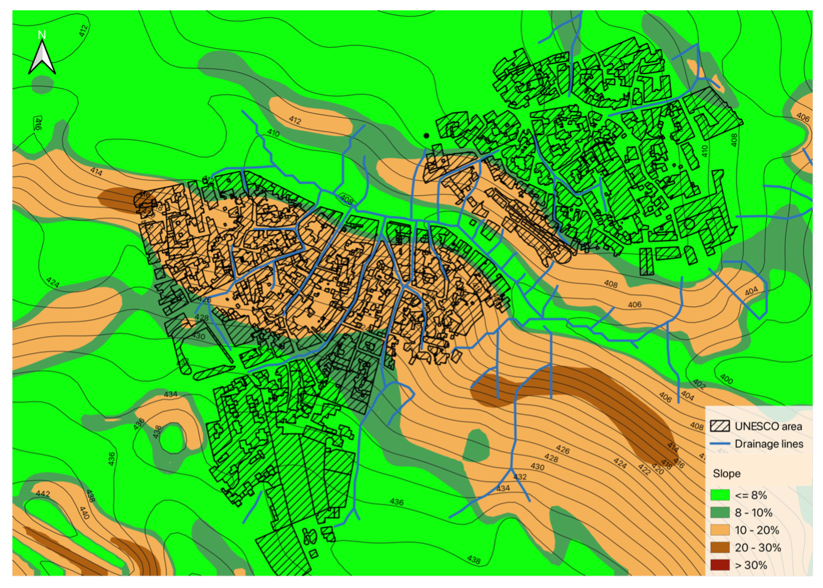
2. Alberobello UNESCO Site

Alberobello is a small town located in the middle of the Apulia Region (40°47′02.62 N; 17°14′14.86 E) in Italy at 428 m a.s.l., inside the Itria Valley, which extends approximately between the cities of Bari, Taranto, and Brindisi [56]. This relatively limited area, containing about 50,000 trulli, shows the highest concentration of this peculiar housing [57]. Although the trulli can be found all along the Itria Valley, Alberobello is the only town that homogeneously features this architectural form, where over 1500 structures spread over an area of 11 hectares are mainly gathered in the quarters of Rione Monti and Aja Piccola, separated by Largo Martellotta (Figure 2).
The trullo is a unique example of architectural heritage with a cone-shaped roof made of stones. Tradition states that they were built without mortar in order to be readily dismantled, thus allowing local farmers to avoid paying taxes for their temporary homes. Dry-stone constructions are commonly found in rural areas throughout Italy, usually in the form of temporary buildings used by farmers and shepherds. This particular building constitutes a development of the prehistoric model of the thòlos. While the thòlos had a funereal use, trulli now address many purposes that range from agricultural activities to housing, hotels, restaurants, and local shops [57,58]. Vernacular architectures are the result of a long construction tradition based on rules of thumb for the assemblage of stones to form a stable structure. Trulli may be composed of a simple room (unitary module) or made of the juxtaposition of several rooms (modules), which are generally added by twinning around the central room (Figure 3).
In particular, the modular construction unit of the trullo has a roughly circular plan, and on the perimeter of this, the very thick dry-stone masonry is set. The high thickness of the masonry, together with the very small number and size of the openings (often only the entrance door and, at most, a very small square window), ensures very high thermal inertia, guaranteeing good preservation of heat inside the building during the winter and the coldest days while attenuating the peaks of the outside temperature in the summer. The load-bearing masonry is completed by a pseudo-dome that forms the roof. This consists of a self-supporting structure without ribs made up of a concentric series of horizontal slabs arranged in increasingly receding steps as one goes upwards, with each complete turn being statically balanced with the lower ones. This inner layer of thicker limestone slabs of local origin, called “chianche”, is completed by the outer layer, constituting the actual roof, in thinner slabs (3–7 cm), called “chiancarelle”, placed on the filling material on the exterior of the dome, with an outward slope in order to facilitate water drainage. In more recent times, however, the construction technique sees the use of sawn stones that are lower in cost, as they are not shaped by an artisan (Figure 4) [57,58,59,60,61,62].
It is well-known that the structural safety of masonry structures is strongly related to their geometry [63,64], and trulli are an example of this statement. An analysis of the collapse mechanisms of several existing and damaged trulli identified the dome as the structural element most vulnerable to external actions. Trulli works as a combination of corbelling in sections and hoop forces in planning.
This peculiar architecture is characterized by a strong mutual relationship between the buildings and the environment, typical of the spontaneous architecture of the Mediterranean Basin. The buildings are an example of sustainable development, with their construction features responding to three fundamental issues: the climate, building materials, and morphology of the territory [65].
The sloping streets (especially in the Rione Monti quarter, Figure 2) featuring a single or double impluvium and the conic shape of the trulli contribute to the ease rainwater drainage. Figure 5 shows the layout of the UNESCO site in context with the contour lines of the site (i.e., zoning into slope areas is color-coded in the legend). The drainage lines evidence the preferential flow paths obtained using a 1 m x 1 m digital surface model (DSM) of the built area. Rain flows tend to accumulate in the area of Largo Martellotta.

3. Materials and Methods

In order to analyze the event that occurred in Alberobello and evaluate the response of the site, a preliminary long-term study was conducted using ERA5 data, as described in Section 3.1. The next phase provided the actual case study analysis, for which a multi-sensor analysis involving both conventional ground-based equipment (Section 3.2), NWP (numerical weather prediction) models (Section 3.3), nonconventional satellite, and ground-based sensors (Section 3.4Section 3.7) was performed.

3.1. ERA5 Model

Europe has large and dense coverage in terms of meteorological sensors, including weather stations, lightning detectors, ground-based GNSS (Global Navigation Satellite System) receivers, and radars; however, the management of all the networks is very scattered within a number of different agencies, and it is extremely difficult to collect all the needed meteorological data at the European level to perform a climatological study. For this reason, in order to define a climatology that is also consistent with the literature mentioned in the introduction, we provided a preliminary large-scale statistical analysis on the ERA5 (Fifth generation of meteorological re-analyses issued by the European Centre for Medium-Range Weather Forecasts) [55] for the period 1980–2020, and an analysis focused on the Apulia region for the period 2012–2022. The re-analyses combine the integrated forecasting system (IFS) model background field with observations to achieve the best estimate of the atmosphere. The ERA5 employed model, covering the whole Earth, uses 137 layers to resolve the atmosphere in the vertical direction and has a horizontal resolution of about 30 km. The ERA5 dataset includes hourly estimates of a wide range of variables, and in the frame of this research, we have employed the convective precipitation (cp) parameter, which represents the accumulated precipitation that falls on the Earth’s surface, which is generated by the convection scheme in the ECMWF-IFS [66]. We used the ERA5 data to extract climatologies for two areas and periods: Europe (lat: 33 N–60 N; lon: 11 W–40 E) from 1980–2020 and Apulia (lat: 39 N–41 N; lon: 14 E–19 E) from 2012–2022. We focused on the cp parameter, which measures the rainfall generated by convection in the ECMWF model. Our analytical approach was as follows:
  • For the European region, we calculated the 90th percentile of cp for each pixel and year. Then, we counted how many times this threshold was exceeded in each pixel and year. We computed the trend of these exceedances over time and normalized this by the maximum value. This gave us a map of areas with increasing or decreasing frequency of convective events. Then, we overlaid this map with the UNESCO site map and identified the sites that were located in areas with positive trends. One of them was Alberobello, which had a slight increase in convective events over the period 1980–2020. In this frame, we found that Alberobello and its surroundings were in an area with a high frequency of intense precipitation events. The range of exceedances was between 60 and 80 percent of the maximum observed. This suggested that Alberobello was prone to heavy rainfall during August in the last decade.
Based on these results, we decided to pay attention to Alberobello and its potential vulnerability to convective precipitation.

3.2. Rain Gauge Data
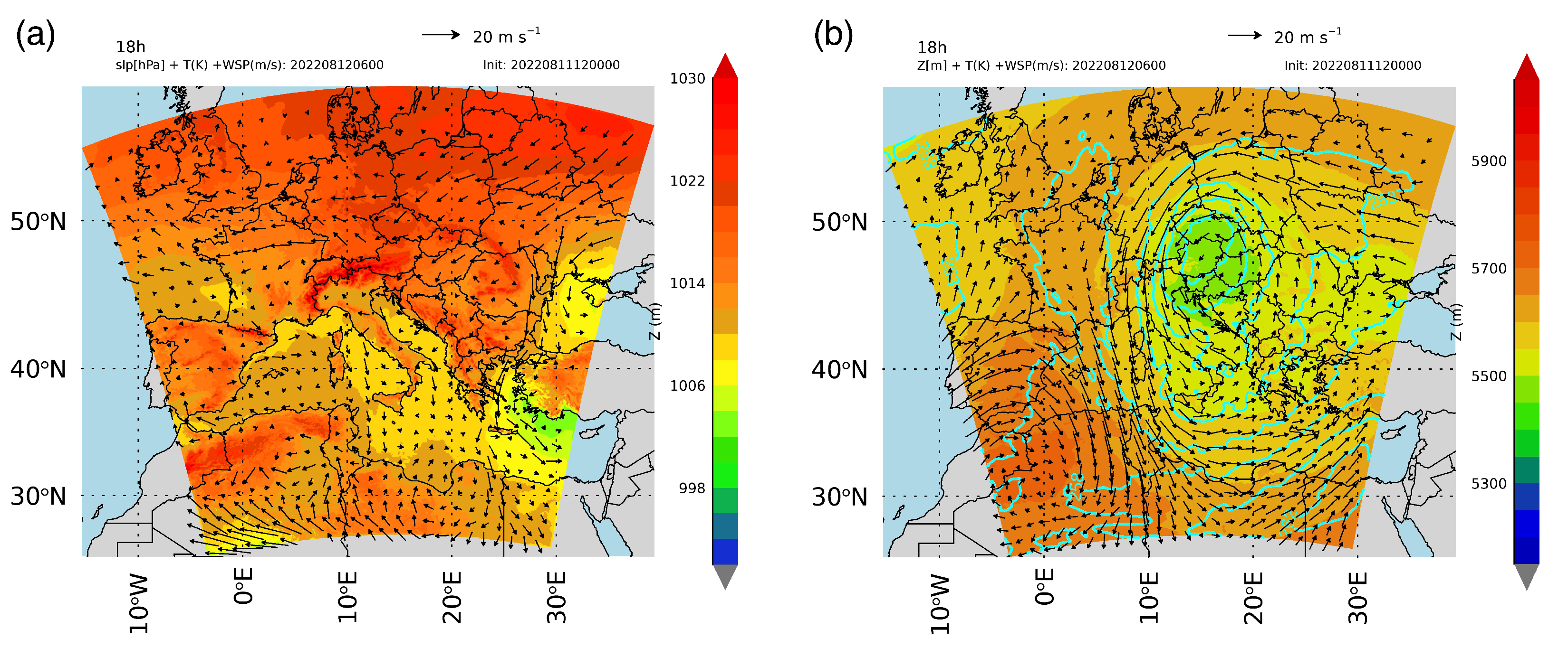
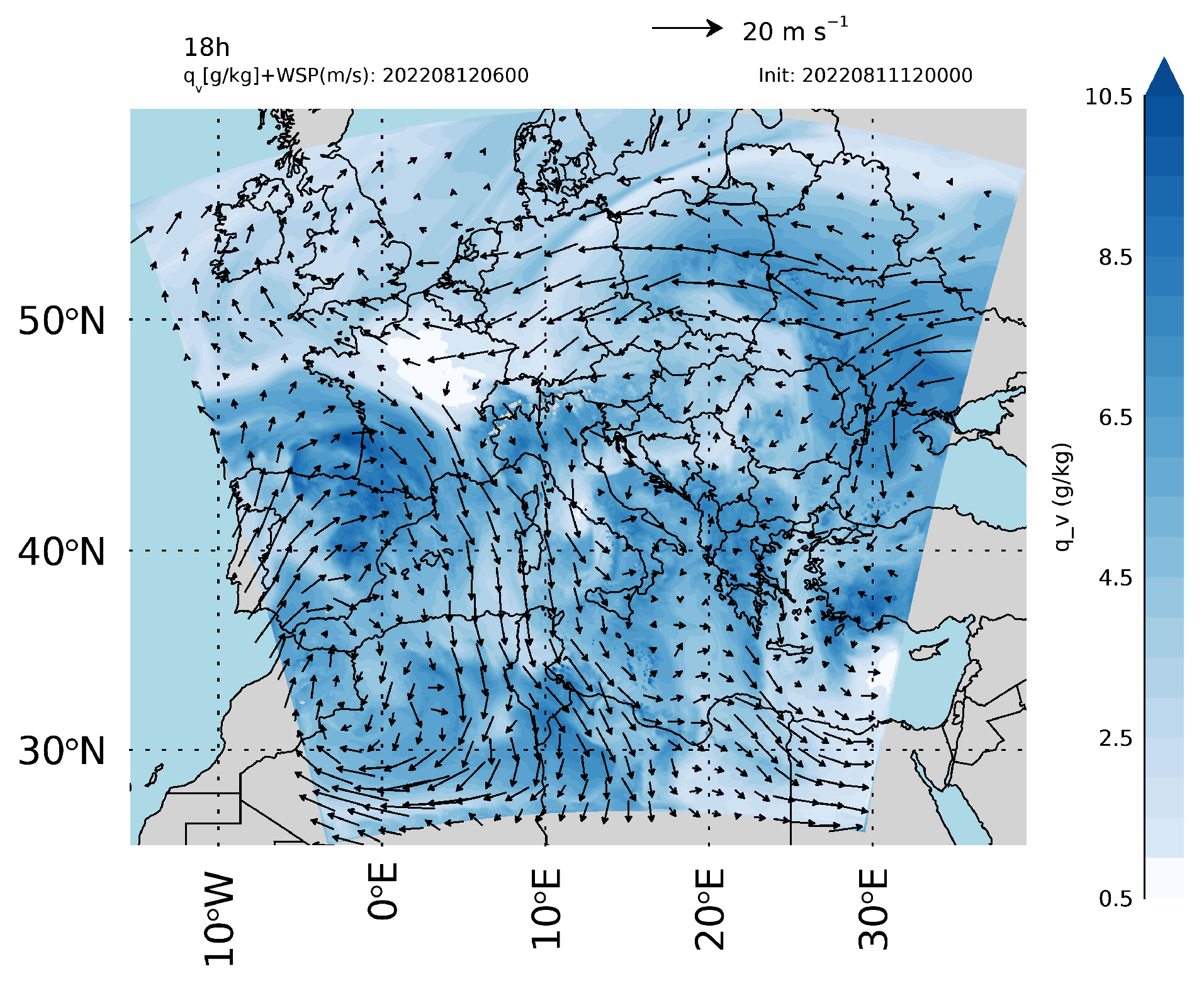
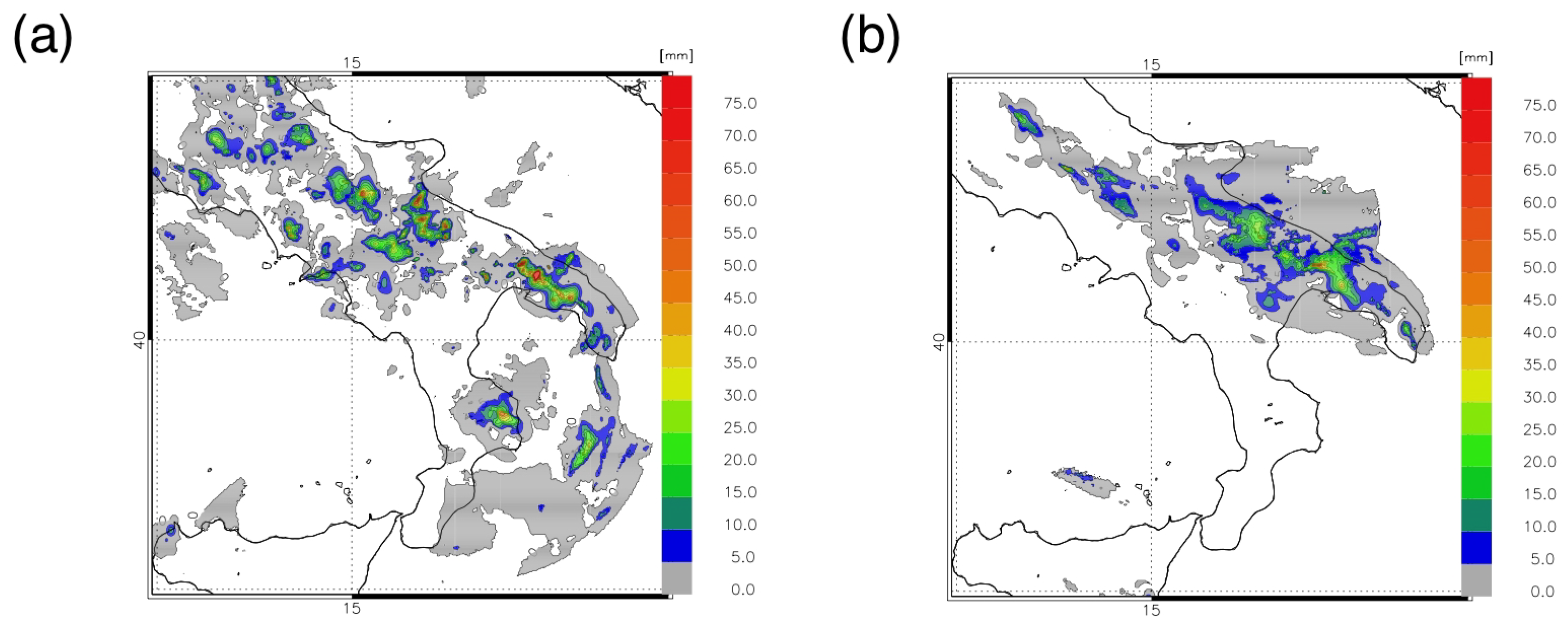
As previously introduced, the case study analysis was performed using a multi-sensor approach. In this context, the rain gauge data provided support in identifying events of potential interest over the selected period of the 12 and 13 August 2022. We used daily data provided by “ARIF Regione Puglia—Agenzia Regionale Attività Irrigue e Forestali” from a rain gauge located in Alberobello (Station: 0PU31 Alberobello—Rete Agrometeorologica Regionale; Co-ordinates: Latitude 40.790558, Longitude 17.233610, Altitude 425 m a.s.l.) and subhourly data provided by “Centro Funzionale Decentrato della Sezione Protezione Civile della Regione Puglia”.

3.3. NWP Models

At this stage, we evaluated whether the NWP models identified the precipitation areas well. The numerical model used in this study is the weather research and forecasting model with advanced WRF dynamics (WRF-ARW), version 4.1.3 [67], in its operational configuration at the CNR-ISAC of Rome. The forecasts were carried out on one single domain with 531 × 531 grid points and 42 vertical levels, with a model top at around 50 hPa. The model domain covers the whole Italian territory with a horizontal grid spacing of 3 km. The physical schemes employed are the following: Thompson et al. microphysics scheme [68], the Mellor-Yamada-Janjic (Eta) TKE scheme for the boundary layer [69], the Dudhia scheme [70], and the Rapid Radiative Transfer Model (RRTM) [71] for short wave and longwave radiation, respectively. No cumulus parameterization was activated. Starting at 12 UTC on the day before the actual day of forecasting, the 3-hourly 0.25° data were provided by the GFS (Global Forecasting System). The forecast uses a very short-term approach, and each forecast lasts 12 h. The first 6 h are used for data assimilation, and the second 6 h are the actual forecast. In these configurations, four WRF runs are needed to forecast a whole day. Lightning and radar reflectivity observations are used for data assimilation. Lightning data are taken from the LINET network (see Section 3.6) and are assimilated by nudging, as discussed in Torcasio et al., 2021 [72], whereas radar reflectivity is assimilated by 3D-Var using the variation scheme provided by the WRF model suite.

3.4. Convection RGB Product

For the days of interest, the convection RGB product (SEVIRI Severe Storms RGB by EUMETSAT [73]), which combines the brightness temperature difference (BTD) between the water vapor channels (WV6.2 and WV7.3, red), the BTD between the infrared channels (IR3.9 and IR10.8, green), and the reflectance difference between the near-infrared and visible channels (NIR1.6 and the VIS0.6, blue) [74], identified the specific time slot marked by the convective event, occurred in the ”Murge” subregion. It is important to note that, in the described color scheme, severe convective storms appear bright yellow because of the near-zero BTD WV6.2-WV7.3 of overshooting cumulonimbus clouds (high red).

3.5. GNSS Data

The timing and intensity of the events have been investigated in-depth through the analysis of lightning and GNSS data. For this aim, the GNSS and lightning data were collected for the town of Noci, about 10 km from Alberobello. This choice was made based on the presence of a GNSS receiver (NOCI; Co-ordinates: Latitude 40.79, Longitude 17.06, and Elevation 437.6 m) in Noci, belonging to INGV-RING (Rete Integrata Nazionale GNSS), and on the representativeness of the data in a 30 km radius [75] centered on the sensor, which therefore includes Alberobello. GNSS data that were processed in PPP (precise point positioning) [76] by goGPS software 1.0 Open Edition [77], and GNSS-PWV (precipitable water vapor) was obtained from GNSS-ZTD (Zenith Total Delay) using (as meteorological data) provided by the GPT model [11,78,79].

3.6. Lightning Data

In order to make the lightning measurements representative of the same area, a circular cutoff with a radius of 30 km and centered on the GNSS receiver co-ordinates, was applied to the available LINET (lightning detection network) data [80]. The LINET network is a ground network that counts more than 500 sensors worldwide, more than 200 of which are located in Europe, with a higher density over central Europe and the western Mediterranean (from 10 W to 35 E and from 30 N to 60 N). For each discharge, the LINET sensors provide the following data: the date and time of occurrence, latitude, longitude, type of discharge (Intra-Cloud (IC) or Cloud-to-Ground(CG)), lightning amperage, and height (for IC discharges).

3.7. Sentinel-1 Data

Nowadays, synthetic aperture radar (SAR) is a standard and reliable instrument to detect floods and their extent [81]. The European Space Agency (ESA) Copernicus Sentinel-1 imagery is commonly used to monitor major floods due to its best ground sampling distance of 10 m. The aim of this part of the study was to understand whether Sentinel-1 imagery can be a valid tool to detect the effects of an event like the one that occurred in Alberobello in August 2022. In particular, we employed the Google Earth Engine (GEE) cloud platform [82] to process the Sentinel-1 ground range detected data [83]. These data are already available within GEE as analysis-ready data: all the required preprocessing steps were performed through the Sentinel-1 Toolbox [83,84] before ingestion within the platform. Specifically, we employed a simplified version of the United Nations (UN) workflow for flood mapping [81], applying it for five years (2019, 2020, 2021, 2022, and 2023) over the same Summer period (before the event: 12 July yeari–12 August yeari, and after the event: 12 August yeari–25 August yeari). The UN workflow implements a change detection approach, which runs according to the following steps [81]: (i) Select Sentinel-1 imagery from before and after the event for the region of interest by considering only the images with vertical/horizontal polarization and collect with descending orbit; (ii) compute the aggregated image (mosaic) for each one of the two periods (before and after); (iii) apply the speckle filter; (iv) compute the degree of change raster as the per-pixel ratio between the after-mosaic and the before-mosaic; (v) apply the predefined threshold of 1.25 to identify the potentially flooded areas; (vi) remove the permanent water, steep areas, and isolated pixels through the use of the JRC Global Surface Water dataset [85], WWF HydroSHEDS DSM [86] and connected component algorithm [87], respectively; from the detected flooded areas; (vii) compute the extent of the potentially flooded area.

4. Results

As was found in the previously described analysis, Alberobello is on the UNESCO list and is located in an area characterized by a slight positive trend; therefore, it is prone to increasing convective rainfall and suitable for use as a case study for analysis. For this purpose, an event characterized by convective precipitation that fell on the area on 12–13 August 2022 was selected for the study. It is interesting to consider the synoptic conditions that led to the intense convective events of 12–13 August 2022. These conditions are derived from a WRF simulation starting at 12:00 UTC on 11 August 2022 and with a horizontal resolution of 5 km. Figure 6 and Figure 7 show the conditions at 06 UTC, several hours before the occurrence of thunderstorms. At the surface, there is a low-pressure area over the eastern Mediterranean; winds over the Adriatic Sea come from the east and are not intense. The conditions at 500 hPa are shown in Figure 6b. Here, the forcing over southern Italy is dominated by low-pressure over the Austria-Hungary border. The movement of air masses brings fresh air over Apulia, determining unstable conditions, and the flow is divergent over south-eastern Italy, favoring the air mass ascent. The water vapor analysis at 750 hPa is shown in Figure 7. As expected for the summer period, the humidity is high over the central Mediterranean because of the evaporation of the sea. Overall, the synoptic conditions favor the development of afternoon thunderstorms because cool air masses are advecting over Apulia at mid-tropospheric levels, whereas solar heating destabilizes the planetary boundary layer in the afternoon. Finally, the abundance of water vapor feeds the thunderstorm with latent heat energy once it develops.
Analysis of rainfall data over the area shows that August 2022 was essentially dry with the exception of one occurrence of rainfall on 12–13 August. Figure 8a,b show the observed precipitation of the rain gauge/radar composite between 12 and 15 UTC on 12 August and between 15 and 18 UTC on 13 August. On 12 August, the rainfall in Alberobello and around the UNESCO site was greater than 75 mm/3 h. These amounts were enough to cause flash floods in some sites around Alberobello.
The other times on both days had low rainfall, and the main precipitation was associated with the destabilization of the PBL caused by the solar heating in Figure 8a,b, as confirmed by the satellite product (i.e., convection RGB product below), showing the event to have a relatively short duration. The NWP models and, in particular, the WRF V4.1.3 model (for both days) identified the precipitation areas and intensities around Alberobello well (Figure 9a,b).
For the days of interest and at the areas identified, the Convection RGB product images [74], combining information about cloud thickness and the presence of ice particles, were exported (Figure 10).
The pictures in Figure 10 show a rather severe convective storm, with the shape tending toward yellow in Figure 10a, and overshooting Cb clouds (red shapes) in Figure 10a,b. On both days, the period of greatest convection is in the early afternoon. This is confirmed by the analysis of lightning and GNSS data, which identified the timing and intensity of the events in more detail (Figure 11).
As can be seen in Figure 11, two main peaks can be detected on 12 and 13 August in the early afternoon. In both cases, there is a clear correlation between the two datasets, which confirms how the increase in electrical discharge is strongly linked to the increase in water vapor.
The results of the analysis of the Sentinel-1 data are reported in Table 1 and in Figure 12.
The results highlight the great intensity of the extreme event under investigation: in the year of the extreme event (2022, Table 1), the extent of the potentially flooded areas is indeed significantly greater (one order of magnitude) than in the other years considered in the analysis, whereby the potentially flooded areas are practically not existent, as expected. Moreover, the potentially flooded areas identified in 2022 are located mainly in the rural areas around Alberobello, whereas the trulli district is not affected by any flooding phenomena (Figure 12).

5. Discussion

As obtained via ERA5 data processing, an increasing trend in the occurrence of extreme events has been generally observed for many areas in the past decades. The choice of the study area of Alberobello for the analysis reported so far is closely related to the presence of the UNESCO site in the territory and the exposure of it and the surrounding areas to extreme events. These areas are, therefore, placed in a position of potential vulnerability, and addressing which targeted risk reduction actions are required is necessary. In general, the Mediterranean Basin is characterized by the presence of historical buildings, many of which are a typical expression of vernacular architecture, representing rare examples of sustainable buildings erected in response to the geography of a land, the history of its people, and the availability of materials. One such case is properly represented by the trulli of Alberobello, and the analysis reported so far shows that these historic buildings have clear, resilient features. Attention must be focused mainly on the constructive techniques and their recovery aimed not only at conservative restoration and reuse but also at their climate change response. Trulli are an example of sustainable development, with their construction features responding to three fundamental issues: the climate, building materials, and morphology of the territory. In fact, these vernacular approaches have the potential for further development and could be adapted in response to contemporary needs in areas with specific topographical characteristics and vulnerability on the basis of appropriate technology and using locally available materials and knowledge. The Alberobello site not only helps itself but also highlights how prevention can be conducted through preparedness and actions aimed at maintaining the effectiveness of structures in line with the actions foreseen by the United Nations Sendai Framework for Disaster Risk Reduction 2015–2030. Today, the preservation of traditions and the recovery of ancient techniques are, unfortunately, at risk of disappearing, yet they show qualities of sustainability and adaptation to the territory and to the dominant climate of the surroundings characterized by increasingly frequent environmental changes. This case study, wherein the trulli were built in the Alberobello land that, in the past decades, has been increasingly hit by extreme weather phenomena, shows how evident it is that lessons must be learned from historical vernacular architecture and its adaptation in the modern context, subject to constant challenges and changes. Buildings should be climate responsive, which means that their design should aim to work with nature and not against it. In order to underline this topic, the analysis identified the characteristics of the identified meteorological event by using a multi-sensor approach, and the strengths of the site under consideration were allowed to emerge. As was found in the results of the Google Earth Engine analysis of Sentinel 1B data, after the meteorological event, which occurred on 12 and 13 August 2022, it was observed that the area on which the trulli stand and the trulli themselves did not suffer flooding and damage, as was the case in the neighboring areas, where floods hit population centers and crop damage occurred in the countryside (e.g., [88,89]). Vernacular architecture, therefore, can be considered as a heritage category for localizing the management of climate change. Only by learning, understanding, and appreciating the past is it possible to design and build sustainably while reducing the risks from environmental conditions in a changing climate.

6. Conclusions

This work demonstrates how the UNESCO site of Alberobello in the Apulia region (Italy) represents a remarkable example of cultural heritage resilience to extreme weather events based on the vernacular architecture of the trulli. In contrast to neighboring areas that suffered flooding and damage from an intense thunderstorm that occurred on 12 and 13 August 2022, Alberobello and its trulli showed a positive response to the event, as evidenced by the data from meteorological sensors and field observations. This case study illustrates how this specific kind of architecture (peculiar geometry, assemblage of stones to form a stable structure of a circular plan, a cone-shaped roof, and an outward slope to facilitate water drainage) can contribute to natural risk reduction and adaptation, which is in line with the United Nations Sendai Framework for Disaster Risk Reduction 2015–2030. A key element in resilience is learning, which takes place in many ways and forms and in many contexts. It is a dynamic and ongoing process by which a society or nation perceives, assesses, and acts on harmful experiences or past mistakes in purposeful ways [49]. It also highlights the importance of safeguarding and mobilizing cultural heritage as a resource for coping with climate change challenges, respecting and perpetuating the ancient building techniques that arose for a specific territory. This work highlights the need to explore how to preserve and enhance heritage in a changing climate and how to learn from its lessons for designing and building sustainably, as suggested by the main achievements and implications of this study summarized below:
  • A detailed description of the UNESCO site of Alberobello and its historical, cultural, and architectural value allowed for greater awareness about its exposure and vulnerability to extreme weather events.
  • A climate analysis of the area for recent years using ERA5 model data and identifying the trends and anomalies in temperature and precipitation opens up considerations of climate change-related effects in the Mediterranean Basin;
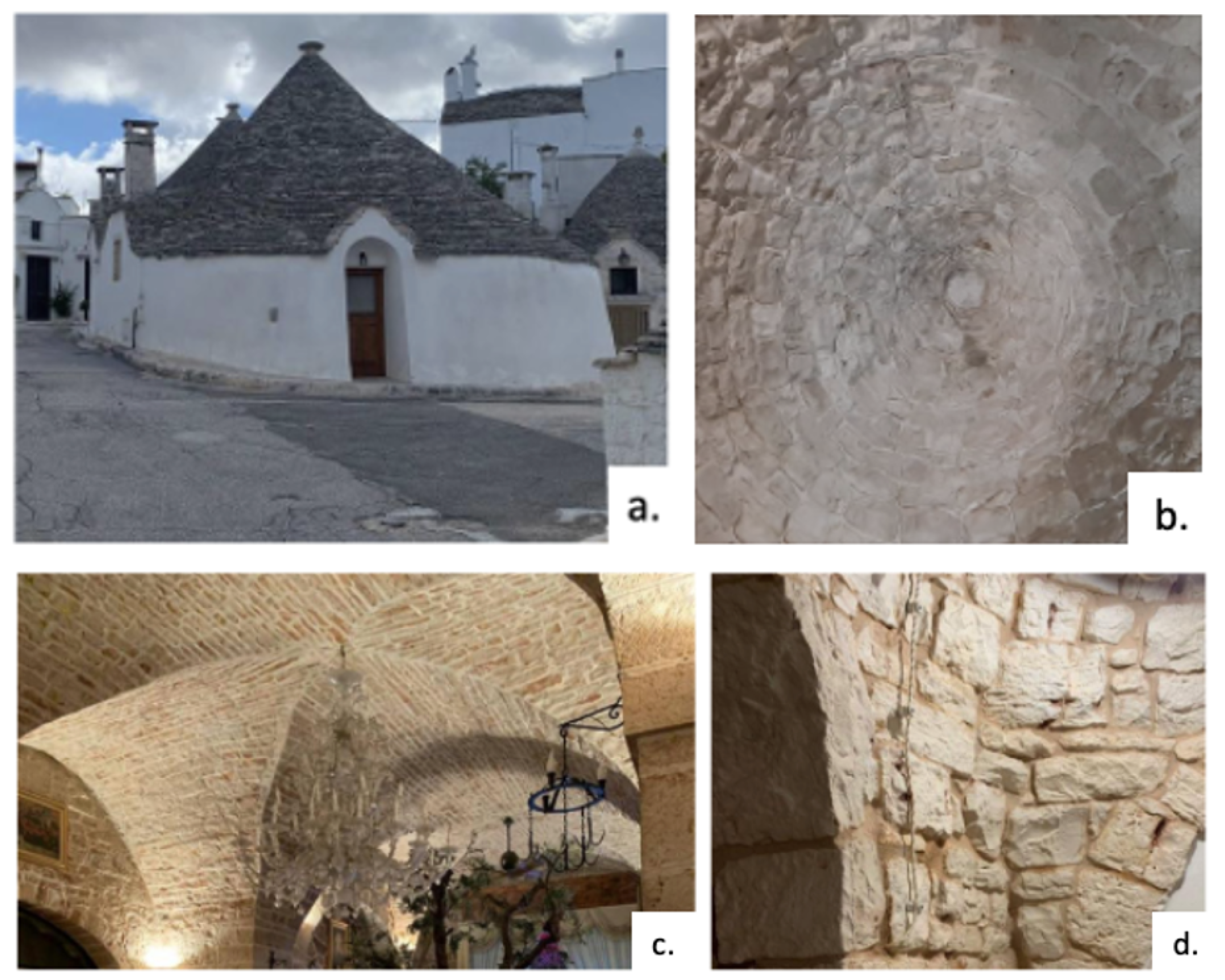
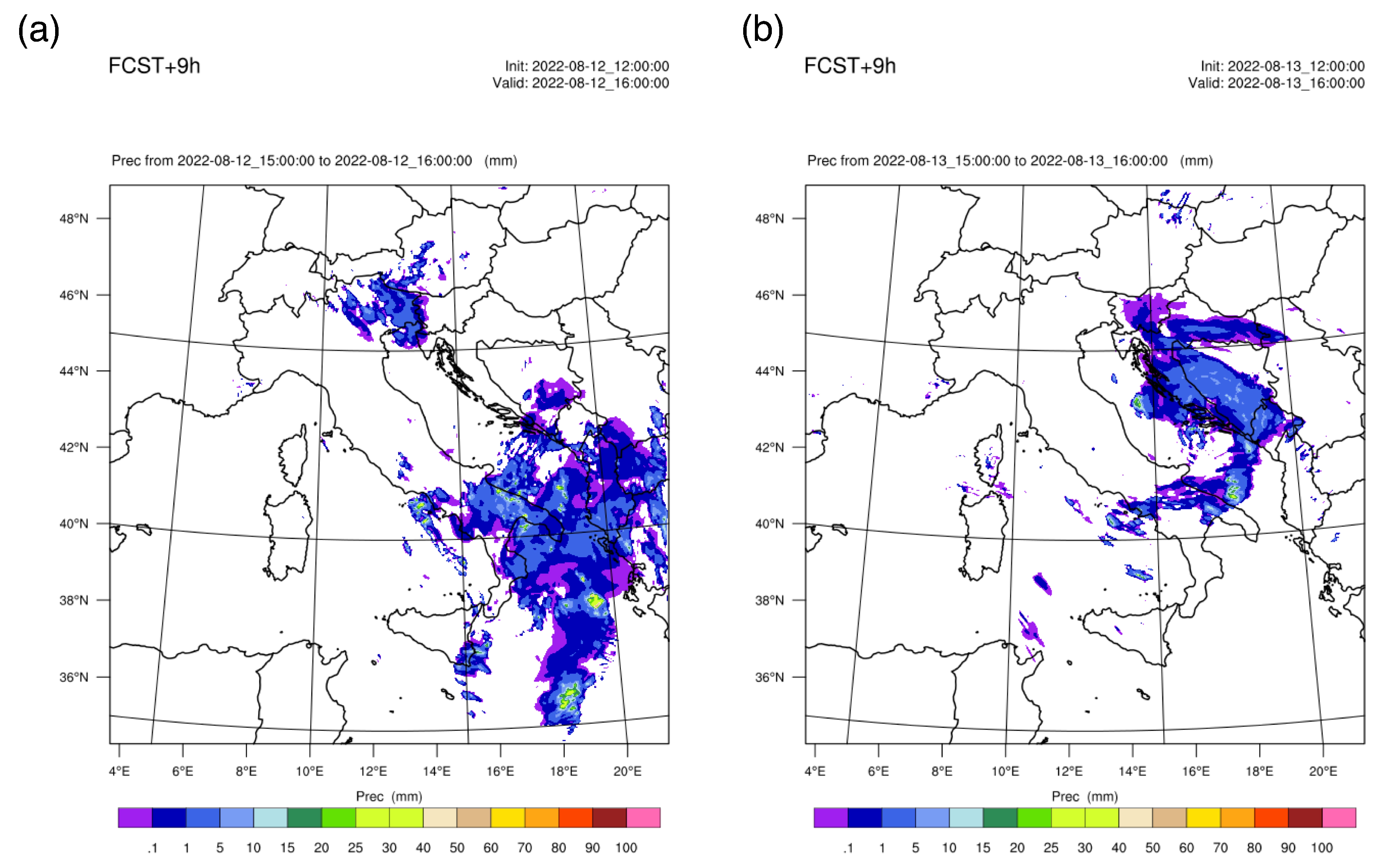
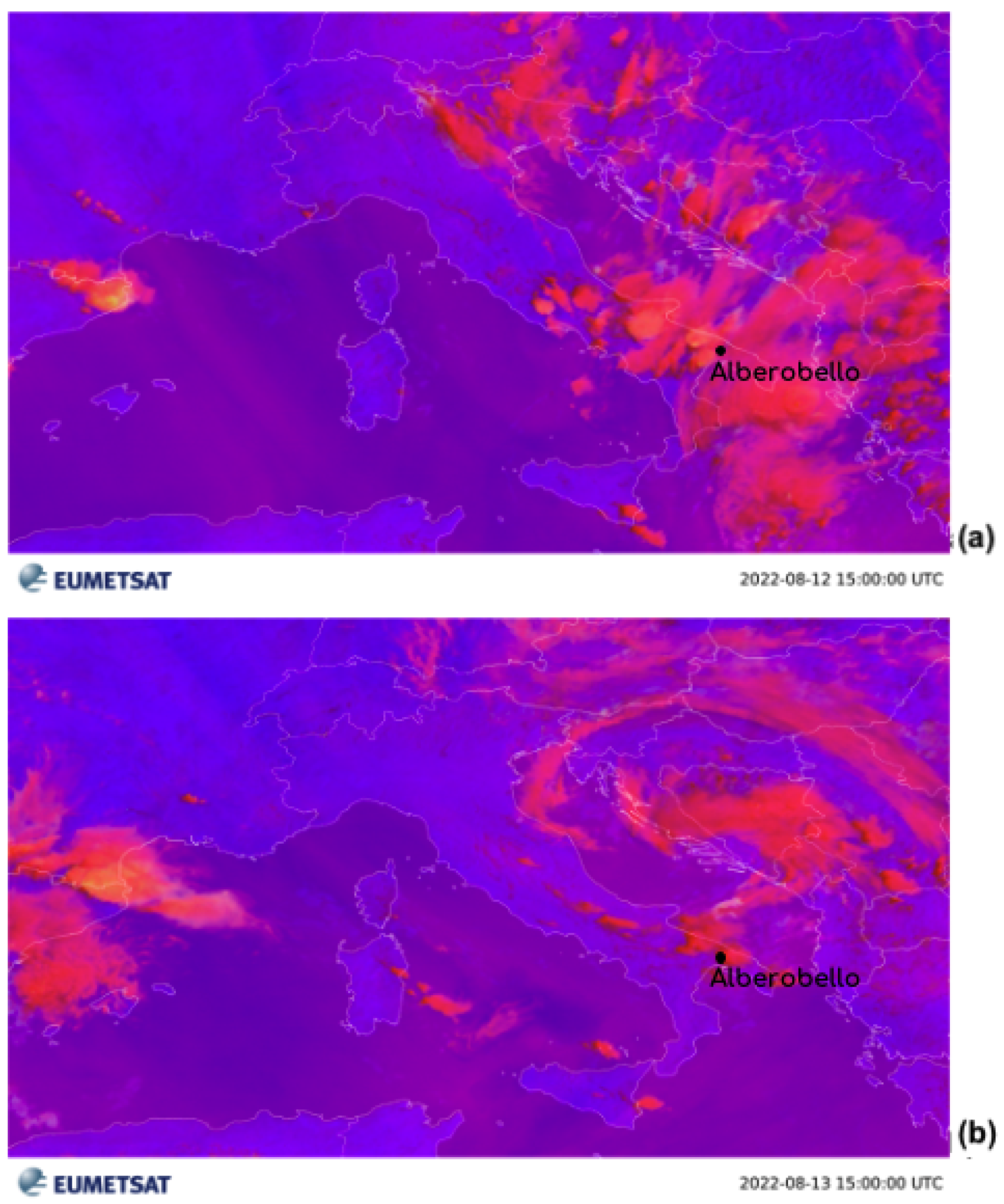
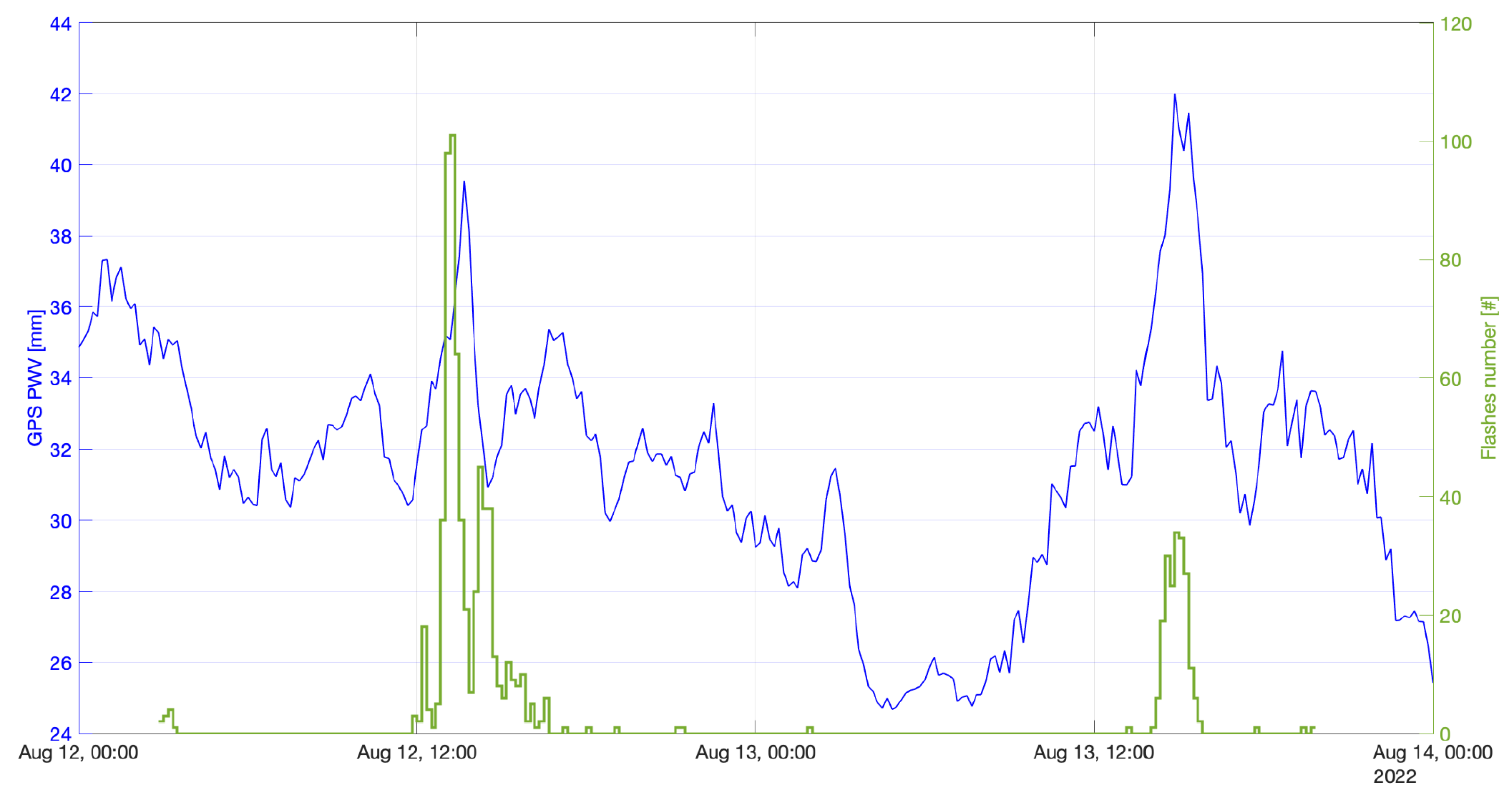
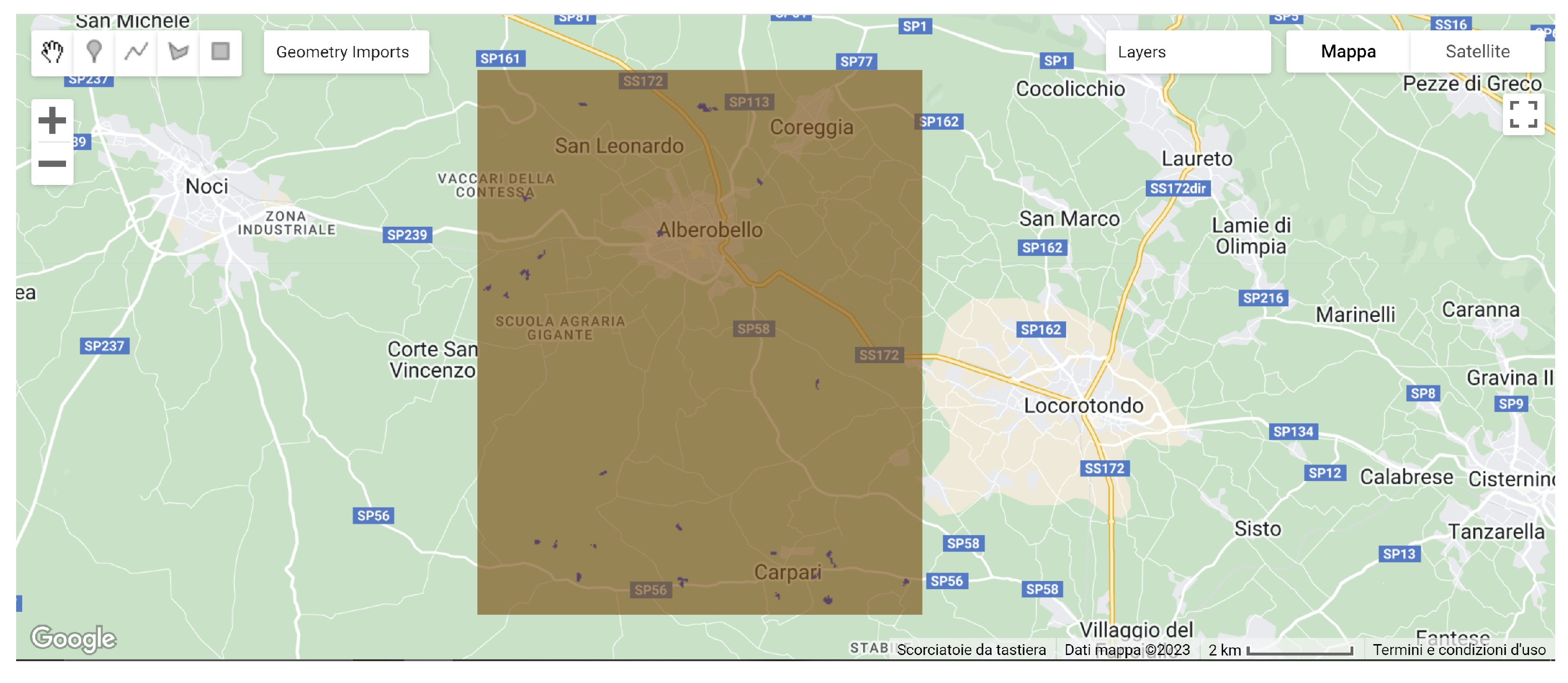
  • Meteorological conditions impacted the analysis, especially the intense thunderstorm that occurred on 12 and 13 August 2022 over the Alberobello site and its surroundings; by using data from the NWP model, rain gauges, the Google Earth Engine analysis of Sentinel 1B data, the GNSS stations, and field observations, the resilience of the trulli was made evident when compared to the surrounding areas;
  • The paper illustrates how trulli represent an example of a sustainable building that has adapted to the geography, history, and material availability of the Mediterranean Basin, showing qualities of low environmental impact, thermal efficiency, durability, and adaptability;
  • The links between the case study and Goal 13 of the Sustainable Development Goals (SDGs), which aims to take urgent action to combat climate change and its impacts, as well as the importance of the concept of community resilience, as proposed by Haque and Haque (2022) [50], which provides insights into how local communities address the challenges of climate change using indigenous knowledge, social learning, innovative adaptation, and participatory governance, are evident;
  • In summary, the work suggests that further studies are needed to explore how to preserve and enhance this heritage in a changing climate and how to draw lessons for sustainable design and construction. It also indicates that the concepts of sustainability and sustainable development need to be interpreted and applied in relation to the context and specific needs of each system.
Moreover, although the concepts of sustainability and sustainable development have acquired great relevance in scientific research, these two concepts are immersed in debates regarding their meaning and their possibilities for application to real systems [90]. In this work, the first step was to interpret the concept of sustainability and its components, particularly the environmental type, focusing on its impact on the analyzed system. In fact, although the trulli are still standing today, in the last decades of the 20th century, the culture of recovering and reusing ancient buildings, which characterizes the Murgia Plateau, has spread widely to make them attractive not only to mass tourism but also to high-level permanent tourism that has led foreign investors (mostly from England) to purchase farms of considerable dimensions, often moving there for several months a year. In addition to this, focus was paid to the vulnerabilities and weaknesses and on the subsequent risks related to the changes in environmental dynamics, particularly intense weather events that can be characterized by multi-sensor approaches. This integrated approach is mainly aimed at understanding the phenomenon in its complexity and at rethinking the concept itself of maintaining and protecting the cultural asset in a sustainable way.

Author Contributions

Conceptualization, A.M., F.P. and S.D.; methodology, A.M., F.P., A.S., S.F., R.C.T., R.B. and S.D.; software, A.M., A.S. and R.C.T.; validation, A.M., A.S., S.F. and R.C.T.; formal analysis, A.M., A.S., S.F., R.C.T., R.R. and R.B.; resources, S.D.; data curation, A.M., F.P., A.S., S.F., R.C.T., R.R., R.B. and S.D.; writing—original draft preparation, A.M. and F.P.; writing—review and editing, A.M., F.P., A.S., S.F., R.R. and R.B.; supervision, F.P., A.M. and S.D.; funding acquisition, S.D. All authors have read and agreed to the published version of the manuscript.

Funding

This research received no external funding.

Institutional Review Board Statement

Not applicable.

Informed Consent Statement

Not applicable.

Data Availability Statement

LINET data were provided by Nowcast GmbH (https://www.nowcast.de/, accessed on 24 October 2022). Rain gauge data were provided by “ARIF Regione Puglia—Agenzia Regionale Attività Irrigue e Forestali” and “Centro Funzionale Decentrato della Sezione Protezione Civile della Regione Apulia Region”. EUMETSAT products are available at https://view.eumetsat.int/productviewer?v=default (accessed on 24 October 2022). Sentinel-1 Data are available at https://scihub.copernicus.eu (accessed on 24 October 2022) GNSS and NWP model output can be requested to the corresponding author.

Acknowledgments

The authors would like to thank “ARIF Regione Puglia—Agenzia Regionale Attività Irrigue e Forestali” and “Centro Funzionale Decentrato della Sezione Protezione Civile della Regione Apulia Region” for providing rain gauge data. LINET data were provided by Nowcast GmbH (https://www.nowcast.de/, accessed on 24 October 2022) within a scientific agreement between H.D. Betz and the Satellite Meteorological Group of CNR-ISAC in Rome.

Conflicts of Interest

The authors declare no conflict of interest.

References

  1. Puglia, R. Ortophoto 2019. Available online: www.sit.puglia.it (accessed on 1 October 2023).
  2. O’Brien, G.; O’keefe, P.; Rose, J.; Wisner, B. Climate change and disaster management. Disasters 2006, 30, 64–80. [Google Scholar] [PubMed]
  3. Sesana, E.; Gagnon, A.S.; Bertolin, C.; Hughes, J. Adapting cultural heritage to climate change risks: Perspectives of cultural heritage experts in Europe. Geosciences 2018, 8, 305. [Google Scholar]
  4. Dastgerdi, A.S.; Sargolini, M.; Pierantoni, I. Climate change challenges to existing cultural heritage policy. Sustainability 2019, 11, 5227. [Google Scholar]
  5. Sardella, A.; Palazzi, E.; von Hardenberg, J.; Del Grande, C.; De Nuntiis, P.; Sabbioni, C.; Bonazza, A. Risk mapping for the sustainable protection of cultural heritage in extreme changing environments. Atmosphere 2020, 11, 700. [Google Scholar] [CrossRef]
  6. Sesana, E.; Gagnon, A.S.; Ciantelli, C.; Cassar, J.; Hughes, J.J. Climate change impacts on cultural heritage: A literature review. Wiley Interdiscip. Rev. Clim. Chang. 2021, 12, e710. [Google Scholar]
  7. Mascitelli, A.; Prestileo, F.; Stella, E.M.; Aruffo, E.; López Campos, L.I.; Federico, S.; Torcasio, R.C.; Corsi, A.; Di Carlo, P.; Dietrich, S. Impact of Climate Change on the “Trabocchi Coast”(Italy): The Trabocco Turchino Case Study. Sustainability 2023, 15, 10880. [Google Scholar]
  8. D’Adderio, L.P.; Pazienza, L.; Mascitelli, A.; Tiberia, A.; Dietrich, S. A Combined IR-GPS satellite analysis for potential applications in detecting and predicting lightning activity. Remote Sens. 2020, 12, 1031. [Google Scholar]
  9. Laviola, S.; Levizzani, V.; Ferraro, R.R.; Beauchamp, J. Hailstorm detection by satellite microwave radiometers. Remote Sens. 2020, 12, 621. [Google Scholar] [CrossRef]
  10. Marra, A.; Porcù, F.; Baldini, L.; Petracca, M.; Casella, D.; Dietrich, S.; Mugnai, A.; Sanò, P.; Vulpiani, G.; Panegrossi, G. Observational analysis of an exceptionally intense hailstorm over the Mediterranean area: Role of the GPM Core Observatory. Atmos. Res. 2017, 192, 72–90. [Google Scholar]
  11. Mascitelli, A.; Petracca, M.; Puca, S.; Realini, E.; Gatti, A.; Biondi, R.; Anesiadou, A.; Brocca, L.; Vulpiani, G.; Torcasio, R.C.; et al. Multi-Sensor Data Analysis of an Intense Weather Event: The July 2021 Lake Como Case Study. Water 2022, 14, 3916. [Google Scholar]
  12. Cassar, M.; Pender, R. The impact of climate change on cultural heritage: Evidence and response. In ICOM Committee for Conservation, Proceedings of the 14th Triennial Meeting, The Hague, The Netherlands, 12–16 September 2005; James & James: London, UK, 2005; Volume 2, pp. 610–616. [Google Scholar]
  13. Hoeppe, P. Trends in weather related disasters–Consequences for insurers and society. Weather Clim. Extrem. 2016, 11, 70–79. [Google Scholar] [CrossRef]
  14. Rädler, A.T.; Groenemeijer, P.H.; Faust, E.; Sausen, R.; Púčik, T. Frequency of severe thunderstorms across Europe expected to increase in the 21st century due to rising instability. NPJ Clim. Atmos. Sci. 2019, 2, 30. [Google Scholar]
  15. Sander, J.; Eichner, J.; Faust, E.; Steuer, M. Rising variability in thunderstorm-related US losses as a reflection of changes in large-scale thunderstorm forcing. Weather Clim. Soc. 2013, 5, 317–331. [Google Scholar] [CrossRef]
  16. Rädler, A.T.; Groenemeijer, P.; Faust, E.; Sausen, R. Detecting severe weather trends using an additive regressive convective hazard model (AR-CHaMo). J. Appl. Meteorol. Climatol. 2018, 57, 569–587. [Google Scholar]
  17. Mascitelli, A.; Federico, S.; Fortunato, M.; Avolio, E.; Torcasio, R.C.; Realini, E.; Mazzoni, A.; Transerici, C.; Crespi, M.; Dietrich, S. Data assimilation of GPS-ZTD into the RAMS model through 3D-Var: Preliminary results at the regional scale. Meas. Sci. Technol. 2019, 30, 055801. [Google Scholar] [CrossRef]
  18. Mascitelli, A.; Federico, S.; Torcasio, R.; Dietrich, S. Assimilation of GPS Zenith Total Delay estimates in RAMS NWP model: Impact studies over central Italy. Adv. Space Res. 2021, 68, 4783–4793. [Google Scholar]
  19. Biondi, R.; Chkeir, S.; Anesiadou, A.; Mascitelli, A.; Realini, E.; Nisi, L.; Cimarelli, C. Multivariate Multi-Step Convection Nowcasting with Deep Neural Networks: The Novara Case Study. In Proceedings of the IGARSS 2022-2022 IEEE International Geoscience and Remote Sensing Symposium, Kuala Lumpur, Malaysia, 17–22 July 2022; pp. 6598–6601. [Google Scholar]
  20. Chkeir, S.; Anesiadou, A.; Mascitelli, A.; Biondi, R. Nowcasting extreme rain and extreme wind speed with machine learning techniques applied to different input datasets. Atmos. Res. 2023, 282, 106548. [Google Scholar]
  21. Merino, A.; López, L.; Sánchez, J.; García-Ortega, E.; Cattani, E.; Levizzani, V. Daytime identification of summer hailstorm cells from MSG data. Nat. Hazards Earth Syst. Sci. 2014, 14, 1017–1033. [Google Scholar]
  22. Punge, H.; Bedka, K.; Kunz, M.; Werner, A. A new physically based stochastic event catalog for hail in Europe. Nat. Hazards 2014, 73, 1625–1645. [Google Scholar]
  23. Van den Besselaar, E.; Klein Tank, A.; Buishand, T. Trends in European precipitation extremes over 1951–2010. Int. J. Climatol. 2013, 33, 2682–2689. [Google Scholar] [CrossRef]
  24. Maraun, D. When will trends in European mean and heavy daily precipitation emerge? Environ. Res. Lett. 2013, 8, 014004. [Google Scholar]
  25. Scoccimarro, E.; Villarini, G.; Vichi, M.; Zampieri, M.; Fogli, P.G.; Bellucci, A.; Gualdi, S. Projected changes in intense precipitation over Europe at the daily and subdaily time scales. J. Clim. 2015, 28, 6193–6203. [Google Scholar]
  26. Ban, N.; Schmidli, J.; Schär, C. Heavy precipitation in a changing climate: Does short-term summer precipitation increase faster? Geophys. Res. Lett. 2015, 42, 1165–1172. [Google Scholar]
  27. Rajczak, J.; Pall, P.; Schär, C. Projections of extreme precipitation events in regional climate simulations for Europe and the Alpine Region. J. Geophys. Res. Atmos. 2013, 118, 3610–3626. [Google Scholar]
  28. Stott, P. How climate change affects extreme weather events. Science 2016, 352, 1517–1518. [Google Scholar] [CrossRef]
  29. O’Gorman, P.A. Precipitation extremes under climate change. Curr. Clim. Chang. Rep. 2015, 1, 49–59. [Google Scholar]
  30. Romero, R.; Emanuel, K. Medicane risk in a changing climate. J. Geophys. Res. Atmos. 2013, 118, 5992–6001. [Google Scholar] [CrossRef]
  31. Cavicchia, L.; von Storch, H.; Gualdi, S. Mediterranean tropical-like cyclones in present and future climate. J. Clim. 2014, 27, 7493–7501. [Google Scholar]
  32. Walsh, K.; Giorgi, F.; Coppola, E. Mediterranean warm-core cyclones in a warmer world. Clim. Dyn. 2014, 42, 1053–1066. [Google Scholar]
  33. Romero, R.; Emanuel, K. Climate change and Hurricane-like extratropical cyclones: Projections for North Atlantic polar lows and medicanes based on CMIP5 models. J. Clim. 2017, 30, 279–299. [Google Scholar]
  34. Romera, R.; Gaertner, M.Á.; Sánchez, E.; Domínguez, M.; González-Alemán, J.J.; Miglietta, M.M. Climate change projections of medicanes with a large multi-model ensemble of regional climate models. Glob. Planet. Chang. 2017, 151, 134–143. [Google Scholar]
  35. Scicchitano, G.; Scardino, G.; Monaco, C.; Piscitelli, A.; Milella, M.; De Giosa, F.; Mastronuzzi, G. Comparing impact effects of common storms and Medicanes along the coast of south-eastern Sicily. Mar. Geol. 2021, 439, 106556. [Google Scholar]
  36. Coletta, V.; Mascitelli, A.; Bonazza, A.; Ciarravano, A.; Federico, S.; Prestileo, F.; Torcasio, R.C.; Dietrich, S. Multi-instrumental analysis of the extreme meteorological event occurred in matera (Italy) on November 2019. In Computational Science and Its Applications, Proceedings of the ICCSA 2021: 21st International Conference, Cagliari, Italy, 13–16 September 2021; Proceedings, Part VIII; Springer: Berlin/Heidelberg, Germany, 2021; pp. 140–154. [Google Scholar]
  37. Gabriele, M. Dectecting and mapping flash flooding with synthetic aperture radar (SAR) satellite data: The Metaponto plain cultural landscape case study. In Proceedings of the the ARQUEOLÓGICA 2.0-9th International Congress & 3rd GEORES-GEOmatics and pREServation, Valencia, Spain, 26–28 April 2021; pp. 212–222. [Google Scholar]
  38. Zhang, W.; Villarini, G.; Scoccimarro, E.; Napolitano, F. Examining the precipitation associated with medicanes in the high-resolution ERA-5 reanalysis data. Int. J. Climatol. 2021, 41, E126–E132. [Google Scholar] [CrossRef]
  39. Prestileo, F.; Mascitelli, A.; Meli, G.; Petracca, M.; Giorgi, C.; Melfi, D.; Puca, S.; Dietrich, S. Resilience of Cultural Heritage in Extreme Weather Conditions: The Case of the UNESCO Villa Romana del Casale Archaeological Site’s Response to the Apollo Medicane in October 2021. In Computational Science and Its Applications, Proceedings of the ICCSA 2022 Workshops, Malaga, Spain, 4–7 July 2022; Proceedings, Part IV; Springer: Berlin/Heidelberg, Germany, 2022; pp. 511–526. [Google Scholar]
  40. Sonnessa, A.; di Lernia, A.; Oscar Nitti, D.; Nutricato, R.; Tarantino, E.; Cotecchia, F. Integration of multi-sensor MTInSAR and ground-based geomatic data for the analysis of non-linear displacements affecting the urban area of Chieuti, Italy. Int. J. Appl. Earth Obs. Geoinf. 2023, 117, 103194. [Google Scholar] [CrossRef]
  41. Bertolin, C.; Perry, J. World Heritage and Climate Change; MDPI: Basel, Switzerland, 2020. [Google Scholar]
  42. Púčik, T.; Groenemeijer, P.; Rädler, A.T.; Tijssen, L.; Nikulin, G.; Prein, A.F.; van Meijgaard, E.; Fealy, R.; Jacob, D.; Teichmann, C. Future changes in European severe convection environments in a regional climate model ensemble. J. Clim. 2017, 30, 6771–6794. [Google Scholar] [CrossRef]
  43. Bonazza, A.; Maxwell, I.; Drdáckỳ, M.; Vintzileou, E.; Hanus, C. Safeguarding Cultural Heritage from Natural and Man-Made Disasters: A Comparative Analysis of Risk Management in the EU. 2018. Available online: http://openarchive.icomos.org/id/eprint/2329/ (accessed on 25 September 2023).
  44. Squintu, A.A.; van der Schrier, G.; Brugnara, Y.; Klein Tank, A. Homogenization of daily temperature series in the European Climate Assessment & Dataset. Int. J. Climatol. 2019, 39, 1243–1261. [Google Scholar]
  45. Harvey, D.C.; Perry, J. The Future of Heritage as Climates Change: Loss, Adaption, and Creativity; Routledge: London, UK, 2015. [Google Scholar]
  46. Markham, A.; Osipova, E.; Samuels, K.L.; Caldas, A. World Heritage and Tourism in a Changing Climate; UNESCO Publishing: Paris, France, 2016. [Google Scholar]
  47. Leifeste, A.; Stiefel, B.L. Sustainable Heritage: Merging Environmental Conservation & Historic Preservation; Routledge: London, UK, 2018. [Google Scholar]
  48. García, B.M. Resilient cultural heritage for a future of climate change. J. Int. Aff. 2019, 73, 101–120. [Google Scholar]
  49. O’Brien, G.; O’Keefe, P.; Jayawickrama, J.; Jigyasu, R. Developing a model for building resilience to climate risks for cultural heritage. J. Cult. Herit. Manag. Sustain. Dev. 2015, 5, 99–114. [Google Scholar] [CrossRef]
  50. Haque, E. Climate Change and Community Resilience; Springer: Berlin/Heidelberg, Germany, 2022. [Google Scholar]
  51. Bandura, A. Regulation of cognitive processes through perceived self-efficacy. Dev. Psychol. 1989, 25, 729. [Google Scholar] [CrossRef]
  52. Ormrod, J.E. Human Learning; Merrill: Upper Saddle River, NJ, USA, 1999. [Google Scholar]
  53. Rotter, J.B. Social learning theory. In Expectations and Actions: Expectancy-Value Models in Psychology; Routledge: London, UK, 1982; Volume 395. [Google Scholar]
  54. Center, A.D.R. Sendai Framework for Disaster Risk Reduction 2015–2030; United Nations Office for Disaster Risk Reduction: Geneva, Switzerland, 2015. [Google Scholar]
  55. Hersbach, H. The ERA5 Atmospheric Reanalysis. In Proceedings of the AGU Fall Meeting Abstracts, San Francisco, CA, USA, 11–15 December 2016; Volume 2016, p. NG33D-01. [Google Scholar]
  56. Centre, U.W.H. The Trulli of Alberobello. Available online: https://whc.unesco.org/en/list/787 (accessed on 10 July 2023).
  57. Todisco, L.; Sanitate, G.; Lacorte, G. Geometry and proportions of the traditional trulli of Alberobello. Nexus Netw. J. 2017, 19, 701–721. [Google Scholar] [CrossRef]
  58. Micelli, F.; Cascardi, A.; Verre, S. Structural Assessment of a Heritage Building in the UNESCO Site of Alberobello. In New Metropolitan Perspectives; Calabrò, F., Della Spina, L., Piñeira Mantiñán, M.J., Eds.; Springer International Publishing: Cham, Switzerland, 2022; pp. 2203–2212. [Google Scholar]
  59. Ambrosi, A.; Panella, R.; Radicchio, G.; Degano, E. Storia e Destino dei Trulli di Alberobello: Prontuario per il Restauro; Schena Editore: Fasano, Italy, 1997. [Google Scholar]
  60. Ruggiero, G.; Dal Sasso, S. and Loisi, R.V.; Verdiani, G. Characteristics and distribution of trulli constructions in the area of the site of community importance Murgia of Trulli. J. Agric. Eng. 2013, 44, e13. [Google Scholar] [CrossRef]
  61. Cardinale, N.; Rospi, G.; Stefanizzi, P. Energy and microclimatic performance of Mediterranean vernacular buildings: The Sassi district of Matera and the Trulli district of Alberobello. Build. Environ. 2013, 59, 590–598. [Google Scholar] [CrossRef]
  62. Merico, A.; Bellopede, R.; Fiorucci, A.; Marini, P. Itria Valley (Apulia, Italy): Comparison of limestones for the construction and restoration of “Trulli” roofing. Resour. Policy 2022, 76, 102630. [Google Scholar]
  63. Heyman, J. The Stone Skeleton: Structural Engineering of Masonry Structures; Cambridge University Press: Cambridge, MA, USA, 1995. [Google Scholar]
  64. Huerta-Fernandez, S. The Analysis of Masonry Architecture: A Historical Approach. Archit. Sci. Rev. 2008, 51, 297–328. [Google Scholar]
  65. Farina, S. Proposals for the sustainable recovery of dry stone buildings in Puglia, Italy. In Proceedings of the HERITAGE 2022—International Conference on Vernacular Heritage: Culture, People and Sustainability, Valencia, Spain, 15–17 September 2022. [Google Scholar] [CrossRef]
  66. Hersbach, H.; Bell, B.; Berrisford, P.; Hirahara, S.; Horányi, A.; Muñoz-Sabater, J.; Nicolas, J.; Peubey, C.; Radu, R.; Schepers, D.; et al. The ERA5 global reanalysis. Q. J. R. Meteorol. Soc. 2020, 146, 1999–2049. [Google Scholar] [CrossRef]
  67. Skamarock, W.C.; Klemp, J.B.; Dudhia, J.; Gill, D.O.; Liu, Z.; Berner, J.; Wang, W.; Powers, J.G.; Duda, M.G.; Barker, D.M.; et al. A Description of the Advanced Research WRF Model Version 4; National Center for Atmospheric Research: Boulder, CO, USA, 2019; Volume 145, p. 550. [Google Scholar]
  68. Thompson, G.; Field, P.R.; Rasmussen, R.M.; Hall, W.D. Explicit forecasts of winter precipitation using an improved bulk microphysics scheme. Part II: Implementation of a new snow parameterization. Mon. Weather Rev. 2008, 136, 5095–5115. [Google Scholar]
  69. Janjić, Z.I. The Step-Mountain Eta Coordinate Model: Further Developments of the Convection, Viscous Sublayer, and Turbulence Closure Schemes. Mon. Weather Rev. 1994, 122, 927–945. [Google Scholar] [CrossRef]
  70. Dudhia, J. Numerical Study of Convection Observed during the Winter Monsoon Experiment Using a Mesoscale Two-Dimensional Model. J. Atmos. Sci. 1989, 46, 3077–3107. [Google Scholar] [CrossRef]
  71. Mlawer, E.J.; Taubman, S.J.; Brown, P.D.; Iacono, M.J.; Clough, S.A. Radiative transfer for inhomogeneous atmospheres: RRTM, a validated correlated-k model for the longwave. J. Geophys. Res. Atmos. 1997, 102, 16663–16682. [Google Scholar] [CrossRef]
  72. Torcasio, R.C.; Federico, S.; Comellas Prat, A.; Panegrossi, G.; D’Adderio, L.P.; Dietrich, S. Impact of lightning data assimilation on the short-term precipitation forecast over the Central Mediterranean Sea. Remote Sens. 2021, 13, 682. [Google Scholar] [CrossRef]
  73. Eumetsat. Eumetsat. Available online: http://www.eumetsat.int (accessed on 10 July 2023).
  74. Service, E.D. EUMETSAT Data Service—EUMETView. Available online: https://view.eumetsat.int/productviewer?v=default (accessed on 10 July 2023).
  75. Campanelli, M.; Mascitelli, A.; Sanò, P.; Diémoz, H.; Estellés, V.; Federico, S.; Iannarelli, A.M.; Fratarcangeli, F.; Mazzoni, A.; Realini, E.; et al. Precipitable water vapour content from ESR/SKYNET sun–sky radiometers: Validation against GNSS/GPS and AERONET over three different sites in Europe. Atmos. Meas. Tech. 2018, 11, 81–94. [Google Scholar] [CrossRef]
  76. Zumberge, J.F.; Heflin, M.B.; Jefferson, D.C.; Watkins, M.M.; Webb, F.H. Precise point positioning for the efficient and robust analysis of GPS data from large networks. J. Geophys. Res. Solid Earth 1997, 102, 5005–5017. [Google Scholar] [CrossRef]
  77. Gatti, A.; Tagliaferro, G.; Realini, E. goGPS free and open source GNSS software for tropospheric delay estimation. In Proceedings of the EGU General Assembly Conference Abstracts, 2018, EGU General Assembly Conference Abstracts, Vienna, Austria, 8–13 April 2018; p. 15590. [Google Scholar]
  78. Bevis, M.; Businger, S.; Herring, T.A.; Rocken, C.; Anthes, R.A.; Ware, R.H. GPS meteorology: Remote sensing of atmospheric water vapor using the global positioning system. J. Geophys. Res. Atmos. 1992, 97, 15787–15801. [Google Scholar] [CrossRef]
  79. Kouba, J. Testing of global pressure/temperature (GPT) model and global mapping function (GMF) in GPS analyses. J. Geod. 2009, 83, 199–208. [Google Scholar] [CrossRef]
  80. Betz, H.D.; Schmidt, K.; Laroche, P.; Blanchet, P.; Oettinger, W.P.; Defer, E.; Dziewit, Z.; Konarski, J. LINET—An international lightning detection network in Europe. Atmos. Res. 2009, 91, 564–573. [Google Scholar] [CrossRef]
  81. SPIDER, U.N. Recommended Practice: Flood Mapping and Damage Assessment Using Sentinel-1 SAR Data in Google Earth Engine. Available online: https://www.space4water.org/capacity-building-and-training-material/recommended-practice-flood-mapping-and-damage-assessment (accessed on 25 September 2023).
  82. Gorelick, N.; Hancher, M.; Dixon, M.; Ilyushchenko, S.; Thau, D.; Moore, R. Google Earth Engine: Planetary-scale geospatial analysis for everyone. Remote Sens. Environ. 2017, 202, 18–27. [Google Scholar] [CrossRef]
  83. For Developers, Google Earth Engine Data Catalog. Sentinel-1 SAR GRD: C-Band Synthetic Aperture Radar Ground Range Detected, Log Scaling). Available online: https://developers.google.com/earth-engine/datasets/catalog/COPERNICUS_S1_GRD#description (accessed on 25 September 2023).
  84. Sentinel Online. The Sentinel-1 Toolbox. Available online: https://sentinel.esa.int/web/sentinel/toolboxes/sentinel-1 (accessed on 25 September 2023).
  85. For Developers, Google Earth Engine Data Catalog. JRC Global Surface Water Mapping Layers, v1.4. Available online: https://developers.google.com/earth-engine/datasets/catalog/JRC_GSW1_4_GlobalSurfaceWater (accessed on 25 September 2023).
  86. For Developers, Google Earth Engine Data Catalog. WWF HydroSHEDS Hydrologically Conditioned DEM, 3 Arc-Seconds. Available online: https://developers.google.com/earth-engine/datasets/catalog/WWF_HydroSHEDS_03CONDEM (accessed on 25 September 2023).
  87. For Developers, Google Earth Engine Data Catalog. Object-Based Methods. Available online: https://developers.google.com/earth-engine/guides/image_objects (accessed on 25 September 2023).
  88. AntennaSud. Maltempo in Puglia. Available online: https://www.antennasud.com/maltempo-in-ApuliaRegion-piogge-e-allagamenti-foto/ (accessed on 10 July 2023).
  89. Giornale Dell’Agricoltura Italiana, A.I. Maltempo. In Puglia Agricoltra Sott’Acqua tra Vigneti Allagati e Orticole Affogate. Available online: https://www.agricultura.it/2022/08/13/maltempo-in-ApuliaRegion-agricoltra-sottacqua-tra-vigneti-allagati-e-orticole-affogate/ (accessed on 10 July 2023).
  90. Ruggerio, C.A. Sustainability and sustainable development: A review of principles and definitions. Sci. Total Environ. 2021, 786, 147481. [Google Scholar] [CrossRef]
Figure 1. Location of the UNESCO site of Alberobello, with an image of the ancient city characterized by the presence of trulli (photo by A. Sonnessa; Ortophoto 2019 [1]).
Sustainability 15 15556 g001
Figure 2. The UNESCO site in the town of Alberobello (Ortophoto 2019 [1]).
Sustainability 15 15556 g002
Figure 3. Overview of the ancient city of Alberobello, a UNESCO site, including trulli characterized both by unitary modules (light blue box) and the juxtaposition of several modules (purple box) (photo by Alfonso A. Mascitelli).
Sustainability 15 15556 g003
Figure 4. (a) Roughly circular plan of the modular construction unit of the trullo. (b) Interior view of the trullo pseudo-dome that forms the roof. (c) View from the inside of the juxtaposition of several modules and the detail of the junction area. (d) The thickness of dry-stone masonry on the perimeter of the trullo (photos a, c, and d by Alfonso A. Mascitelli; photo b by Giada Costa).
Sustainability 15 15556 g004
Figure 5. Slope map with 2 m spacing contours superimposed and drainage lines.
Sustainability 15 15556 g005
Figure 6. Synoptic conditions for the Alberobello case at 06 UTC on 12 August 2022: (a) sea surface pressure and winds; (b) geopotential height and wind speed at 500 hPa.
Sustainability 15 15556 g006
Figure 7. Synoptic conditions for the Alberobello case at 06 UTC on 12 August 2022: water vapor mixing ratio and wind speed at 750 hPa.
Sustainability 15 15556 g007
Figure 8. Precipitation composite of radar and rain gauges between 12 and 15 UTC on 12 August (a) and between 15 and 18 UTC on 13 August (b).
Sustainability 15 15556 g008
Figure 9. NWP models identified the precipitation areas for both 12 August (a) and 13 August (b). Alberobello lies in the areas where more rainfall is expected.
Sustainability 15 15556 g009
Figure 10. Convection RGB product images [74], referring to both 12 August (a) and 13 August (b), showing the convective storm.
Sustainability 15 15556 g010
Figure 11. Trends for lightning (green line) and GNSS-PWV (blue line) data for the two days of interest, representative of a 30 km radius area, with the center located in the town of Noci (10 km away from Alberobello).
Sustainability 15 15556 g011
Figure 12. Potentially flooded areas (in blue) identified for August 2022 by using the UN workflow for flood mapping from Sentinel-1 imagery within the region of interest (in orange, total extent: 8982 Ha).
Sustainability 15 15556 g012
Table 1. Extent of the potentially flooded areas identified by the UN workflow for flood mapping from Sentinel-1 imagery within the region of interest (total extent: 8982 Ha) over the considered Summer period of five years.
Extent of the Potentially Flooded Areas20192020202120222023
[Ha]061300
Disclaimer/Publisher’s Note: The statements, opinions and data contained in all publications are solely those of the individual author(s) and contributor(s) and not of MDPI and/or the editor(s). MDPI and/or the editor(s) disclaim responsibility for any injury to people or property resulting from any ideas, methods, instructions or products referred to in the content.

