Article

The Multidimensional Measurement Method of Urban Sprawl and Its Empirical Analysis in Shanghai Metropolitan Area

College of Surveying and Geo-Informatics, Tongji University, Shanghai 200092, China
*
Author to whom correspondence should be addressed.
Sustainability 2023, 15(2), 1020; https://doi.org/10.3390/su15021020
Submission received: 4 December 2022 / Revised: 28 December 2022 / Accepted: 3 January 2023 / Published: 5 January 2023

Abstract

:
Urban sprawl concerns the high-quality and sustainable development of large cities. Due to the ambiguous definition, diversity of measurement indices and complexity of the driving mechanism of urban sprawl, the research results are rich but controversial. How does one carry out multidimensional measurement of urban sprawl? How does one reveal the spatio-temporal evolution characteristics of urban sprawl dynamically? First, according to the three common characteristics of urban sprawl (discontinuity of land use, low population density and inefficiency of land use), we, respectively, measure the urban sprawl of Shanghai metropolitan area by single index and comprehensive indices based on multi-source geospatial data. Next, using geographic information system (GIS) method, the temporal and spatial characteristics of urban sprawl in Shanghai are quantitatively and dynamically analyzed. The results show that (1) land use continuity reveals that fringe expansion is the main mode of urban sprawl, population density exhibits an upwards trend, and land use benefit shows that the sprawl increased first, then decreased and increased again, i.e., “N” type trend. The results of the above three comprehensive superpositions indicate that the urban sprawl in Shanghai changed from severe in 1995 to mild in 2010 and in 2020. (2) From 1990 to 2020, urban sprawl in Shanghai showed a trend of decreasing first, then increasing and decreasing again, which is consistent with an evolutionary trend of newly increased construction land. The larger the sprawl area was, the lower the land use efficiency of the sprawl area was. (3) The main directions of urban sprawl were southeast and southwest, and Songjiang District and Pudong New Area were the main sprawl areas. The peak value of urban sprawl mainly occurred at 20–30 km and was located in the area between the outer ring and the suburban ring. (4) Through time series analysis, we found that the effective supply of housing significantly affected the intensity and scale of urban sprawl but not the speed of urban sprawl in Shanghai metropolitan area. These findings are helpful to reasonably evaluate the real picture of urban sprawl in Shanghai metropolitan areas and provide reference for the formulation of urban sprawl governance policies.

1. Introduction

Urban sprawl is a common phenomenon in the growth process of large cities and has attracted extensive attention from scholars in the fields of geography, economics, urban planning, ecology, and sociology. Research has focused on the definition and consequences of urban sprawl, measurement methods, driving mechanisms and control policies, and significant progress has been made.
(1)
Research on the definition and effects of urban sprawl. Early urban sprawl mainly emphasized the spatial expansion of urban land, especially the discontinuous (leapfrogging) development and single-use development of suburban land [1,2]. Subsequently, the low density of urban sprawl and the incongruity of population and land expansion were gradually emphasized [3,4]. Some scholars believe that urban sprawl would lead to a continuous reduction in arable land, green space, and forest area in urban fringe areas and an increase in urban landscape fragmentation [5,6,7,8], an increase in environmental pollutants and a significant increase in carbon emissions, or a reduction in production efficiency [9,10,11]. Additionally, the impacts of urban sprawl on public health and transportation outcomes have received a lot of attention [2,12,13,14]. Several researchers combine space and connotation to define urban sprawl, believing that urban sprawl refers to low-density land use patterns in urban fringe areas that rely on car travel [15]. However, it also refers to the continuous spread of urban construction land to the outer undeveloped land in a low-density and leapfrogging manner [16]. Alternatively, it can refer to a low-density, inefficient and disorderly outward expansion form in urban development [17,18,19,20,21]. Accordingly, the common characteristics of urban sprawl are low-density and inefficient spatial expansion to urban fringe areas in a discontinuous way. In addition, urban sprawl and urban spatial expansion should be distinguished. Not all urban spatial expansions result from urban sprawl. We should neither exaggerate the extent of urban sprawl nor see only the negative effects of urban sprawl [20].
(2)
Research on the measurement and identification methods of urban sprawl. Quantitative measures of urban sprawl include the single index measure method and the multi-index comprehensive measure method [21]. Remote sensing image data, nighttime light data, and GIS applications also provide new data sources and measurement methods for urban sprawl.
Single indicator measurement method. This method mainly examines the dynamic change relationship between population, land or both. The most commonly used indicators are: density (population density, residential density and employment density); growth rate (urban land growth rate, urban population growth rate) [22,23,24,25]; spatial form (traffic accessibility, aggregation, connectivity, fragmentation); landscape pattern (fractal dimension, aesthetic degree) [26,27,28,29]; growth elasticity (elasticity of land-population growth, elasticity of land-GDP growth) [30,31,32,33].
Multi-index measurement method. Due to the one-sidedness of the single index measure, more scholars use the multi-index method to measure urban sprawl. For example, regional sprawl was measured in six dimensions: density, continuity, concentration, aggregation, nucleation, and proximity [34]; the new four-factor index (development density, land use mix, activity centering, and street accessibility) method [12,13]. Alternatively, urban sprawl can be measured by population density, building density, basic farmland loss, natural wetland loss, urban dispersion, urban landscape penetration, per capita construction land occupancy rate, and other indicators [35,36,37,38,39]. Chinese scholars have measured urban sprawl based mainly on external influences such as land population growth elasticity, urban spatial form, land expansion intensity, changes in the environment and urban life [17,21,40,41]. Although the multidimensional measurement index system takes into account many factors, the multi-source data will increase the difficulty of data integration and make it difficult to unify the measurement standards. Moreover, the selection of indicators is easily affected by researchers’ subjective consciousness and preferences, and the measurement results are difficult to be compared horizontally.
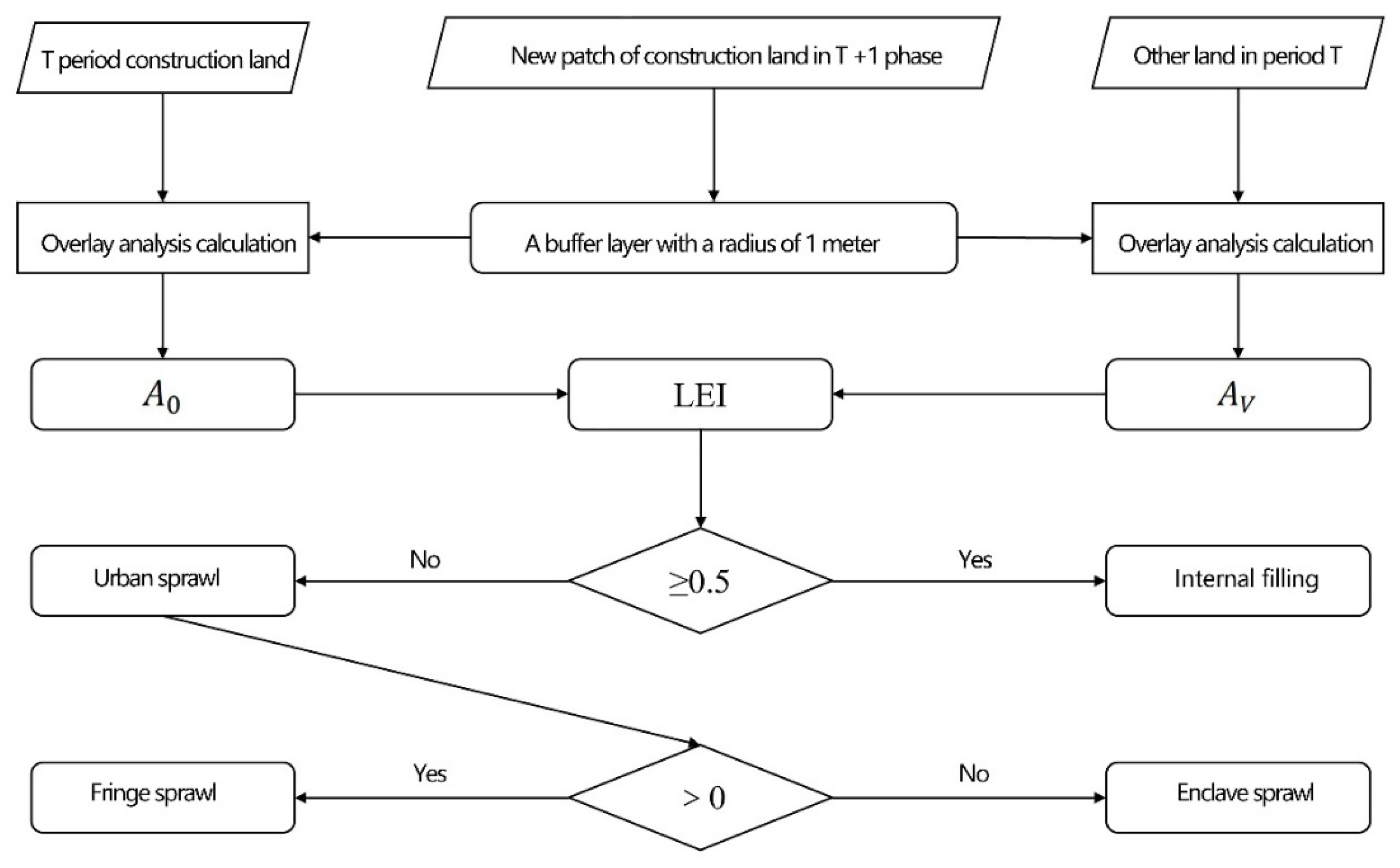
Measurement method combining remote sensing (RS) and GIS. Based on remote sensing image data, nighttime light data, and POI data, a spatial analysis method was used to construct a multi-index measurement system from the dimensions of spatial compactness, population aggregation, construction land efficiency, land growth elasticity, and landscape index to identify and analyze the characteristics of urban sprawl [42,43,44,45,46,47,48], specific methods include fractal geometry [49], sprawl indexes [50,51,52], spatial metrics [53,54], and model method [55,56,57].
Although the image analysis method is intuitive and easy to distinguish, the image quality is easily interfered by a variety of factors, or there may be misjudgment due to the particularity of urban features, which makes the analytical error difficult to be completely eliminated, and also has an obvious adverse impact on the accuracy of longitudinal comparison. In addition, although image analysis can clearly describe the process and patterns of urban expansion and predict the trend of its further expansion, it is difficult to reveal the internal mechanism of urban expansion.
The model method is limited by many technologies such as data acquisition quality, model simplification and index quantification, so it is difficult to effectively improve the authenticity and accuracy of model simulation. Furthermore, the prediction of the future is also easily affected by uncertain factors such as the rapid change of global environment.
In general, the above three measures have advantages and disadvantages (Table 1). The third kind of measurement method has become a major development direction due to abundant data and accessibility.
(3)
Study on the interactive relationship between urban sprawl and housing affordability. Kahn’s case study showed that sprawling metropolitan areas provided greater opportunities for suburban homeownership for black households, i.e., low-income households were likely to own larger homes in sprawling metropolitan areas [58]. Later, he went further and concluded that home ownership rates were 8.5 percentage points higher in the most sprawling cities relative to the most compact cities [59]. However, Kahn’s methodology in measuring a region’s level of sprawl considered only the proportion of jobs located within a ten-mile radius of a city center, or he did not conduct a multi-variate analysis of general housing consumption versus sprawl [2]. Dawkins’s empirical research found that greater sprawl in a metropolitan region was indirectly associated with a shorter time to homeownership among new renters through an improvement in housing affordability, and there was no relationship between sprawl and length to homeownership for low-income renters [60]. Aurand found that the relationship between urban sprawl and the supply of affordable rental units for very low-income households is positive but not statistically significant [61]. Zheng believed that the effective supply of housing determines the speed of urban sprawl [62]. This research indicates that the relationship between urban sprawl and housing affordability is complex and diverse, and needs to be explored further.
In addition, in recent years, several land policy instruments have been used to deal with urban sprawl, for example transferable development right programs. Transfer of development rights (TDR) programs are introduced as an alternative institutional innovation to the traditional regulatory instruments for land development [63]. In terms of collective-owned farmland conservation projects, the core principle of the TDR is the realization of landowners’ development rights. In addition, strong public subsidies, core location of the farmland and strong motivation of the government are three main factors leading to the successful implementation of conservation projects [64]. For conserving privately owned built heritage, the success of TDR programs depends on their transaction costs, efficiency and effectiveness [63]. In order to protect agricultural land and promote sustainable urbanization, the Chinese government has also implemented the ‘Linkage’ Policy (Zengjian Guagou), which requires any increase in new urban land by local governments to be compensated for with an equivalent amount of new arable land [65]. These institutional innovations arising from TDR not only meet the demand for development and conservation but also balance the conflicts between public and private interests.
In conclusion, although the research results on urban sprawl are fruitful, they are also controversial. First, the definition of urban sprawl is ambiguous, which leads to its consequences have been exaggerated or overestimated. Second, due to the various analytical perspectives and measurement indicators of urban sprawl, a relatively unified analysis framework has not been developed, resulting in different evaluation results. Third, some studies select more measurement indicators, and there is a high correlation between multiple indicators. For example, there are high correlations between resident population density and employed population density, and between GDP per unit land area and output value of secondary and tertiary industries per unit land area. Moreover, too many indicators sometimes lead to excessive measurement and misleading measurement. Fourth, landscape metrics are suitable for measuring spatial pattern at micro scale and conducting longitudinal comparative analysis at time scale, but are not suitable for horizontal comparative analysis at spatial scale.
The main purposes of this paper are as follows: (1) on the basis of defining the multiconnotation characteristics of urban sprawl and using RS and GIS methods. First, the urban sprawl of Shanghai is measured by a single index based on the three dimensions of land use continuity, population density and land use benefit. Next, a comprehensive measurement of the three dimensions is carried out. (2) To comprehensively reveal the real picture of urban sprawl in Shanghai from multiple dimensions such as spatial pattern, temporal change, regional heterogeneity, sprawl direction and sprawl distance. (3) The urban sprawl area index, sprawl speed index, and sprawl intensity index are selected to quantitatively measure the temporal change characteristics of urban sprawl, and to clarify the relationship between urban sprawl and effective housing supply in Shanghai metropolitan area.
The knowledge gaps addressed in this study are as follows: (1) Previous studies mainly defined and measured urban sprawl from a single dimension such as discontinuous land use and low population density [22,23], or according to these two core characteristics. In this study, the core feature of land use efficiency was added, and the urban expansion satisfying the three core features of discontinuous land use, low population density and low land use efficiency was defined as urban sprawl. Although there were some previous research results with three dimensions, the third dimension chosen by them is either ecological index [36] or external influence [17]. We believe that ecological indicators or external influences are only external representations of urban sprawl, rather than its intrinsic characteristics. (2) The results of urban sprawl measurement largely depend on the selection of research time scale and spatial scale, and the selection of time scale is particularly important [66]. We shorten the study time interval from the usual 10 years to 5 years, which helps to more accurately identify the discontinuous information of land use patches. Through time series analysis, we found that the effective supply of housing significantly affected the intensity and scale of urban sprawl but not the speed of urban sprawl in Shanghai metropolitan area. (3) Compared with previous studies, we added analytical dimensions such as sprawl direction, sprawl distance and regional heterogeneity, and more finely identified the dynamic evolution characteristics of urban sprawl in Shanghai under different spatio-temporal backgrounds, such as intensity difference, direction difference and circle difference.
The innovations of this paper are as follows: (1) it proposes a multidimensional measurement index system composed of three core characteristics of urban sprawl, which has certain application value. (2) Quantitative identification and presentation of differences in intensity, direction and circle of Shanghai urban sprawl provide data support for understanding the characteristics of Shanghai urban sprawl under different spatio-temporal backgrounds. (3) The long-term relationship between the effective supply of housing and the speed, scale and intensity of urban sprawl in Shanghai is quantitatively revealed, which provides a reference for the formulation of urban sprawl governance strategies.

2. Data and Methods

2.1. Study Area

Shanghai is located in the eastern coastal zone of China, bordered by the East China Sea to the east, Jiangsu Province to the northwest, and Zhejiang Province to the southwest, at 120°51′–122°12′ E longitude and 30°40′–31°51′ N latitude (Figure 1). It is on the alluvial plain of the Yangtze River Delta, with a low average altitude. The city’s climate is subtropical monsoon, with an average temperature of 17.8 °C in 2020, a sunshine duration of 1839.4 h, and annual precipitation of 1660.8 mm. In 2020, Shanghai’s gross domestic product (GDP) reached 3.87 trillion CNY, accounting for 3.84% of China’s GDP. The city has a population of 24,883,600 and a population density of 3925 people per square kilometer.
Since the 1990s, China has witnessed rapid development of industrialization and urbanization with metropolitan areas as the core. As the core city leading the world-class urban agglomeration in the Yangtze River Delta, Shanghai is not only one of the cities with the fastest economic growth in China, but also one of the cities with the largest immigrant population. It is also one of the cities with the most prominent urban spatial expansion in China [21]. Its urban expansion modes are complete and diversified, including internal filling, enclave sprawl and edge sprawl. Over the past 30 years, Shanghai has experienced the evolution from an industrial center to an economic center and then to a rising global city. In the process of transformation and upgrading of industrial structure and urban functions, Shanghai not only did not choose the deindustrialization strategy of metropolitan areas of some developed countries, but also did not appear the large-scale slum phenomenon that exists in the metropolitan areas of Latin America and other developing countries. There is a significant difference between China’s metropolitan sprawl or suburbanization and that of the West in terms of morphology and internal mechanism. China’s urban sprawl is dominated by government-guided suburban development zones, residential suburbanization is later than industrial suburbanization, and the sustained prosperity of urban central areas coexists with low-density expansion of urban periphery areas [66]. Therefore, choosing Shanghai as a case study has strong typicality and representativeness.

2.2. Data Source and Preprocessing

2.2.1. Sources and Interpretation of Remote Sensing Image Data

This article selects the Landsat series produced by NASA’s Landsat images as a data source (http://www.gscloud.cn/, accessed on 1 November 2021) and obtains 14 remote sensing image scenes from seven sessions (1990, 1995, 2000, 2005, 2010, 2015, 2020). Among them, 1990 and 1995 were obtained from Landsat 5; 2000, 2005, and 2010 were from Landsat 7; 2015 and 2020 were from Landsat 8. The corresponding parameters of each satellite are shown in Table 2.
Land use spatial distribution is obtained based on remote sensing image interpretation, which includes the following steps:
(1)
Remote sensing image preprocessing. The preprocessing process includes geometric correction, radiometric calibration, atmospheric correction, image clipping, image mosaicking, image fusion, etc.
(2)
Image classification. When extracting a certain kind of information based on remote sensing image, the corresponding index can be calculated by spectral analysis to achieve the classification effect. According to construction with the characteristics of the corresponding index, using the normalized building index to extract the urban construction land, at the same time, considering the construction land surrounding vegetation affect the classification accuracy of construction land, further using the normalized difference vegetation index of construction land within the scope of the vegetation, to improve the accuracy of classification.
In this paper, urban construction land was extracted by calculating the normalized building index [67], but the extraction accuracy was not high due only to the normalized building index. The vegetation cover area with low density around the urban construction land was also erroneously extracted as construction land [68]. At the same time, vegetation with lower density was eliminated, and the normalized vegetation index was calculated [69,70].
Normalized building index: This index is based on the principle that the DN value of construction land in the mid-infrared band is greater than that in the near-infrared band in remote sensing images. The calculation formula is as follows:
N D B I = ( M I R N I R ) ( M I R + N I R )
where MIR represents the value of the infrared band of the pixel and NIR represents the value of the near-infrared band of the pixel.
Normalized difference vegetation index: Vegetation has different reflection spectral characteristics in different bands. Vegetation is extracted according to the feature that the DN value of vegetation in the near-infrared band is greater than that in the red band in remote sensing images. The calculation formula is as follows:
N D V I = ( N I R R ) ( N I R + R )
where NIR represents the value of the near-infrared band of the pixel, and R represents the value of the red band of the pixel.
In the process of remote sensing image operation, the data of the Landsat 5 TM sensor, Landsat 7 ETM+ sensor, and Landsat 8 OLI sensor are used in this paper. The corresponding bands of the same band number of the three sensors are inconsistent, so the calculation formula needs to be adjusted when calculating the NDBI and NDVI index. The specific calculation formula is shown in Table 3.
Based on the calculation results of NDBI and NDVI, the low-density vegetation cover area was eliminated to obtain urban construction land. However, in this method, the extracted results still contain information on urban unused land. Due to the small number of unutilized urban areas in Shanghai, unutilized urban areas in Shanghai are eliminated by visual recognition. Notably, the spatiotemporal consistency of classification results in different research periods is one of the difficulties in developing land use products [71]. It will impact the analysis of temporal changes in land use, so visual identification is used to test the consistency of temporal changes in the classification result map of construction land.
(3)
Accuracy test. Since the study area of this paper is large, it is not possible to test the accuracy of classification results for the whole city’s construction land. Generally, the method is to verify the accuracy of classification results by collecting sample points. There are three common ways to select sample points: one is training samples similar to supervised classification, the other is sampling samples from selected test sites, and the third is random sampling of sample points. Considering the convenience of operation, this paper chooses the first method to select sample points for accuracy verification.
In this paper, the overall accuracy and Kappa coefficient were calculated based on the classification results of the confusion matrix to evaluate the classification accuracy. The overall accuracy and Kappa coefficient (greater than 0.7) of the image interpretation results in each phase met the accuracy requirements (Table 4), and construction land that met the accuracy requirements was finally obtained (Figure 2).

2.2.2. Spatial Population Data

Commonly used population spatial datasets include the WorldPop, LandScan and China km grid population distribution datasets. Combined with the basic information of the three kinds of population spatial data, after checking the actual population distribution in the study area, the WorldPop dataset with a resolution of 100 m × 100 m was selected as the data source, and a total of 5 periods (2000, 2005, 2010, 2015, 2020) of population spatial data were obtained.

2.2.3. Nighttime Light Data

According to existing studies, nighttime light data are strongly correlated with the regional economy and regional population [72]. Due to the existence of spatial grid data in population dataset and the absence of grid data in regional economy, nighttime light data were used to fit the regional economy, so as to obtain the spatial grid data of regional economy. Nighttime light data products were obtained from the National Environmental Information Center (website address: https://ngdc.noaa.gov/. accessed on 6 October 2021). The basic information provided by the data is shown in Table 5.
Due to the supersaturation phenomenon of urban center in DMSP/OLS data in night light data, almost half of the areas in Shanghai in 2010 data were supersaturated, resulting in the lack of difference in DN value of night light data. In order to eliminate the influence of supersaturated areas, corrected data products were selected as data sources, combined with temporal characteristics. We finally selected the published global night lighting product data as the original data for the research of this paper [73]. For 2000, 2005, 2010, 2015, and 2020, 5 nighttime light data sources (https://dataverse.harvard.edu/dataset.xhtml?PersistentId = https://doi.org/10.7910/DVN/YGIVCD, accessed on 6 October 2021) were obtained.

2.2.4. Other Data

Other data are mainly statistical and spatial data. The statistical data include data on the population, economy, education, medical care, etc., captured mainly from the statistical yearbooks and statistical bulletins of Shanghai and its districts. In terms of spatial data, the vector boundary data of Shanghai are based on the boundary data of the 2017 administrative map. The spatial data of the Shanghai ring line division were obtained according to OpenStreetMap vectorization. The spatial data of traffic stations were also obtained from OpenStreetMap. The distribution data of the Shanghai development zones and water system were obtained from the Shanghai Institute of Geological Survey, while the distribution of water area was obtained from the cloud platform of the National Geographic Survey. The spatial distribution of business districts was obtained from the vectorized data of Shanghai Commercial Network Layout Planning (2014–2020). The ground elevation model (DEM) data were obtained from the geospatial data cloud platform.

2.3. Methods

2.3.1. Sprawl Identification Method Based on Patch Continuity of Newly Constructed Land

According to the time intervals of 1990–1995, 1995–2000, 2000–2005, 2005–2010, 2010–2015, and 2015–2020, through the superposition analysis of images at different periods and the grid calculator, the construction land area and newly added construction land area of the study period were obtained (Figure 3). Based on map spot information of the newly added construction land, according to the latter’s position relationship with the existing construction land, it can be approximately divided into the following four cases (Figure 4): (1) The new map spot is located in the existing built-up area of the city, which is the utilization of the blank land inside the urban built-up area (a red patch in Figure 4). (2) The newly added map spots are located at the edge of the existing construction land in the city but are more connected with the existing construction land, and the public contact surface is large (orange patch in Figure 4). (3) The new map spots are located at the edge of the existing construction land in the city, and they interface with the existing construction land, but the adjacency degree is small (yellow patches in Figure 4). (4) The new map spot is located in the nonurban construction site and has no contact with the existing urban construction land (green patch in Figure 4). Given these cases, we believe that the first and second cases are internal filling expansion, the third case is fringe sprawl, and the fourth case is enclave sprawl. In specific, only the third and fourth cases are urban sprawl.
Urban sprawl identification needs to distinguish urban interior filling and urban sprawl from map spots used for new urban construction land. According to the spatial location of urban interior filling and urban sprawl, there is a few qualitative analyses, but it is necessary to quantitatively identify the urban sprawl in Shanghai in the new map spots, the more commonly used methods are: public edge measure and landscape expansion index (LEI).
The principle of the common edge measurement method is based on the ratio of the common edge length of the new construction land patch and the existing construction land patch to the perimeter of the new construction land patch. The calculation formula is as follows:
S = I C I
where S represents the common edge measurement index, IC represents the length of the common edge between the new construction land and the existing construction land, and I is the edge length of map spots used for new construction land. When S ≥ 0.5, internal filling expansion occurs. When 0 < S < 0.5, it is an urban sprawl. When S = 0, it is an enclave expansion [74,75,76,77].
In the process of identifying urban sprawl, this paper finds that remote sensing images belong to raster data. It is difficult to quantitatively calculate the common edges of new patches and existing patches and the perimeter of new patches in space, and it is difficult to realize automatic calculation. Considering the feasibility of the experiment, the landscape expansion index was selected to identify urban sprawl [78,79,80]. The calculation formula adopted in this paper is as follows:
L E I = A 0 A 0 + A V
where LEI represents the landscape expansion index of the newly added map spots, with a value of [0,1]; A0 denotes the area of overlapping area between the buffer zone of newly added map spots and existing construction land patches; and AV denotes the overlapping area between the newly added map spot buffer area and other land patches in the city. According to the calculation results, LEI was divided into urban internal filling (0.5 ≤ LEI ≤ 1) and urban sprawl (0 ≤ LEI < 0.5). When LEI is equal to 0, it is enclave sprawl, and the remaining areas are fringe sprawl.
Based on the results of the current research [81,82], the paper sets the buffer distance to 1 m, calculates the new patch buffer area and the overlap area of the existing construction land and other land. The landscape expansion index of each new patch was calculated according to Formula (4). Urban sprawl and internal filling are distinguished based on the calculation results (Figure 5).

2.3.2. Spatial Identification Method of Urban Sprawl Based on Population Density

In this paper, areas with higher urban population density than the average urban population density of Shanghai are defined as urban high-density areas, while areas with lower population density are defined as urban sprawl areas. The population distribution data and urban construction land were superimposed to obtain the spatial data of population density in the area covered by urban construction land. In order to eliminate the inconsistent resolution of different datasets, we used weights to redistribute the pixel attribute values of the population density raster data according to the construction land dataset to obtain a dataset consistent with the resolution of the construction land and with both population attribute values. The population density values corresponding to the grid data of construction land in Shanghai in 2000, 2005, 2010, 2015, and 2020 were calculated according to the area sharing method. The calculation results of the mean population density values of the corresponding years are shown in Table 6.

2.3.3. Spatial Identification Method of Urban Sprawl Based on Land Use Benefits

Using nighttime light data as the original data, the gross domestic product (GDP) data were discretized to obtain the spatial grid data of Shanghai’s GDP. The premise of this method is to verify the correlation between GDP data and nighttime light data.
(1)
Temporal correlation. With the nighttime light index as the vertical axis and GDP data as the horizontal axis, a scatter plot was created to show their relationship (Figure 6). The sample data in Figure 6a,b were different. Since Figure 6a only selected the data of 2000, 2005, 2010, 2015 and 2020, the correlation coefficient between nighttime light index and GDP was relatively high, reaching 0.9570, R2 was 0.9158. However, in fact, due to the small amount of sample data, it is easy to overfit. In order to avoid overfitting caused by too little data, annual data from 2000 to 2020 were selected for correlation analysis in Figure 6b, so its correlation coefficient was reduced to 0.8805, R2 was 0.7753. Due to the sharp points of the nighttime light index in 2009 and 2012, if these outliers are removed, the correlation coefficient between the two increases to 0.9350, and the linear fitting degree (R2) increases to 0.8742. The time series analysis showed that the nighttime light index was strongly correlated with GDP. However, temporal changes will ignore the spatial distribution of GDP, so it is necessary to verify the spatial correlation between the nighttime light index and GDP.
(2)
Spatial correlation. The GDP value of each district in Shanghai in 2020 and the total value of the nighttime light data of each district in Shanghai were selected to verify the spatial correlation. The nighttime light index of each district in Shanghai is obtained based on the summary of pixel values of the nighttime light data of administrative boundary statistics of each district in Shanghai (Table 7).
Figure 7 is a scatter plot of GDP data and nighttime light data of 16 districts in Shanghai in 2020. Since the GDP and nighttime light index of the Pudong New Area are much higher than those of other districts, they are far from other points. The correlation coefficient between GDP and nighttime light data was 0.8624 according to linear regression, and the goodness of fit of the equation after linear regression was 0.7431. Both the correlation coefficient and goodness of fit proved that nighttime light data and GDP had a strong correlation.
First, the relational model needs to establish the distribution weight of nighttime light data, that is, the weight of a single raster value in the total raster values. Next, based on the weights of the nighttime light data, the total GDP value is assigned according to the weights to obtain the spatial GDP dataset. The calculation formula is as follows:
G D P i j = G D P * Q i j Q
where GDPij represents the GDP value of a spatial raster; GDP represents the total GDP of the study area; Qij represents the weight value of the grid; and Q denotes the total weight value in the study area.
First, the nighttime light data and construction land data were spatially matched, and the nighttime light attribute value was assigned to the construction land according to the area equalization method. Next, the GDP was allocated according to the weight of the nighttime light data in the construction land to obtain the spatial data of GDP in the construction land. The threshold of land use benefit was determined by the same method as the threshold of population density. The area higher than the city’s average land use benefit was considered the high-benefit area of land use, and the area lower than the city’s average land use benefit was considered the low-benefit area of land use (Table 8).

2.3.4. Spatial Identification Method of Urban Sprawl with Integrated Dimensions

The characteristics of urban sprawl are multidimensional, and single measures based on spatial discontinuity, low population density, or low land use efficiency are all one-sided. The identification of urban sprawl needs to take into account both spatial attributes and connotation attributes. However, there may be spatial inconsistencies between a low population density area and low land use benefit area In specific, the same area may be a low population density area but a high land use benefit area. Therefore, it is necessary to comprehensively identify urban sprawl through a combination of connotation and spatial attributes.
First, the entropy method is used to integrate the population density and land use benefit. Second, the fusion results are spatially matched with the land use continuity data to obtain data with the characteristics of low population density, low land use efficiency and spatial discontinuity, which were identified as urban sprawl areas, and the results are graded. The entropy method is used to calculate the index weight as follows:
(1)
Normalization of indicators. The normalization treatment of indicators needs to distinguish between positive and negative indicators. Positive indicators and negative indicators have different standardization formulas:
Positive   indicators :   x i j = x i j min ( x i j ) max ( x i j ) min ( x i j )
Negative   indicators :   x i j = max ( x i j ) x i j max ( x i j ) min ( x i j )
(2)
Calculate the redundancy of information entropy:
d j = 1 + 1 ln m i = 1 m p i j ( ln p i j )   j = 1 , 2 , , n
where m represents the number of selected indicators and n represents the number of samples. p i j = x i j i = 1 m x i j .
(3)
Index weight calculation:
w j = d j i = 1 m d j
The weights of population density and land use benefit were calculated with the entropy method. The results are shown in Table 9.
According to the calculated weight, the spatial data of the two variables are coupled as follows:
x i j = w 1 * p i j + w 2 * G i j
where x i j represents the comprehensive value corresponding to the jth element in the ith period; p i j represents the population density corresponding to the jth element in the ith period; w 1 is the weight of population density; G i j represents the land use benefit corresponding to the jth element in the ith period; and w 2 is the weight of land use benefit.
Next, the identification results based on the proximity of new patches and the coupling results of the above two are integrated to obtain the combined data of urban sprawl spatial data and population density and land use benefit attributes. Areas with values lower than 0.5 were defined as mild sprawl areas, and areas higher than 0.5 were defined as severe sprawl areas.

2.3.5. Limitations of This Study

The limitations of this paper are as follows: (1) The reduction in urban construction land is not considered in the time series superposition of construction land. In recent years, Shanghai took the lead in putting forward the development concept of negative growth of construction land scale in China and has continuously promoted reductions in inefficient construction land. In the future, the “negative growth” of construction land should be considered when studying the spatiotemporal dynamics of cities. (2) The temporal nature of nighttime light data, inconsistencies in landsat data and differences in data resolution led to certain limitations in the research. For example, landsat has a resolution of 30 m × 30 m, nighttime lights of 1 km × 1 km or 500 m × 500 m, and population density data of 100 m × 100 m. Although the vector grid is unified as 30 m × 30 m in this study, the influence of data resolution cannot be completely eliminated.

3. Results

3.1. Urban Sprawl Pattern Based on Patch Continuity of Newly Added Construction Land

From 1990 to 1995, the urban internal filling area was 88.687 km2, accounting for 27.34% of the new urban construction land area, and the proportion of urban internal filling was relatively high. From 1995 to 2000, internal filling accounted for only 6.23% of the new construction land, and the city was mainly in a state of sprawl. From 2000 to 2015, the proportion of urban internal fill increased greatly, staying between 20% and 30%. The ratio of internal filling even exceeded 30% during 2010–2015. From 2015 to 2020, the proportion of internal infill decreased, while that of urban sprawl increased (Figure 8). In general, urban sprawl has become the dominant mode of urban spatial expansion.
In terms of urban sprawl types, from 1990 to 1995, enclave sprawl accounted for a relatively small proportion, approximately 2.8%, and marginal sprawl accounted for approximately 70%. Between 1995 and 2000, enclave sprawl increased to 15.1%and marginal sprawl to 78%. From 1995 to 2015, the proportion of urban enclave sprawl continued to decline, while marginal sprawl first decreased and then increased. From 2015 to 2020, the proportion of marginal sprawl and enclave sprawl increased, and marginal sprawl was the main sprawl (Figure 9).

3.2. Urban Sprawl Pattern Based on Population Density

In 2000, 2005, 2010, 2015, and 2020, the population and pixel number of high-density population areas and the population and pixel number of low-density population areas in Shanghai were, respectively, counted. The results showed that (Table 10): (1) The population of high-density population areas was larger, but the occupied land area was smaller. The area with low population density has a relatively small population but occupies a large area of land. For example, in 2000, Shanghai’s high-density population areas accounted for only 30% of the construction land, but they contained 75% of the population. (2) From the perspective of time series change, the proportion of the population and land use decreased in high-density areas, while the proportion of the population and land use increased in low-density areas. (3) From the perspective of spatial change, the urban population showed a dual trend of central agglomeration and suburban expansion. Urban high-population density areas were concentrated mainly in the central city and some new city centers, while large areas outside the city were all low-population density areas (Figure 10). The migration of the population from the city center to the suburbs is one reason for the continuous increase in urban sprawl based on the change in population density.

3.3. Urban Sprawl Pattern Based on Land Use Benefits

The GDP and pixel number produced by the high-benefit area and the low-benefit area in the study period were analyzed. The results show the following (Figure 11): (1) The GDP of the high-benefit area accounted for more than 70% of the total GDP, but the land area accounted for only approximately 40%. The low-benefit regions occupied more land area but produced lower GDP. (2) In terms of the time series, the GDP of high-benefit regions and low-benefit regions showed an upwards trend. (3) From the perspective of space (Figure 12), urban high-efficiency areas in 2000 were concentrated in the central urban area, supplemented by some regional centers, such as Jiading, Songjiang, and Qingpu. From 2000 to 2010, the center of high-efficiency areas was concentrated in the central urban area, but several sporadic high-efficiency areas also appeared. Due to the relocation of manufacturing-oriented enterprises from downtown Shanghai to urban fringe areas, industrial agglomeration in the central urban area was weakened, the industries were concentrated in the parks in the urban fringe areas, and there was a low-efficiency zone between the central urban area and the external industrial parks. From 2010 to 2015, high-benefit centers along the urban edge expanded and gradually connected with high-benefit centers in the central city, while the area of low-benefit areas decreased and urban compactness increased. From 2015 to 2020, the area of low-benefit areas increased slightly.

3.4. Multidimensional Measurement Results of Urban Sprawl

Land use with high efficiency, mild sprawl, and severe sprawl in different research periods was statistically analyzed, and the results are shown in Figure 13. The identification results of urban sprawl based on the proximity of new construction land basically reflects the characteristics of inefficient urban land use, and efficient land use accounts for only 1–3%. From 1995 to 2010, the area of urban sprawl increased from 68.44 km2 to 330.12 km2, an increase of approximately 5 times. Severe sprawl was dominant, and the proportion basically showed a rising trend. The proportion of mild urban sprawl and efficient land use generally declined. From 2010 to 2020, the area of urban sprawl continued to decline, and the proportion of mild sprawl increased and exceeded that of severe sprawl.
Overall, from 1995 to 2010, the area of urban sprawl in Shanghai continued to increase, while the proportion of efficient land area continued to decline. Severe sprawl became the dominant mode, and its proportion continued to rise. From 2010 to 2020, urban sprawl gradually slowed, mainly becoming mild sprawl (Figure 14).

3.5. Temporal Volatility of Urban Sprawl

From the perspective of temporal changes, from 1990 to 2020, the total urban sprawl area of Shanghai was 1084.3 km2, with an average annual sprawl area of 36.14 km2. The periods 1990–1995, 2000–2005 and 2005–2010 showed large annual sprawling areas, fast sprawling speeds and high sprawling intensities. Overall, the two periods from 1995 to 2000 and 2015 to 2020 had smaller annual sprawling areas, slower sprawling speeds and weaker sprawling intensities (Table 11). Furthermore, urban sprawl shows temporal volatility and is a phased phenomenon rather than a long-term universal state. Therefore, the extent of urban sprawl should not be overstated. Moreover, in recent years, driven by high-quality urban development, the Master Urban Plan of Shanghai (2017–2035) clearly states that the area of urban construction land will not be increased, and urban sprawl is expected to continue decreasing in the future.

3.6. Regional Heterogeneity of Urban Sprawl

Shanghai urban sprawl also shows significant regional differences (Table 12): (1) The Pudong New Area showed the most serious urban sprawl from 1990 to 1995, accounting for approximately 40% of the total urban sprawl area, and the implementation of the Pudong development strategy was the main reason for the sprawl. The inner suburbs, such as Jiading and Minhang, were the key areas for the outward dispersal of the population from the central urban area, which also showed obvious urban sprawl. (2) From 1995 to 2000, the sprawl area of Songjiang District was 14.5 km2, accounting for 21.13% of the total urban sprawl area. From 2000 to 2005, Songjiang District and Pudong New Area were still the two areas with the most serious sprawl, and the sprawl area of Songjiang District even exceeded that of Pudong New Area. The construction of Songjiang University Town and Songjiang Industrial Parks were the main driving factors. (3) From 2005 to 2010, in addition to the Pudong New Area, Jiading District and Jinshan District also showed prominent sprawl. The development and construction of Jiading New City and Lingang New City and the redevelopment of Jinshan International Chemical City became important driving forces. (4) From 2010 to 2015, except for Pudong New Area and Songjiang District, Qingpu District accelerated its sprawl. (5) From 2015 to 2020, the urban sprawl area further expanded, with Pudong New Area (formerly Nanhui District), Fengxian District, and Songjiang District becoming the main sprawl areas. In general, urban sprawl in Shanghai showed a trend of expansion from the inner suburbs to the outer suburbs.
In addition, urban sprawl has directional differences. Taking People’s Square in Huangpu District of Shanghai as the origin of coordinates, a buffer zone covering Shanghai was established (the radius of the buffer zone was 75 km), and the equal angle of the buffer zone (22.5 degrees) was divided into 16 directions. The results showed that (Figure 15) (1) from 1990 to 1995, urban sprawl in Shanghai was dominated by the NW–NNW, E, and SW and the southwest, east, and northwest directions, with People’s Square as the center, showing equal intensity sprawl and each direction accounting for approximately 10% of the total urban sprawl area. (2) During 1995–2000, the urban sprawl trend of Shanghai was mainly in the southwest direction and the east–southeast direction, accounting for 22.6% and 19.1%, respectively. (3) From 2000 to 2005, the urban sprawl direction was mainly in the southwest direction, and the sprawling area reached 49.576 km2. (4) From 2005 to 2010, the main direction of urban sprawl was the southeast, and the sprawling area reached 51.196 km2, followed by southwest and south. (5) From 2010 to 2020, the urban sprawl in Shanghai was concentrated mainly in the southwest and southeast, but the intensity of sprawl was weaker than that from 2000 to 2010.

3.7. Circle Differentiation of Urban Sprawl

There is also a relationship between urban sprawl and spatial distance. With People’s Square as the center, a multiring concentric buffer covering the whole study area was established. The radius interval of the buffer was set as 5 km, the minimum radius of the concentric circle was 5 km, and the maximum radius of the concentric circle was 80 km. A total of 16 concentric buffer zones were established (Figure 16). The target layer and the concentric circle buffer are superimposed to calculate the total sprawl area of the target layer in each distance range.
The results showed that (Figure 17) within 5 km of People’s Square, the built-up area of the city was completely covered, and urban sprawl did not occur. Within a distance of 5 km to 10 km, the density of urban built-up areas was relatively high, and urban sprawl appeared a little. Urban sprawl in Shanghai was distributed mainly in the range of 10–50 km. From the perspective of the time series, the urban sprawl in Shanghai showed an inverted “V” shape, which first increased and then decreased. In some study periods, there was even a peak period rather than a single peak point. For example, the peak sprawl period from 2000 to 2005 was between 15 km and 35 km. In addition, the peak segment of urban sprawl increased with increasing distance from the center of the circle. From 1990 to 1995, urban sprawl was distributed mainly within 10–20 km of People’s Square, accounting for approximately 44.5%. From 2005 to 2010, the urban sprawl peak was within 25–30 km of People’s Square. From 2010 to 2015, the urban sprawl peak returned to within 20–25 km. The sprawl area decreased significantly from 2015 to 2020. When the distance from People’s Square was more than 50 km, the intensity of urban sprawl gradually weakened and approached 0.
Furthermore, from the distribution of ring lines (inner ring, middle ring, outer ring, and suburban ring) (Figure 18), the following can be observed: (1) The areas between the suburban ring and outer ring and outside the suburban ring have always been the key areas of urban sprawl in Shanghai. From 1990 to 1995, these two areas accounted for 71.3% of urban sprawl. Since then, the proportion of sprawl in these two areas has continued to rise, reaching as high as 96.3% from 2005 to 2010. Subsequently, the proportion of sprawl decreased but remained at approximately 90% (Figure 19). (2) The area inside the outer ring was the central city, and the sprawl proportion showed a trend of first decreasing and then increasing. The sprawl area between the middle ring and the outer ring has increased in recent years.

4. Discussion

4.1. Indicators and Methods of Urban Sprawl Measurement

The main purpose of measuring urban sprawl is to use quantitative indicators or mathematical methods to reveal the process, pattern and internal mechanism of urban sprawl, so as to provide scientific basis for understanding and controlling urban sprawl. Some scholars measure urban sprawl by the ratio between urban construction land expansion rate and urban population growth rate. When the former is greater than the latter, there is a phenomenon of urban sprawl [83]. However, since the interactive evolution relationship between land urbanization and population urbanization is not fixed in the long term, it is not necessarily a sign of urban sprawl that the speed of land urbanization is faster than that of population urbanization in a certain period. Some scholars believed that urban sprawl must mean excessive suburbanization [84]. However, so far, the measurement method of suburbanization itself is not mature, let alone the measurement of excessive suburbanization.
The advantages of single index method are intuitive, easy to obtain data and simple to calculate. The main problems of this method are as follows: (1) The discrimination basis is single, and it cannot fully reflect the combination change characteristics of urban space elements (population, land, industry, economy, form, etc.). (2) The density method measures the proportional, uniform and continuous changes between the material and the corresponding area [20], so it is difficult to measure the non-continuous leapfrog expansion. (3) It is difficult to reveal the stage differences of urban spatial evolution and the state transformation characteristics of “sprawl” and “non-sprawl”, which are measured by the fractal dimension only relative values rather than absolute values.
In general, the multi-dimensional index method is superior to the single index method. Urban sprawl is characterized by complexity, dynamic and regional differences. In order to better reveal the process, patterns and internal mechanism of urban sprawl, it is worth trying to carry out interdisciplinary comprehensive research with the help of GIS and RS technology.
It is also worth noting that urban sprawl is related to the modes of urban expansion. In the United States, urban sprawl can be regarded as the leapfrog ribbon-like expansion of low density, single land use and commercial and residential separation along traffic arteries. However, in the construction of intensive cities in Japan, the high-density and mixed land use formed by the development and construction along the transportation axis and the compact layout combining commercial and residential areas based on the good public transportation system should not be regarded as urban sprawl [20].
In addition, in the measurement of urban sprawl, the choice of time scale is also very important [66]. First, the total duration should not be too short and should be able to show the characteristics of different stages of economic development. The period from 1990 to 2020 is a period of rapid development of industrialization and urbanization and prominent urban sprawl in Shanghai. Second, the time interval should be moderate, which can more accurately reflect the change information of land use pattern, population distribution and land use efficiency. We think a 5-year interval is better than a 10-year interval.
The changes of land, population and their allocative efficiency are the core characteristics to identify urban sprawl. In this study, the measurement index system is constructed according to these three core characteristics. Compared with previous studies [17,21,40,42,66], the indices of the measure are both dominant and concise, and the results of empirical measurement are very consistent with the reality of urban sprawl in Shanghai, so the measurement method has good reference value.

4.2. Does the Effective Housing Supply Determine the Speed of Urban Sprawl?

The effective supply of housing is an important means to stabilize housing prices and promote the healthy development of the real estate market. It is affected by the comprehensive effects of land supply structure, the development cycle of developers and national policy regulation [85,86]. The housing supply rate is an important indicator for evaluating housing capacity [87]. The effective housing supply not only depends on the design of real estate developers and the proportion of housing sold by the market, but more importantly, it can be delivered to meet housing demand in that year. In China, the ratio of the floor area under construction to the floor area completed is usually used as an indicator of the effective housing supply. Table 13 shows the ratio of residential construction area to completed residential area in Shanghai from 1990 to 2020.
We believe that reside, employment, and living facilities are interrelated, and their spatial separation is the result of urban sprawl. However, housing is only one of the elements. What impact does the effective housing supply have on urban sprawl in the spatial and temporal coordination of housing, employment, and services? To answer this question, we analyze the correlation between the ratio of residential construction area to completed residential area and the urban sprawl index. The calculation results showed that (Table 14) during the study period (1990–2020), there was a significant negative correlation between the urban sprawl area index and the ratio of residential construction area to completed residential area (r = −0.705, p = 0.022 < 0.05) and a highly significant negative correlation between urban sprawl intensity and the ratio of residential construction area to completed residential area (r = −0.706, p = 0.008 < 0.01). In conclusion, the effective housing supply significantly affects the intensity and scale of urban sprawl in Shanghai but not the speed of urban sprawl.
The significant negative correlation between the ratio of residential construction area and completed residential area and urban sprawl intensity reflects, to some extent, the government’s tendency to increase residential land supply when the completion rate is insufficient and the effective housing supply is difficult to guarantee. However, the construction area of residential buildings has shown an upwards trend in recent years, while the corresponding construction area of residential buildings has remained relatively stable. To some extent, these trends show that even if the government increases the land supply, developers may actively use land, increase land storage, delay construction progress, and engage in other behaviors to increase the ineffective housing supply under economic uncertainty and government policy tightening. Such behavior may further lead to “supply interruption”, thus affecting or even disrupting the effective order of the real estate market and even the financial market.
Ensuring the effective supply of housing is particularly important for meeting residents’ housing needs and stabilizing the real estate market. Blindly releasing land while ignoring the transformation of effective housing supply may fail to meet effective policy expectations. Relevant studies also show that, for the housing supply policy of the elderly population, the housing supply that ensures the feasibility of reconstruction is more effective than housing land development [89,90]. Shanghai has become an ageing society. In addition to paying attention to the structure of residential land transfer, we should also consider the completed area of residential buildings and the ratio of residential construction area and completed residential area to ensure the effective supply of residential buildings.

4.3. On the Generalisability of the Findings of This Study

Fringe sprawl has been the dominant mode of urban sprawl in Shanghai for the past 30 years, accounting for more than 70% of the total urban sprawl. Therefore, we should focus on the governance of fringe sprawl, promote the reduction in construction land, improve the level and efficiency of land use through the transformation and upgrading of industrial structure and the optimization of population distribution, and promote the compact and high-quality urban development. At present, Shanghai is implementing the development and construction of “five new cities”. The boundaries of new city development should be strictly defined and refined management and control should be strengthened.
We found that the main directions of urban sprawl in Shanghai were southeast and southwest, and Pudong New Area and Songjiang District were the key sprawl areas. This indicates that the center of gravity of Shanghai’s urban development has shifted to the south, and the single-center city pattern has evolved into a multi-center city pattern. In fact, the southern region is also the area with the greatest potential for development in Shanghai. At the same time, the southern part of Shanghai is rich in ecological resources and agricultural resources. Therefore, we should plan the future development of southern Shanghai with a broader mind and a higher position, and create a new pattern of high-quality development featuring innovation, green, low-carbon, ecologically livable, regional cooperation and social affinity.
We also found that the effective supply of housing significantly affected the intensity and scale of urban sprawl but not the speed of urban sprawl in Shanghai metropolitan area from 1990 to 2020. In fact, in the process of urban expansion, the impact of expansion scale and intensity is far greater than the expansion speed. Since the effect of the former is direct, while the effect of the latter is indirect. This also suggests that we should focus on controlling the scale and intensity of urban sprawl in the governance of urban sprawl. In addition, the scale and intensity of residential suburbanization in metropolitan areas must be properly controlled. Along with manufacturing suburbanization, residential suburbanization has become the main drivers of urban sprawl in the metropolitan areas of China over the past 30 years.

5. Conclusions

We believe that in the process of urban space expansion, new construction land can be defined as urban sprawl only when it exhibits the three characteristics of discontinuity in land use space, low population density and low land use efficiency.
Urban sprawl occurred in Shanghai from 1990 to 2020. Land use patch continuity indicated that marginal sprawl was the main mode of urban sprawl. Based on population density, urban sprawl showed a continuous rising trend. Based on the land use benefit, it showed an “N”-type change trend of first increasing, then decreasing and again increasing. From the comprehensive perspective of multiple dimensions, urban sprawl changed from severe to mild in 2010. The comprehensive measurement results based on the multiconnotation characteristics of urban sprawl can erase the limitation of a single measurement of urban sprawl.
From a time series perspective, the urban sprawl of Shanghai from 1990 to 2020 showed a trend of first decreasing, then increasing and again decreasing, consistent with the change trend of new construction land in Shanghai. In addition, the sprawl area of Shanghai is inversely proportional to the land use efficiency of the sprawl area. In specific, the larger the sprawl area is, the lower the land use efficiency of the sprawl area is. Through time series analysis, we found that the effective supply of housing significantly affected the intensity and scale of urban sprawl but not the speed of urban sprawl in Shanghai.
Through the analysis of multiple spatial scales, we found that the direction of sprawl was mainly southeast and southwest, the peak of sprawl mainly occurred at 20–30 km and was located in the area between the outer ring and the suburban ring, and the development of new towns and new industrial parks was main drivers in Shanghai.
Based on multi-source geospatial data, this paper puts forward the technical ideas and methods for measuring urban sprawl in multiple dimensions, and takes Shanghai as an example for empirical application. How applicable and adequate are these methods for other cities? We will select more cities for further comparative study in the future.

Author Contributions

Y.S.: manuscript writing, technical guidance and fund acquisition. L.Z.: conceptual design and visualization. X.G.: methodology, data processing and validation. J.L.: formal analysis and investigation. All authors have read and agreed to the published version of the manuscript.

Funding

This research was supported by Shanghai Planning and Land Resource Administration Bureau. The one of key projects for Shanghai General Land Use Planning Revision (2015(D)-002(F)-11).

Institutional Review Board Statement

Not applicable.

Informed Consent Statement

Not applicable.

Data Availability Statement

Data and materials are available from the authors upon request.

Acknowledgments

The authors thank the anonymous reviewers for their valuable comments and suggestions on this article.

Conflicts of Interest

The authors declare no conflict of interest.

References

  1. Whyte, W.H. Urban Sprawl: The Exploding Metropolis; Doubleday: New York, NY, USA, 1958. [Google Scholar]
  2. Ewing, R.; Hamidi, S. Compactness versus sprawl: A review of recent evidence from the United States. J. Plan. Lit. 2015, 30, 413–432. [Google Scholar] [CrossRef]
  3. Pendall, R. Do land-use controls cause sprawl? Environ. Plan. B Plan. Des. 1999, 26, 555–571. [Google Scholar] [CrossRef] [Green Version]
  4. Kim, K. Development of an urban sprawl measure based density-spatial structure. J. Korean Cartogr. Assoc. 2017, 17, 87–101. [Google Scholar]
  5. Ewing, R.; Pendall, R.; Chen, D. Measuring Sprawl and Its Impact; Smart Growth America: Washington, DC, USA, 2002. [Google Scholar]
  6. Miller, M.D. The impacts of Atlanta’s urban sprawl on forest cover and fragmentation. Appl. Geogr. 2012, 34, 171–179. [Google Scholar] [CrossRef]
  7. Bereitschdft, B.; Debbage, K. Urban form, air pollution, and CO2 emissions in large U.S. metropolitan areas. Prof. Geogr. 2013, 65, 612–635. [Google Scholar] [CrossRef]
  8. Mohamed, A.; Worku, H. Quantification of the land use/land cover dynamics and the degree of urban growth goodness for sustainable urban land use planning in Addis Ababa and the surrounding Oromia special zone. J. Urban Manag. 2019, 8, 145–158. [Google Scholar] [CrossRef]
  9. Nonomura, A.; Kitahara, M.; Masuda, T. Impact of land use and land cover changes on the ambient temperature in a middle scale city, Takamatsu, in Southwest Japan. J. Environ. Manag. 2009, 90, 3297–3304. [Google Scholar] [CrossRef]
  10. Andong, R.F.; Sajor, E. Urban sprawl, public transport, and increasing CO2 emissions: The case of Metro Manila, Philippines. Environ. Dev. Sustain. 2017, 19, 99–123. [Google Scholar] [CrossRef]
  11. Kashem, S.B.; Irawan, A.; Wilson, B. Evaluating the dynamic impacts of urban form on transportation and environmental outcomes in US cities. Int. J. Environ. Sci. Technol. 2014, 11, 2233–2244. [Google Scholar] [CrossRef] [Green Version]
  12. Ewing, R.; Meakins, G.; Hamidi, S.; Nelson, A.C. Relationship between urban sprawl and physical activity, obesity, and morbidity—Update and refinement. Health Place 2014, 26, 118–126. [Google Scholar] [CrossRef] [Green Version]
  13. Hamidi, S.; Ewing, R. A longitudinal study of changes in urban sprawl between 2000 and 2010 in the United States. Landsc. Urban Plan. 2014, 128, 72–82. [Google Scholar] [CrossRef]
  14. Aljoufie, M.; Zuidgeest, M.; Brussel, M.; Van Maarseveen, M. Spatial-temporal analysis of urban growth and transportation in Jeddah City, Saudi Arabia. Cities 2013, 31, 57–68. [Google Scholar] [CrossRef]
  15. Dutton, J.A. New American Urbanism: Reforming the Suburban Metropolis; Skira Architecture Library: Milano, Italy, 2000. [Google Scholar]
  16. Burchell, R.W.; Downs, A.; McCann, B.; Mukherji, S. Sprawl Costs: Economic Impacts of Unchecked Development; Island Press: Washington, DC, USA, 2005. [Google Scholar]
  17. Jiang, F.; Liu, S.; Yuan, H. Measuring urban sprawl in Beijing with geo-spatial indices. J. Geogr. Sci. 2007, 17, 469–478. [Google Scholar] [CrossRef]
  18. Choi, M.J.; Kim, D.H. Comparative analyses of urban sprawl among Seoul, Jakarta, Manila, and Bangkok metropolitan regions. J. Korea Plan. Assoc. 2019, 54, 30–39. [Google Scholar] [CrossRef]
  19. Osman, T.; Arima, T.; Divigalpitiya, P. Measuring urban sprawl patterns in greater Cairo metropolitan region. J. Indian Soc. Remote Sens. 2016, 44, 287–295. [Google Scholar] [CrossRef]
  20. Shi, S.; Shi, Y. Multi-dimensional reflections of urban sprawl. Hum. Geogr. 2017, 32, 54–59. (In Chinese) [Google Scholar]
  21. Wang, J.; Xie, Y.; Ma, H.; Cai, S. A study on the multi-index measure of urban sprawl in China: Based on the background of rapid urbanization. City Plan. Rev. 2019, 43, 9–19. (In Chinese) [Google Scholar]
  22. Fulton, W.; Pendall, R.; Nguyen, M.; Harrison, A. Who Sprawls Most? How Growth Patterns Differ Across the US; Brookings Institution: Washington, DC, USA, 2001. [Google Scholar]
  23. Lopez, R.; Hynes, H.P. Sprawl in the 1990s: Measurement, distribution and trends. Urban Aff. Rev. 2003, 38, 325–355. [Google Scholar] [CrossRef]
  24. Sultana, S.; Weber, J. The nature of urban growth and the commuting transition: Endless sprawl or a growth wave? Urban Stud. 2014, 51, 544–576. [Google Scholar] [CrossRef] [Green Version]
  25. Fallah, B.N.; Partridge, M.D.; Olfert, M.R. Urban sprawl and productivity: Evidence from US metropolitan areas. Pap. Reg. Sci. 2011, 90, 451–472. [Google Scholar] [CrossRef]
  26. Liu, L.; Peng, Z.; Wu, H.; Jiao, H.; Yu, Y.; Zhao, J. Fast identification of urban sprawl based on K-Means clustering with population density and local spatial entropy. Sustainability 2018, 10, 2683. [Google Scholar] [CrossRef] [Green Version]
  27. Seevarethnam, M.; Rusli, N.; Ling, G.H.T.; Said, I. A geo-spatial analysis for characterising urban sprawl patterns in the Batticaloa Municipal Council, Sri Lanka. Land 2021, 10, 636. [Google Scholar] [CrossRef]
  28. Triantakonstantis, D.; Stathakis, D. Examining urban sprawl in Europe using spatial metrics. Geocarto Int. 2015, 30, 1092–1112. [Google Scholar] [CrossRef]
  29. Sohb, J.; Choi, S.; Lewis, R.; Knaap, G. Characterising urban sprawl on a local scale with accessibility measures. Geogr. J. 2012, 178, 230–241. [Google Scholar]
  30. Fuladlu, K. Urban sprawl measurement with use of VMT pattern: A longitudinal method in case of Famagusta. Int. J. Adv. Appl. Sci. 2020, 7, 12–19. [Google Scholar] [CrossRef]
  31. Gao, B.; Huang, Q.; He, C.; Sun, Z.; Zhang, D. How does sprawl differ across cities in China? A multi-scale investigation using nighttime light and census data. Landsc. Urban Plan. 2016, 148, 89–98. [Google Scholar] [CrossRef]
  32. Salvati, L.; Munafo, M.; Morelli, V.G.; Sabbi, A. Low-density settlements and land use changes in a Mediterranean urban region. Landsc. Urban Plan. 2012, 105, 43–52. [Google Scholar] [CrossRef]
  33. Zhang, X.; Lu, L.; Ren, Y.; Xu, Y.; Zhang, H. Spatial and temporal patterns and influencing factors of urban sprawl in China. Econ. Geogr. 2021, 41, 77–85. (In Chinese) [Google Scholar]
  34. Galster, G.; Hanson, R.; Ratcliffe, M.R.; Wolman, H.; Coleman, S.; Freihage, J. Wrestling sprawl to the ground: Defining and measuring an elusive concept. Hous. Policy Debate 2001, 12, 681–717. [Google Scholar] [CrossRef]
  35. Hasse, J.E.; Lathrop, R.G. Land resource impact indicators of urban sprawl. Appl. Geogr. 2003, 23, 159–175. [Google Scholar] [CrossRef]
  36. Frenkel, A.; Shkenazi, M. Measuring urban sprawl: How can we deal with it. Environ. Plan. B Plan. Des. 2008, 35, 56–79. [Google Scholar] [CrossRef] [Green Version]
  37. Mustafa, A.; Teller, J. Self-reinforcing processes governing urban sprawl in Belgium: Evidence over six decades. Sustainability 2020, 12, 4097. [Google Scholar] [CrossRef]
  38. Garrido-Cumbrera, M.; Galvez Ruiz, D.; Brace, O.; Lara, E.L. Exploring the association between urban sprawl and mental health. J. Transp. Health 2018, 10, 381–390. [Google Scholar] [CrossRef]
  39. Hortas-Rico, M.; Sole-Olle, A. Does urban sprawl increase the costs of providing local public services? Evidence from Spanish municipalities. Urban Stud. 2010, 47, 1513–1540. [Google Scholar] [CrossRef] [Green Version]
  40. Tian, L.; Li, Y.; Yan, Y.; Wang, B. Measuring urban sprawl and exploring the role planning plays: A shanghai case study. Land Use Policy 2017, 67, 426–435. [Google Scholar] [CrossRef]
  41. Xu, X.; Chen, Z.; Ding, X. Measurement and control strategy of regional central city sprawl trend: A case study of Linyi City in Shandong Province. China Land Sci. 2019, 33, 85–92. (In Chinese) [Google Scholar]
  42. Yue, W.; Wu, T.; Liu, X.; Zhang, L.; Wu, C.; Ye, Y.; Zheng, G. Development of a sprawl index for large cities in China. Acta Geogr. Sin. 2020, 75, 2730–2743. (In Chinese) [Google Scholar]
  43. Ehrlich, M.V.; Hilber, C.; Schni, O. Institutional settings and urban sprawl: Evidence from Europe. J. Hous. Econ. 2017, 42, 4–18. [Google Scholar] [CrossRef]
  44. Manesha, E.P.P.; Jayasinghe, A.; Kalpana, H.N. Measuring urban sprawl of small and medium towns using GIS and remote sensing techniques: A case study of Sri Lanka. Egypt. J. Remote Sens. Space Sci. 2021, 24, 1051–1060. [Google Scholar] [CrossRef]
  45. Alsharif, A.A.A.; Pradhan, B. Urban sprawl analysis of Tripoli metropolitan city (Libya) using remote sensing data and multivariate logistic regression model. J. Indian Soc. Remote Sens. 2014, 42, 149–163. [Google Scholar] [CrossRef]
  46. Zhang, X.; Pan, J. Spatial and temporal dynamics identification and driving factors of urban sprawl in China. Hum. Geogr. 2021, 36, 114–125. (In Chinese) [Google Scholar]
  47. Maithani, S. A quantitative spatial model of urban sprawl and its application to Dehradun urban agglomeration, India. J. Indian Soc. Remote Sens. 2020, 48, 1583–1592. [Google Scholar] [CrossRef]
  48. Zhang, J.; Chen, X.; Xiu, C. Urban sprawl measurement based on POI data: A case study of Shenyang City. China Land Sci. 2019, 33, 93–102. (In Chinese) [Google Scholar]
  49. Terzi, F.; Kaya, H.S. Dynamic spatial analysis of urban sprawl through fractal geometry: The case of Istanbul. Environ. Plan. B Plan. Des. 2011, 38, 175–190. [Google Scholar] [CrossRef]
  50. Martellozzo, F.; Clarke, K.C. Measuring urban sprawl, coalescence, and dispersal: A case study of Pordenone, Italy. Environ. Plan. B Plan. Des. 2011, 38, 1085–1104. [Google Scholar] [CrossRef]
  51. Bhatta, B.; Saraswati, S.; Bandyopadhyay, D. Quantifying the degree-of-freedom, degree-of sprawl, and degree-of-goodness of urban growth from remote sensing data. Appl. Geogr. 2010, 30, 96–111. [Google Scholar] [CrossRef]
  52. Schneider, A.; Chang, C.; Paulsen, K. The changing spatial form of cities in Western China. Landsc. Urban Plan. 2015, 135, 40–61. [Google Scholar] [CrossRef]
  53. Tong, L.; Hu, S.; Frazier, A.E. Hierarchically measuring urban expansion in fast urbanizing regions using multi-dimensional metrics: A case of Wuhan metropolis, China. Habitat Int. 2019, 94, 102070. [Google Scholar] [CrossRef]
  54. Taubenböck, H.; Wiesner, M.; Felbier, A.; Marconcini, M.; Esch, T.; Dech, S. New dimensions of urban landscapes: The spatio-temporal evolution from a polynuclei area to a mega-region based on remote sensing data. Appl. Geogr. 2014, 47, 137–153. [Google Scholar] [CrossRef]
  55. Sudhira, H.S.; Ramachandra, T.V.; Jagadish, K.S. Urban sprawl: Metrics, dynamics and modelling using GIS. Int. J. Appl. Earth Obs. Geoinf. 2004, 5, 29–39. [Google Scholar] [CrossRef]
  56. Wilson, E.H.; Hurd, J.D.; Civco, D.L.; Prisloe, M.P.; Arnold, C. Development of a geospatial model to quantify, describe and map urban growth. Remote Sens. Environ. 2003, 86, 275–285. [Google Scholar] [CrossRef]
  57. Deep, S.; Saklani, A. Urban sprawl modeling using cellular automata. Egypt. J. Remote Sens. Space Sci. 2014, 17, 179–187. [Google Scholar] [CrossRef] [Green Version]
  58. Kahn, M.E. Does sprawl reduce the Black/White housing consumption gap? Hous. Policy Debate 2001, 12, 77–86. [Google Scholar] [CrossRef]
  59. Kahn, M.E. The Quality of Life in Sprawled versus Compact Cities. In Transport, Urban Form and Economic Growth; OECD Publishing: Paris, France, 2007. [Google Scholar]
  60. Dawkins, C.J. Urban sprawl and the transition to first-time homeownership. Cityscape J. Policy Dev. Res. 2009, 11, 83–100. [Google Scholar]
  61. Aurand, A. Does sprawl induce affordable housing? Growth Chang. 2013, 44, 631–649. [Google Scholar] [CrossRef]
  62. Zheng, R. The Rise and Fall of Cities: Based on Economic, Social and Institutional Logics; Guangxi Normal University Press: Guilin, China, 2021. (In Chinese) [Google Scholar]
  63. Hou, J.; Gu, D.; Shahab, S.; Chan, E.H. Implementation analysis of transfer of development rights for conserving privately owned built heritage in Hong Kong: A transactions costs perspective. Growth Chang. 2020, 51, 530–550. [Google Scholar] [CrossRef]
  64. Liang, X.; Yuan, Q.; Tan, X.; Chen, S. The conservation of collective-owned farmland via the transfer of development rights (TDR) in China--The case of ecological fruit park in Guangzhou. J. Rural. Stud. 2020, 78, 99–410. [Google Scholar] [CrossRef]
  65. Shi, C.; Tang, B.-S. Institutional change and diversity in the transfer of land development rights in China: The case of Chengdu. Urban Stud. 2020, 57, 473–489. [Google Scholar] [CrossRef]
  66. Zhang, L.; Yue, W.; Fan, B. Measuring urban sprawl in large Chinese cities: A case study of Hangzhou. Sci. Geogr. Sin. 2014, 34, 394–400. (In Chinese) [Google Scholar]
  67. Zha, Y.; Ni, S.; Yang, S. An effective approach to automatically extract urban land-use from TM imagery. J. Remote Sens. 2003, 7, 37–40. (In Chinese) [Google Scholar]
  68. Ma, Y.; Zhao, M.; Zhou, P.; Wang, J. Comparison of impervious surface extraction index based on two kinds of satellite sensors. Spacecr. Recovery Remote Sens. 2021, 42, 139–151. (In Chinese) [Google Scholar]
  69. Ziyu, S.; Junbang, W. The 30m-NDVI-based alpine grassland changes and climate impacts in the Three-River headwaters region on the Qinghai-Tibet Plateau from 1990 to 2018. J. Resour. Ecol. 2022, 13, 186–195. [Google Scholar] [CrossRef]
  70. Deering, D.W. Rangeland Reflectance Characteristics Measured by Aircraft and Spacecraft Sensors; Texas A&M University: Texas, TX, USA, 1978. [Google Scholar]
  71. Xu, X.; Li, B.; Liu, X.; Li, X.; Shi, Q. Global annual land cover mapping with 30 m resolution from 2000 to 2015. J. Remote Sens. 2021, 25, 1896–1916. (In Chinese) [Google Scholar]
  72. Zhang, Y.; Cao, Z.; Wei, W.; Hu, J. A study on space-time coupling relationship between nightlight data and the indicators of social and economic development in the Yellow River basin. Bull. Surv. Mapp. 2021, 67, 20–27. (In Chinese) [Google Scholar]
  73. Chen, Z.; Yu, B.; Yang, C.; Zhou, Y.; Yao, S.; Qian, X.; Wang, C.; Wu, B.; Wu, J. An extended time series (2000–2018) of global NPP-VIIRS-like nighttime light data from a cross-sensor calibration. Earth Syst. Sci. Data 2021, 13, 889–906. [Google Scholar] [CrossRef]
  74. Sun, C.; Wu, Z.; Lv, Z.; Yao, N.; Wei, J.-B. Quantifying different types of urban growth and the change dynamic in Guangzhou using multi-temporal remote sensing data. Int. J. Appl. Earth Obs. Geoinf. 2013, 21, 409–417. [Google Scholar] [CrossRef]
  75. Jiao, L.; Mao, L.; Liu, Y. Multi-order landscape expansion index: Characterizing urban expansion dynamics. Landsc. Urban Plan. 2015, 137, 30–39. [Google Scholar] [CrossRef]
  76. Sarzynski, A.; Galster, G.; Stack, L. Typologies of sprawl: Investigating United States metropolitan land use patterns. Urban Geogr. 2014, 35, 48–70. [Google Scholar] [CrossRef]
  77. Yu, Y.; Hu, S.; Tong, Y.; Ke, Y. Modeling of urban expansion mode based on common edge measure. Geogr. Geogr. Inf. Sci. 2017, 33, 78–81. (In Chinese) [Google Scholar]
  78. Zhou, X.; Fu, Y.; Lang, W.; Li, M. Spatio-temporal evolution of built-up areas and its influencing factors from the perspective of compact cities: A case study of Shanghai. Shanghai Urban Plan. Rev. 2021, 25, 91–97. (In Chinese) [Google Scholar]
  79. Liu, X.; Li, X.; Chen, Y.; Qin, Y.; Li, S.; Chen, M. Landscape expansion index and its application in urban expansion analysis. Acta Geogr. Sin. 2009, 64, 1430–1438. (In Chinese) [Google Scholar]
  80. Wu, J.; Luo, K.; Zhao, Y. Urban landscape pattern evolution and its driving factors in Shenzhen City in recent 20 years. Geogr. Res. 2020, 39, 1725–1738. (In Chinese) [Google Scholar]
  81. Ouyang, X.; Zhu, X. Spatial-temporal dynamics of urban land expansion in urban agglomerations in China. Acta Geogr. Sin. 2020, 75, 571–588. (In Chinese) [Google Scholar]
  82. Liu, X.; Xia, L.; Chen, Y.; Tan, Z.; Li, S.; Ai, B. A new landscape index for quantifying urban expansion using multi-temporal remotely sensed data. Landsc. Ecol. 2010, 25, 671–682. [Google Scholar] [CrossRef]
  83. Liu, J.; Jiao, L.; Dong, T.; Xu, G.; Zhang, B.; Yang, L. A new measure of urban landscape expansion process: Multi-order adjacency index. Sci. Geogr. Sin. 2018, 38, 1741–1749. (In Chinese) [Google Scholar]
  84. Ewing, R. Is Los Angeles-style sprawl desirable? J. Am. Plan. Assoc. 1997, 63, 107–126. [Google Scholar] [CrossRef]
  85. Mills, E.S. Urban sprawl causes, consequences and policy responses. Reg. Sci. Urban Econ. 2003, 33, 251–252. [Google Scholar] [CrossRef]
  86. Mayo, S.; Sheppard, S. Housing supply under rapid economic growth and varying regulatory stringency: An international comparison. J. Hous. Econ. 1996, 5, 274–289. [Google Scholar] [CrossRef]
  87. Kong, J.H. A Study on effective demand and supply to determine housing price: Panel regression model analysis for 7 metropolitan cities. J. Korea Real Estate Anal. Assoc. 2022, 28, 7–20. [Google Scholar]
  88. Shanghai Municipal Statistics Bureau. 2021 Statistical Yearbook of Shanghai; China Statistical Publishing House: Beijing, China, 2021. (In Chinese) [Google Scholar]
  89. Byeon, C.-H. A study on the estimation of housing supply ratio using housing capacity standard in Seoul. Hous. Stud. 2004, 12, 29–54. [Google Scholar]
  90. Park, S.; Han, T.-H. The effect of housing supply policy in the time of aging population on housing deterioration. Korean Syst. Dyn. Rev. 2019, 20, 5–27. [Google Scholar] [CrossRef]
Figure 1. Study area.
Sustainability 15 01020 g001
Figure 2. Construction land distribution in Shanghai (1990–2020).
Sustainability 15 01020 g002
Figure 3. The expansion of urban construction land in Shanghai (1990–2020).
Sustainability 15 01020 g003
Figure 4. The spatial distribution of newly-added construction land.
Sustainability 15 01020 g004
Figure 5. Urban sprawl identification flow chart based on newly-added construction land patches.
Sustainability 15 01020 g005
Figure 6. Scatter plot of nighttime light index and GDP. (a) The correlation coefficient between nighttime light index and GDP in 2000, 2005, 2010, 2015 and 2020. (b) The correlation coefficient between nighttime light index and GDP from 2000 to 2020.
Sustainability 15 01020 g006
Figure 7. Scatter plot of GDP and nighttime light index of each district in Shanghai in 2020.
Sustainability 15 01020 g007
Figure 8. Identification map of urban sprawl in Shanghai from 1995 to 2020.
Sustainability 15 01020 g008
Figure 9. The change in the proportion of urban sprawl and urban internal filling.
Sustainability 15 01020 g009
Figure 10. The identification results of urban sprawl in Shanghai based on population density from 2000 to 2020.
Sustainability 15 01020 g010
Figure 11. GDP and pixel count statistics of high-benefit and low-benefit regions.
Sustainability 15 01020 g011
Figure 12. Identification results of urban sprawl based on land use benefits from 2000 to 2020.
Sustainability 15 01020 g012
Figure 13. Spatial distribution of urban sprawl in Shanghai during the period 1995–2020.
Sustainability 15 01020 g013
Figure 14. Urban sprawl grading results in Shanghai during the period 1995–2020.
Sustainability 15 01020 g014
Figure 15. A radar map of urban sprawl in Shanghai from 1990 to 2020.
Sustainability 15 01020 g015
Figure 16. A schematic diagram of a buffer zone analysis in Shanghai.
Sustainability 15 01020 g016
Figure 17. The relationship between urban sprawl area and distance in Shanghai from 1990 to 2020.
Sustainability 15 01020 g017
Figure 18. Distribution of ring lines in Shanghai.
Sustainability 15 01020 g018
Figure 19. Distribution difference of ring lines of Shanghai urban sprawl from 1990 to 2020.
Sustainability 15 01020 g019
Table 1. Advantages and disadvantages of urban sprawl measurement methods.
MethodsSingle Indicator Measurement MethodMulti-Index Measure MethodCombined Method of RS and GIS
AdvantagesData accessibility and simple calculationThe selection factors of the judgement indicators are more comprehensive, and the connotation characteristics are more comprehensive.The data are easy to obtain, and the spatial information is rich.
DisadvantagesSingle indicatorThe measurement standard is not unified, and it is difficult to obtain data. The study area was considered as a whole, while internal differences were ignored.It is difficult to integrate with other data.
Table 2. The remote sensing image information.
SatelliteLandsat5Landsat7Landsat8
SensorTMETM+OLI
BandBandResolution (m)BandResolution (m)BandResolution (m)
Band1Blue30Blue-Green30Coastal30
Band2Green30Green30Blue30
Band3Red30Red30Green30
Band4Near IR30Near IR30Red30
Band5SW IR30SW IR30Near IR30
Band6LW IR120LW IR60SW IR130
Band7SW IR30SW IR30SW IR230
Band8 Pan15Pan15
Band9 Cirrus30
Table 3. Calculation formula of NDBI and NDVI.
SensorsLandsat5 TMLandsat7 ETM+Landsat8 OLI
NDBI B a n d 5     B a n d 4 B a n d 5   +   B a n d 4 B a n d 5     B a n d 4 B a n d 5   +   B a n d 4 B a n d 6     B a n d 5 B a n d 6   +   B a n d 5
NDVI B a n d 4     B a n d 3 B a n d 4   +   B a n d 3 B a n d 4     B a n d 3 B a n d 4   +   B a n d 3 B a n d 5     B a n d 4 B a n d 5   +   B a n d 4
Table 4. The accuracy evaluation results of remote sensing images.
Year of the ImageOverall Accuracy (%)Kappa Coefficient
199094.69440.8812
199596.42950.9155
200095.12440.9010
200588.72010.7744
201092.80710.8550
201596.40160.9279
202095.42780.9085
Table 5. Nighttime light data source information.
Data SourceYearResolution
DMSP/OLS1992–20131 km × 1 km
NPP-VIRS2012–2020500 m × 500 m
Table 6. The average population density (threshold) of a single pixel (30 m × 30 m) in the study period.
Year20002005201020152020
Mean (person)6.66236.95627.15097.99309.3087
Table 7. The nighttime light data values of each district in Shanghai in 2020.
RegionNumber of PixelPixel Values
Jiading district211945,412.62
Fengxian district295534,380.99
Baoshan district134834,227.8
Chongming district495017,278.11
Xuhui district2519764.21
Putuo district26010,827.14
Yangpu district2719513.87
Songjiang district282143,480.68
Pudong new area5460136,555.10
Hongkou district1084229.15
Jinshan district270024,372.22
Changning district1729359.68
Minhang district172152,135.71
Qingpu district278638,140.49
Jinan district1767789.68
Huangpu district935451.57
Table 8. Average GDP per unit area (threshold) of a single pixel (30 m × 30 m) in the study period.
Year20002005201020152020
GDP per unit land area
(ten thousand CNY)
29.3544.0469.2194.09133.53
Table 9. The calculation results of the entropy method.
IndexesPopulation DensityLand Use Efficiency
d 0.15890.1859
w 0.46090.5391
Table 10. Urban sprawl identification results based on population density from 2000 to 2020.
Year20002005201020152020
High population density areasPopulation
(10,000 person)
822.961086.661391.331713.572033.81
Pixel number489,182608,493720,020774,064787,960
Low population density areasPopulation
(10,000 person)
265.21361.43455.60564.19684.38
Pixel number1,144,1551,473,2371,862,7692,075,6302,132,083
Table 11. The scale, speed and intensity of urban sprawl in Shanghai.
PeriodSprawl Area Index (km2)Sprawl Speed Index (%)Sprawl Intensity Index (%)
1990–199547.1454.5890.744
1995–200013.6871.0130.216
2000–200555.2273.8700.871
2005–201066.0233.6661.041
2010–201525.5251.1270.403
2015–20209.2520.3770.146
Note: (1) The urban sprawl area index refers to the average annual urban sprawl area of a region during the study period. The calculation formula is S = UM/T, where S denotes the urban sprawl area index, UM represents the newly added urban sprawl area in the research period, and T represents the research period. The research interval in this paper is 5 years. (2) The urban sprawl speed index is the growth rate of the urban sprawl land area in the study period. The calculation formula is: R = U M U A * 1 T * 100 % , where R represents the urban sprawl speed index and UA denotes the initial urban land area in the study period. (3) The urban sprawl intensity index refers to the proportion of urban sprawl area in the total area of the study area. The calculation formula is as follows: Q = U M S z * 1 T * 100 % , where Q represents the urban sprawl intensity index and Sz is the total area of the study area.
Table 12. Proportion of urban sprawl by region in Shanghai (Unit: %).
Region1990–19951995–20002000–20052005–20102010–20152015–2020
Baoshan District8.606.844.986.001.103.12
Chongming District5.835.253.457.632.6411.14
Fengxian District0.883.9414.9010.068.8917.00
Jiading District15.9810.5412.9113.906.593.48
Jinshan District1.633.477.3112.856.545.12
Minhang District12.4310.019.414.928.903.73
Pudong New Area39.5633.9717.9524.8241.0231.75
Putuo District1.300.610.320.030.000.00
Qingpu District8.034.219.169.3512.987.89
Songjiang District5.3321.1319.6110.4411.2916.77
Xuhui District0.420.000.000.000.050.00
Yangpu District0.000.000.000.000.000.00
Changning District0.010.020.020.000.000.00
Note: No sprawl occurred in the three central districts of Huangpu, Jingan and Hongkou.
Table 13. Ratio of residential construction area to completed residential area in Shanghai from 1990 to 2020.
YearResidential Construction Area
(10,000 Square Meters) (A)
Completed Residential Area
(10,000 Square Meters) (B)
A/B
19902269.061339.021.69
19956195.121746.823.55
20004804.121724.022.79
20058267.242819.352.93
20107313.851396.055.24
20158372.121588.955.27
20207712.251627.614.74
Data source: Shanghai Municipal Statistics Bureau. 2021 Statistical Yearbook of Shanghai. Beijing: China Statistical Publishing House, 2021 [88].
Table 14. Correlation analysis between the ratio of residential construction area and completed residential area and urban sprawl index in Shanghai from 1990 to 2020.
Sprawl IndexSample Size (n)r Valuep Value
Sprawl area index6−0.705 *0.022
Spread velocity index6−0.9020.417
Sprawl intensity index6−0.706 **0.008
Note: * indicates significant correlation at 0.05 level and ** indicates highly significant correlation at 0.01 level.
Disclaimer/Publisher’s Note: The statements, opinions and data contained in all publications are solely those of the individual author(s) and contributor(s) and not of MDPI and/or the editor(s). MDPI and/or the editor(s) disclaim responsibility for any injury to people or property resulting from any ideas, methods, instructions or products referred to in the content.

