1. Introduction
The requirement to reassess the present planning and management of cities and urban settlements from a resilience perspective is an important topic of discussion in mitigation and adaptation policies at an international level, particularly in relation to climate change debates. The United Nations 2030 Agenda for Sustainable Development highlights, in target 11.3, the need to “… enhance inclusive and sustainable urbanisation and capacity for participatory, integrated and sustainable human settlement planning and management in all countries” [
1]. Target 11.7 further emphasizes the necessity for “… access to safe, inclusive and accessible, green and public spaces, in particular for women and children, older persons and persons with disabilities” (ibid.). Specifically, the 2022 Sustainable Development Goals Progress Report highlights the necessity for policymakers and city officials to “… consider the distribution of open public spaces and green areas throughout the city” as they “… work to redesign and retrofit the spatial configuration of urban areas” [
2].
The integration of urban green spaces as public infrastructure providing social and environmental services is becoming crucial in addressing green inequality in urban planning [
3]. Since Milton Keynes’s Forest City project, several scholars have addressed the development and integration of green infrastructure in both urban and landscape planning. These practices aim to embrace sustainability and resilience [
4,
5], combining urban forestry planning with the management of urban green spaces [
6].
Investigating the abundance, distribution, and types of green spaces is crucial in effectively guiding the design and planning of urban green spaces and forestry to ensure the provision of a range of human benefits [
7,
8] related to public health [
9] through ecosystem services [
10]. These effects include the mitigation of ambient air pollutant levels by urban forestry [
11] and the provision of food through urban food forestry which combines urban agriculture, urban forestry, and agroforestry [
12]. Others, such as Chen and Huang [
13], indicated that the demand for green space can greatly vary across neighbourhoods, and areas with a high population density would require more green space. The authors emphasized that future urban greening projects should aim to serve areas with low green space supply, and high demand from people with limited access to green resources.
Defining the quantity and quality of green space accessibility is of paramount importance, as it is often recognised as the difference between spatial heterogeneity and social differentiation [
14]. Apart from accessibility aspects, the most advanced and up-to-date techniques used in planning urban green systems often involve using satellite imagery and GIS tools that focus on greenness (e.g., NDVI data) [
15].
In decision-making processes on the location of new urban green spaces [
16], issues pertaining to equity, justice, and the reduction in socio-spatial inequalities at the city and neighbourhood scale are surprisingly given only marginal consideration.
When focusing on urban forestry (UF), comprehensive assessment of the existing tree canopy is often required for tree-planting programs to support the setting of specific community targets. Remote-sensing technologies such as GIS and satellite imagery, where optical imagery is combined with LiDAR data [
17], are often useful for capturing information on the tree canopy. Ideally, tree canopy maps should be accurate to the scale of individual trees, allowing for analysis of the tree canopy at different scales, both at the city level and at the individual plot level [
18].
Furthermore, UF planning and management, as well as nature-based solutions (NbS), and especially the topic of UF as NbS [
19] are primarily studied in medium- to large-sized urban areas in the United States [
20,
21]. However, China and Europe are currently exhibiting keen interest in these topics [
22,
23]. This discourse is also applicable in compact and densifying cities, where “Precision green-space planning for in situ and ex situ densification could … prepare redevelopment and new development areas for greenery preservation and installation. Urban forestry could better integrate urban form and density …” [
24].
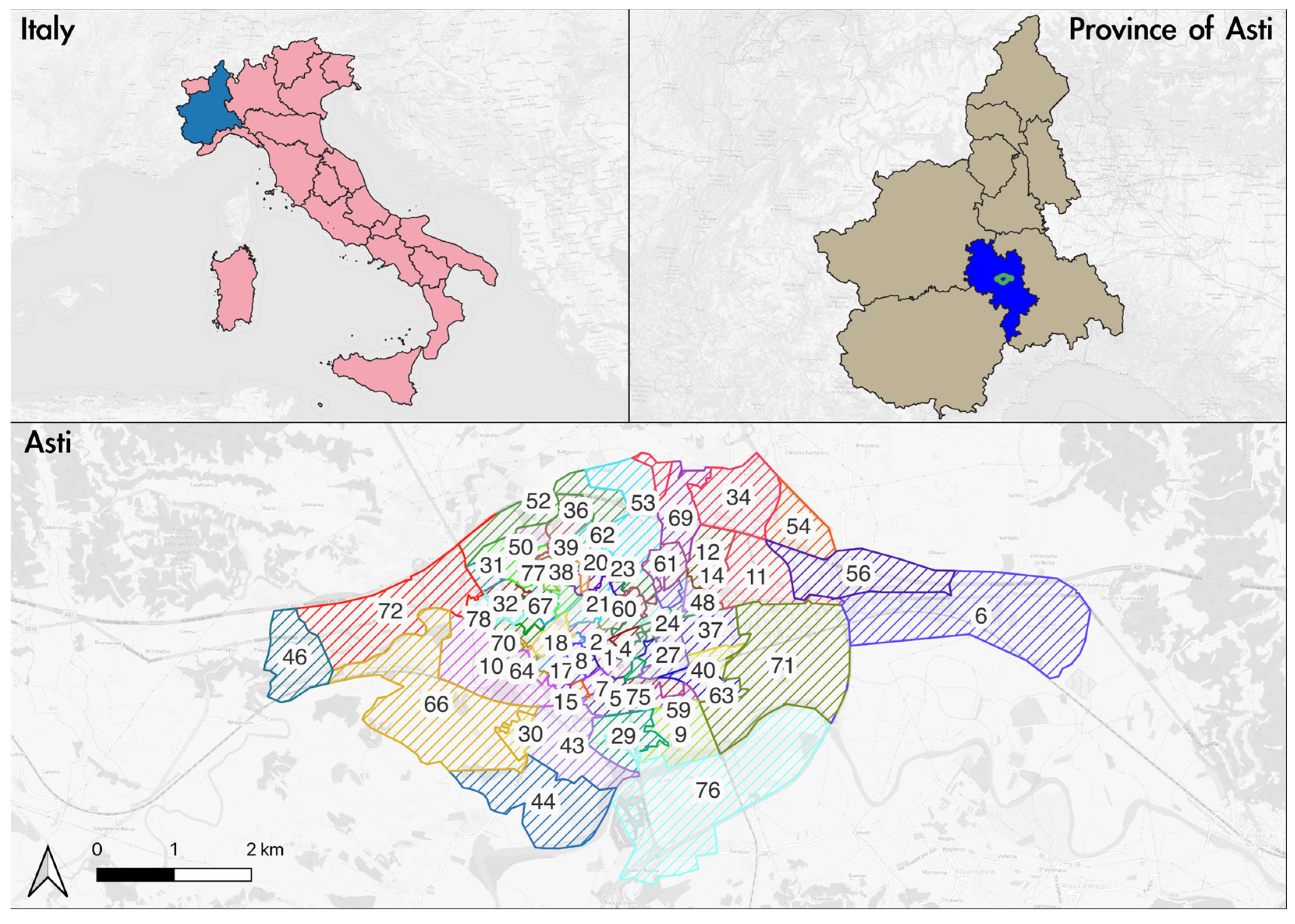
Based on the aforementioned concepts, this research aims to present preliminary results that contribute to the planning of urban forestry, to support small and medium-sized administrations. The city of Asti, which constitutes a compact urban centre with a significant Roman and medieval past, located in the northwest of Italy, serves as the case study.
The approach is based on several international recommendations for this purpose. Among the international recommendations, the most pertinent and holistic approach for this purpose is the 3–30–300 rule [
25]. One reason behind this statement is that the above rule highlights the advantages of urban forests, a less explored topic in other recommendations or similar rules [
26].
Research Aims
This research aims to identify the areas in Asti (Piedmont, Italy), which should be prioritised for UF implementation. To achieve this objective, the study adopted the 3–30–300 rule [
25].
However, applying this rule to small and medium-sized historical cities with a compact layout (i.e., Roman planning and/or with a medieval fabric) requires considering the territorial context and the municipal administration’s management of the area, especially with reference to Asti as a case study. Therefore, the authors suggest a practical application of the 3–30–300 rule, by dividing the city into electoral sections (or wards) as a functional unit, and evaluating the quality (mainly referring to NDVI values) and the health status of green spaces. This evaluation will guide the prioritisation of areas for UF implementation in Asti.
This paper presents an innovative idea of employing diverse functional units and the fact that the above rule has not yet been applied much in urban realities, especially in the compact small-to-medium sized locales with historical urban layouts of mainly Roman and/or medieval layout. This spatial unit, always referring to the administrative boundaries of the municipality, is commonly present in small and medium-sized European cities, primarily in Italy, where the concept of neighbourhood subdivision is largely absent.
Improving the living conditions of various living beings in urban realities depends not only on the presence or absence of green spaces (especially UF), but also on their quality. Thus, this aspect will also be taken into account during the modification and implementation of the regulation.
The research meets some of the Sustainable Development Goals set by the United Nations including Goal 3 (target 3.9), Goal 11 (targets 11.6, 11a and 11b), Goal 12 (targets 12.2 and 12.8), and Goal 13 (targets 13.1 and 13.2) [
1].
2. Materials and Methods
2.1. Study Area
The city of Asti (44.9° N, 8.206944° E) is located in the Piedmont region of northwestern Italy. It covers a total area of 151.31 km
2 with a population of 73,495 inhabitants, giving a population density of 485.72 people/km
2 as of 31 October 2022 [
27]. The city has an average green area per inhabitant of 12.64 m
2, which is higher than the minimum value of 9.0 m
2 per person for public areas provided for greenery, play and sport, as laid down in Italian Interministerial Decree no. 1444/1968, point 3.C [
28]. Specifically, it counts on an urban tree stock of about 12,500 specimens, of which 4500 are in tree-lined avenues and about 14,000 m of hedges, as of 2016 [
29]. The most common species are linden, sycamore, hornbeam, ash, ginkgo biloba and mulberry, including two metasequoias.
As of January 2023, the city of Asti does not seem to be divided into districts, but rather into constituencies and 78 electoral sections (or wards). Therefore, in order to carry out appropriate analyses of the urban fabric of the city, it was decided to use the electoral sections (or wards) and their respective areas (
Figure 1). The wards were discarded because in-depth studies cannot be carried out in the most urbanised part of the city.
Appendix A provides details of the voting sections in Asti to help understand their areas. This division was found to be the most efficient way to analyse the city in relatively small areas and to accurately identify risk factors and pressures. The use of electoral wards is ideal for small to medium-sized cities, including those with a historic urban layout, where there are no official administrative divisions into neighbourhoods or districts. As for demographics, as of 1 January 2022, the average age of citizens of Asti is 46.2 years, compared to 43.8 years in 2012 [
31].
Appendix B displays the different age groups into which citizens can be divided effective from 1 January 2022. As Asti is indexed by ISTAT as the 75th city in the country in terms of population residing in the main city [
32], this method has the potential to be replicated in another 7826 Italian municipalities, out of a total of 7901, as per data updated on 1 January 2023 (ibid.).
2.2. Research Methodology
This study proposes a review of the application of the 3–30–300 rule to compact small and medium-sized towns and cities with a strong historical background that feature Roman planning and/or have a medieval fabric. The rule, which actually has a guideline nature, suggests that each resident should have a view of at least three trees from their residence, each neighbourhood should have 30% tree cover and the nearest premium public green space (of at least 0.5 hectares) must be within a 300 m radius.
The next paragraphs will detail all datasets used in this experiment. To encourage replicability of the experiment in other cities, the data refer to publicly available geospatial datasets or those provided directly by the public administration. The analyses were conducted using QGIS 3.x, an open-source, cross-platform desktop geographic information system. All data used are from the year 2018.
Analyses were conducted at both city level and the level of electoral sections (wards). At the qualitative level, findings were classified into five categories: very low, low, medium, high, and very high. This subdivision facilitated a simple and intuitive comprehension of the data, providing a clear framework for comparing and categorising different variables. One of the key objectives of this approach was to share the final analysis with the public administration and decision makers, such as urban planners or policy makers, and assist them in making data-driven decisions. This was achieved by using descriptive terms such as ‘very low’, ‘low’, ‘medium’, ‘high’, and ‘very high’, which make it easier to communicate the results to a wider audience. These featured categories provide a common language that is easily understandable and relatable to by the audience, even if they are unfamiliar with the technical specifics of the analysis. This study aims to highlight how the 3–30–300 rule serves as a useful guideline for policy and planning purposes and stimulates debate about urban greenery and UF. Furthermore, this rule can be applied in various urban cities to analyse the status quo and develop future strategies for increasing or maintaining UF. It is important to note that the primary focus of this study is not to compare results between different cities but instead to analyse differences within the same one with the aim of reducing possible social inequalities [
25].
The area analysed does not include the agricultural, wooded, and hilly areas surrounding the built-up zone, as their management is often entrusted to private owners and the remaining public spaces are managed differently in urban areas. This decision was made after the authors conducted three visits to the city in October 2022, and February and June 2023.
2.3. Three Trees per Building
The 3–30–300 rule also includes an analysis of the number of trees in the vicinity of each building. For this purpose, the building data were extracted from the open geographic database OpenStreetMap, while the tree map was collected from the publicly available Territorial Information System (SIT) of the municipality of Asti [
30]. In this case, the tree data refer to the census carried out by the municipality or commissioned experts and not to the actual number of trees in public and/or private areas.
Combining the building location with the tree location, we proposed to analyse the presence of trees in a 30 m buffer around each building in the city of Asti. The distribution of tree species at the urban scale was analysed using the buffer function available in the QGIS geoprocessing tools, using the distance of 30 m from each building. Specifically, for each building, we searched for nearby trees by looping through all the trees in the area and calculating the Euclidean distance between each tree and the building location. A tree was considered to be close to the building if the distance was 30 m or less.
For the analysis of the electoral sections or wards, zonal statistics were carried out on a raster file, using as a reference vector the territorial division into electoral wards downloaded from the portal of the Municipality of Asti.
The average was used as a parameter for the analysis of the zonal statistics. The data were divided into five classes, comparing the values of polygons with at least three trees and the number of buildings in the polygon.
2.4. % Tree Canopy Cover in Asti
To calculate the tree canopy cover in the municipality of Asti, the data available in the Pan-European High-Resolution Layers—Forests (2021) were used, in particular the 2018 data on tree cover density at 10 m resolution (ranging from 0–100%). For this data layer, the main sources are (since the 2018 reference year) Sentinel-2 and Sentinel-1 satellite imagery, in which the TCC of tree species in both public and private areas has been considered.
For the urban analysis, the values have been thematised in equal 10% intervals. For the electoral area analysis, the mean values inside the electoral district have been computed and thematised by dividing them into five intervals.
2.5. Distance between Buildings and Parks
The 3–30–300 rule requires an analysis of the distance between buildings and green spaces (within a radius of 300 m) with a minimum size of 0.5–1 ha. This size is derived from studies and recommendations of the World Health Organization [
33].
The data for parks and gardens refer to the census of public green areas provided by the municipality. Therefore, the analysis does not take into account both private areas and green areas designated for other uses, such as agriculture.
The data were obtained from the SIT of the Municipality of Asti and then processed at the level of city and electoral sections (wards).
For this purpose, the distance between each building and the nearest mapped green area was computed. The distance to nearest hub algorithm, available in the Processing Toolbox in QGIS, was used for the calculation. The algorithm, which takes an origin (i.e., the building) and a destination layer (i.e., green areas), calculates the distance between the origin’s features and their closest destinations. The distance calculations were based on the centre of features. Afterward, the average distance was extracted at the level of electoral sections (or wards) using zonal statistics.
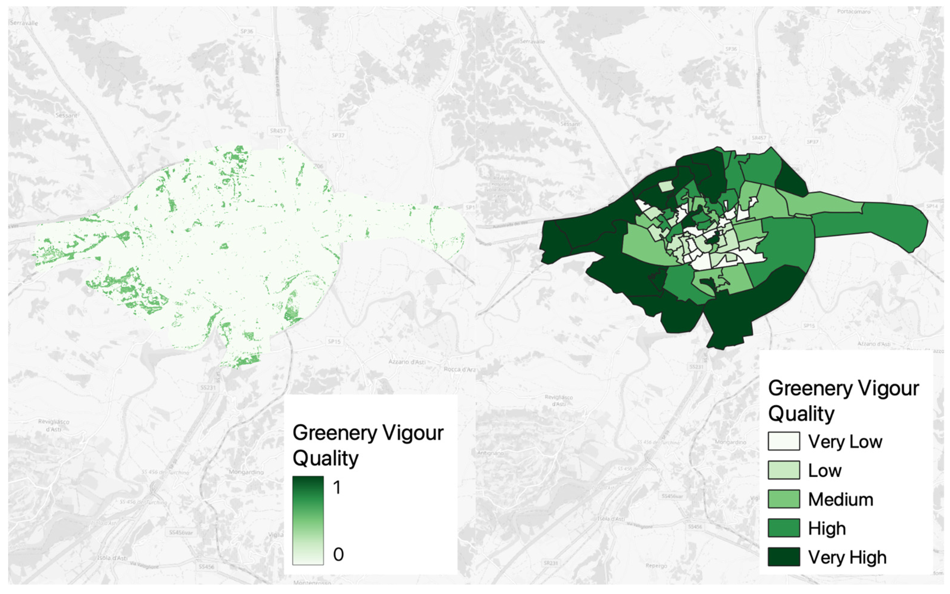
2.6. Quality of the Green Spaces in Asti
To assess the quality of the green spaces in Asti, the Normalised Vegetation Vigour Index (nVVI) [
34] was computed and analysed by the authors. The authors generated the layer utilising a time series of Normalised Difference Vegetation Indexes (NDVIs), which were calculated from Sentinel-2 satellite images to assess the greenery vigour. This was achieved by analysing the phenology of the area and its relation with trees’ growth and health. For every date during the cloud-free periods in 2018, NDVI maps were created using the Sentinel-2 data. The NDVI profiles were regularised applying splines with a time step of five days. Subsequently, they were filtered by FFT with the aim of minimising local fluctuations and emphasising the periodicity of the phenological trend. The Start of Season (SOS) and End of Season (EOS) were calculated at the pixel level using a 2nd derivative approach. The annual NDVI integral was then computed, and divided by the length of the growing season, to obtain an integrated NDVI. An integrated NDVI map was generated for the year 2022 with a Ground Sample Distance (GSD) of 10 m. The average integrated NDVI value for the given tree areas was computed using zonal statistics. The integrated NDVI was normalised to a range [0–1]. It was assumed to be a predictor of tree decline, with a value of 0.5 used as the threshold for distinguishing between potentially declining trees and healthy ones. Finally, the range of [0–1] was divided into five equal intervals.
3. Results
This section presents the results obtained from analyses conducted at the city level and electoral section (or ward) level.
3.1. Three Trees per Building
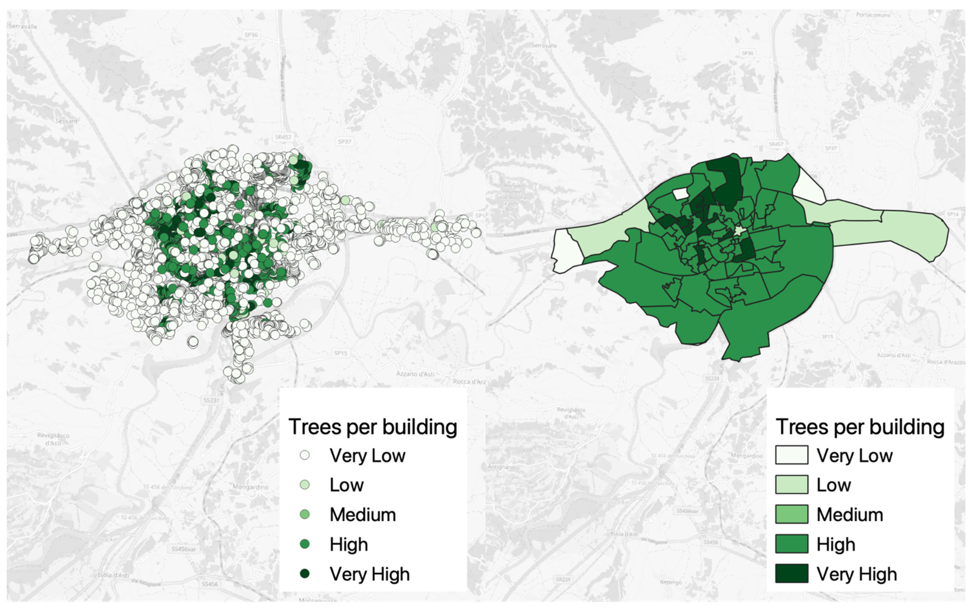
The findings display the occurrence of tree species within a 30 m radius of each building in the urban area of Asti (
Figure 2). The findings have been categorised into five classes (from ‘Very Low’ to ‘Very High’) at the electoral section level.
The left-hand map identifies the buildings with colours indicating the classification according to the number of trees within a 30-m buffer. Precisely, the ‘High’ category represents buildings surrounded by over three trees, the ‘Medium’ category corresponds exactly to three trees, and the ‘Low’ class stands for containing fewer than three trees.
On the other hand, the map on the right illustrates the analysis conducted within the voting sections (or wards), using the aforementioned intervals. This classification considers the number of buildings, electoral wards, and their respective average scores.
The study results indicate that 64 out of 70 electoral sections (or wards) had an average of at least three trees per building, demonstrating a high tree density throughout the surveyed areas.
3.2. % Tree Canopy Cover in Asti
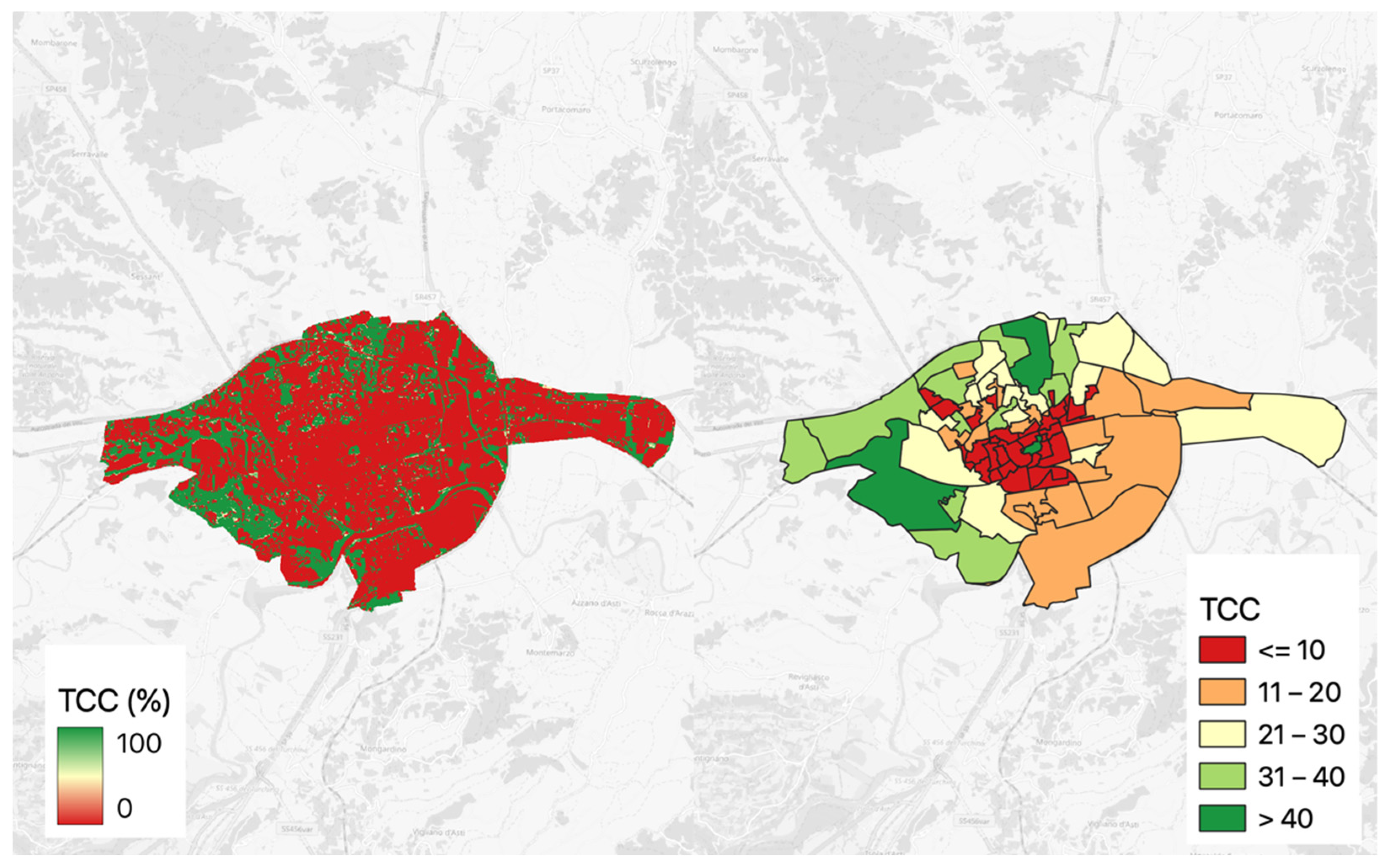
Figure 3 shows the percentage of tree canopy cover (TCC) in the city of Asti. The results have been divided into five classes, ranging from ‘Very low’ (≤10%) to ‘Very high’ (>40%), based on the electoral wards.
Figure 3’s left-hand side displays the TCC values for Asti. In contrast,
Figure 3’s right-hand side analyses the spatial unity of electoral wards and displays the TCC value division into five classes, which comes from a subdivision into equal quantiles. Electoral wards’ values range from roughly 0.6% to about 55%.
3.3. Distance between Buildings and Parks
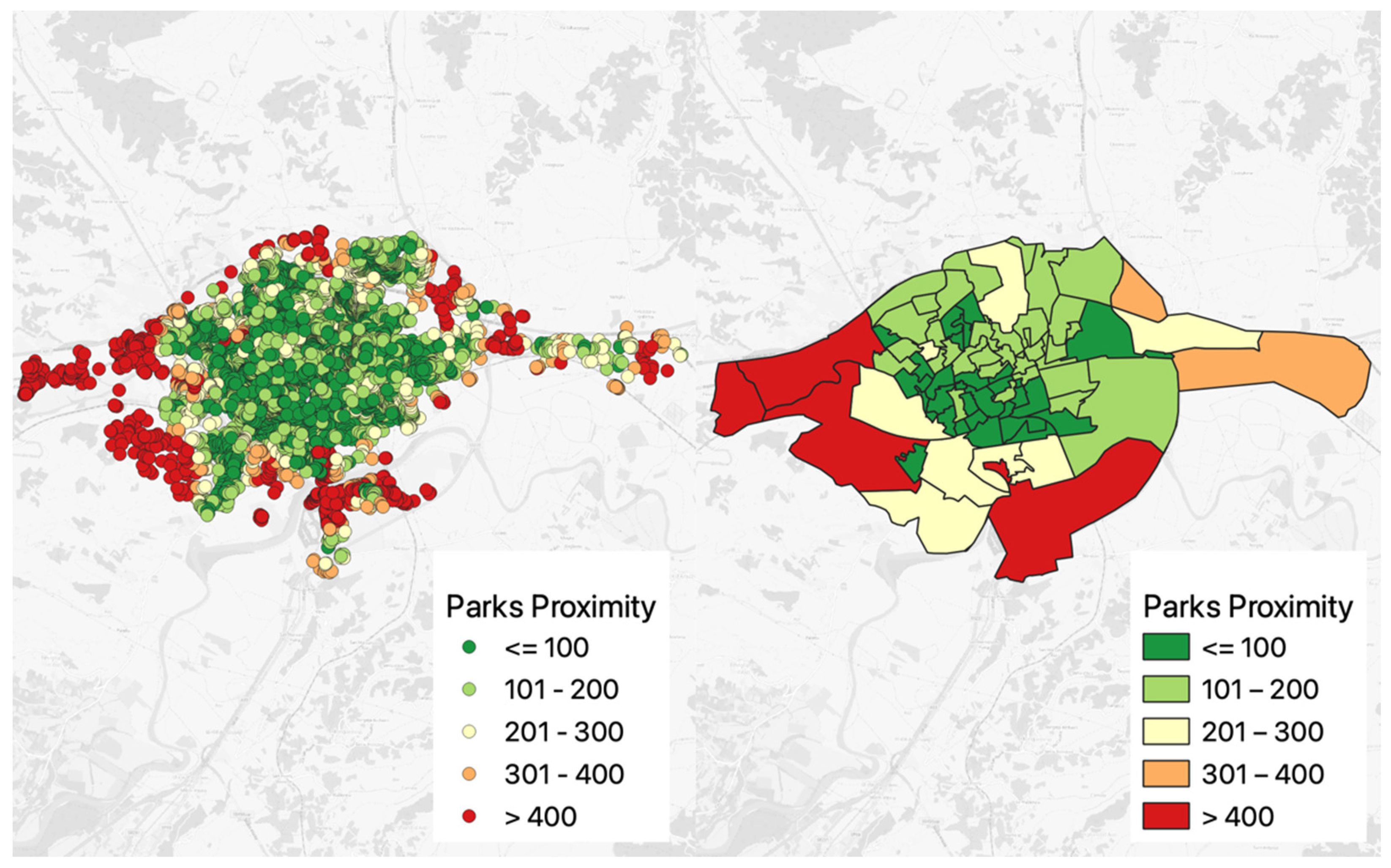
The results concerning the distance of buildings from green areas in Asti are presented below, considering a radius of 300 m and a minimum size of green area of 0.5 ha (
Figure 4). The analysis of this parameter was conducted at both the city level and the electoral section (or ward) level. Specifically, the analysis utilised the map of publicly owned green areas provided by the Territorial Information System (SIT) of the Municipality of Asti.
Figure 4 shows the proximity map results at the city level on its left-hand side. The division into five classes adheres to the following intervals: ‘Very Low’ (greater than or equal to 400 m); ‘Low’ (from 300 to 400 m); ‘Medium’ (between 200–300 m); ‘High’ (from 100 to 200 m); ‘Very High’ (less than or equal to 100 m). The classification for the electoral sections (or wards) was the same.
The results indicate that 64 out of 70 electoral wards satisfy the requirement of having at least 0.5 ha of green areas located 300 m away from buildings. However, 56 electoral wards fail to meet the 3–30–300 rule parameter. The primary reason for non-compliance is the requirement of a minimum 30% tree canopy cover. The size of the areas located far from the city centre is a significant factor contributing to the non-compliance with the 30% tree canopy cover rule. The aerial sizes of these regions are larger than those of the central areas, which makes it more challenging to achieve the desired canopy cover. Furthermore, some wards may have an adequate number of trees, but often they do not meet the required canopy-cover value due to their youth and size. Juvenile trees have less canopy cover and require time to grow, thus diminishing their overall contribution to the total canopy cover. Moreover, smaller or elongated trees cover less surface area, further affecting the achievement of the target canopy-cover percentage.
3.4. Quality of the Green Spaces in Asti
Figure 5 below displays the results regarding the quality of green spaces. The results at the urban level were categorised into five classes, ranging from ‘Very low’ to ‘Very high’. The results indicate a significant variation in green quality among different areas. The study highlights that the areas situated more centrally have a lower to medium-low quality of green spaces.
The findings suggest that the densely populated urban areas may significantly affect the availability and quality of green spaces. On the other hand, the surrounding areas, which may have experienced less intensive urbanisation, show a gradual increase in green quality along the surrounding belt of the densely populated city centre. The observation suggests that these outer regions provide more favourable conditions for the development and maintenance of green spaces, which leads to better green quality. Overall, the results emphasize the importance of urban planning strategies and spatial factors to enhance green quality and promote a healthier urban environment in the city centre.
4. Discussion
4.1. Planning and Management of Green Spaces in Urban Contexts
The planning and management of green spaces in urban areas, with a focus on urban forests (UF), is gaining interest globally, especially in the USA and Canada [
35]. This study mainly aims to identify areas where UF can be implemented as Nature-based Solutions (NbS). Implementing NbS requires a prior assessment of the available area suitable for the specific NbS [
35]. This study presents a methodology proposed by the authors to implement NbS in medium-sized to small urban settlements, considering green quality. In response to these challenges, the authors propose implementing and adapting the 3–30–300 rule. This rule is based on the smallest spatial unit that a municipal administration can consider in Italy and Europe. Although the IUCN has proposed this rule internationally and it could have a significant impact on policy and governance, there are currently few articles describing its application or potential modifications. This is likely due to the recent proposal of the rule. This approach can also be applied in urban centres where the city centre was built centuries ago and may not have been divided into neighbourhoods. This rule applies in countries which are part of the European Mediterranean area, such as Italy, France, Spain, and Greece, as well as in some Balkan areas, such as Albania.
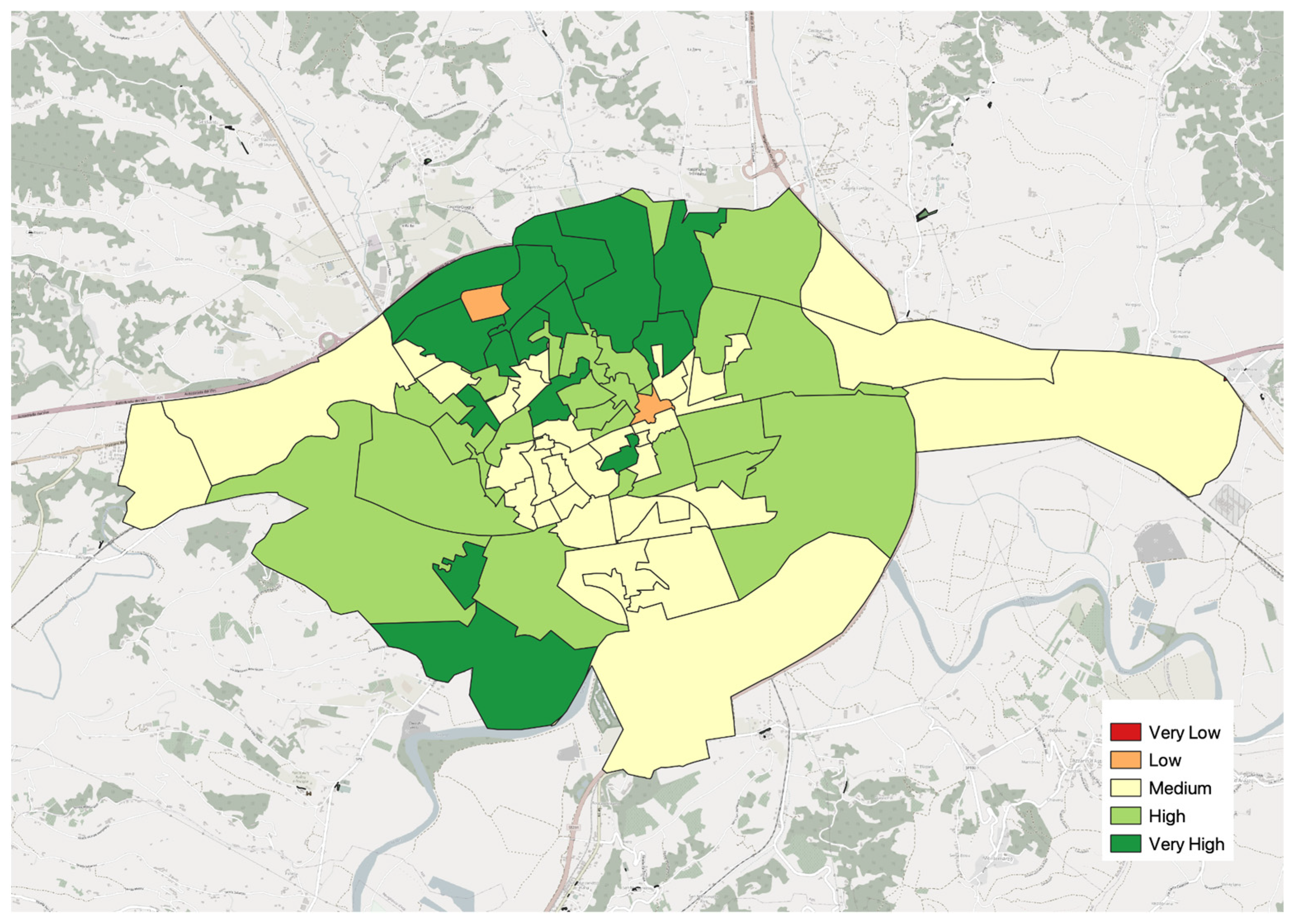
Potential areas for intervention should be identified and commented upon based on the city’s planning and the three field surveys conducted in the city’s electoral sections (or wards) in October 2022, and February and June 2023, as shown in
Figure 6. This Figure only serves as a tool to initiate discussions. Based on the cross-analysis of the data and field visits, certain areas in the south/southeast of the city of Asti have the potential to host nature-based solutions (NbS). These areas have good connectivity to the existing ecological corridors associated with the Tanaro River, the WWF La Bula Oasis and the Belangero Ponds (44.878822° N, 8.209906° E), as well as to the western region where the Special Nature Reserve of Valle Andona, Valle Botto and Valle Grande (44.9409° N, 8.1151° E) is situated. Aimar et al. (2022) also reported on the significance of the Tanaro riverbank landscape as a heritage asset, with an ongoing process to obtain a Declaration of Public Interest [
36], p. 16.
The areas to the east and west of the study location are productive farms that largely cultivate arable crops. To a lesser extent, they grow fruit trees such as hazelnut, walnut, cherry, pear, peach, mulberry, and vines, among others. These fruit plants could also be included in implementing NbS in urban areas as part of the urban food forestry framework. This should consider microclimatic conditions and climate change scenarios. However, it is important to ensure that the fruits of these plants do not affect pedestrian and cycle paths and car traffic or compromise the cleanliness of public spaces.
These theoretical recommendations may assist the administrative and political managers of the Public Works, Urbanism, and Planning and Environment sectors in the Municipality of Asti in developing interdisciplinary strategies and actions to implement and establish new initiatives in different wards. Conducting such a study may aid in complementing the development of an Urban Greening Plan and Greening Regulations, which are currently absent in the municipality of Asti.
Currently, there is only a 2014 Census of Urban Green, last updated at the end of 2015, available from the former Green Office, which is not presently online. Moreover, there exists a potential discrepancy in the categorisation of neighbourhoods between the Green Census which classifies them based on the park grass-cutting contracts, and the Urbanism and Planning Sector of the Municipality of Asti. Currently, third-party organisations appear to be responsible for conducting this census, as the operations of the said office have been discontinued. Since March 2021, representatives of the local administrations and the provincial professional associations (Order of Agronomists and Foresters, Order of Architects, Planners, Landscape Architects and Conservationists, Order of Engineers, College of Agrotechnicians and Graduate Agrotechnicians, and College of Surveyors and Graduate Surveyors) and the third sector (Legambiente, Cittadinanzattiva Asti, Forum Salviamo il Paesaggio, Associazione Terra, Boschi, Gente e Memorie, LIPU Asti, Landscape Observatory for Monferrato and Astigiano, and WWF Asti) have worked together on a draft Urban Greening Plan and Greening Regulations, but these documents were never adopted.
4.2. Comparisons with Other National and International Cases
The 3–30–300 rule indicates that the number of trees and tree canopy cover are crucial indicators to plan new UF spaces in cities. The Senseable City Lab of the Massachusetts Institute of Technology (MIT) is known for its analyses of these parameters. They pay particular attention to measuring the tree canopy cover (TCC) of cities among various tools and studies. The TCC of London (12.7%) has been compared to that of New York (13.5%) and Amsterdam (20.6%) in the MIT study [
26]. The city of Turin was analysed in Italy, and its TCC value was found to be 16.2%. However, data on TCC for small and medium-sized cities are currently unavailable. However, Asti TCC, with a value of 25.7%, shows a deviation of 9.5% from Turin, the first Italian capital. The paper’s findings demonstrate that the Pan-European High Resolution Layers—Forests data analysis resulted in a tree cover value for Asti. Hence, the utilisation of diverse techniques and resources might produce slightly varying results and, consequently, exhibit divergences in the regions suitable for UF implementation. Different methodologies have been adopted in the debate on the implementation or upscaling of NbS in urban settings. Planting tree species with European case studies is one of the most frequently used techniques, and scenario analysis techniques are vital in this regard [
37,
38]. Our research is not a replacement for these analysis techniques, but rather a method to be performed in advance or in conjunction with other methodologies.
The initial findings of this study emphasise the quantity of trees surrounding buildings. Nonetheless, there is no evidence of whether they can be seen from the houses nearby. The next step in the research could involve an accurate evaluation of this aspect, as has been attempted in other similar studies [
39]. Despite this, it was chosen to utilise the data supplied by the city council. This approach may encourage the collection of green data in areas where they are lacking and also facilitate the comparison of data from different municipal administrations in Europe and Italy. It is important to note that the aim is not to promote a ‘Green Olympics’ but to initiate a discourse on greenery and analyse the condition of greenery, particularly the UF, to prioritise areas of the city in need of resources and attention.
While the number of trees around buildings in the central part of Asti is discrete, the TCC values tell a different story. This outcome may be attributed to the tree species and their age, considering that only trees planted prior to 2018 were evaluated, making them at least 5–6 years old. It could also be because of the health of the tree species or management activities such as pruning. Studying this aspect would be valuable to create a more accurate connection between the characteristics of different species and the provision of specific ES in Asti. This has already been conducted for Turin according to reference [
40].
The study’s results on the distance between buildings and green spaces enable comparisons with other cities. For instance, in Sheffield, green areas are less proximate [
41]. Conversely, in Berlin and Łódź, there are large green spaces nearby residential areas [
42].
Maintaining green quality is critical, especially for tree species that are prone to dying or decaying over time. Furthermore, not all plant species thrive after being planted. According to a 2015 study, around 67% of the trees planted in the Million Trees Los Angeles programme did not survive [
43]. An earlier study covering southern Berkeley to western downtown Oakland in California revealed that 34% of trees died within the first two years of being planted [
44]. It additionally suggests that trees near housing and public green spaces have a higher mortality rate than those near single-family houses and rapid transit stations [
44].
4.3. Further Steps
Some scholars have reported that the enhancement of UF as NbS in urban areas can have advantages for managing air pollutants, notably microparticles (MPs) [
45,
46,
47].
The 2022 report of the Italian National System for Environmental Protection (SNPA) identifies critical environmental concerns for the city of Asti. The report anticipates that the city will exceed the daily average limit of 50 µg/m
3 over a significant number of days. Specifically, the two stations located at Baussano Nursery School and Salvo D’Acquisto Primary School are predicted to exceed the limit for 75 and 43 days, respectively [
48]. These values should not exceed the limit more than 35 times per year. The annual mean levels of particulate matter with a diameter of 10 µm (PM
10) at the stations mentioned are quite high, measuring 37 and 30 µg/m
3, and they exceed the annual limit of 40 µg/m
3 [
48]. With respect to ozone (O
3), there were 58 days in which the long-term objective for the protection of human health was exceeded, which is higher than the maximum of 25 days [
47]. The significance of these levels should be analysed thoroughly, taking into account not only the short term but also the medium term, in relation to the new limit values proposed by the European Commission in Directive 2008/50/EC of the European Parliament and of the Council on ambient air quality and cleaner air for Europe, which will come into effect on 1 January 2030 [
49], and the World Health Organization guidelines [
33]. A daily limit value of 45 µg/m
3 is proposed for PM
10, which should not be exceeded more than 18 times in a year. Additionally, a threshold value of 20 µg/m
3 is proposed [
33]. Legambiente reports that the average annual variation (%) during 2011–2021 for PM
10 and nitrogen dioxide NO
2 is only −3% and −5%, respectively [
50]. It confirms that in order to comply with the new limit values scheduled to be introduced at the EU level from 2030, a reduction in concentrations (%) of −39% for PM
10, −50% for PM
2.5, and −11% for NO
2 (ibid.) will be necessary. Based on the above data, there is a risk that it may take 130 years to meet the 2030 limit values for PM
10 and 22 years for NO
2, if the ten-year ‘business as usual’ trend continues.
To achieve this end, Sofia et al. propose “… the implementation of a strategic plan focused on reducing multi-pollutant emissions” [
51], aligned with the call to “… prevent pollution” by identifying “… key urban greening and innovation needs” (ibid.) under “Flagship 2: Supporting urban zero pollution action” [
49]. Despite the critical issues identified above and the urgency for action, the current response to mitigation seems insufficient.
In addition, the city experienced the “… occurrence of a good number of dead/felted or decaying trees in two local avenues” (i.e., in Corso Torino and Corso Matteotti) [
47], totalling 126 out of 407 specimens (about 31%) in March 2019. Additionally, the urban air-pollution monitoring station present at the Baussano Nursery School is located within an area having a very low tree canopy cover, ranging between 0 and 4.9% (
Figure 3). It can be concluded that the current state of urban green infrastructure is inadequate and requires additional measures to include all expected features, before any considerations can be made to improve its quality and quantity with different plant species. Selected tree species such as Curly Maple (
Acer platanoides), Warty Birch (
Betula pendula), Turkey Oak (
Quercus cerris), Ginkgo biloba, Native Lime (
Tilia plathyphyllos), Bagolaro (
Celtis australis), Wild Lime (
Tilia cordata), the Common Elm (
Ulmus minor), the Common Ash (
Fraxinus excelsior), and the Black Alder (
Alnus glutinosa) should be chosen for their higher capacity to stock CO
2 in tons over 20 years (ranging from 3.8 to 2.6 tons depending on the species), as well as their ability to mitigate gaseous pollutants and particulate matter (medium/high/high) [
50]. The species mentioned above require evaluation in terms of their susceptibility to climate change impacts and the transmission of plant diseases over time.
It is important to note, within the context of this work, that the authors did not propose a multicriteria framework for implementing Nature-based Solutions. This could be a potential area for future research. The 3–30–300 rule is not easily applicable for benchmarking practices due to its lack of predetermined standards, thresholds, or best practices. Additionally, the application of benchmarking methodologies in small to medium-sized historical cities is challenging due to unique characteristics and spatial constraints inherent in these urban contexts. This study aims to initiate a discussion on integrating green elements in small to medium-sized cities with distinctive historical structures, while also considering the administrative subdivisions that exist in any urban setting. Integrating the concept of green quality into the regulations facilitates identifying areas in need of attention for green space management and determines suitable sites for implementing Urban Forests.
Finally, it may be beneficial to closely examine and differentiate between districts within cities, where differences in environmental conditions, particularly the heat island phenomenon, can be observed. For this purpose, different software tools such as InVEST, ENVI-met, and Space Syntax can determine these differences.
5. Conclusions
The present research suggests implementing the 3–30–300 rule as a tool to identify areas in compact small- and medium-sized towns and cities with a strong historical background (i.e., Roman planning and/or with a medieval fabric) that require Urban Forestry (UF) implementation. The selected case study examines the city of Asti, located in Piedmont, north-west Italy. Geospatial datasets have been used and processed through QGIS, an open-source, cross-platform desktop geographic information system. As there is no formal division into neighbourhoods, the analysis predominantly focusses on qualitative assessments of the electoral sections (or wards), into which the city is divided.
This analysis involves evaluating the quantity and distribution of trees around each building, measuring the canopy cover, and determining the distance between the buildings and nearby green spaces. According to this study’s findings, among the 70 analysed electoral sections, 64 have an average of three or more trees per building. Furthermore, these areas have sufficient green spaces, measuring at least 0.5 hectares and located within a distance of 300 m from the buildings. Additionally, the research indicates that the canopy coverage of the electoral sections differs, with the minimum percentage being about 0.6% and the maximum being around 55%. The findings imply that the densely built-up nature of these locations considerably affects the availability and quality of green spaces.
To conclude, this case study presents empirical evidence supporting the effectiveness of implementing the 3–30–300 rule in compact small and medium-sized urban areas with ancient Roman foundations and significant medieval layering. The study adopts an integrated evaluation approach that combines nature-based solutions (NbS) and ecosystem services (ES), emphasising the utility of this approach in tackling urban forestry challenges. In addition, the paper establishes strong connections between various fields, including agronomy, botany, and planning, in order to identify the characteristics and types of nature-based solutions, as well as the significance of ecosystem services in urban environments. The evaluations conducted in this paper may help improve the well-being of citizens in densely populated urban areas to mitigate the impact of climate change and the resulting urban heat island phenomenon.
Regarding the limitations of the research, the study includes a small sample size, which requires further validation through comparison with similar case studies. Validation of this research can be achieved by combining desk studies with on-field surveys and applying the implemented 3–30–300 rule in other small and medium-sized urban contexts in Italy and Mediterranean European countries. This study only employs data derived from remote sensing. There is no use of socio-economic data, such as population estimates. Remote sensing data are derived using mathematical methods reported in the literature, and thus not expected to have any bias. Thus, the current research should be regarded as an alternative interpretation of the 3–30–300 rule. This rule is a guideline, and consequently, does not have any clear-cut methods. Hence, it leaves room for interpretation. These findings have prompted the authors to reflect on the analysed case study, specifically the city of Asti, Italy. Furthermore, it is hoped not only that the census of tree species will be continuously updated, but also that an assessment of the multiple ecosystem services provided by the plant component in the city will be carried out, in a strategic effort to plan for the needs of both humans and more-than-humans [
52]. Regardless of the many directions future research might take, it is hoped is that the issue of managing and co-existing with green spaces will always be considered. Finally, these outcomes can be compared with those obtained from other software to determine the significance of urban heat islands and potential solutions at the urban level in public spaces.


