1. Introduction
In urban ecology, green spaces are defined as unsealed pieces of land with permeable soil that hosts grass, trees, and shrubs. However, several studies proved that in urban areas, particularly in developing nations, the provision of green spaces is a challenge due to several social, economic, ecological, and geographical issues [
1]. This phenomenon related to the difficulty in maintaining green spaces is different from region to region and from time to time. Different approaches have been developed in urban ecology and urban planning science; therefore, the current definition of green spaces includes vegetated and non-vegetated sites, spawning from grasslands to urban parks, even from dense wooden covered patches to green grasslands and playgrounds.
From an urban sustainability point of view, green spaces are globally considered by all human cultures as natural ornaments, capable of increasing environmental pleasantness in urban areas [
1]. From the scientific perspective, these spaces are considered the most relevant element for heightening the environmental quality and safety in the cities. Green spaces provide several ecosystem services by improving air quality, providing protection from wind and rain erosion, supporting biodiversity corridors and stepping-stone connectivity, reducing noise, and acting as cooling spots in the dense network of settlements [
2,
3].
It has been shown that pollution in cities tends to decrease due to the presence of shady trees, flora, grassy lawns, and parks; therefore, the quality and quantity of green spaces are valuable elements for urban resilience in an urban ecosystem, which indirectly improve the life quality in urban areas [
4].
Several studies on green spaces have also shown positive effects on human, social, and economic development, unfolding in different dimensions [
3]. The presence of accessible green spaces in a city ensures to increase the rate of recreational opportunities, improves restoration from mental stress, enhances social engagement and cohesion, and finally supports the population’s well-being and sense of belonging, which is a snapshot of environmental justice [
3]. Eventually, the inherent cultural and aesthetic values of green spaces near buildings and properties often increase their sales market, as demonstrated worldwide [
5,
6,
7,
8,
9].
Nevertheless, it has been investigated that in several countries, urban development is harnessing a huge quantity of natural resources and destroying the beauty of the landscape, which often becomes exceptionally harsh in some cities and suburban areas [
10]. Throughout the developing world, urban green spaces, parks, playgrounds, and gardens are disappearing due to the feverish construction of residential buildings, industries, and business centers in the countries, leading to many ecological and environmental issues [
11].
Moreover, the fast replacement of vegetated spots with infrastructures and buildings has been associated with the spreading of diseases among urban citizens [
12]. Therefore, healthy and green cities should be the criteria to ensure a healthy population [
13].
Unfortunately, the urban population is growing very fast, particularly in developing countries [
14], and a reasonable urban development plan is not always timely provided. As a result, the low-income part of the population often lives in poor housing conditions, without urban green access, facing poorer life quality [
15].
Ref. [
11] reported that indeed, not only the presence of greenness is important, but the accessibility to it is also a key factor for an ideal living space, even in cities rich in green spaces [
13]. Accessibility at walking distance is imperative for enhancing the frequent fruition of vegetated and restorative areas because it encourages more frequent short trips [
16]. This can be considered a fundamental principle for urban life quality in the context of neighborhood service [
15].
Thus, the question of where urban green spaces are located, and which types of green spaces are granted to the population groups, is crucial for planners and urban ecologists. People often desire to get away from daily life activities for stress relief; therefore, the presence and approachability of green spaces are crucial, especially in this current era. In addition, every person require different nature of green spaces, going from woods to grassy land, or from uncrowded parks to playgrounds; thus, it is important to fulfill the user’s perception during planning in land allocation [
17]. To ensure the match between residents’ needs and urban development, there is a dire need to foster scientific research on such a crucial topic, especially in developing countries.
In this study, we propose a method to monitor the distribution of green spaces, their accessibility, and the use of green spaces by local people in a highly populated suburb in Pakistan, finding several disparities in connectedness and availability of green spaces for different population groups. The final aim is to provide evidence-based results that can support urban managers in policy-making and achieving wise urban development along with regional sustainability.
2. Materials and Methods
2.1. Study Area
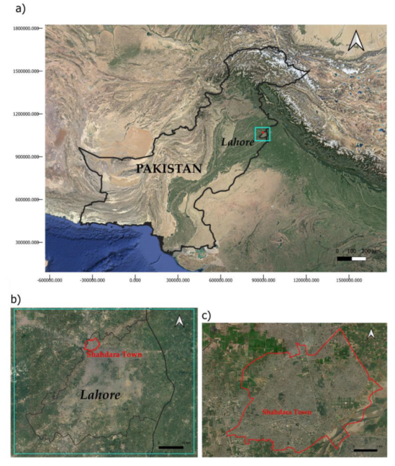
This research work attempts to quantify the urban development of Lahore by focusing on Shahdara Town, one of the most ancient Lahore’s suburbs and the one that is considered rich in historical tombs, parks, and gardens.
Lahore is the second largest city in Pakistan, after Karachi. Situated in the Northeastern part of the Punjab province, near the Indian Wahga state of Punjab, it develops straggling the banks of the Ravi River (
Figure 1).
The city’s current population is 12,188,196 inhabitants, according to the official government data. Today, the city is the second largest financial industrial hub of Pakistan, including Sadar and Kot Lakhpat Industrial Hubs, which are famous at a national level. Lahore has shifted from manufacturing to service industries [
18]. As a result, about 42% of its workforce is employed in cultural enterprises, banking, real estate, finance, and social services. The city is the country’s largest software-producing center and hosts the fastest-growing computer assembly industry [
19].
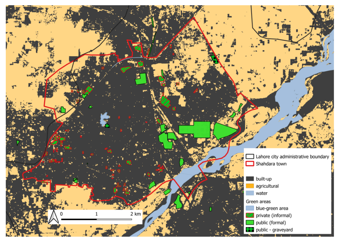
This study focused on detecting the urban green spaces in Shahdara town, in the northern part of Lahore, a very congested urban area with dense settlements and urban networks, with high population density. The study distinguishes the green spaces in two types: public parks, green belts, and green patches along the roadside, which are maintained and owned by the government, are classified as “formal green spaces”, whereas green patches in the house courtyard, green corridor surrounding the houses and patches vegetated with trees owned by private individuals are classified as “informal green spaces”. The criteria on which this classification thus refers to both the ownership and location of green spaces.
Providing green areas in congested populated areas is a fundamental element for urban development and sustainability. Therefore, this study attempts to quantify this phenomenon in terms of urban justice and to verify if there are equal opportunities to take advantage of green spaces for all the local residents of the study area. Since the population of Lahore city is still growing, which indirectly causes the degradation of natural resources and loss of biodiversity and disturbs the local ecosystem, this quantification is needed for the development of the area in terms of ecological equity and urban sustainability.
2.2. Green Spaces Geographical Analysis
Satellite imageries collected from Sentinel 2 fleet were retrieved from the SCP plugin [
20,
21] in QGIS. We chose six satellite imageries sensed during the satellite passages in spring 2021, 2022, and 2023, with cloud cover less than 10% to improve the visibility of the whole area and avoid spectral artifacts.
The average NDVI spectral index was calculated to identify vegetated patches in Shahdara town. The resulting NDVI layer was classified based on a cut-off value of 0.1, to distinguish between vegetated areas and built-up or flooded places, as this cut-off value has already proven to be effective in distinguishing between vegetated and non-vegetated areas according to previous literature [
22,
23,
24].
To detect to which the vegetated patches on the ground are devoted, the most updated geospatial data about land cover and land use were collected from the Open Street Map repository and analyzed through photo interpretation of Google Earth base maps. These were also the sources for retrieving the urban road infrastructure graph. Additional information was obtained from the Lahore district’s Parks and Horticulture Authority Act [
25]. The road network was used to run a less-cost path analysis to assess the accessibility of green spaces from different parts of Shahdara Town by walking on the road network. All the spatialized data were collected, visualized, and analyzed using QGIS 3.16 software [
26].
2.3. Population Data Analysis for Environmental Justice
Primary data about the socio-economic profile of local residents, such as age, education level, marital status, number of children, and total time spent in living in the study area were collected through random sampling surveys. We preferred to conduct the interviews with households and selected the interviewees from residents over the age of 15, with at least an intermediate educational qualification, assuming that they have sufficient knowledge of the importance of green spaces. Only local residents in Shahdara Town were selected for the interview because they visit the green spaces and parks on an average daily basis. A pilot survey was done before the primary data collection to verify whether people have access to at least one green area/park, and how green areas influence their lives. In addition to respondents’ socio-economic information, the questions covered the presence of green spaces or parks in the settlement area, their distance from home, and how they accessed the nearest green area.
Travelling costs, travel time, and time spent in the parks or green areas were also checked.
Secondary data on the population were acquired from the Statistical Bureau of Punjab, integrating with the most updated data available in the Open Spatial Demographic data and Research database [
27]. Population density and distribution data, alongside the information about the proportion of people per grid square living in poverty as defined by the Multidimensional Poverty Index [
28] (meaning for “poverty”, a situation where a joint family’s total earning is less than two dollars per day), were overlaid on the resulting layers of green spaces in the area. Subsequently, geospatial elaborations, such as the Least-Cost Path analyses and Distance Analyses through the software QGIS 3.16 with GRASS, were applied for detecting the walkable infrastructures in the study area, which highlights possible relationships between the population characteristics, settlement distribution pattern, and accessibility to green spaces. This hierarchy of methods provides a first platform for assessing a proxy indicator of environmental justice in this area. Ancillary data were also collected from Punjab Horticulture Department regarding the spatial distribution of green spaces, providing a snapshot of the land use pattern in the park’s area managed by the government, which can be related to environmental justice and provision of green infrastructure to the local resident.
3. Results
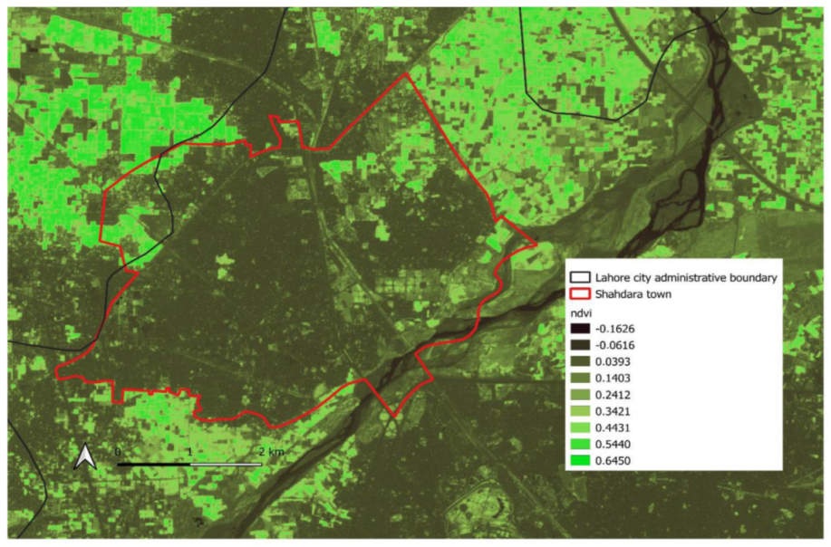
The result of the average NDVI (
Figure A1,
Appendix A) showed that, in Shahdara suburbs, 368.21 hectares are dedicated to agricultural uses. Most of this surface is located towards the administrative boundaries of the suburbs area, even if a few little orchards are also present in the town center (
Figure 2). The entire center is covered by dense urban fabric, extended for 1521.45 hectares of built-up surfaces.
Public, formal green spaces in Shahdara town cover only 99.94 hectares, whereas 68.5 hectares of other vegetated areas are privately owned. The average values on the NDVI in these spaces were on average quite low, resulting in 0.14 (±0.03 s.d.) and 0.17 (±0.06 s.d.) for private and public areas, respectively.
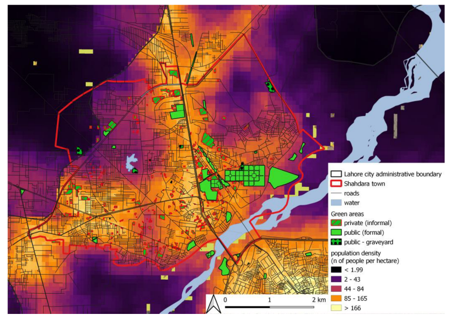
The population of Shahdara town has been expanding very fast. According to official population censuses, in 1998, the local population density was estimated at 35,516 inhabitants per square kilometre, but in 2017, the estimate was 54,530 persons per square kilometre. The distribution pattern of green spaces with reference to such a high population density (
Figure 3) shows that there are fewer formal public green spaces in areas with a high population ratio, if compared to areas with low or medium population. Moreover, the distribution is highly asymmetrical with regard to the city development pattern.
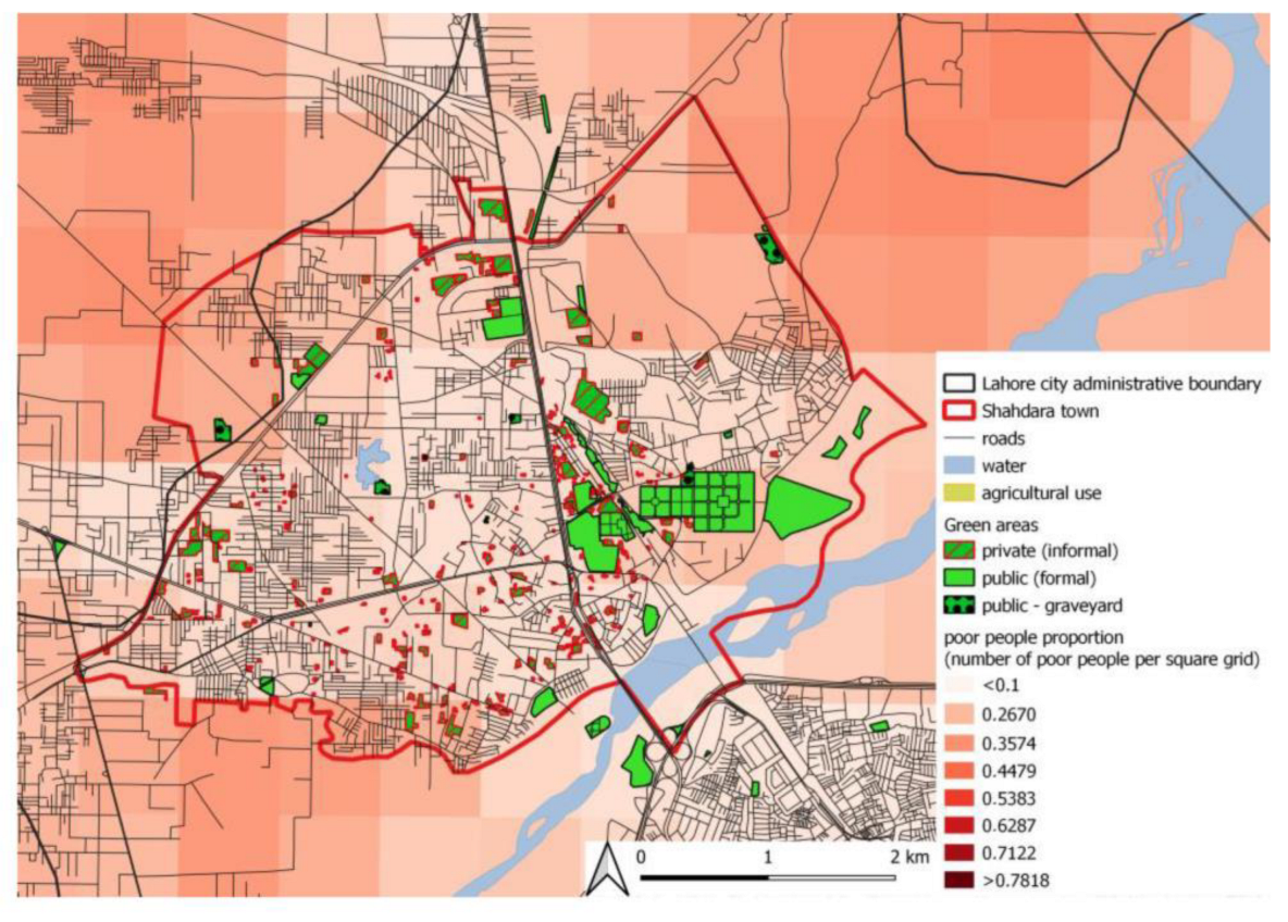
The assessment of the relationship between the green space distribution and the poverty condition is shown in
Figure 4. By analyzing the spatial relationship between the map of green areas distribution and the estimated proportion of people living in poverty as a proxy for the income level, it can be noticed that most of the green areas with a restorative and recreational value are distributed in the areas where, according to the Multidimensional Poverty Index, the proportion of poor people is lower. The majority of these areas, however, are private green areas (or informal green spaces, such as private gardens or orchards), with no public access.
Based on the results of the least-cost path analysis, at least one public park is reachable by people living in mid-income and high-income areas with a trip length ranging from 543 to 4049 m, for the southern and northern parts of the city, respectively, to be traveled on congested roads. However, little patches of private green areas, such as domestic gardens, are quite evenly distributed in the wealthier area, providing relaxation and recreational opportunities for high-income people, who indeed declared in the interviews that such green spaces are highly important for their lives.
On the other side, in the neighborhoods where the poverty proportion is higher according to the official data, the distance to the most important public green areas goes from 313 to 5633 m, with increased length for people living in the more northeastern part of Shahdara. In this case, there are no private green areas to enjoy as an alternative to the public and formal green spaces, and especially in the poorest area, the only vegetated area available is represented for the most part by agricultural patches, with a low value for recreational and cultural opportunities.
4. Discussion
In a world where more than 50% of the population has been moving within towns and cities [
27] as happened in our study area, it is very crucial to wisely plan the urban structure to meet the essential needs of the population, contribute to people’s well-being, and ensure sustainable development, as argued in the scientific literature [
29].
Even though it is widely known that green spaces offer several ecosystem services, for instance, reducing CO
2 emissions [
29], protecting biodiversity in cities [
30], and acting as hubs for outdoor activities [
13,
14,
30,
31,
32,
33], vegetated areas are disappearing in several fast-sprawling cities. This is causing several environmental, economic, and social issues. The present study brought an example of such a critical situation in an urban area in a fast-developing country. Approximately, 1/3 area of Shahdara town is under barren land. Due to unplanned residential infrastructure, green spaces are not equally available at walking distance from each of the four quadrants of the town.
Indeed, in the urban area of Lahore, the population growth and migration rate from the surrounding area is very high. As a densely populated area, Shahdara Town in Lahore is facing serious issues such as degradation of the environment, overcrowding, and unplanned infrastructure. On the one hand, people in search of jobs and aiming for improvement in quality of life moved towards this area. On the other hand, high traffic rates, air and land pollution, urban waste, and other environmental problems have been increasing along with population density, when people settle here. Due to this condition, 60% of inhabitants’ health is affected by dangerous diseases such as cholera, typhoid, hepatitis, pathologically high blood pressure, and cardiac problems due to insufficient environmental services along with basic health facilities [
34]. Moreover, existing green spaces are likely to be insufficient to control the urban heat balance, and this may be one more reason why the local people are reported to be facing different health issues related to environmental hazards [
34].
The inequalities in the green area distribution in Shahdara Town could provoke hazardous feedback that could harm even more low-income people. On the one hand, it has been demonstrated that the presence of green spaces in the surroundings of the living place heightens the opportunities for engaging in sports and leisure activities, maintaining high levels of physical activities and social engagement; on the other hand, it is now common knowledge that physically and mentally fit people work cleverly and find better opportunities in their lives [
35]. Therefore, high-income people living in luxurious city parts continue to trust the beneficial effects of the available urban green areas. The scarcity of greenness in the suburbs, mainly populated by low-income people, could prevent the low-income population from practicing sports, feeling safe, and feeling that a world is full of opportunities despite everything they are inhabiting. Preventing accessibility to green areas and related opportunities for people already in distress could lead them to an even worse mental and health condition, from which it is more and more difficult to escape.
Although the fast population growth rate in the area, the combination of an imbalanced provision of neighborhood services and poor health condition clusters is well known at an institutional level. Some previous studies associated with this crucial problem have already been identified in research works and official reports [
4], such as those from the Lahore development authority, the Municipal Corporation of Lahore, and the Local Government of Punjab. However, no pragmatic recommendations or guidelines have ever been implemented to solve the problem and, to date, the government seems to be still unable to establish new land allocations to ensure all-around sustainability.
Realizing that the problem is not easy to solve, the mapping method presented in this study can be of support in reasoning about the possible solutions in Lahore, and even in other fast-developing cities.
It has been hypothesized that government authorities should privatize at least some of the urban parks to obtain revenue from the local population and visitors and to ensure the economic resources for maintaining healthy green spaces among urban areas in development. However, our assessment shows that this measure would inevitably run up against already existing injustice problems. The need to pay for using the city’s parks could result in an additional barrier to the poor segment of the population, which is already affected by the scarce accessibility to restorative green spaces.
Therefore, we suggest that only proper planning along with local community engagement can provide the solution to this issue for the provision of services to local residents of this area. A possibility can be represented by requiring a payment proportional to the income, or by the proposal of cultural events for which the payment is requested, while on other days, access to the park is free.
An even more extensive proposal for making the spatial distribution of green spaces efficient starts with calculating how much green is needed to meet the standards suggested by WHO [
36,
37], and then ensuring that there are in the urban and suburban areas enough green spaces for the inhabitants. If at least some of these areas, in an equally distributed manner, were chosen to become shared green spaces with both horticultural and recreational purposes, a good educational intervention may achieve the willingness of the citizens to take responsibility for the care of the greenery in these shared places. This would be a way to empower citizens to take responsibility for the green areas they care about and would even increase opportunities for social interaction and networking.
5. Conclusions
Urban green spaces are important from the ecological perspective but are also crucial for society and the economy as well. Having positive health outcomes, urban green areas improve local community well-being by providing social justice [
34]. Moreover, if they were carefully managed and treasured, they act as a backdrop for the interactions between local people and visitors, becoming attractive for tourists, to generate revenue for the government as well.
The empirical finding shows that local people use public green spaces for social, cultural, and religious events [
35,
36]. Urban green structures serve as the breathing lungs for the city area, as these green islands are an important element for the urban ecosystem and biodiversity could serve as a natural habitat for different species and encourage social interactions [
37].
Likewise, the fast-growing cities of developing countries affect biodiversity and ecosystem services. The rapidly growing population ultimately has a negative impact on the local environment, with direct and indirect effects in both short and long time scales [
38,
39,
40,
41]. The analysis also suggests that people like to have parks near their houses so that they have easy access to the public urban green. Therefore, research findings indicate that green spaces in housing areas play a very vital role in the lives of people.
The results concluded that in the city of Lahore, where the rate of urbanization is very high, there is an inescapable need to plan the restoration of more parks and green areas not only within the city but also along the city boundaries to provide natural amenities and accessibility to the local people.
To conclude, we suggest that the concerned authorities should focus the community engagement by arranging cultural activities and events for promoting cultural and social inclusion, especially when involving professional staff and the use of information technologies. This will lead to improving the quality of urban life, strengthening the potential of green spaces in urban areas, and even providing tools for better land allocation plans.
This suggestion would not only serve to meet the pressing demands of the Sustainable Development Goals but could also generate interesting returns for the government itself in terms of tax and revenue. Indeed, the attractiveness of a city is often enhanced by a good distribution and management of green spaces that potentially contribute to urban renewal and enhancement of the local environment [
42]. Urban green space presence and management can strengthen the local economy through a higher local environmental quality [
43,
44]. Hence, the policies regarding the maintenance of green spaces in the city should be revised by the governments and planning authorities, taking into account ecological and social factors. The careful revision of preexisting policies might help the city government in planning the city [
45], for the future that falls within the concepts of “eco-city”, and “sustainable city” [
46,
47].
The institutional and economic tools to achieve these results in urban planning are manifold. Some of the measures that have proven effective include the privatization of parks to rebuild, restructure, and maintain the green areas in the city [
42,
48], but more importantly, the introduction of awareness programs related to the importance of green areas in the city, the engagement of citizens through the media and social networks, and the authority collaboration with urban planners, ecologists, economists, and social scientists is seen as the most promising solution to this challenges. Only by considering urban planning as a trans-disciplinary topic will build sustainable, fair, and livable cities.
The fast population growth rate suggests that the much-needed research for the future of fast-developing urban areas in Pakistan [
49] and, we dare say, also in other developing countries, should focus on a more dynamic assessment, taking into account land cover and land use change. At the present moment, historical data about land cover and land use, at a proper resolution, are unfortunately not available for Pakistan, but being aware of this problem today can help researchers in the near future, starting by collecting since now the most recent data to track the land cover and land use change while they are happening.
A good effort in monitoring and taking control of the urban changes while cooperating with local communities to take care of the environment can be the key to equal and sustainable development.


 ,
, 


