
Economic and Spatial Integration of Land-Lost Households in Inland China: Evidence from a Survey in Nanchang City

Abstract
:1. Introduction
2. Literature Review
2.1. Theories on Integration
2.2. Land-Lost Farmers in China
3. Data and Methods
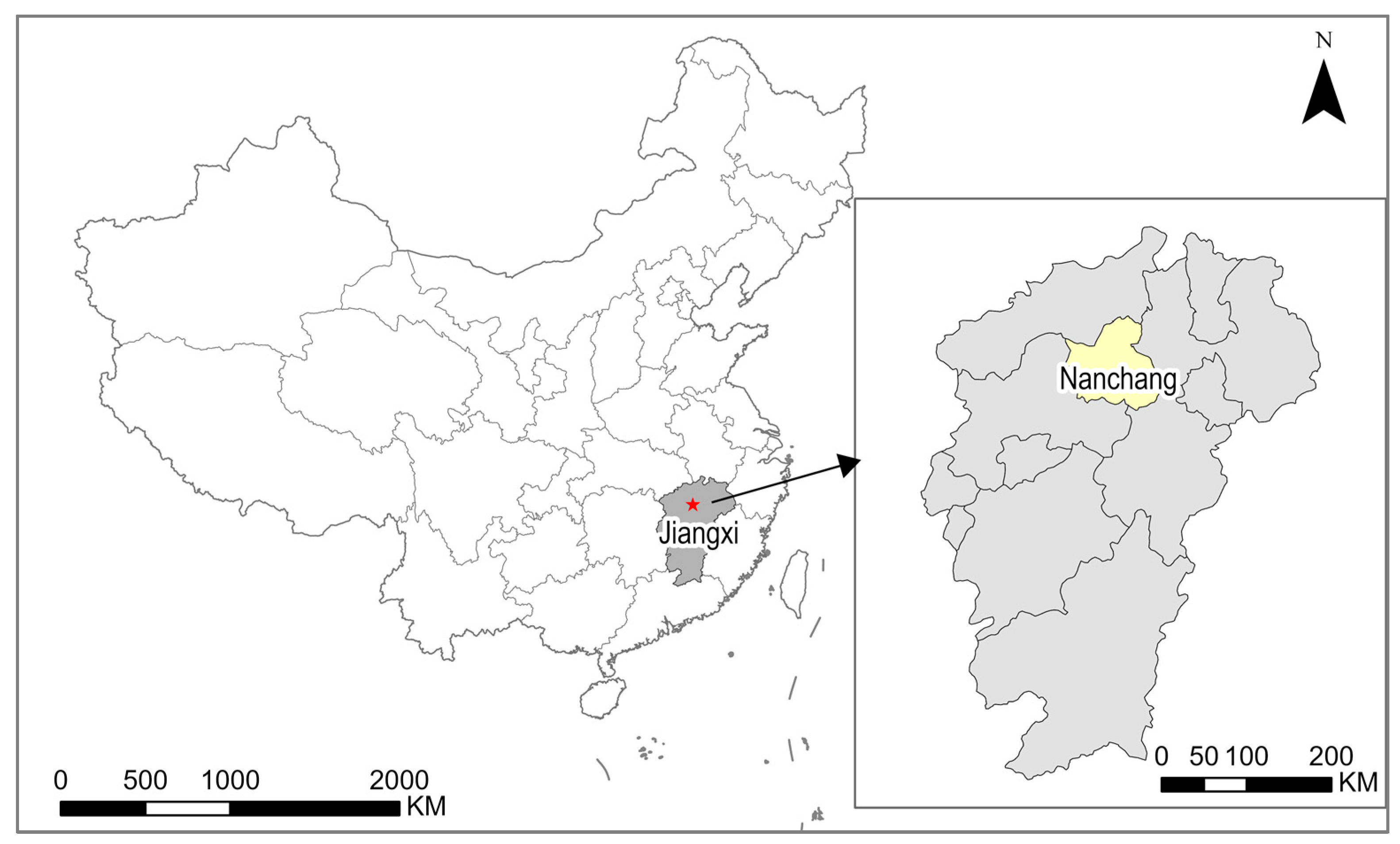
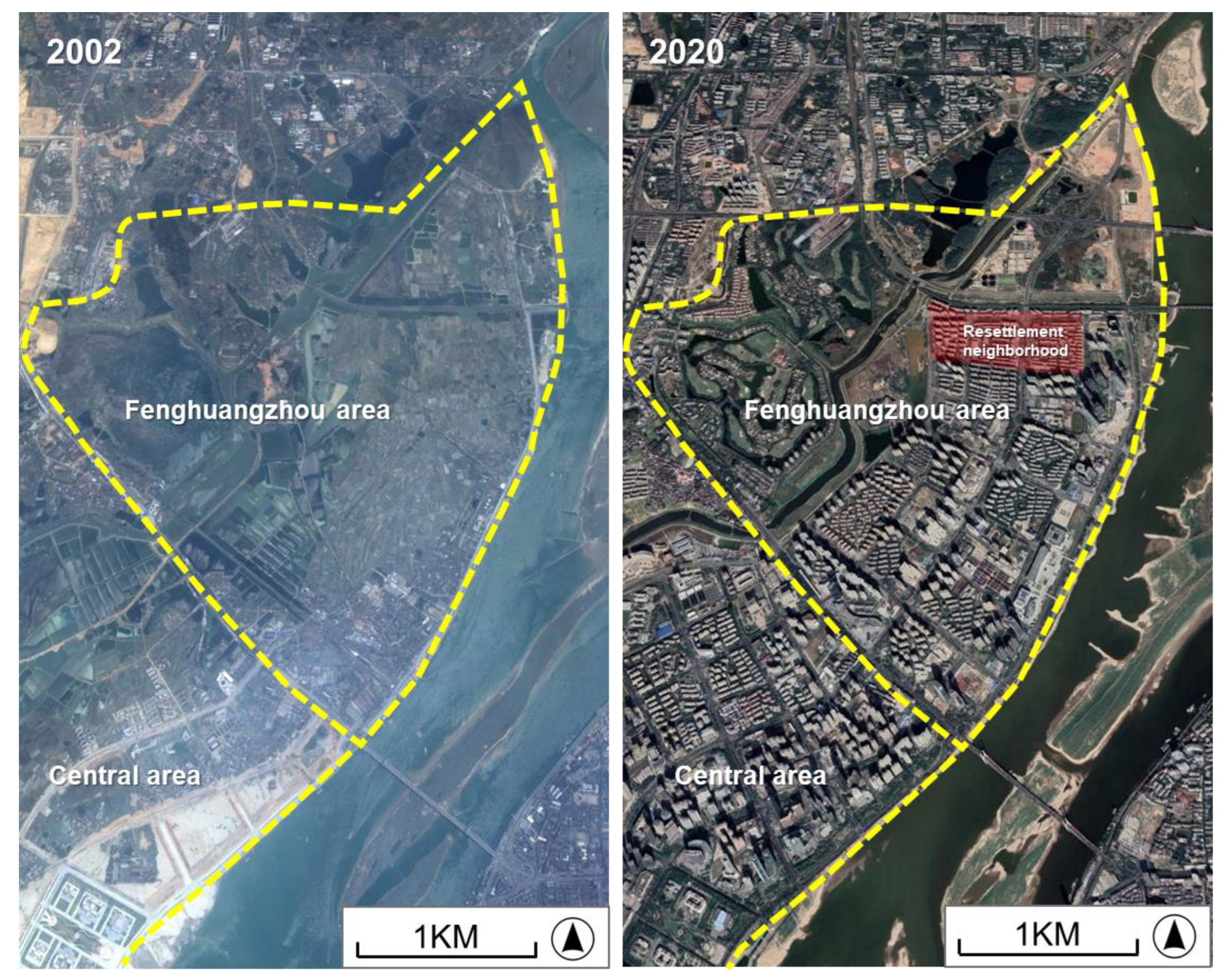
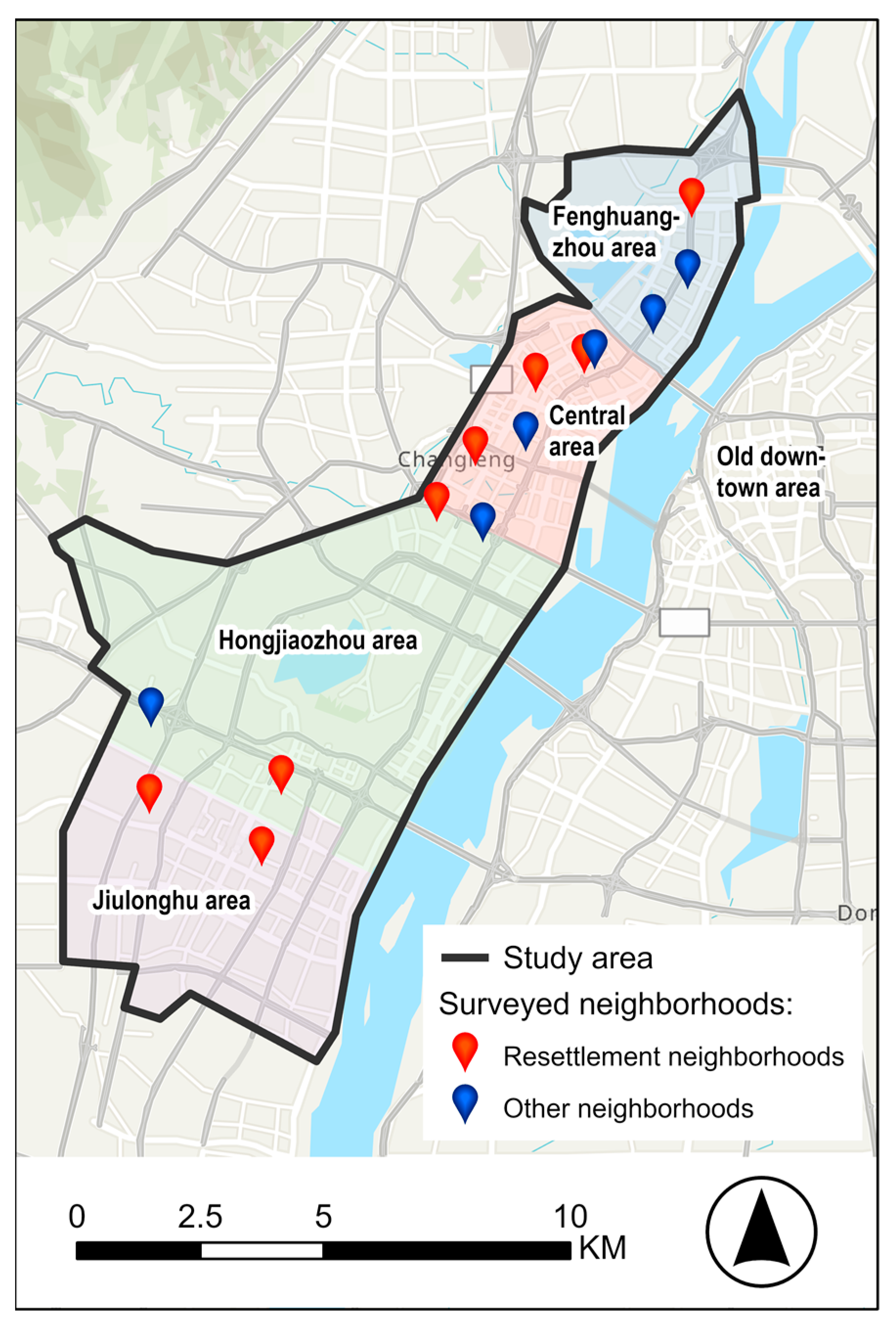
3.1. The Study Area
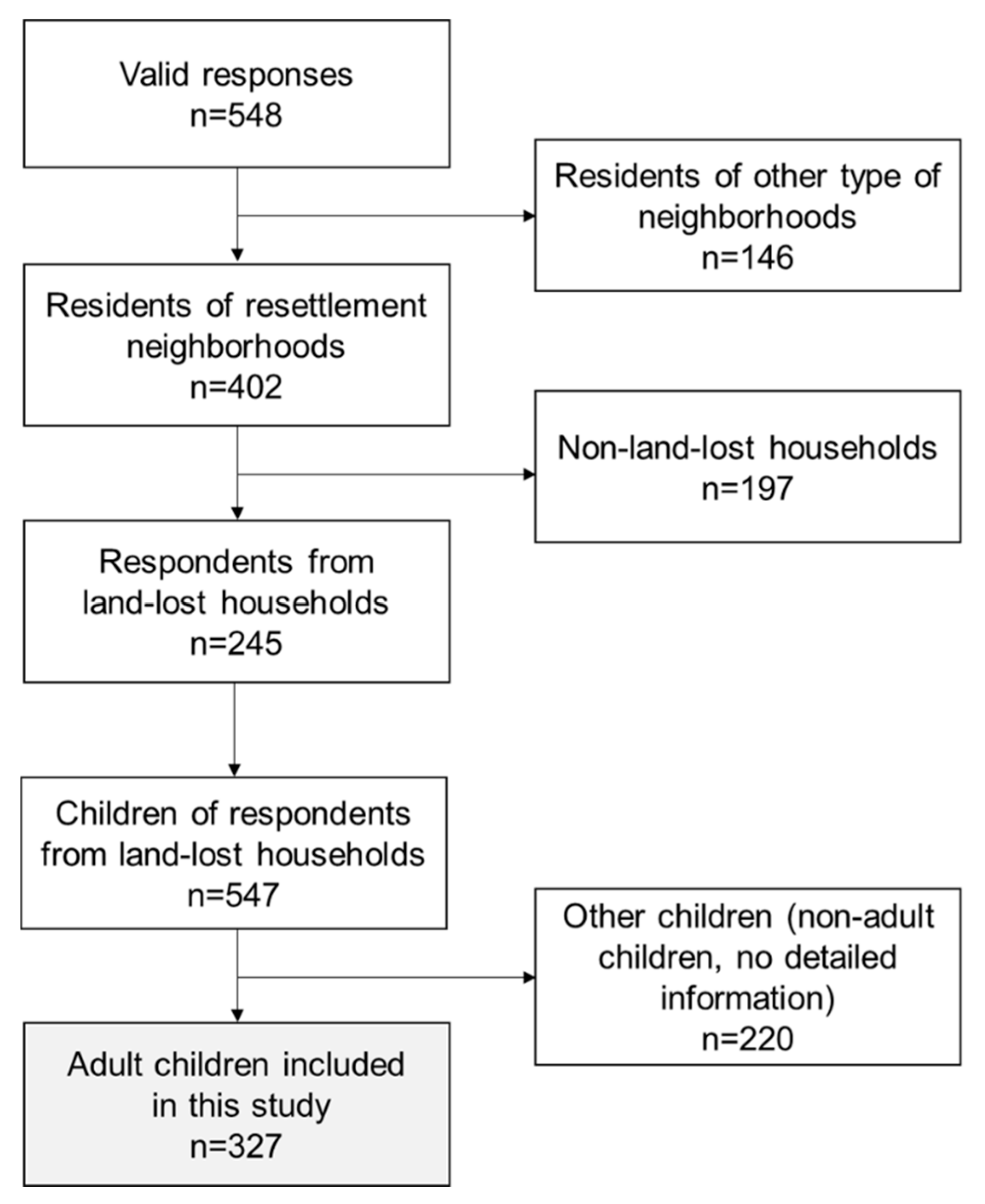
3.2. Data Collection
3.3. Measures
3.4. Analysis
4. Results
4.1. Sample Description
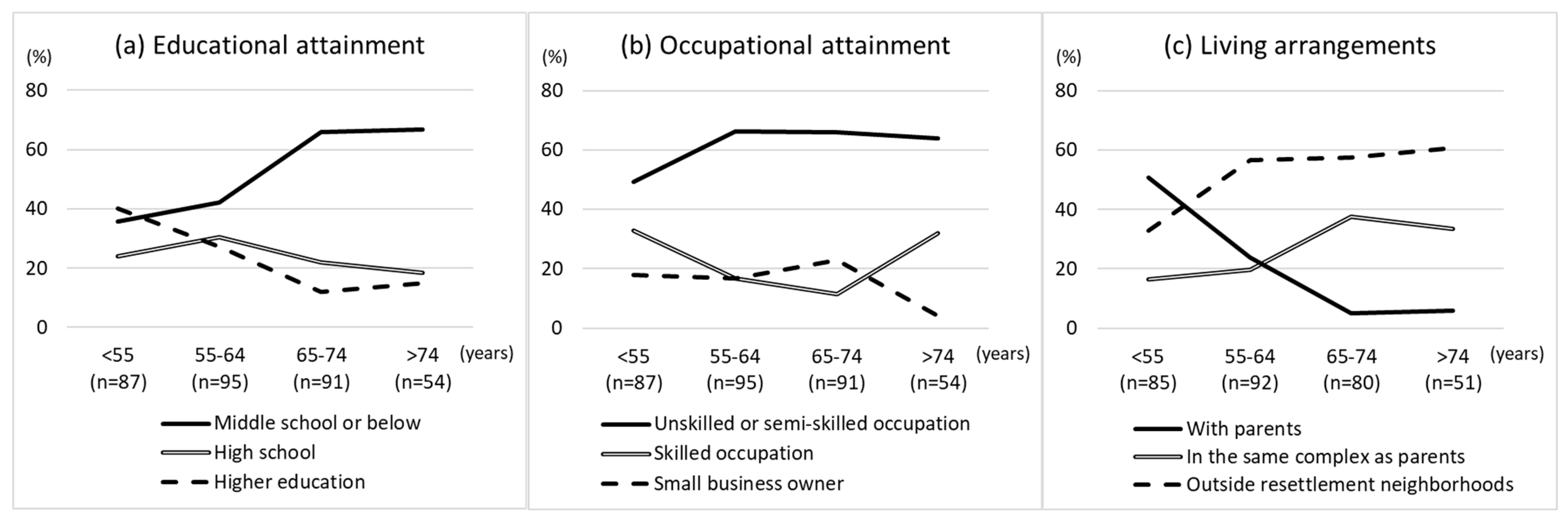
4.2. Descriptive Results
4.3. Multivariable Logistic Regression
5. Discussion
5.1. Economic Integration of Land-Lost Households
5.2. Spatial Integration of Land-Lost Farmers
6. Conclusions
Funding
Institutional Review Board Statement
Informed Consent Statement
Data Availability Statement
Acknowledgments
Conflicts of Interest
References
- National Bureau of Statistics of China. China Statistical Yearbook 2020; China Statistics Press: Beijing, China, 2020.
- Shi, K.; Chen, Y.; Yu, B.; Xu, T.; Li, L.; Huang, C.; Liu, R.; Chen, Z.; Wu, J. Urban expansion and agricultural land loss in China: A multiscale perspective. Sustainability 2016, 8, 790. [Google Scholar] [CrossRef] [Green Version]
- Lin, G.C.S. Reproducing spaces of Chinese urbanisation: New city-based and land-centred urban transformation. Urban Stud. 2007, 44, 1827–1855. [Google Scholar] [CrossRef]
- Hui, E.C.M.; Bao, H.J.; Zhang, X.L. The policy and praxis of compensation for land expropriations in China: An appraisal from the perspective of social exclusion. Land Use Policy 2013, 32, 309–316. [Google Scholar] [CrossRef]
- Hao, L.; Hu, A.; Lo, J. Two aspects of the rural-urban divide and educational stratification in China: A trajectory analysis. Comp. Educ. Rev. 2014, 58, 509–536. [Google Scholar] [CrossRef] [Green Version]
- Fu, T.M. Unequal primary education opportunities in rural and urban China. China Perspect. 2005, 60, 1–10. [Google Scholar] [CrossRef] [Green Version]
- Jiang, Y.; Waley, P.; Gonzalez, S. ‘Nice apartments, no jobs’: How former villagers experienced displacement and resettlement in the western suburbs of Shanghai. Urban Stud. 2018, 55, 3202–3217. [Google Scholar] [CrossRef]
- He, S.; Liu, Y.; Webster, C.; Wu, F. Property rights redistribution, entitlement failure and the impoverishment of landless farmers in China. Urban Stud. 2009, 46, 1925–1949. [Google Scholar] [CrossRef]
- Ong, L.H. State-led urbanization in China: Skyscrapers, land revenue and “concentrated villages”. China Q. 2014, 217, 162–179. [Google Scholar] [CrossRef]
- Du, H.; Song, J.; Li, S. ‘Peasants are peasants’: Prejudice against displaced villagers in newly-built urban neighbourhoods in China. Urban Stud. 2021, 58, 1598–1614. [Google Scholar] [CrossRef]
- Zhang, M.; Qiao, S.; Yeh, A.G.-O. Disamenity effects of displaced villagers’ resettlement community on housing price in China and implication for socio-spatial segregation. Appl. Geogr. 2022, 142, 102681. [Google Scholar] [CrossRef]
- Portes, A.; Rumbaut, R.G. Legacies: The Story of the Immigrant Second Generation; University of California Press: New York, NY, USA, 2001. [Google Scholar]
- Briggs, X.d.S. Brown kids in white suburbs: Housing mobility and the many faces of social capital. Hous. Policy Debate 1998, 9, 177–221. [Google Scholar] [CrossRef]
- Putnam, R.D. Bowling Alone: The Collapse and Revival of American Community; Simon & Schuster: New York, NY, USA, 2000. [Google Scholar]
- Massey, D.S.; Denton, N.A. Spatial assimilation as a socioeconomic outcome. Am. Sociol. Rev. 1985, 50, 94. [Google Scholar] [CrossRef]
- Massey, D.S. Ethnic residential segregation: A theoretical synthesis and empirical review. Sociol. Soc. Res. 1985, 69, 315–350. [Google Scholar]
- Logan, J.R.; Zhang, W.; Alba, R.D. Immigrant enclaves and ethnic communities in New York and Los Angeles. Am. Sociol. Rev. 2002, 67, 299. [Google Scholar] [CrossRef]
- Portes, A.; Zhou, M. The new second generation: Segmented assimilation and its variants. Ann. Am. Acad. Political Soc. Sci. 1993, 530, 74–96. [Google Scholar] [CrossRef]
- Ager, A.; Strang, A. Understanding integration: A conceptual framework. J. Refug. Stud. 2008, 21, 166–191. [Google Scholar] [CrossRef] [Green Version]
- Harder, N.; Figueroa, L.; Gillum, R.M.; Hangartner, D.; Laitin, D.D.; Hainmueller, J. Multidimensional measure of immigrant integration. Proc. Natl. Acad. Sci. USA 2018, 115, 201808793. [Google Scholar] [CrossRef] [Green Version]
- Chen, M. Analysis on land-lost rural aging labors’ integration into city in the course of urbanization. In Advances in Education and Management. ISAEBD 2011. Communications in Computer and Information Science; Zhou, M., Ed.; Springer: Berlin/Heidelberg, Germany, 2011; Volume 211, pp. 281–286. [Google Scholar] [CrossRef]
- Wang, W.W.; Fan, C.C. Migrant workers’ integration in urban China: Experiences in employment, social adaptation, and self-identity. Eurasian Geogr. Econ. 2012, 53, 731–749. [Google Scholar] [CrossRef]
- Liu, L.; Huang, Y.; Zhang, W. Residential segregation and perceptions of social integration in Shanghai, China. Urban Stud. 2017, 55, 1484–1503. [Google Scholar] [CrossRef]
- Tang, J.; Xu, Y.; Qiu, H. Integration of migrants in poverty alleviation resettlement to urban China. Cities 2022, 120, 103501. [Google Scholar] [CrossRef]
- Lin, S.; Wu, F.; Li, Z. Social integration of migrants across Chinese neighbourhoods. Geoforum 2020, 112, 118–128. [Google Scholar] [CrossRef]
- Neidert, L.J.; Farley, R. Assimilation in the United States: An analysis of ethnic and generation differences in status and achievement. Am. Sociol. Rev. 1985, 50, 840. [Google Scholar] [CrossRef]
- Arias, E. Change in nuptiality patterns among Cuban Americans-Evidence of cultural and structural assimilation. Int. Migr. Rev. 2001, 35, 525–556. [Google Scholar] [CrossRef]
- Yang, G.; Zhou, C.; Jin, W. Integration of migrant workers: Differentiation among three rural migrant enclaves in Shenzhen. Cities 2020, 96, 102453. [Google Scholar] [CrossRef]
- Gordon, M. Assimilation in American Life: The Role of Race, Religion and National Origins; Oxford University Press: Oxford, UK, 1964; ISBN 0195008960. [Google Scholar]
- Haller, W.; Portes, A.; Lynch, S.M. Dreams fulfilled, dreams shattered-Determinants of segmented assimilation in the second generation. Soc. Forces 2011, 89, 733–762. [Google Scholar] [CrossRef] [Green Version]
- Zhou, M. Growing up American: The challenge confronting immigrant children and children of immigrants. Annu. Rev. Sociol. 1997, 23, 63–95. [Google Scholar] [CrossRef]
- Zhou, M. Segmented assimilation: Issues, controversies, and recent research on the new second generation1. Int. Migr. Rev. 1997, 31, 975–1008. [Google Scholar] [CrossRef] [Green Version]
- Massey, D.S. New Faces in New Places: The Changing Geography of American Immigration; Russell Sage Foundation: New York, NY, USA, 2008; ISBN 1610443810. [Google Scholar]
- Chen, Y.; Wang, J. Social integration of new-generation migrants in Shanghai China. Habitat Int. 2015, 49, 419–425. [Google Scholar] [CrossRef]
- Wang, M.; Ning, Y. The social integration of migrants in Shanghai’s urban villages. China Rev. 2016, 16, 93–120. [Google Scholar]
- Liu, J.; Dai, H.; Li, M.; Li, M.S. Personal networks and employment: A study on landless farmers in Yunnan province of China. Asia Pac. J. Soc. Work 2017, 28, 71–83. [Google Scholar] [CrossRef]
- Karmakar, P. Politics of development: Land acquisition and economic development in India. J. Land Rural Stud. 2017, 5, 164–182. [Google Scholar] [CrossRef]
- Tuan, N.T.; Hegedűs, G. Urbanization and post-acquisition livelihood in a peri-urban context in Vietnam: A geographical comparison between Hanoi, Danang, and Vinh City. Land 2022, 11, 1787. [Google Scholar] [CrossRef]
- Li, C.; Wang, M.; Song, Y. Vulnerability and livelihood restoration of landless households after land acquisition: Evidence from peri-urban China. Habitat Int. 2018, 79, 109–115. [Google Scholar] [CrossRef]
- Huang, X.; Huang, X.; He, Y.; Yang, X. Assessment of livelihood vulnerability of land-lost farmers in urban fringes: A case study of Xi’an, China. Habitat Int. 2017, 59, 1–9. [Google Scholar] [CrossRef]
- Lai, Y.; Peng, Y.; Li, B.; Lin, Y. Industrial land development in urban villages in China: A property rights perspective. Habitat Int. 2014, 41, 185–194. [Google Scholar] [CrossRef] [Green Version]
- Tong, D.; Wang, X.; Wu, L.; Zhao, N. Land ownership and the likelihood of land development at the urban fringe: The case of Shenzhen, China. Habitat Int. 2018, 73, 43–52. [Google Scholar] [CrossRef]
- Lin, G.C.; Zhang, A.Y. Emerging spaces of neoliberal urbanism in China: Land commodification, municipal finance and local economic growth in prefecture-level cities. Urban Stud. 2015, 52, 2774–2798. [Google Scholar] [CrossRef]
- Qian, Z. Land acquisition compensation in post-reform China: Evolution, structure and challenges in Hangzhou. Land Use Policy 2015, 46, 250–257. [Google Scholar] [CrossRef]
- Zhao, W.; Zou, Y. Un-gating the gated community: The spatial restructuring of a resettlement neighborhood in Nanjing. Cities 2017, 62, 78–87. [Google Scholar] [CrossRef]
- Liang, Y.; Li, S. Landless female peasants living in resettlement residential areas in China have poorer quality of life than males: Results from a household study in the Yangtze River Delta region. Health Qual. Life Outcomes 2014, 12, 71. [Google Scholar] [CrossRef] [Green Version]
- Tong, W.; Zhang, P.; Lo, K.; Chen, T.; Gao, R. Age-differentiated impact of land appropriation and resettlement on landless farmers: A case study of Xinghua village, China. Geogr. Res. 2017, 55, 293–304. [Google Scholar] [CrossRef]
- Xie, Y. Land expropriation, shock to employment, and employment differentiation: Findings from land-lost farmers in Nanjing, China. Land Use Policy 2019, 87, 104040. [Google Scholar] [CrossRef]
- Song, J.; Du, H.; Li, S. Who is the winner? Relocated rural communities and stratification in urbanizing northwestern China. J. Rural Stud. 2020, 77, 159–168. [Google Scholar] [CrossRef]
- Wang, H.; Cheng, P.; Liang, P.; Liu, K.; Nie, X. Invisible windfalls and wipeouts: What is the impact of spatial regulation on the welfare of land-lost farmers? Habitat Int. 2020, 99, 102159. [Google Scholar] [CrossRef]
- Zhan, S. Accumulation by and without Dispossession: Rural Land Use, Land Expropriation, and Livelihood Implications in China. J. Agrar. Chang. 2019, 19, 447–464. [Google Scholar] [CrossRef]
- Yin, G.; Liu, Y.; Wang, F. Emerging Chinese New Towns: Local Government-Directed Capital Switching in Inland China. Cities 2018, 79, 102–112. [Google Scholar] [CrossRef]
- Chen, C.; Wu, Y. Impact of Foreign Direct Investment and Export on Urbanization: Evidence from China. China World Econ. 2017, 25, 71–89. [Google Scholar] [CrossRef]
- Chung, H.; Unger, J. The Guangdong model of urbanisation: Collective village land and the making of a new middle class. China Perspect. 2013, 2013, 33–41. [Google Scholar] [CrossRef] [Green Version]
- Wang, H.; Zhu, P.; Chen, X.; Swider, S. Land Expropriation in Urbanizing China: An Examination of Negotiations and Compensation. Urban Geogr. 2017, 38, 401–419. [Google Scholar] [CrossRef] [Green Version]
- Wang, M.; Krstikj, A.; Koura, H. Effects of Urban Planning on Urban Expansion Control in Yinchuan City, Western China. Habitat Int. 2017, 64, 85–97. [Google Scholar] [CrossRef]
- Lv, T.; Wang, L.; Zhang, X.; Xie, H.; Lu, H.; Li, H.; Liu, W.; Zhang, Y. Coupling coordinated development and exploring its influencing factors in Nanchang, China: From the perspectives of land urbanization and population urbanization. Land 2019, 8, 178. [Google Scholar] [CrossRef]
- Lian, H.; Glendinning, A.; Yin, B. The issue of ‘land-lost’ farmers in the People’s Republic of China: Reasons for discontent, actions and claims to legitimacy. J. Contemp. China 2016, 25, 718–730. [Google Scholar] [CrossRef]
- Chen, J.; Chen, S.; Landry, P.F.; Davis, D.S. How dynamics of urbanization affect physical and mental health in urban China. China Q. 2014, 220, 988–1011. [Google Scholar] [CrossRef]
- Statistics Bureau of Nanchang. Nangchang Statistical Yearbook 2021; China Statistical Press: Beijing, China, 2022.
- Office of the Leading Group of the State Council for the Seventh National Population Census. Tabulation on 2020 China Population Census by Country; China Statistics Press: Beijing, China, 2022.
- Zheng, Y.; Zhang, X.; Zhu, Y. Overeducation, major mismatch, and return to higher education tiers: Evidence from novel data source of a major online recruitment platform in China. China Econ. Rev. 2021, 66, 101584. [Google Scholar] [CrossRef]
- Luo, Y.; Guo, F.; Shi, J. Expansion and inequality of higher education in China: How likely would Chinese poor students get to success? High. Educ. Res. Dev. 2018, 37, 1015–1034. [Google Scholar] [CrossRef]
- Yeung, W.-J.J. Higher education expansion and social stratification in China. Chin. Sociol. Rev. 2013, 45, 54–80. [Google Scholar] [CrossRef]


| n | % | |
|---|---|---|
| Sex | ||
| Male | 108 | 44.1 |
| Female | 136 | 55.5 |
| No answer | 1 | 0.4 |
| Age (years) | ||
| 18–29 | 26 | 10.6 |
| 30–39 | 52 | 21.2 |
| 40–49 | 39 | 15.9 |
| 50–59 | 62 | 25.3 |
| 60 or more | 66 | 26.9 |
| Marital status | ||
| Single | 23 | 9.4 |
| Married | 209 | 85.3 |
| Divorced/widowed | 13 | 5.3 |
| Location of resettlement housing | ||
| Fenghuang area | 71 | 29.0 |
| Central area | 59 | 24.1 |
| Hongjiaozhou area | 53 | 21.6 |
| Jiulonghu area | 62 | 25.3 |
| Number of children | ||
| None | 20 | 8.2 |
| 1 | 35 | 14.3 |
| 2 | 87 | 35.5 |
| 3 | 57 | 23.3 |
| 4 | 18 | 7.3 |
| 5 or more | 18 | 7.3 |
| No answer | 10 | 4.1 |
| Total (n = 327) | Generation of Offspring | Spatial Integration | ||||||
|---|---|---|---|---|---|---|---|---|
| Younger (n = 136) | Older (n = 191) | p | Lower (n = 151) | Higher (n = 157) | p | |||
| n/Mean | %/SD | %/Mean | %/Mean | %/Mean | %/Mean | |||
| Sex | n.s. | <0.001 | ||||||
| Male | 187 | 57.2 | 61.8 | 53.9 | 76.2 | 39.5 | ||
| Female | 140 | 42.8 | 38.2 | 46.1 | 23.8 | 60.5 | ||
| Generation | 0.005 | |||||||
| Younger generation offspring | 136 | 41.6 | - | - | 51.7 | 35.7 | ||
| Older generation offspring | 191 | 58.4 | - | - | 48.3 | 64.3 | ||
| Location of parents’ residence | n.s. | <0.001 | ||||||
| Fenghuang area | 90 | 27.5 | 25.0 | 29.3 | 36.4 | 18.5 | ||
| Central area | 97 | 29.7 | 32.4 | 27.8 | 30.5 | 30.6 | ||
| Hongjiaozhou area | 62 | 19.0 | 23.5 | 15.7 | 12.6 | 25.5 | ||
| Jiulonghu area | 78 | 23.9 | 19.1 | 27.2 | 20.5 | 25.5 | ||
| Educational attainment | <0.001 | n.s. | ||||||
| Middle school or below | 167 | 51.1 | 39.7 | 59.2 | 48.3 | 53.5 | ||
| High school | 80 | 24.5 | 26.5 | 23.0 | 27.8 | 21.0 | ||
| Higher education | 80 | 24.5 | 33.8 | 17.8 | 23.8 | 25.5 | ||
| Occupational attainment | n.s. | 0.013 | ||||||
| Agricultural and manual workers | 124 | 37.9 | 33.1 | 41.4 | 43.1 | 33.8 | ||
| Service and sales workers | 51 | 15.6 | 14.7 | 16.2 | 19.2 | 12.1 | ||
| Professionals/office clerks/managers | 63 | 19.3 | 24.3 | 15.7 | 14.6 | 24.2 | ||
| Small business owners | 47 | 14.4 | 12.5 | 15.7 | 15.2 | 13.4 | ||
| Not working/don’t know/no answer | 42 | 12.8 | 15.4 | 11.0 | 8.0 | 16.6 | ||
| Living arrangements | <0.001 | |||||||
| Living with parents | 72 | 22.0 | 41.2 | 8.4 | - | - | ||
| Living in the same complex as parents | 79 | 24.2 | 16.2 | 29.8 | - | - | ||
| Living in other areas in the new district | 52 | 15.9 | 11.8 | 18.9 | - | - | ||
| Living in other areas in Nanchang | 85 | 26.0 | 23.5 | 27.8 | - | - | ||
| Living outside Nanchang | 20 | 6.1 | 5.9 | 6.3 | - | - | ||
| No answer | 19 | 5.8 | 1.5 | 8.9 | - | - | ||
| Number of siblings | 3.3 | 1.3 | 2.7 | 3.8 | <0.001 | 2.9 | 3.7 | <0.001 |
| Number of houses owned | 2.4 | 1.5 | 2.4 | 2.3 | n.s. | 2.4 | 2.4 | n.s. |
| Model 1 | Model 2 | |||||||
|---|---|---|---|---|---|---|---|---|
| OR | 95 CIs | OR | 95 CIs | |||||
| Sex | ||||||||
| Male | 1.00 (reference) | 1.00 (reference) | ||||||
| Female | 4.86 | *** | 2.73 | 8.63 | 4.99 | *** | 2.71 | 9.18 |
| Generation | ||||||||
| Younger generation offspring | 1.00 (reference) | 1.00 (reference) | ||||||
| Older generation offspring | 1.88 | * | 1.03 | 3.44 | 2.07 | * | 1.09 | 3.91 |
| Location of parents’ residence | ||||||||
| Fenghuang area | 0.38 | ** | 0.19 | 0.78 | 0.30 | ** | 0.14 | 0.66 |
| Central area | 1.00 (reference) | 1.00 (reference) | ||||||
| Hongjiaozhou area | 1.54 | 0.68 | 3.48 | 1.35 | 0.57 | 3.18 | ||
| Jiulonghu area | 1.00 | 0.47 | 2.13 | 0.87 | 0.39 | 1.91 | ||
| Number of siblings | 1.41 | * | 1.08 | 1.83 | 1.51 | ** | 1.14 | 2.00 |
| Number of houses owned | 0.86 | 0.72 | 1.03 | 0.80 | * | 0.66 | 0.97 | |
| Educational attainment | ||||||||
| Middle school or below | 0.36 | ** | 0.18 | 0.73 | 0.67 | 0.30 | 1.47 | |
| High school | 0.44 | * | 0.20 | 0.96 | 0.64 | 0.27 | 1.50 | |
| Higher education | 1.00 (reference) | 1.00 (reference) | ||||||
| Occupational attainment | ||||||||
| Agricultural and manual workers | 0.17 | *** | 0.07 | 0.45 | ||||
| Service and sales workers | 0.17 | ** | 0.06 | 0.46 | ||||
| Professionals/office clerks/managers | 1.00 (reference) | |||||||
| Small business owners | 0.25 | ** | 0.09 | 0.70 | ||||
| Not working/don’t know/no answer | 0.51 | 0.17 | 1.53 | |||||
| Constant | 0.09 | *** | 0.03 | 0.25 | 0.20 | ** | 0.06 | 0.61 |
| n | 296 | 296 | ||||||
| McFadden’s R2 | 0.192 | 0.239 | ||||||
| Younger Generation Offspring | ||||||||
|---|---|---|---|---|---|---|---|---|
| Model 3 | Model 4 | |||||||
| OR | 95 CIs | OR | 95 CIs | |||||
| Sex | ||||||||
| Male | 1.00 (reference) | 1.00 (reference) | ||||||
| Female | 9.51 | *** | 3.74 | 24.16 | 8.32 | *** | 3.07 | 22.52 |
| Location of parents’ residence | ||||||||
| Fenghuang area | 0.85 | 0.26 | 2.78 | 0.76 | 0.22 | 2.66 | ||
| Central area | 1.00 (reference) | 1.00 (reference) | ||||||
| Hongjiaozhou area | 0.63 | 0.17 | 2.38 | 0.68 | 0.17 | 2.72 | ||
| Jiulonghu area | 2.64 | 0.77 | 9.02 | 2.19 | 0.56 | 8.52 | ||
| Number of siblings | 1.46 | 0.82 | 2.60 | 1.56 | 0.82 | 2.97 | ||
| Number of houses owned | 0.78 | 0.60 | 1.03 | 0.81 | 0.61 | 1.09 | ||
| Educational attainment | ||||||||
| Middle school or below | 0.88 | 0.31 | 2.51 | 2.42 | 0.63 | 9.22 | ||
| High school | 1.04 | 0.34 | 3.18 | 1.85 | 0.52 | 6.67 | ||
| Higher education | 1.00 (reference) | 1.00 (reference) | ||||||
| Occupational attainment | ||||||||
| Agricultural and manual workers | 0.15 | * | 0.03 | 0.69 | ||||
| Service and sales workers | 0.18 | * | 0.04 | 0.90 | ||||
| Professionals/office clerks/managers | 1.00 (reference) | |||||||
| Small business owners | 0.14 | * | 0.02 | 0.81 | ||||
| Not working/don’t know/no answer | 1.11 | 0.22 | 5.71 | |||||
| Constant | 0.02 | *** | 0.00 | 0.11 | 0.03 | *** | 0.00 | 0.21 |
| n | 130 | 130 | ||||||
| McFadden’s R2 | 0.229 | 0.299 | ||||||
| Older generation offspring | ||||||||
| Model 5 | Model 6 | |||||||
| OR | 95 CIs | OR | 95 CIs | |||||
| Sex | ||||||||
| Male | 1.00 (reference) | 1.00 (reference) | ||||||
| Female | 4.38 | *** | 1.94 | 9.91 | 5.63 | *** | 2.30 | 13.80 |
| Location of parents’ residence | ||||||||
| Fenghuang area | 0.21 | ** | 0.08 | 0.58 | 0.17 | ** | 0.06 | 0.52 |
| Central area | 1.00 (reference) | 1.00 (reference) | ||||||
| Hongjiaozhou area | 3.74 | 0.86 | 16.20 | 2.82 | 0.60 | 13.35 | ||
| Jiulonghu area | 0.48 | 0.16 | 1.39 | 0.44 | 0.14 | 1.38 | ||
| Number of siblings | 1.57 | ** | 1.12 | 2.19 | 1.58 | * | 1.10 | 2.25 |
| Number of houses owned | 0.77 | 0.58 | 1.03 | 0.67 | * | 0.49 | 0.93 | |
| Educational attainment | ||||||||
| Middle school or below | 0.14 | ** | 0.04 | 0.46 | 0.19 | * | 0.05 | 0.69 |
| High school | 0.12 | ** | 0.03 | 0.45 | 0.14 | ** | 0.03 | 0.60 |
| Higher education | 1.00 (reference) | 1.00 (reference) | ||||||
| Occupational attainment | ||||||||
| Agricultural and manual workers | 0.13 | * | 0.03 | 0.68 | ||||
| Service and sales workers | 0.09 | ** | 0.02 | 0.49 | ||||
| Professionals/office clerks/managers | 1.00 (reference) | |||||||
| Small business owners | 0.22 | 0.04 | 1.26 | |||||
| Not working/don’t know/no answer | 0.21 | 0.03 | 1.37 | |||||
| Constant | 0.54 | 0.10 | 2.77 | 2.59 | 0.33 | 20.38 | ||
| n | 166 | 166 | ||||||
| McFadden’s R2 | 0.250 | 0.293 | ||||||
Disclaimer/Publisher’s Note: The statements, opinions and data contained in all publications are solely those of the individual author(s) and contributor(s) and not of MDPI and/or the editor(s). MDPI and/or the editor(s) disclaim responsibility for any injury to people or property resulting from any ideas, methods, instructions or products referred to in the content. |
© 2022 by the author. Licensee MDPI, Basel, Switzerland. This article is an open access article distributed under the terms and conditions of the Creative Commons Attribution (CC BY) license (https://creativecommons.org/licenses/by/4.0/).
Share and Cite
Teng, Y. Economic and Spatial Integration of Land-Lost Households in Inland China: Evidence from a Survey in Nanchang City. Sustainability 2023, 15, 558. https://doi.org/10.3390/su15010558
Teng Y. Economic and Spatial Integration of Land-Lost Households in Inland China: Evidence from a Survey in Nanchang City. Sustainability. 2023; 15(1):558. https://doi.org/10.3390/su15010558
Chicago/Turabian StyleTeng, Yuanyuan. 2023. "Economic and Spatial Integration of Land-Lost Households in Inland China: Evidence from a Survey in Nanchang City" Sustainability 15, no. 1: 558. https://doi.org/10.3390/su15010558