Article

Simulation of Freshwater Ecosystem Service Flows under Land-Use Change: A Case Study of Lianshui River Basin, China

School of Geographical Sciences, Hunan Normal University, Changsha 410081, China
*
Author to whom correspondence should be addressed.
Sustainability 2022, 14(6), 3270; https://doi.org/10.3390/su14063270
Submission received: 24 January 2022 / Revised: 24 February 2022 / Accepted: 7 March 2022 / Published: 10 March 2022
(This article belongs to the Topic Water Management in the Era of Climatic Change)

Abstract

:
The service function of freshwater ecosystem is of great significance for ensuring the water security and the sustainable development of the social economy. However, it is vague how land-use change can influence freshwater ecosystem service flows. In this paper, we analyzed the land-use changes in the Lianshui River Basin from 2000 to 2018, built an ecosystem service flow model, and quantified the supply, demand, and flow of freshwater ecosystems under land-use change. The most intensified shifts of land-use change were the transfer of woodland to arable land and the transfer of arable land to built-up land. Urbanization and deforestation have increased water output by 0.06 billion m3, but water demand has increased by 2.42 billion m3, resulting in a 6% reduction in the flow of freshwater ecosystem services. Our study provides detailed information on freshwater ecosystem services flow from providers to beneficiaries within a watershed, showing how land-use change and ecosystem service flows can be integrated at the watershed scale to provide information for land-use management and the availability of freshwater ecosystems. Sustained development provides a scientific basis.

1. Introduction

Life originates from water, and water is also an important component of all living things, and its importance is self-evident. Freshwater supply is closely related to human well-being and is one of the most important ecosystem services [1]. Aquatic ecosystems were the main providers of ecosystem services, especially in the area south of the Yangtze River [2]. Freshwater ecosystem services have great constraints on the sustainable development of many river basins in the south. With the rapid economic development and intensification of land-use, excessive resource development has caused serious damage to the environment. The research on ecosystem services has become a hot spot and frontier, which is of great significance to regional ecology and sustainable development [3,4].
Land-use is one of the most important factors affecting ecosystem services [5,6]. Land-use affects ecosystem services with its type, pattern, and intensity changes [7]. Scientific assessment in the impact of regional land-use changes on the water production function of ecosystems is of great significance to the use of regional water resources [8,9,10,11]. The large-scale urban construction activities or conversion of cropland to forest will lead to the change of the underlying surface of the basin, which affects the infiltration process and sink flow process of vegetation evaporation and precipitation entering the soil aquifer and then affects the hydrological cycle interaction process of the whole basin [12,13]. In addition, land-use may also have an impact on the annual runoff, dry season runoff, and flood peak discharge in the basin, which are mainly reflected in the change of water resources in the water cycle and the change of spatial and temporal distribution pattern, which will lead to significant changes in the relationship between water supply and demand in different regions, thus indirectly affecting water ecosystem services [14,15]. Many studies have analyzed the impact of land-use changes on freshwater ecosystem supply, but few studies have conducted quantitative analysis on the flow of freshwater ecosystem services under land-use changes [16,17].
Land-use changes such as urban sprawl increase the supply of freshwater but also greatly increase the demand for it, which poses new challenges for freshwater resource management [18]. Several attempts have been made to map the spatial dynamics of freshwater ecosystem service supply/demand [19,20,21,22]. However, its assessment often has a mismatch between supply and delivery to beneficiaries. Existing studies on quantifying the impact of land-use of ecosystem service flows mostly achieve their goals by scoring land-use cover types or mapping services and benefit areas at the landscape scale [23,24,25], without knowing the specific information of freshwater ecosystem service flows.
Introducing the flow characteristics of water resources into the evaluation of freshwater ecosystem services can comprehensively analyze the supply, flow path, and demand response mechanism of freshwater ecosystem services to land-use changes, while avoiding the spatial mismatch between supply and demand areas of ecosystem services [26]. The research of ecosystem service flow usually adopts the model method; the Integrated Valuation of Ecosystem Services and Tradeoffs (InVEST) model is applied to quantify the supply of ecosystem service, and the digital elevation model (DEM) can be used to determine the direction of water flow, coupled with the Service Path Attribute Networks (SPANs) model, in which artificial intelligence captures the spatial relationship of ecosystem service flow [17].
The objectives of this study were to map land-use pattern changes, construct a spatial flow model for ecosystem services, and quantify the impact of land-use changes on freshwater ecosystem service flows. For the aim of this study, we used the InVEST model to quantify the supply of freshwater ecosystem services, calculated the water demand of various industries, and combined the SPANs model to construct a spatial watershed model for ecosystem services, quantifying the impact of land-use change in the study area from 2000 to 2018. Impacts on supply, demand, and flow of freshwater ecosystem services. This study can provide a scientific basis for water resources management and ecological protection in the Lianshui River Basin and similar ecosystem basins.

2. Materials and Methods
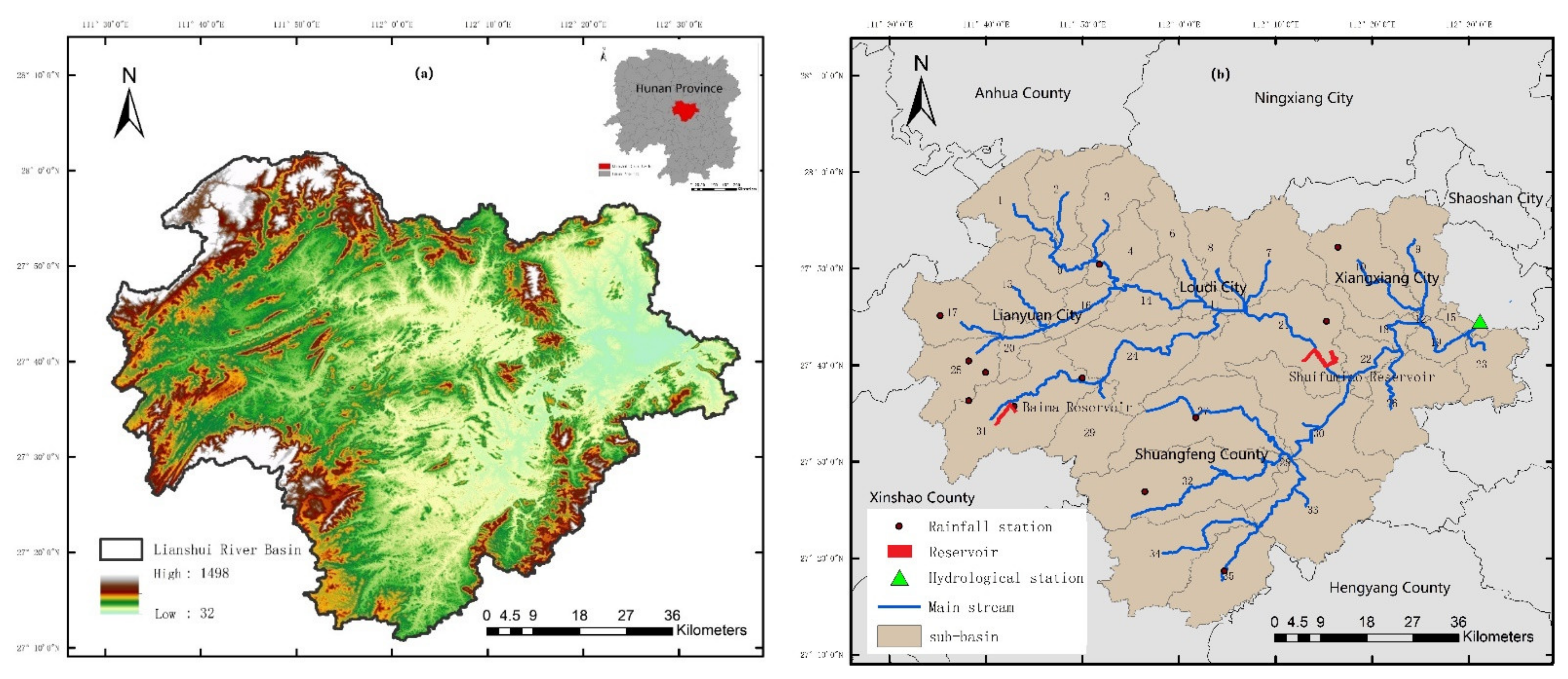
2.1. Study Area

The Lianshui River Basin is located in the central part of Hunan Province, China, and is a primary tributary on the left bank of the lower Xiangjiang River. The study area is above the Xiangxiang Hydrological station with a catchment area of 5919.03 km2, including 35 sub-basins, and is located between Shaoyang City, Loudi City, and Xiangtan City (Figure 1). The basin has an average annual temperature of 17.5~18.5 °C and average annual precipitation of 1368 mm. The Shuifumiao reservoir and Baima reservoir are the main sources of freshwater supply [27]. With the rapid economic development, urbanization has led to a series of problems such as water shortages and habitat destruction. Therefore, studying the freshwater ecosystem service flow is of utmost importance to local water security.

2.2. Data Sources

The digital elevation model (DEM) data were downloaded from the geospatial data cloud website with a resolution of 30 m. The land-use data in 2000 and 2018 were obtained from the Center for Resources and Environment of the Chinese Academy of Sciences with a resolution of 30 m. The soil data were provided by the Harmonized World Soil Database produced by the Food and Agriculture Organization of the United Nations (FAO), and processed by the Institute of Soil Science, Chinese Academy of Sciences. The daily data of five meteorological stations in the research area from 2000 to 2018 were obtained from China Meteorological Data. Due to the sparse distribution of meteorological stations, the Hunan Hydrological Bureau supplemented the daily rainfall data of nine rainfall stations and the continuous hydrological observation data of the Xiangxiang Hydrological Station. The statistical data came from the “Water Resources Bulletin” and the “Statistical Yearbook” (Table 1). All data were resampled to a resolution of 1 km by the Nearest Neighbor Method (NEAREST) in ArcGIS10.5 [28].

2.3. Analytical Methodology

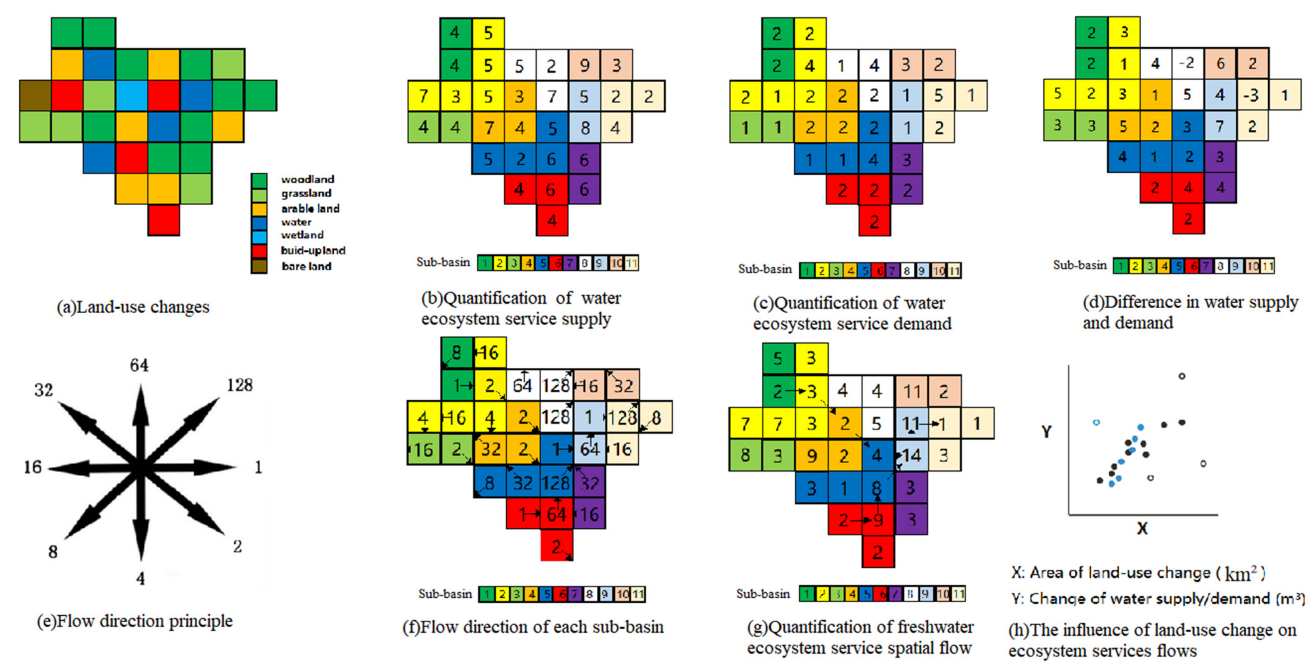
2.3.1. Land-Use Dynamic Change

The study basin and 35 sub-basins were divided through the processing of depression, flow direction, and flow with the Spatial Analyst in ArcGIS10.5 based on the DEM. Based on the National Current Land-use Standards (GB/T 21010-2017), land-use in the study area was classified into seven types including woodland, arable land, grassland, water, built-up land, wetland, bare land, and the Kappa coefficient was used to evaluate the results of reclassification [29].
The essence of the land-use transfer matrix is the Markov model [2,30], which can not only quantitatively indicate the conversion between different land-use types but also reveal the transfer rate between different land-use types, so it is widely used in the analysis of land-use changes. The transition matrix model is as follows:
A i j = A 11 A 12 A 1 n A 21 A 22 A 2 n A n 1 A n 2 A n n
where A i j represents the area of the land type i before the transfer is converted to the land type j after the transfer; n represents the total number of land-use types; i , j (i, j = 1, 2, …, n) is the land-use types before and after the transfer, respectively.

2.3.2. Quantification of Freshwater Ecosystem Service Supply

We used water supply, which is projected by the InVEST model to represent freshwater ES supply [1]. This model was jointly developed by Stanford University, the Nature Conservancy (TNC), and the World Wide Fund for Nature (WWF) [31]. The water production module was based on the water balance formula, ignoring the interactive flow between the surface and groundwater, and calculated the water production through parameters such as precipitation, plant transpiration, surface evaporation, root depth, and soil depth [21]. The main algorithm was as follows:
Y x j = 1 A E T x j P x · P x
where Y x j is the annual water production of the j-th land-use type in the grid x, mm; A E T x j is the actual annual evapotranspiration of the j-th land-use type in the grid x, mm; P x is the average annual precipitationthe in grid x, mm; A E T x j P x is an approximation of the Budyko curve estimated by [32] as follows:
A E T x j P x = 1 + ω x R x j 1 + ω x R x j + 1 R x j
ω x = Z · A W C x P x + 1.25
where ω x is an unrealistic parameter that describes the soil properties under natural climatic conditions; R x j is the aridity index of the j-th type of land-use type in the grid x, defined as the ratio of potential evaporation to precipitation; A W C x is the available water content of the vegetation the in grid x, mm, which is used to determine the amount of water provided by the soil for plant growth; Z is the Zhang coefficient, and the more rainfall in the study area, the greater the Zhang coefficient.
Precipitation is first averaged over many years, and then the multi-year average precipitation grid data is obtained through inverse distance-weighted interpolation. Based on daily meteorological data, the FAO-modified Penman–Monteith formula is used to calculate the potential evaporation, and the multi-year average potential evaporation raster data are obtained through the spatial interpolation method [33]. The soil depth data come from the World Soil Database constructed by the FAO. Based on the percentage content of the soil texture, the reference crop evapotranspiration is calculated in the SPAW software using the empirical formula of soil effective water content [34]. The root restricting layer depth can be replaced by approximate soil depth [35]. The operating parameters of the InVEST water yield model are shown in Table 2.

2.3.3. Quantification of Freshwater Ecosystem Service Demand

According to the definition of ecosystem service by the Millennium Ecosystem Assessment [36], we regarded actual water consumption as the demand for freshwater ecosystems, including agricultural water, industrial water, and domestic water (urban resident domestic water and rural resident domestic water). The formula was as follows:
W d e m = W a g r + W i n d + W d o m = C a g r · L a g r + C i n d · L i n d + C d o m u · L d o m u + C d o m r · L d o m r
where W a g r , W i n d , and W d o m are agricultural, industrial, and domestic demand for water, respectively. C a g r represents water requirement per unit quality of crop products, L a g r represents crop yield, C i n d is the water indicator per 10,000 yuan of the GDP, L i n d is the GDP, C d o m u stands for the domestic water quota of urban residents, L d o m u stands the number of urban residents, C d o m r is dthe omestic water quota for rural residents, and L d o m r is the number of rural residents. Table 3 shows details for these indices of water demand in the study area.

2.3.4. Quantification of Freshwater Ecosystem Service Spatial Flow

Following [37], we defined the freshwater ecosystem flow as the water flowing downstream after the water resources meet the upstream demand by the SPANs [38]. Given the difficulty of obtaining groundwater data, we only consider surface water in the model. The spatial relationship was identified as the path and direction of water flow, which were tracked in ArcGIS10.5 based on the DEM and river water system data. Figure 2 showed the schematic diagram of freshwater ecosystem service flow under land-use change.

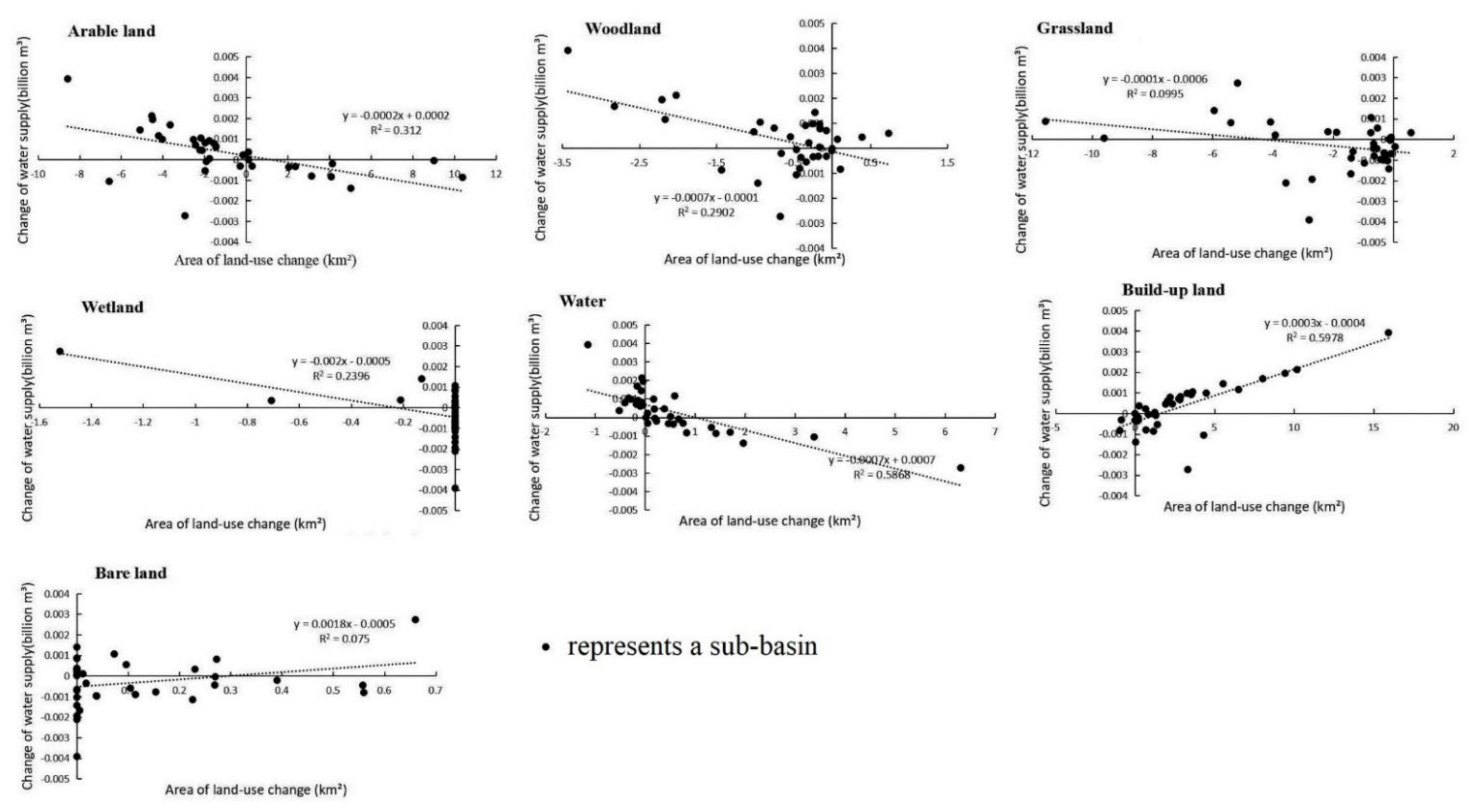
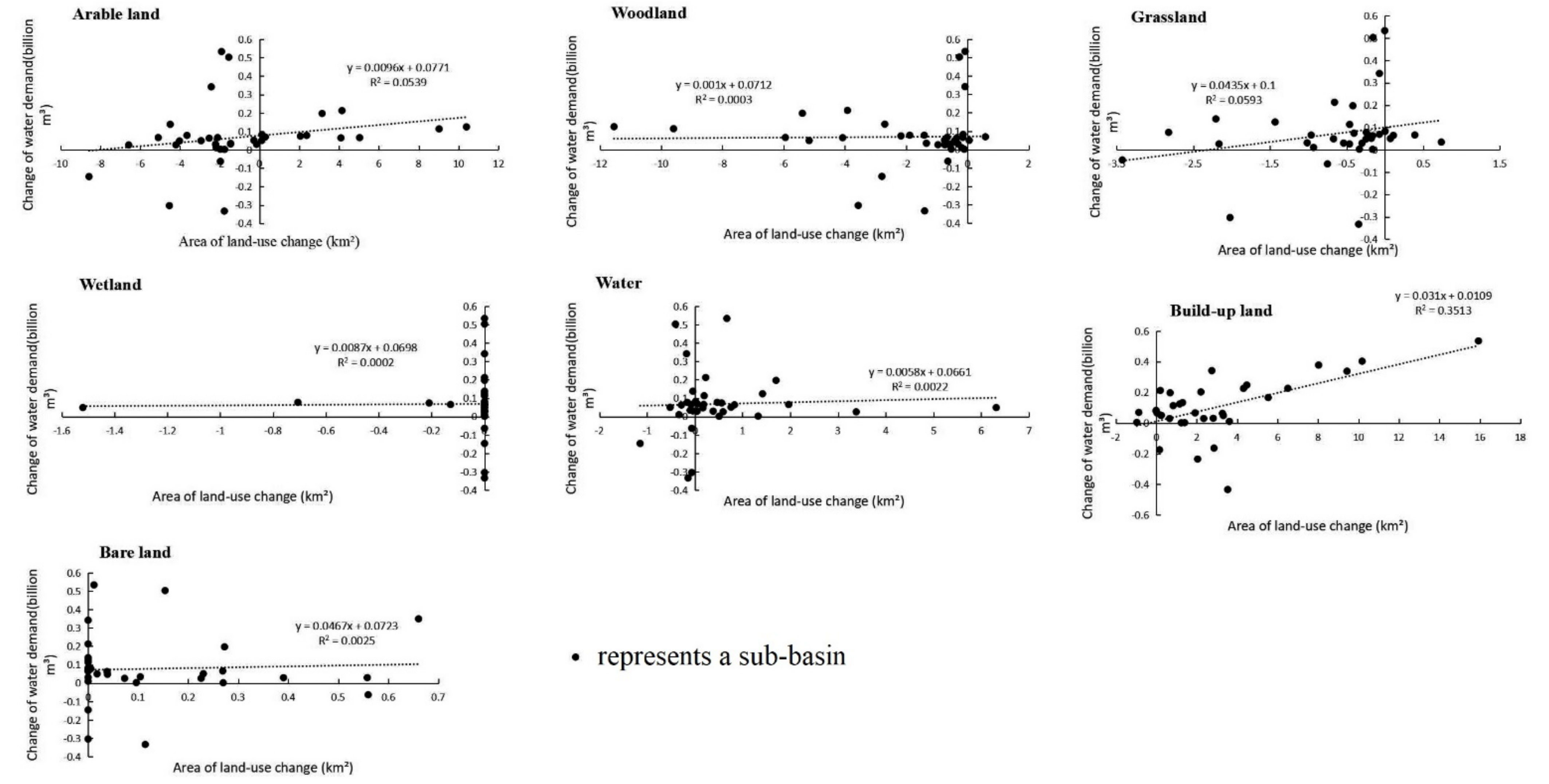
2.3.5. Calculation of the Influence of Land-Use Change on Ecosystem Services Flows

We obtained the land-use change matrix during the study period from the 2000–2018 land-use map. In the calculation of the InVEST water supply module, the climatic conditions were fixed and only the land-use data set was changed. Additionally, the slope of the trend line of water supply/demand and land-use area change was used to characterize the response of water supply/demand to land-use change.

3. Results

3.1. Land-Use Change

The Google Earth Quick Bird decimeter-level high resolution images were used as reference for remote sensing interpretation. Among them, 225 and 198 training samples were selected for the data of each year in 2000 and 2018, respectively. All the training samples were greater than 1.8, and the purity of the sample points was higher. The calculated Kappa coefficients were all greater than 0.85 with a good consistency, and the overall classification accuracy was higher than 90%, which met the research requirements.
Table 4 and Figure 3 showed that the land-use types in the study area were mainly arable land and woodland, accounting for about 78% of the basin. From 2000 to 2018, the change in land-use was mainly manifested in the acceleration of urbanization. The built-up area increased from 67.08 to 168.61 km2, with a growth rate of 151%. At the same time, 4.09 km2 of bare land appeared in the basin. During the study period, there were 36 types of land-use transfer, among which the transfer of arable land to built-up land and the transfer of woodland to arable land were the most intense (Table 5). Therefore, we focused on the impact of urbanization, deforestation, and reclamation (comprehensive technical process for the regeneration of damaged or degraded land and the restoration of its ecosystem) on the flow of ecosystem services in this study.

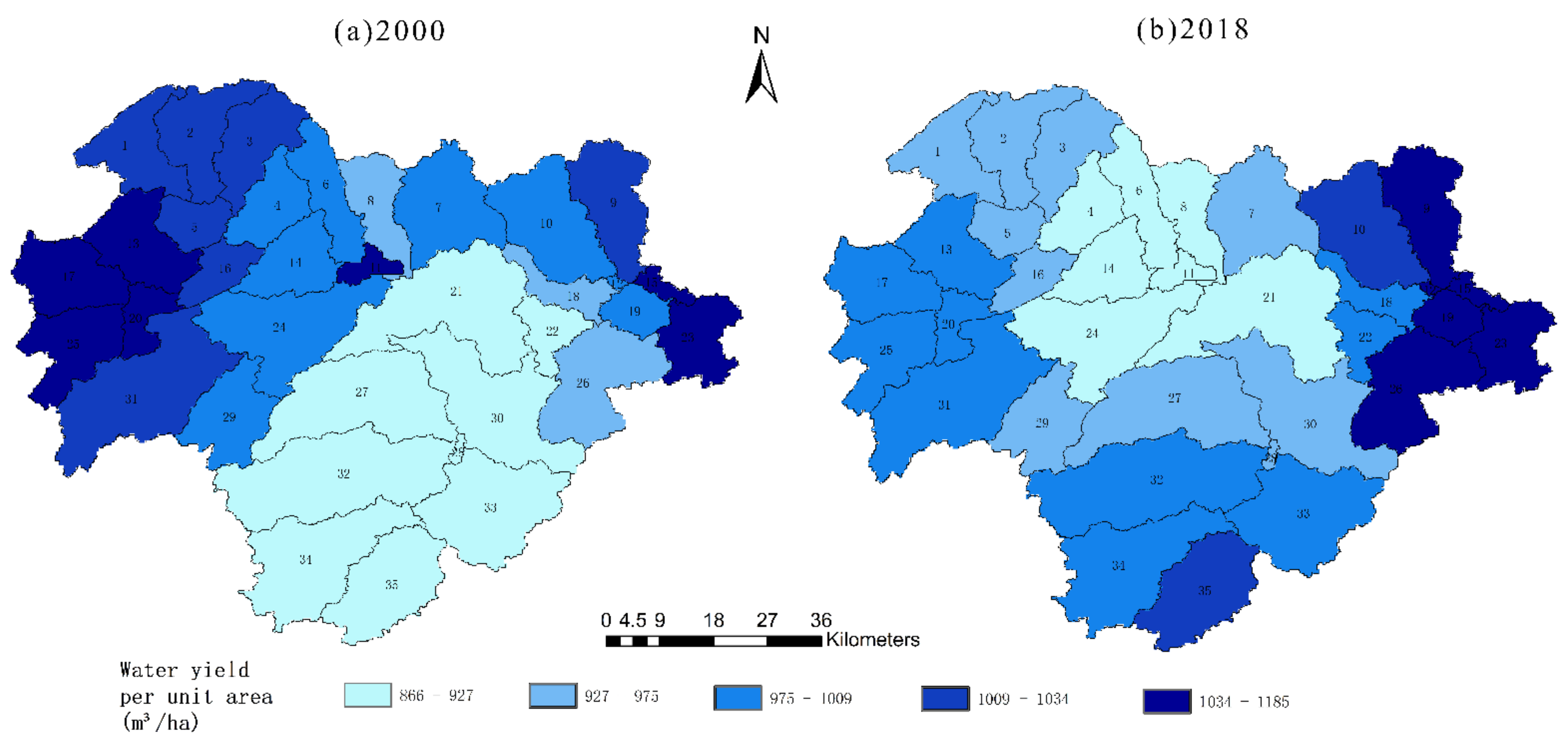
3.2. Freshwater Ecosystem Service Supply

We verified the water production of the InVEST model using measured flow data (measured runoff at Xiangxiang Hydrological Station), which proved to be suitable for studying the water production of the basin. The total water supply volumes of the Lianshui River Basin were 4.15 and 4.21 billion m3 in 2000 and 2018, respectively, and the changes in water production capacity showed a slight upward trend from a numerical point of view. The temporal and spatial heterogeneity of freshwater supply was shown in Figure 4. It can be clearly seen that the water yield capacity of the upper and lower reaches of the Lianshui River Basin was relatively strong, while that of the central region was weak.
Keeping climate data fixed at 2000 values and only incorporating the effects of land-use change, we modeled the water supply in 2000 and 2018 (Figure 5). The total water supply changed from 4.15 to 4.20 billion m3, an increase of 0.05 billion m3. The increase in the area of arable land, woodland, grassland, wetland, and water area all led to different degrees of reduction in water yield, while the increase in the area of built-up land and bare land increased water supply. The reason was that the impervious layer of construction land was formed, and rainfall infiltration capacity became weaker. Similarly, the water-locking capacity of bare land was weak, and most of the precipitation flowed away directly.

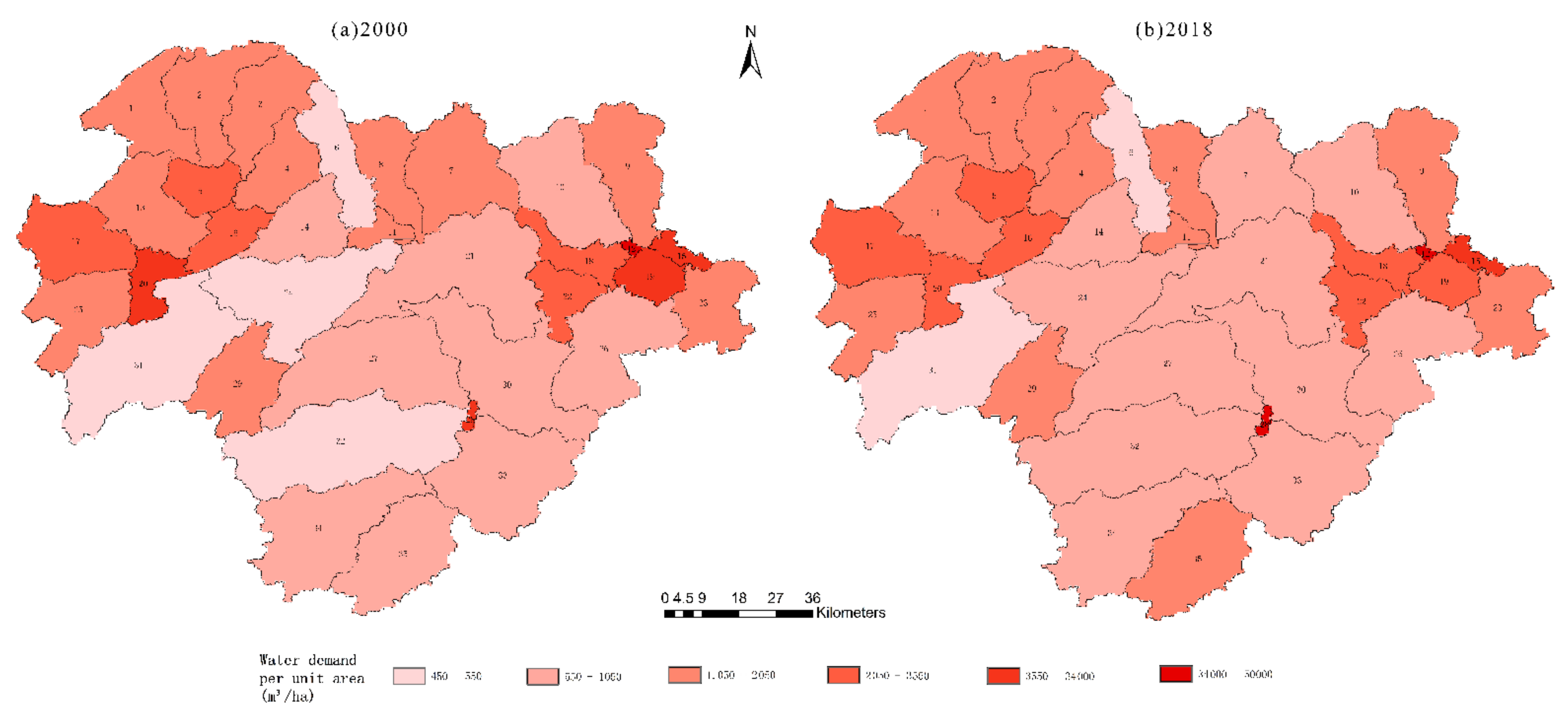
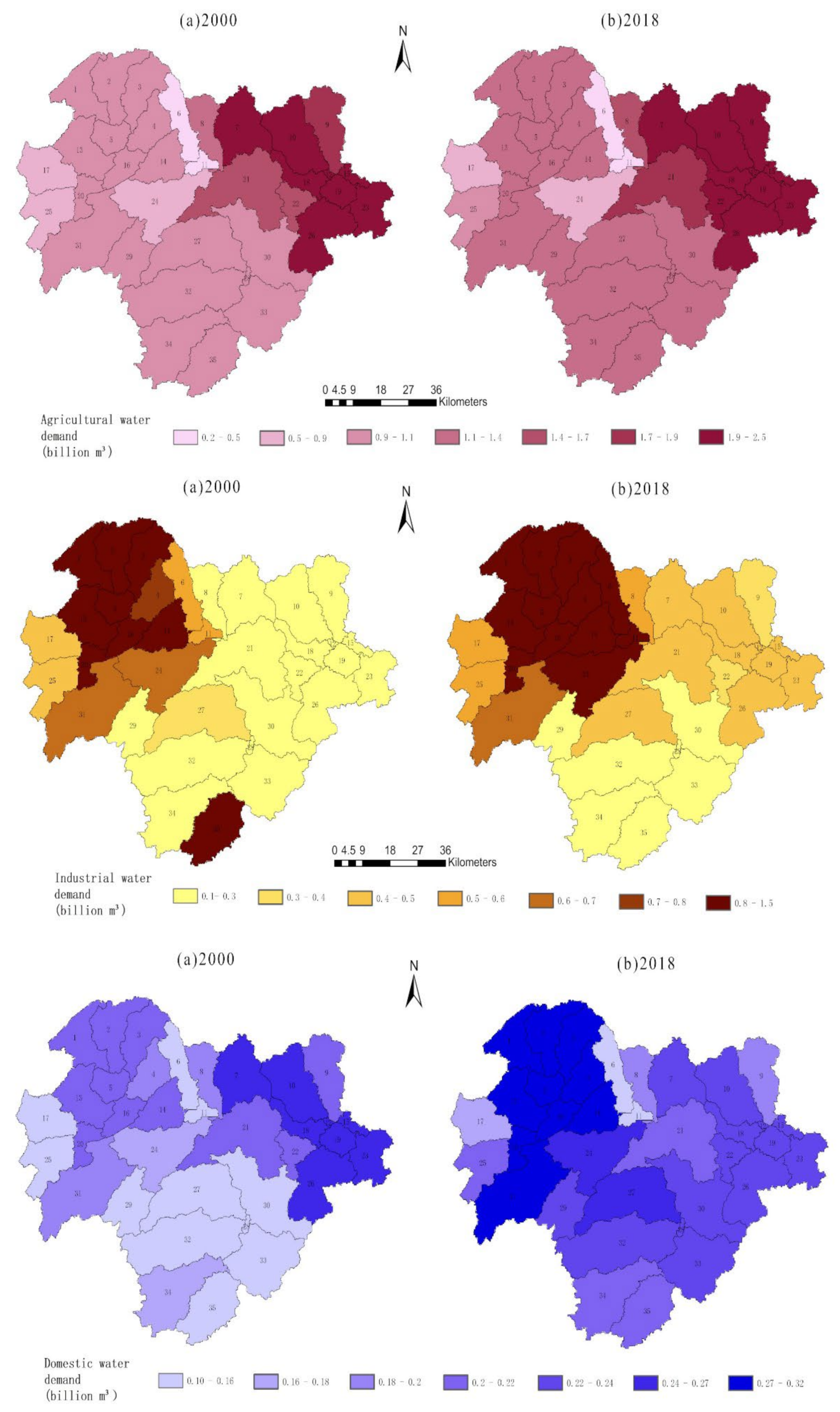
3.3. Freshwater Ecosystem Service Demand

From 2000 to 2018, the total water demand showed an increasing trend, reaching 9.67 and 12.09 billion m3, respectively. And the spatial distribution has shown in Figure 6. As can be seen in Figure 7, agricultural water demand, industrial water demand, and domestic water demand have increased to varying degrees, and the spatial distribution was different. Agricultural water demand was the largest type of water use in the basin. The high-value areas for agricultural water demand use were located in the lower reaches of the basin, and those for industrial water use were located in the middle and upper reaches of the basin, while domestic water demand was concentrated in several central counties and cities. Various types of water demand were closely related to the local population, socio-economic development, and land-use types.
Different from changes in water supply, all land-use changes and water demand from 2000 to 2018 have a positive correlation, even some small land-use changes, such as wetlands and water. Changes in construction land and grassland have the greatest correlation with water demand, mainly because urbanization has led to an increase in population and a substantial increase in water demand (Figure 8).

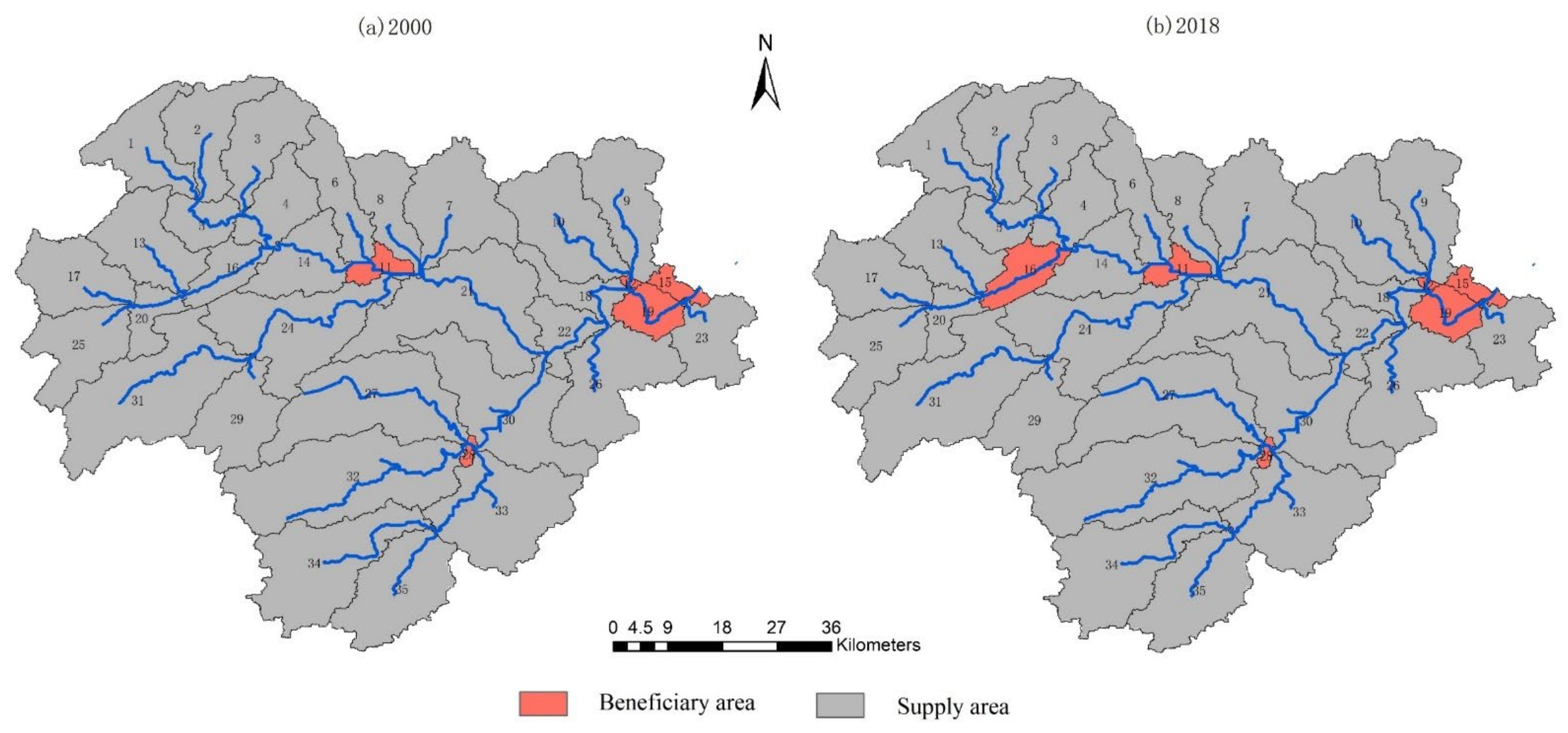
3.4. Freshwater Ecosystem Service Flows

In our research into the freshwater ecosystem service flow based on the flow water security index, the sub-catchment that cannot meet the actual water demand by its water supply and needs to be supplemented by the upstream sub-catchment water was called the beneficiary area; otherwise, it was called the supply area, and the direction of the service flow was consistent with the direction of water flow. In 2000, sub-basins 11, 12, 15, 19, and 28 have all experienced freshwater shortages (Figure 9). This situation intensified in 2018, and the area of freshwater shortages has expanded (sub-basin16). Compared to 2000, freshwater ecosystem service flows decreased by 6% in 2018 under land-use change.

4. Discussion

We quantitatively assessed the impact of land-use change on freshwater ecosystem service flows in the Lianshui River Basin between 2000 and 2018. Deforestation and urban expansion have shifted land-use from cultivated land and forest land to construction land. Changes in land-use had a small positive impact on the supply of freshwater ecosystem services, but the increased industrial and agricultural water demand had a larger impact, resulting in a 6% reduction in the flow of freshwater ecosystem services across the study area. Land-use change influences the flow of freshwater ecosystem services by affecting hydrological processes and human water use. In the past 20 years, China’s development speed has been unprecedented, and the trend of urbanization is obvious. Its main manifestation was the decrease of woodland and the increase of built-up land [39]. The land-use change in Lianshui River Basin has this obvious characteristic. Through this research, we found that, from 2000 to 2018, the most intense land-use transfer method in the Lianshui River Basin was the transfer of forest land to cultivated land and cultivated land to construction land, which was related to local urban intensification, deforestation, and other human behaviors. The Louxing District of Loudi City has developed rapidly in recent years, with a GDP growth rate of 4.4%, and the expansion of its surrounding towns was also very obvious. Overall, the supply of freshwater ecosystem services in the Lianshui River Basin increased under land-use changes.
The increase in impervious surface due to urbanization may lead to a decrease in soil water retention and soil moisture. However, additional water supplies caused by changes in more impermeable surfaces were limited, suggesting that land-use change had little positive impact on freshwater supplies. Water demand is strongly influenced by changes in land-use and associated changes in domestic, agricultural, and industrial water use, compared with a slight impact on water supply. During the study period, the area of agricultural land decreased, but the irrigation water demand per mu increased gradually. It was also mentioned before that the rapid economic development of Louxing District of Loudi City is closely related to the increase of its industrial enterprises. From 2016 to 2018 alone, Louxing District added 57 new industrial enterprises above designated size, which greatly increased the demand for industrial water. For domestic water demand, under the control of the water quota policy, the average annual water consumption of residents has declined, but the water demand is related to the population. The population of the study area has been increasing steadily, which also increases the domestic water demand. These combined have resulted in a substantial increase in water demand in the study area. Changes in demand have a far greater impact on the flow of freshwater ecosystem services than changes in water supply due to land-use changes. Therefore, we should pay more attention to the management of water demand, especially in the downstream areas, than the management of the landscape pattern.
At present, the most widely used quantitative methods in the research of ecosystem service flow include the matrix method, the distributed model method, and the ecosystem cascade framework method [40,41,42]. The InVEST model has obvious advantages in stimulating the supply of freshwater ecosystems, such as few parameters and good adaptability [43,44]. However, the spatial role of water supply services was very complicated. Although measured data were used for model verification, there were still certain uncertainties and limitations. The simulation process ignored the loss of water resources during the flow period and does not consider groundwater, which may underestimate the water supply capacity. At the same time, due to the difficulty of data acquisition, the model simulation process did not consider the impact of man-made infrastructure (such as reservoirs, retaining dam, and water diversion projects) on the regulation and control of water resources. In future research, the uncertainty of the model should be strengthened, and researchers should attempt to integrate more human activities’ influencing factors and conduct research on ecosystem service flows at various temporal and spatial scales.
Watershed freshwater supply increases with land-use changes and responds differently to changes in land-use types. This is due to the internal flow and base flow generated by different land cover surfaces [16]. In the past, there have been many studies on the impact of land-use change on water supply [21,43], but most of them did not distinguish between the impact of climate change and land-use. We fixed the meteorological data in 2000, stripped off the impact of land-use change, and found that the land-use change in the river basin expanded the impervious layer area and increased the water supply by 0.01 billion m3 from 2000–2018. This conclusion is consistent with the conclusions of [16,45] and others. The increase in construction area has led to an increase in water demand. Compared with the increase in water supply, the water demand has increased more to 2.42 billion m3. The flow of freshwater ecosystem services varies with the relationship between supply and demand, reducing by 6%.
While urbanization promotes the supply of freshwater ecosystem service flows, the resulting increase in water demand and water pollution problems cannot be ignored [46]. The increase in water consumption means an increase in the amount of sewage. The impervious ground can allow nutrients, chemicals, and other pollutants to enter the waterbody along with the surface runoff, resulting in a decline in water quality. The government should weigh regional development and ecological protection, evaluate the priority of ecological compensation, and carry out targeted ecological compensation. For example, the freshwater ecosystem service beneficiary area should compensate the supply area, and the upstream area should compensate the downstream area for water pollution. The government should also have an in-depth understanding of the characteristics of regional water resources and the structure of water resources development and utilization and conduct key supervision on certain areas with low water efficiency, find out the reasons for the low efficiency, and improve the water security of the river basin.

5. Conclusions

Under rapid economic development and urbanization, land-use changes have a profound impact on the supply, demand, and flow paths of freshwater ecosystem services. The response relationship between changes in different land-use types and changes of freshwater ecosystem services flows are discussed in this paper, which can provide scientific reference and support for basing measures to suit local conditions and strengthen ecological protection and governance. As a study area, the Lianshui River Basin has a unique geographical advantage in the Hengyang-Shaoyang-Loudi Arid Corridor, which can be used for reference. We found that, under the rapid economic development, the urbanization area of the Lianshui River Basin gradually expanded from 2000 to 2018. Changes in land-use types have different impacts on freshwater supply and demand. During the study period, the supply of freshwater ecosystem services increased slightly with the increase of built-up land, but the demand increased significantly, and the spatial distribution was uneven, especially the urban population agglomeration, causing the water demand to greatly exceed the supply. The proportion of benefited areas in the basin increased, which was detrimental to the sustainable development of the watershed. We suggest that the upstream should focus on water conservation in agriculture, and the downstream cities should control the per capita water consumption quota, build a water-saving society in an all-around way, and raise the nation’s awareness of water conservation.

Author Contributions

Y.Z. and D.M. designed the research. Y.Z. wrote the article and analyzed the data. Y.Z. and D.M. provided the methods and obtained the results. D.M. provided the basic data and technical support. All authors have read and agreed to the published version of the manuscript.

Funding

This study was supported by the Joint Fund for Regional Innovation and Development of NSFC (U19A2051), the Research Project of Hunan Provincial Water Resources Department (XSKJ 2018179-09), the Key R&D Project of Hunan Province (2017SK2301), and the Construction Program for First-Class Disciplines (Geography) of Hunan Province, China (5010002).

Conflicts of Interest

The authors declare no conflict of interest.

References

  1. Li, D.; Wu, S.; Liu, L.; Liang, Z.; Li, S. Evaluating regional water security through a freshwater ecosystem service flow model: A case study in Beijing-Tianjian-Hebei region, China. Ecol. Indic. 2017, 81, 159–170. [Google Scholar] [CrossRef]
  2. Li, H.; Ye, C.; Hua, J. Impact of Land Use Change on Ecosystem Service Value in Nanchang City. Res. Soil Water Conserv. 2020, 27, 277–285. [Google Scholar] [CrossRef]
  3. Thomas, A.; Masante, D.; Jackson, B.; Cosby, B.; Emmett, B.; Jones, L. Fragmentation and thresholds in hydrological flow-based ecosystem services. Ecol. Appl. 2020, 30, e02046. [Google Scholar] [CrossRef] [PubMed]
  4. La Notte, A.; Dalmazzone, S. Sustainability assessment and causality nexus through ecosystem service accounting: The case of water purification in Europe. J. Env. Manag. 2018, 223, 964–974. [Google Scholar] [CrossRef]
  5. Bujnovský, R. Estimation of benefits from the actual use of inland water ecosystem services in the Slovak Republic. Ekológia 2018, 37, 201–218. [Google Scholar] [CrossRef] [Green Version]
  6. Kaiser, G.; Burkhard, B.; Römer, H.; Sangkaew, S.; Graterol, R.; Haitook, T.; Sterr, H.; Sakuna-Schwartz, D. Mapping tsunami impacts on land cover and related ecosystem service supply in Phang Nga, Thailand. Nat. Hazards Earth Syst. Sci. 2013, 13, 3095–3111. [Google Scholar] [CrossRef] [Green Version]
  7. Tong, H.; Shi, P. Using ecosystem service supply and ecosystem sensitivity to identify landscape ecology security patterns in the Lanzhou-Xining urban agglomeration, China. J. Mt. Sci. 2020, 17, 2758–2773. [Google Scholar] [CrossRef]
  8. Kim, S.; Lee, J.; Jeon, S.; Lee, M.; An, H.; Jung, K.; Park, D. Correlation Analysis between Hydrologic Flow Metrics and Benthic Macroinvertebrates Index (BMI) in the Han River Basin, South Korea. Sustainability 2021, 13, 11477. [Google Scholar] [CrossRef]
  9. Lee, J.W.; Lee, S.W.; An, K.J.; Hwang, S.J.; Kim, N.Y. An estimated structural equation model to assess the effects of land use on water quality and benthic macroinvertebrates in streams of the Nam-Han River System, South Korea. Int. J. Environ. Res. Public Health 2020, 17, 2116. [Google Scholar] [CrossRef] [Green Version]
  10. Gao, X.; Huang, B.; Hou, Y.; Xu, W.; Zheng, H.; Ma, D.; Ouyang, Z. Using Ecosystem Service Flows to Inform Ecological Compensation: Theory & Application. Int. J. Environ. Res. Public Health 2020, 17, 3340. [Google Scholar]
  11. Kim, D.H.; Chon, T.S.; Kwak, G.S.; Lee, S.B.; Park, Y.S. Effects of land use types on community structure patterns of benthic macroinvertebrates in streams of urban areas in the South of the Korea Peninsula. Water 2016, 8, 187. [Google Scholar] [CrossRef] [Green Version]
  12. Vrebos, D.; Staes, J.; Vandenbroucke, T.; D׳Haeyer, T.; Johnston, R.; Muhumuza, M.; Kasabeke, C.; Meire, P. Mapping ecosystem service flows with land cover scoring maps for data-scarce regions. Ecosyst. Serv. 2015, 13, 28–40. [Google Scholar] [CrossRef]
  13. Brauman, K.A. Hydrologic ecosystem services: Linking ecohydrologic processes to human well-being in water research and watershed management. Wiley Interdiscip. Rev. Water 2015, 2, 345–358. [Google Scholar] [CrossRef]
  14. Zhang, X.; Fan, J.; Cheng, G. Modelling the effects of land-use change on runoff and sediment yield in the Weicheng River watershed, Southwest China. J. Mt. Sci. 2015, 12, 434–445. [Google Scholar] [CrossRef]
  15. Liu, Y.; Zhang, X.; Xia, D.; You, J.; Rong, Y.; Bakir, M. Impacts of Land-Use and Climate Changes on Hydrologic Processes in the Qingyi River Watershed, China. J. Hydrol. Eng. 2013, 18, 1495–1512. [Google Scholar] [CrossRef]
  16. Migliorini, G.H.; Romero, G.Q. Warming and leaf litter functional diversity, not litter quality, drive decomposition in a freshwater ecosystem. Sci. Rep. 2020, 10, 20333. [Google Scholar] [CrossRef]
  17. Qin, K.; Liu, J.; Yan, L.; Huang, H. Integrating ecosystem services flows into water security simulations in water scarce areas: Present and future. Sci. Total Environ. 2019, 670, 1037–1048. [Google Scholar] [CrossRef]
  18. Zeng, S.; Liu, Z.; Kaufmann, G.; Zeng, Q.; Chen, B. Seasonal and diurnal variations in DIC, NO3−and TOC concentrations in spring-pond ecosystems under different land-uses at the Shawan Karst Test Site, SW China: Carbon limitation of aquatic photosynthesis. J. Hydrol. 2019, 574, 811–821. [Google Scholar] [CrossRef]
  19. Zhu, Q.; Wang, Y.; Qi, L.; Zhou, W.; Zhou, L.; Yu, D.; Dai, L. A framework of freshwater services flow model into assessment on water security and quantification of transboundary flow: A case study in northeast China. J. Environ. Manag. 2022, 304, 114318. [Google Scholar] [CrossRef]
  20. Zhang, Z.; Zhang, H.; Feng, J.; Wang, Y.; Liu, K. Evaluation of Social Values for Ecosystem Services in Urban Riverfront Space Based on the SolVES Model: A Case Study of the Fenghe River, Xi’an, China. Int. J. Environ. Res Public Health 2021, 18, 2765. [Google Scholar] [CrossRef]
  21. Yang, X.; Chen, R.; Meadows, M.E.; Ji, G.; Xu, J. Modelling water yield with the InVEST model in a data scarce region of northwest China. Water Supply 2020, 20, 1035–1045. [Google Scholar] [CrossRef]
  22. Twisa, S.; Mwabumba, M.; Kurian, M.; Buchroithner, M.F. Impact of Land-Use/Land-Cover Change on Drinking Water Ecosystem Services in Wami River Basin, Tanzania. Resources 2020, 9, 37. [Google Scholar] [CrossRef] [Green Version]
  23. Parvaiz A, M.B. Fayaz A. Seasonal Spatio-Temporal Variability in Temperature over North Kashmir Himalayas Using Sen Slope and Mann-Kendall Test. J. Climatol. Weather Forecast. 2021, 9, 1–12. [Google Scholar]
  24. Aneva, I.; Zhelev, P.; Lukanov, S.; Peneva, M.; Vassilev, K.; Zheljazkov, V.D. Influence of the Land Use Type on the Wild Plant Diversity. Plants 2020, 9, 602. [Google Scholar] [CrossRef] [PubMed]
  25. Campagne, C.S.; Roche, P. May the matrix be with you! Guidelines for the application of expert-based matrix approach for ecosystem services assessment and mapping. One Ecosyst. 2018, 3, e24134. [Google Scholar] [CrossRef]
  26. Koellner, T.; Bonn, A.; Arnhold, S.; Bagstad, K.J.; Fridman, D.; Guerra, C.A.; Kastner, T.; Kissinger, M.; Kleemann, J.; Kuhlicke, C.; et al. Guidance for assessing interregional ecosystem service flows. Ecol. Indic. 2019, 105, 92–106. [Google Scholar] [CrossRef]
  27. Feng, C.; Mao, D.; Zhou, H.; Cao, Y.; Hu, G. Game Modeling and Application Analysis of Green Water Management in the River Basin. Resour. Environ. Yangtze Basin 2018, 27, 2505–2517. [Google Scholar]
  28. Mukhtar, N.N.; Aimrun, W.; Fikri, A.A.; Saufi, M.K.M. Dynamics of potential precipitation under climate change scenarios at Cameron highlands, Malaysia. SN Appl. Sci. 2021, 3, 1–17. [Google Scholar] [CrossRef]
  29. Esquivel, J.; Echeverría, C.; Saldaña, A.; Fuentes, R. High functional diversity of forest ecosystems is linked to high provision of water flow regulation ecosystem service. Ecol. Indic. 2020, 115, 106433. [Google Scholar] [CrossRef]
  30. Yu, M.Y.; Meng, F.; Cui, J. Spatial Analysis of Land Use and Land Cover Changes on the Basis of RS and GIS. Appl. Mech. Mater. 2011, 90, 1711–1714. [Google Scholar] [CrossRef]
  31. Richard, S.; Rebecca, C.-K.; Spencer, W. InVEST 3.2.0 User’s Guide. 2015. Available online: https://invest-userguide.readthedocs.io/en/latest/ (accessed on 22 January 2022).
  32. Zhang, L.; Dawes, W.R.; Walker, G.R. Response of mean annual evapotranspiration to vegetation changes at catchment scale. Water Resour. Res. 2001, 37, 701–708. [Google Scholar] [CrossRef]
  33. Gong, X.; Liu, H.; Sun, J.; Gao, Y.; Zhang, X.; Jha, S.K.; Zhang, H.; Ma, X.; Wang, W. A proposed surface resistance model for the Penman-Monteith formula to estimate evapotranspiration in a solar greenhouse. J. Arid Land 2017, 9, 530–546. [Google Scholar] [CrossRef]
  34. Biao, W.; Xinmin, Z.; Gang, H. Estimation of Reference Crop Evapotranspiration in Northwest China. Earth Sci. 2020, 9, 89–99. [Google Scholar]
  35. Xu, J.; Xiao, Y.; Li, N.; Wang, H. Spatial and Temporal Patterns of Supply and Demand Balance of Water Supply Services in the Dongjiang Lake Basin and Its Beneficiary Areas. J. Resour. Ecol. 2015, 6, 386–396. [Google Scholar]
  36. MEA. Millenium Ecosystem Assessment: Ecosystems and Human Well-Being-Synthesis; Island Press: Washington, DC, USA, 2005. [Google Scholar]
  37. Johnson, G.W.; Bagstad, K.J.; Snapp, R.R.; Villa, F. Service Path Attribution Networks (SPANs). Int. J. Agric. Environ. Inf. Syst. 2012, 3, 54–71. [Google Scholar] [CrossRef] [Green Version]
  38. Bagstad, K.J.; Johnson, G.W.; Voigt, B.; Villa, F. Spatial dynamics of ecosystem service flows: A comprehensive approach to quantifying actual services. Ecosyst. Serv. 2013, 4, 117–125. [Google Scholar] [CrossRef]
  39. Sun, Y.; Liu, S.; Dong, Y.; An, Y.; Shi, F.; Dong, S.; Liu, G. Spatio-temporal evolution scenarios and the coupling analysis of ecosystem services with land use change in China. Sci. Total Environ. 2019, 681, 211–225. [Google Scholar] [CrossRef]
  40. Smit, I.P.J.; Roux, D.J.; Swemmer, L.K.; Boshoff, N.; Novellie, P. Protected areas as outdoor classrooms and global laboratories: Intellectual ecosystem services flowing to-and-from a National Park. Ecosyst. Serv. 2017, 28, 238–250. [Google Scholar] [CrossRef]
  41. Owuor, M.A.; Icely, J.; Newton, A.; Nyunja, J.; Otieno, P.; Tuda, A.O.; Oduor, N. Mapping of ecosystem services flow in Mida Creek, Kenya. Ocean Coast. Manag. 2017, 140, 11–21. [Google Scholar] [CrossRef]
  42. Zank, B.; Bagstad, K.J.; Voigt, B.; Villa, F. Modeling the effects of urban expansion on natural capital stocks and ecosystem service flows: A case study in the Puget Sound, Washington, USA. Landsc. Urban Plan. 2016, 149, 31–42. [Google Scholar] [CrossRef]
  43. Yang, D.; Liu, W.; Tang, L.; Chen, L.; Li, X.; Xu, X. Estimation of water provision service for monsoon catchments of South China: Applicability of the InVEST model. Landsc. Urban Plan. 2019, 182, 133–143. [Google Scholar] [CrossRef]
  44. Ke, X.; Wang, L.; Ma, Y.; Pu, K.; Zhou, T.; Xiao, B.; Wang, J. Impacts of Strict Cropland Protection on Water Yield: A Case Study of Wuhan, China. Sustainability 2019, 11, 184. [Google Scholar] [CrossRef] [Green Version]
  45. Ervinia, A.; Huang, J.L.; Zhang, Z.Y. Land-use changes reinforce the impacts of climate change on annual runoff dynamics in a southeast China coastal watershed. Hydrol. Earth Syst. Sci. 2015, 12, 6305–6325. [Google Scholar]
  46. Huang, J.L.; Li, Q.S.; Pontius, R.G., Jr.; Klemas, V.; Hong, H.S. Detecting the dynamic linkage between landscape characteristics and water quality in a subtropical coastal watershed, Southeast China. Environ. Manag. 2013, 51, 32–44. [Google Scholar] [CrossRef]
Figure 1. DEM and location (a) and river system and sub-basin division (b) of the Lianshui River Basin from 2000–2018.
Sustainability 14 03270 g001
Figure 2. Schematic diagram of freshwater ecosystem service flow model.
Sustainability 14 03270 g002
Figure 3. The map of land-use changes in Lianshui River Basin from 2000 to 2018.
Sustainability 14 03270 g003
Figure 4. Spatial distribution of water supply.
Sustainability 14 03270 g004
Figure 5. Changes in water supply under land-use changes.
Sustainability 14 03270 g005
Figure 6. Spatial distribution of water demand.
Sustainability 14 03270 g006
Figure 7. Spatial distribution of water consumption in different industries.
Sustainability 14 03270 g007
Figure 8. Changes in water demand under land-use changes.
Sustainability 14 03270 g008
Figure 9. Spatial distribution map of freshwater ecosystem service flow in Lianshui River Basin.
Sustainability 14 03270 g009
Table 1. The data type and data sources.
TypeData Sources
Digital elevation model (30 m resolution)Geospatial Data Cloud (https://www.gscloud.cn/)
(accessed on 23 January 2022)
Land-use/cover dataChinese Academy of Sciences Resource and Environmental Science Data Center (http://www.resdc.cn/)
(accessed on 23 January 2022)
Meteorological data (precipitation, temperature)
Hydrological data (runoff)The Hydrological Bureau of Hunan Province
Water demand dataWater Resources Bulletin of Hunan province
Socioeconomic data (county scale)Statistical Yearbook(http://slt.hunan.gov.cn/)
(accessed on 23 January 2022)
Table 2. Biophysical table used for the baseline InVEST water yield model run, giving the information about vegetation, plant evapotranspiration coefficient Kc, and root depth for each LULC class.
LucodeLULC_DescRoot_DepthKcLULC_Veg
1arable land16001.0551
2woodland45001.0081
3grassland20000.8651
4wetland100011
5water101.050
6built-up land00.20
7bare land5000.150
Table 3. Average annual water use of agriculture, residents, and industry.
YearCityCagr (m3/ha)Cind (m3/104 GDP)Cdomu (L/d·Person)Cdomr (L/d·Person)
2000Shaoyang9015483156114
Loudi8209326163118
Xiangtan8955295163120
2018Shaoyang904415815392
Loudi85449615095
Xiangtan899096150101
Table 4. The structure of land-use in Lianshui River Basin in 2000, 2018.
200020182000–2018
Area (km2)Percentage (%)Area (km2)Percentage (%)Area (km2)Percentage (%)
Arable land2288.2738.662259.2538.17−29.02−0.49
Woodland2478.9541.882409.2040.7−69.75−1.18
Grassland1010.9417.08988.4116.71−22.53−0.37
Wetland2.670.050.100.002−2.57−0.048
Water71.121.289.361.5+18.24+0.3
Build-up land67.081.13168.612.85+101.53+1.72
Bare land0.0004.090.068+4.09+0.068
Table 5. Land-use transfer matrix in Lianshui River Basin from 2000 to 2018 (km2).
2018
Arable LandWoodlandGrasslandWetlandWaterBuild-Up LandBare Land
2000Arable land2182.4725.073.98028.2069.580.86
Woodland70.332354.3721.8702.9219.821.93
Grassland11.8617.35945.4400.4919.961.29
Wetland0.440.050.040.092.0500
Water9.553.362.350.0155.130.610
Build-up land4.323.090.5200.5758.570
Publisher’s Note: MDPI stays neutral with regard to jurisdictional claims in published maps and institutional affiliations.

