Article

Human Activity Intensity in China under Multi-Factor Interactions: Spatiotemporal Characteristics and Influencing Factors

1
School of Geography and Environment, Shandong Normal University, Jinan 250014, China
2
Office of President and Party Committee, Shandong Women’s University, Jinan 250300, China
3
Shandong Provincial Land and Space Planning Institute, Jinan 250014, China
4
Institute of Applied Ecology, Chinese Academy of Sciences, Shenyang 110016, China
*
Author to whom correspondence should be addressed.
Sustainability 2022, 14(5), 3113; https://doi.org/10.3390/su14053113
Submission received: 9 February 2022 / Revised: 27 February 2022 / Accepted: 28 February 2022 / Published: 7 March 2022

Abstract

:
Human activities involving nature have various environmental impacts. The assessment of the spatial and temporal evolution of human activity intensity (HAI) and its driving forces is significant for determining the effects of human activities on regional ecological environments and regulating such activities. This research quantified the HAI of China, assessed its spatiotemporal characteristics, and analyzed its influencing factors based on the land use data and panel data of 31 provinces in mainland China. The results indicate that the HAI in China is increasing, with the average value increasing from 15.83% in 1980 to 20.04% in 2018, and the HAI was relatively serious in the Beijing–Tianjin–Hebei region, Yangtze River Delta and Pearl River Delta in this period. The spatial differences in the HAI in China show a pattern of being strong in the east and weak in the west, and the spatial center of gravity of China’s HAI has gradually moved west, changing from a central enhancement mode to a point-like “core” enhancement mode. The dominant factors affecting spatial differences in HAI are economic and industrial levels. Labor, population, and capital factors also strongly impact HAI, and energy consumption and pollution emissions have little impact. These results deepen the understanding of the underlying mechanism of the environmental impact of human activities and provide a scientific basis for land-use-related decision making and eco-environment construction.

1. Introduction

Human activity is a series of actions imposed on the ecosystem by human beings for their own development needs and is a relatively broad concept that includes humans’ exploitation of land resources, use of natural resources, and environmental protection activities [1]. The impact of such human activity on ecosystems is best reflected by land use type. This impact is further reflected in the industrialization and urbanization of each country. Research shows that human activity is driving economic development worldwide [2]. For example, the urbanization rate in China increased by 41.95% from 1978 to 2018, making it one of the fastest growing countries in the world. However, an increasing number of studies also confirm that continued urbanization and industrialization mean that human demand for land resources is increasing [3,4]. In this context, the increasing ability of humans to transform nature has brought enormous pressure to the ecosystem, making the originally fragile ecological environment deteriorate continuously [5,6]. If human activities are not effectively controlled, there will be a serious threat to global ecological security and sustainable development. Therefore, the quantitative and spatial expression of human activity intensity (HAI) is the basis for evaluating the impact of human activities on the ecological environment and provides a theoretical basis for the rational utilization of land resources and eco-environment protection planning [7,8].
As noted, human activity is the relatively broad concept of a series of behaviors imposed by human beings on the environment for their own development needs. The concept of human activity can be traced back to the 18th century [9], but the evaluation and measurement of HAI started later and has led to a variety of measurement methods [10,11]. The large-scale measurement of human activities began in 1994. Hannah et al. [12] measured the degree of human interference with the global natural habitat. Past research shows that most habitable areas have been affected by human activities. In the 21st century, scholars have conducted more in-depth research on human activities, and their measurement methods and research subjects have become more diverse. These measurement methods are mainly divided into two groups. On the one hand, based on the changes caused by humans themselves and the environmental changes caused by human activities [13,14], Magalhães et al. [15] and Roth et al. [16] constructed a human activity index system based on the overlay analysis of multiple indicators. The research shows that human activities destroy local lands and ecosystems. On the other hand, the land surface environment is constantly affected or even altered by human activities, resulting in changed land use types. This means that land use change can reflect human activity intensity [17]. In recent years, Xu et al. [18] have widely recognized the construction land equivalent of various land use types as a way to measure HAI. This method can eliminate regional differences and accurately measure a wide range of regions with different spatial characteristics. In terms of research content, at this stage, the research on human activities has achieved good interaction with the fields of ecological environment, climate and social development, which can be used to explore the comprehensive situation of cities [19]. For example, Sun et al. [20] measured HAI on the Qinghai–Tibet Plateau and combined it with the value of ecosystem services, concluding that HAI on the Qinghai–Tibet Plateau increased slightly and that the ecosystem was basically stable. Zhang and Xu [21] believe that HAI interacts strongly with local production life ecological functions, which is an important factor affecting regional sustainable development. Chen et al. [22] took the POI data of Shanghai, China as a measurement standard to explore the relationship between HAI and night light. Although the measurement methods and research areas related to HAI differ, their purpose is consistent: to regulate regional ecological pressure and realize regional sustainable development.
To date, scholars have conducted extensive research on human activities. However, the existing research on human activity offers only an insufficient analysis and mainly focuses on temporal and spatial changes in human activities and the interactions between human activities and a single area of environmental concern [23,24,25]. On the one hand, there is a lack of comparative research on large-scale regions; on the other hand, there are few studies on the influencing factors of HAI or that use multiangle analysis, most studies use traditional methods for analysis. It is difficult to quantify the effect of single factors on human activities using traditional linear regression and correlation analysis methods. This is because the relationship between two variables may be affected by other factors. Compared with other correlation analysis methods, the geographical detector method (GDM) effectively identifies the contribution of a single factor and the interaction among influencing factors and better solves the effects of spatial location. Many study fields have begun to use GDM to quantify the influence of factors explaining the temporal and spatial evolution of geographical phenomena. For example, GDM has been used in the study of air pollution [26], built-up land expansion [27], and agricultural [28] and human health [29]. Given this, we use the geographical detector technique in this paper to explore HAI under the influence of multiple factors. This paper aims to explore the factors involved in HAI changes in the situation of rapid socioeconomic development in China since the reform and opening-up began and to analyze the reasons for the regional differentiation of human activities so as to help control human activities, achieve sustainable development, and effectively alleviate the tension between humans and the land, which is very significance for maintaining the stability of the ecosystem and high-quality development.

2. Data and Methodology

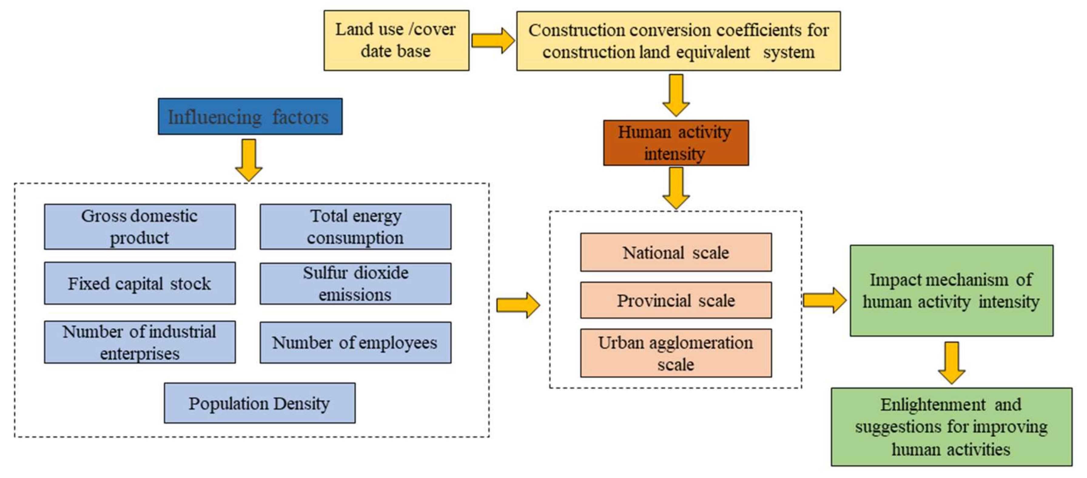
2.1. Conceptual Framework

The main purposes of this paper are to explore the regional differences and the changing rules of human activity intensity in mainland China and to identify the impact of influencing factors on human activity intensity in China. First, we measure the intensity of human activities from 1980–2018 by using ArcGIS 10.6 software based on land use data and construction land equivalent conversion coefficients. Second, the time-space pattern of human activity intensity is explored from multiple perspectives. Third, influencing factors are identified based on related studies. Finally, the interactive effect of each influencing factor on human activity intensity is studied based on the geographic probe approach. The technical framework of the study is illustrated in Figure 1.

2.2. Data Sources

This study takes 31 provincial administrative regions in China as the research object. According to existing research, in areas with a better level of economic development, human exploitation of the land and disturbance of the ecological environment are more intense than in other areas. Therefore, we choose China’s three major economic centers (Beijing–Tianjin–Hebei region, the Yangtze River Delta, and the Pearl River Delta) as the subjects of our study at the city cluster scale [30]. The comparison of these regions can help in analyzing whether economically developed regions are taking measures to control human activities. The resolution of the land use data involved in the study is 30 m, which comes from the Resource and Environmental Science and Data Center of the Chinese Academy of Sciences (http://www.resdc.cn/, accessed on 29 November 2021). The socioeconomic statistical data are mainly from the China Statistical Yearbook, China Energy Statistical Yearbook, China Urban Statistical Yearbook and provincial statistical yearbooks. Among them, the data of total energy consumption of Tibet and Hainan in 1990, and the data of fixed capital stock of some cities in 1983 and 1987 are missing. The missing panel data are obtained by data interpolation of adjacent years.

2.3. Identification of Influencing Factors

The identification of factors influencing HAI is a complex task. By referring to relevant research literature [21,31,32], it is known that human activities are generally related to urbanization, population, industrial activities, agricultural activities, economic activities, energy consumption. Therefore, we based on 31 provincial administrative regions comprehensively and consider the changes in human activities in China. We selected influencing variables referring to economic, capital, industrial, energy consumption, pollution, labor, and demographic factors as indicators to explore the changes in HAI. Considering that arable land is one of the land use types, its area is the basis for assessing HAI, and the resources consumed by human for agricultural activities are less. Therefore, this study did not consider agricultural activities as one of the influencing factors for human activity intensity. Table 1 shows statistical information for each of the variables.
(1).
Economic factors. Regional GDP is a macro indicator used to measure the level of national or regional economic development, and it is also one of the most common and important standards for measuring development. Economic development is the main purpose of human activities. There may be ecological and environmental problems caused by human activities that prioritize the speed of economic development over other effects. Therefore, economic factors, represented by regional GDP, are regarded as one of the factors affecting HAI.
(2).
Capital factors. Capital factors are an important index affecting industrial structure. Reasonable capital flow is not only the basis and premise of realizing the optimization of economic and industrial structure but also a factor that affects HAI. To accurately measure the impact of capital factors on human activities, this paper uses the perpetual inventory method to calculate the fixed capital stock. Referring to the calculation methods of Li [33] and Wu [34], this paper selects the depreciation rate of fixed assets in corresponding provinces, makes a reduction based on 1980, and finally, obtains the fixed capital stock.
(3).
Industrial factors. The number of industrial enterprises can reflect the industrial scale of a region. It is an important indicator of the degree of regional industrialization and significantly affects the development of land by human activities. Therefore, the number of industrial enterprises is regarded as one of the indicators affecting HAI.
(4).
Energy consumption factors. Under the current international trend of “carbon peaking and carbon neutralization”, China is facing the dual pressures of ensuring energy supply and protecting the ecological environment, and the impact of energy factors on regional economies and industries is becoming increasingly serious. Although controlling the total energy consumption will limit economic development to a certain extent, it is conducive to reducing carbon emissions and controlling HAI [35]. Therefore, we take the total energy consumption, representing energy factors, as one of the influencing factors to detect HAI.
(5).
Pollution factors. Sulfur dioxide emitted in the process of industrial production is the main source of pollution; such pollution factors can reflect the type and scale of regional industries. An excessive intensity of human activities will inevitably lead to an increase in regional pollutants. Therefore, sulfur dioxide emissions are selected as an influencing factor of HAI.
(6).
Labor factors. Regional economic development and industrial enterprise production inevitably require a large labor force. A reasonable labor force distribution among regions is conducive to the allocation of market resources and the adjustment of HAI. Therefore, the number of employees is selected to represent the impact of labor factors on HAI.
(7).
Demographic factors. China has the largest population of any country in the world. As population size is the main body of HAI [36], population density is selected as an influencing factor of HAI.

2.4. Methodology

2.4.1. Human Activity Intensity Model

Human activity intensity is an indicator that reflects the strength of human activity in a certain area through the land use type. The formula of the HAI model is:
S j = i = 1 n ( S i C i )
HAI = S j S × 100 %
where HAI is the value of human activity intensity; Sj is the area of equivalent construction land; Si is the area of the ith land use type in the study area; S is the total area of the study area; and n is the number of land use types; Ci is the coefficient of construction land equivalent converted by the ith land use type, which are time-invariant. This means that the same coefficients were used for one land use type during the study period.
In this study, we refer to the Xu, Xu and Tang [18] index system of construction land to equate to different land use types. The system is constructed by a step-by-step two-level algorithm used to characterize the degree of interference of human activities on various types of land. The advantage of this method is that it provided refined classification standards. Regional differences caused by the vast size of China’s territory have been eliminated as much as possible. In addition, we use ArcGIS 10.6 to calculate HAI on 10-km grid units to show regional differences. HAI in various provinces in China is divided into five levels using the natural breakpoint method: very low (less than 5%), low (5–12%), medium (12–19%), high (19–26%) and very high (more than 26%).

2.4.2. The Standard Deviational Ellipse Method

Standard deviational ellipse (SDE) analysis is a method for measuring the spatial distribution of a set of points or areas by calculating the standard distance separately in the x and y directions [37]. The spatial distribution law and evolution trend of geographical elements are quantitatively described by taking the center of gravity, azimuth and primary and secondary coordinate axes of the ellipse as parameters [38]. The larger the value difference between the primary and secondary coordinate axes, the more obvious the directionality of geographical elements. This study uses the standard deviation ellipse to explore the spatial characteristics of HAI changes from multiple angles [39]. The standard deviation ellipse is calculated as follows:
X ¯ = i = 1 n x i n , Y ¯ = i = 1 n y i n
S D E x = i = 1 n ( x i X ¯ ) 2 n , S D E y = i = 1 n ( y i Y ¯ ) 2 n
where X ¯ and Y ¯ represent the coordinates of the spatial barycenter for the HAI; xi and yi are the longitude and latitude of each subregion i, respectively; and n is the total number of study areas. SDEx and SDEy represent the major and minor axes of the ellipse. By using the SDE method in ArcGIS 10.6, the directivity of the spatial distribution of HAI can be visualized.

2.4.3. Geographic Detector Method (GDM)

The GDM is a new spatial statistical method that is mainly used to detect spatial differentiation in the ecological and geographical sense [40]. This paper uses single factor detection and factor interaction detection in GDM to analyze the human activities intensity in 31 provincial administrative regions of China and reveals the influence degree and coupling interaction of each factor. This means that if a factor is associated with human activity intensity, the spatial distribution of human activity intensity is similar to the spatial distribution of that factor. The calculation formula is [41]:
q = 1 1 K w 2 n = 1 M K n w n 2
where q is the power of the determinant, and its value is within the range [0,1]. K and Kn represent the number of study areas and the number of units in the divided study area, respectively, M represents the number of index samples, and w 2 and w n 2 represent the variance of the study area and the variance of the subareas, respectively.
Factor interaction detection refers to evaluating the impact of the joint action of two factors on the level of human activities by judging the interaction between two factors in all detection factors. The interaction between two factors can be divided into the following five types (Table 2).

3. Results

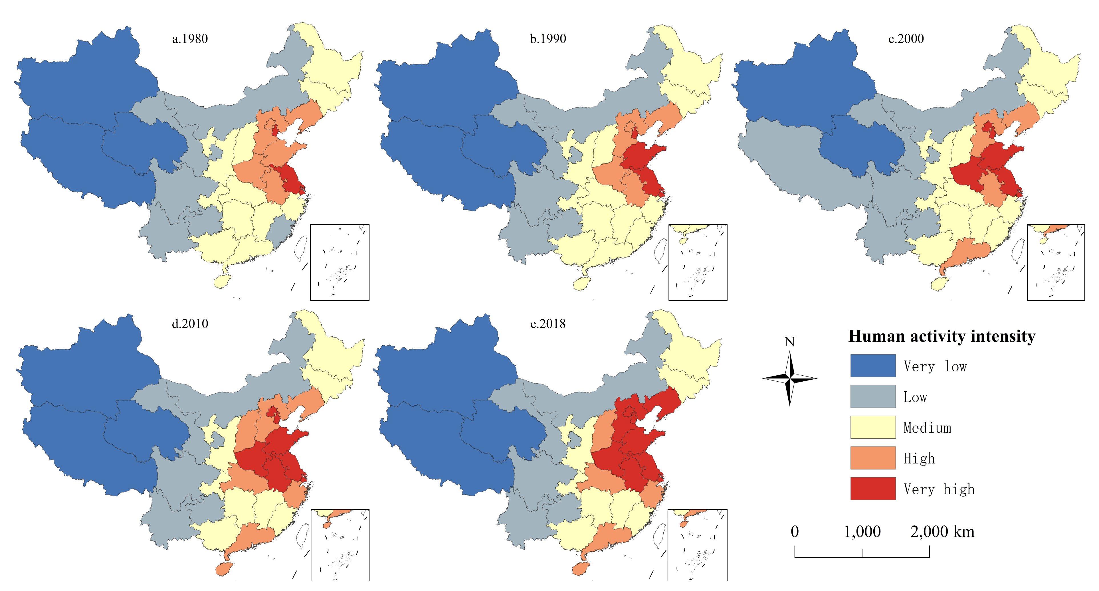
3.1. Characteristics of Human Activity Intensity in China

3.1.1. Temporal and Spatial Characteristics of Human Activity Intensity in China

Figure 2 shows that the HAI in China exhibited an upward trend from 1980 to 2018. Indeed, the HAI in China increased from 15.27% in 1980 to 18.42% in 2018, an increase of 20.60%; the growth rate from 2000 to 2010 was the largest. In 1980, the equivalent area of construction land was 69.93 × 10⁴ km2, and this increased to 78.38 × 10⁴ km2 by 2018, with the largest increase, 4.05 × 10⁴ km2, happening between 2010 and 2018. The results indicate that the highest annual average HAI concentration in the Beijing–Tianjin–Hebei region in the three major economic growth poles reached 32.18% in 2010, and the HAI situations in the Beijing–Tianjin–Hebei region and Yangtze River Delta were the most serious. The HAI in the Pearl River Delta is relatively weak, but it is still significantly higher than the national average. Interestingly, the Beijing–Tianjin–Hebei region saw a slight decline after 2010, but the Yangtze River Delta region rose significantly.
Spatially, the HAI in China varied greatly between the east and west from 1980 to 2018 (Figure 3), showing a decreasing trend from the eastern coastal area to the inland area. The increasing trend is mainly due to a gradual increase in the eastern coastal area and the expansion around the Beijing–Tianjin–Hebei urban agglomeration. The number of provinces with very high HAI levels changed notably, increasing from three provinces in 1980 to nine in 2018, and gradually became concentrated in space. Among these provinces, Tianjin, Jiangsu and Shanghai have consistently reached the very high HAI level.
The HAI in Shandong and Fujian increased from 1980 to 1990, and Fujian’s role in supporting the reform and opening-up policy was initially obvious. During this period, Shandong’s agriculture and industry developed rapidly, and the total economic output value jumped to second highest in the country, reflecting how economic, agricultural and industrial activities increase the intensity of regional human activities to varying degrees. As China’s political center and most populous province, Beijing and Henan, respectively, reached the very high HAI level in 2000. In 2010, human activities in Hubei, Anhui and Zhejiang reached the high or very high HAI levels; these three provinces are in the Yangtze River Basin, indicating that significant changes took place in the Yangtze River Basin during this period, and the rapid expansion of cities and towns caused by key development was the main factor for the increase in human activities there. In 2018, the Bohai Rim region saw concentrated changes in human activities. Liaoning and Hebei reached the very high HAI level, and Beijing and Tianjin both decreased slightly, but they were still at the very high HAI level. In 2017, China established a national new area, the Hebei Xiong’an New Area. The change in policies led to the large-scale development of land in the Xiong’an New Area, which led to the rise of surrounding industries, sharing the pressure of Beijing and Tianjin.

3.1.2. Evolutionary Characteristics of Human Activity Intensity in China

To explore the evolution of HAI in China in greater depth, we calculate the change in HAI on a 10-km grid unit and reveal the evolution of human activity combined with a standard deviation ellipse method (Figure 4) to comprehensively explore the temporal and spatial evolution process of such activities.
From 1980 to 1990, the polarization of HAI in China was significant (Figure 4a). The regions with enhanced human activities were mainly concentrated on the eastern coast, Heilongjiang and eastern Hubei Province, showing a significant east-northeast distribution; there were no significant changes in other regions. During this period, the maximum increment of the HAI level reached 10.22%, but the average increment was only 0.15%, which was the lowest value across the entire period. Therefore, the areas where human activities increased from 1980 to 1990 were significantly different from other areas. The standardized ellipse from 1990 to 2000 shows that the region with enhanced human activities extended westward and inland (Figure 4b). The Beijing–Tianjin–Hebei Urban Agglomeration, the Pearl River Delta and the Yangtze River Delta are the most important economic regions in China, and their human activity levels led to them having the largest increments of all regions in this decade (Figure 4c). In turn, this indicates that after the initial vigorous development of economic activities such as foreign trade in coastal areas, China’s human activities became relatively balanced in that decade. From 2000 to 2010, the HAI in China showed a northwest-southeast distribution (Figure 4d). The areas with increased HAI extend to the western inland areas. In comparison, the HAI in western Tibet decreased and those in eastern Tibet increased. The dot growth mode of HAI began to show, and the human activities in Northeast China were basically stable. From 2010 to 2018, the standardized ellipse was distributed in the east-west direction. It is worth noting that the HAI in the Beijing–Tianjin–Hebei Urban Agglomeration and the Yellow River Delta of Shandong decreased slightly, which shows that these areas successfully controlled human activity intensity. In addition, the HAI decreased slightly in southern Yunnan and the Leizhou Peninsula, indicating that the relatively economically backward areas were also affected by a variety of reasons that led to a decrease in human activity. On the whole, the central effect of the enhancement of human activities weakened, and the point distribution mode became more significant.

3.2. Analysis of Influencing Factors

3.2.1. Single Factor Detection Analysis

In this section, we use the geographical detector method to identify the driving factors and their determinant power (q) on HAI. For a more intuitive comparison of q values in all years, the results for the 7 factors are illustrated in a box-whisker plot (Figure 5). The results of single factor detection analysis show that all factors play a driving role in human activities in China to a certain extent, and the power of determinant values can reflect the decisive level of the change in HAI driven by the detected factors. From 1980 to 2018, based on their determinant power, the influencing factors can be ranked as follows in descending order: GDP > NIE> PD > NE > FCS > TEC > SUL.
According to the detected results during the study period, the GDP factor generated a q value from 0.463 to 0.557, indicating a significantly high determinant power of regional gross domestic product on HAI, and economic factors were the main reasons for the regional differences in HAI. To a certain extent, the economic gap between eastern and western China leads to differences in human activities, resulting in the rapid increase in human activities in the eastern region and the slow change in the western region. Among other variables, the determinant power levels of NIE, PD, NE and FCS were ranked second, third, fourth and fifth, respectively. The difference between the four q levels was small. Interestingly, the determinant power level of PD had narrow interquartile ranges and was always high without obvious fluctuation, which indicates that the spatial heterogeneity of HAI was stably influenced by population density. TEC and SUL had relatively wide interquartile ranges, and the determination power level is small and significantly lower than that of other detected factors. In terms of time, the power of the determination level of the two decreased significantly from 2000 to 2010, indicating that TEC and SUL had little impact on human activities.

3.2.2. Multiple Factor Interaction Detection Analysis

The results show that the interaction of any two factors from 1980 to 2018 was greater than the effect of a single factor on human activities (Figure 6). Most of the interactions enhanced the effect of each factor, and most demonstrated nonlinear enhancement and bi-enhancement. This indicates that the comprehensive consideration of multiple driving factors and their interactions can reveal the reasons for the spatial differentiation of HAI more clearly than studying single influencing factors alone.
In 1980, NIE ∩ PD had the most obvious impact on HAI. The q value of interaction detection was as high as 0.667, and the determinant was nearly 67%. In addition, the factors with an impact of more than 60% on HAI included GDP ∩ FCS, GDP ∩ SUL, FCS ∩ PD and NIE ∩ SUL. In 1990, TEC ∩ NE had the strongest impact on HAI, with a decisive force of approximately 65%. Factors with an interaction degree of more than 60% included GDP ∩ NE, FCS ∩ NIE, NIE ∩ TEC, NIE ∩ NE and NE ∩ PD. In 2000, NIE ∩ NE had the strongest decisive power, approximately 68%, followed by NIE ∩ PD, with a decisive power of approximately 64%. Factors with a decisive power of more than 60% also included GDP ∩ SUL, GDP ∩ NE and NIE ∩ SUL. In 2010, the most significant interaction factor affecting HAI was FCS ∩ SUL, with a q value of 0.661 and a determinant of approximately 66%. In addition, the determinants of FCS ∩ TEC, FCS ∩ PD and SUL ∩ NIE were also greater than 60%. In 2018, FCS ∩ NE had the strongest impact on HAI in China, with the decisive power of interactive detection being approximately 70% and the decisive power of FCS ∩ NIE and NIE ∩ SUL on HAI being more than 65%.
Based on the above results, it can be seen that there are differences in the interaction and coupling of factors in different periods. For example, the interaction between economic and demographic factors was the strongest in 1980, the interaction between labor factors and industrial factors was the strongest in 1990–2000, the interaction between capital factors was the strongest in 2010, and the interaction between industrial factors was the strongest in 2018. On the whole, the interaction between industrial factors and other factors was the strongest; that is, the strength of human activities was more vulnerable to interference by industrial factors, resulting in regional differentiation.

4. Discussion

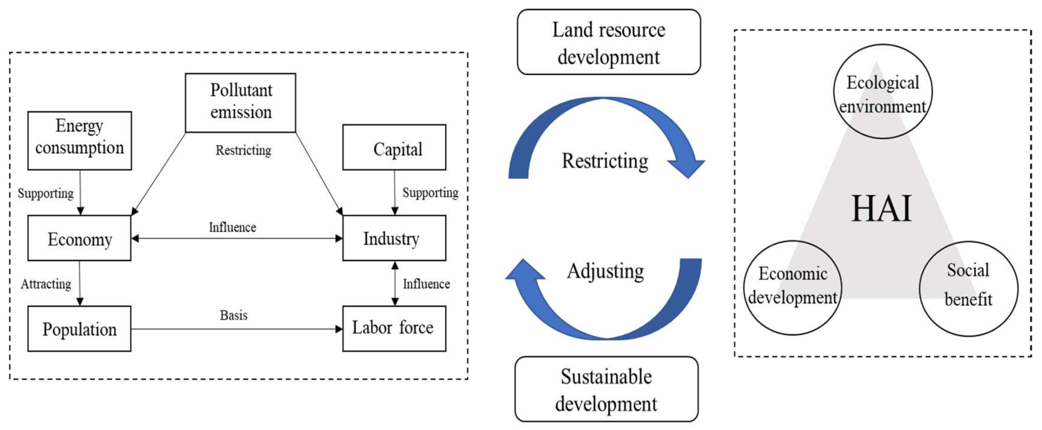
4.1. Implications of Human Activity Intensity

HAI is a comprehensive indicator of human impact on land development. Exploring the temporal and spatial evolution of HAI can help comprehensively evaluate the role of human activities on regional land and the environment by taking the evolution as a basis for coordinating the layout from local to overall to regulate human activities. We comprehensively evaluated HAI in China from 1980 to 2018. Unlike existing studies [32,33,34,35,36,37,38,39,40,41,42,43,44], this paper comprehensively considers multiple dimensions of HAI changes and reveals the spatial heterogeneity of such changes. Although the HAI in the Yangtze River Delta in 2018 was slightly lower than that of the Beijing–Tianjin–Hebei region, its growth trend in the Yangtze River Delta was steeper. Evidence has shown that in the Yangtze River Delta, rapid urbanization intensifies the trend toward land fragmentation and promotes the rapid expansion of construction land [45].
During the study period, HAI in China generally increased, and the changing trends in various regions or provinces varied greatly. For example, from a regional perspective, Northeast China was an important mineral resource center and industrial center in China in the 30 years after the founding of the People’s Republic of China. Human interference in the region was extremely frequent. Before 2000, heavy industry had not yet declined, and human activities were still increasing. In particular, human activities in Heilongjiang increased greatly during that period, but after 2000, the development focus shifted south. The northern coast of Liaoning has become the main area in Northeast China for increased human activities. The coastal areas in northern Shandong are mainly caused by the occupation of a large number of natural wetlands and the excessive coastal construction of cities and towns. Human activities in the coastal areas of northern Shandong decreased after 2010 due to the strengthening of control over the Yellow River Delta and surrounding areas after 2010 so as to reduce human activities and restore the natural landscape. The eastern coastal areas have been more affected by the opening-up policy than other areas and have thus attracted a number of industries, capital investments and migrants. Although the economy is developing rapidly, this development has increased the frequency with which land is developed and constructed. The Beijing–Tianjin–Hebei Urban Agglomeration is the largest socioeconomic area in China. North China, with this area at its core, has some of the most impactful human activities (Figure 3), but the HAI in North China decreased in 2018 (Figure 2). Therefore, the Beijing–Tianjin–Hebei Urban Agglomeration adjusted its industrial structure and sought to transition transferred primary and secondary industries to tertiary industries. At the same time, measures such as setting up the Xiong’an New Area to relieve the pressure on the main urban area have achieved good results, reducing HAI and effectively controlling human activities.
At the national level, HAI in eastern China continues to increase, and changes in western China are slow to realize. The economic foundation of the eastern region is good, and development policies have favored this region. It has great advantages in terms of population inflow, resource allocation and social welfare. Therefore, the development and utilization of land are more urgent in coastal areas, where the ecosystem is becoming increasingly disturbed. When there is no urgent demand for land development in the western region, the HAI is low here, which makes the regional difference in HAI across China vary greatly. China’s human activities are gradually showing a point-like “core” enhancement model, mainly concentrated in only a few provinces at the beginning of the research period. With changes in national policies and economic structure, each province has gradually seen certain cities experience rapid HAI growth. In terms of HAI decreases, the amount of the decrease has grown each year, indicating that in the early 1980s, China vigorously promoted the development of coastal or specific areas to ensure economic development and social construction, resulting in an increase in HAI in these areas. As China has achieved certain social development goals, the country began to shift the development direction toward balanced regional development. As part of ensuring development, China began to pay more attention to ecological balance, further reduce HAI, and effectively control human activities in some areas. However, there are still some challenges, such as the continuous growth of human activities, large differences between eastern and western China, the small radiation driving capacity of core cities in central and western China, the agglomeration of areas with high intensity of human activities, and the sustainable development of cities.

4.2. Influence Mechanism of Human Activity Intensity

Changes in human activities are the result of the complex coupling effect of many factors, such as geographical location and social development (Figure 7). Different historical backgrounds, development stages, national policies, industrial tendencies and other factors will affect changes in human activities. We explore the impact of seven factors, such as the economy, capital and industry, on human activities. We analyze the internal laws affecting HAI changes and make suggestions for improving human activities from the perspective of influencing factors [46].
Economic and industrial levels are the main factors affecting human activities. Urban economic development means better treatment and supporting facilities to promote cities to attract foreign resources and population, while a high-quality labor force and excellent industrial resources will promote regional development and urbanization processes. Therefore, it is necessary to speed up land development and expand the scope of cities and towns to meet the needs of human production and life [47]. Industrial factors are the main factors affecting urban industrialization, which will not only increase the intensity of land development but also produce a series of problems, such as over-attracting foreign labor and migrants and increasing energy consumption and pollution [48,49]. Industrial enterprises and the labor force are the main factors supporting regional production, and capital is an important driving force for these enterprises. Quantity directly determines the demand for land development and urban construction. Although quantity plays an important role in promoting economic development and industrial rise, it also significantly enhances human interference with the surrounding environment and increases the radiation impact of human activities [50]. The impact of population on HAI is strong and stable. An excessive urban population will bring social problems such as residence and employment as well as place great pressure on the local ecological environment. At the same time, an excessive population will also have a negative impact on technological innovation [51], which is contrary to the goal of strengthening the construction of innovative industries. Therefore, the relationship among population, economy and human activities should be balanced. We should not only restrict population migration but also increase investment in education and improve the cultivation of scientific and technologically innovative talent. Before the country’s industrial transformation, China’s coal-based energy production and consumption mode was making the contradiction between the economy and ecological environment increasingly acute. After 2000, the decisive power of energy factors and pollution factors on human activities decreased significantly, indicating that China’s regulation of energy consumption and pollutant emissions has since achieved certain results, but in the short term, the energy consumption structure has been difficult to change. Therefore, seeking effective ways to ensure reasonable energy consumption and pollution control is an important task in balancing HAI at this stage [52].

4.3. Enlightenment from Improving Human Activities

This paper explored and summarizes the temporal and spatial evolution of China’s HAI. The year 1980 was one of the major turning points in China’s economic development. The reform and opening-up policy led to rapid economic development and greatly accelerated the urbanization process, especially in the eastern region, where the changes were most obvious. Therefore, the negative impact of rapid economic development on the ecological environment is reflected through the intensity of human activities. Currently, China has made changes to address such issues. For example, Figure 4 shows the effectiveness of strengthening the development of the western interior, and the point distribution pattern of human activity intensity significantly indicates that China’s development is gradually expanding outward from provincial capitals or large cities, enhancing the radiation drive and redistributing the pressure faced by the eastern regions. However, the country should also strengthen the management and control of human activities, restore and protect nature reserves and important wetlands, establish new economic development zones around major economic circles, adjust industrial structures, remove heavy pollution industries and develop innovative enterprises. Although the above measures have played a positive role in the trend of HAI in China, the overall effect has still been limited. At the same time, we cannot deny the role of human activities in promoting regional development. Controlling human activities is not done to limit regional development but to find effective ways to solve problems. To grasp the trend of human activities as a whole, in addition to continuing to strictly implement the existing measures, this study suggests the following measures: (1) China should integrate land resources, reasonably renovate and plan industrial bases, improve the resource utilization efficiency of old industrial bases in Northeast China, and improve the intensive utilization of urban land [53]. (2) China should seek to establish a top-level scheme of land planning and ecological civilization, transfer industrial structures and disperse the focus of human activities. The eastern region has a good economic foundation. It should give full play to the dominant position of green innovation, vigorously develop high-tech industries [54], eliminate backward industries and strengthen the prevention and control of pollution emissions from industrial enterprises. (3) The central and western regions should rely on regional policies and attach importance to the dynamic role of private enterprises to adapt to the development strategy of the region, speed up the construction of a new development pattern [55], share the pressure of industrial transfer in eastern China, and build a national development active growth pole while ensuring ecological security. (4) China should focus on optimizing the industrial structure of small- and medium-sized cities, improving urban public services, enhancing the agglomeration capacity of small- and medium-sized cities, and promoting the balanced development of spatial layout and scale.

5. Conclusions

The excessive transformation of the Earth’s surface caused by various human activities has a negative impact on the ecological environment, and it is urgently necessary to control human behaviors such as land development. The evaluation and attribution of HAI forms a basis for human activity regulation. The results of the study indicate that the HAI in China has increased from 15.27% to 20.60%, and there is a great variability between east and west. We found that in the beginning, the stronger the HAI the greater its increase was, even though HAI in Shandong and Beijing–Tianjin–Hebei region decreased after 2010.
By the approach of GDM, all the 7 influencing factors explored in this paper have significant impact on HAI. The economy is the main factor affecting human activities, followed by industrial, population, labor, and capital factors. In contrast, environmental pollution and energy consumption have little impact on human activities. In addition, HAI in China is the result of the mutual enhancement of multiple factors. The effects of the combined action of multiple factors on human activity are greater than the effect of a single factor. However, there are differences in the mutual enhancement between influencing factors in different periods. On the whole, the interaction coupling between the industrial factors and other factors has the most significant effect.
The HAI is impacted by multiple factors. Due to the difficulty in measuring or obtaining the data of some influencing indexes, this paper fails to fully detect the impact factors of HAI. Moreover, it is worth discussing that there are some limitations in using the GDM to explore the influencing factors. For example, the GDM can only reflect a factor or correlation among factors by q value, which will affect the exploration of HAI. Despite these limitations, we believe that this method is useful for improving human activity. In the future, we will enrich the influencing factors and research methods to reflect the influence mechanism of HAI in China or other countries.

Author Contributions

Data curation, J.K.; formal analysis, Y.S. and J.K.; investigation, T.Z.; methodology, M.G.; project administration, B.Z.; validation, T.Z. and Y.S.; writing—original draft, T.Z. and Y.S.; writing—review and editing, B.Z. All authors have read and agreed to the published version of the manuscript.

Funding

This research was funded by the National Social Science Foundation of China (No. 18BJY086).

Institutional Review Board Statement

Not applicable.

Informed Consent Statement

Not applicable.

Data Availability Statement

Not applicable.

Acknowledgments

The authors would like to gratefully acknowledge the anonymous reviewers and the members of the editorial team who helped to improve this paper through their thorough review.

Conflicts of Interest

The authors declare no conflict of interest.

References

  1. Sheng, J.; Zhou, W.; Zhang, S. The role of the intensity of environmental regulation and corruption in the employment of manufacturing enterprises: Evidence from China. J. Clean. Prod. 2019, 219, 244–257. [Google Scholar] [CrossRef]
  2. Chen, Z.; Kahn, M.E.; Liu, Y.; Wang, Z. The consequences of spatially differentiated water pollution regulation in China. J. Environ. Econ. Manag. 2018, 88, 468–485. [Google Scholar] [CrossRef]
  3. Han, R.; Feng, C.C.; Xu, N.; Guo, L. Spatial heterogeneous relationship between ecosystem services and human disturbances: A case study in Chuandong, China. Sci. Total Environ. 2020, 721, 137818. [Google Scholar] [CrossRef] [PubMed]
  4. Zhou, D.Y.; Tian, Y.Y.; Jiang, G.H. Spatio-temporal investigation of the interactive relationship between urbanization and ecosystem services: Case study of the Jingjinji urban agglomeration, China. Ecol. Indic. 2018, 95, 152–164. [Google Scholar] [CrossRef]
  5. Huang, J.P.; Zhang, G.L.; Zhang, Y.T.; Guan, X.D.; Wei, Y.; Guo, R.X. Global desertification vulnerability to climate change and human activities. Land Degrad. Dev. 2020, 31, 1380–1391. [Google Scholar] [CrossRef]
  6. Venter, O.; Sanderson, E.W.; Magrach, A.; Allan, J.R.; Beher, J.; Jones, K.R.; Possingham, H.P.; Laurance, W.F.; Wood, P.; Fekete, B.M. Sixteen years of change in the global terrestrial human footprint and implications for biodiversity conservation. Nat. Commun. 2016, 7, 12558. [Google Scholar] [CrossRef] [Green Version]
  7. Holden, E.; Linnerud, K.; Banister, D. The Imperatives of Sustainable Development. Sustain. Dev. 2017, 25, 213–226. [Google Scholar] [CrossRef]
  8. Wang, H.Y.; Li, B.Z. Environmental regulations, capacity utilization, and high-quality development of manufacturing: An analysis based on Chinese provincial panel data. Sci. Rep. 2021, 11. [Google Scholar] [CrossRef]
  9. Marsh, G.P. Man and Nature, Physical Geography as Modified by Human Action; Charles Scribner: New York, NY, USA, 1865. [Google Scholar]
  10. Dey, P.; Mishra, A. Separating the impacts of climate change and human activities on streamflow: A review of methodologies and critical assumptions. J. Hydrol. 2017, 548, 278–290. [Google Scholar] [CrossRef]
  11. Zheng, K.; Wei, J.Z.; Pei, J.Y.; Cheng, H.; Zhang, X.L.; Huang, F.Q.; Li, F.M.; Ye, J.S. Impacts of climate change and human activities on grassland vegetation variation in the Chinese Loess Plateau. Sci. Total Environ. 2019, 660, 236–244. [Google Scholar] [CrossRef]
  12. Hannah, L.; Lohse, D.; Hutchinson, C.; Carr, J.L.; Lankerani, A. A preliminary inventory of human disturbance of world ecosystems. Ambio 1994, 246–250. [Google Scholar] [CrossRef]
  13. Chen, H.; Zhu, Q.; Peng, C.; Wu, N.; Wang, Y.; Fang, X.; Gao, Y.; Zhu, D.; Yang, G.; Tian, J. The impacts of climate change and human activities on biogeochemical cycles on the Qinghai-Tibetan Plateau. Glob. Change Biol. 2013, 19, 2940–2955. [Google Scholar] [CrossRef] [PubMed]
  14. Zhang, G.Q.; Yao, T.D.; Chen, W.F.; Zheng, G.X.; Shum, C.K.; Yang, K.; Piao, S.L.; Sheng, Y.W.; Yi, S.; Li, J.L.; et al. Regional differences of lake evolution across China during 1960s–2015 and its natural and anthropogenic causes. Remote Sens. Environ. 2019, 221, 386–404. [Google Scholar] [CrossRef]
  15. Magalhães, J.L.L.; Lopes, M.A.; de Queiroz, H.L. Development of a Flooded Forest Anthropization Index (FFAI) applied to Amazonian areas under pressure from different human activities. Ecol. Indic. 2015, 48, 440–447. [Google Scholar] [CrossRef]
  16. Roth, D.; Moreno-Sanchez, R.; Torres-Rojo, J.M.; Moreno-Sanchez, F. Estimation of human induced disturbance of the environment associated with 2002, 2008 and 2013 land use/cover patterns in Mexico. Appl. Geogr. 2016, 66, 22–34. [Google Scholar] [CrossRef]
  17. Xu, X.; Xu, Y. Analysis of spatial-temporal variation of human activity intensity in Loess Plateau region. Geogr. Res. 2017, 36, 661–672. [Google Scholar] [CrossRef]
  18. Xu, Y.; Xu, X.; Tang, Q. Human activity intensity of land surface: Concept, methods and application in China. J. Geogr. Sci. 2016, 26, 1349–1361. [Google Scholar] [CrossRef]
  19. Jiang, C.; Xiong, L.; Wang, D.; Liu, P.; Guo, S.; Xu, C.-Y. Separating the impacts of climate change and human activities on runoff using the Budyko-type equations with time-varying parameters. J. Hydrol. 2015, 522, 326–338. [Google Scholar] [CrossRef]
  20. Sun, Y.; Liu, S.; Shi, F.; An, Y.; Li, M.; Liu, Y. Spatio-temporal variations and coupling of human activity intensity and ecosystem services based on the four-quadrant model on the Qinghai-Tibet Plateau. Sci. Total Environ. 2020, 743, 140721. [Google Scholar] [CrossRef]
  21. Zhang, X.; Xu, Z. Functional coupling degree and human activity intensity of production–living–ecological space in underdeveloped regions in China: Case study of Guizhou Province. Land 2021, 10, 56. [Google Scholar] [CrossRef]
  22. Chen, Z.; Yu, B.; Ta, N.; Shi, K.; Yang, C.; Wang, C.; Zhao, X.; Deng, S.; Wu, J. Delineating seasonal relationships between Suomi NPP-VIIRS nighttime light and human activity across Shanghai, China. IEEE J. Sel. Top. Appl. Earth Obs. Remote Sens. 2019, 12, 4275–4283. [Google Scholar] [CrossRef]
  23. Duraiappah, A.K. Ecosystem services and human well-being: Do global findings make any sense? BioScience 2011, 61, 7–8. [Google Scholar] [CrossRef]
  24. Lang, Y.; Zhiyuan, R.; Chong, Z.; Wen, L. Vegetation cover, climate and human activities on the Loess Plateau. Resour. Sci. 2014, 36, 166–174. [Google Scholar]
  25. Ye, X.; Zhang, Q.; Liu, J.; Li, X.; Xu, C.-y. Distinguishing the relative impacts of climate change and human activities on variation of streamflow in the Poyang Lake catchment, China. J. Hydrol. 2013, 494, 83–95. [Google Scholar] [CrossRef]
  26. Ding, Y.; Zhang, M.; Qian, X.; Li, C.; Chen, S.; Wang, W. Using the geographical detector technique to explore the impact of socioeconomic factors on PM2. 5 concentrations in China. J. Clean. Prod. 2019, 211, 1480–1490. [Google Scholar] [CrossRef]
  27. Ju, H.; Zhang, Z.; Zuo, L.; Wang, J.; Zhang, S.; Wang, X.; Zhao, X. Driving forces and their interactions of built-up land expansion based on the geographical detector–a case study of Beijing, China. Int. J. Geogr. Inf. Sci. 2016, 30, 2188–2207. [Google Scholar] [CrossRef]
  28. Dong, S.; Pan, Y.; Guo, H.; Gao, B.; Li, M. Identifying Influencing Factors of Agricultural Soil Heavy Metals Using a Geographical Detector: A Case Study in Shunyi District, China. Land 2021, 10, 1010. [Google Scholar] [CrossRef]
  29. Hu, Y.; Xia, C.; Li, S.; Ward, M.P.; Luo, C.; Gao, F.; Wang, Q.; Zhang, S.; Zhang, Z. Assessing environmental factors associated with regional schistosomiasis prevalence in Anhui Province, Peoples’ Republic of China using a geographical detector method. Infect. Dis. Poverty 2017, 6, 1–8. [Google Scholar] [CrossRef] [Green Version]
  30. Balland, P.-A.; Jara-Figueroa, C.; Petralia, S.G.; Steijn, M.P.; Rigby, D.L.; Hidalgo, C.A. Complex economic activities concentrate in large cities. Nat. Hum. Behav. 2020, 4, 248–254. [Google Scholar] [CrossRef] [Green Version]
  31. Liu, C.; Zhang, H.; Li, Q. Spatiotemporal characteristics of human activity intensity and its driving mechanism in Hainan Island from 1980 to 2018. Prog. Geogr. 2020, 39, 567–576. [Google Scholar] [CrossRef]
  32. Li, J.; Liu, Y.; Yang, Y.; Liu, J. Spatial-temporal characteristics and driving factors of urban construction land in Beijing-Tianjin-Hebei region during 1985–2015. Geogr. Res. 2018, 37, 37–52. [Google Scholar] [CrossRef]
  33. Li, Y. Research on the Measurement and Spatial Characteristics of China’s Provincial R&D Capital Stock. Soft Sci. 2019, 33, 21–26. [Google Scholar] [CrossRef]
  34. Wu, Y. The role of productivity in China’s growth: New estimates. J. Chin. Econ. Bus. Stud. 2008, 6, 141–156. [Google Scholar] [CrossRef]
  35. Chuai, X.; Huang, X.; Qi, X.; Li, J.; Zuo, T.; Lu, Q.; Li, J.; Wu, C.; Zhao, R. A preliminary study of the carbon emissions reduction effects of land use control. Sci. Rep. 2016, 6, 1–8. [Google Scholar] [CrossRef] [Green Version]
  36. Peng, K.; Zhang, Y.; Gao, W.; Lu, Z. Evaluation of human activity intensity in geological environment problems of Ji’nan City. Eur. J. Remote Sens. 2021, 54, 117–121. [Google Scholar] [CrossRef]
  37. Galton, F. Regression towards mediocrity in hereditary stature. J. Anthropol. Inst. Great Br. Irel. 1886, 15, 246–263. [Google Scholar] [CrossRef]
  38. He, Y.; Chen, Y.; Tang, H.; Yao, Y.; Yang, P.; Chen, Z. Exploring spatial change and gravity center movement for ecosystem services value using a spatially explicit ecosystem services value index and gravity model. Environ. Monit. Assess. 2011, 175, 563–571. [Google Scholar] [CrossRef]
  39. Shi, Y.; Matsunaga, T.; Yamaguchi, Y.; Li, Z.; Gu, X.; Chen, X. Long-term trends and spatial patterns of satellite-retrieved PM2. 5 concentrations in South and Southeast Asia from 1999 to 2014. Sci. Total Environ. 2018, 615, 177–186. [Google Scholar] [CrossRef]
  40. Wang, J.; Xu, C. Geodetector: Principle and prospective. Acta Geogr. Sin. 2017, 72, 116–134. [Google Scholar] [CrossRef]
  41. Wang, J.F.; Hu, Y. Environmental health risk detection with GeogDetector. Environ. Modell. Softw. 2012, 33, 114–115. [Google Scholar] [CrossRef]
  42. Han, M.; Zhang, C.; Lu, G.; Liu, Y.; Yu, H. Response of wetland landscape pattern gradient to human activity intensity in Yellow River Delta. Trans. Chin. Soc. Agric. Eng. 2017, 33, 265–274. [Google Scholar] [CrossRef]
  43. Li, J.; Zhang, Y.; Wang, X.; Qin, Q.; Wei, Z.; Li, J. Application of GPS trajectory data for investigating the interaction between human activity and landscape pattern: A case study of the Lijiang River Basin, China. ISPRS Int. J. Geo-Inf. 2016, 5, 104. [Google Scholar] [CrossRef] [Green Version]
  44. Zheng, J.; Chen, G.; Zhang, T.; Ding, M.; Liu, B.; Wang, H. Exploring Spatial Variations in the Relationships between Landscape Functions and Human Activities in Suburban Rural Communities: A Case Study in Jiangning District, China. Int. J. Environ. Res. Public Health 2021, 18, 9782. [Google Scholar] [CrossRef] [PubMed]
  45. Niu, B.; Ge, D.; Yan, R.; Ma, Y.; Sun, D.; Lu, M.; Lu, Y. The evolution of the interactive relationship between urbanization and land-use transition: A case study of the Yangtze River Delta. Land 2021, 10, 804. [Google Scholar] [CrossRef]
  46. Wu, R.N.; Zhang, J.Q.; Bao, Y.H.; Zhang, F. Geographical Detector Model for Influencing Factors of Industrial Sector Carbon Dioxide Emissions in Inner Mongolia, China. Sustainability 2016, 8, 149. [Google Scholar] [CrossRef] [Green Version]
  47. Liu, Y.; Zhang, X.; Kong, X.; Wang, R.; Chen, L. Identifying the relationship between urban land expansion and human activities in the Yangtze River Economic Belt, China. Appl. Geogr. 2018, 94, 163–177. [Google Scholar] [CrossRef]
  48. Fu, Y.; Gabriel, S.A. Labor migration, human capital agglomeration and regional development in China. Reg. Sci. Urban Econ. 2012, 42, 473–484. [Google Scholar] [CrossRef]
  49. Zeng, X.; Xiang, H.; Xue, Y.; Su, Y.; Tong, Y.; Mao, Z. A scenario-based optimization frame to adjust current strategy for population-economy-resource-environment harmony in an urban agglomeration, China. Sustain. Cities Soc. 2021, 67, 102710. [Google Scholar] [CrossRef]
  50. Prenzel, P.; Iammarino, S. Labor Force Aging and the Composition of Regional Human Capital. Econ. Geogr. 2021, 97, 140–163. [Google Scholar] [CrossRef]
  51. Suzuki, K.; Ha, H.; Avellaneda, C.N. Direct and non-linear innovation effects of demographic shifts. Aust. J. Public Adm. 2020, 79, 351–369. [Google Scholar] [CrossRef]
  52. Managi, S. Are there increasing returns to pollution abatement? Empirical analytics of the Environmental Kuznets Curve in pesticides. Ecol. Econ. 2006, 58, 617–636. [Google Scholar] [CrossRef]
  53. Hui, E.C.; Wu, Y.; Deng, L.; Zheng, B. Analysis on coupling relationship of urban scale and intensive use of land in China. Cities 2015, 42, 63–69. [Google Scholar] [CrossRef]
  54. Harrison, R.; Jaumandreu, J.; Mairesse, J.; Peters, B. Does innovation stimulate employment? A firm-level analysis using comparable micro-data from four European countries. Int. J. Ind. Organ. 2014, 35, 29–43. [Google Scholar] [CrossRef] [Green Version]
  55. Du, J.; Mickiewicz, T. Subsidies, rent seeking and performance: Being young, small or private in China. J. Bus. Ventur. 2016, 31, 22–38. [Google Scholar] [CrossRef] [Green Version]
Figure 1. The technical framework of the study.
Sustainability 14 03113 g001
Figure 2. Construction land equivalent area and average HAI from 1980 to 2018.
Sustainability 14 03113 g002
Figure 3. Spatial distribution of human activity intensity in China from 1980 to 2018.
Sustainability 14 03113 g003
Figure 4. Spatial changes in human activity intensity in China from 1980 to 2018.
Sustainability 14 03113 g004
Figure 5. The determinant power (q) for the 7 factors guiding the human-activity intensity effect.
Sustainability 14 03113 g005
Figure 6. The q values of interactions between factors affecting human activity intensity.
Sustainability 14 03113 g006
Figure 7. Influence mechanism of human activity intensity.
Sustainability 14 03113 g007
Table 1. Statistical summary of the influencing factors.
Indicator CategoryVariablesDefinitionsUnitsData Sources
Economic factorsGDPRegional gross domestic product100 million yuanChina statistical yearbook
Capital factorsFCSFixed capital stock100 million yuanChina statistical yearbook
Industrial factorsNIENumber of industrial enterprisespiecesChina industry statistical yearbook
Energy factorsTECTotal energy consumption104 tons of standard coalChina energy statistical yearbook
Pollution factorsSULSulfur dioxide emissions104 tonsChina statistical yearbook on environment
Labor
factors
NENumber of employees104 peopleProvincial statistical yearbook
Demographic factorsPDPopulation Densitypeople/km2China statistical yearbook
Table 2. The possible interaction between two variables and their interactive impacts.
Interaction RelationshipInteraction Type
q(X1∩X2) < min(q(X1),q(X2))nonlinear weaken
min(q(X1),q(X2)) < q(X1∩X2) < max(q(X1),q(X2))Un-weaken each other
q(X1∩X2) > max(q(X1),q(X2))bi-enhance
q(X1∩X2) > q(X1) + q(X2)nonlinear enhance
q(X1∩X2) = q(X1) + q(X2)independent
Publisher’s Note: MDPI stays neutral with regard to jurisdictional claims in published maps and institutional affiliations.

