Article

GIS-Based Spatial Correlation Analysis: Sustainable Development and Two Generations of Demographic Changes

1
Centre for Spatially Integrated Digital Humanities (CSIDH), Faculty of Social Sciences & Humanities (FSSH), Universiti Malaysia Sarawak (UNIMAS), Jalan Datuk Mohammad Musa, Kota Samarahan 94300, Sarawak, Malaysia
2
School of Housing, Building and Planning (HBP), Universiti Sains Malaysia (USM), George Town 11800, Penang, Malaysia
3
Graduate School of Literature and Human Sciences, Osaka City University, 3-3-138 Sugimoto-Cho, Sumiyoshi-Ku, Osaka 5588585, Japan
*
Author to whom correspondence should be addressed.
Sustainability 2022, 14(3), 1490; https://doi.org/10.3390/su14031490
Submission received: 28 October 2021 / Revised: 20 January 2022 / Accepted: 24 January 2022 / Published: 27 January 2022

Abstract

:
Population growth is a global issue that contributes to the changes in the distribution and concentration of population. Population growth affects the sustainable development of an area from both a social and spatial point of view. To relate the global problem to a local issue, this research investigates one of the Malaysian government policies addressed as the New Economic Policy (NEP) because the policy may be linked to long-term spatial demographic changes in Peninsular Malaysia, particularly in the distribution of people. Back in 1970, the policy was implemented after an unwanted incident on 13 May 1969. Its goals were to eradicate poverty regardless of race and to restructure society by eliminating the identification of race with economic functions. To measure the successfulness of the policy, two indicators that were derived from the goals are the long-term spatial changes of both racial and occupational segregation. The magnitude for both segregations was calculated using the Entropy Index (H). The values were then carried forward to evaluate the relationship between these two variables. The final analysis was conducted using the Local Bivariate Relationships application of a Geographic Information System (GIS) tool. The outputs then reflect the two sustainable goals that are, (i) reduced inequalities, and (ii) sustainable cities and communities in Peninsular Malaysia.

1. Introduction

1.1. Population Growth

Over space and time, the earth undergoes unbalanced demographics alteration. In these present days and times, demographic alteration occurs worldwide in most regions, continents, and countries. As a result, this worldwide phenomenon is marked by a huge increase in the number of populations. In specific, the years between 1950 and 2050 make up the range of time that covers the period of reciprocated global demographic alteration [1]. “In the past five decades, demographic change has been more rapid and more universal than in any other period of human history. As a result, the world is now more diverse in birth, death, and growth rates than ever” [2] (p. 142).
Demographic alteration, or demographic change, is usually associated with population growth [1,3,4]. This connection may be due to the fact that population growth occurs globally and increasingly worldwide at the rate of 2% each year [5]. Population growth plays a vital role as a summary parameter in projecting future population trends [6]. Population growth depends on three factors: the number of births, the number of deaths, and the extent of migration [7,8].

1.2. Urbanization and Sustainable Development

By and large, mankind is usually associated with the evolution or urbanization of an area due to their capacity to create change. Norizan et al. (2019) [9] mentioned that urbanization is a process that creates and leaves an impact on the economic and social development of developing countries. Nevertheless, how does the increasing number of people relate to urbanization over space and time?
There are two main sources for urbanization. First, the growth of a place occurs when the number of people living in a particular area increases progressively, which resulted from the excess number of births over deaths. The process of development also occurs due to the unremitting bulk movement of people from rural areas to cities, also known as migration [10].
Urbanization is also critically significant to sustainable development as well as international growth. Based on McGranahan and Satterthwaite (2014) [11], when compared to the rate of urbanization in North Africa and sub-Saharan Africa, Asia recorded the fastest growth rate in the year 2010 with a magnitude of 1.4 percent. However, the level of change may vary; especially between urban and suburban areas.
In these modern times, a city is normally dominated by economic, political, and social power [12]. This means that the concentration of power is located or situated in a city. More people are attracted to live in cities, as these areas designed as administrative centers are more alive because they are developed by professional teams in their physical planning, construction, and design [13]. In Malaysia, based on the statistics published by the Department of Statistics Malaysia (DOSM) (2010) [14], it was observed that the Federal Territory of Putrajaya held a higher density and concentration of population compared to the other districts and federal territories.
In relation to the facts proposed by Ruslan and Tarmiji (2001) [12], it was proven true that a city with concentrated political powers will attract more people. The statement introduces information about deranged population composition, both socially and spatially. People tend to migrate to cities and their surrounding areas. This has been addressed as the pulling factors of cities. Parallel with the unbalanced urbanization that takes place over space and time, how do these pulling factors affect sustainable development based on the spatial demographic changes in Peninsular Malaysia since the implementation of the New Economic Policy (NEP)?
On the other hand, does the unbalanced urbanization that took place in Peninsular Malaysia affect sustainable development? If yes, how do the elements of population, urbanization, and sustainable development relate? Therefore, this research article examines the state of population growth from 1970 until 2010, parallel and in tandem with the implementation of the NEP. A local issue, that is the NEP, was chosen in order to extract indicators that aid in reflecting the level of sustainable development in Peninsular Malaysia. In other words, steered by the long-term spatial changes of population in Peninsular Malaysia, the sustainable development in Peninsular Malaysia is observed based on the government policy.
Sustainable development is development that meets the needs of the present without compromising the ability of future generations to meet their own needs [15]. This definition reflects that sustainable development means presenting a situation when an input produces an optimum output without causing the depletion of natural resources. In line with the characterization of the definition of sustainable development, there is a blueprint called the Sustainable Development Goals (SDG) that guides people towards the sustainable development.
The Sustainable Development Goals are a planned outline of goals that leading to a better sustainable future by promoting prosperity while at the same time protecting the treasured Earth. These goals prioritize the long-term Outline Perspective Plan (OPP). The Sustainable Development Goals were initiated in the year 2015 by United Nations General Assembly and the goals are manifested to all countries. The SDG highlight and stress 17 goals; each of the elements included in the goals are interconnected and related [16].
The 17 goals that have been set are; no poverty; zero hunger; good health and well-being; quality education; gender equality; clean water and sanitation; affordable and clean energy; decent work and economic growth; industry, innovation and infrastructure; reduced inequalities; sustainable cities and communities; responsible consumption and production; climate action; life below water; life on land; peace, justice, and strong institutions; and the last is partnerships for the goals. Captivatingly, in order to achieve human equality, it is strategized to achieve all the goals by 2030 [16].
Among the 17 goals of SD, the two indicators applied in this research are racial and occupational segregation; these indicators relate to the specific SDG listed as (i) reduced inequalities and (ii) sustainable cities and communities. In relation, the goals of lowering the magnitude of racial and occupational segregation in Peninsular Malaysia show that efforts to reduce inequalities and increase sustainable cities and communities reflect the level of sustainable development in Peninsular Malaysia.

1.3. Segregation and the New Economic Policy (NEP)

In Malaysia, racial and occupational segregation began during the British colonial era. British colonial government legislation spawned ethnic segregation by monitoring and controlling the aspects of interracial settlement and employment. The system imposed by British colonial administrators on the local population of Peninsular Malaysia, including new ordinances, acts, and laws, were instituted for the purpose of governing and preventing the migration of people from the countryside to the city. The long-term consequences of these policies, per what was planned, include both racial and occupational segregation [17,18,19].
Moreover, Che Abdul Daim (2019) [20] and Mohd Faris et al. (2016) [21] added that the British policy of “divide and rule” had also sparked the decline in ethnic relations according to socioeconomics in early Malaya. Reflecting, racial segregation has existed since then. This longstanding racial division and its profound effects can be observed in present-day Malaysia.
Back then, especially before attaining their independence, the majority of the Malays lived in the areas and practiced a traditional and conventional lifestyle. Most of them worked as rubber tappers, paddy farmers, and fishermen. The Chinese, on the other hand, dominated trade and commerce in the cities, as well as rubber cultivation, tin mining, and commercial agriculture. Whereas, the Indians were connected mainly to the rubber plantations, with a few involved as traders and merchants [22,23]. Azmi Shahrin (2014) [24] supported that the Malays were systematically prohibited from lucrative agricultural industries like educational and rubber crops, and economic policies constantly stigmatized them as poor farmers and fishermen in rural areas. In general, people back then were spatially separated according to race and occupation. The Malays had become the needy in their own homeland.
Prior to 1971, the economic development in Peninsular Malaysia was mainly focused on accelerating the economic growth. The implemented approach had strengthened the national economy, but the efforts to improve the unbalanced socio-economic situation among the multi-racial Malaysian society were not sufficient. Moreover, people realized that sustainable development should take into account the adequate needs of the poor as well as the unbalanced situation between the races in their country. The dissatisfaction flared up, leading to the unwanted incident of 13 May 1969.
On 13 May 1969, there was a political crisis, or in other words, a riot occurred in Kuala Lumpur, causing increased racial tension, especially between the Malays and Chinese. As a result, the NEP was formulated as an attempt as social re-engineering in the aftermath of the unpleasant incident [20,25]. The analysis and results will show the spatial changes that happened over time for all districts in Peninsular Malaysia. The results reflect these inequalities and examine sustainable cities and communities in Peninsular Malaysia.
Che Abdul Daim (2019) [20] expressed the opinion that the current literature lacks crucial work that explicitly draws a link between the history of the Malayan Union, dating back to the Melaka Sultanate, and how certain historical factors affected the ethnic arrangement and economic activities of modern Malaysia. These historical factors would subsequently have a major influence on the policies and implementation plans formulated under the NEP. Hence, the successfulness of the NEP is also widely debated. Plus, the lack of formal legitimate data makes the objective evaluation of its success very difficult.
Therefore, by using census data, this research helps show the changes in the spatial pattern (relocation and movement of people) between racial and occupational segregation in Peninsular Malaysia from 1970 until 2010. This research article will reveal the changes in the spatial pattern of racial and occupational segregation beyond the 20-year NEP implementation period that ended in 1990, as well as highlight how the strengths of the NEP deal with the sustainable development process. The perspective of this research article differs from other research in that it focuses on the spatial aspects of development.
There have been many academic discussions about the successes and weaknesses of the NEP from previous scholars, but these focused on the policy itself, leaving the spatial element behind. Typically, research only provides answers to the questions of “what” and “when”, but the addition of the spatial element offers answers to the question of “where” by including spatial data and mapping operations. In other words, the spatial element focuses on the location of the incidents. Therefore, instead of only producing values and magnitude for racial and occupational segregation, this research also maps the results according to each area. Moreover, the analysis focuses on distributions of space and through space, rather than just distributions in space. Therefore, when viewed together with the maps produced, the analysis will provide details that make it more understandable and precise.
GIS is an intriguing tool for social workers because of its ability to produce data that is available to a large audience. For instance, social work administrators might use this technology to document the requirements for a new agency site. Additionally, policymakers can also provide the basis for a new policy, and academics might present the findings of a needs assessment or evaluative study [26]. GIS may be traced back to a variety of technologies, processes, and procedures used in science, technology, and business, including: in geodesy, mapping, geology, and seafaring; the coordinate-time referencing of objects; the processing and aggregation of photographic images from space for scientific and military reasons; and the processing of geophysics as well as geodynamics data [27]. In reference to this, Burrough (1986) [28] defines GIS as a set of tools to collect, store, retrieve, modify, and display spatial data from the real world for a particular need.
Therefore, instead of only presenting the results using tables, this research paper geo-visualizes the results using maps. Nowadays, GIS is not a new technology as it has been around for many decades. Moreover, it is widely known for its capability as a spatial-based solution.

1.4. Spatial Element

Most of the previous studies regarding demographic changes in Peninsular Malaysia were too narrow and only covered the general social characteristics, as well as statistical information of the population structure itself, leaving the relationship between the population and the spatial element behind [29]. This clearly shows that although studies on demographics in Malaysia have been conducted for many years, the involvement of the spatial element received only limited attention. The fundamental purpose of including the spatial element is to connect the information defining what things are with the information pinpointing where things are. The presence of the spatial element allows high precision in the division of locations involved in the research. This research therefore introduces the spatial element in order to discover the spatial correlation between racial and occupational segregation in Peninsular Malaysia from 1970 until 2010.
Since demographics is the study of descriptive characteristics, it is important to take social community phenomena into account in explaining the determinants and causes of the population phenomena [8]. In conjunction with the research period, there is one Malaysian government policy addressed as the New Economic Policy which is seen to relate to the long-term spatial demographic changes in Peninsular Malaysia. This is because the policy was applied in Peninsular Malaysia in tandem and perpendicularly with the initial period of the study of data used in this research, which is 1970. Therefore, the effects of this policy on the spatial pattern can be “overlayed” with the changes in the spatial concentration of the changes in population. NEP is one of the applied government policies which was introduced six decades ago after the 13 May 1969 racial riot [12,30,31].
NEP is an important policy that has been studied not only in Malaysia, but also at the international level [20]. The amount of attention it has received from different perspectives shows that it is a significant concern to many parties. Basically, NEP is a government policy that particularly focuses on national unity by enhancing socio-economic restructuring. By extracting the goals of the NEP, the attributes of race and occupation are picked as the specific indicators to reflect demographic changes, particularly the changes in segregation levels in Peninsular Malaysia from 1970 until 2010. With that, the scope of segregation in this research refers to the level of separation of people based on race and occupation. To preserve accuracy, changes in both racial and occupational segregation are gauged separately, but using the same mathematical formula, the Entropy Index (H).
By probing the data deeper to investigate the level of effectiveness of the NEP, we question whether the main goals of the NEP were able to eliminate the identification of race with economic function. Did the NEP succeed or fail to lower both racial and occupational segregation, or was it only able to lower one of the aspects? As stated by Guo (2010) [32], the relationship between two or more variables may shift over space and time. The changes can take place in terms of parameter values and relation forms. An example of a parameter value is the regression coefficient, while examples of relation forms are linear, quadratic, and exponential relations. Hence, the question of whether there is any spatial correlation between racial and occupational segregation in Peninsular Malaysia from 1970 until 2010 arose. The results and analysis from the spatial correlation will also reflect on the level of successes of the NEP in Peninsular Malaysia. Therefore, the emergence of this government policy has driven the research in this study.

1.5. Aim and Objective

Based on the details above, this research article was structured to probe the changes in racial and occupational segregation from a social and spatial point of view. It attempts to cover the long-term spatial demographic changes in Peninsular Malaysia from 1970 until 2010. This research will take an in-depth look at the after-effects of the New Economic Policy (NEP) on the demographic alterations in Peninsular Malaysia by identifying the spatial correlations between racial and occupational segregation from 1970 until 2010 as the indicator to reflect the realization of the SDG of (i) reduced inequalities and (ii) sustainable cities and communities in Peninsular Malaysia.

2. Materials and Methods

2.1. Study Area

Generally, the research location is Malaysia, with a specific focus on Peninsular Malaysia. Peninsular Malaysia is also known as Malaya and West Malaysia. In terms of area, Peninsular Malaysia covers 131,598 km2 (50,810 sq mi), which is approximately 40% of the total area of Malaysia. It is bordered on the north by Thailand and is linked to Singapore by a causeway on the south.
States in Peninsular Malaysia (West Malaysia) are divided into four regions: the Northern Region (Perlis, Kedah, Penang, and Perak), the Central Region (Selangor, Wilayah Persekutuan Kuala Lumpur, Negeri Sembilan, and Melaka), the Eastern Region (Kelantan, Terengganu, and Pahang), and the Southern Region (Johor) [33]. According to the 2010 Population and Housing Census of Malaysia, as of the year 2010, there were a total of 85 districts and two federal territories in Peninsular Malaysia.
The number of states in Peninsular Malaysia did not experience any changes in their numbers and boundaries from 1970 until 2010. The number of states in Peninsular Malaysia, 11, remained unchanged over the 50 years comprising the study. These states are: Johor, Kedah, Kelantan, Melaka, Negeri Sembilan, Pahang, Perak, Perlis, Pulau Pinang, Selangor, and Terengganu. However, the number of districts in Peninsular Malaysia did experience changes in their numbers and boundaries from 1970 until 2010. Over space and time, the number of districts increased and their boundaries altered in shape.

2.2. Spatial Data

Spatial data refers to the data that contain location information. It also answers the question of “where”. Spatial data is the information related to shape and space [34]. Spatial data are data that have some attributes that can be used to position them in space. The spatial data for this research study included state and district maps of Peninsular Malaysia. Both were obtained using georeferencing and digitalizing processes using ArcGIS 10.3. The fine points of state and district maps are explained in the following passage.

2.3. Aspatial Data

The magnitudes of both racial and occupational segregation were first calculated using a mathematical formula known as the Entropy Index (H). Table 1 and Table 2 below show the classification of the Entropy Index (H) and the levels of racial and occupational segregation, respectively. The classification of the Entropy Index (H) for both racial and occupational segregation in Table 1 and Table 2 was cited from an article written by Ruslan and Tarmiji (2001) [12].
Table A1 and Table A2 show the outputs from the mathematical calculation for racial and occupational segregation, correspondingly. The values obtained were then applied to probe the relationships that exist between racial and occupational segregation by using the Local Bivariate Relationships tool. The “-“ in Table A1 and Table A2 indicates that no data existed at that time, since these districts had not yet been established.
The formula for the Entropy Index is usually recognized or written in two forms, as follows:
H i = j = 1 k p i j   ln ( p i j )
Or
H i = j = 1 k p i j   ln ( 1 p i j )
Pij = the ratio of j population in i area in which the number of j population is divided by the total number of populations in that area. ln = the natural logarithm.
Precisely, both equations will produce the same value for the output because, mathematically:
ln ( 1 x ) = ln ( x )

2.4. Local Bivariate Relationships

Is there any relationship that presents between racial and occupational segregation in certain districts in Peninsular Malaysia? The relationship between two variables can be well-defined using the Pearson correlation coefficient, careful cartographic comparison, or linear regression analysis. However, the Pearson correlation coefficient derives only single values in representing all features, while cartographic comparison brings broad and vague interpretation, as it provides no values, and regression analysis can only perceive simple relationships, consequently, producing ambiguous outputs.
In consonance with Guo (2010) [32], the Local Bivariate Relationships tool, on the other hand, uses local entropy to evaluate two variables for statistically relevant relationships. This tool works by identifying the local relationships that present between two variables. This technique also allows for the measurement of the relationship between two variables on the same map by evaluating whether the values of one variable depend on, or are affected by, the values of another variable, and whether the relationship varies across geographic space. The end results classify each input feature into one relationship category based on how reliably the explanatory variable parameter can predict the dependent variable parameter. In this research paper, racial segregation has been determined as the dependent variable and occupational segregation as the explanatory variable.
The dependent variable is the variable representing the process you are trying to predict or understand, while the explanatory variable is the variable used to predict the dependent variable values. The six categories based on the relationship types are:
  • Not Significant—the relationship between the variables is not statistically significant.
  • Positive Linear—the dependent variable increases linearly as the explanatory variable increases.
  • Negative Linear—the dependent variable decreases linearly as the explanatory variable increases.
  • Concave—the dependent variable changes by a concave curve as the explanatory variable increases.
  • Convex—the dependent variable changes by a convex curve as the explanatory variable increases.
  • Undefined Complex—the variables are significantly related, but the type of relationship cannot be reliably described by any of the other categories.
Therefore, the resulted relationships can be used to geovisualize and analyze areas where the variables are correlated. Additionally, the presence or absence of a relationship between two variables does not depend on which variable is labeled as an explanatory variable and which variable is labeled as a dependent variable. However, the definition of the type of relationship can differ depending on which variable is labeled as an explanatory variable and which is labeled as a dependent variable.
Unlike other statistics that can sometimes only capture linear relationships (such as linear regression), entropy can capture any structural relationship between the two variables, including exponential, quadratic, sinusoidal, and even complex relationships that cannot be defined by traditional mathematical functions.
This tool accepts polygons, or points, and generates an output feature class summarizing the relationship of each input feature. For polygon input, this tool requires at least 31 features to compute results, or else it fails to execute the Local Bivariate Relationships analysis.

3. Results

The analysis was performed to examine if there is any spatial correlation between racial and occupational segregation. Local Bivariate Relationships is a spatial correlation technique that is capable of determining the strength of each variable and with that, it can model the relationships that present between two variables. Therefore, the outputs produced were the choropleth maps that geovisualize the spatial relationship between racial and occupational segregation.
Due to the increase in the number of districts in Peninsular Malaysia for every census in 50 years, the number of maps used in this research study was five. Among the five choropleth maps generated, there were maps that exhibit only one relationship, and there were maps that show both types of relationships.
For the cartographic presentation of the results, the legend on the choropleth maps shows two types of Local Bivariate Relationships that are “Not Significant” and “Positive Linear”. This means that, among the six possible spatial relationships that can be generated using Local Bivariate Relationships on ArcGIS Pro, this study found that there were only two spatial relationships that exist between racial and occupational segregation among the districts in Peninsular Malaysia. These relationships are shown using two colors: indicolite green represents a relationship that is not significant, and tourmaline green represents a positive linear relationship. The district boundaries are shown with thinner black lines and the state boundaries are shown with thicker black lines.

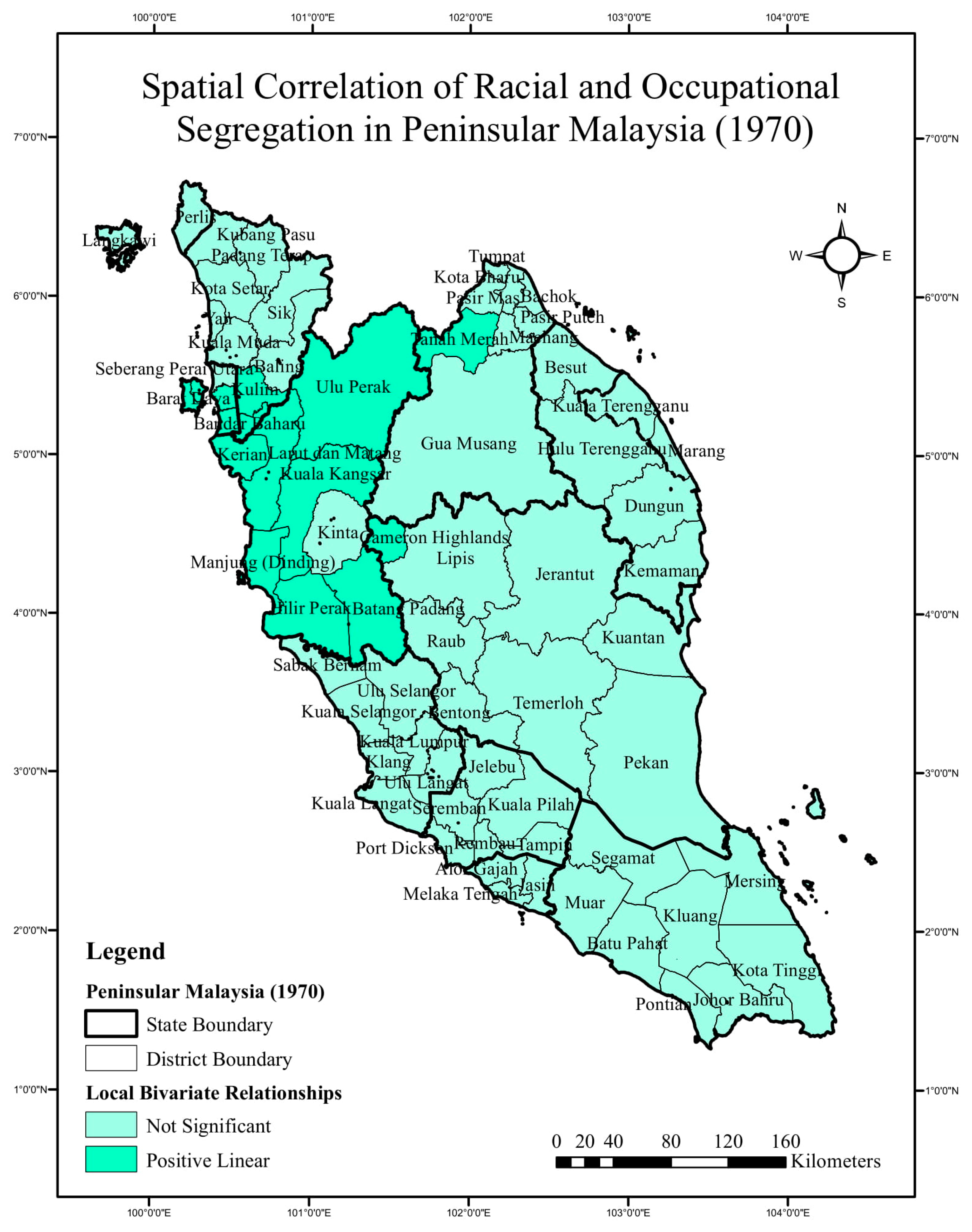
3.1. Spatial Correlation between Racial and Occupational Segregation in Peninsular Malaysia for the 1970 Census

Figure 1 is a choropleth map showing the spatial analysis of Local Bivariate Relationships between racial and occupational segregation based on the 1970 census data. The total number of districts in Peninsular Malaysia for the year 1970 was 70.
Based on the output produced, it was found that 15 out of 70 districts in Peninsular Malaysia exhibited positive linear relationships: Bandar Baharu, Kulim, Tanah Merah, Cameron Highlands, Batang Padang, Hilir Perak, Kerian, Kuala Kangsar, Larut dan Matang, Manjung (Dinding), Ulu Perak, Barat Daya, Seberang Perai Selatan, Seberang Perai Tengah, and Timur Laut.
The positive linear relationships reflect that the Entropy Index (H) of racial segregation increases linearly as the Entropy Index (H) of occupational segregation increases. Adhering to the prime of the Entropy Index (H), the higher the index, the lower the magnitude of segregation. Therefore, both racial and occupational segregation at the listed areas underwent improvement in the context of social separation compared to the other areas.
By consulting the choropleth map, it was discovered that the majority of the areas with positive linear relationships were concentrated in the Northern Region of Peninsular Malaysia, particularly in the districts of Perak. Additionally, a few surrounding and neighboring districts of Pulau Pinang, Kedah, Kelantan, and Pahang also experienced a positive linear relationship. Areas other than those listed above were districts where no significant relationships were found. The term “not significant” means that the relationship between the two variables is not statistically significant.

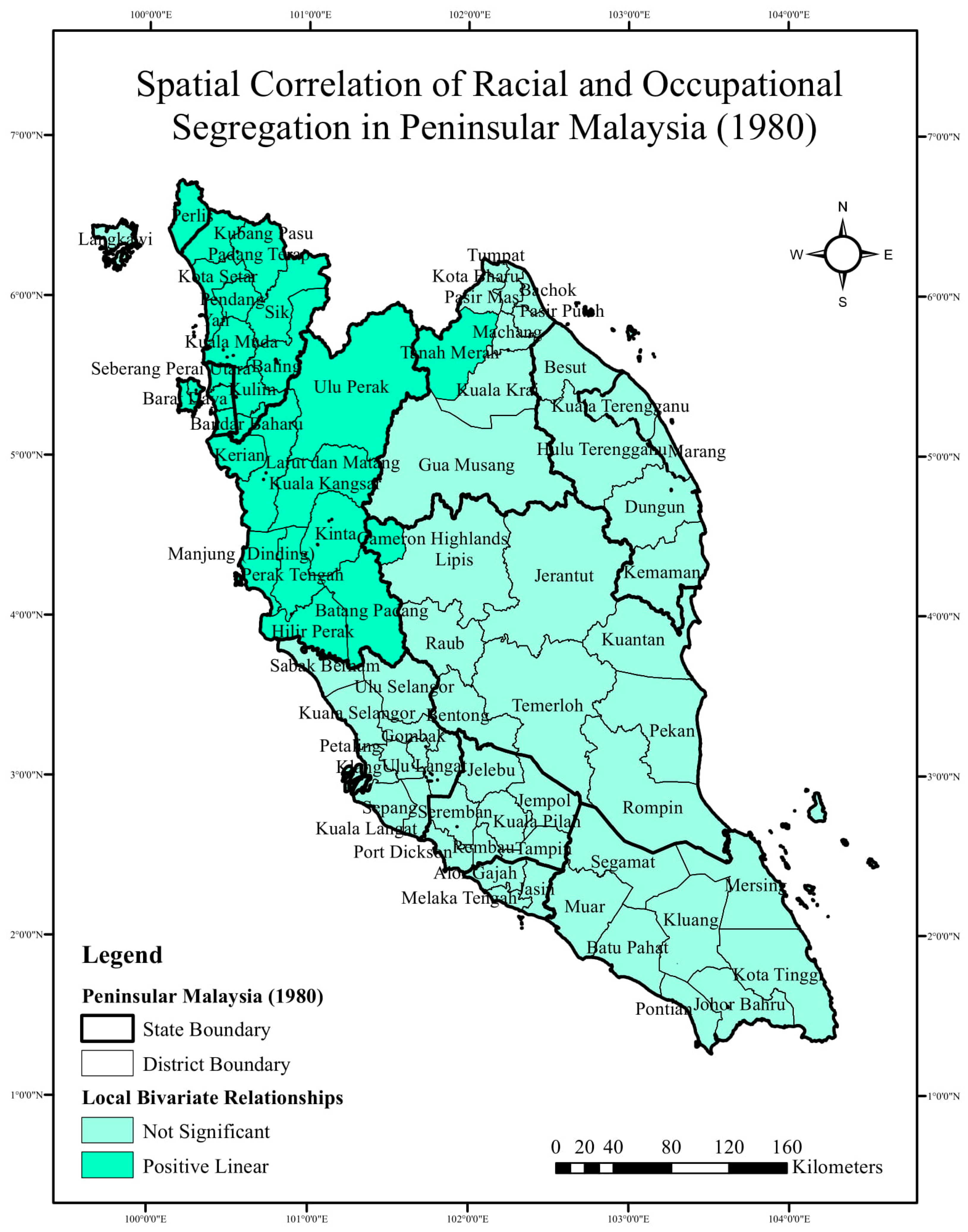
3.2. Spatial Correlation of Racial and Occupational Segregation in Peninsular Malaysia for the 1980 Census

The choropleth map in Figure 2 displays the spatial analysis of Local Bivariate Relationships between racial and occupational segregation based on the 1980 census data. The total number of districts in Peninsular Malaysia for the year 1980 was 78.
The choropleth map visualizes that 27 out of 78 districts in Peninsular Malaysia exhibited positive linear relationships. These districts are Baling, Bandar Baharu, Kota Setar, Kuala Muda, Kubang Pasu, Kulim, Padang Terap, Pendang, Sik, Yan, Tanah Merah, Cameron Highlands, Batang Padang, Hilir Perak, Kerian, Kinta, Kuala Kangsar, Larut dan Matang, Manjung (Dinding), Perak Tengah, Ulu Perak, Perlis, Barat Daya, Seberang Perai Tengah, Seberang Utara, Seberang Perai Selatan, and Timur Laut.
Applying similar interpretation as those used with the previous 1970 results, the positive linear relationships reflect that the Entropy Index (H) of racial segregation increases linearly as the Entropy Index (H) of occupational segregation increases. Following the principal of the Entropy Index (H), the segregation magnitude decreases as the index increases. Hence, both racial and occupational segregation in the districts mentioned above underwent improvement in the context of social separation compared to the other areas.
The geovisulization by the choropleth map revealed that the majority of the areas with positive linear relationship were found concentrated in the Northern Region, mainly covering the districts of Perak, Kedah, and Pulau Pinang, Pahang, Kelantan, and Perlis. When compared to the previous census, it was perceived that the spatial pattern of positive linear expanded and extended to the North of Peninsular Malaysia.
The other 51 districts not mentioned in the explanations above were the areas exhibiting no significant relationships. The term “not significant” means that the relationship between the two variables is not statistically significant.

3.3. Spatial Correlation of Racial and Occupational Segregation in Peninsular Malaysia for the 1991 Census

In 1991, a total of 81 districts of Peninsular Malaysia experienced “not significant” relationships. “Not significant” relationship means that the relationship between the two variables is not statistically significant. When compared to the data from 1970 and 1980, it was observed that there was a great change in the spatial pattern, since the positive linear relationship that was exhibited in the years 1970 and 1980 did not appear in the year 1991.

3.4. Spatial Correlation of Racial and Occupational Segregation in Peninsular Malaysia for the 2000 Census

In 2000, a total of 83 districts of Peninsular Malaysia experienced “not significant” relationships. “Not significant” relationship means that the relationship between the two variables is not statistically significant. When compared to the data from 1970 and 1980, it was observed that there was a great change in the spatial pattern, since the positive linear relationship that was exhibited in the year 1970s and 1980 did not appear in the year 2000.

3.5. Spatial Correlation of Racial and Occupational Segregation in Peninsular Malaysia for the 2010 Census

In 2010, a total of 87 districts of Peninsular Malaysia experienced “not significant” relationships. “Not significant” relationship means that the relationship between the two variables is not statistically significant. When compared to the data from 1970 and 1980, it was observed that there was a great change in the spatial pattern, since the positive linear relationship that was exhibited in the years 1970 and 1980 did not appear in the year 2010.

4. Discussion

By imitating Park’s (1926) [35] famous observation, the significant outcomes proved that spatial patterns reflect social relations. Among the six types of relationships that can be identified by utilizing Local Bivariate Relationships, this study confirmed that there were two types of relationships that appeared between racial and occupational segregation in all districts of Peninsular Malaysia over 50 years, namely, “positive linear relationships” and “not significant” relationships. Positive linear means that the value of the dependent variable increases linearly as the value of the explanatory variable increases; not significant means that the relationship between the variables is not statistically significant.
The dependent variable in this study was the magnitude of racial segregation and the explanatory variable was the magnitude of occupational segregation. However, the variables can be used interchangeably because which variable is labelled as the explanatory variable and which is labelled as the dependent variable has no bearing on whether or not there is a spatial relationship between them.
By applying the constant and standardized number of neighbors of 30, the number of permutations of 199, and the level of confidence of 90%, the results showed that there were positive linear relationships between the two variables in the years 1970, 1980, and 2000. However, the choropleth maps for these three years showed different localities for each census. The areas where positive linear relationships were observed appeared in the Northern Region for the years 1970 and 1980, then disappeared in 1991. The positive linear relationships then re-appeared in 2000, but the localities had shifted to the Southern Region of Peninsular Malaysia.
In the year 1970, the positive linear relationships were found mainly in the Northern Region of Peninsular Malaysia in the districts in Perak, Pulau Pinang, Kedah, Kelantan, and Pahang. The spatial correlation of the positive linear relationship means that when the Entropy Index (H) for occupational segregation increases, the Entropy Index (H) for racial segregation also increases.
However, following the principal of the Entropy Index (H), the segregation magnitude decreases as the value or the index increases. Hence, both racial and occupational segregation in the districts mentioned above underwent less segregation and experienced improvement in the context of social separation compared to the other areas.
In the 1980 census, the positive linear relationship widened and extended towards the Northern Region. In addition to Perak, Pulau Pinang, Kedah, Kelantan, and Pahang, the spatial changes also extended to the state of Perlis. By applying similar interpretations as those used with the results in 1970, the spatial relationship of positive linear relationship means that when the Entropy Index (H) for racial segregation increases, the Entropy Index (H) for occupational segregation also increases. Therefore, the districts showing a positive linear relationship had a low magnitude of racial and occupational segregation compared to the other districts that showed no significant relationships.
The results shown by Figure 1 and Figure 2 portray that the spatial relationships for racial and occupational segregation in the Northern Region in 1970 and 1980 decreased with the implementation of the Gerakan Desa Wawasan (GDW). Therefore, the results show that the two indicators of the SDG of (i) reduced inequalities and (ii) sustainable cities and communities at the above areas in the 1970 and 1980 were found to be both penetrating and positive.
To connect the spatial patterns with the social relationships, Mohd Koharuddin (2005) [36] stated that on the 4 July 1996, a rural development program known as the Gerakan Desa Wawasan (GDW) was initiated at Kampung FELCRA Seberang Perak, Daerah Hilir Perak. The objective of the program was to raise awareness among the locals about rural transformation. A total of 642 villages from all states in Peninsular Malaysia registered in the program. Gerakan Desa Wawasan (1996) [37] was an organized effort to change traditional agricultural to the practice of industrial agriculture. In addition, GDW was also a bottom-up plan used to enhance the ability of the villagers to prepare for entering the year 2020. It was the government’s intention to create rural centers of commerce and industry, hoping that other industries such as agro-based industry and small-scale manufacturers would be stimulated in the rural areas as well, thus leading to more professional employment opportunities in these areas
In relation to the spatial patterns exhibited in 1970 and 1980, it was proven that the GDW succeeded in its goal of shaping the new practice of industrial activities in the Northern Region of Peninsular Malaysia, especially in the districts of Perak. Spatially proven by Figure 1 and Figure 2, the effects of the program had started to take place four years after its implementation in 1970. These proactive signs were radiated through the success of some of the villages that were able to produce and complete a few successful projects using systematic planning. The overrepresentation of Malays in agricultural occupations was slowly reduced, with Malays moving into other sectors.
For example, among the areas that thrived in the program were the development of a modern agricultural economy in Kota Bharu, Kelantan; the optimal development of natural resources in Sik, Kedah; the economic development of agriculture and fisheries in Seberang Perai Tengah, Pulau Pinang; and the development of modern commercial industries in Grik, Perak. The migration to these locations and the involvement of people of different races and occupations had helped to lower the segregation magnitude, initiating the unity of different races and occupations in the places showing positive linear relationships.
For the 1991, 2000, and 2010 censuses, none of the districts of Peninsular Malaysia exhibited positive linear relationships, and all of the districts showed “not significant” relationships. “Not significant” means that no significant spatial and statistical relationships were detected between the dependent variable and the explanatory variable. Among the possibilities that can be assumed when the not significant spatial relationships exist are: (i) when the dependent variable (x) increases, the explanatory variable (y) decreases; (ii) when the dependent variable (x) decreases, the explanatory variable (y) increases, and (iii) when the dependent variable (x) decreases, the explanatory variable (y) decreases.
According to Ibrahim (2011) [38], other than the GDW, the Malaysian Government also implemented regional development programs in the 1970s and 1980s. Regional Development Authorities (RDAs) were established for the implementation of development strategies in newly explored resource areas, mostly in virgin forest areas located in Southeast Pahang, Northeast Johor, South Kelantan, and Central Terengganu. It was observed that most of the RDAs were established in the 1970s, not long after the NEP was launched.
Under the New Economic Policy (NEP) (1970–1990), regional planning and regional development programs were initiated as the strategies for achieving the goals of eradicating poverty and restructuring society socially, economically, and spatially. In other words, the goal was to eliminate the identification of economic activities along ethnic lines.
In detail, Quazi (1987) [39] stated that the objectives of the RDAs were (i) to balance the economic structure between regions (East-West Coast and urban-rural), (ii) to utilize the resource strengths/endowments of less-developed states towards national economic development, (iii) to strengthen and intensify the agricultural and industrial sectors, (iv) to drive new directions of development and growth among the regressed region, (v) and to urbanize the rural agricultural areas.
Several studies which evaluated the implementation of the resource frontier strategy in Malaysia have revealed that the objective of urbanization was not attained. For example, the DARA development master plan suggested the development of 36 new towns, but nine were cancelled due to lack of funds and delays in construction, as well as social and political issues. Additionally, the failure to develop new cities is due to low population numbers.
Wong (1989) [40] opined that the development of Dara and Kesedar did not focus on their targets for irrigating Malay nor for balancing the development between the regions. Choguill (1985) [41] stated that the proposed growth of Ketengah was also a failure, as the development track record lagged as per what had been planned. Among the six new cities, only one city boasted a population of over 10,000 people.
By the 1990s, the government had dissolved the RDAs parallel to the paradigm shift heading towards the role of the private sector in driving growth (privatization policy) [38].
Table 1 and Table 2 show the Entropy Index (H) for each district (feature) and reflects the racial and occupational segregation. When the results of the features are viewed independently, the index shows improvement in the majority of the districts in Peninsular Malaysia for both racial and occupational segregation; however, when applying the Local Bivariate Relationships and taking into account the constant and standardized number of neighbors of 30, the number of permutations of 199, and the level of confidence of 90%, the racial and occupational segregation in Peninsular Malaysia were found to improve only in 1970 and 1980.
To connect the spatial patterns with the social relationships, it is necessary to look at economic factors. Prompted by the worldwide drop in commodities prices in 1985, Malaysia was hit by an economic recession during the second half of 1984 until 1986. As a result, during that period, the non-Malays were not investing in the economy. These economic fluctuations caused short-term alterations in the course of the Fourth and Fifth Malaysia Plans (1986–1990) in relation to the original aims of the NEP; hence, causing the slowing down of economic growth in the early 1980s [42]. The economic recession might also be the causal of termination of the RDAs.
In 1985, the real growth rate fell to minus 1%, marking the climax of the recession. The unemployment rate was high at 6.9%, and this especially affected the Malays by slowing down the creation of their middle class. Due to poor performance in the non-agricultural industries, particularly the electronics industry, many Malays retreated back into agricultural work, consequently ruining the progress achieved under the Fourth Malaysia Plan [20], other words, once again raising the index for occupational segregation. These facts explain the absence of a positive linear relationship for the 1991, 2000, and 2010 censuses, as the economy did not significantly foster racial and occupational integration during this time period. The goals of the NEP were temporarily shelved during the recession of 1985 until 1986 because there was no economic growth. This was a reflection of the flexibility in the implementation of the NEP in response to the changing social and economic pressures of the time.
To reiterate, the NEP was adopted in 1971 for a period of 20 years. According to the Department of Statistics Malaysia (DoSM), the consistent unit of administrative boundaries for the collection of census data in Peninsular Malaysia starting from the year 1970 (based on a 10-year interval census) is at the district level. There are other administrative boundaries that are narrower than those of the districts, such as the sub-district (mukim), village, and census block. However, the data at these units of analysis are not consistently recorded for the 1970, 1980, and 1991 Malaysia Census. These administrative boundaries are only consistent starting from with the year 2000. Besides, data that is more precise than that collected from the district is not publicly available and must be requested.
Therefore, to track the spatial changes that took place in Peninsular Malaysia since the NEP was implemented, the data must be parallel with the period of time when the policy was introduced. In Malaysia, population data at the district level is the data that is published consistently from the 1970 census on. If the study was conducted by applying other units of analysis, the results could only cover the census data available from 2000 on.
Therefore, despite the presence of limitations implicit in terms of methodology, the accuracy of the results is convincing for use by Malaysian authorities because the data used are the most consistent, uniform, earliest, and thorough for all areas in Peninsular Malaysia. Furthermore, the data were collected parallel with the time when the NEP was introduced and implemented.

5. Conclusions

The definitive aim of the NEP was to reduce and eventually eliminate the identification of race with economic function. In detail, it was implemented to overhaul the existing social framework where specific ethnic groups were identified with certain specific occupations as well as to eliminate the economic imbalance between the Malays and other ethnic groups. The goal was to achieve national unity by gradually, over time, creating an ethnically balanced economy which would erase race identification with economic function. Taken from the NEP’s stated goals, racial and occupational segregation were determined as the indicators for this study.
In essence, the long-term spatial changes in racial and occupational segregation play roles as the indicators for measuring and reflecting the sustainable economic development in Peninsular Malaysia from the views of two Sustainable Development Goals, namely reduced inequalities and sustainable cities and communities.
The integration of statistical and spatial analysis has successfully assisted in converting the statistical demographic data into spatial information. In line with that, the comparison of two variables, dependent and explanatory, across a study area to decide whether and how they are related is an essential component of many GIS research workflows. Local Bivariate Relationships analysis was applied to detect the spatial correlation between racial and occupational segregation in Peninsular Malaysia over a 50-year period.
The results revealed that the spatial patterns of racial and occupational segregation reflect the two goals of sustainable development in Peninsular Malaysia. The values of racial and occupational segregation were derived by means of mathematical calculations using the Entropy Index (H), and were both carried and applied in this research objective. The research objective was also met via applying both statistical and spatial analysis.
As a final observation, this research study proves that GIS plays an important role when it comes to dealing with spatial data. Currently, there are no other tools that offer the same capabilities as GIS. Unquestionably, the unique features of GIS are what make it different from the other tools and solutions for analyzing data. Therefore, it has been legitimately proved that GIS is the answer for solving spatial-based problems. To be exact in the context of this research, GIS is worthwhile when integrated with demography, particularly in defining the level achievement of two Sustainable Development Goals, namely reduced inequalities and sustainable cities and communities.

Author Contributions

Conceptualization, N.F.Y. and T.M.; methodology, N.F.Y.; software, N.F.Y., T.M. and A.M.; validation, T.M.; formal analysis, N.F.Y.; investigation, N.F.Y.; resources, N.F.Y.; data curation, N.F.Y.; writing—original draft preparation, N.F.Y.; writing—review and editing, T.M. and R.S.; visualization, N.F.Y. and T.M.; supervision, T.M. and A.M.; project administration, T.M.; funding acquisition, A.M. All authors have read and agreed to the published version of the manuscript.

Funding

The APC was funded by Universiti Malaysia Sarawak (UNIMAS) and research projects JSPS19K01173 & JSPS19H0JSPS.

Institutional Review Board Statement

Not applicable.

Informed Consent Statement

Not applicable.

Data Availability Statement

Data available in a publicly accessible repository. The data presented in this study are openly available in the library of the Department of Statistics Malaysia.

Conflicts of Interest

The authors declare no conflict of interest.

Appendix A

Table A1. The Racial Segregation Index (H) According to Districts in Peninsular Malaysia (1970–2010).
DistrictRacial Segregation Index (H)
19701980199120002010
Batu Pahat0.72230.74291.09750.71960.7165
Johor Bahru1.03060.94991.06110.98070.9760
Kluang1.00560.99961.11580.96070.9428
Kota Tinggi0.82860.60340.71850.49130.5110
Mersing0.71080.69930.66310.45490.4371
Muar0.82760.82400.98510.80190.7856
Pontian0.72640.71701.08960.69030.6781
Segamat0.98660.98051.09590.95130.9223
Kulaijaya----0.9830
Ledang----0.8393
Baling0.71730.63900.56700.43950.3982
Bandar Baharu0.84860.82470.76210.66500.5932
Kota Setar0.76470.75050.72030.66510.6610
Kuala Muda1.06101.00400.96640.91970.8938
Kubang Pasu0.56180.56130.52870.48450.4617
Kulim1.07561.05630.99270.95630.9225
Langkawi0.44060.44280.40480.38040.3178
Padang Terap0.44600.36210.33970.31260.3054
Sik0.42940.37700.32270.29340.2924
Yan0.44260.40720.35960.29920.2571
Pendang-0.55880.49620.43650.4104
Pokok Sena----0.3303
Bachok0.89510.09260.08190.07050.0811
Kota Bharu0.37490.36890.30630.25080.2331
Machang0.25570.24560.19810.16280.1620
Pasir Mas0.22480.19820.15680.12810.1266
Pasir Puteh0.15150.15240.11700.08340.0895
Tanah Merah0.29900.25670.26020.21560.2069
Tumpat0.41830.36440.34820.32440.3267
Gua Musang (Ulu Kelantan)0.45190.48830.33730.26530.2650
Kuala Krai-0.35260.30700.24670.2297
Jeli--0.08670.02180.0371
Alor Gajah0.86290.87190.87550.73940.6951
Jasin0.91710.89950.88720.79150.7282
Melaka Tengah0.92110.90970.91270.86550.8474
Jelebu0.86080.83750.87670.83190.7923
Kuala Pilah0.90730.74210.79680.67490.6522
Port Dickson1.10091.10621.14851.07011.0460
Rembau0.71660.74990.73430.59580.5207
Seremban1.06471.07311.10741.06711.0054
Tampin1.01380.98160.99930.94470.9418
Jempol-1.03920.93680.83750.8463
Bentong0.91650.97201.00680.95940.9328
Cameron Highlands1.09591.07801.08241.03771.0880
Jerantut0.70300.56990.61700.54970.5312
Kuantan0.88200.80560.73950.69090.6251
Lipis0.75780.71530.68430.58280.5162
Pekan0.38140.42920.26620.19220.1888
Raub0.91980.93820.94310.90070.8649
Temerloh0.82640.72680.90550.79480.7547
Rompin-0.40130.37480.23590.2310
Maran--0.37700.26370.2114
Bera---0.82830.8270
Seberang Perai Tengah0.98550.99491.00150.98820.9707
Seberang Perai Utara0.99741.00720.95550.90660.8843
Seberang Perai Selatan1.02541.01421.04291.06701.0632
Timur Laut0.90310.90440.87720.87420.8721
Barat Daya0.84290.85050.89060.86360.8592
Batang Padang1.06251.04411.10350.98980.9184
Manjung (Dinding)0.98951.00431.08121.00160.9751
Kinta0.91240.94231.01991.01701.0215
Kerian0.88050.84611.00310.77360.7301
Kuala Kangsar0.89360.96540.99680.94450.9242
Larut & Matang1.00930.98110.97010.90360.9023
Hilir Perak1.00061.04111.29041.01751.0175
Ulu Perak0.84310.80050.72440.60080.5343
Perak Tengah-0.30000.42840.19940.1607
Kampar----0.9558
Perlis0.65400.65880.57230.50500.4555
Gombak-1.01171.03571.01150.9566
Klang1.09941.06621.20411.07951.0674
Kuala Langat1.05091.03041.33820.99030.9136
Kuala Selangor0.98030.97031.30650.88950.7411
Petaling-1.08471.09001.04431.0000
Sabak Bernam0.68540.74071.15460.71010.6656
Sepang-1.08761.27830.94490.8772
Ulu Langat1.04830.97611.05381.00560.9868
Ulu Selangor1.09441.08511.11251.03170.8393
Besut0.11940.11390.10520.08130.0958
Dungun0.36700.28370.18630.17230.1404
Kemaman0.47250.41510.34800.24130.2154
Kuala Terengganu0.26730.25640.21420.18740.1764
Marang0.07990.09070.14580.10360.1187
Hulu Terengganu0.08730.17270.07550.04590.0439
Setiu--0.04480.03350.0215
Wilayah Persekutuan Kuala Lumpur1.02361.02501.03601.03370.9883
Wilayah Persekutuan Putrajaya----0.1173
Minimum Value0.07990.09070.04480.02180.0215
Maximum Value1.10091.10621.33821.07951.0880
Mean0.75600.72610.73390.63120.6144
Median0.85470.81480.87670.71010.6951
Table A2. The Occupational Segregation Index (H) According to Districts in Peninsular Malaysia (1970–2010).
DistrictOccupational Segregation Index (H)
19701980199120002010
Batu Pahat1.47741.47741.52161.66121.6062
Johor Bahru1.65511.65511.43711.59531.7017
Kluang1.47431.47431.53551.69891.6398
Kota Tinggi1.29541.29541.40491.66241.6586
Mersing1.53411.53411.50281.62671.6214
Muar1.43481.43481.48621.65651.5278
Pontian1.43381.43381.42341.68831.4986
Segamat1.40201.40201.48321.72331.4539
Kulaijaya----1.3606
Ledang----1.3665
Baling0.99790.99791.32101.64871.5233
Bandar Baharu1.24531.24531.40171.63621.5152
Kota Setar1.64561.64561.67161.78041.7878
Kuala Muda1.51641.51641.51661.69251.6683
Kubang Pasu1.06271.06271.49271.66721.6647
Kulim1.40801.40801.42171.61211.5643
Langkawi1.21581.21581.56021.76091.6777
Padang Terap0.89540.89541.16801.43921.4925
Sik0.83550.83551.18621.51201.5634
Yan1.06851.06851.38371.60551.6648
Pendang-0.88791.18171.51971.4970
Pokok Sena----1.5852
Bachok1.12841.12841.37321.54621.6029
Kota Bharu1.64401.64401.64831.72881.5365
Machang1.17611.17611.46761.64981.4657
Pasir Mas1.27881.27881.47671.61491.4318
Pasir Puteh1.17081.17081.46161.56731.4652
Tanah Merah1.12111.12111.41011.58831.5135
Tumpat1.37061.37061.53461.64811.6298
Gua Musang (Ulu Kelantan)1.02671.02671.28741.34081.6051
Kuala Krai-1.19541.29621.47931.6186
Jeli--1.39391.52921.6413
Alor Gajah1.48151.48151.59231.66271.5661
Jasin1.33901.33901.53691.62981.3891
Melaka Tengah1.65121.65121.58711.65761.6174
Jelebu1.22961.22961.35571.53921.5834
Kuala Pilah1.52341.52341.54931.62221.6915
Port Dickson1.51021.51021.62781.53821.6562
Rembau1.39631.39631.52151.58441.6751
Seremban1.70891.70891.56661.57201.7163
Tampin1.38591.38591.45181.57951.5918
Jempol-1.29471.25921.46121.4802
Bentong1.41491.41491.53701.71041.5987
Cameron Highlands1.11351.11351.27181.43011.4041
Jerantut1.28811.28811.44721.56541.5688
Kuantan1.67841.67841.64371.72451.6097
Lipis1.18281.18281.42041.49561.2863
Pekan1.48371.48371.50401.56511.3504
Raub1.48491.48491.43201.57431.1692
Temerloh1.36771.36771.47181.75581.2769
Rompin-1.28851.28331.45641.5086
Maran--1.24291.51961.5873
Bera---1.42111.4492
Seberang Perai Tengah1.52841.52841.44461.59511.5312
Seberang Perai Utara1.55411.55411.45671.68441.5311
Seberang Perai Selatan1.49831.49831.44241.57891.4956
Timur Laut1.57841.57841.47071.65511.6627
Barat Daya1.54251.54251.37681.58201.6283
Batang Padang1.47261.47261.51961.64511.7092
Manjung (Dinding)1.45401.45401.61381.68631.6670
Kinta1.56081.56081.51291.56261.5261
Kerian1.18771.18771.34141.51951.3759
Kuala Kangsar1.40471.40471.48251.57021.4485
Larut Dan Matang1.57281.57281.56921.65021.7069
Hilir Perak1.40321.40321.47351.58511.6581
Ulu Perak1.29051.29051.42521.56121.6819
Perak Tengah-1.16891.36631.58901.6915
Kampar----1.5813
Perlis1.23081.33631.58821.69961.7340
Gombak-1.68991.55541.63421.5552
Klang1.62091.62091.44661.45951.4933
Kuala Langat1.42191.42191.45631.46981.5006
Kuala Selangor1.34591.34591.44271.59601.6118
Petaling-1.70141.53111.56371.5525
Sabak Bernam1.26161.26161.39521.54971.6301
Sepang-1.37971.52161.41341.6614
Ulu Langat1.69691.69691.54711.56141.7009
Ulu Selangor1.45671.45671.53861.51821.6161
Besut1.24561.24561.49931.53911.5468
Dungun1.48101.48101.55801.49381.4774
Kemaman1.45401.45401.54991.53321.4948
Kuala Terengganu1.59201.59201.64911.55931.6754
Marang1.31361.31361.51911.53351.6249
Hulu Terengganu1.20731.20731.37141.47351.6014
Setiu--1.25381.40071.5440
Wilayah Persekutuan Kuala Lumpur1.58291.58291.58251.54921.6651
Wilayah Persekutuan Putrajaya----1.5353
Minimum Value0.83550.83551.16800.00001.1692
Maximum Value1.70891.70891.67161.78041.7878
Mean1.38161.37731.45991.56581.5637
Median1.41141.40401.47181.57951.5834

References

  1. Bongaarts, J. Human Population Growth and the Demographic Transition. Philos. Trans. R. Soc. B Biol. Sci. 2009, 364, 2985–2990. [Google Scholar] [CrossRef] [PubMed] [Green Version]
  2. Ezeh, A.C.; Bongaarts, J.; Mberu, B. Global Population Trends and Policy Options. Lancet 2012, 380, 142–148. [Google Scholar] [CrossRef]
  3. Clarke, J.I. Population Geography and the Developing Countries; Pergamon Press: Oxford, UK; New York, NY, USA, 1971. [Google Scholar]
  4. Ashraf, N.A. Major Determinants of Population Growth. Int. J. Hum. Resour. Ind. Res. (IJHRIR) 2016, 3, 1–7. [Google Scholar]
  5. Waldron, I.; Ricklefs, R.E. Environment and Population: Problems and Solutions; Holt, Rinehart and Winston, Inc.: New York, NY, USA, 1973. [Google Scholar]
  6. Sibly, R.M.; Hone, J. Population Growth Rate and Its Determinants: An Overview. Philos. Trans. R. Soc. B Biol. Sci. 2002, 357, 1153–1170. [Google Scholar] [CrossRef] [PubMed]
  7. Rothenbacher, F. Population Growth and Demographic Transition. In The Central and East European Population since 1850. The Societies of Europe; Palgrave Macmillan: London, UK, 2013. [Google Scholar]
  8. Usman, Y. Prinsip Kajian Kependudukan: Bab 1 Kajian Kependudukan dan Sumber Data; Dewan Bahasa dan Pustaka: Kuala Lumpur, Malaysia, 1989. [Google Scholar]
  9. Norizan, R.; Fariha, R.; Dani, S. Urbanisasi dan Kualiti Hidup: Satu Kajian Literatur Komprehensif. J. Soc. Trans. Reg. Dev. (JSTARD) 2019, 1, 24–32. [Google Scholar]
  10. Bodo, T. Rapid Urbanization: Theories, Causes, Consequences and Coping Strategies. Ann. Geogr. Stud. 2019, 2, 32–45. [Google Scholar]
  11. McGranaham, G.; Satterthwaite, D. Urbanization Concepts and Trends; IIED Working Paper; IIED: London, UK, 2014. [Google Scholar]
  12. Ruslan, R.; Tarmiji, M. Perubahan Corak Ruangan Segregasi Kaum di Negeri Pulau Pinang: 1980–1990. Akademika 2001, 59, 3–32. [Google Scholar]
  13. Siong, H.C. Putrajaya Administrative Centre of Malaysia Planning Concept and Implementation. Sustainable Urban Development and Governance Conference; SungKyunKwan University: Seoul, Korea, 2006. [Google Scholar]
  14. Department of Statistics Malaysia (DoSM). Population Distribution and Basic Demographic Characteristics: Main Findings; Department of Statistics Malaysia: Putrajaya, Malaysia, 2010. [Google Scholar]
  15. Mensah, J. Sustainable development: Meaning, history, principles, pillars, and implications for human action: Literature review. Cogent Soc. Sci. 2019, 5, 1653531. [Google Scholar] [CrossRef]
  16. United Nations. Department of Economic and Social Affairs Population Dynamics: World Population Prospects 2019. 2019. Available online: https://population.un.org/wpp/Maps/ (accessed on 11 January 2021).
  17. Krishnan, P.; Raman, J.H.J. Dasar Pentadbiran British Terhadap Buruh di Tanah Melayu Sebelum Merdeka. 2020. Available online: https://jurcon.ums.edu.my/ojums/index.php/ejk/article/view/2778 (accessed on 11 January 2021).
  18. Mohamed Ali, H.; Ayu Nor Azilah, M. Impak Penjajahan British dan Jepun Terhadap Hubungan Melayu-Cina di Tanah Melayu (The Effects of British and Japanese Occupations towards Chinese-Malay Relationship in Malaya). Jurnal Sultan Alauddin Sulaiman Shah 2017, 4, 94–106. [Google Scholar]
  19. Aszlan, S.; Mohamad Iszuan, S. Penilaian Faktor-faktor Kesenjangan Etnik di Malaysia Sebagai Penghalang Perpaduan Nasional. Jurnal Kinabalu 2016, 19, 77–93. [Google Scholar]
  20. Che Abdul Daim, Z. The Creation and Implementation of the New Economic Policy: Success and Failure, 1970–2008. Ph.D. Thesis, University of Malaya, Kuala Lumpur, Malaysia, 2019. [Google Scholar]
  21. Mohd Faris, D.; Nasir, N.; Kamarul, I. Mengukur Perubahan Segregasi Kaum di Malaysia Menggunakan Indeks Entropi dan Sistem Maklumat Geografi (GIS): Kajian Kes Negeri Perak Bagi Tempoh 1991–2000. Geogr. Online Malays. J. Soc. Space 2016, 12, 12–25. [Google Scholar]
  22. Leete, R. Malaysia’s Demographic Transition: Rapid Development, Culture and Politics, Kuala Lumpur; Oxford University Press: Oxford, UK, 1996. [Google Scholar]
  23. Sidhu, M.S. Kuala Lumpur and Its Population; Surinder Publications: Kuala Lumpur, Malaysia, 1978. [Google Scholar]
  24. Azmi Sharin, A.R. A Critical Assessment the Contribution of the Agriculture Sector in the Growth of the Malaysian Economy. 2014. Available online: https://www.academia.edu/6039505/A_critical_assessment_the_contribution_of_the_agriculture_sector_in_the_growth_of_the_Malaysian_economy_By_Azmi_Shahrin_Bin_Abdul_Rahim (accessed on 11 January 2021).
  25. Shamsul Amri, B. Modul Hubungan Etnik, 2nd ed.; Institut Kajian Etnik Universiti Kebangsaan Malaysia: Kuala Lumpur, Malaysia, 2012. [Google Scholar]
  26. Felke, T.P. Geographic Information Systems: Potential Uses in Social Work Education and Practice. J. Evid.-Based Soc. Work Prac. 2006, 3, 103–113. [Google Scholar] [CrossRef]
  27. Andreev, D.V. The Use of GIS Technology in Modern Conditions. IOP Conf. Ser.: Earth Environ. Sci. 2020, 421, 042001. [Google Scholar] [CrossRef] [Green Version]
  28. Burrough, P.A. Principles Geogr. Information Systems for Land Resour. Assessment; Clarendon Press: Oxford, UK, 1986. [Google Scholar]
  29. Ruslan, R.; Noresah, M.S.; Tarmiji, M. Perubahan konsentrasi ruangan penduduk Semenanjung Malaysia 1980–2000. Geogr. Online Malays. J. Soc. Space 2006, 2, 31–42. [Google Scholar]
  30. Jomo, K.S. Malaysia’s New Economic Policy and National Unity. In Racism and Public Policy; Bangura, Y., Stavenhagen, R., Eds.; Palgrave Macmillan: London, UK, 2005. [Google Scholar]
  31. Anbalakan, K. The New Economic Policy and Further Marginalisation of the Indians. Kajian Malays. 2003, 21, 379–398. [Google Scholar]
  32. Guo, D. Local entropy map: A nonparametric approach to detecting spatially varying multivariate relationships. Int. J. Geogr. Inf. Sci. 2010, 24, 1367–1389. [Google Scholar] [CrossRef]
  33. Daut, D.; Harihodin, S.; Shafry, R. The integration of spatial and non-spatial data model. In Proceedings of the National Conference on Telecommunication Technology 2000, Hyatt Regency Hotel, Johor Bahru, Malaysia, 20–21 November 2000. [Google Scholar]
  34. Mohamed, A.; Asan Ali, G.H. Development Planning and Regional Imbalances in Malaysia. In Proceedings of the 9th International Planning History Conference, Helsinki University of Technology, Helsinki, Finland, 20–23 August 2003. [Google Scholar]
  35. Park, R. The Urban Community as a Spatial Pattern and a Moral Order. In The Urban Community; Burgess, E.W., Ed.; University of Chicago Press: Chicago, IL, USA, 1926. [Google Scholar]
  36. Mohd Koharuddin, M.B. Pembangunan Luar Bandar di Malaysia: Gerakan Desa Wawasan (GDW) Sebagai Mekanisme Pembangunan Masyarakat Luar Bandar. Jurnal Teknologi 2005, 42, 31–48. [Google Scholar]
  37. Gerakan Desa Wawasan. Ke Arah Transformasi Kedua Luar Bandar. In Kementerian Pembangunan Luar Bandar; Institut Kemajuan Desa (INFRA): Bandar Baru Bangi, Malaysia, 1996. [Google Scholar]
  38. Ibrahim, N. Overview of Regional Development in Malaysia. 2011. Available online: https://khairulhkamarudin.files.wordpress.com/2013/04/ibrahim-regional-planning-in-malaysia-website.pdf (accessed on 27 September 2021).
  39. Quazi, A.M.A. Regional Planning in Malaysia: Achievement and Future. In Monograph Faculty of Built Environment; University of Technology Malaysia: Johor Bahru, Malaysia, 1987. [Google Scholar]
  40. Wong, T.C. The Resource Frontier Strategy in Peninsular Malaysia: Case Studies of Pahang Tenggara and KESEDAR Regions. Ph.D. Thesis, The Australian National University, Canberra, Australia, 1989. [Google Scholar]
  41. Choguill, C.L. Small Towns and Development: A Tale from Two Countries. Urban Stud. 1985, 26, 267–274. [Google Scholar] [CrossRef]
  42. Shari, I. Economic growth and income inequality in Malaysia, 1971–1995. J. Asia Pac. Econ. 2000, 5, 112–124. [Google Scholar]
Figure 1. The Spatial Correlation of Racial and Occupational Segregation in Peninsular Malaysia (1970).
Sustainability 14 01490 g001
Figure 2. The Spatial Correlation of Racial and Occupational Segregation in Peninsular Malaysia (1980).
Sustainability 14 01490 g002
Table 1. The classification of the Entropy Index (H) and the Level of Racial Segregation.
Entropy Index (H)Racial Segregation Level
0–0.2773High Segregation
0.2774–0.5545Medium-high Segregation
0.5546–0.8318Medium Segregation
0.8319–1.1090Medium-low Segregation
1.1091–1.3863Low Segregation
Source: Ruslan and Tarmiji (2001).
Table 2. The classification of the Entropy Index (H) and the Level of Occupational Segregation.
Entropy Index (H)Occupational Segregation Level
0–0.3892High Segregation
0.3893–0.7784Medium-high Segregation
0.7785–1.1676Medium Segregation
1.1677–1.5568Medium-low Segregation
1.5569–1.9459Low Segregation
Source: Ruslan and Tarmiji (2001).
Publisher’s Note: MDPI stays neutral with regard to jurisdictional claims in published maps and institutional affiliations.

