
Exploring the Spatial Distribution of Air Pollution and Its Association with Socioeconomic Status Indicators in Mexico City
 , , , , , , ,
 , ,
, ,
Abstract
:1. Introduction
2. Methods
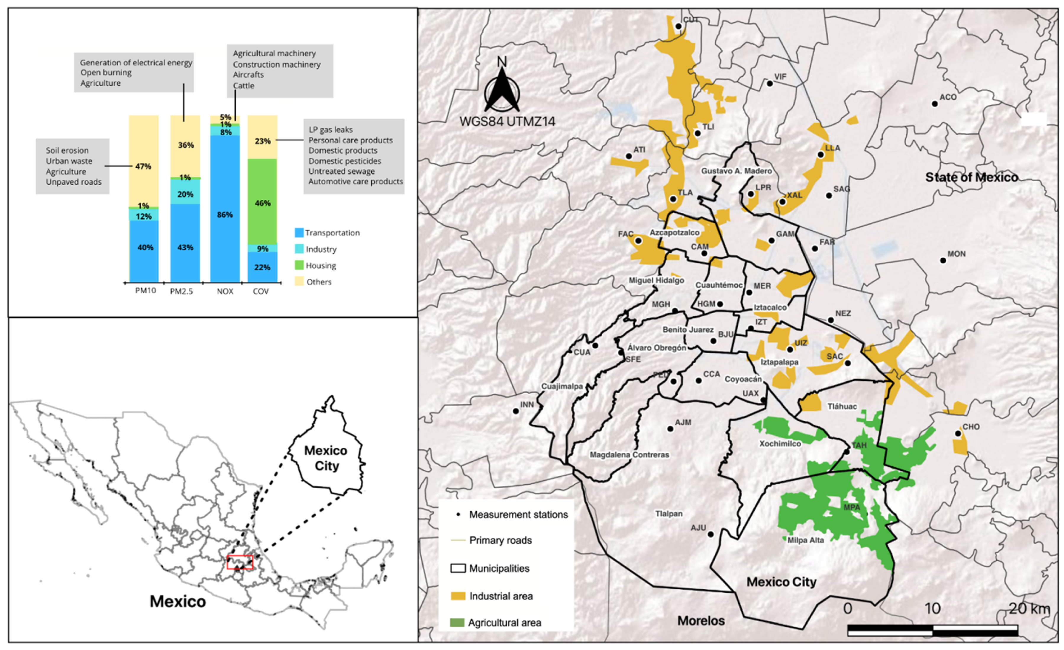
2.1. Study Setting
2.2. Data
Air Pollution and Meteorological Data
2.3. Socioeconomic Status Indicators
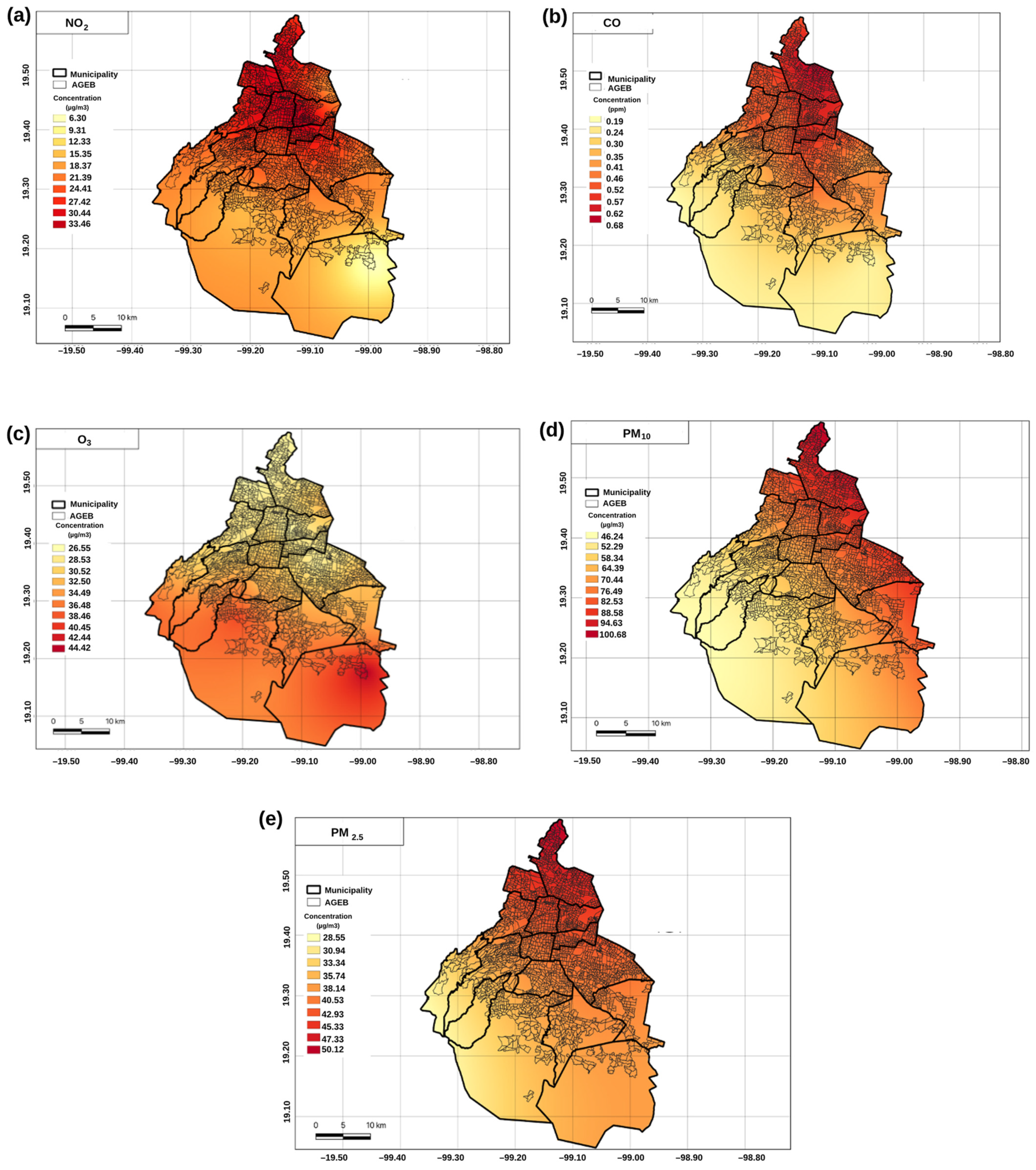
2.4. Spatial Distribution of Air Pollutants
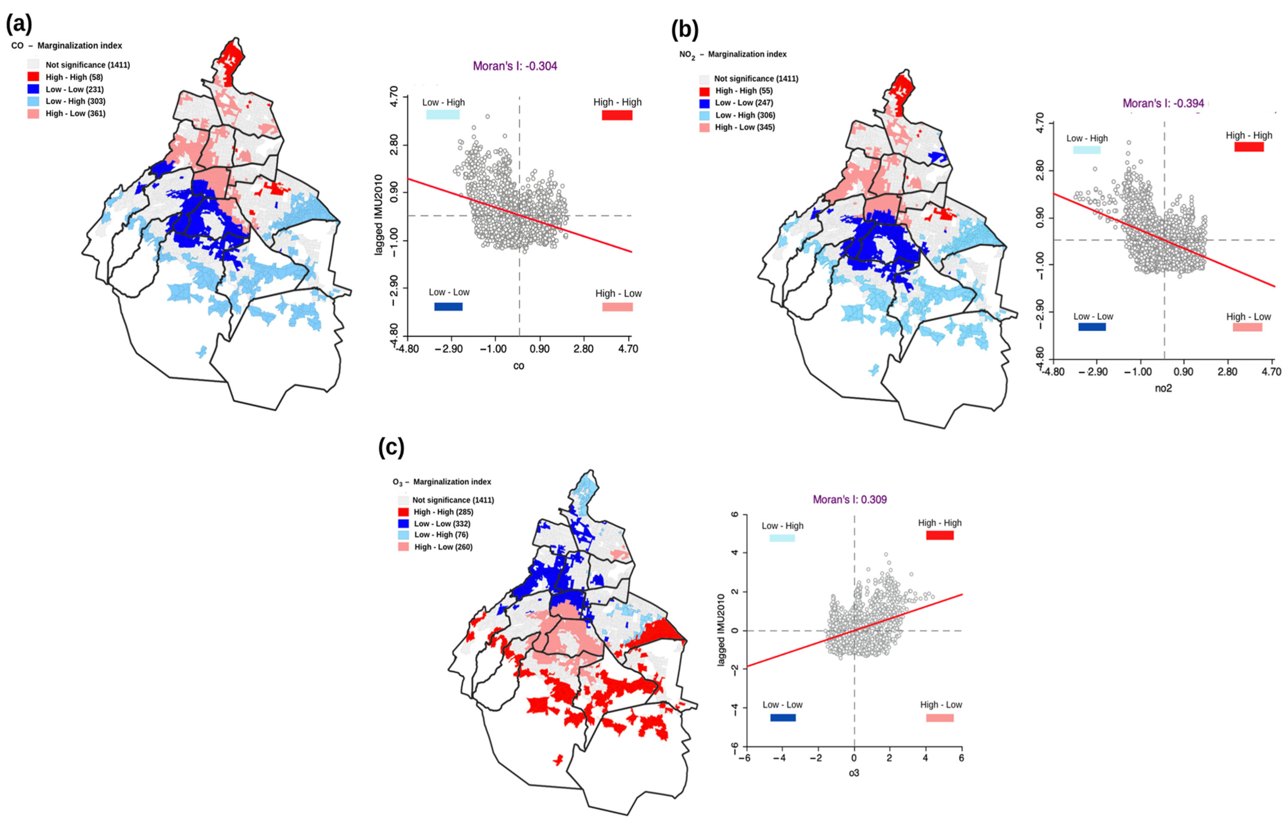
2.5. Spatial Autocorrelations: Bivariate Moran’s I Index
2.6. Seasonal and Meteorological Effects on Air Pollutants’ Concentrations
3. Results
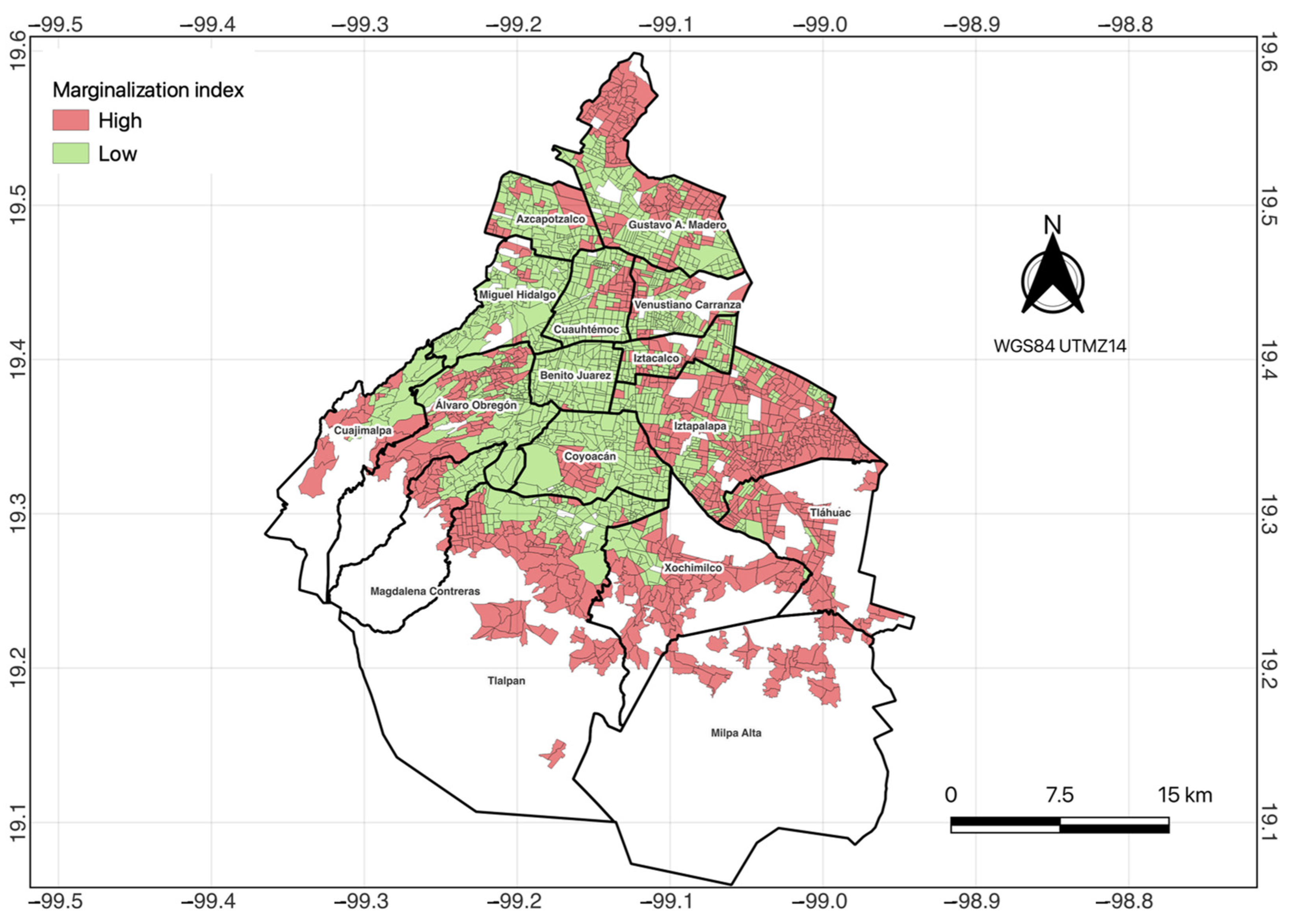
3.1. Spatial Distribution of Air Pollution Exposure in Mexico City
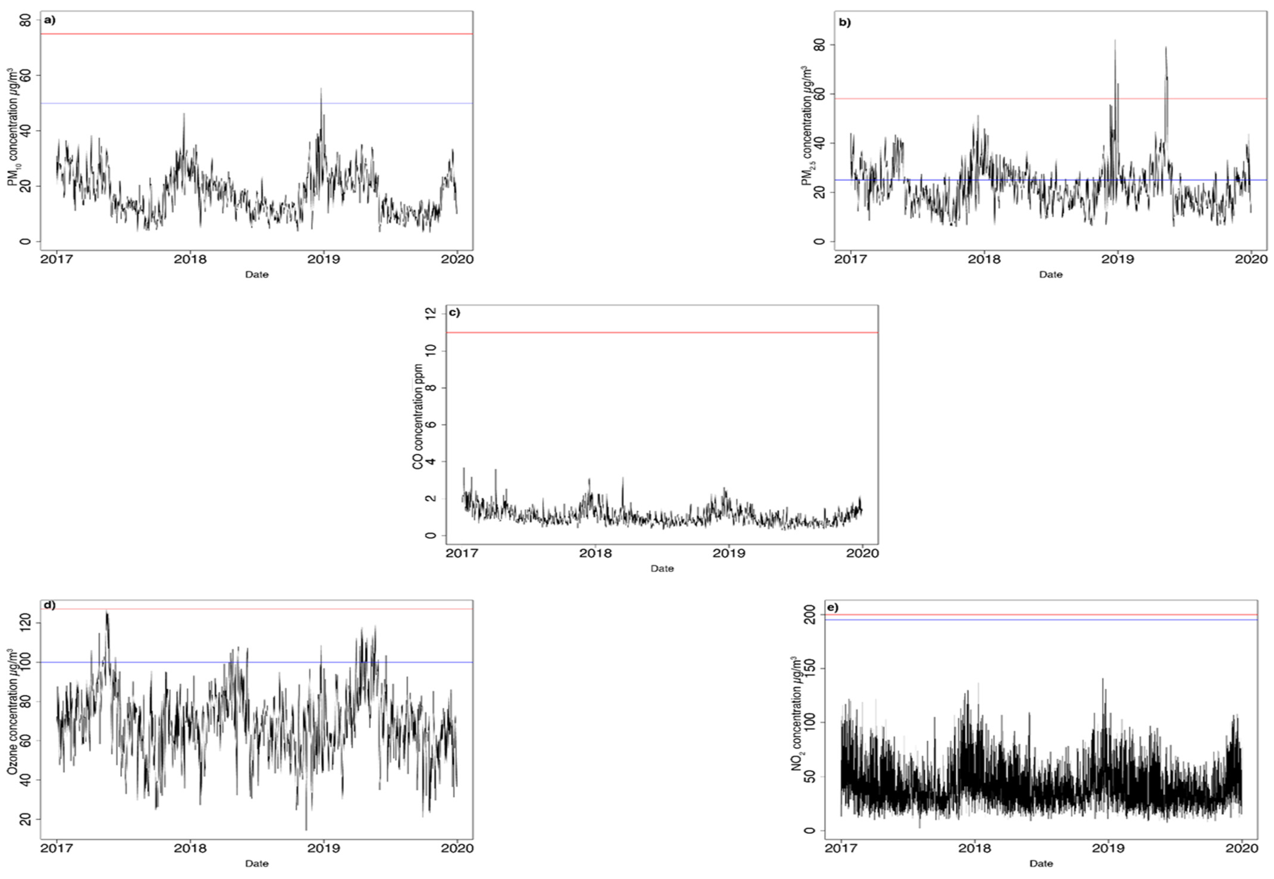
3.2. Seasonal and Meteorological Effects on Air Pollutants’ Concentrations
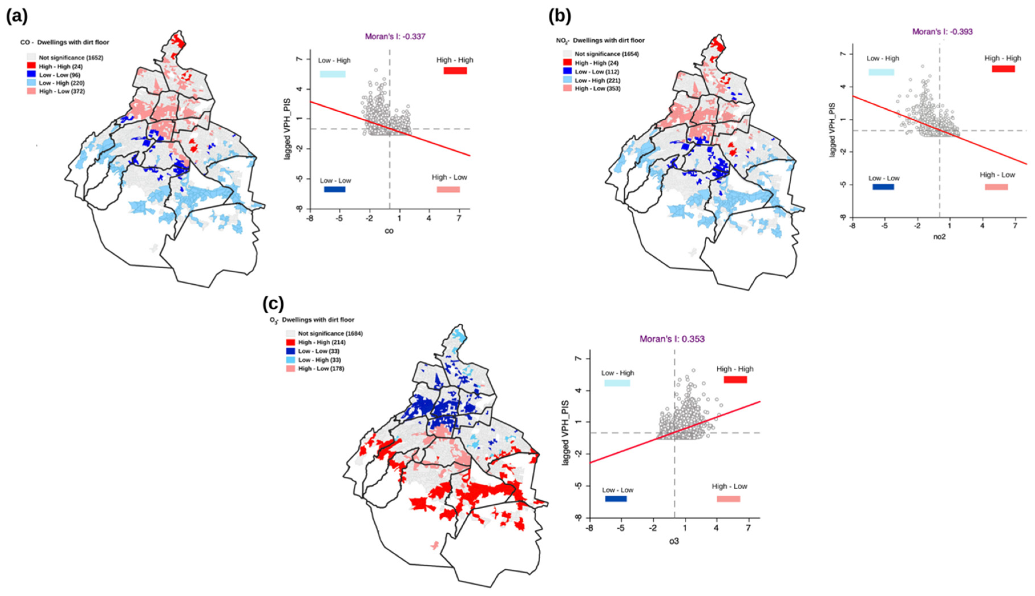
3.3. Spatial Autocorrelation of Air Pollutants and SES Indicators
4. Discussion
4.1. Spatial Distribution of Air Pollutions Exposure in Mexico City
4.2. Spatial Autocorrelations of Air Pollutants and SES Indicators
4.3. Limitations and Future Research
5. Conclusions
Author Contributions
Funding
Informed Consent Statement
Data Availability Statement
Acknowledgments
Conflicts of Interest
Appendix A


| Station | Dry-Cold | Dry-Warm | Wet | ||||||
|---|---|---|---|---|---|---|---|---|---|
| RH Mean ± SD | T °C Mean ± SD | WS Mean ± SD | RH Mean ± SD | T °C Mean ± SD | WS Mean ± SD | Rh Mean ± SD | T °C Mean ± SD | WS Mean ± SD | |
| ACO | 59.9 ± 22 | 17.6 ± 4.6 | 2.4 ± 1.4 | 47.1 ± 22.7 | 18.2 ± 5.6 | 2.6 ± 1.5 | 67.0 ± 18.1 | 17.3 ± 3.8 | 2.3 ± 1.3 |
| AJU | 72.1 ± 21.9 | 11.9 ± 4.2 | 2.5 ± 1.1 | 41.1 ± 18.5 | 17.7 ± 3.9 | 3.2 ± 1.8 | 63.6 ± 16.6 | 16.5 ± 2.9 | 2.6 ± 1.3 |
| AJM | 54.5 ± 20.6 | 17.0 ± 3.4 | 2.8 ± 1.5 | 62.7 ± 24.1 | 11.7 ± 5.5 | 2.9 ± 1.3 | 79.7 ± 16.5 | 12.0 ± 3.4 | 2.2 ± 1.0 |
| BJU | 54.0 ± 20.8 | 18.8 ± 3.8 | 1.8 ± 0.9 | 42.1 ± 19.6 | 19.5 ± 4.5 | 1.9 ± 1.0 | 61.3 ± 18.0 | 18.4 ± 3.3 | 1.8 ± 0.8 |
| CHO | 58.7 ± 20.6 | 17.7 ± 4.3 | 1.7 ± 1.1 | 45.6 ± 19.6 | 18.3 ± 5.2 | 1.8 ± 1.2 | 67.6 ± 16.0 | 17.2 ± 3.6 | 1.6 ± 1.1 |
| CUA | 59.3 ± 21.3 | 15.2 ± 3.6 | 2.0 ± 0.9 | 44.4 ± 19.3 | 16.3 ± 4.0 | 2.2 ± 1.0 | 68.8 ± 16.6 | 14.6 ± 3.1 | 1.9 ± 0.9 |
| CUT | 65.0 ± 24.2 | 16.8 ± 5.2 | 1.6 ± 0.9 | 52.8 ± 26.8 | 16.8 ± 7.0 | 1.7 ± 1.0 | 71.6 ± 19.8 | 16.8 ± 4.2 | 1.6 ± 0.8 |
| FAC | 55.6 ± 24.0 | 18.5 ± 5.7 | 1.8 ± 0.9 | 43.0 ± 22.9 | 19.1 ± 6.8 | 1.9 ± 1.0 | 63.5 ± 21.1 | 18.2 ± 4.9 | 1.8 ± 0.9 |
| GAM | 58.5 ± 21.0 | 19.2 ± 4.0 | 2.0 ± 1.3 | 46.1 ± 20.1 | 20.0 ± 4.7 | 2.1 ± 1.3 | 66.1 ± 17.8 | 18.8 ± 3.4 | 2.0 ± 1.2 |
| HGM | 51.1 ± 19.4 | 18.9 ± 3.7 | 1.9 ± 1.1 | 37.8 ± 17.9 | 19.9 ± 4.3 | 1.9 ± 1.2 | 57.4 ± 16.8 | 18.4 ± 3.3 | 1.9 ± 1.0 |
| INN | 69.0 ± 22.5 | 11.5 ± 5.5 | 1.6 ± 0.9 | 57.4 ± 23.3 | 11.4 ± 5.9 | 1.8 ± 1.1 | 79.1 ± 16.2 | 11.8 ± 3.7 | 1.4 ± 0.8 |
| LAA | 58.5 ± 23.4 | 18.2 ± 4.3 | 1.9 ± 0.9 | 44.2 ± 21.5 | 19.1 ± 5.1 | 1.9 ± 1.0 | 67.0 ± 20.1 | 17.8 ± 3.7 | 1.9 ± 0.9 |
| MER | 54.8 ± 20.9 | 18.8 ± 3.8 | 2.2 ± 1.0 | 42.1 ± 19.9 | 19.7 ± 4.5 | 2.2 ± 1.2 | 62.4 ± 17.6 | 18.3 ± 3.3 | 2.2 ± 1.0 |
| MGH | 50.8 ± 21.4 | 18.8 ± 3.9 | 2.1 ± 1.0 | 37.0 ± 19.2 | 19.8 ± 4.5 | 2.2 ± 1.1 | 59.2 ± 18.1 | 18.2 ± 3.3 | 2.0 ± 0.9 |
| MON | 59.1 ± 22.1 | 18.3 ± 5.0 | 2.2 ± 1.5 | 46.4 ± 21.9 | 18.9 ± 6.1 | 2.4 ± 1.6 | 67.3 ± 18.0 | 18.0 ± 4.2 | 2.0 ± 1.5 |
| MPA | 59.0 ± 20.1 | 16.2 ± 3.8 | 2.8 ± 1.3 | 44.2 ± 19.2 | 17.7 ± 4.4 | 3.3 ± 1.6 | 67.8 ± 14.8 | 15.3 ± 3.1 | 2.5 ± 1.1 |
| NEZ | 54.0 ± 19.8 | 17.8 ± 3.9 | 2.5 ± 1.3 | 42.1 ± 19.1 | 18.7 ± 4.6 | 2.6 ± 1.5 | 61.4 ± 16.3 | 17.2 ± 3.3 | 2.5 ± 1.3 |
| PED | 56.0 ± 21.3 | 18.1 ± 3.9 | 1.9 ± 0.9 | 42.4 ± 19.2 | 19.1 ± 4.5 | 2.2 ± 1.1 | 64.3 ± 17.9 | 17.6 ± 3.3 | 1.9 ± 0.8 |
| SAG | 48.3 ± 21.7 | 19.6 ± 4.1 | 1.6 ± 0.8 | 37.2 ± 20.1 | 20.3 ± 4.8 | 1.5 ± 0.8 | 56.3 ± 19.2 | 19.2 ± 3.5 | 1.6 ± 0.9 |
| SFE | 58.7 ± 21.8 | 16.0 ± 3.6 | 2.3 ± 1.0 | 43.8 ± 19.4 | 17.1 ± 4.3 | 2.7 ± 1.0 | 69.1 ± 16.7 | 15.4 ± 3.0 | 2.2 ± 0.9 |
| TAH | 54.5 ± 20.2 | 18.0 ± 4.2 | 2.1 ± 1.1 | 39.9 ± 19.4 | 19.0 ± 5.1 | 2.3 ± 1.4 | 61.4 ± 16.7 | 17.6 ± 3.6 | 2.0 ± 1.0 |
| TLA | 52.0 ± 19.9 | 18.0 ± 4.0 | 2.1 ± 1.1 | 39.7 ± 19.1 | 18.7 ± 4.8 | 2.1 ± 1.2 | 59.3 ± 16.5 | 17.6 ± 3.4 | 2.2 ± 1.1 |
| UAX | 55.6 ± 20.7 | 18.5 ± 4.1 | 2.0 ± 1.0 | 44.6 ± 20.0 | 19.0 ± 4.8 | 2.2 ± 1.2 | 62.9 ± 17.7 | 18.1 ± 3.5 | 1.9 ± 0.9 |
| UIZ | 56.7 ± 21.5 | 19.2 ± 3.7 | 2.2 ± 1.1 | 44.7 ± 20.7 | 20.2 ± 4.6 | 2.3 ± 1.3 | 64.0 ± 18.5 | 18.9 ± 3.5 | 2.2 ± 1.1 |
| VIF | 56.9 ± 22.6 | 18.5 ± 4.5 | 2.0 ± 1.1 | 44.7 ± 22.4 | 19.2 ± 5.4 | 2.0 ± 1.2 | 64.2 ± 19.4 | 18.0 ± 3.7 | 2.0 ± 1.1 |
| XAL | 51.3 ± 18.9 | 18.2 ± 3.6 | 2.9 ± 2.0 | 39.3 ± 18.3 | 19.0 ± 4.3 | 2.8 ± 2.1 | 57.7 ± 15.8 | 17.9 ± 3.1 | 2.9 ± 2.0 |
| Average | 57.0 | 17.5 | 2.1 | 42.9 | 18.2 | 2.3 | 65.1 | 17.1 | 2.1 |
| IMU2010 | POBTOT | POBFEM | POBMAS | P_0A20 | P_3A5 | P_60YMAS | PHOG_IND | PCON_DISC | PSINDER | VPH_ PISOTI | VPH_S_ELEC | VPH_AGUAFV | VPH_NODRAIN | VPH_NDA CMM | VPH_SIN TIC | |
|---|---|---|---|---|---|---|---|---|---|---|---|---|---|---|---|---|
| IMU2010 | 1 | 0.3 | 0.3 | 0.4 | 0.5 | 0.5 | 0.0 | 0.6 | 0.4 | 0.5 | 0.6 | 0.4 | 0.4 | 0.4 | 0.4 | 0.5 |
| POBTOT | 0.3 | 1 | 1 | 1 | 0.9 | 0.9 | 0.8 | 0.7 | 0.8 | 0.9 | 0.4 | 0.3 | 0.2 | 0.3 | 0.9 | 0.5 |
| POBFEM | 0.3 | 1 | 1 | 1 | 0.9 | 0.9 | 0.8 | 0.7 | 0.8 | 0.9 | 0.4 | 0.3 | 0.2 | 0.3 | 0.9 | 0.5 |
| POBMAS | 0.4 | 1 | 1 | 1 | 0.9 | 0.9 | 0.8 | 0.7 | 0.8 | 0.9 | 0.4 | 0.3 | 0.2 | 0.3 | 0.9 | 0.6 |
| P_0A20 | 0.5 | 0.9 | 0.9 | 0.9 | 1 | 0.9 | 0.7 | 0.7 | 0.8 | 0.9 | 0.5 | 0.4 | 0.3 | 0.4 | 0.8 | 0.6 |
| P_3A5 | 0.5 | 0.9 | 0.9 | 0.9 | 0.9 | 1 | 0.7 | 0.7 | 0.8 | 0.9 | 0.5 | 0.4 | 0.3 | 0.4 | 0.9 | 0.6 |
| P_60YMAS | 0.0 | 0.8 | 0.8 | 0.8 | 0.7 | 0.7 | 1 | 0.3 | 0.7 | 0.7 | 0.1 | 0.1 | 0.0 | 0.1 | 0.7 | 0.3 |
| PHOG_IND | 0.6 | 0.7 | 0.7 | 0.7 | 0.7 | 0.7 | 0.3 | 1 | 0.6 | 0.7 | 0.6 | 0.5 | 0.5 | 0.6 | 0.6 | 0.6 |
| PCON_DISC | 0.4 | 0.8 | 0.8 | 0.8 | 0.8 | 0.8 | 0.7 | 0.6 | 1 | 0.8 | 0.4 | 0.3 | 0.2 | 0.3 | 0.8 | 0.5 |
| PSINDER | 0.5 | 0.9 | 0.9 | 0.9 | 0.9 | 0.9 | 0.7 | 0.7 | 0.8 | 1 | 0.5 | 0.4 | 0.2 | 0.3 | 0.9 | 0.6 |
| VPH_PISOTI | 0.6 | 0.4 | 0.4 | 0.4 | 0.5 | 0.5 | 0.1 | 0.6 | 0.4 | 0.5 | 1 | 0.6 | 0.5 | 0.6 | 0.4 | 0.5 |
| VPH_S_ELEC | 0.4 | 0.3 | 0.3 | 0.3 | 0.4 | 0.4 | 0.1 | 0.5 | 0.3 | 0.4 | 0.6 | 1 | 0.4 | 0.6 | 0.3 | 0.5 |
| VPH_AGUAFV | 0.4 | 0.2 | 0.2 | 0.2 | 0.3 | 0.3 | 0.0 | 0.5 | 0.2 | 0.2 | 0.5 | 0.4 | 1 | 0.6 | 0.2 | 0.3 |
| VPH_NODRAIN | 0.4 | 0.3 | 0.3 | 0.3 | 0.4 | 0.4 | 0.1 | 0.6 | 0.3 | 0.3 | 0.6 | 0.6 | 0.6 | 1 | 0.3 | 0.4 |
| VPH_NDACMM | 0.4 | 0.9 | 0.9 | 0.9 | 0.8 | 0.9 | 0.7 | 0.7 | 0.8 | 0.9 | 0.4 | 0.3 | 0.2 | 0.3 | 1 | 0.6 |
| VPH_SINTIC | 0.5 | 0.5 | 0.5 | 0.6 | 0.6 | 0.6 | 0.3 | 0.6 | 0.5 | 0.6 | 0.5 | 0.5 | 0.3 | 0.4 | 0.6 | 1 |
| Estimate | Pollutant | ||||
|---|---|---|---|---|---|
| PM2.5 | PM10 | O3 | CO | NO2 | |
| Nugget | 5.3 | 134.4 | 0 | 0 | 0 |
| Psill | 254.6 | 1297.6 | 18.5 | 0.01 | 30.1 |
| Range | 59.9 | 10.8 | 21.4 | 26.4 | 4.2 |
| Model | Gaussian | Materon | Materon | Lineal | Materon |
Appendix B
| SES Indicator | Description |
|---|---|
| POBTOT | Total population |
| POPMAS | Total male population |
| POP_FEM | Total female population |
| P_HOG_IND | Population who declared speaking an indigenous language or considered themselves as indigenous |
| POBAFRO | Population who considers themselves Afro-Mexican or Afro-descendant |
| PCON_DIS | Population with disabilities that perform with great difficulties |
| P_60YMAS | Population aging 60 to 130 years |
| P_0A2 and P_3A5 | Population younger than 5 years old. |
| PSINDER | Population without access to health services |
| VPH_PISOTI | Number of houses with dirt floors. |
| VPH_S_ELEC | Number of houses without electricity. |
| VPH_NODRAIN | Number of houses without drainage connection |
| VPH_AGUAFV | Number of houses without access to potable water |
| VPH_NDACMM | Number of houses lacking access to private motorized transport |
| VPH_SINTIC | Number of houses without technology |
| IMU2010 | Compound index built on different inequality dimensions such as access to education and health care, availability of first-order goods, of and enjoyment of adequate housing rights |
- 1.
- Spatial Distribution of Air Pollutants
- 2.
- Spatial Autocorrelation Index
References
- IPCC Summary for Policymakers. Climate Change 2022: Impacts, Adaptation and Vulnerability. Contribution of Working Group II to the Sixth Assessment Report of the Intergovernmental Panel on Climate; Pörtner, H.-O., Roberts, D.C., Poloczanska, E.S., Mintenbeck, K., Tignor, M., Alegría, A., Craig, M., Langsdorf, S., Löschke, S., Möller, V., et al., Eds.; Cambridge University Press: Cambridge, UK; New York, NY, USA, 2022; pp. 3–33. [Google Scholar] [CrossRef]
- Xiao, X.; Gao, M. Overview of climate change, air pollution, and human health. In Air Pollution, Climate, and Health: An Integrated Perspective on Their Interactions; Gao, M., Wang, Z.F., Carmichael, G., Eds.; Elsevier: Amsterdam, The Netherlands, 2021; Volume 12, pp. 3–12. [Google Scholar] [CrossRef]
- Kelly, F.J.; Fussell, J.C. Air Pollution and Public Health: Emerging Hazards and Improved Understanding of Risk. Environ. Geochem. Health 2015, 37, 631–649. [Google Scholar] [CrossRef] [PubMed] [Green Version]
- World Health Organization (WHO). Environmental Health Inequalities in Europe: Assessment Report. 2012. Available online: https://apps.who.int/iris/bitstream/handle/10665/107299/e96194.pdf?sequence=1 (accessed on 12 July 2022).
- Environmental Protection Agency (EPA). Air Quality Criteria for Particulate Matter (Final Report, 1996). Risk Assessment Portal. US EPA. 1996. Available online: https://cfpub.epa.gov/ncea/risk/recordisplay.cfm?deid=2832 (accessed on 12 July 2022).
- Islam, S.N.; Winkel, J. Climate Change and Social Inequality. DESA Working Paper 152. Department of Economic & Social Affairs, United Nations. 2017. Available online: https://www.un.org/development/desa/publications/working-paper/wp152 (accessed on 12 July 2022).
- Wenz, P.S. Environmental Justice; State University of New York Press: Albany, NY, USA, 1988; Available online: https://sunypress.edu/Books/E/Environmental-Justice (accessed on 12 July 2022).
- Chakraborty, J.; Basu, P. Linking Industrial Hazards and Social Inequalities: Environmental Injustice in Gujarat, India. Int. J. Environ. Res. Public Health 2018, 16, 42. [Google Scholar] [CrossRef] [PubMed] [Green Version]
- Ferguson, L.; Taylor, J.; Davies, M.; Shrubsole, C.; Symonds, P.; Dimitroulopoulou, S. Exposure to Indoor Air Pollution across Socio-Economic Groups in High-Income Countries: A Scoping Review of the Literature and a Modelling Methodology. Environ. Int. 2020, 143, 105748. [Google Scholar] [CrossRef] [PubMed]
- Hajat, A.; Hsia, C.; O’Neill, M.S. Socioeconomic Disparities and Air Pollution Exposure: A Global Review. Curr. Environ. Health Rep. 2015, 2, 440–450. [Google Scholar] [CrossRef] [PubMed] [Green Version]
- Harper, S.; Ruder, E.; Roman, H.; Geggel, A.; Nweke, O.; Payne-Sturges, D.; Levy, J. Using Inequality Measures to Incorporate Environmental Justice into Regulatory Analyses. Int. J. Environ. Res. Public Health 2013, 10, 4039–4059. [Google Scholar] [CrossRef] [Green Version]
- Chakraborti, L.; Shimshack, J.P. Environmental Disparities in Urban Mexico: Evidence from Toxic Water Pollution. Resour. Energy Econ. 2022, 67, 101281. [Google Scholar] [CrossRef]
- Eakin, H.; Parajuli, J.; Yogya, Y.; Hernández, B.; Manheim, M. Entry Points for Addressing Justice and Politics in Urban Flood Adaptation Decision Making. Curr. Opin. Environ. Sustain. 2021, 51, 1–6. [Google Scholar] [CrossRef]
- Reed, P.M.; Hadjimichael, A.; Moss, R.H.; Brelsford, C.; Burleyson, C.D.; Cohen, S.; Dyreson, A.; Gold, D.F.; Gupta, R.S.; Keller, K.; et al. Multisector Dynamics: Advancing the Science of Complex Adaptive Human-Earth Systems. Earths Future 2022, 10, 1–18. [Google Scholar] [CrossRef]
- Eakin, H.; Bojórquez-Tapia, L.A.; Janssen, M.; Georgescu, M.; Manuel-Navarrete, D.; Vivoni, E.R.; Escalante, A.E.; Baeza-Castro, A.; Mazari-Hiriart, M.; Lerner, A.M. Urban resilience efforts must consider social and political forces. Proc. Natl. Acad. Sci. USA 2017, 114, 186–189. [Google Scholar] [CrossRef] [Green Version]
- Li, M.; Du, W. Can internet development improve energy efficiency of firms: Empirical evidence from China. Energy 2021, 237, 121590. [Google Scholar] [CrossRef]
- Doss-Gollin, J.; Farnham, D.J.; Steinschneider, S.; Lall, U. Robust Adaptation to Multiscale Climate Variability. Earths Future 2019, 7, 734–747. [Google Scholar] [CrossRef] [Green Version]
- Namdeo, A.; Stringer, C. Investigating the relationship between air pollution, health and social deprivation in Leeds, UK. Environ. Int. 2008, 34, 585–591. [Google Scholar] [CrossRef] [PubMed]
- Flanagan, E.; Mattisson, K.; Walles, J.; Abera, A.; Eriksson, A.; Balidemaj, F.; Oudin, A.; Isaxon, C.; Malmqvist, E. Air Pollution and Urban Green Space: Evidence of Environmental Injustice in Adama, Ethiopia. Front. Sustain. Cities 2021, 3, 728384. [Google Scholar] [CrossRef]
- Marshall, J.D. Environmental Inequality: Air Pollution Exposures in California’s South Coast Air Basin. Atmos. Environ. 2008, 42, 5499–5503. [Google Scholar] [CrossRef]
- Morello-Frosch, R.; Pastor, M.; Porras, C.; Sadd, J. Environmental Justice and Regional Inequality in Southern California: Implications for Future Research. Environ. Health Perspect. 2002, 110, 149–154. [Google Scholar] [CrossRef] [Green Version]
- Barnes, J.H.; Chatterton, T.J.; Longhurst, J.W.S. Emissions vs Exposure: Increasing Injustice from Road Traffic-Related Air Pollution in the United Kingdom. Transp. Res. Part D Transp. Environ. 2019, 73, 56–66. [Google Scholar] [CrossRef]
- Samoli, E.; Stergiopoulou, A.; Santana, P.; Rodopoulou, S.; Mitsakou, C.; Dimitroulopoulou, C.; Bauwelinck, M.; de Hoogh, K.; Costa, C.; Marí-Dell’Olmo, M.; et al. Spatial Variability in Air Pollution Exposure in Relation to Socioeconomic Indicators in Nine European Metropolitan Areas: A Study on Environmental Inequality. Environ. Pollut. 2019, 249, 345–353. [Google Scholar] [CrossRef]
- Lomé-Hurtado, A.; Touza-Montero, J.; White, P.C.L. Environmental Injustice in Mexico City: A Spatial Quantile Approach. Expo. Health 2020, 12, 265–279. [Google Scholar] [CrossRef]
- Instituto Nacional de Estadística, Geografía e Informática (INEGI). Censo de Población y Vivienda. 2020. Available online: https://www.inegi.org.mx/programas/ccpv/2020/ (accessed on 13 July 2022).
- López Vázquez, V.H.; Plata Rocha, W. Análisis de Los Cambios de Cobertura de Suelo Derivados de La Expansión Urbana de La Zona Metropolitana de La Ciudad de México, 1990–2000. Investig. Geográficas 2009, 68, 85–101. [Google Scholar]
- Romero Lankao, P. Water in Mexico City: What Will Climate Change Bring to Its History of Water-Related Hazards and Vulnerabilities? Environ. Urban. 2010, 22, 157–178. [Google Scholar] [CrossRef] [Green Version]
- Secretaría del Medio Ambiente de la Ciudad de México (SEDEMA). Informe de Calidad Del Aire En La Ciudad de México. 2016. Available online: http://www.aire.cdmx.gob.mx/descargas/publicaciones/flippingbook/informe-2016-calidad-del-aire-en-la-ciudad-de-mexico/mobile/index.html (accessed on 12 July 2022).
- Instituto Nacional de Estadística, Geografía e Informática-Directorio Estadístico Nacional de Unidades Económicas (INEGI-DNUE). Directorio de Empresas y Establecimientos. 2022. Available online: https://www.inegi.org.mx/temas/directorio/ (accessed on 12 July 2022).
- Bell, M.L.; Davis, D.L.; Gouveia, N.; Borja-Aburto, V.H.; Cifuentes, L.A. The Avoidable Health Effects of Air Pollution in Three Latin American Cities: Santiago, São Paulo, and Mexico City. Environ. Res. 2006, 100, 431–440. [Google Scholar] [CrossRef] [PubMed]
- Vega, E.; Namdeo, A.; Bramwell, L.; Miquelajauregui, Y.; Resendiz-Martinez, C.G.; Jaimes-Palomera, M.; Luna-Falfan, F.; Terrazas-Ahumada, A.; Maji, K.J.; Entwistle, J.; et al. Changes in Air Quality in Mexico City, London and Delhi in Response to Various Stages and Levels of Lockdowns and Easing of Restrictions during COVID-19 Pandemic. Environ. Pollut. 2021, 285, 117664. [Google Scholar] [CrossRef] [PubMed]
- Mamkhezri, J.; Bohara, A.K.; Islas Camargo, A. Air Pollution and Daily Mortality in the Mexico City Metropolitan Area. Atmósfera 2020, 33, 249–267. [Google Scholar] [CrossRef]
- Consejo Nacional de Población (CONAPO). Índices de Marginación 2010. Consejo Nacional de Población. 2010. Available online: https://www.gob.mx/conapo/documentos/indices-de-marginacion-2020-284372 (accessed on 13 July 2022).
- Wu, Y.-H.; Hung, M.-C. Comparison of Spatial Interpolation Techniques Using Visualization and Quantitative Assessment. In Applications of Spatial Statistics; IntechOpen: Oxford, UK, 2016. [Google Scholar]
- Armstrong, M. Basic Linear Geostatistics; Springer: Berlin, Germany, 1998. [Google Scholar]
- Deligiorgi, D.; Philippopoulos, K. Spatial interpolation methodologies in urban air pollution modeling: Application for the greater area of metropolitan Athens, Greece. Adv. Air Pollut. 2011, 17, 10. [Google Scholar]
- Willmott, C.J. Some Comments on the Evaluation of Model Performance. Bull. Am. Meteorol. Soc. 1982, 63, 1309–1313. [Google Scholar] [CrossRef]
- Getis, A. A History of the Concept of Spatial Autocorrelation: A Geographer’s Perspective. Geogr. Anal. 2008, 40, 297–309. [Google Scholar] [CrossRef]
- Wartenberg, D. Multivariate Spatial Correlation: A Method for Exploratory Geographical Analysis. Geogr. Anal. 2010, 17, 263–283. [Google Scholar] [CrossRef]
- Negreiros, R.L.; Amaku, M.; Dias, R.A.; Ferreira, F.; Cavalléro, J.C.M.; Ferreira Neto, J.S. Spatial Clustering Analysis of the Foot-and-Mouth Disease Outbreaks in Mato Grosso Do Sul State, Brazil—2005. Ciência Rural. 2009, 39, 2609–2613. Ciência Rural 2009, 39, 2609–2613. [Google Scholar] [CrossRef] [Green Version]
- Anselin, L. Local Indicators of Spatial Association-LISA. Geogr. Anal. 2010, 27, 93–115. [Google Scholar] [CrossRef]
- Han, S.; Bian, H.; Feng, Y.; Liu, A.; Li, X.; Zeng, F.; Zhang, X. Analysis of the Relationship between O3, NO and NO2 in Tianjin, China. Aerosol Air Qual. Res. 2011, 11, 128–139. [Google Scholar] [CrossRef]
- Anselin, L.; Syabri, I.; Kho, Y. GeoDa: An Introduction to Spatial Data Analysis. In Handbook of Applied Spatial Analysis; Springer: Berlin/Heidelberg, Germany, 2010; pp. 73–89. [Google Scholar] [CrossRef]
- R Core Team. R: A Language and Environment for Statistical Computing; R Foundation for Statistical Computing: Vienna, Austria, 2021; Available online: https://www.R-project.org/ (accessed on 14 March 2022).
- Salonen, H.; Salthammer, T.; Morawska, L. Human Exposure to Ozone in School and Office Indoor Environments. Environ. Int. 2018, 119, 503–514. [Google Scholar] [CrossRef] [PubMed]
- Tellman, B.; Eakin, H.; Janssen, M.A.; de Alba, F.; Turner II, B.L. The Role of Institutional Entrepreneurs and Informal Land Transactions in Mexico City’s Urban Expansion. World Dev. 2021, 140, 105374. [Google Scholar] [CrossRef]
- Gilbert, L.; de Jong, F. Entanglements of Periphery and Informality in Mexico City. Int. J. Urban Reg. Res. 2015, 39, 518–532. [Google Scholar] [CrossRef]
- Aguilar, A.G.; Flores, M.A.; Lara, L.F. Peri-urbanization and land use fragmentation in Mexico City. Informatlity, environmental deterioration and ineffective urban policy. Front. Sustain. Cities 2022, 4, 1–19. [Google Scholar] [CrossRef]
- Baeza, A.; Estrada-Barón, A.; Serrano-Candela, F.; Bojórquez, L.A.; Eakin, H.; Escalante, A.E. Biophysical, Infrastructural and Social Heterogeneities Explain Spatial Distribution of Waterborne Gastrointestinal Disease Burden in Mexico City. Environ. Res. Lett. 2018, 13, 064016. [Google Scholar] [CrossRef] [Green Version]
- Potoczek, A.; Bukowski, M.; Jasko, K.; Czepluch, F.; Fritsche, I.; Jugert, P.; Kossowska, M. Acting Collectively against Air Pollution: When Does Control Threat Mobilize Environmental Activism? Registered Report. J. Exp. Soc. Psychol. 2022, 102, 104352. [Google Scholar] [CrossRef]
- Consejo de Evaluación del Desarrollo Social de la Ciudad de México. Ciudad de México 2020: Un Diagnóstico de la Desigualdad Socio Territorial. 2020. Available online: https://www.evalua.cdmx.gob.mx/estudios-e-investigaciones/ciudad-de-mexico-2020-un-diagnostico-de-la-desigualdad-socio-territorial (accessed on 13 July 2022).
- Guerra, E.; Caudillo, C.; Monkkonen, P.; Montejano, J. Urban Form, Transit Supply, and Travel Behavior in Latin America: Evidence from Mexico’s 100 Largest Urban Areas. Transp. Policy 2018, 69, 98–105. [Google Scholar] [CrossRef]
- Cooper, N.; Green, D.; Knibbs, L.D. Inequalities in Exposure to the Air Pollutants PM2.5 and NO2 in Australia. Environ. Res. Lett. 2019, 14, 115005. [Google Scholar] [CrossRef]
- Chakraborty, J. Children’s Exposure to Vehicular Pollution: Environmental Injustice in Texas, USA. Environ. Res. 2022, 204, 112008. [Google Scholar] [CrossRef]
- Cortese, A.D.; Spengler, J.D. Ability of Fixed Monitoring Stations to Represent Personal Carbon Monoxide Exposure. J. Air. Pollut. Control Assoc. 1976, 26, 1144–1150. [Google Scholar] [CrossRef]
- Mohai, P.; Pellow, D.; Roberts, J.T. Environmental Justice. Annu. Rev. Environ. Resour. 2009, 34, 405–430. [Google Scholar] [CrossRef]
- Miquelajauregui, Y.; Bojórquez-Tapia, L.A.; Eakin, H.; Gómez-Priego, P.; Pedroza-Páez, D. Challenges and opportunities for universities in building adaptive capacities for sustainability: Lessons from Mexico, Central America and the Caribbean. Clim. Policy 2022, 22, 637–651. [Google Scholar] [CrossRef]


| ID | Name | Lon | Lat | Elevation | PM10 | PM2.5 | CO | O3 | NO2 |
|---|---|---|---|---|---|---|---|---|---|
| ACO | Acolman | −98.91 | 19.63 | 2198 | 88 | − | 0.32 ± 0.22 | 26.65 ± 22 | 16.12 ± 9.2 |
| AJM | Ajusco Medio | −99.20 | 19.27 | 2548 | − | 35 | 0.33 ± 0.20 | 39.33 ± 24.8 | 16.64 ± 9.1 |
| AJU | Ajusco | −99.16 | 19.15 | 2942 | − | 37 | − | 35.41 ± 26.5 | − |
| ATI | Atizapán | −99.25 | 19.57 | 2341 | 76 | − | 0.41 ± 0.35 | 27.81 ± 23.6 | 20.66 ± 11.3 |
| BJU | Benito Juárez | −99.15 | 19.37 | 2249 | 69 | 41 | 0.49 ± 0.37 | 32.19 ± 29.7 | 24.16 ± 12.7 |
| CAM | Camarones | −99.16 | 19.46 | 2233 | 87 | 46 | 0.53 ± 0.44 | 28.44 ± 29.1 | 31.49 ± 14.8 |
| CCA | Centro de Ciencias de la Atmósfera | −99.17 | 19.32 | 2294 | − | 35 | 0.41 ± 0.30 | 32.75 ± 29.6 | 22.99 ± 11.1 |
| CHO | Chalco | −98.88 | 19.26 | 2253 | 100 | − | 0.52 ± 0.42 | 29.33 ± 25.1 | 20.56 ± 9.5 |
| CUA | Cuajimalpa | −99.29 | 19.36 | 2704 | 55 | − | 0.38 ± 0.27 | 30.64 ± 22 | 22.59 ± 12.2 |
| CUT | Cuautitlán | −99.19 | 19.72 | 2263 | 94 | − | − | 28.02 ± 26.3 | 18.93 ± 11.3 |
| FAC | FES Acatlán | −99.24 | 19.48 | 2299 | 70 | − | 0.52 ± 0.48 | 29.87 ± 26.3 | 24.54 ± 14.2 |
| FAR | FES Aragón | −99.04 | 19.47 | 2230 | − | − | − | 34.6 ± 28.4 | 18.19 ± 11.2 |
| GAM | Gustavo A. Madero | −99.09 | 19.48 | 2227 | 79 | 46 | − | 30.83 ± 29.6 | 23.58 ± 13.5 |
| HGM | Hospital General de México | −99.15 | 19.41 | 2234 | 72 | 44 | 0.49 ± 0.39 | 30.83 ± 28.6 | 29.82 ± 14.4 |
| INN | Investigaciones Nucleares | −99.38 | 19.29 | 3082 | 46 | 28 | 0.18 ± 0.11 | 38.69 ± 21.1 | − |
| IZT | Iztacalco | −99.11 | 19.38 | 2238 | 68 | − | 0.59 ± 0.45 | 29.37 ± 28.7 | 29.37 ± 13.5 |
| LLA | Los Laureles | −99.03 | 19.57 | 2230 | − | − | 0.48 ± 0.41 | 27.15 ± 25.8 | 23.75 ± 12.7 |
| LPR | La Presa | −99.11 | 19.53 | 2302 | − | − | 0.65 ± 0.55 | 28.31 ± 25.7 | − |
| MER | Merced | −99.11 | 19.42 | 2245 | 87 | 45 | 0.59 ± 0.45 | 26.96 ± 27.4 | 33.45 ± 14.8 |
| MGH | Miguel Hidalgo | −99.20 | 19.40 | 2327 | 64 | 40 | 0.52 ± 0.40 | 28.24 ± 27 | 29.05 ± 14 |
| MON | Montecillo | −98.90 | 19.46 | 2252 | − | 39 | 0.36 ± 0.37 | 31.71 ± 26.6 | 16.23 ± 10.1 |
| MPA | Milpa Alta | −98.99 | 19.17 | 2594 | 67 | 38 | 0.23 ± 0.15 | 44.8 ± 23.5 | 6.36 ± 4.8 |
| NEZ | Nezahualcóyotl | −99.02 | 19.39 | 2235 | − | 45 | 0.54 ± 0.48 | 28.39 ± 25.6 | 24.35 ± 12.7 |
| PED | Pedregal | −99.20 | 19.32 | 2326 | 56 | 35 | 0.36 ± 0.26 | 35.9 ± 29.6 | 21.96 ± 11.6 |
| SAC | Santiago Acahualtepec | −99.00 | 19.34 | 2293 | − | − | 0.42 ± 0.41 | 32.21 ± 25.5 | 21.28 ± 12.3 |
| SAG | San Agustín | −99.03 | 19.53 | 2241 | 100 | 45 | 0.54 ± 0.43 | 26.94 ± 24.4 | 23.6 ± 11.9 |
| SFE | Santa fe | −99.26 | 19.35 | 2599 | 62 | 37 | 0.31 ± 0.22 | 30.8 ± 25.5 | 21.8 ± 11.6 |
| TAH | Tláhuac | −99.01 | 19.24 | 2297 | 88 | − | 0.41 ± 0.32 | 34.45 ± 27 | 17.6 ± 13.3 |
| TLA | Tlalnepantla | −99.20 | 19.52 | 2311 | 86 | 44 | 0.54 ± 0.40 | 25.23 ± 23.9 | 31.04 ± 14.1 |
| TLI | Tultitlán | −99.17 | 19.60 | 2313 | 99 | − | 0.47 ± 0.41 | 28.91 ± 26.6 | 25.17 ± 14.2 |
| UAX | UAM Xochimilco | −99.10 | 19.30 | 2246 | − | 39 | 0.49 ± 0.33 | 32.51 ± 28.7 | 21.62 ± 11.7 |
| UIZ | UAM Iztapalapa | −99.07 | 19.36 | 2221 | 72 | 43 | 0.51 ± 0.42 | 27.73 ± 26.4 | 26.71 ± 13.4 |
| VIF | Villa de las Flores | −99.09 | 19.65 | 2242 | 105 | − | 0.39 ± 0.35 | 27.47 ± 23.3 | 18.47 ± 12.1 |
| XAL | Xalostoc | −99.08 | 19.52 | 2160 | 134 | 54 | 0.7 ± 0.61 | 25.82 ± 24 | 30 ± 14.4 |
| Indicator | Mean ± SD | Minimum | Maximum |
|---|---|---|---|
| POBTOT | 3847.02 ± 2382.90 | 0 | 21,198 |
| POBFEM | 2012.79 ± 1235.73 | 0 | 11,128 |
| POBMAS | 1834.22 ± 1149.56 | 0 | 10,070 |
| P_0A20 | 111.46 ± 85.29 | 0 | 709 |
| P_3A5 | 135.59 ± 101.38 | 0 | 796 |
| P_60YMAS | 627.25 ± 351.80 | 0 | 2703 |
| PHOG_IND * | 117.87 ± 145.94 | 0 | 1430 |
| PCON_DISC | 206.84 ± 136.71 | 0 | 810 |
| PSINDER | 1045.72 ± 724.38 | 0 | 4713 |
| VPH_PISOTI * | 5.73 ± 11.15 | 0 | 147 |
| VPH_S_ELEC * | 0.23 ± 1.15 | 0 | 22 |
| VPH_AGUAFV * | 8.43 ± 54.28 | 0 | 1236 |
| VPH_NODREN * | 1.14 ± 4.29 | 0 | 79 |
| VPH_NDACMM * | 580.21 ± 415.92 | 0 | 3025 |
| VPH_SINTIC * | 3.93 ± 5.80 | 0 | 66 |
| IMU2010 * | −0.63 ± 0.54 | −1.61 | 1.74 |
| SES Indicator | Pollutant | ||||
|---|---|---|---|---|---|
| NO2 | CO | O3 | PM10 | PM2.5 | |
| P_HOG_IND | −0.25 | −0.23 | 0.22 | −0.02 | −0.19 |
| VPH_PISOTI | −0.39 | −0.33 | 0.35 | −0.13 | −0.13 |
| VPH_S_ELEC | −0.13 | −0.11 | 0.12 | −0.05 | −0.08 |
| VPH_AGUAFV | −0.22 | −0.28 | 0.22 | −0.18 | −0.23 |
| VPH_NODRAIN | −0.23 | −0.21 | 0.25 | −0.11 | −0.15 |
| VPH_SINTIC | 0.020 | 0.008 | −0.05 | 0.11 | 0.02 |
| VPH_NDACMM | −0.14 | −0.12 | 0.10 | 0.03 | −0.04 |
| IMU2010 | −0.39 | −0.30 | 0.30 | 0.01 | −0.17 |
Publisher’s Note: MDPI stays neutral with regard to jurisdictional claims in published maps and institutional affiliations. |
© 2022 by the authors. Licensee MDPI, Basel, Switzerland. This article is an open access article distributed under the terms and conditions of the Creative Commons Attribution (CC BY) license (https://creativecommons.org/licenses/by/4.0/).
Share and Cite
García-Burgos, J.; Miquelajauregui, Y.; Vega, E.; Namdeo, A.; Ruíz-Olivares, A.; Mejía-Arangure, J.M.; Resendiz-Martinez, C.G.; Hayes, L.; Bramwell, L.; Jaimes-Palomera, M.; et al. Exploring the Spatial Distribution of Air Pollution and Its Association with Socioeconomic Status Indicators in Mexico City. Sustainability 2022, 14, 15320. https://doi.org/10.3390/su142215320
García-Burgos J, Miquelajauregui Y, Vega E, Namdeo A, Ruíz-Olivares A, Mejía-Arangure JM, Resendiz-Martinez CG, Hayes L, Bramwell L, Jaimes-Palomera M, et al. Exploring the Spatial Distribution of Air Pollution and Its Association with Socioeconomic Status Indicators in Mexico City. Sustainability. 2022; 14(22):15320. https://doi.org/10.3390/su142215320
Chicago/Turabian StyleGarcía-Burgos, Jimena, Yosune Miquelajauregui, Elizabeth Vega, Anil Namdeo, Alejandro Ruíz-Olivares, Juan Manuel Mejía-Arangure, Cinthia Gabriela Resendiz-Martinez, Louise Hayes, Lindsay Bramwell, Monica Jaimes-Palomera, and et al. 2022. "Exploring the Spatial Distribution of Air Pollution and Its Association with Socioeconomic Status Indicators in Mexico City" Sustainability 14, no. 22: 15320. https://doi.org/10.3390/su142215320