
Sustainable Streetscapes: Design Approaches and Examples of Viennese Practice


Abstract
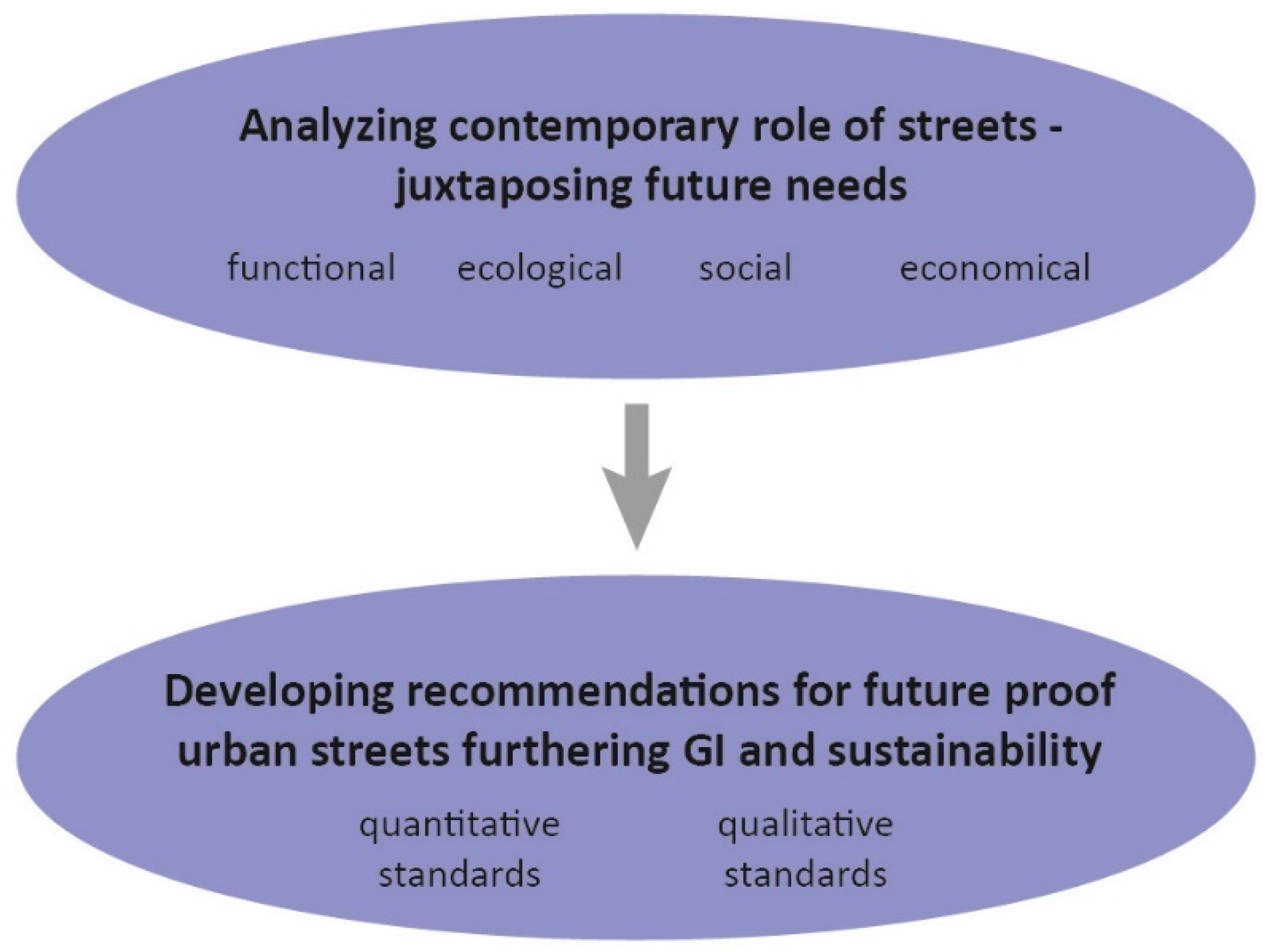
:1. Introduction
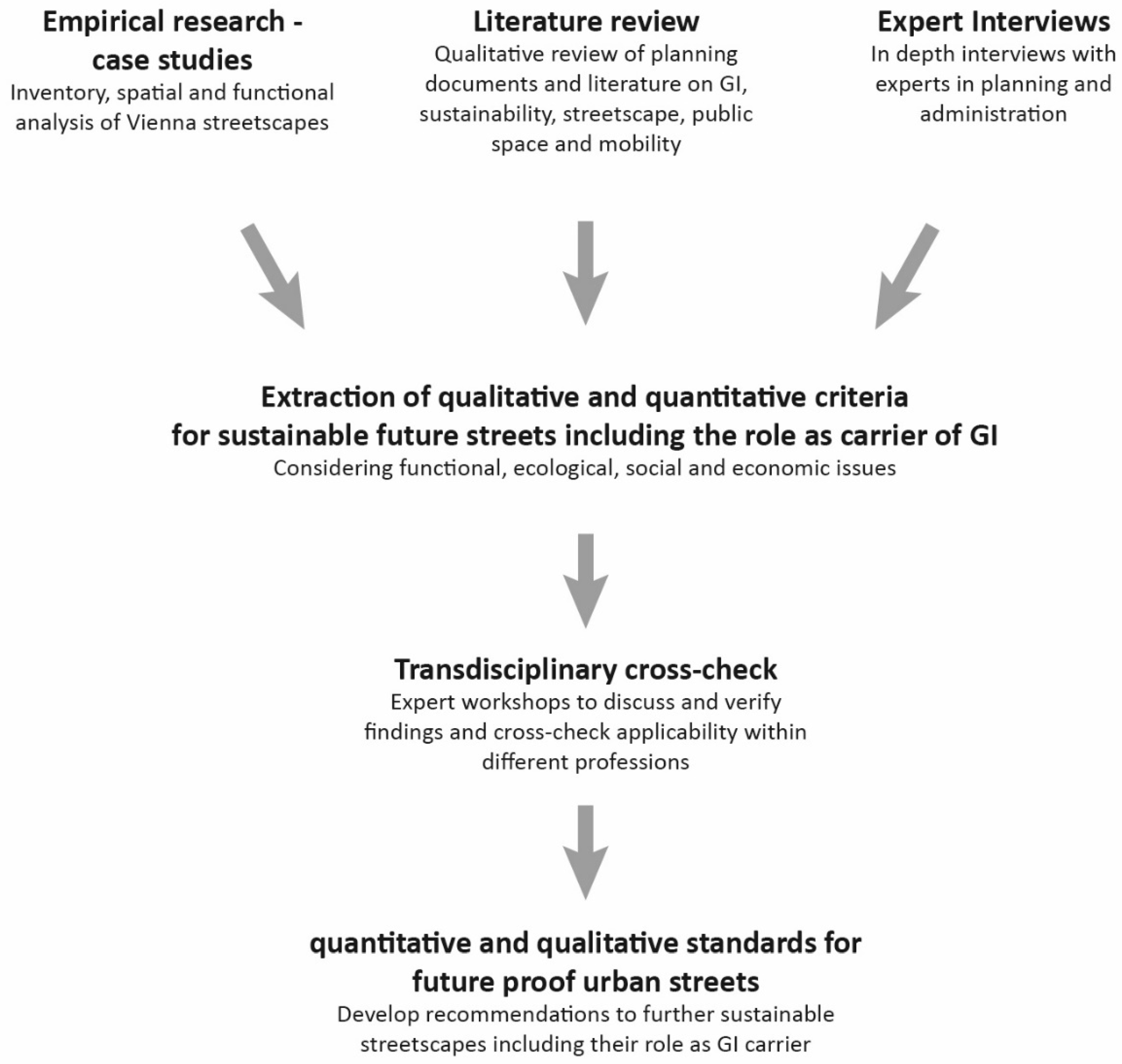
2. Materials and Methods
3. Results
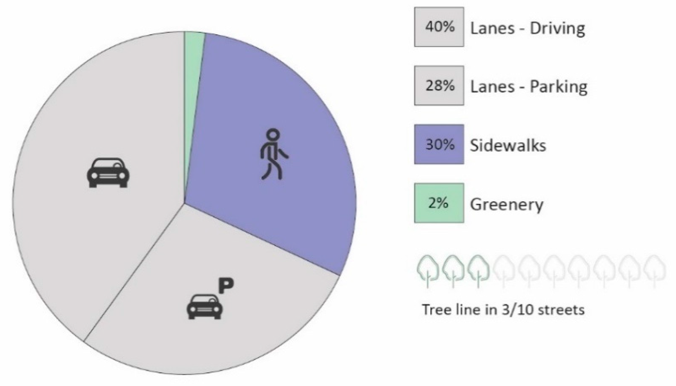
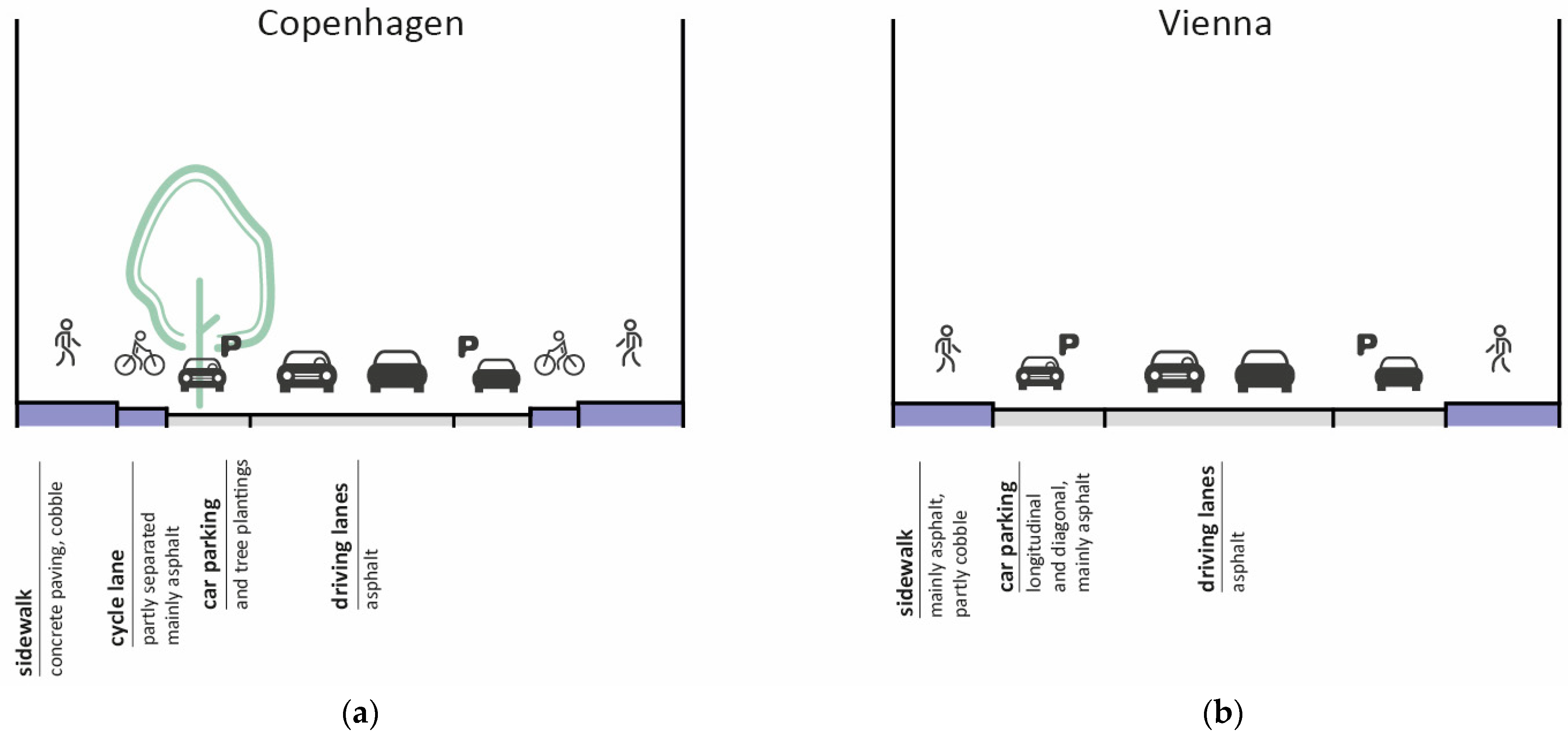
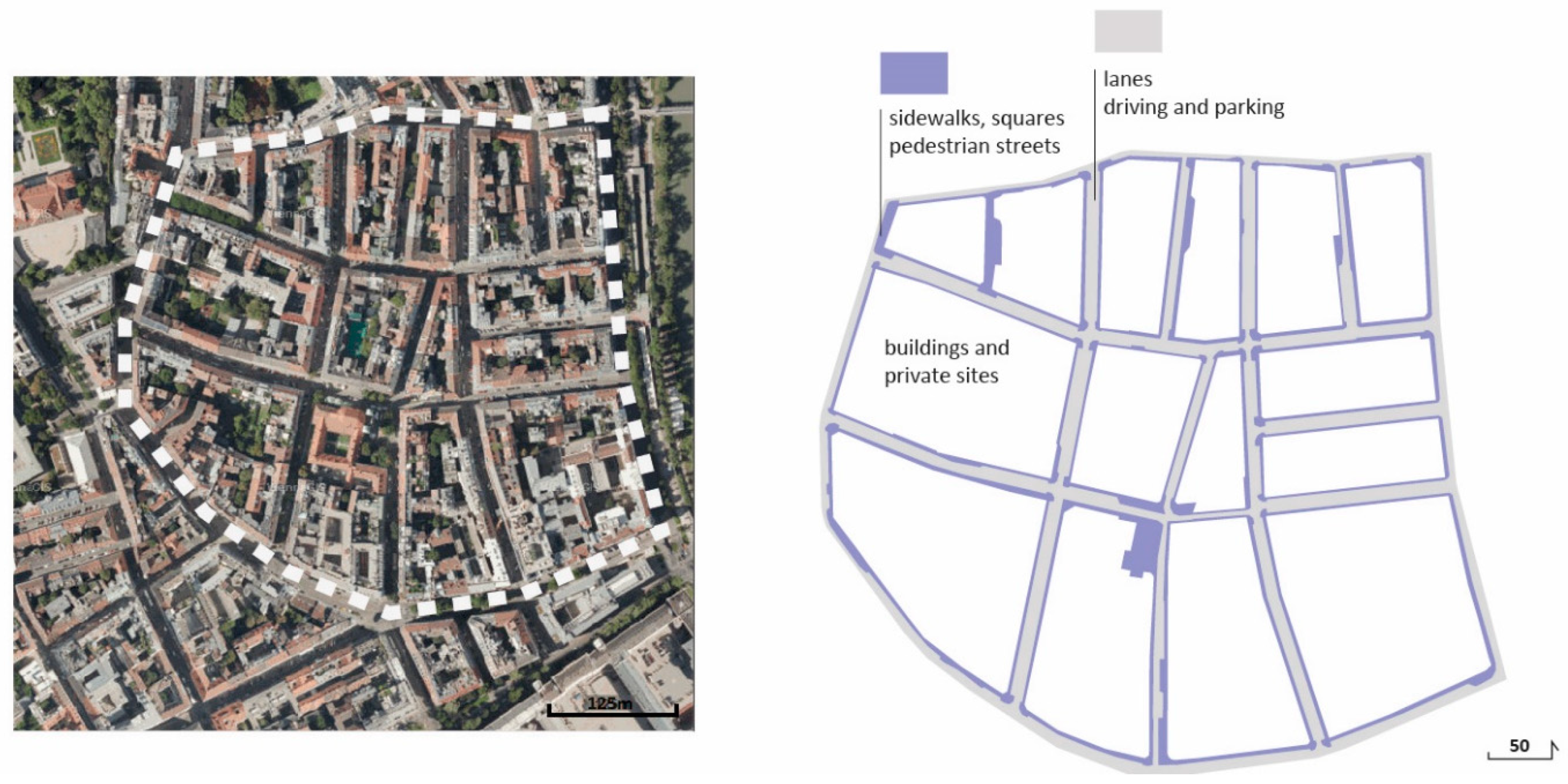
3.1. Current Situation in Vienna
3.2. Sustainable Streets: Functional, Ecological, Social and Economic Soundness
3.3. The Experts’ Point of View
3.4. Quantitative and Qualitative Recommendations for Sustainable Streets in Vienna
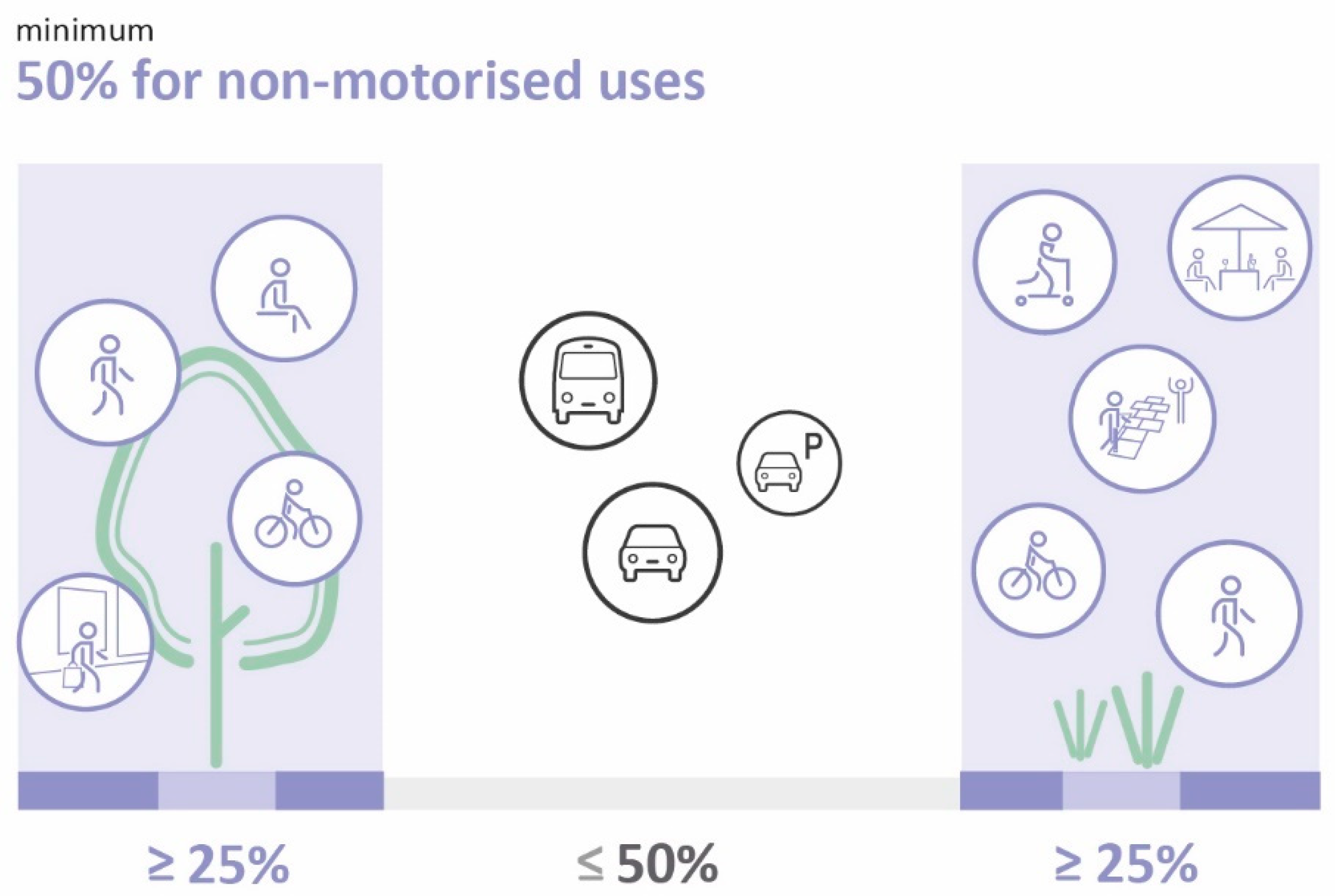
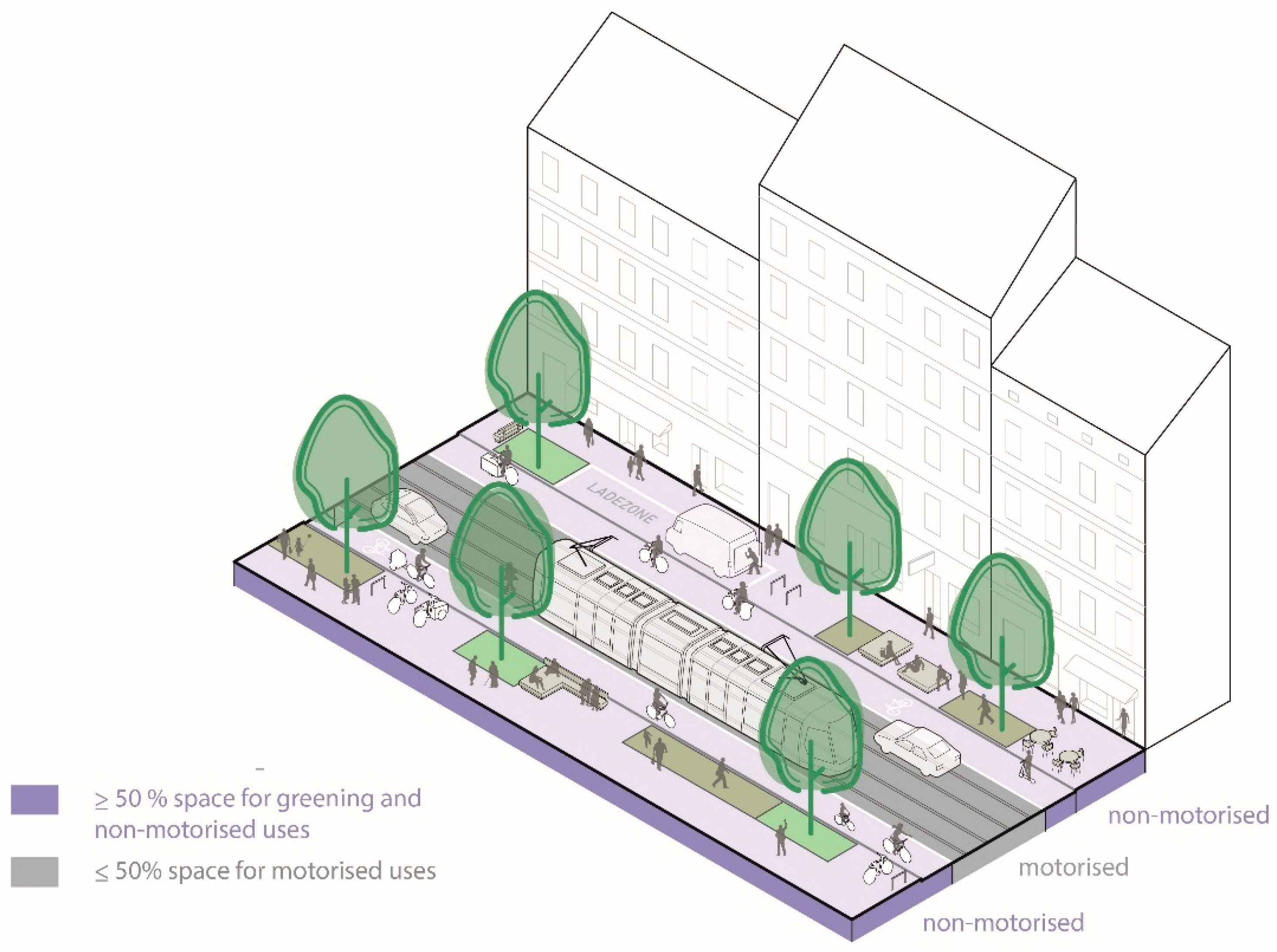
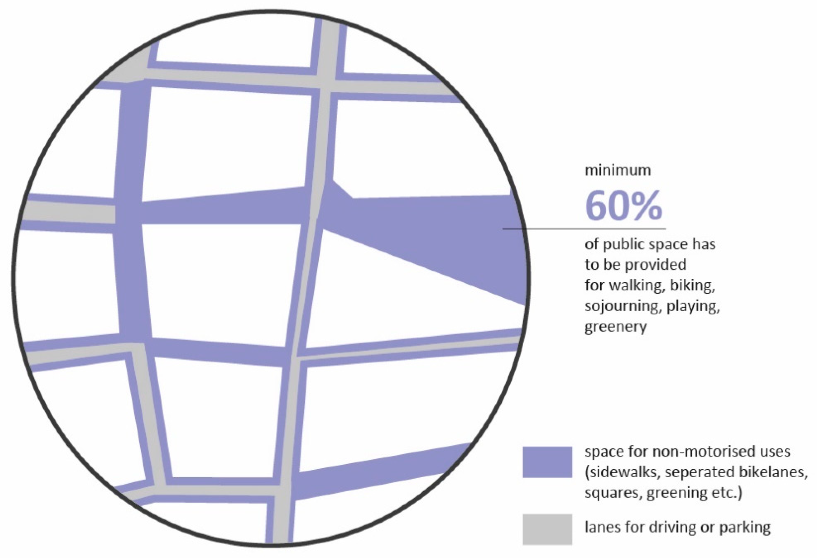
3.4.1. Spatial Provision of 50% of Public Space for Non-Motorised Uses and Greening
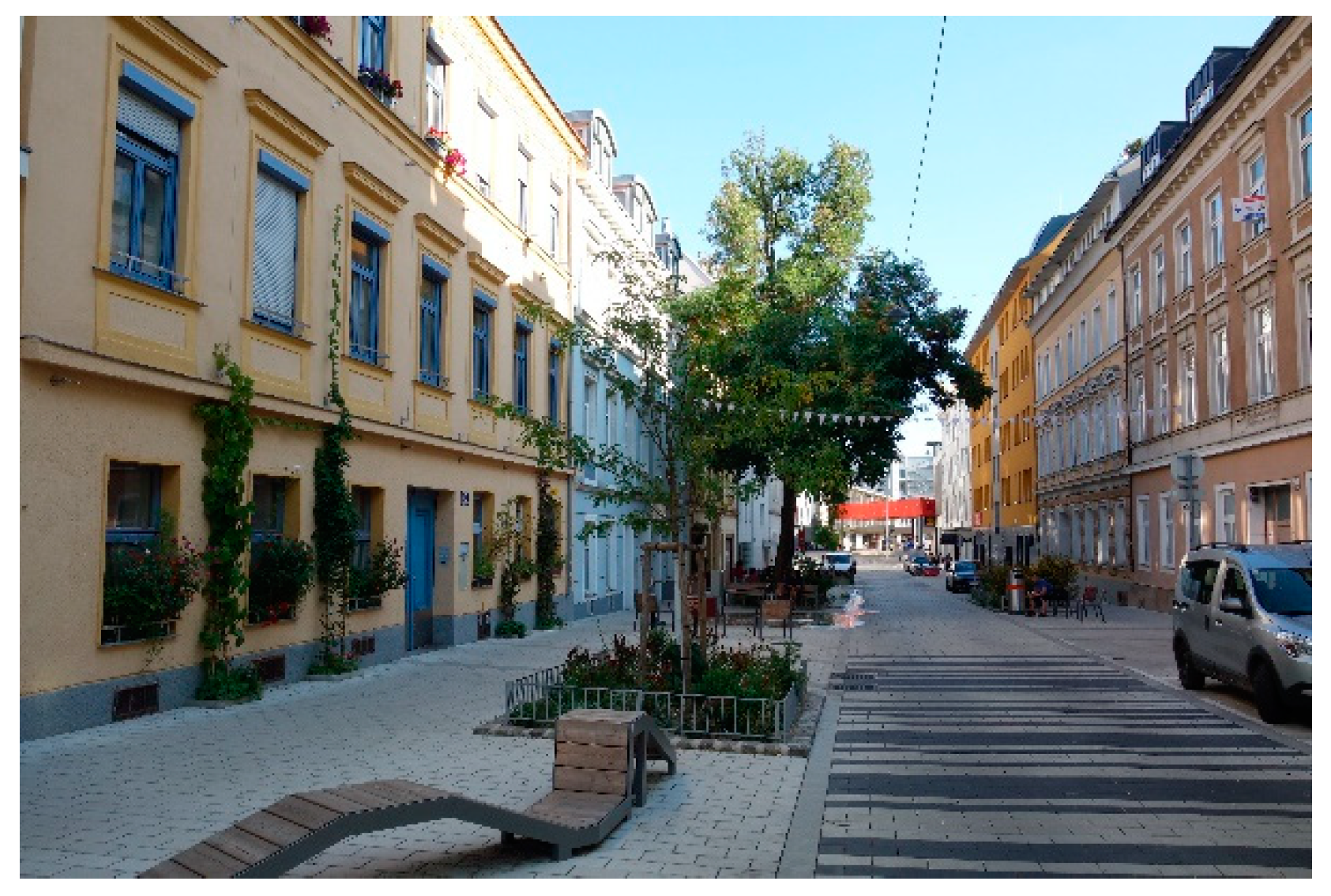
3.4.2. Safe and Inviting Design and Furnishing
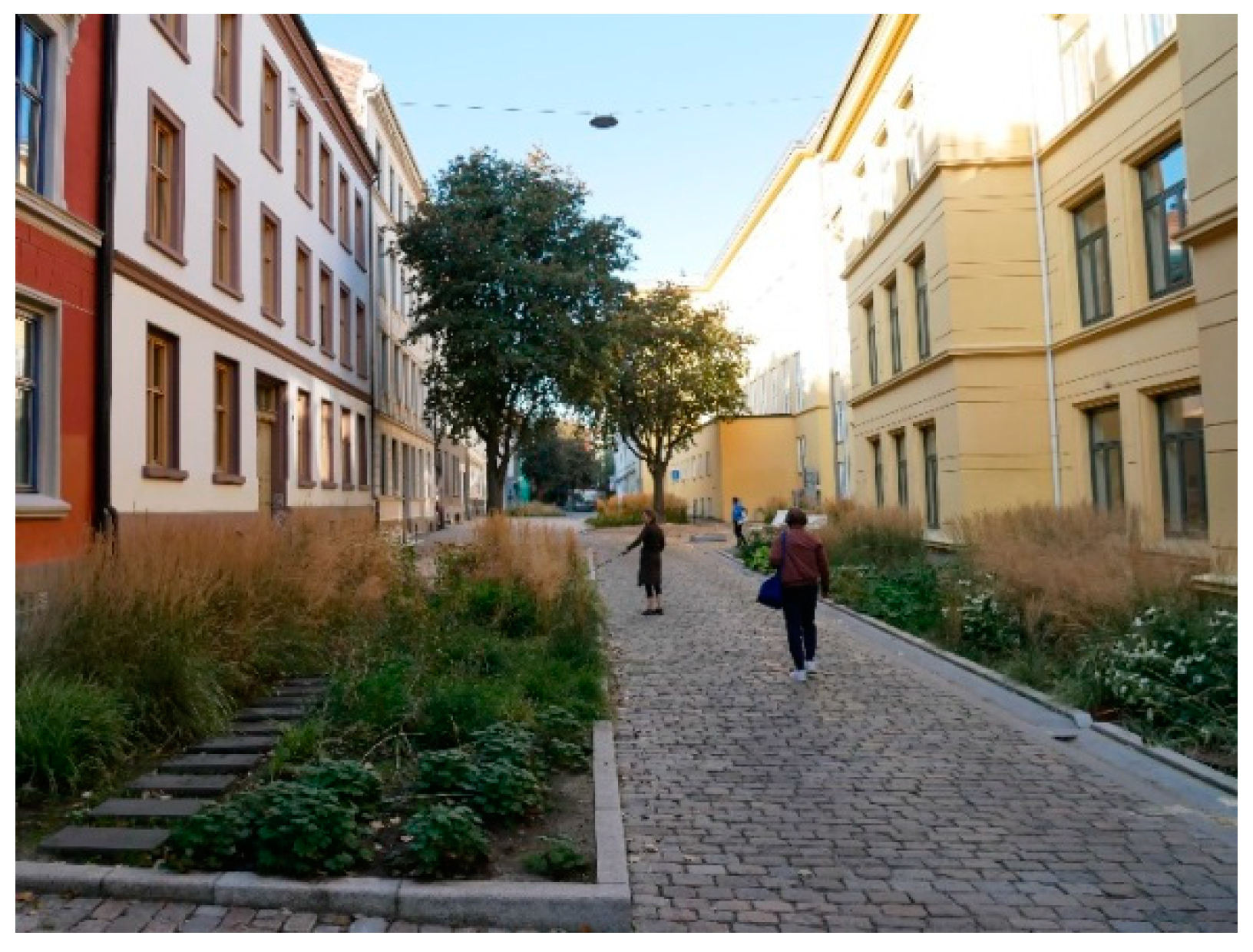
3.4.3. Vegetation and Permeable Surfaces
3.4.4. Micro-Open Spaces
3.4.5. Considering Public Institutions and Space for Appropriation and Adaption
3.4.6. Network of Squares to Complement Green Streets
3.4.7. Vital Edge Zone and Space for Commercial and Non-Commercial Uses
4. Discussion
5. Conclusions
Author Contributions
Funding
Institutional Review Board Statement
Informed Consent Statement
Data Availability Statement
Acknowledgments
Conflicts of Interest
References
- Coutts, C.; Hahn, M. Green Infrastructure, Ecosystem Services, and Human Health. Int. J. Environ. Res. Public Health 2015, 12, 9768. [Google Scholar] [CrossRef] [Green Version]
- Hunter, R.F.; Cleland, C.; Cleary, A.; Droomers, M.; Wheeler, B.W.; Sinnett, D.; Nieuwenhuijsen, M.J.; Braubach, M. Environmental, health, wellbeing, social and equity effects of urban green space interventions: A meta-narrative evidence synthesis. Environ. Int. 2019, 130, 104923. [Google Scholar] [CrossRef]
- Lennon, M.; Douglas, O.; Scott, M. Urban green space for health and well-being: Developing an ‘affordances’ framework for planning and design. J. Urban Des. 2017, 22, 778–795. [Google Scholar] [CrossRef] [Green Version]
- NACTO—National Association of City Transportation Officials. Global Designing Cities Initiative. In Global Street Design Guide, 1st ed.; Island Press: Washington, DC, USA, 2016; ISBN 9781610917018. [Google Scholar]
- UBA—Umweltbundesamt. Die Stadt von Morgen: Umweltschonend Mobil—Lärmarm—Grün—Kompakt—Durchmischt, 2nd ed.; Umweltbundesamt: Dessau-Roßlau, Germany, 2017; ISSN 2363832X. [Google Scholar]
- Wang, J.; Banzhaf, E. Towards a better understanding of Green Infrastructure: A critical review. Ecol. Indic. 2018, 85, 758–772. [Google Scholar] [CrossRef]
- Bowler, D.E.; Buyung-Ali, L.; Knight, T.M.; Pullin, A.S. Urban greening to cool towns and cities: A systematic review of the empirical evidence. Landsc. Urban Plan. 2010, 97, 147–155. [Google Scholar] [CrossRef]
- Demuzere, M.; Orru, K.; Heidrich, O.; Olazabal, E.; Geneletti, D.; Orru, H.; Bhave, A.G.; Mittal, N.; Feliu, E.; Faehnle, M. Mitigating and adapting to climate change: Multi-functional and multi-scale assessment of green urban infrastructure. J. Environ. Manag. 2014, 146, 107–115. [Google Scholar] [CrossRef]
- Coutts, C. Green Infrastructure and Public Health; Routledge: New York, NY, USA, 2016. [Google Scholar]
- Stadt Wien MA 18. Lebensqualität in 91 Wiener Bezirksteilen. Bezirksprofile der Zufriedenheit mit der Wohnumgebung; Werkstattbericht 157; Stadt Wien, Magistratsabteilung 18—Stadtentwicklung und Stadtplanung: Vienna, Austria, 2016; ISBN 9783903003125. [Google Scholar]
- City of Copenhagen. More People to Walk More: The Pedestrian Strategy of Copenhagen; The Municipality of Copenhagen, Technical and Environmental Administration: Copenhagen, Denmark, 2011. [Google Scholar]
- Furchtlehner, J.; Lička, L. Back on the Street: Vienna, Copenhagen, Munich, and Rotterdam in focus. JoLA 2019, 14, 72–83. [Google Scholar] [CrossRef]
- VCÖ, Verkehrsclub Österreich. Den Raum neu verteilen. Available online: https://www.vcoe.at/news/details/den-raum-neu-verteilen (accessed on 15 October 2021).
- Wu, J.; Feng, Z.; Peng, Y.; Liu, Q.; He, Q. Neglected green street landscapes: A re-evaluation method of green justice. Urban For. Urban Green. 2019, 41, 344–353. [Google Scholar] [CrossRef]
- Im, J. Green Streets to Serve Urban Sustainability: Benefits and Typology. Sustainability 2019, 11, 6483. [Google Scholar] [CrossRef] [Green Version]
- Rodriguez-Valencia, A.; Ortiz-Ramirez, H.A. Understanding Green Street Design: Evidence from Three Cases in the U.S. Sustainability 2021, 13, 1916. [Google Scholar] [CrossRef]
- Bendiks, S.; Degros, A. Traffic Space is Public Space. Ein Handbuch zur Transformation; Park Books: Zurich, Switzerland, 2019; ISBN 9783038601654. [Google Scholar]
- Bosselmann, P. Urban Transformation; Island Press: Washington, DC, USA, 2008. [Google Scholar]
- Mehta, V. The Street: A Quintessential Social Public Space; Routledge: New York, NY, USA, 2014; ISBN 9780415737296. [Google Scholar]
- UBA—Umweltbundesamt. Straßen und Plätze neu Denken; Umweltbundesamt: Dessau-Roßlau, Germany, 2017. [Google Scholar]
- Pregill, P. Urban Connections in the Contemporary Pedestrian Landscape; Routledge: New York, NY, USA, 2020. [Google Scholar]
- Tzoulas, K.; Korpela, K.; Venn, S.; Yli-Pelkonen, V.; Kaźmierczak, A.; Niemela, J.; James, P. Promoting ecosystem and human health in urban areas using Green Infrastructure: A literature review. Landsc. Urban Plan. 2007, 81, 167–178. [Google Scholar] [CrossRef] [Green Version]
- Zölch, T.; Maderspacher, J.; Wamsler, C.; Pauleit, S. Using green infrastructure for urban climate-proofing: An evaluation of heat mitigation measures at the micro-scale. Urban For. Urban Green. 2016, 20, 305–316. [Google Scholar] [CrossRef]
- Klemm, W.; Heusinkveld, B.G.; Lenzholzer, S.; van Hove, B. Street greenery and its physical and psychological impact on thermal comfort. Landsc. Urban Plan. 2015, 138, 87–98. [Google Scholar] [CrossRef]
- Navarrete-Hernandez, P.; Laffan, K. A greener urban environment: Designing green infrastructure interventions to promote citizens’ subjective wellbeing. Landsc. Urban Plan. 2019, 19, 103618. [Google Scholar] [CrossRef]
- Gälzer, R. Grünplanung für Städte: Planung, Entwurf, Bau und Erhaltung; Ulmer: Stuttgart, Germany, 2001; ISBN 3800131862. [Google Scholar]
- Maryanti, M.R.; Khadijah, H.; Muhammad Uzair, A.; Megat Mohd Ghazali, M.A.R. The urban green space provision using the standards approach: Issues and challenges of its implementation in Malaysia. WIT Trans. Ecol. Environ. 2016, 210, 369–379. [Google Scholar] [CrossRef] [Green Version]
- Stadt Wien MA 18. STEP 2025 Fachkonzept Grün- und Freiraum; Werkstattbericht 144; Stadt Wien, Magistratsabteilung 18—Stadtentwicklung und Stadtplanung: Vienna, Austria, 2015; ISBN 978-3-902576-95-8. [Google Scholar]
- Stadt Wien MA 18. Leitfaden zur Ermittlung der Grünraum Kennwerte; Stadt Wien, Magistratsabteilung 18—Stadtentwicklung und Stadtplanung: Vienna, Austria, 2017. [Google Scholar]
- Grün Stadt Zürich. Die Freiraumversorgung der Stadt Zürich und ihre Berechnung: Methodenbeschreib und Anwendung; Grün Stadt Zürich: Zurich, Switzerland, 2019. [Google Scholar]
- VCÖ, Verkehrsclub Österreich. Mehr Platz für bewegungsaktive Mobilität; VCÖ: Vienna, Austria, 2021; ISBN 9783903265080. [Google Scholar]
- Lele, S.M. Sustainable Development. A Critical Review. World Dev. 1991, 19, 607–621. [Google Scholar] [CrossRef]
- Open Data Österreich. Available online: https://www.data.gv.at (accessed on 13 April 2020).
- Stadt Wien. OGD Daten Download. Available online: https://www.wien.gv.at/stadtentwicklung/stadtvermessung/geodaten/viewer/geodatendownload.html (accessed on 15 October 2021).
- World Commission on Environment and Development. Our Common Future; Oxford University Press: London, UK, 1987. [Google Scholar]
- Gehl, J. Cities for People; Island Press: Washington, DC, USA, 2010; ISBN 9781597265737. [Google Scholar]
- Gössling, S. Why cities need to take road space from cars—and how this could be done. J. Urban Des. 2020, 25, 443–448. [Google Scholar] [CrossRef]
- Carmona, M. Principles for public space design, planning to do better. Urban Des. Int. 2019, 24, 47–59. [Google Scholar] [CrossRef] [Green Version]
- Francis, M. Urban Open Space: Designing for User Needs; Island Press: Washington, DC, USA, 2003. [Google Scholar]
- Häberlin, U.W.; Furchtlehner, J. Öffentlicher Raum für alle? Raumaneignung versus Gemeinwesen in der Wiener Praxis. In Aneignung urbaner Freiräume: Ein Diskurs über städtischen Raum; Hauck, T.E., Hennecke, S., Körner, S., Eds.; Transcript Verlag: Bielefeld, Germany, 2017; pp. 177–199. [Google Scholar] [CrossRef]
- Speck, J. Walkable City Rules; Island Press: Washington, DC, USA, 2018; ISBN 9781610918985. [Google Scholar]
- Transport for London. Better Streets Delivered: Learning from Completed Schemes; Transport for London: London, UK, 2013. [Google Scholar]
- Bund Deutscher Landschaftsarchitekten bdla. Grüne Infrastruktur: Zeitgenössische deutsche Landschaftsarchitektur. Green Infrastructure: Contemporary German Landscape Architecture; Birkhäuser: Basel, Switzerland, 2015. [Google Scholar]
- Dunnett, N.; Clayden, A. Rain Gardens: Sustainable Rainwater Management for the Garden and Designed Landscape; Timber Press: Portland, OR, USA, 2007; ISBN 9780881928266. [Google Scholar]
- Carmona, M. Public Places, Urban Spaces: The Dimension of Urban Design; Routledge: New York, NY, USA, 2021; ISBN 9781138067783. [Google Scholar]
- Song, S.; Funk, P. Urban Streetscape Design; Design Media Publishing Limited: Hongkong, China, 2014; ISBN 9789881296726. [Google Scholar]
- Reicher, C. Städtebauliches Entwerfen, 5th ed.; Springer: Berlin, Germany, 2017. [Google Scholar]
- City of Copenhagen. CPH 2025 Climate Plan: A Green, Smart and Carbon Neutral City. Copenhagen; City of Copenhagen, Technical and Environmental Administration: Copenhagen, Denmark, 2012. [Google Scholar]
- City of Copenhagen. Klimakvarter: Copenhagen’s first Climate Resilient Neighbourhood, 2nd ed.; City of Copenhagen: Copenhagen, Denmark, 2016. [Google Scholar]
- City of Stockholm. Environment Programme 2020–2023; City Executive Office: Stockholm, Swedem, 2020. [Google Scholar]
- Oslo Kommune. The Car-Free Liveability Programme 2019; Oslo Commune: Oslo, Norway, 2019. [Google Scholar]
- Stadt Köln. Leitfaden für eine Wassersensible Stadt- und Freiraumgestaltung in Köln; Stadtentwässerungsbetriebe Köln: Köln, Germany, 2019. [Google Scholar]
- Aslaug Lund, A.; Ramisch, T. Dänemark—Interview zum Titelthema. Gart. Landsch. 2021, 2, 12–17. [Google Scholar]
- Lička, L.; Furchtlehner, J. Changing Streets: Individual Actions, Large-Scale Measures, and Ambitious Urban Climate Goals. In Urban Landscapes in High-Density Cities; Rinaldi, T., Ed.; Birkhäuser: Basel, Switzerland, 2019; pp. 100–116. [Google Scholar] [CrossRef]
- Drlik, S. Das Schwammstadt Prinzip. Archit. Aktuell 2019, 3, 26–28. [Google Scholar]
- Flecken, U.; Calbet i Elias, L. Der öffentliche Raum. Sichten, Reflexionen, Beispiele; Universitätsverlag der Technischen Universität Berlin: Berlin, Germany, 2011; pp. 13–17. [Google Scholar]
- Kronenberg, J.; Haase, A.; Łaszkiewicz, E.A.; Antal, A.; Baravikova, A.; Biernacka, M.; Dushkova, D.; Filčak, R.; Haase, D.; Ignatieva, M.; et al. Environmental justice in the context of urban green space availability, accessibility, and attractiveness in postsocialist cities. Cities 2020, 106, 102862. [Google Scholar] [CrossRef]
- Roloff, A. Bäume in der Stadt. Besonderheiten, Funktion, Nutzen, Arten, Risiken; Ulmer: Stuttgart, Germany, 2013; ISBN 9783800175987. [Google Scholar]
- Stadt Wien MA 18. Hohe Lebensqualität in einer wachsenden Stadt? Ausgewählte Ergebnisse der Wiener Lebensqualitätsstudie 2018; Stadt Wien, Magistratsabteilung 18—Stadtentwicklung und Stadtplanung: Vienna, Austria, 2018. [Google Scholar]
- Calderón-Argelich, A.; Benetti, S.; Anguelovski, I.; Connolly, J.T.; Langemeyer, J.; Baró, F. Tracing and building up environmental justice considerations in the urban ecosystem service literature: A systematic review. Landsc. Urban Plan. 2021, 214, 104130. [Google Scholar] [CrossRef]
- Kabisch, N.; Haase, D. Green justice or just green? Provision of urban green spaces in Berlin, Germany. Landsc. Urban Plan. 2014, 122, 129–139. [Google Scholar] [CrossRef]
- Sister, C.; Wolch, J.; Wilson, J. Got green? addressing environmental justice in park provision. GeoJournal 2010, 75, 229–248. [Google Scholar] [CrossRef]
- Wen, C.; Albert, C.; Von Haaren, C. Equality in access to urban green spaces: A case study in Hannover, Germany, with a focus on the elderly population. Urban For. Urban Green. 2020, 55, 126820. [Google Scholar] [CrossRef]
- Zavestoski, S.; Agyeman, J. Incomplete Streets: Processes, Practices, and Possibilities; Routledge: London, UK, 2015. [Google Scholar]
- VCÖ, Verkehrsclub Österreich. In Wien mehr Fahrrad-Haushalte als Auto-Haushalte. Available online: https://vcoe.at/presse/presseaussendungen/detail/vcoe-in-wien-mehr-fahrrad-haushalte-als-auto-haushalte (accessed on 15 October 2021).
- Bork, H.; Klinger, S.; Zech, S. Kommerzielle und nicht-kommerzielle Nutzung im öffentlichen Raum; Stadtpunkte 16; Arbeiterkammer Wien: Vienna, Austria, 2015. [Google Scholar]
- Furchtlehner, J.; Bautz, G. Tough Choice—Easy Decision. How to handle Installations in public urban space. Spool 2018, 5, 19–35. [Google Scholar]
- Sim, D. Soft City, Building Density for Everyday Life; Island Press: Washington, DC, USA, 2019. [Google Scholar]
- Psenner, A. Das Wiener Gründerzeit-Parterre—Eine analytische Bestandsaufnahme. Pilotstudi—Abschlussbericht; Städtebau TU Wien: Vienna, Austria, 2012. [Google Scholar]
- Bielefeld, B. Raummaße Architektur: Flächen, Abstände, Abmessungen; Birkhäuser: Basel, Switzerland, 2018. [Google Scholar]
- Thamm, U.; Weninger, A.; Gungl, B.; Studer, H. Öffentliche Räume in Stadtentwicklungsgebieten Wiens; Stadtpunkte 23; Arbeiterkammer Wien: Vienna, Austria, 2017. [Google Scholar]
- Stadt Wien MA 18 und MA 19. STEP 2025 Fachkonzept Öffentlicher Raum; Werkstattbericht 175; Stadt Wien, Magistratsabteilung 18—Stadtentwicklung und Stadtplanung: Vienna, Austria, 2018; ISBN 9783903003415. [Google Scholar]
- Stadt Wien MA 18. STEP 2025, Fachkonzept Mobilität; Werkstattbericht 145; Stadt Wien, Magistratsabteilung 18—Stadtentwicklung und Stadtplanung: Vienna, Austria, 2015; ISBN 9783902576972. [Google Scholar]
- RVS. Richtlinien und Vorschriften für das Straßenwesen; Österreichische Forschungsgesellschaft Straße, Schiene, Verkehr Österreichische Forschungsgemeinschaft Straße und Verkehr: Wien, Austria, 2012. [Google Scholar]
- Zimmermann, A. Elemente der Landschaft. Flächen, Abstände, Dimensionen; Birkhäuser: Basel, Switzerland, 2020; ISBN 9783035618563. [Google Scholar]
- Vernon, S.; Vernon, S.; Tennant, R.; Garmory, N. Landscape Architect’s Pocket Book Landscape Architect’s Pocket Book; Routledge: London, UK, 2013. [Google Scholar]
- City of San Francisco. San Francisco Parklet Manual 2.2; City of San Francisco: San Francisco, CA, USA, 2015. [Google Scholar]
- Tadler, J.; Girardi, M. Bedarf und Potenziale. Eine Strategie Urbaner Öffentlicher Räume für Wien—Teil 1; Unpublished; Im Auftrag Magistrat der Stadt Wien, MA 18: Vienna, Austria, 2012. [Google Scholar]
- Alexander, C.; Ishikawa, S.; Silverstein, M.; Jacobson, M.; King, I.; Angel, S. Eine Muster-Sprache. Städte, Gebäude, Konstruktion; Löcker: Vienna, Austria, 1995; ISBN 3854091796. [Google Scholar]
- Stadt Wien MA19. Schanigarten—Ein Leitfaden; Stadt Wien, Magistratsabteilung 19—Architektur und Stadtgestaltung: Vienna, Austria, 2019; Available online: https://www.wien.gv.at/stadtentwicklung/studien/pdf/e000004.pdf (accessed on 29 October 2021).
- Furchtlehner, J.; Lehner, D.; Lička, L. Transformation des öffentlichen urbanen Raums—Eine Werteverschiebung? In Interdisziplinäre Stadtforschung—Themen und Perspektiven; Kogler, R., Hamedinger, A., Eds.; Transcript Verlag: Bielefeld, Germany, 2021; pp. 283–307. [Google Scholar]
- Klimakarte Stadt Wien. Available online: https://www.wien.gv.at/stadtentwicklung/grundlagen/stadtforschung/stadtklimaanalyse.html (accessed on 30 November 2021).
- Bakradze, L. Öffentlicher Raum—Vom Verkehrsraum zum Lebensraum? In Der öffentliche Raum: Sichten, Reflexion, Beispiele; Flecken, U., Calbet i Elias, L., Eds.; Sonderpublikation des Instituts für Stadt und Regionalplanung Technische Universität Berlin: Berlin, Germany, 2011; pp. 49–59. [Google Scholar]
- Haase, D.; Kabisch, S.; Haase, A.; Andersson, E.; Banzhaf, E.; Baró, F.; Brenck, M.; Fischer, L.K.; Frantzeskaki, N.; Kabisch, N.; et al. Greening cities—To be socially inclusive? About the alleged paradox of society and ecology in cities. Habitat Int. 2017, 64, 41–48. [Google Scholar] [CrossRef]
- BCNUEJ—Barcelona Laboratory for urban Environmental Justice and Sustainability. Policy and Planning Tools for Urban Green Justice; BCNUEJ: Barcelona, Spain, 2021; Available online: http://www.bcnuej.org/wp-content/uploads/2021/04/Toolkit-Urban-Green-Justice.pdf (accessed on 6 December 2021).
- Ajuntament de Barcelona. Urban Mobility Plan of Barcelona 2013–2018; Ajuntament de Barcelona: Barcelona, Spain, 2014. [Google Scholar]


| Vienna Survey Areas | Total Survey Area in m² | Public Space (Streets, Squares) in m² | Space for Motorised Uses m² | Space for Motorised Uses % | Space for Non-Motorised Uses m² | Space for Non-Motorised Uses % | |
|---|---|---|---|---|---|---|---|
| 1 | Seestadt Aspern, 22nd district | 121,000 | 49,500 | 17,000 | 34% | 32,500 | 66% |
| 2 | Sonnwendviertel, 10th district | 156,000 | 60,000 | 32,500 | 54% | 27,500 | 46% |
| 3 | Nordbahnhof, 2nd district | 150,000 | 55,000 | 27,500 | 50% | 27,500 | 50% |
| 4 | Carré Atzgersdorf, 23rd district | 110,000 | 37,500 | 13,000 | 35% | 24,500 | 65% |
| 5 | Margareten, 5th district (old quarter) | 190,000 | 42,500 | 25,000 | 59% | 17,500 | 41% |
| 6 | Servitenviertel, 9th district (old quarter) | 180,000 | 48,000 | 28,000 | 58% | 20,000 | 42% |
| 7 | Währing, 18th district (old quarter) | 147,000 | 36,500 | 24,000 | 66% | 12,500 | 34% |
| Sustainable Streets—General Summarising Considerations | Recommendations for Vienna | |
|---|---|---|
| Functional Aspects | Streets as quality public space; Streets as GI; Accessibility and safe movement, fostering environmentally friendly, non-motorised and public transport modes |
|
| Ecological aspects | Streets as a component of GI network, carriers of flora and fauna; Rainwater management |
|
| Social aspects | Enabling optional and social activities; Room for appropriation; Accessibility; Ground-floor interaction; Identification/neighbourhood |
|
| Economic aspects | Vitality and supply |
|
Publisher’s Note: MDPI stays neutral with regard to jurisdictional claims in published maps and institutional affiliations. |
© 2022 by the authors. Licensee MDPI, Basel, Switzerland. This article is an open access article distributed under the terms and conditions of the Creative Commons Attribution (CC BY) license (https://creativecommons.org/licenses/by/4.0/).
Share and Cite
Furchtlehner, J.; Lehner, D.; Lička, L. Sustainable Streetscapes: Design Approaches and Examples of Viennese Practice. Sustainability 2022, 14, 961. https://doi.org/10.3390/su14020961
Furchtlehner J, Lehner D, Lička L. Sustainable Streetscapes: Design Approaches and Examples of Viennese Practice. Sustainability. 2022; 14(2):961. https://doi.org/10.3390/su14020961
Chicago/Turabian StyleFurchtlehner, Jürgen, Daniela Lehner, and Lilli Lička. 2022. "Sustainable Streetscapes: Design Approaches and Examples of Viennese Practice" Sustainability 14, no. 2: 961. https://doi.org/10.3390/su14020961