Article

An Innovative Framework on Spatial Boundary Optimization of Multiple International Designated Land Use

1
The Architectural Design & Research Institute of Zhejiang University Co., Ltd., Zhejiang University, Hangzhou 310028, China
2
Center for Balanced Architecture, Zhejiang University, Hangzhou 310058, China
3
College of Agriculture and Biotechnology, Zhejiang University, Hangzhou 310058, China
4
College of Computer Science and Technology, Zhejiang University, Hangzhou 310058, China
5
Department of Landscape Architecture, Huazhong Agricultural University, Wuhan 430070, China
*
Author to whom correspondence should be addressed.
Sustainability 2022, 14(2), 587; https://doi.org/10.3390/su14020587
Submission received: 3 December 2021 / Revised: 31 December 2021 / Accepted: 1 January 2022 / Published: 6 January 2022
(This article belongs to the Special Issue Urban Planning and Sustainable Land Use)

Abstract

:
The continuous improvement of international protection awareness has dramatically increased the number of protection organizations and promoted various reserve-naming methods. However, the existing global natural reserves have either fully or partially overlapped, thereby allowing the same region to hold various international titles, resulting in serious issues, which are especially manifested in the boundary delimitation process of natural reserves. Therefore, delimiting the titles of reserve borders will become an enormous challenge in protected-area governance worldwide. This study conducted an in-depth investigation of the technical methods for delineating the spatial boundaries of natural reserves. Taking Jiangshan Nature Reserve in China as the case object, the Candidate Area–Natural background–Heritage Resource–Construction (C-NHC) framework was constructed, and the boundaries of the new reserves were delineated. This study has changed the status quo of the spatial overlap of the reserve through the quantitative evaluation of the conflict patches and the triple optimization of the boundary of the reserve. The area of the new reserve is 150.524 km2, which is 6.682 km2 larger than the original one. The original reserves are all included within the scope of the new one. This study provides guidance and new insights into the boundary delineation of integrated nature reserves worldwide.

1. Introduction

Industrialization and urbanization continue to expand globally, along with the continuous development of the human society [1,2]. Excessive resource utilization has exacerbated the disappearance and fragmentation of habitats [3,4], thereby inducing soil erosion, environmental pollution [5,6], and biodiversity loss [7]. The International Union for Conservation of Nature and its state parties have established numerous natural reserves as powerful tools for protecting natural resources, maintaining biodiversity [8,9], improving ecosystem services [10], and introducing economic benefits to the surrounding areas to cope with the increasingly severe challenges of the ecological environment. The resources of the reserves are still damaged despite the constantly expanding scale of natural reserves and may further degrade the ecosystem protection function due to people who are driven by economic benefits, thus contradicting the original intention of the establishment of natural reserves [11].
However, the continuous improvement of international protection awareness has dramatically increased the number of protection organizations and promoted various reserve naming methods [12] under different objectives, purposes, and management requirements, thereby causing the same region to hold two, three, or even four international titles [13]. Natural reserves with multiple titles reflect the high value of environmental protection and sustainable development. However, the existence of multiple titles also causes several problems, as follows [14]:
First, different titles lead to differences in protection objects and management modes, and the various monitoring and reporting requirements may instigate some conflicts and consequently increase the workload of the reserves. Second, constructing a unified management model in the absence of national regulations and controls is difficult due to a lack of communication and coordination among the institutions and departments involved in the management of multi-title reserves. Third, large spatial differences among the different titles of the same nature reserve may exist; that is, the boundaries of the reserve may be non-overlapping. Therefore, the difficulty in managing the reserves may increase. Fourth, multiple titles elicit confusion in the reserve identification system and weaken the effectiveness of international protection titles, thereby hindering the satisfactory fulfilment of the corresponding roles. Fifth, the international influence created by the multiple titles of natural reserves promotes the development of local tourists but also induces substantial pressure on the management.
The complex correspondence between the various types of protection and resource causes the widespread phenomenon of overlapping protection objects in Jiangshan, and this wastes the resources and aggravates conflicts in protection provisions and departments [15]. Therefore, solving the problem of overlapping boundaries of protected areas caused by the overlapping of multiple international designated areas and delimiting scientific protected area boundaries are of considerable importance for realizing efficient management of natural protected areas in Jiangshan. We conducted an in-depth study of this difficult problem to provide technical support for the boundary demarcation in the integration of protected areas in Jiangshan.
In this paper, a technical framework for the delimitation of nature reserves in Jiangshan is proposed. Different suggestions for the development of multi-title natural reserves from three levels, namely local managers, national institutions, and international organizations, have been proposed by the existing studies. However, most of these suggestions remain in the policy and theoretical guidance levels, fail to clearly define the spatial scope of multi-title nature reserve, and lack the methods for delineating the boundaries of nature reserves. This study proposes an evaluation index system for the integration and optimization of reserve boundaries on the basis of the Candidate Area–Natural background–Heritage Resource–Construction (C-NHC) framework; optimizes the boundaries of natural reserves on the basis of the characteristics of the resource background, heritage resource characteristics, and construction management conditions thrice; and establishes a set of identifiable and popularized technical framework for the demarcation of the boundaries of natural reserves that will exert an extensive influence on the in-depth analysis of the spatial pattern of natural reserves in the future, improvement of the planning and management, and overall promotion of the construction of natural reserves. This technical framework can provide a useful reference for the boundary delimitation of nature reserves in China and even the world.

2. Socioecological Framework

The goal of optimizing the boundary of the reserves must be addressed to solve the problems caused by the fragmentation of the administrative areas [16]. Therefore, the principle of integration and merging of adjacent reserves was established in this study. Adjacent reserves within the same geographical unit that possess strong ecosystem integrity, similar protected objects, and satisfactory management conditions were integrated preferentially [17]. Therefore, the overlapping areas after the integration of the adjacent reserves are processed in accordance with the principle of “no decrease in strength, no decrease in area, and no change in properties”.
The delimitation of the boundary of natural reserves should involve the establishment of an effective connection through land space planning and concurrently focus on the coordination of natural reserves with the urban development boundary, permanent basic farmland, and ecological protection red line to conduct element-based, micro, and precise assessments of the suitability of land space utilization and preliminarily delimit the waiting area of natural reserves. In addition, the development and utilization of territorial spaces should match the carrying capacity of the resources and environment to guide the positioning of regional main functions, clarify the order of the territorial space development, and improve the utilization efficiency of the territorial spaces.
The characteristics of the natural resources, such as topographical features, hydrological basins, soils, and flora and fauna in the natural protected areas, are the cornerstone of the natural ecological protection framework. This framework provides a basic analysis unit for the construction and boundary demarcation of the reserves. Most of the existing studies use natural geographical units as the basis for such demarcation [18,19]. The initial boundary is regarded as the reference for the superposition of the vegetation, climate, soil, animal zoning, and other elements to form the spatial boundary of natural reserve lands [20,21]. This study performed the preliminary aggregation and optimization for the boundaries of nature reserves based on their background characteristics.
Integrity is an internationally recognized principle of world heritage protection [22]. In Recommendation concerning the Preservation of Cultural Property endangered by Public or Private Works, which was formulated in 1968, UNESCO mentioned that the preservation of monuments should be an absolute requirement of any well-designed plan for urban redevelopment, especially in historic cities or districts. Similar regulations should cover the area surrounding a scheduled monument or site and its setting to preserve its association and character [23]. While integrity was introduced only recently (2005), it was an implicit quality for many cultural properties even before it was formally named [24]. Recent applications of the integrity principle in the context of heritage conservation place an emphasis on assessing and maintaining the outstanding universal value and complete representation of both natural and cultural heritage features and their attributes [25]. On the basis of protecting ecosystem integrity and biodiversity and maintaining landscape characteristics, this study extracted the three aspects of the spatial elements, namely ecological corridor, patch and matrix, and natural and human landscape elements, as well as other heritage resource characteristics, to delimit the boundary of the reserves according to guidelines and specifications.
From the perspective of practical constraints, the management status and construction conditions of the reserves are important factors that influence the cost of implementing a new space control system and, thus, directly determine whether the delimitation of the boundaries of nature reserves can be strictly and effectively implemented [26]. This study combines and adjusts the specific situation of space control and human development and construction activities [27,28] based on the comprehensive evaluation of the resource background and characteristics of the heritage resources to execute the tertiary optimization of natural reserve boundaries.
A C-NHC framework was constructed in this study to perform the boundary delineation and tertiary optimization of a new reserve. First, the preliminary candidate areas of the reserve range are selected by constructing the evaluation index system. Second, the core elements of the reserve boundary optimization are selected to evaluate the resource background elements for the initial aggregation optimization. Finally, the secondary optimization range is obtained by combining the characteristics of the heritage resources, and the third optimization is completed by connecting the existing construction regulation conditions to generate a new nature-reserve boundary.

3. Methods and Data

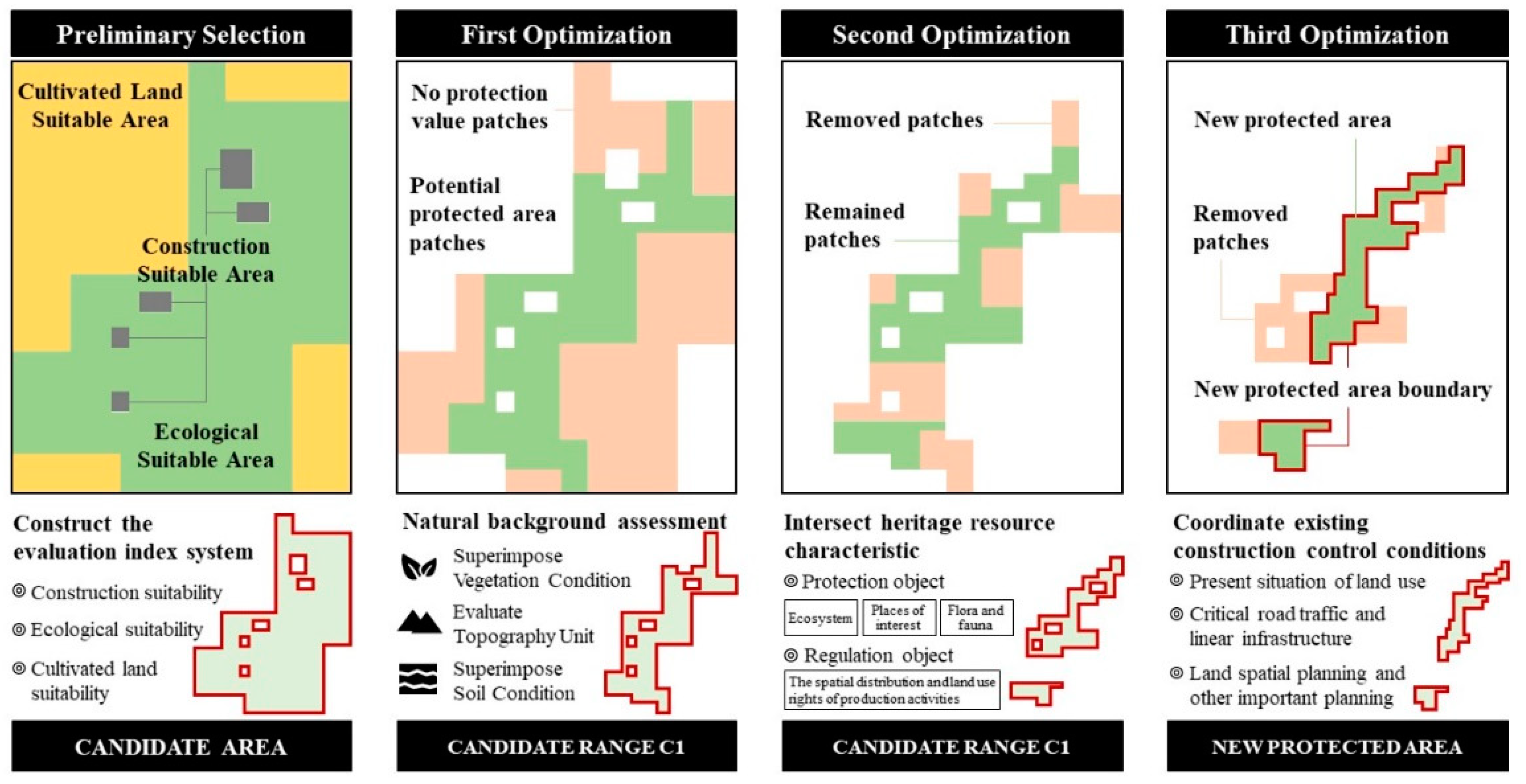
3.1. Preliminary Selection of the Candidate Areas within the Reserve

As an important part of the territorial space planning system, the construction of a natural reserve system must strengthen the connection between the natural reserve plan and the national spatial planning and comprehensively evaluate the conflicts among the spatial layout of the natural reserve, urban development boundary, red line for the permanent basic farmland protection, and ecological red line. On this basis, the spatial grid evaluation of natural reserves is performed to evaluate and compare the ecological land use, cultivated land, and urban development needs of the conflicting spots [29]. Grid evaluation can refer to the evaluation model of Foundation-Process Management. To integrate protected areas, the natural factors of the land resources; transportation conditions; spatial location; and the other factors necessary to construct an evaluation index system, including ecological, cultivated land, and construction suitability, must be comprehensively considered. The evaluation unit of this part is the map used in the area. The index is standardized by the extreme value linear standardization method for dimensionless values between 0 and 100. It assigns equivalent weight to the suitability factor and the neighborhood influence factor. The suitability comprehensive index of each land type can be calculated as follows:
S i = C i × T i × N i = j = 1 α c i , j × ( k = 1 β t i , k ϖ 1 k ) ( l = 1 λ n i , l ϖ 2 l )
where Si is the suitability of the conflict map for the i-th land type; i represents a certain land type (ecological, cultivated, or construction land); Ci, Ti, and Ni respectively represent the scores of the restrictive, suitability, and neighborhood influence factors; ci,j denotes the restriction type of the j-th restriction factor for the i-th land type, where a value of 0 and 1 represents the restriction of the existence of the i and i-th land types, respectively; ti,k represents the suitability degree of the j-th suitability factor for the i-th land type and for the positive correlation indicators; ti,k is the normalized value of the k-th index, which is the difference between 100 and the normalized value of the k-th index for reverse correlation indicators; and ϖ 1 k represents the weight of the k-th suitability factor, which is obtained through the analytic hierarchy process (AHP) [30]. AHP is a structured technique for organizing and analyzing complex decisions based on mathematics and psychology (Figure 1). Moreover, ni,l represents the degree of influence of the l-th neighborhood factor on the i-type land; ϖ 2 l represents the weight of the first neighborhood influence factor for positive correlation indicators, which is obtained through AHP; and j, k, and n represent the number of the restriction, suitability, and neighborhood influence factors, respectively.
On the basis of the calculated land-use competitiveness of conflict maps, the discriminant matrix is used to qualitatively evaluate the suitable land type for the conflict spot. The qualitative evaluation results of competitiveness are divided into three categories, namely high, medium, and low, through the natural breakpoint method (Appendix A, Table A1). The quantitative structure of various types of land-suitability levels is represented by statistical charts, and the distribution of various land-use levels is illustrated by the spatial-distribution-map characteristics. The appropriate land-classification matrix is used to calculate the appropriate land types of each conflict map. Subsequently, the classified conflict map and the original map are merged to generate the distribution maps of the different land types [31].

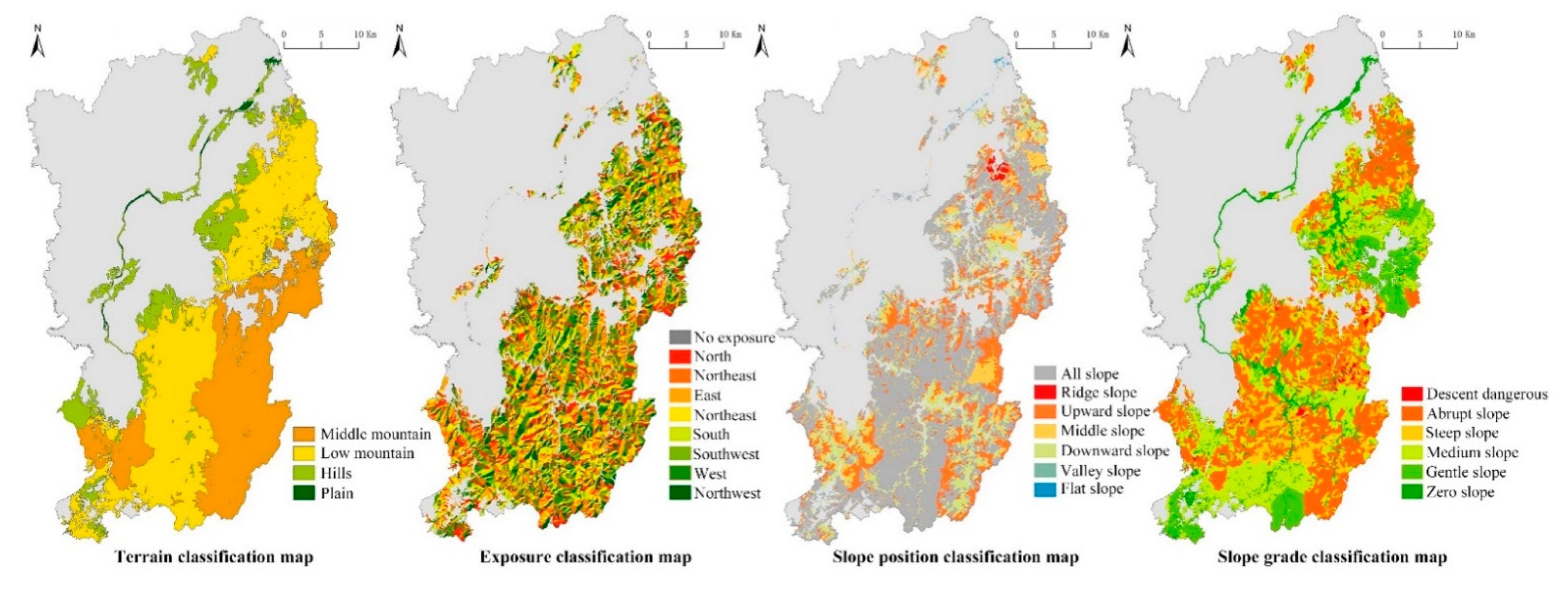
3.2. First Optimization: Resource Background Assessment and Initial Aggregation Optimization

After the features of the geomorphology, soil, and vegetation characteristics were comprehensively analyzed, the corresponding analysis units with similar characteristics were clustered and classified, and the identified candidate areas for reserve designation were divided into two areas. These divided areas are PIN and POUT, which refer to the areas within and outside the original protected area, respectively. The average values of each resource of PIN and POUT were calculated according to the graded background characteristics of the resource.
All spots outside the original reserve are reclassified into two categories according to the similarity of the resource background characteristics, namely potential protected and non-protected spots. Furthermore, the preliminary candidate range of the reserves is determined. The similarity is calculated based on Euclidean distance, as follows:
S i m ( m , T ) = 1 1 + p = 1 q ( V m p V T p ) 2
where V m p represents the value of the p-th feature of the m-th spot, and V T p is the average value of the p-th feature of PIN or POUT [32].

3.3. Second Optimization: Intersection of the Characteristic Elements of Heritage Resources and Clustering of Resource Bases

This study optimized the intersection between the extracted characteristic elements of the heritage resources and the clustering results of the resource bases and divided the former into protection objects while maintaining the conditions under control to ensure the authenticity and integrity of the ecosystem and the biodiversity of the natural reserves [22,33]. The elements of the protection objects include all kinds of important natural ecosystems, wild animal and plant habitats, geological relics, natural landscapes, protected values, and geographical distribution in the reserve. The priority of the feature extraction of the heritage resources is determined by combining the main function orientation and core protection objectives of the reserve. This step guarantees the integrity, authenticity, connectivity, and systematic nature of the core protection objectives. Subsequently, the reference elements of the ecosystem and distribution characteristics of important animals and plants and landscape remains were extracted in accordance with the patch–corridor–matrix model. Lastly, the boundary of the reserve was aggregated, smoothed, and re-optimized. Specifically, the important ecological origins of various ecosystems and habitats of important species were first determined. The least-resistance model was then used to compute the internal corridor, which was optimized with adjustments to the computed corridor in combination with the observations on the solid and species migration corridors. The important environmental matrix, which aims to ensure the integrity of the ecosystem and species structure, was extracted in accordance with the network structure comprising patch–corridor after setting a reasonable buffer width. Finally, all the extracted spatial feature elements were integrated on the basis of the following principles: the low-security level obeys the high-security level, and the secondary protection object obeys the primary protection object.
The elements of the regulatory conditions include the spatial distribution and land-use-right information of the development and production activities involving the minerals, forest farms, pastures, orchards, fishponds, and farms within the reserve. These factors were integrated, and the spatial boundaries, which exert a considerable impact on the reserve space control, were extracted or redefined and combined with the adjusted and optimized reserve spatial boundaries. Specifically, the existing construction and zoning control situations in the protected areas should be first coordinated and unified, the implementation of high-level control boundary should be prioritized, and the adjustment of low-level control boundary should be optimized. Then, in combination with the current situation of land use and natural resource development and management, the range dimensions of land, natural resource development and management, and tourism franchise ownerships should be clarified, and the boundary between state-owned property rights and collective or private property rights should be distinguished. Therefore, the development intensity of collective land, the production and development intensity of natural resources from private or collective ownership, and the profitability and the development intensity of existing franchises are evaluated. The appropriate assessment and exit of the protected or core protection areas would be conducted after estimating the space control cost of different intensities of protected areas, and the boundaries of the reserves would be adjusted. Combining the above points, the recommended selection of referable elements for the boundary optimization of protected areas is shown in Table 1:

3.4. Third Optimization: Connection and Coordination of the Existing Construction Control Conditions

With consideration of the management status and construction conditions of the reserve, the principle of “continuity, stability, conversion, and innovation” is adopted to link and coordinate the construction control elements and the secondary optimization results. The land-use-status information provided in the national land-use survey and the space area of the proposed protected land was superposed and checked to coordinate the residential construction land, historical and cultural site protection areas, permanent basic farmland, ecological protection red line, and exploration and mining rights. Afterward, the conflict area is determined, and the priority rules and compatibility control conditions in conflict processing are established prior to optimizing the boundary again. The superimposed status of important road traffic and linear infrastructure distribution map focus on the analysis of the cutting strength and crossing grade of the linear infrastructure running through the protected land according to the linear infrastructure, with strong cutting boundary function fine-tuning of the protected land boundary.
The preliminary delimitation map of the protected land should be overlapped with the land space and the major project planning maps in equal weight to place the agricultural, mineral, and major project lands from the preliminary boundary of the protected land as far as possible. Then, the boundary should be adjusted according to the important control line defined in the plan to determine the new boundary of the reserve. Figure 2 demonstrates the technical route mentioned above.

3.5. Study Area

The aforementioned problems are eminent in China [34], which has nine types of natural reserves. Reserves with different names, such as national scenic spots, national nature reserves, and local government-level reserves, exist within the same geographical space, thus resulting in overlapping reserve boundaries. To solve the problem of overlapping boundaries of protected areas caused by the overlapping of multiple international designated areas, the most significant problem is delimiting scientific protected-area boundary, which is of great importance for realizing efficient management of natural protected areas. Jiangshan, which is located in the mountainous area in the southwest part of the Zhejiang province, China, has a total area of 2019.4 km2 and is the headstream of the Qiantang River. This area possesses abundant natural mountain water resources, with numerous natural reserves. Six natural reserves in Jiangshan, namely Jianglangshan International Scenic Spot, Xianxia National Forest Park, Fugaishan Provincial Geological Park, Jiangshangang Provincial Wetland Park, Xianxialing Provincial Nature Reserves, and the provincial natural reserve of Jindingzi Geological Relics, were selected as research objects to study the boundaries of nature reserves (Table 2). The six natural reserves are spatially distributed in the north–south direction and are mainly concentrated in the southern part of the mountainous and forest area (Figure 3a), which covers a total area of 186.88 km2. Apart from the provincial natural reserve of Jindingzi, all natural reserves have different overlap degrees with the multi-title situation (Figure 3b). The total area of the six natural reserves without overlap is 145.2 km2; the overlapped area covers 41.68 km2, according to statistics.

3.6. Data Sources

The data used in this study are shown in Table 3:

4. Results

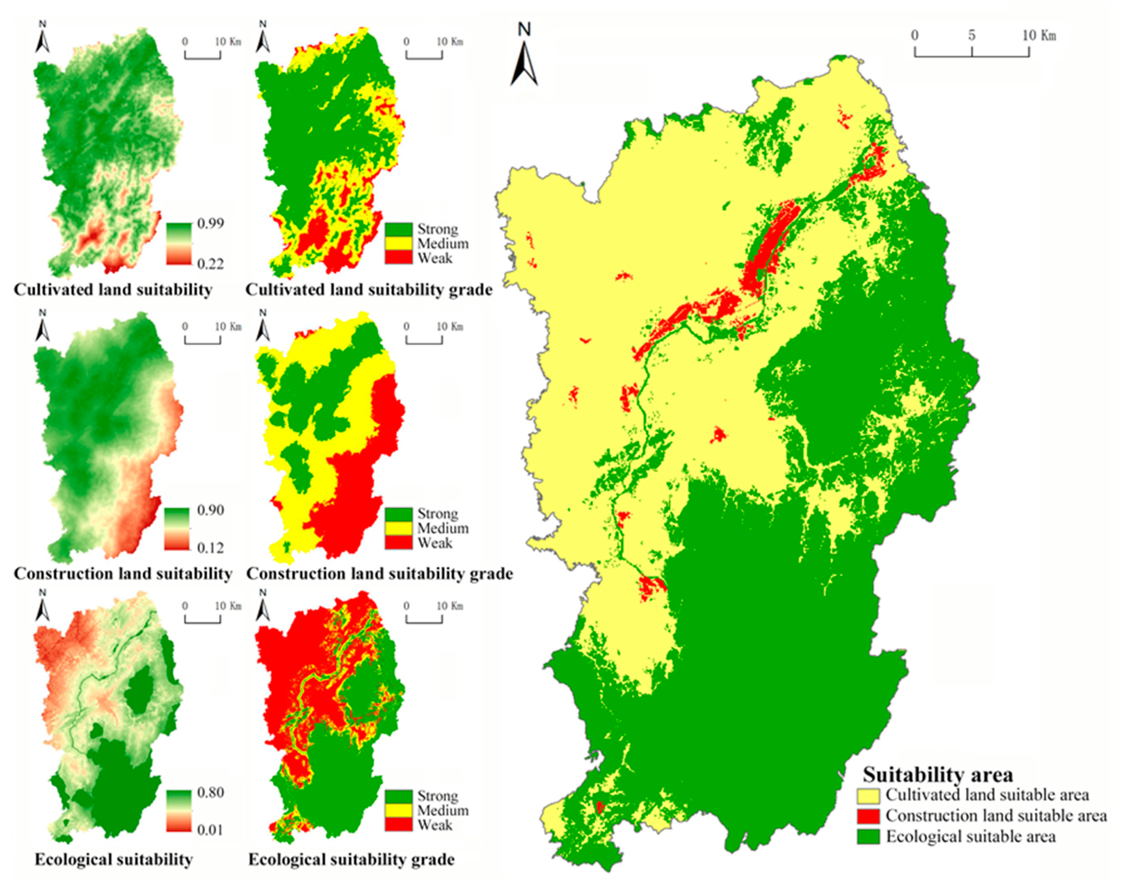
4.1. Spatial Distribution of Suitable Land Types

Based on the different types of conflicts and combining the data accessibility of Jiangshan, this study utilized the differentiation index (Appendix A, Table A2, Table A3 and Table A4) to analyze the reference basis of the different boundary delimitations and the types and characteristics of boundary conflicts. The factors based on the scale of the spots should be selected when spots are used as the object of evaluation, and the factors that can reflect the neighborhood in the conflict spots into the evaluation index system should be considered. Through comprehensively analyzing the restrictive, suitability, and neighboring influencing factors, the comprehensive index of the land suitability for various land types in Jiangshan natural reserves was calculated. In addition, the suitable land types for the conflict spots were qualitatively evaluated, using the corresponding discrimination matrix of the conflict spot (Table 4) to generate the land distribution maps (Figure 4). “Strong”, “medium”, and “weak” in Figure 4 were determined by the natural breakpoint method.

4.2. Preliminary Candidate Range for Reserves

On the basis of the specific situation of Jiangshan natural reserves and the data availability, the forestry survey unit was selected as the basic statistical unit (Figure 5) to classify or grade the geomorphological, soil, and vegetation conditions of each unit. The geomorphological conditions include the topography, slope grade, aspect, and slope position (Figure 6); the soil conditions comprise the soil thickness, soil name, and soil type (Figure 7); the vegetation conditions include the vegetation coverage, vegetation average height, canopy density, average breast diameter, density, tree age, and tree species structure (Figure 8). The values are assigned from low to high according to the grading of each feature of the resource background. The average values of the background features of PIN and POUT are calculated, Table 4 reports the statistical results. Figure 9 displays the candidate range of the protected sites for the new screening (C1).

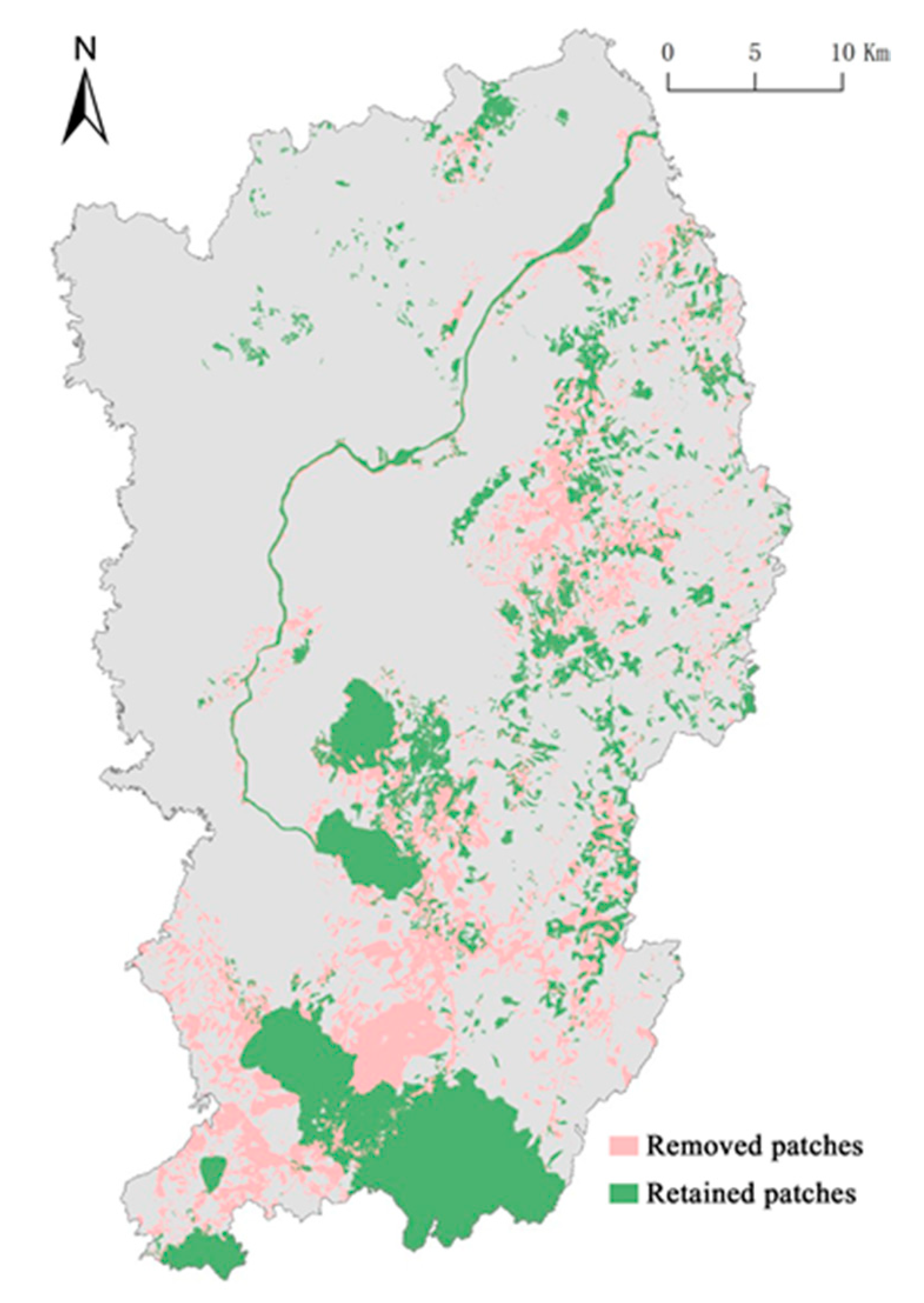
4.3. Results of the Secondary Optimization of the Candidate Range of Reserves

The distribution map of natural and cultural landscape resources is generated according to the general planning text of Jianglang Mountain protected area. Natural landscape resources correspond to meteorological diversity scenery, geological landscape, hydrologic scenery, biology landscape, and geological environment protection area. Meteorological diversity scenery mainly includes sun, moon, stars, snow, clouds, natural sound, and image. The geological landscape is a geological and geomorphic landscape. Hydrologic scenery mainly refers to spring, stream, lake, and lake falls. Biological landscape includes all kinds of flora and fauna landscapes. Cultural landscape resources, including the elements, such as the specialties (e.g., folk customs, crafts, and products) and historical sites and buildings in the protected areas. The spots with important ecological value and ecological security are extracted from the forest survey data (Figure 10), which include the areas with a forest coverage of greater than 65, highest protection level, complete community structure, and important water sources. After the above elements and the previously delineated protected land boundary with the candidate range C1 were merged, the new screening range C2 was obtained through intersecting the area with complete species community structure (Figure 11).

4.4. Tertiary Optimization to Form a New Reserve

The spots mentioned in the previous subsection were connected and coordinated with the other existing construction control conditions, and the current land-use-status information of the candidate range C2 of the reserve was assessed to remove the patches; such information includes the urban or construction town land, village land, hydraulic construction land, tea garden and orchard land, mining land, private land of forest rights, river roads, and administrative areas. Figure 12 and Figure 13 depict the screening process of the surrounding spots of the existing reserves in Jiangshan and a sample scope of the newly formed natural protection areas. The area of the new reserve is 150.524 km2, which is 6.682 km2 bigger than the original one.
It can be seen from the comparison that the original Fugai Mountain Provincial Geopark covers an area of about 9.41 km2, which overlaps with the Fugai Mountain Provincial Geopark within the scope of Jianglang Mountain National Park. It also has high similarity in the composition of scenic resources and biological resources. Combined with the principle of giving priority to protection intensity at the same level, low levels at different levels obey high levels. The original Jiangshan Fugai Mountain Provincial Geopark should be included in the scope of Jianglang Mountain National Park and integrated with the Fugai Mountain Provincial Geopark in Jianglang Mountain National Park. The Fugai Mountain area of the original Xianxialing Natural Reserve, with an area of about 7.81 km2, overlaps with the Fugai Mountain Provincial Geopark within the Jiangshan Fugai Mountain Provincial Geopark and the original Jiangshan Fugai Mountain Provincial Geopark in a large area, and it should be included in the Jiangshan Fugai Mountain Provincial Geopark and integrated with the Fugai Mountain Scenic spot in the Jianglang Mountain National Park.

5. Discussion

5.1. Comparison with Other Delineation Techniques for Reserves

Boundary issues play a key role in the study of natural reserves. However, few studies have discussed the boundary of natural reserves; the academic interest is mainly focused on the boundaries in the field of landscape ecology. Moreover, the systematic boundary delimitation methods for nature reserves are lacking. The study of the conservation regionalization that focuses on regional biodiversity conservation is relatively mature and includes conservation vacancy analysis, conservation priority area analysis, and ecological conservation planning.
The vacancy analysis for the biodiversity of reserves applies layer superposition and iteration methods [35] to determine the conservation gap. These approaches involve superposing the built reserves and the survey data of specific species, vegetation, and natural ecosystem type distribution or using a species distribution [36], habitat suitability [37], and other mathematical models [38] to guide the scientific layout of natural reserves. At present, numerous vacancy analyses for reserves remain confined to a part of the national key protected species or limited types of ecosystem protection, which is unfavorable for establishing an entire policy set to strengthen the comprehensive analysis. In this study, the detailed data that provided a basis for the subsequent quantitative analysis were obtained from multiple channels. Consequently, the investigation is no longer limited to the protection of a single species, because, through the overall analysis of the regional ecosystem, along with the heritage resources and construction control conditions, the small-scale and precise analysis on the boundary demarcation of the natural reserve was conducted.
The quantitative analysis of the conservation priority area was conducted on the basis of the data of biodiversity and threats [39]. The determination of the conservation priority area is generally indicated by biodiversity hotspots or species with a high indicator [40,41], because the distribution information of the existing species is mostly based on the administrative units for statistics. In addition, as the primary means of resource allocation and protection decision-making [42], the administrative unit is highly conducive to the development of the protection plan. In related studies, the administrative unit was used to determine the protection priority area [43]. However, previous reports revealed that the administrative unit lacks ecological significance, and the priority area determined on the basis of the biogeographic unit is more representative than the administrative unit. Therefore, the combination of the administrative and biogeographic units should be used to identify the protection priority area and optimize the reserve system. The division of the priority areas of landscape protection is based on the objective ecosystem vulnerability, which has a different emphasis from the evaluation standard [44], and thereby yielding spatial overlap and challenges for generating a unified zoning plan [45]. This study constructed the C-NHC framework from the national policy level to screen the preliminary candidate areas for the reserves, organically integrated the administrative and natural geographic units, and established a scientifically unified spatial evaluation standard for reserves.
The ecological zone protection planning was performed on the basis of biogeographical zoning and related protection planning. Biogeographical zoning is a widely used technique for delineating natural reserve boundaries [46]. In the existing studies, the land is divided according to the ecological relationship between adjacent ecosystems [47]. A global zoning scheme based on biological groups, such as global biota types [20], world eco-regionalization [48], and biodiversity-based biogeographic regionalization framework [21], was also proposed. The conservation value of the biodiversity in nature reserves was quantitatively evaluated from three aspects, namely, ecosystem, species diversity, and genetic germplasm resource, through overlay analysis, TWINSPAN classification, and vacancy analysis for reserves based on spatial distribution data (e.g., landform, vegetation, and natural reserve for integrated geographical regionalization of natural protection). All of these methods presented satisfactory results and patterns. Similar to the conservation priority areas, inconsistent zoning standards will lead to different geographic zoning schemes, which will affect the protection decisions. Therefore, a unified judgment standard was established in this study through the construction of a quantifiable evaluation index system, which lays the foundation for boundary demarcation and scientific management of natural reserves.
The existing studies on nature reserve boundaries involve many aspects, such as protection objectives, habitat quality, and protection strategies (Table 5) [49,50]. In this study, natural disturbance mechanisms, climate change, habitat quality, and connectivity were incorporated as delineation criteria [51,52]. However, many deficiencies remain present in natural protection zoning plans based on biodiversity data, ecosystem status [53], and environmental quality [54,55]. In practice, the phenomenon of cross-integration occurs, which is limited to a single level of ecological protection and fails to address the conflicting interest demands of different social groups, as well as the confrontation and conflict in various land use modes. This study integrated three aspects namely, natural resource background, heritage resource characteristics, and construction control conditions, to optimize the boundaries of natural reserves. On the basis of regional ecological protection, the optimized boundaries of reserves are used to alleviate the conflict between the development and protection of natural reserves, which is beneficial in solving the problem regarding the spatial overlap of reserves. Thus, a scientific demarcation of natural reserves is generated.

5.2. Comparison with Traditional Border Demarcation Techniques for Chinese Reserves

China has not yet established a polished national park system. All types of natural reserves have been managed through special regulations, in which most of the discussions on the boundaries of natural reserves focus on scenic spots. The establishment of scenic spots involves the source of scenery and ecological protection, continuation of the historical context, coordination of protection plans, and utilization and management of multi-layered goals. The original demarcation methods for such spots include the equidistant control method of parallel moving road and river center line, terrain method on the basis of the contour line of mountain ridges, scenic-spot control method guided by scenery source, and coordination method involving relevant planning boundaries (Table 6). However, such techniques face several disadvantages. When demarcating the boundary, the landscape resources are not specified, thereby disregarding important factors, as well as lack of organization and accuracy. In recent years, scholars have proposed an element-based spatial analysis method based on delineating the boundaries of scenic spots by using overlapping and buffer analyses. The system for boundary demarcation comprises the classification of elements and the superposition of effective organizations, which is based on the concretization of the landscape resources into elements (e.g., survey data, natural resources, human economy, facilities and basic engineering conditions, and land and other materials). At the micro-level, the boundary is drawn by using the “terrain method” and evaluated and adjusted by using the elements. The element-based demarcation of natural reserves is easy to execute, and the weight assignment of the elements involves subjective components, thereby affecting the grasp on the overall characteristics. However, given the diversity in the types of scenic spots, no universal factor-classification system has been established.
At present, the boundary delineation of nature reserves adopts the spatial analysis technology in geographic information systems (GISs) to classify lands with high precision. Compared with a pure qualitative evaluation, the quantitative processing of each evaluation index, using the GIS technology, is more objective and is equipped with an index system that can be easily applied in the study area [56]. Moreover, the relevant methods for visual landscape evaluation are based on perspective (e.g., field of view and viewing distance). Imaging methods are used to extend the boundary demarcation results to three dimensions [57]. However, the boundary delineation of natural reserves involves technical, economic, legal, and even political decision-making, while some of them can hardly be controlled by planning and design institutions. Therefore, in-depth studies on the influence of laws, regulations, and government decisions should be conducted.
The construction of the pilot areas of national parks in China should rely on the original multi-type protection lands [58]. However, the general inheritance of the original boundaries and zones is inconsistent with the protection objectives of the authenticity and integrity of the ecosystem. Consequently, the influence of the existing land-use patterns on the realization of the protection objectives and community economic development is disregarded [59]. The existing studies propose a combination of resource and environment, landscape source value, and boundary overlap assessments [60] to classify, overlay, evaluate [61], and define the boundary of the reserve. The C-NHC framework considers the influence of the policies and regulations on the boundaries of natural reserves. The proposed framework comprehensively evaluates the requirements of the ecological land, cultivated land, and urban development of the conflict spots through building a quantifiable evaluation index system and subsequently constructs a unified evaluation standard that lays a foundation for the formulation of the collaborative optimization scheme for boundary conflicts. This study performed triple optimizations of the boundary of nature reserves based on the characteristics of the resource background, heritage resources, and construction control conditions. Moreover, following the previous studies, the proposed framework conducted the following: it integrated the ecological factors; established the scenery sources, construction management conditions, and other important factors of protected areas; and supplemented the previous relatively single and one-sided boundary delimitation methods of protected areas. These conditions aimed to introduce the boundary delimitation methods that can be implemented, popularized, and replicated.

5.3. Policy Enlightenment of Optimizing Boundary for Protected Areas

5.3.1. Standardized Boundary Demarcation Technology of Protected Areas Will Boost the Construction of Protected Area Systems

The boundary delineation of protected areas is not only technical delineation, but also includes economic, legal, and even political decisions. Some factors are beyond the control of planning and design institutions. Thus, in-depth research on the impact of relevant laws, regulations and government decisions is needed. If we only focus on the boundary of the protected area itself, then understanding the complete logical relationship between the boundary generation and the boundary information expression of the protected area fully is impossible. From the influence of ideology and policy system on the construction concept of natural protected areas to the special protection planning and land-use policy formulated by government departments, inextricably logical links are found between them and the boundary information of natural protected areas.
To establish a protected area system that is universally recognized by the international community, the effectiveness of boundary planning must be protected by legislation. The introduction of the Guiding Opinions in 2019 has clarified the direction for solving outstanding problems, such as overlap, multi-head management, unscientific classification, and unreasonable scope of protected areas in China, and opened a new chapter in the modern management of protected areas. However, specific implementation measures have not been clarified yet. How are guidelines implemented? How are boundaries integrated, merged, and adjusted from the most urgent and most controversial issues in the current reform of protected areas?
The boundary delineation method proposed in this study standardizes the integration and merging modes of various protected areas and strives to ensure the effectiveness and stability of the boundaries of the protected areas from the institutional level, thereby also eliminating the differences among different departments, regions, and management systems. This method will also promote the introduction of the special legislation protection of the boundary of natural conservation areas. In the sense of political geography that is highly unified between national sovereignty and the governance of protected areas, the boundary delineation method clears institutional obstacles for the creation of a complete system of protected areas in the entire territory of China.

5.3.2. Boundary of Protected Areas Will Become an Important Part of Land Spatial Layout Optimization

The demarcation of natural reserve boundaries is a key link in the construction of natural reserve system. In the process of the rapid urbanization worldwide, natural reserve boundaries play an increasingly important role in the protection of natural resources. As a means to coordinate the protection and development of nature, realizing the protection and sustainable use of natural resources is also helpful. However, in the actual implementation process, the lack of relevant theoretical system and the limitation of technical means will cause the boundary demarcation of natural protected areas to lack scientific basis and a clear quantitative system, thus resulting in an inaccurate boundary demarcation.
Uneven spatial data distribution, weak data base, low data integrity, and insufficient information sharing are all technical barriers to the boundary demarcation of natural protected areas in the early years that affect the scientific setting and layout of natural protected areas. With the advent of the information age, the rapid development of satellite remote-sensing data and GIS and GPS technologies has laid a solid foundation for the demarcation of refined and scientific natural protection boundaries. The improvement of technological level will inevitably be accompanied by the continuous improvement of standards, and the connotation of the boundaries of protected areas has also changed from a purely natural resource control boundary to the bottom line of the national land spatial planning.
The CPC Central Committee and the State Council issued several Opinions on Establishing a Land Spatial Planning System and Supervising its Implementation, thereby requiring the special plans for the protected areas to be closely linked with relevant land spatial planning and checked against “in one map” during the compilation and review processes. The construction of natural protected land system and the land spatial planning system will be connected and coordinated in the form of space scope and realize fine management. Based on the aforementioned requirements, the research begins from stating the objectives, criteria, and indicators for the delimitation of the protected area boundaries. Subsequently, the suitability of ecological, cultivated land, and construction land for all map spots in the region are evaluated. The evaluation results lay the foundation for the formulation of the coordinated optimization plan for border conflicts and provide a scientific basis for coordinating various types of land use in the preparation of land-use planning and prevention and reduction of actual land-use conflicts. This research is of great significance for realizing the orderly layout of the three types of space, including towns, agriculture, and ecology, which is also important for the optimization of the national spatial layout.

5.3.3. Delimiting the Scientific Boundaries of Protected Areas Is the Key to Improving the Management of Protected Areas

The space superposition problem of protected areas caused by multiple international designated areas is the key to restricting the effective management of protected areas. (1) Unreasonable boundaries of protected areas will lead to the serious fragmentation of protected areas and decentralization of departmental functions, which will intensify the fragmentation and islanding of protected area. (2) The staggered boundaries of natural protected areas also inevitably lead to the fuzzy management target boundaries of protected areas, which results in the unclear positioning of all kinds of protected areas in the management and causes difficulty in carrying out targeted management. (3) The unclear boundaries between the powers and responsibilities of various departments in the multiple international designated area will cause problems, such as indistinct management objectives, unclear responsibilities, and disordered management policies.
The boundary of natural protected areas is mainly used to define the authority of management. A reasonable boundary must contain the core value of natural resources and must not cause difficult coordination problems due to the large scope to serve the work of conservation management, rational utilization, and planning and implementation better. The boundary demarcation of protected areas, as a means of space control, can promote the improvement of the management level of protected areas from two aspects: one is to define the protection objectives, and the other is to balance the interests of multiple parties. (1) To clarify the protection objective, determining the protection object, the urgency, the main means, and the effect of protection and converting the protection objective into quantitative index are necessary. This study built a three-dimension (e.g., ecology, cultivated land, and construction) suitability evaluation index system that considers the ecological value, social economic security demand, and survival and judged the relationship between protection targets on the basis of defining a single protection target. The boundary demarcation based on the above principles is of great significance for the effective identification of protection targets. (2) The ecosystem service value is the core of the protected area. Therefore, this study took the natural background as the core analysis element and then analyzes the influence of soft factors, such as heritage resource characteristic and existing construction control conditions on the designation of protected area, in detail. The coordination of stakeholders at the boundary can be achieved by integrating natural resource management into the social selection framework based on the understanding of the key characteristics of protected areas and the consideration of respect for indigenous and traditional knowledge. The control measures will be implemented in space to achieve the unification of the physical and control boundaries.
The protected areas’ boundary, which is based on the coordination of resource utilization and ecological protected areas, provides a basic guarantee for the establishment of institutional standards. In the practice of protected area construction, boundary demarcation should not be regarded as the establishment of geographical boundary. The boundary of protected area should be adjusted in time according to the change in economic development and protection target, and the boundary of protected area should be transformed into the control problem of coordinating the land-use mode, scale, and intensity of stakeholders to clarify the boundary of protected land as the basis of implementing the spatial control of protected land.

6. Summary and Conclusions

With the continuous improvement of international protection awareness, the number of protection organizations has dramatically increased, and they have promoted various reserve-naming methods under different objectives, purposes, and management requirements; thus, the phenomenon of overlapping reserves has prominently increased. Therefore, the demarcation of the boundaries of scientific and reasonable reserves has become the key to the effective management and sustainable development of natural reserves. The delineation of the boundaries of natural reserves provides a scientific basis for the formulation of regional ecological protective policies. As an effective tool for managing reserves, the boundaries serve as a bridge to alleviate the current conflicts between the development and protection of nature reserves, as well as a key factor and guarantee that play multiple functions in the implementation of an effective management.
Rebuilding the natural reserve system by using national parks as the main body is a crucial exploration in the construction of an ecological civilization system in China. On this basis, this study conducted an in-depth investigation of the technical methods for delineating the spatial boundaries of natural reserves. Taking Jiangshan Nature Reserve as a case, the C-NHC framework was constructed, and the boundaries of the new reserves were delineated. First, the preliminary candidate areas of the reserve were selected. Second, a comprehensive vector evaluation was performed on the basis of the background characteristics of the resources, heritage resource characteristics, and construction management conditions. Third, resource background evaluation and initial aggregation optimization were executed, the existing elements of the reserve were extracted, and the resource-based clustering results were intersected and optimized. Lastly, the existing construction management conditions were connected and coordinated to form a scientific, reasonable, and clear boundary of the nature reserves. Through the quantitative evaluation of the conflict patches and the triple optimization of the boundary of the reserve, this study has changed the status quo of the spatial overlap of the reserve, which is considerably important in the improvement of the planning and management of natural reserves and establishment of a unified management authority.
This study utilized geographic information technology, and the protection area boundaries were optimized on the basis of three dimensions (i.e., resource background characteristics, heritage resource characteristics, and construction management conditions). The newly delineated boundaries play a key role in coordinating the construction and development of Jiangshan and the ecological environment protection, restoring and improving the service functions of the regional natural ecosystems, and ensuring the sustainable use of resources. This study will exert an extensive influence on the in-depth analysis of the spatial pattern of natural reserves in the future, improvement of the planning and management, and overall promotion of the construction of natural reserves. This technical framework can provide a useful reference for the boundary delimitation of nature reserves in China and even the world. This study also has some limitations. We did not provide a method for selecting the appropriate restrictive suitability neighborhood influence factors and characteristics of the heritage resources in different study areas. When our methods are used in different study areas, researchers are still required to select the elements to participate in the study, a process that is vulnerable to great subjectivity.
Although China has formulated numerous planning and management schemes, the current natural reserve system remains limited, given the prominent overlapping phenomenon, which hinders the scientific construction and management of the natural reserves. As China continues to promote a “national park-based nature reserve system”, natural protection zones that can precisely reflect the characteristics of the regional natural resources and construction conditions should be developed to provide a basis for the construction and management of the natural protection land. To solve the serious problems and contradictions in the management of the natural reserves in the country, the proposed boundary delimitation method has re-integrated all types of natural reserves and established a scientific spatial pattern of natural reserves. We believe that the construction management conditions have the greatest impact on the final results. The proposed method can enhance the management system; solve relevant problems (e.g., multi-head management); and promote a highly systematic, integrated, and collaborative natural reserve system.

Author Contributions

Conceptualization, H.G.; methodology, H.G.; software, Y.W.; validation, Y.W.; formal analysis, Y.W.; investigation, Y.W.; resources, H.G.; data curation, H.G.; writing—original draft preparation, Y.W.; writing—review and editing, Y.L.; visualization, Y.W.; supervision, Y.D.; project administration, H.G.; funding acquisition, H.G. All authors have read and agreed to the published version of the manuscript.

Funding

This work was supported by the Social Science Fund of Zhejiang Province (21NDJC034YB), and Centre for Balance Architecture, Zhejiang University (2021-KYY-669000-0014).

Institutional Review Board Statement

Not applicable.

Informed Consent Statement

Not applicable.

Data Availability Statement

Not applicable.

Acknowledgments

The authors wish to thank anonymous reviewers for their valuable comments and suggestions for improving the quality of this paper.

Conflicts of Interest

The authors declare no conflict of interest.

Appendix A

Table A1. Discriminant matrix of suitable land use.
Type CodeLand Suitability CombinationAppropriatelyLand Use Adjustment Instructions
Suitability of Construction LandSuitability of Cultivated LandSuitability of Ecological Land
1HighHighHighEcological land, cultivated landThe three types of land are suitable. When conflicting with ecological land, the principle of natural reserves should be followed to maintain the original ecological land. When there is no conflict of ecological land, considering that cultivated land also has certain ecological service value, the original cultivated land should be maintained.
2HighHighLowConstruction land and cultivated landBoth construction land and agricultural land are suitable areas. Due to the obvious comparative advantages of construction land and the low urgency of ecological protection, it is more likely that cultivated land will be converted to construction land. Consider conversion to construction land. When there is no conflict in regard to construction land, maintain or convert to cultivated land.
3HighMediumHighEcological land, construction landThe suitability of ecological land and construction land is very strong, because construction land has obvious comparative advantages and the possibility of expansion of construction land is high, but the principle of nature protection should be considered, so maintenance or conversion to ecological land should be considered. It can be converted into construction land when there is no conflict in regard to ecological land.
4HighMediumLowConstruction land and cultivated landConstruction land has obvious advantages and high expansion potential; thus, it can be considered to be converted to construction land. It is maintained or converted to cultivated land when there is no conflict in regard to construction land.
5HighLowHighEcological land, construction landThe suitability of ecological land and construction land is very strong, because the comparative advantage of construction land is obvious; the possibility of construction land expansion is high, but the principle of natural protection should be considered, so it should be considered to maintain or transform into ecological land; it can be considered to transform into construction land when there is no conflict in regard to ecological land.
6HighLowLowConstruction land and original landConstruction land has obvious advantages, and the possibility of expansion is high. It can be considered to be converted into construction land; when there is no conflict in regard to construction land, you can consider maintaining the original land type.
7MediumHighHighEcological land, cultivated landThe comparative advantages of construction land and ecological land are obvious, but following the principle of ecological priority, it can be considered to be converted into ecological land; when there is no conflict in regard to ecological land, it can be considered to be maintained or converted into cultivated land.
8MediumHighLowCultivated land, construction landCultivated land has obvious advantages, and the original cultivated land should be maintained; when there is no conflict of cultivated land, it can be considered to be converted into construction land.
9MediumMediumHighEcological land, cultivated landThe ecological land maintenance capability is strong, and the original ecological land should be maintained; when there is no ecological land conflict, the conversion into cultivated land should be considered according to the principle of priority of cultivated land protection.
10MediumMediumLowCultivated land, construction landThe maintenance capacity of ecological land is weak, and the suitability of construction land and cultivated land is equivalent, but the principle of priority of cultivated land protection should be followed, and the original cultivated land should be kept from encroaching as much as possible; when there is no conflict in regard to cultivated land, it can be considered to be converted into construction land.
11MediumLowHighEcological land, construction landEcological land has obvious advantages; when there is no conflict of ecological land, it can be considered to be converted to construction land.
12MediumLowLowConstruction land and original landDue to the comparative advantage of construction land, the possibility of maintaining or converting land into construction land is high; when there is no conflict between construction land, consider maintaining the original land type.
13LowHighHighFierce conflictDue to the conflict between agricultural land and ecological land, the possibility of expansion of construction land is low; due to the comparative advantage of agricultural land output rate and the shortage of agricultural land resources in the region, the possibility of conversion of suitable unused agricultural land to agricultural land is high, but the possibility of conversion is determined by the comparison of two kinds of policies: agricultural land and ecological land.
14LowHighLowWeak conflictCultivated land has obvious advantages and should be maintained or reclaimed as cultivated land.
15LowMediumHighEcological land, cultivated landEcological land has obvious advantages. The original ecological land should be maintained, or the land consolidation should be considered as ecological land; when there is no ecological land conflict, it should be maintained or converted into cultivated land for type 8 or 9.
16LowMediumLowArable land, original landThe suitability of cultivated land is high, and the land should be maintained or converted into cultivated land; when there is no conflict of cultivated land, the original land type should be maintained.
17LowLowHighEcological land, original land typeEcological land has obvious advantages, so we should maintain the original ecological land or consider returning farmland or land consolidation to ecological land; when there is no conflict in regard to ecological land, maintain the original land type.
18LowLowLowCurrent statusIt is more likely to maintain the status quo of land use.
Table A2. Ecological Suitability Evaluation Index.
TargetGuidelinesFactorElement
Evaluation of the importance of ecological function and competitivenessWater conservation, soil and water conservation area, sand prevention, and sand fixation areaNatural conditionsVegetation factorVegetation coverage
Vegetation cover type
Terrain factorSlope
Slope position
Slope length
Soil factorSoil texture
Soil thickness
Natural location factorDistance from river
Distance from lakes and reservoirs
Distance from pit
Distance from existing delineated reserve and ecological red line
Landscape patternPlaque characteristicsPlaque size
Plaque shape index
Plaque aggregation degreeDegree of aggregation
Separation
Biodiversity ReserveNatural conditionsResource statusSurface cover type
Water network density
Vegetation coverage
Species distributionSpecies diversity
Species rarity
Species distribution concentration
Habitat nature
Landscape patternPlaque characteristicsPlaque size
Plaque shape index
Plaque aggregation degreePlaque fragmentation
Patchy landscape diversity
Network connectivityPlaque centrality
Median Index
Correlation length index
Table A3. Cultivated Land Suitability Evaluation Index.
TargetGuidelinesFactorElement
Cultivated land suitability evaluationRestrictive factorsPlanning factorsWhether it is in a nature reserve
Is it located in the forest park
Whether it is located in a national scenic spot
Whether it is located in the primary and secondary water source protection zone
Whether it is located in the returned forest area
Natural conditionsWhether the slope is greater than 15°
Suitability factorFarming conditionsSlope
Soil organic matter content
Surface soil thickness
Location factorDistance from road
Distance from river
Distance from the reservoir
Distance to nearest village
Planning factorsWhether the current land is cultivated land
Cultivated land conversion cost
Geometric FeaturesPatch size
Patch shape index
Influencing factors of neighborhood The largest area in the buffer zone
The largest perimeter in the buffer zone
Proportion of cultivated land area in the buffer zone
Patch density of cultivated land in the buffer zone
Plaque aggregation degree of buffer farmland
Table A4. Construction Land Suitability Evaluation Index.
TargetGuidelinesFactorElement
Construction land suitability evaluationRestrictive factorsPlanning factorsWhether it is in a nature reserve
Whether it is located in the forest park
Whether it is located in a national scenic spot
Whether it is located in the primary and secondary water source protection zone
Whether it is located in the basic farmland protection area
Natural conditionsWhether it is an area with frequent natural disasters
Suitability factorUrban construction conditionsSlope
Elevation
Terrain relief
Location factorDistance from road
Distance from river
Distance from the reservoir
Distance from main city
Planning factorsWhether the current land is construction land
Construction and development costs
Geometric FeaturesPatch size
Patch shape index
Influencing factors of neighborhood The largest area in the buffer zone
The largest perimeter in the buffer zone
Proportion of existing construction land area in the buffer zone
Plaque density of construction land in the buffer zone
Plaque aggregation degree of buffer construction land

References

  1. DeFries, R.S.; Foley, J.A.; Asner, G.P. Land-Use Choices: Balancing Human Needs and Ecosystem Function. Front. Ecol. Environ. 2004, 2, 249–257. [Google Scholar] [CrossRef]
  2. Nogués-Bravo, D.; Araújo, M.B.; Romdal, T.; Rahbek, C. Scale Effects and Human Impact on the Elevational Species Richness Gradients. Nature 2008, 453, 216–219. [Google Scholar] [CrossRef] [PubMed] [Green Version]
  3. Orme, C.D.L.; Davies, R.G.; Burgess, M.; Eigenbrod, F.; Pickup, N.; Olson, V.A.; Webster, A.J.; Ding, T.-S.; Rasmussen, P.C.; Ridgely, R.S. Global Hotspots of Species Richness Are Not Congruent with Endemism or Threat. Nature 2005, 436, 1016–1019. [Google Scholar] [CrossRef]
  4. Liu, Y.B.; Li, R.D.; Song, X.F. Analysis of Coupling Degrees of Urbanization and Ecological Environment in China. J. Nat. Res. 2005, 20, 105–112. [Google Scholar]
  5. Grimm, N.B.; Foster, D.; Groffman, P.; Grove, J.M.; Hopkinson, C.S.; Nadelhoffer, K.J.; Pataki, D.E.; Peters, D.P. The Changing Landscape: Ecosystem Responses to Urbanization and Pollution across Climatic and Societal Gradients. Front. Ecol. Environ. 2008, 6, 264–272. [Google Scholar] [CrossRef] [Green Version]
  6. Schulze, E.-D.; Mooney, H.A. Biodiversity and Ecosystem Function; Springer Science & Business Media: Cham, Switzerland, 2012. [Google Scholar]
  7. Balmford, A.; Green, R.E.; Jenkins, M. Measuring the Changing State of Nature. Trends Ecol. Evol. 2003, 18, 326–330. [Google Scholar] [CrossRef]
  8. Groombridge, B.; Jenkins, M.D. Global Biodiversity: Earth’s Living Resources in the 21st Century; World Conservation Press: Cambridge, UK, 2000. [Google Scholar]
  9. Pinheiro, J. Parks for Biodiversity Policy Guidance Based on Experience in ACP Countries; IUCN: Gland, Switzerland, 1999. [Google Scholar]
  10. Dudley, N. Guidelines for Applying Protected Area Management Categories; IUCN: Gland, Switzerland, 2008. [Google Scholar]
  11. Deguignet, M.; Juffe-Bignoli, D.; Harrison, J.; MacSharry, B.; Burgess, N.D.; Kingston, N. United Nations List of Protected Areas; UNEP-WCMC: Cambridge, UK, 2014. [Google Scholar]
  12. Borrini-Feyerabend, G.; Bueno, P.; Hay-Edie, T.; Lang, B.; Rastogi, A.; Sandwith, T. A Primer on Governance for Protected and Conserved Areas. In Proceedings of the Stream on Enhacing Diversity and Quality of Governance, 2014 IUCN World Parks Congress; IUCN: Gland, Switzerland, 2014. [Google Scholar]
  13. Finke, G. Linking Landscapes: Exploring the Relationships between World Heritage Cultural Landscapes and IUCN Protected Areas. In IUCN World Heritage Study; IUCN: Gland, Switzerland, 2013; Volume 11. [Google Scholar]
  14. Osipova, E.; Shadie, P.; Zwahlen, C.; Osti, M.; Shi, Y.; Kormos, C.; Bertzky, B.; Murai, M.; Van Merm, R.; Badman, T. IUCN World Heritage Outlook 2: A Conservation Assessment of All Natural World Heritage Sites; IUCN: Gland, Switzerland, 2017; Volume 92. [Google Scholar]
  15. Zhao, Z.C.; Peng, L.; Yang, R. Reconstruction of Protected Area System in the Context of the Establishment of National Park System in China. Chin. Landsc. Archit. 2016, 7, 11–18. [Google Scholar]
  16. Jim, C.Y.; Xu, S.S. Recent Protected-Area Designation in China: An Evaluation of Administrative and Statutory Procedures. Geogr. J. 2004, 170, 39–50. [Google Scholar] [CrossRef]
  17. Chen, S.-B.; Jiang, G.-M.; Ouyang, Z.-Y.; XU, W.-H.; Xiao, Y. Relative Importance of Water, Energy, and Heterogeneity in Determining Regional Pteridophyte and Seed Plant Richness in China. J. Syst. Evol. 2011, 49, 95–107. [Google Scholar] [CrossRef]
  18. Arponen, A.; Heikkinen, R.K.; Thomas, C.D.; Moilanen, A. The Value of Biodiversity in Reserve Selection: Representation, Species Weighting, and Benefit Functions. Conserv. Biol. 2005, 19, 2009–2014. [Google Scholar] [CrossRef]
  19. Tang, X. Analysis of the Current Situation of China′ s Nature Reserve Network and a Draft Plan for Its Optimization. Biodivers. Sci. 2005, 13, 81. [Google Scholar] [CrossRef]
  20. Prentice, I.C.; Cramer, W.; Harrison, S.P.; Leemans, R.; Monserud, R.A.; Solomon, A.M. Special Paper: A Global Biome Model Based on Plant Physiology and Dominance, Soil Properties and Climate. J. Biogeogr. 1992, 19, 117–134. [Google Scholar] [CrossRef]
  21. Kreft, H.; Jetz, W. A Framework for Delineating Biogeographical Regions Based on Species Distributions. J. Biogeogr. 2010, 37, 2029–2053. [Google Scholar] [CrossRef]
  22. Alberts, H.C.; Hazen, H.D. Maintaining Authenticity and Integrity at Cultural World Heritage Sites. Geogr. Rev. 2010, 100, 56–73. [Google Scholar] [CrossRef]
  23. Unesco. Recommendation Concerning the Preservation of Cultural Property Endangered by Public or Private Works 19 November 1968. Available online: http://portal.unesco.org/en/ev.php-URL_ID=13085&URL_DO=DO_TOPIC&URL_SECTION=201.html (accessed on 1 December 2021).
  24. Gullino, P.; Larcher, F. Integrity in UNESCO World Heritage Sites. A Comparative Study for Rural Landscapes. J. Cult. Herit. 2013, 14, 389–395. [Google Scholar] [CrossRef]
  25. Jokilehto, J. Considerations on Authenticity and Integrity in World Heritage Context. City Time 2006, 2, 1. [Google Scholar]
  26. Wells, M.; Brandon, K.; Hannah, L. People and Parks: Linking Protected Area Management with Local Communities; World Bank: Washington, DC, USA, 1992. [Google Scholar]
  27. Margules, C.R.; Pressey, R.L. Systematic Conservation Planning. Nature 2000, 405, 243–253. [Google Scholar] [CrossRef] [PubMed]
  28. Jones, K.R.; Venter, O.; Fuller, R.A.; Allan, J.R.; Maxwell, S.L.; Negret, P.J.; Watson, J.E. One-Third of Global Protected Land Is under Intense Human Pressure. Science 2018, 360, 788–791. [Google Scholar] [CrossRef] [PubMed] [Green Version]
  29. Sannigrahi, S.; Chakraborti, S.; Joshi, P.K.; Keesstra, S.; Sen, S.; Paul, S.K.; Kreuter, U.; Sutton, P.C.; Jha, S.; Dang, K.B. Ecosystem Service Value Assessment of a Natural Reserve Region for Strengthening Protection and Conservation. J. Environ. Manag. 2019, 244, 208–227. [Google Scholar] [CrossRef] [PubMed]
  30. Al-Harbi, K.M.A.-S. Application of the AHP in Project Management. Int. J. Proj. Manag. 2001, 19, 19–27. [Google Scholar] [CrossRef]
  31. Bunruamkaew, K.; Murayama, Y. Land Use and Natural Resources Planning for Sustainable Ecotourism Using GIS in Surat Thani, Thailand. Sustainability 2012, 4, 412–429. [Google Scholar] [CrossRef] [Green Version]
  32. Yu, K.; Guo, G.-D.; Li, J.; Lin, S. Quantum Algorithms for Similarity Measurement Based on Euclidean Distance. Int. J. Theor. Phys. 2020, 59, 3134–3144. [Google Scholar] [CrossRef]
  33. Silverman, H. Heritage and Authenticity. In The Palgrave Handbook of Contemporary Heritage Research; Springer: Cham, Switzerland, 2015; pp. 69–88. [Google Scholar]
  34. Xu, J.; Chen, L.; Lu, Y.; Fu, B. Local People’s Perceptions as Decision Support for Protected Area Management in Wolong Biosphere Reserve, China. J. Environ. Manag. 2006, 78, 362–372. [Google Scholar] [CrossRef] [PubMed]
  35. Jennings, M.D. Gap Analysis: Concepts, Methods, and Recent Results. Landsc. Ecol. 2000, 15, 5–20. [Google Scholar] [CrossRef]
  36. Catullo, G.; Masi, M.; Falcucci, A.; Maiorano, L.; Rondinini, C.; Boitani, L. A Gap Analysis of Southeast Asian Mammals Based on Habitat Suitability Models. Biol. Conserv. 2008, 141, 2730–2744. [Google Scholar] [CrossRef]
  37. Hopton, M.E.; Mayer, A.L. Using Self-Organizing Maps to Explore Patterns in Species Richness and Protection. Biodivers. Conserv. 2006, 15, 4477–4494. [Google Scholar] [CrossRef]
  38. Peterson, A.T.; Kluza, D.A. New Distributional Modelling Approaches for Gap Analysis. In Animal Conservation Forum; Cambridge University Press: Cambridge, UK, 2003; Volume 6, pp. 47–54. [Google Scholar]
  39. Groves, C.R.; Jensen, D.B.; Valutis, L.L.; Redford, K.H.; Shaffer, M.L.; Scott, J.M.; Baumgartner, J.V.; Higgins, J.V.; Beck, M.W.; Anderson, M.G. Planning for Biodiversity Conservation: Putting Conservation Science into Practice: A Seven-Step Framework for Developing Regional Plans to Conserve Biological Diversity, Based upon Principles of Conservation Biology and Ecology, Is Being Used Extensively by the Nature Conservancy to Identify Priority Areas for Conservation. BioScience 2002, 52, 499–512. [Google Scholar]
  40. Brum, F.T.; Graham, C.H.; Costa, G.C.; Hedges, S.B.; Penone, C.; Radeloff, V.C.; Rondinini, C.; Loyola, R.; Davidson, A.D. Global Priorities for Conservation across Multiple Dimensions of Mammalian Diversity. Proc. Natl. Acad. Sci. USA 2017, 114, 7641–7646. [Google Scholar] [CrossRef] [Green Version]
  41. Dobson, A.P.; Rodriguez, J.P.; Roberts, W.M.; Wilcove, D.S. Geographic Distribution of Endangered Species in the United States. Science 1997, 275, 550–553. [Google Scholar] [CrossRef] [Green Version]
  42. Moilanen, A.; Arponen, A. Administrative Regions in Conservation: Balancing Local Priorities with Regional to Global Preferences in Spatial Planning. Biol. Conserv. 2011, 144, 1719–1725. [Google Scholar] [CrossRef]
  43. Yang, F.; Hu, J.; Wu, R. Combining Endangered Plants and Animals as Surrogates to Identify Priority Conservation Areas in Yunnan, China. Sci. Rep. 2016, 6, 30753. [Google Scholar] [CrossRef] [Green Version]
  44. Pimm, S.L.; Lawton, J.H. Planning for Biodiversity. Science 1998, 279, 2068–2069. [Google Scholar] [CrossRef] [Green Version]
  45. Brooks, T.M.; Mittermeier, R.A.; Da Fonseca, G.A.; Gerlach, J.; Hoffmann, M.; Lamoreux, J.F.; Mittermeier, C.G.; Pilgrim, J.D.; Rodrigues, A.S. Global Biodiversity Conservation Priorities. Science 2006, 313, 58–61. [Google Scholar] [CrossRef] [Green Version]
  46. Udvardy, M.D.; Udvardy, M.D.F. A Classification of the Biogeographical Provinces of the World; International Union for Conservation of Nature and Natural Resources Morges: Gland, Switzerland, 1975; Volume 8. [Google Scholar]
  47. Bailey, R.G.; Hogg, H.C. A World Ecoregions Map for Resource Reporting. Environ. Conserv. 1986, 13, 195–202. [Google Scholar] [CrossRef]
  48. Schultz, J. The Ecozones of the World: The Ecological Divisions of the Geosphere; Springer Science & Business Media: Cham, Switzerland, 2005. [Google Scholar]
  49. Kujala, H.; Moilanen, A.; Araujo, M.B.; Cabeza, M. Conservation Planning with Uncertain Climate Change Projections. PLoS ONE 2013, 8, e53315. [Google Scholar]
  50. Moilanen, A.; Laitila, J.; Vaahtoranta, T.; Dicks, L.V.; Sutherland, W.J. Structured Analysis of Conservation Strategies Applied to Temporary Conservation. Biol. Conserv. 2014, 170, 188–197. [Google Scholar] [CrossRef] [Green Version]
  51. Hodgson, J.A.; Moilanen, A.; Wintle, B.A.; Thomas, C.D. Habitat Area, Quality and Connectivity: Striking the Balance for Efficient Conservation. J. Appl. Ecol. 2011, 48, 148–152. [Google Scholar] [CrossRef]
  52. Leroux, S.J.; Rayfield, B. Methods and Tools for Addressing Natural Disturbance Dynamics in Conservation Planning for Wilderness Areas. Divers. Distrib. 2014, 20, 258–271. [Google Scholar] [CrossRef] [Green Version]
  53. Sharafi, S.M.; Moilanen, A.; White, M.; Burgman, M. Integrating Environmental Gap Analysis with Spatial Conservation Prioritization: A Case Study from Victoria, Australia. J. Environ. Manag. 2012, 112, 240–251. [Google Scholar] [CrossRef]
  54. Jenkins, C.N.; Joppa, L. Expansion of the Global Terrestrial Protected Area System. Biol. Conserv. 2009, 142, 2166–2174. [Google Scholar] [CrossRef]
  55. Cabeza, M.; Arponen, A.; Jäättelä, L.; Kujala, H.; Van Teeffelen, A.; Hanski, I. Conservation Planning with Insects at Three Different Spatial Scales. Ecography 2010, 33, 54–63. [Google Scholar] [CrossRef]
  56. Rui, H.Y.Y. Study on Boundary Cognizance of Famous Scenic Sites. Chin. Landsc. Archit. 2011, 27, 56–60. [Google Scholar]
  57. Theberge, J.B. Guidelines to Drawing Ecologically Sound Boundaries for National Parks and Nature Reserves. Environ. Manag. 1989, 13, 695–702. [Google Scholar] [CrossRef]
  58. Zhou, D.Q.; Edward Grumbine, R. National Parks in China: Experiments with Protecting Nature and Human Livelihoods in Yunnan Province, Peoples’ Republic of China (PRC). Biol. Conserv. 2011, 144, 1314–1321. [Google Scholar] [CrossRef]
  59. Saviano, M.; Di Nauta, P.; Montella, M.M.; Sciarelli, F. Managing Protected Areas as Cultural Landscapes: The Case of the Alta Murgia National Park in Italy. Land Use Policy 2018, 76, 290–299. [Google Scholar] [CrossRef]
  60. Sriarkarin, S.; Lee, C.-H. Integrating Multiple Attributes for Sustainable Development in a National Park. Tour. Manag. Perspect. 2018, 28, 113–125. [Google Scholar] [CrossRef]
  61. Habtemariam, B.T.; Fang, Q. Zoning for a Multiple-Use Marine Protected Area Using Spatial Multi-Criteria Analysis: The Case of the Sheik Seid Marine National Park in Eritrea. Mar. Policy 2016, 63, 135–143. [Google Scholar] [CrossRef]
Figure 1. AHP workflow for determining the weight of suitability factors.
Sustainability 14 00587 g001
Figure 2. Technical process.
Sustainability 14 00587 g002
Figure 3. (a) Distribution of Jiangshan natural reserves. (b) Overlap of Jiangshan natural reserves.
Sustainability 14 00587 g003
Figure 4. Delimitation of the candidate areas.
Sustainability 14 00587 g004
Figure 5. Basic statistical unit.
Sustainability 14 00587 g005
Figure 6. Geomorphological condition assessment.
Sustainability 14 00587 g006
Figure 7. Soil condition assessment.
Sustainability 14 00587 g007
Figure 8. Vegetation condition assessment.
Sustainability 14 00587 g008
Figure 9. Reserve candidate range C1.
Sustainability 14 00587 g009
Figure 10. Analysis of the reserve elements.
Sustainability 14 00587 g010
Figure 11. Reserve candidate range C2.
Sustainability 14 00587 g011
Figure 12. Screening of the spots around the reserve.
Sustainability 14 00587 g012
Figure 13. New delineated reserve.
Sustainability 14 00587 g013
Table 1. Referable elements for boundary optimization of protected areas.
First ClassSecond ClassThird ClassReferable Elements
Resource backgroundTopographical unitGeography and geomorphyElevation, slope, aspect, ridge line, valley line, river line, forest line, and snow line.
Geological conditionsStructural lines, faults, and seepage conditions.
Natural resource zoningHydrology conditionsRiver basin, drainage divide, water conservation area, big lake wetland patch, and groundwater protection zone.
Soil conditionsSoil zoning, soil thickness, and soil hardness.
Vegetation conditionsVegetation zoning, forest coverage, vegetation canopy density, stand structure, and tree age structure.
Heritage resource characteristicsEcosystem integrityEcosystem corridorMaterial energy connection channel of ecosystem.
Ecosystem patchEcological source, ecosystem fragile area, and ecosystem sensitive area.
Ecosystem matrixDistribution boundary of ecosystem.
Species diversitySpecies conservation patchDistribution density and habitat of key protected animals and plants (possibly seasonal).
Species conservation corridorMigration or retrogressive passage of key protected animals (possibly seasonal).
Community complexitySpecies richness and structural complexity differentiation.
Biological integrityIntegrity differentiation of various species, such as predator and human species.
Characteristic landscape relicsNatural heritage and landscape characteristicsNatural relics or natural landscape densely distributed areas, natural landscape connecting corridors, natural landforms, and landscape zoning.
Humanities landscape characteristicsCultural landscape densely distributed area, cultural landscape connecting corridor, and cultural ecological zoning.
Construction management conditionsConstruction management continuityProtected area situationsConstruction and zoning control of existing protected areas.
Land ownershipLand (forest land) ownership, collective land-development intensity, and ecological migration cost.
Natural resource development and management rightsManagement right, development intensity, and setting cost of easement of privately or collectively owned natural resources.
Tourism franchise ownershipExisting privileged management right, intensity of development, and cost of setting up the easement.
Administrative authority boundaryBorder of different administrative regions and spatial boundary of jurisdiction of local government cross-regional cooperative organizations.
Construction management coordinationLand-use statusConstruction of towns and administrative and natural villages.
Historic and cultural heritage reserve.
Permanent basic farmland.
Exploration and mining rights.
Ecological red line.
National territorial space planningRecent major project planning.
Major control line delineation.
Table 2. Jiangshan nature reserves.
NameArea/hm2Year Designated
Jianglangshan National Scenic Area53902002
Xianxia National Forest Park3449.462004
Fugaishan Provincial Geological Park402.962014
Jiangshan Port Provincial Wetland Park2143.752015
Xianxialing Provincial Nature Reserve69922015
Provincial natural reserve of Jindingzi22.842015
Table 3. Data source.
DatabaseIndicators Used in the StudyDescription
The third national land surveyThe data include land-use status information, such as land type; location; area and distribution; land ownership and use rights; natural and social conditions of the land; and extractable cultivated land, basic farmland, construction land, and various construction control indicators.It was conducted from January 2018 to June 2019, and the field survey database construction was completed by the end of 2019.
The second national forest resources surveyThe forest land type, location and area, extract vegetation height, diameter at breast height, tree age, tree species structure and other information, and forest landownership and use rights.The data from the second national forest resources survey from 1994 to 2006. The data on soil and wild animal and plant resources were obtained from the information of the natural geographical environment and ecological factors related to the forest resources in the survey.
Digital elevation model (DEM) dataElevation.The DEM data are image data with a resolution of 30 m that were provided by the International Scientific Data Service Platform and Geospatial Data Cloud Platform of the Computer Network Information Center of the Chinese Academy of Sciences (http://www.gscloud.cn/sources/accessdata/310, we last accessed the link on 1 December 2021). Relevant information, such as topography, slope, aspect, and slope position, were extracted from the DEM data.
Various plansThe vector data of the geographical boundaries of the reserves were extracted, and the type, level, main protection object, and construction period were arranged and summarized.Including the Master Plan of Jianglang Mountain National key scenic spot (2007–2025), Master Plan of Xianxia National Forest Park, Master Plan of Jiangxia Xianxialing Provincial Nature Reserve (2016–2025), Master Plan of Fukaishan Provincial Geological Park (2015–2025), Master Plan of Zhejiang Jiangshangang Provincial Wetland Park (2019–2023), Master Plan of Zhejiang Jiangshangang Provincial Wetland Park (2019–2023), and Master Plan of Jiangxi Xianxialing Provincial Nature Reserve (2016–2025).
Table 4. Average value of the background characteristic indices of PIN and POUT.
IndexPINPOUT
LandformTopography3.0279293.110242
Slope grade2.733073.135822
Aspect3.4609493.584256
Slope position3.1581813.006121
SoilSoil thickness2.4394462.764656
Soil name1.9404352.023209
Soil type1.0086510.993066
VegetationVegetation coverage2.5924372.982063
Average height of vegetation3.3944643.260039
Vegetation canopy3.474793.636158
Vegetation density1.9844292.074757
Vegetation average breast diameter1.1218491.077941
Average age of vegetation1.7521011.83545
Vegetation tree structure1.5698711.521129
Table 5. Existing boundary delimitation technologies for natural reserves.
NameMain ContentConnotationTargetStrengthWeakness
Comprehensive geographical division of natural protectionSuperposition analysis and TWINSPAN classification on the basis of the spatial distribution data of landforms, vegetation, and nature reserves.A mathematical model and method for the quantitative evaluation of the biodiversity conservation value in terms of the ecosystem, species diversity, and genetic germplasm resources of the natural reserves.To evaluate the effectiveness of the National Nature Reserve in protecting the natural vegetation and improving the effectiveness of the natural reserve network.Effectively identifies the conservation values of the ecosystem and species diversity in natural reserves.Lacks the attention to cultural heritage elements or cultural landscape heritage.
Vacancy analysis for reservesLayer superposition and iterative method, which are used to identify the protection vacancy of wild animals and plants, vegetation types, and land use in a certain area. Identification of the distribution of plants, animals, and vegetation types that are not effectively protected by the reserve network.Focus on the distribution areas (i.e., blank points) of animals and plants and their habitats that do not appear in the reserve network and promote the formation of the scientific layout of natural reserves.Intuitive and easy to operate and conducive to the comprehensive and systematic protection of biodiversityRequires a large number of accurate data due to the lack of authoritative data; insufficiency in practical applications.
Analysis of the conservation priority areasQuantitative analysis through mathematical algorithms based on natural attributes, biological characteristics, connectivity, and socioeconomic costs of establishing the reserve to determine the protection objectives.Quantitative investigation of the priority sequence of conservation in different regions on the basis of the data of biodiversity and threats.To determine the priority areas for biodiversity conservation and guide the process of biodiversity conservation.Contributes to the research and protection of typical ecosystems.Large-scale, which ignores the regions that are not rich in biodiversity, faces serious threats and, thus, should be transformed to a smaller scale.
Analysis of the planning of the ecological zone protectionDistribution of biological communities, ecological relationship between adjacent ecosystems, biota, and biodiversity, which are regarded as important bases of the biogeographic division.Construction of the relevant protection planning scheme on the basis of biogeographical zoning research.Protect regional ecosystems, guide the construction of regional nature reserves, and provide a scientific basis for the formulation of regional biodiversity policies.Protects the wildlife in the area and their habitats.Poses inconsistent zoning standards, which lead to different biogeographic zoning schemes that affect biodiversity conservation decisions.
Table 6. Traditional boundary demarcation techniques for Chinese reserves.
NameMain ContentConnotationTargetStrengthWeakness
National Park Nature Reserve Zoning ModelSelection of the indicators in building a natural resource protection zoning index system and combining the natural resource protection zoning with the specific resource problems and protection needs of each region on the basis of ecological background, resource characteristics, and human interference.Realization of the effective protection of natural resources and formation of a zoning model of a national park’s natural resource protection that can be copied and promoted.Identify regional resource issues and divide a reasonable resource protection spatial pattern to determine the protection goals and measures and achieve the effective protection of the natural resources.Solves the difficult coordination problem caused by the misalignment of the existing various land types in the national park.Focuses on the boundary division of the internal partitions without considering how to delineate the outer boundary.
National park layout analysisDivisions of natural geography and biogeography, as well as the main functional areas, which discuss the partitions that are suitable for the layout of national parks and evaluate and screen the national parks on the basis of resource endowment, construction suitability, and management feasibility.Establishment of the principles and characteristics for the selection of national parks selection, selection of the suitable sites for national park selection, and clarification of the overall layout of the national parks.Provide reference for the overall layout of the national park, help build the national park system, and improve the nature protection system.Comprehensively proposes the evaluation methods and layout plans for the candidate sites of national parks.Difficult delivery of an objective and quantitative data analysis, because the layout analysis is qualitative in nature.
Spatial analysis method on the basis of resource elementsCompletion of the systemization of the boundary demarcation through element classification and overlay analysis from the resource protection, management authority, and human behavior control levels; illustration of the terrain at the micro-level, using the topography method.Embodiment of the landscape resources as elements and establishment of a new method framework for boundary delineation through the element-based spatial analysis method (overlap analysis + buffer zone analysis).Demarcate the boundaries of scenic spots.Generates a quantitative summary by using elements to simplify the boundary problem of scenic spots.Presence of a subjective component in the weighting of the elements, which cannot grasp the overall characteristics.
Scenic sourceImplementation of boundary control using landscape sources (e.g., scene, landscape, scenic spots, and landscape groups) according to the requirements of the evaluation results of the landscape resources; delimitation of the scope of influence of the landscape source and formation of the scope of the scenic spots that are separated or connected with the surrounding boundaries.Demarcate the boundaries of scenic spots.Possesses a certain scientific nature and plays an important role in protecting important sceneries on the basis of core values.Difficulty in determining the radiation range (buffer size) of the scenic source; difficulty in systematically analyzing the surrounding environmental characteristics.
TopographyDelineation of the boundaries according to topographic lines, such as the ridge lines of adjacent mountains, contour lines at a certain altitude, and the border lines of the watersheds.Demarcate the boundaries of scenic spots.Easily implements management, sets piles, and demarcates and can effectively protect the topography, natural resources, and landscape scenery.Lack of basis for the determination of the topographic line; difficulty in solving the scale problem, which affects the accuracy of the border demarcation; lacks relevance to the core values of the scenic spots.
Offset methodMovement of the center line of the road, center line of the river, or the shoreline of the reservoir to a parallel position relative to a certain distance to obtain the scenic area.Demarcate the boundaries of scenic spots.Suitable for the rough delineation of boundaries and possesses strong operability.Lacks basis in selecting the translation subject and translation distance; lacks relevance to the core values of the scenic spots.
Coordination methodCoordination with other types of protective land boundaries, such as World Heritage and National Forest Park, including the corresponding scope or direct sharing of the boundary line; coordination with the city according to the current status of urban development.Demarcate the boundaries of scenic spots.Strengthens the coordination of various plans, which helps avoid conflicts in management.Difficulty in demonstrating the boundaries of borrowing other protective land; difficulty in determining the reference factors, specific distance, and visual landscape factors in coordination with the city.
Publisher’s Note: MDPI stays neutral with regard to jurisdictional claims in published maps and institutional affiliations.

