Article

Effect of Land Use/Cover Change on Soil Wind Erosion in the Yellow River Basin since the 1990s

1
College of Resources and Environmental Economics, Inner Mongolia University of Finance and Economics, Hohhot 010070, China
2
Resource Utilization and Environmental Protection Coordinated Development Academician Expert Workstation in the North of China, Inner Mongolia University of Finance and Economics, Hohhot 010070, China
3
College of Grassland, Resources and Environment, Inner Mongolia Agricultural University, Hohhot 010018, China
4
Key Laboratory of Grassland Resources of the Ministry of Education, Key Laboratory of Forage Cultivaon, Processing and High Efficient Utilization of the Ministry of Agriculture and Rural Affairs, Inner Mongolia Agricultural University, Hohhot 010018, China
*
Authors to whom correspondence should be addressed.
Sustainability 2022, 14(19), 12930; https://doi.org/10.3390/su141912930
Submission received: 12 September 2022 / Revised: 2 October 2022 / Accepted: 6 October 2022 / Published: 10 October 2022
(This article belongs to the Special Issue Desertification Control and Sustainable Land Management)

Abstract

:
“Ecological conservation and high-quality development of the Yellow River Basin” is one of the fundamental national strategies related to national food security and ecological security in China. Evaluating the impact of land use/cover change (LUCC) on soil erosion is valuable to improving regional ecological environments and sustainable development. This study focused on the Yellow River Basin and used remote sensing data, the soil wind erosion modulus (SWEM) calculated with the revised wind erosion equation (RWEQ), to analyze the impact of regional scale LUCC from 1990 to 2018 on soil wind erosion. The main conclusions are as follows: (1) The total area of cultivated land, grass land, and unused land decreased, with a total reduction of 11,038.86 km²; total areas of forest land and built-up areas increased, increased by 2746.61 and 8356.77 km2, respectively, with differences within the region in these LUCC trends at different periods. From 1990 to 2000, the area of cultivated land increased by 1958.36 km2 and built-up land area increased by 1331.90 km2. The areas of forestland, grass land, water area, and unused land decreased. From 2000 to 2010, the area of cultivated land and grass land decreased by 4553.77 and 2351.39 km², respectively, whereas the areas of forestland and built-up land significantly increased. From 2010 to 2018, the area of cultivated land and grass land continued to decrease, and the area of built-up land continued to increase. (2) Since the 1990s, the SWEM has generally declined (Slope1990–2018 = −0.38 t/(ha·a)). Total amount of wind erosion in 2018 decreased by more than 50% compared with the amount in 1990. During this period, the intensity of wind erosion first increased and then decreased. In terms of the SWEM, 90.63% of the study area showed a decrease. (3) From 1990 to 2018, LUCC reduced the total amount of soil wind erosion by 15.57 million tons. From 1990 to 2000, the conversion of grass land/forest land to cultivated land and the expansion of desert resulted in a significant increase in soil wind erosion. From 2000 to 2018, the amount of soil wind erosion decreased at a rate of about 1.22 million tons/year, and the total amount of soil wind erosion decreased by 17.8921 million tons. During this period, the contribution rate of ecological programs (e.g., conversion of cultivated land to forest land and grass land, ecological engineering construction projects, etc.) to reduction of regional soil wind erosion was 59.13%, indicating that ecological programs have a positive role in reducing soil wind erosion intensity. The sustainable development of the ecological environment of the Yellow River Basin should be continued through strengthening ecological restoration and protection, to further consolidate gains made in this fragile ecosystem. This study provides scientific and technological support and relevant policy recommendations for the sustainable development of the Yellow River ecosystem under global change.

1. Introduction

With the intensification of global human activities, land use/cover change (LUCC) and the evolution of its environmental effects, such as impacts on climate, biodiversity, and ecological service, have become a global concern [1,2]. The degradation of ecosystems is one of the most difficult problems faced by the global ecological environment. It is easy to incur reductions in land resources, soil quality, biodiversity, etc. These problems seriously restrict the development of the social economy and sustainability of land resources [3,4], and poses severe challenges for sustainable development [5]. The United Nations Sustainable Development Goals (SDGs 2030) emphasize that LUCC, soil erosion prevention, and land degradation prevention and reversal play important roles in achieving these goals [6,7,8]. The sustainable use of land in the future earth science plan is an important issue related to global development [9]. Looking forward to the vision and goals of “Beautiful China” in 2035 and 2050, ecological environment management and ecological restoration projects have a powerful influence on that endeavor [10]. Wind erosion affects the service functions of soil conservation, leading to land degradation, and threatening sustainable socio-economic development [11]. A third of the world’s land is subject to soil wind erosion [12]. China is one of the countries affected by the most severe wind erosion, with more than half of the complete land area affected by soil wind erosion [13,14]. This has caused loss of soil nutrients and reduced the productivity of cultivated land, grass land, and forest land, thus affecting human welfare [15]. Before the year 2000, LUCC in northern China was mainly characterized by land reclamation and continuous high-intensity grazing of grasslands, accompanied with a series of ecological and environmental problems, such as grassland degradation, land desertification, and soil erosion [12,13,14,15,16]. The study of soil wind erosion can clarify regional ecosystem and environmental characteristics, and distinguish spatial differences in soil conservation services. The strength of soil wind erosion is directly related to the change in land use/cover [11]. Wind speed, vegetation coverage, and soil texture also affect soil wind erosion. Wind speeds above threshold can cause soil erosion and even dust storms. Vegetation coverage needs to be higher than 60% to effectively control wind erosion [15]. Soil wind erosion measurement methods include sample and area scales, such as 137Cs tracking techniques, wind tunnel experiments, and empirical or semi-empirical equations. The modified wind erosion equation (RWEQ) is one of the most popular models for estimating the regional soil erosion modulus. However, improving the accuracy of surface parameters and accuracy of soil wind erosion assessments remains a long-term challenge [16,17]. Such research could significantly contribute to the restoration and improvement of regional ecosystems.
The Yellow River Basin is the main birthplace of Chinese civilization and an important ecological zone that plays a strategic role in China’s development [18]. The lack of water resources and the fragility of ecological environment has led to severe poverty in rural areas of the region, and problems with environmental change and ecological security are prominent [19]. The Yellow River Basin has a wide distribution of sandy land, many hills and gullies, frequent climate drought, and a high concentration of precipitation and other factors. Soil erosion is one of the most serious environmental problems in the region [20,21]. Unreasonable land use patterns are an important factor causing soil erosion [22]. In the late 1990s, the state implemented an ecological policy of farmland conversion to improve the ecological environment. As a major strategic decision to comprehensively conserve and afforest the land, this program had a far-reaching impact on the regional ecological environment, as well as on socioeconomic development; the regional ecological environment and quality have greatly improved [23,24]. In 2019, the Chinese government proposed further ecological protection and high-quality development of the Yellow River Basin as a major national strategy [10]. The nature soil erosion changes with land use/cover change in time and space is one of the basic scientific questions that needs to be addressed to solve the major theoretical and technical problems constraining high-quality sustainable development.
Most of the upper reaches of the Yellow River Basin are in arid and semi-arid areas, and the middle and lower reaches are in semi-humid areas [25]. Desertification is serious in some areas, and soil wind erosion has attracted scientific attention. Traditional field observations (137Cs) [26] and wind tunnel tests [27] are effective methods to quantify the soil wind erosion modulus. On the regional scale, the revised wind erosion equation has been used to estimate the wind erosion intensity in the Inner Mongolia Plateau [28], and the comprehensive wind erosion simulation system has been combined with RWEQ to calculate the potential wind erosion risk of the Ningmeng Reach of the Yellow River [29]. With decreases in global wind speed and the advancement of ecological construction in northern China, the intensity of wind erosion has significantly decreased [30,31]. LUCC from desert to vegetation and from cultivated land to forest land/grass land has been found to play a major role in protecting the land’s surface and controlling soil erosion [31,32]. Previous research reports have mostly concentrated on the upper reaches of the Yellow River [33,34], the Loess Plateau [35,36,37], and the Yellow River Delta [38,39]. There is a lack of comprehensive understanding, based on the entire Yellow River Basin, of the dynamics of soil wind erosion driven by LUCC from the 1990s.
Therefore, based on medium- and high-resolution satellite remote sensing data, this paper uses human–computer interactive visual interpretation and field verification to generate a spatio-temporal series of monitoring data on LUCC in the Yellow River Basin from 1990 to 2018, combined with the RWEQ to analyze changes in soil wind erosion over the same period. In order to a provide scientific basis for the ecological protection and high-quality development of the Yellow River Basin, we analyzed and clarified the impact of ecological engineering and its specific projects on changes in soil erosion in the whole region.

2. Study Areas and Data

2.1. Overview of the Study Area

Yellow River is the second largest river in China, with a total length of 5500 km. It originates from Bayan Kara Mountain in Qinghai Province, flows through nine provinces, and finally enters the Bohai Sea. The Yellow River basin covers a large area, ranging from 96° to 119° E, 32°to 42° N. It is divided into seven regions: the upper reaches of the main stream of the Yellow River (MNG), headwaters of the Yellow River (HWR), middle reaches of the Yellow River (MYR), Weihe-Yiluo River (WYT), lower reaches of the Yellow River (LYR), inner flow area of Ordos (EIA), and Huangshui–Taohe River system (HTT) (Figure 1) [40], with a total drainage area of 795,000 km2 [41].
The terrain of the Yellow River Basin is high in the west and low in the east, with the highest elevation at about 6000 m and lowest elevation below 100 m. The climate is arid, semi-arid, and humid from west to east. The spatial distribution of precipitation and temperature reveals that they decrease from east to west and from south to north [42]. The Yellow River Basin is one of the earliest agricultural areas in the world, with farming distributed in the Yellow River irrigation area, the Fenwei Basin, and the Hetao Plain. In 2018, the total population of the Yellow River Basin was about 418 million, accounting for about 30% of China’s population. The region’s GDP is about 22.12 trillion yuan, accounting for about 26% of the national economy. The LUCC structure of the Yellow River Basin is dominated by grass land, accounting for 46.26% of the total land area, followed by cultivated land (25.46%). Unused land (8.45%) is mainly distributed in the Ordos Plateau (Figure 1). The natural and socio-economic situation of the region is complex. Under climate change and a high-intensity of human disturbances, LUCC processes have been intense, with prominent soil erosion problems, and a fragile ecological environment.

2.2. LUCC Information Extraction

The data used in this study include LUCC data, spatio-temporal distribution data of SWEM, and meteorological data. Data on LUCC from 1990, 2000, 2010, and 2018 with a spatial resolution of 30 × 30 m were taken from the Data Center of Resources and Environmental Science of the Chinese Academy of Sciences (http://www.resdc.cn/, 16 March 2021) [31,43] which was derived from Landsat series remote sensing images from the same years using manual visual interpretation. This paper categorized land use types in the study area into six first-class types (i.e., cultivated land, forest land, grass land, water area, urban and rural industrial and mining construction land, and unused land), and 24 s-class types with reference to China’s LUCC classification system [43]. The comprehensive accuracy of the results was over 92% [43,44].
Based on Landsat 8OLI and GF-2 images in 2018, and with reference to China’s LUCC classification system [44], LUCC dynamic pattern information extraction for 2015–2018 was carried out, and verification was carried out using submeter level high-resolution images (i.e., GF2 and Google images) and field surveys. Verification showed that the first level classification accuracy of the dynamic pattern categorized results surpassed 94%, and second level classification accuracy was more than 90%, meeting the mapping accuracy requirement of 1:100,000 scale users, and integrating the data on LUCC vector patterns and 1 km grid area composition in 2010–2018. Furthermore, the process of LUCC in 1990–2000, 2000–2010, and 2010–2018 was analyzed, and the general characteristics and different types of LUCC in the Yellow River Basin at various periods were mapped, counted, and analyzed.

2.3. Measurement of SWEM

Data on SWEM in this study came from the inversion data of the RWEQ model after verification [28,31,32]. This method uses the RWEQ to quantitatively evaluate the SWEM by calculating five components, i.e., climate factor (WF), soil erodibility factor (EF), soil crust factor (SCF), surface roughness factor (K′), and comprehensive vegetation factor (COG) [45].
S W E M = 2 z / S 2 Q max e ( z / S ) 2
S = 150.71 ( W F E F S C F K C O G ) 0.3711
Q max = 109.8 [ W F E F S C F K C O G ]
where SWEM represents the amount of soil wind erosion (kg/m2); z represents the maximum wind erosion distance in the downwind direction [46,47,48]; S is the length of key plot (m) [45,46,47,48]; Qmax represents the maximum sand transport capacity of wind (kg/m); EF represents soil erodibility factor (dimensionless); WF represents climate factor (kg/m); K represents the surface roughness factor (dimensionless); SCF represents soil crust factor (dimensionless); and COG represents vegetation factors (dimensionless), including crop wilt, standing crop residues, and vegetation canopy (Figure 2a).
Model input data included land use/cover data, meteorology, soil, digital elevation, vegetation coverage, snow cover, underlying geography, and field sampling data (Table 1). Climate factors, wind speed, and soil moisture data of the Yellow River Basin was obtained from the China Meteorological Science Data Sharing Service Network (http://cdc.cma.gov.cn, 16 March 2021). Daily average wind speed, precipitation, temperature, and sunshine hours were downloaded. Snow cover factor was from the China Western Environment and Ecological Science Data Center (http://westdc.westgis.ac.cn, 16 March 2021). Meteorological data interpolation was based on the 90mSRTM (SRTM3 V4.1) (Shuttle Radar TopographyMission) image (http://srtm.csi.cgiar.org/, 16 March 2021) model, using ANUSPLIN version 4.2 interpolation. Snow depth was downloaded from a long time series dataset calculation for China. Soil erodibility factors are related to the soil’s physical, chemical, and mechanical composition, among other factors, which were calculated according to the equations of Fryrear et al. [45]. Among them, soil data came from the soil attribute table and spatial grid component data attached to the 1:1 million soil type map of the Western Environmental and Ecological Science Data Center. According to the value of 137Cs we measured at 54 observation plots in China (Figure 2b,c), we calculated the SWEM in different regions of China, and then validated the SWEM data [11,31]. The accuracy (R2) of this validation was 0.89 (Figure 2d) [31].
To determine the contribution of human-made LUCC processes to soil wind erosion and eliminate the impact of climate fluctuations, this paper calculated the multi-year average value of various meteorological factors for climate factors to use as input data for the RWEQ model to obtain the SWEM [31] without climate fluctuation. Furthermore, the dynamic changes of the spatial distribution pattern of soil wind erosion from 1990 to 2018 were analyzed, which was part of the analysis of the contribution of ecological engineering and other anthropogenic LUCC to soil wind erosion.

3. Results

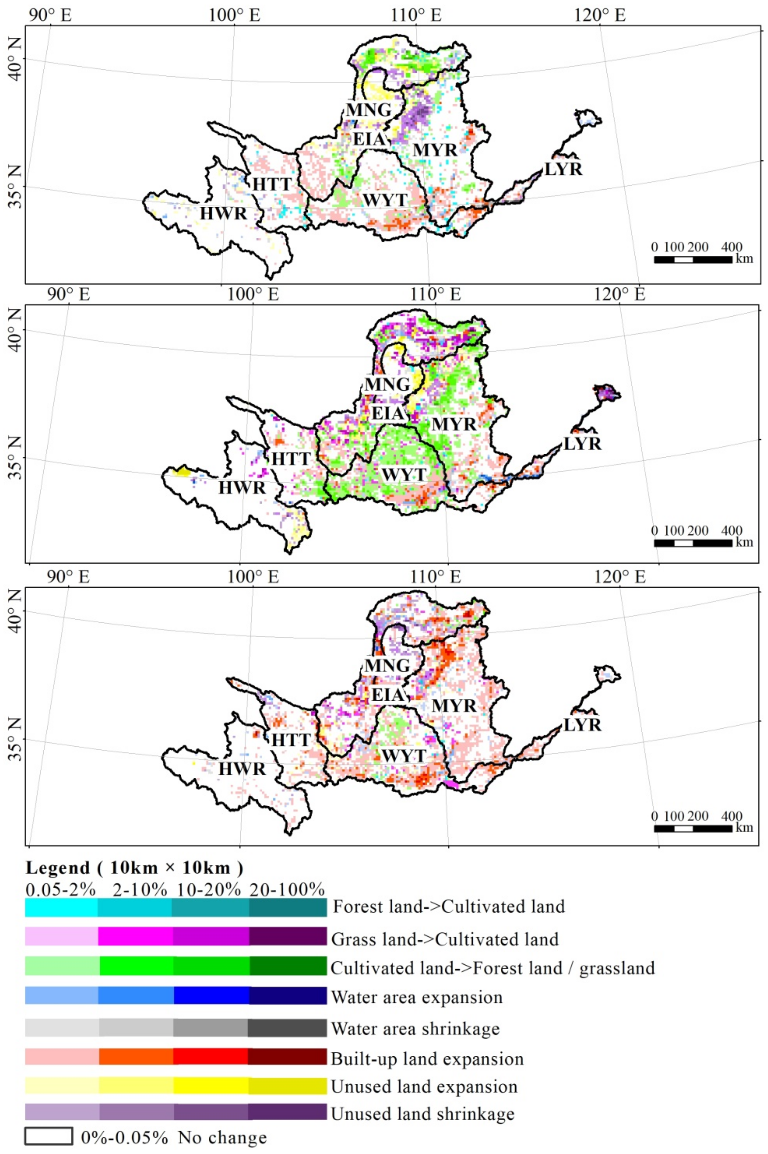
3.1. Spatial and Temporal Pattern of LUCC

From 1990 to 2018, the change in LUCC in the Yellow River Basin generally indicated that areas of cultivated land, grass land, and unused land decreased, and areas of forest land and built-up areas increased. In addition to the continuous expansion of built-up areas, there were significant differences in time and space in other LUCC types (Figure 3). From 1990 to 2000, the area of cultivated land increased by 1958.36 km2, grass land and forest land decreased by 2199.64 and 140.93 km2, respectively, and water and unused land areas slightly decreased. More than 50% of the newly reclaimed cultivated land occupied grass land, resulting in a sharp decrease in grass land. Forest land areas shrank, which was mainly converted into grass land. During the 2000–2010 period, the characteristics of LUCC mainly involved converting cultivated land to forest and grass land, with a total area of 4688.64 km2, resulting in an increase in forest land area at a rate of 28.06 km2/year. During 2010–2018, LUCC processes slowed down as a whole, and was mainly focused on urbanization, supplemented by conversion of cultivated land to forest land and grass land, with an ecological conversion area of 224.88 km2. The area of unused land significantly decreased, mainly turning into forest land and grass land, which indicates that the ecological construction projects achieved remarkable results.
According to the spatial distribution maps of LUCC in the Yellow River Basin in 1990–2000, 2000–2010, and 2010–2018 (Figure 4), the LUCC mode in 1990–2000 involved mainly reclamation of cultivated land and expansion of built-up areas, and it was mainly distributed in the middle reaches of the Yellow River system (MYR) and Weihe-Yiluo River system (WYT) area. The area of unused land in the Ordos inner flow area (EIA) substantially increased, and desertification showed increasing trends. The northern part of the upper reaches of the Yellow River system (MNG) was passively converted to grass land.
From 2000 to 2010, the main LUCC types in the Yellow River Basin were dominated by returning cultivated land to forest land and grass land and urban land expansion, which were mainly distributed in the middle reaches of the Yellow River system (MYR) and Weihe-Yiluo River system (WYT) areas. Largely due to the implementation of ecological projects, such as the conversion of cultivated land to forest land and grass land, about 50% of the cultivated land area in the middle reaches of the Yellow River (MYR), Weihe Yiluo River system (WYT), and the upper reaches of the Yellow River (MNG) were converted into grass land, and about one third was converted by forest land reconstruction projects in these three zones (Table 2). In addition, unused land in the upper reaches of the Yellow River main stream (MNG) and the Ordos inner flow area (EIA) was converted to grass land.
From 2010 to 2018, LUCC was mainly reflected in urban expansion and “green enhancement” of ecological programs, and the spatial scope and intensity of converting cultivated land to forest land and grass land were reduced. About 70% of the urban expansion area in the lower Yellow River system (LYR), Huangshui–Taohe River system (HYT), and Weihe–Yiluo River system (WYT) was mainly from cultivated land, whereas grass land was the main source of built-up areas in other regions. Urban expansion in the upper reaches of the Yellow River (MNG) and the middle reaches of the Yellow River (MYR) was mostly contributed to by grass land and cultivated land.

3.2. Dynamic Change of Spatial Patterns of Soil Wind Erosion

The SWEM of the Yellow River Basin during 1990–2018 was obtained based on the RWEQ (Figure 5). Our results showed that the SWEM has generally decreased (Slope1990–2018 = −0.38 t/(ha·a)) since the 1990s (Figure 6). To ensure that the time change of soil erosion intensity was consistent with LUCC analysis, we analyzed the changes in the soil erosion modulus during three periods of time, of which soil erosion intensity increased from 1990 to 2000, showed a downward trend from 2000 to 2010, and slowed down even more from 2010 to 2018. The SWEM went from 8.35 t/(ha·a) in 1990 to 5.66 t/(ha·a) in 2018, with significant annual variation. During this period, the intensity of soil wind erosion first increased and then continuously decreased. In terms of the SWEM, 90.63% of the study area showed a decrease, and some local areas showed a significant decrease in soil wind erosion.
From 1990 to 2018, the spatial distribution of soil wind erosion was basically unchanged (Figure 5), whereas soil wind erosion intensity varied among regions. The average annual SWEM of the upper reaches of the Yellow River (MNG) was 29.19 t/(ha·a). The area with moderate or higher wind erosion intensity accounted for a large proportion of the total area, followed by the Ordos inner flow area (EIA). The Weihe-Yiluo River system (WYT) and the headwater river system (HWR) of the Yellow River were dominated by mild and lower levels of erosion. From 1990 to 2018, the SWEM of each region decreased, showing different characteristics. Among them, the SWEM of the upper reaches of the Yellow River (MNG), Ordos inner flow area (EIA), middle reaches of the Yellow River (MYR), and lower reaches of the Yellow River (LYR) significantly decreased, and wind erosion intensity significantly decreased.
The regional evolution of the Ordos inner flow area and upper reaches of the Yellow River were similar to that of the whole area with respect to SWEM. In the middle reaches of the Yellow River system and Huangshui–Taohe River system area, the SWEM fluctuated greatly, but there was an obvious downward trend.

3.3. Impact of LUCC on Soil Wind Erosion

According to the overlay statistical analysis of the LUCC map across different periods and the corresponding spatial distribution map of SWEM to remove climate factor influences (Figure 2), the amount of soil wind erosion under different LUCC types was obtained.
From 1990 to 2018, LUCC reduced the net total amount of soil wind erosion by 15.5709 million tons, showing first an increasing trend and then a continuous decreasing trend. During 1990–2000, the amount of soil wind erosion increased by 6.517 million tons, but decreased by 8.144 million t in 2000–2010, and by 13.9436 million tons in 2010–2018. LUCC conversion affecting the increase and decrease of soil wind erosion were mainly between forest (shrub), grass land, cultivated land, town land, and desert. The total amount of soil wind erosion increased by 87.95% due to cultivated land reclamation (grass land and forest land to cultivated land), desertification (grass land and water area to desert), water area shrinkage (river to grass land, bare land, etc.), and grass land degradation (high coverage grass land to medium and low coverage grass land). Due to the ecological conversion (conversion of cultivated land to forest land and grass land), land management (conversion of bare land to forest land, grass land, and cultivated land, etc.), desertification control engineering, and ecological programs (desert or sandy land to forest land, grass land, and cultivated land), as well as improvements in grass land quality (low coverage grass land to high, medium coverage grass land and forest land) and other conversion types, the amount of soil wind erosion decreased by 91.68%. From 1990 to 2018, the regional differences in soil wind erosion caused by LUCC in the Yellow River Basin were obvious. Especially from 1990 to 2000, soil wind erosion in the upper reaches of the Yellow River and the Ordos inner flow area significantly increased (Figure 7). With the implementation of the policy for ecological conversion of cultivated land, soil wind erosion was effectively controlled and showed continuous decreasing trends (Figure 6). Since 2000, LUCC has reduced soil wind erosion by 39.7127 million tons, and contributed to 77.84% of the reduction in soil wind erosion in the upper reaches of the Yellow River, Ordos inner flow area, and middle reaches of the Yellow River. Soil wind erosion in other areas of the Yellow River Basin has also decreased to varying degrees.
Since 2000, China has implemented a series of ecological programs, such as the “Three North” Shelterbelt Plan (1978–2050) and a cultivated land conversion to forest land and grass land program (1999–2020). These programs aimed to reduce the adverse effects of soil erosion and achieve sustainable development. We found that soil wind erosion decreased at about 1.22 million tons/year from 2000 to 2018. The contribution rate of ecological programs was 59.13%, with a total wind erosion reduction of 17.8921 million tons. These results show that LUCC processes caused by ecological construction programs played an important role in the protection of the ecological environment (Figure 8).

4. Discussion

LUCC has multiple effects on the environment, including important effects on soil erosion [48,49,50]. Severe climate change and disturbance by human activities have led to the intensification of land degradation and increase in soil wind erosion intensity [31]. In the process of wind erosion, organic matter and nutrients are blown away by the wind along with soil particles, which leads to a decrease in soil fertility and net primary productivity of plants [30], which further affects regional ecosystem services (such as food supply and soil conservation) [30,31] and people’s livelihoods and welfare (such as traffic safety and human health) [51]. LUCC and structural changes caused by ecological engineering not only change landscape patterns, but also affect material circulation and energy flow [50], changing the spatial and temporal distribution of ecosystem services, such as carbon sequestration, biodiversity, and soil conservation. Further exploration and elucidation of the relationship between LUCC and ecological quality and functions, as well as the scientific diagnosis of the ecological effects and environmental function of LUCC, would be of great significance for improving regional environmental ecological quality and exploring high-quality development pathways [52,53].
In nearly 30 years, the macro structure of the whole natural ecosystem of the Yellow River Basin has significantly improved due to ecological environment restoration, protection, and management from the implementation of ecological engineering programs [19]. Soil wind erosion in the whole area has been reduced. However, wind and water erosion are both important in the Yellow River Basin, especially in the northern parts that have complex terrain. Cultivated land reclamation, grassland degradation, and desertification are still present. Under the dual influence of climate warming and human factors, some farmland and grassland ecosystems have suffered serious soil erosion. The development of industries and mining has caused local ecological environment damage, regional ecological quality decline, and decrease in the effectiveness of soil and water conservation. The existence of these problems will increase soil wind erosion and water erosion, and attention should be paid to these problems in future land use planning and management. We make the following recommendations: (1) Further strengthen the comprehensive improvements of “mountains, rivers, forests, fields, lakes and grass”, optimizing the structure layout of agricultural land, and improving soil and water conservation of agricultural land while increasing the quantity and quality of cultivated land and reducing the “fragmentation” of cultivated land. Carry out reclamation and ecological restoration of abandoned industrial and mining land and a small amount of inefficient idle construction land. (2) Continue to ensure the implementation of environmental protection projects, such as returning cultivated land to forest land or grass land, consolidating the achievements of ecological restoration and ecological construction, catering to the surrounding natural conditions and environment for “double evaluation” of territorial space planning, and ensuring the returning of cultivated land to promote forest land and grass land when appropriate. (3) Coordinate all elements of ecosystem types to implement integrated restoration of ecological space, especially in the process of desertification prevention and control, paying attention to the nesting of resource endowment and forest, shrub, and grass types, and ensuring the sustainability of “greening” ecological construction projects. (4) Stop excessive mining and digging in forest land and grass land, promote the restoration of grass land after mining, and reduce its impact on the ecological environment. (5) Strictly limit the agriculture of grass land, wetlands, and forest-irrigated land, and rationally utilize and optimize land resources.

5. Conclusions

In this paper, the relationship between LUCC evolution and soil wind erosion in the Yellow River basin was analyzed and discussed. The results showed that:
(1)
In the past 30 years, LUCC in the Yellow River Basin was mainly characterized by a rapid urbanization process and conversion between cultivated land, forest land, and grass land. Built-up areas increased by 8356.77 km², forest land area increased by 2746.61 km², cultivated land and grass land area decreased by 4333.19 and 6159.22 km², respectively, and water area and unused land area decreased by 64.53 and 546.44 km², respectively. There were obvious regional differences in LUCC processes, whereby the middle reaches of the Yellow River Basin (MYR), the Weihe-Yiluo river system (WYT), and upper reaches of the Yellow River main stream (MNG) underwent more intense LUCC than in the other regions. From 1990 to 2000, cultivated land reclamation and a decrease in forest land and grass land area were the main processes, whereas there were small decreases in water and unused land areas. From 2000 to 2010, LUCC was mainly in the form of conversion of cultivated land to forest land and grass land. In 2010–2018, the LUCC processes slowed down compared with 2000–2010, and was mainly reflected in urban expansion, supplemented by the conversion of cultivated land to forest land and grass land.
(2)
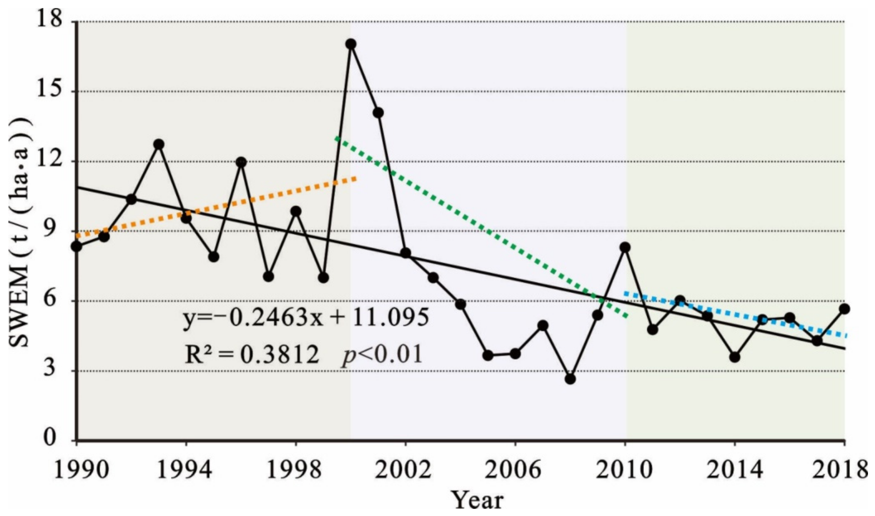
Based on the RWEQ model, the results of a long-term series estimation of soil wind erosion intensity in the Yellow River Basin showed that there were increases and decreases in soil erosion modulus and wind erosion volumes, but in general, the SWEM showed a downward trend. Compared with the total amount of wind erosion in 1990, the total amount of wind erosion decreased by more than half in 2018. During this period, the intensity of soil wind erosion first increased and then continuously decreased. The modulus of soil wind erosion decreased by 90.63% across the study area. The total amount of soil wind erosion significantly decreased, especially in the upper reaches of the Yellow River and the Ordos inner flow area.
(3)
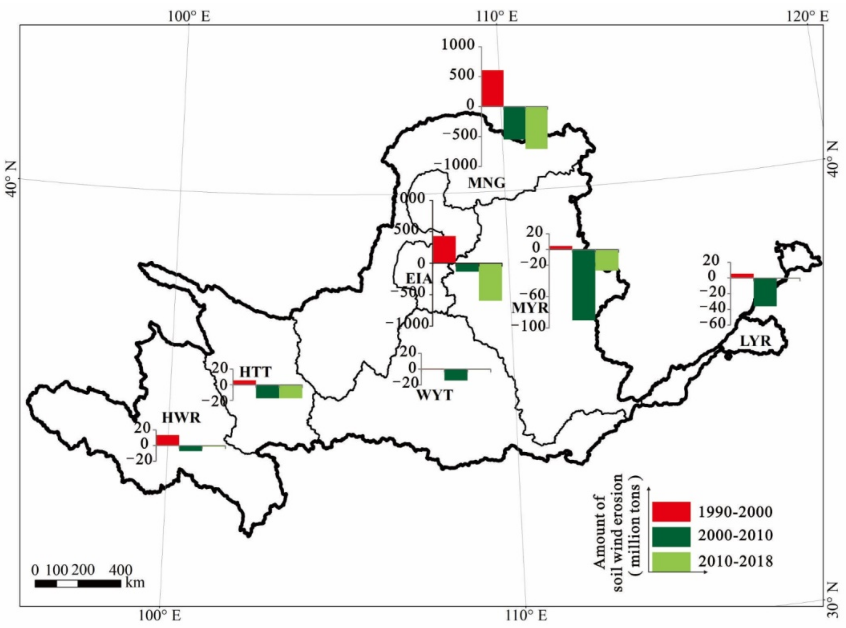
From 1990 to 2018, LUCC reduced the total amount of soil wind erosion by 15.57 million tons, which first increased and then continuously decreased. From 1990 to 2000, the conversion of grass land and forest land to cultivated land and the expansion of desert resulted in significant increases in wind erosion. During 2000–2018, wind erosion decreased at about 1.22 million tons/year. The contribution rate of ecological engineering programs to the reduction in regional wind erosion was 59.13%, and total wind erosion decreased by 17.89 million tons.

Author Contributions

W.C.: data curation and writing—original draft preparation. Y.N.: supervision, investigation, and reviewing and editing. W.C.: supervision, investigation, and data curation, editing and funding acquisition. Y.W.: reviewing and editing. Q.L.: conceptualization and validation. Y.L.: software and methodology. Q.L.: software and methodology. Y.N.: data curation. All authors have read and agreed to the published version of the manuscript.

Funding

This research was supported by the National Natural Science Foundation of China “Research on the Greening process and its mechanism of regional ecosystem services in Kubuqi Desert” (42061069), the Science and Technology Innovation Project of the Department of Natural Resources of Inner Mongolia Autonomous Region “Research on the sustainable utilization and development of natural resources with the integration of space and space in Inner Mongolia Autonomous Region”, the key technology and application of ecological quality diagnosis and integrated management of “Beautiful Inner Mongolia”(2019GG010), the Research Foundation of Education Bureau of Inner Mongolia, China (NJYT-19-B29), and the Inner Mongolia Autonomous Region Talent Development Fund Project in 2021.

Institutional Review Board Statement

Not applicable.

Informed Consent Statement

Not applicable to this paper.

Conflicts of Interest

The authors declare that the research was conducted in the absence of any commercial or financial relationships that could be construed as a potential conflict of interest.

References

  1. Foley, J.A.; Defries, R.; Asner, G.P.; Barford, C.; Bonan, G.; Carpenter, S.; Chapin, F.S., III; Coe, M.; Daily, G.; Gibbs, H.; et al. Global consequences of land use. Science 2005, 309, 570–574. [Google Scholar] [CrossRef] [Green Version]
  2. Popp, A.; Humpenöder, F.; Weindl, I.; Bodirsky, B.; Bonsch, M.; Lotze-Campen, H.; Müller, C.; Biewald, A.; Rolinski, S.; Stevanovic, M.; et al. Land-use protection for climate change mitigation. Nat. Clim. Chang. 2014, 4, 1095–1098. [Google Scholar] [CrossRef]
  3. Schimel, D. Drylands in the earth system. Science 2010, 327, 418–419. [Google Scholar] [CrossRef] [PubMed]
  4. Pravalie, R. Drylands extent and environmental issues. A global approach. Earth-Sci. Rev. 2016, 161, 259–278. [Google Scholar] [CrossRef]
  5. Sachs, J.; Reid, W. Investments toward sustainable development. Science 2006, 312, 1002. [Google Scholar] [CrossRef] [PubMed] [Green Version]
  6. Gao, L.; Bryan, B.A. Finding pathways to national-scale land-sector sustainability. Nature 2017, 544, 217–222. [Google Scholar] [CrossRef]
  7. Pretty, J.; Benton, T.G.; Bharucha, Z.P.; Dicks, L.; Flora, C.; Godfray, C.; Goulson, D.; Hartley, S.; Lampkin, N.; Morris, C.; et al. Global assessment of agricultural system redesign for sustainable intensification. Nat. Sustain. 2018, 1, 441–446. [Google Scholar] [CrossRef]
  8. Nagendra, H.; Bai, X.M.; Brondizio, E.S.; Lwasa, S. The urban south and the predicament of global sustainability. Nat. Sustain. 2018, 1, 341–349. [Google Scholar] [CrossRef]
  9. Black, D. The International Council for Science. Chem. Int. 2014, 36, 2–4. [Google Scholar] [CrossRef]
  10. Kuang, W.H. Issues regarding spatial pattern change of national land space and its overall implementation on beautiful vision in new era. Resour. Sci. 2019, 41, 23–32. [Google Scholar] [CrossRef]
  11. Zhang, H.; Fan, J.; Cao, W.; Harris, W.; Li, Y.; Chi, W.; Wang, S. Response of wind erosion dynamics to climate change and human activity in Inner Mongolia, China during 1990 to 2015. Sci. Total Environ. 2018, 639, 1038–1050. [Google Scholar] [CrossRef]
  12. Lal, R. Soil erosion and the global carbon budget. Environ. Int. 2003, 29, 437–450. [Google Scholar] [CrossRef]
  13. Ye, D.; Chou, J.; Liu, J.; Zhang, Z.; Wang, Y.; Zhou, Z.; Ju, H.; Huang, Q. The causes and control measures of sand and dust weather in North China. Acta Geogr. Sin. 2000, 55, 513–521. [Google Scholar] [CrossRef]
  14. Shi, P.; Yan, P.; Yuan, Y. The driving force analysis of the blown-sand activity in Northern China. Quat. Res. 2001, 21, 41–47. [Google Scholar] [CrossRef]
  15. Zhao, Y.; Wu, J.; He, C.; Ding, G. Linking wind erosion to ecosystem services in drylands: A landscape ecological approach. Landsc. Ecol. 2017, 32, 2399–2417. [Google Scholar] [CrossRef]
  16. Fu, B.; Qiu, Y.; Wang, J.; Chen, L. Impact of land use change on soil and water loss in small watershed of loess hilly region. Acta Geogr. Sin. 2002, 57, 717–722. [Google Scholar] [CrossRef]
  17. Fu, B. Ecosystem Services and Ecological Security; Higher Education Press: Beijing, China, 2013; pp. 15–16. [Google Scholar]
  18. Liu, Y.; Yang, Z.; Lin, P.; Zheng, Z.; Xie, S. Comparison and evaluation of multiple land surface products for the water budget in the Yellow River Basin. J. Hydrol. 2020, 584, 124534. [Google Scholar] [CrossRef]
  19. Zheng, J.; Wen, Y.; Fang, X. Some characteristics of climate and land cover changes in the middle and lower reaches of the Yellow River in the past 2000. Resour. Sci. 2020, 42, 3–19. [Google Scholar] [CrossRef]
  20. He, Z.; He, J. Remote sensing monitoring of the spatiotemporal evolution of vegetation coverage in the Yellow River Basin in the past 32 years. J. Agric. Mach. 2017, 48, 179–185. [Google Scholar] [CrossRef]
  21. Wang, K.; Huang, J.; Zhao, Y. Experiences and practices of key small watershed management for ecological engineering in the Yellow River Basin. Soil Water Conserv. China 2002, 10, 16–17. [Google Scholar]
  22. Fu, B.; Zhao, W.; Chen, L.; Lv, Y.; Wang, D. Multi-scale soil erosion evaluation index. Chin. Sci. Bull. 2006, 16, 1936–1943. [Google Scholar] [CrossRef]
  23. Liu, J.; Kuang, W.; Zhang, Z. Spatiotemporal characteristics, patterns and causes of land use changes in China since the late 1980s. Acta Geogr. Sin. 2014, 69, 3–14. [Google Scholar] [CrossRef]
  24. Feng, X.; Fu, B.; Piao, S.; Wang, S.; Ciais, P.; Zeng, Z.; Lu, Y.; Zeng, Y.; Li, Y.; Jiang, X.; et al. Revegetation in China’s Loess Plateau is approaching sustainable water resource limits. Nat. Clim. Chang. 2016, 6, 1019–1022. [Google Scholar] [CrossRef]
  25. Huang, B. Preliminary draft of comprehensive natural regionalization in China. Acta Geogr. Sin. 1958, 4, 348–365. [Google Scholar] [CrossRef]
  26. Sun, X. 7Be and 137Cs Tracer Study of Soil Erosion Rate in the Wind-water Erosion Crisscross Region on the Loess Plateau; University of Chinese Academy of Sciences: Beijing, China, 2012. [Google Scholar]
  27. Zhang, C.; Zhou, X.; Dong, G.; Liu, Y. Experimental study on the effect of vegetation on soil wind erosion by wind tunnel. J. Soil Water Conserv. 2003, 3, 31–33. [Google Scholar]
  28. Chi, W.; Bai, W.; Liu, Z.; Dang, X.; Kuang, W. Research on Soil Wind Erosion in Inner Mongolia Plateau Based on RWEQ Model. J. Ecol. Environ. 2018, 6, 1024–1033. [Google Scholar] [CrossRef]
  29. Du, H.; Xue, X.; Wang, T.; Deng, X. Estimation of wind erosion modulus and sand flow into the Ningmeng section of the Yellow River from 1986 to 2013. J. Agric. Eng. 2015, 31, 142–151. [Google Scholar] [CrossRef]
  30. Qu, Y.; Zhao, Y.; Ding, G.; Chi, W.; Gao, G. Spatiotemporal patterns of the forage-livestock balance in the Xilin Gol steppe, China: Implications for sustainably utilizing grassland-ecosystem services. J. Arid Land. 2021, 13, 135–151. [Google Scholar] [CrossRef]
  31. Chi, W.; Zhao, Y.; Kuang, W.; He, H. Impacts of anthropogenic land use/cover changes on soil wind erosion in China. Sci. Total Environ. 2019, 668, 204–215. [Google Scholar] [CrossRef]
  32. Zhao, Y.; Chi, W.; Kuang, W.; Bao, Y.; Ding, G. Ecological and environmental consequences of ecological projects in the Beijing–Tianjin sand source region. Ecol. Indic. 2020, 112, 106–111. [Google Scholar] [CrossRef]
  33. Sun, H.; Shi, P.; Yan, B.; Liu, C. Study on Environmental Impact Assessment of Land Use Scale and Structural Adjustment in Ecologically Vulnerable Areas on the Upper Yellow River—Taking Lanzhou as an Example. Bull. Soil Water Conserv. 2013, 33, 245–249. [Google Scholar]
  34. Fu, B.; Wang, S.; Liu, Y.; Liu, J.; Liang, W.; Miao, C. Hydrogeomorphic ecosystem responses to natural and anthropogenic changes in the loess plateau of China. Annu. Rev. Earth Planet. Sci. 2017, 45, 223–243. [Google Scholar] [CrossRef]
  35. Deng, X.; Zhang, J.; Yang, M.; Zhang, F.; Liu, Z. Soil wind erosion characteristics of slope farmland in water-wind erosion crisscross region on the Loess Plateau. Res. Soil Water Conserv. 2019, 26, 1–6. [Google Scholar]
  36. Liu, Z.; Yang, M.; Zhang, J. Spatial distribution of soil wind erosion rate on slope farmland in water-wind erosion crisscross region on the Loess Plateau. Chin. Sci. Bull. 2016, 61, 511–517. [Google Scholar] [CrossRef]
  37. Li, Y.; Yang, G.; Feng, Y.; Kang, J.; Wu, H. The effect of corn ridge mulching and water collecting in the wind eroded area of the Loess Plateau. J. Agric. Eng. 2009, 25, 59–65. [Google Scholar]
  38. Zhang, S.; Jia, Y.; Lu, F.; Zhang, Y.; Zhang, S.; Peng, Z. Effects of upward seepage on the resuspension of consolidated silty sediments in the yellow river delta. J. Coast. Res. 2019, 36, 372. [Google Scholar] [CrossRef]
  39. Bryan, B.; Gao, L.; Ye, Y.Q.; Sun, X.; Connor, J.; Crossman, N.; Stafford, S.; Wu, J.; He, C.; Yu, D.; et al. China’ s response to a national land-system sustainability emergency. Nature 2018, 559, 193–204. [Google Scholar] [CrossRef]
  40. Niu, Z.; Yang, G.; Li, Y. Changes in the Channel of the Lower Yellow River during the Historical Period; Surveying and Mapping Press: Beijing, China, 1994; pp. 10–12. [Google Scholar]
  41. Huang, S.; Huang, Q.; Chang, J.; Leng, G.; Xing, L. Drought structure based on a nonparametric multivariate standardized drought index across the Yellow River basin, China. J. Hydrol. 2015, 530, 127–136. [Google Scholar] [CrossRef]
  42. Yao, W.; Wu, D. Analysis of basic characteristics and changing trends of temperature and precipitation in the Yellow River Basin in the past 50 years. China Rural Water Conserv. Hydropower 2014, 8, 104–109. [Google Scholar]
  43. Zhang, Z.; Wang, X.; Zhao, X.; Liu, B.; Yi, L.; Zuo, L.; Wen, Q.; Liu, F.; Xu, J.; Hu, S. A 2010 update of National Land Use/Cover Database of China at 1:100000 scale using medium spatial resolution satellite images. Remote Sens. Environ. 2014, 149, 142–154. [Google Scholar] [CrossRef]
  44. Liu, J.; Ning, J.; Kuang, W.; Xu, X.; Zhang, S.; Yan, C.; Li, R.; Wu, S.; Hu, Y.; Du, G.; et al. Spatio-temporal patterns and characteristics of land-use change in China during 2010–2015. Acta Geogr. Sin. 2018, 5, 789–802. [Google Scholar] [CrossRef]
  45. Fryrear, D.; Krammes, C.; Williamson, D.; Zobeck, T. Computing the wind erodible fraction of soils. J. Soil Water Conserv. 1994, 49, 183. [Google Scholar]
  46. Liu, G.; Wu, B.; Fan, W.; Li, X.; Fan, N. Extraction of Vegetation Coverage in Desertification Area Based on Pixel Dichotomy Model—Taking Maowusu Sandy Land as an Example. Res. Soil Water Conserv. 2007, 2, 268–271. [Google Scholar]
  47. Oro, L.; Colazo, J.; Buschiazzo, D. RWEQ -Wind erosion predictions for variable soil roughness conditions. Aeolian Res. 2016, 20, 139–146. [Google Scholar] [CrossRef]
  48. Skidmore, E.; Tatarko, J. Stochastic wind simulation for erosion modeling. Trans. ASAE 1990, 6, 1893–1899. [Google Scholar] [CrossRef]
  49. Fu, B.; Chen, L. Agricultural landscape spatial pattern analysis in the semi-arid hill area of the Loess Plateau, China. J. Arid Environ. 2000, 44, 291–303. [Google Scholar] [CrossRef] [Green Version]
  50. Borrelli, P.; Robinson, D.A.; Fleischer, L.R.; Lugato, E.; Ballabio, C.; Alewell, C.; Meusburger, K.; Modugno, S.; Schütt, B.; Ferro, V.; et al. An assessment of the global impact of 21st century land use change on soil erosion. Nat. Commun. 2017, 8, 2013. [Google Scholar] [CrossRef] [Green Version]
  51. Jiang, Y.; Gao, Y.; Dong, Z.; Liu, B.; Zhao, L. Simulations of wind erosion along the Qinghai-Tibet Railway in north-central Tibet. Aeolian Res. 2018, 32, 192–201. [Google Scholar] [CrossRef]
  52. Gao, F.; Zhao, X.; Song, X.; Wang, B.; Wang, P.; Niu, Y.; Wang, W.; Huang, C. Connotation and Evaluation Index System of Beautiful China for SDGs. Adv. Earth Sci. 2019, 34, 295–305. [Google Scholar] [CrossRef]
  53. Li, D.; Xu, E.; Zhang, H. Influence of ecological land change on wind erosion prevention service in arid area of northwest China from 1990 to 2015. Ecol. Indic. 2020, 117, 106686. [Google Scholar] [CrossRef]
Figure 1. Land use/cover change type maps of different regions in the Yellow River Basin.
Sustainability 14 12930 g001
Figure 2. Simulation method and verification of soil wind erosion modulus (SWEM) based on the revised wind erosion equation. (a) Revised wind erosion model(RWEQ); (b) Distribution of verification points for accuracy of soil wind erosion modulus; (c) Field sampling and parameter localization process; (d) Accuracy verification and chievement correction of soil wind erosion modulus.
Sustainability 14 12930 g002
Figure 3. Statistics on LUCC area change in the Yellow River Basin from 1990 to 2018.
Sustainability 14 12930 g003
Figure 4. Spatial distribution of main LUCC type conversions in the Yellow River Basin from 1990 to 2018.
Sustainability 14 12930 g004
Figure 5. Spatial distribution patterns and regional evolution of trends of soil wind erosion intensity in the Yellow River Basin from 1990 to 2018.
Sustainability 14 12930 g005
Figure 6. Statistics of SWEM changes in the Yellow River Basin from 1990 to 2018.
Sustainability 14 12930 g006
Figure 7. Effects of land use/cover change (LUCC) on soil wind erosion in different regions of the Yellow River Basin.
Sustainability 14 12930 g007
Figure 8. Effect of LUCC caused by ecological programs on soil wind erosion in the Yellow River Basin.
Sustainability 14 12930 g008
Table 1. The data and input parameters of the RWEQ model.
Data TypeSpatial Resolution/ScaleTemporal ResolutionFormat
Land use/cover data1:101990–2018shpfile
Meteorological dataObservation sitesDailyTxt
Normalized difference vegetation index (NDVI)
data
1 kmHalf-monthRaster
Soil date data1:10N/Ashpfile
Snow covered data1 kmHalf-monthRaster
Vegetation coverage sample dataSample points2010, 2015, 2018shpfile
Soil organic matter content dataSample points2010, 2015, 2018shpfile
Digital elevation model (DEM) data90 mN/ARaster
Base geographic data1:25N/Ashpfile
Landform type data1:25N/Ashpfile
Note: N/A means not applicable.
Table 2. Transfer matrix of land use/cover change in different regions of the Yellow River Basin from 1990 to 2018 (×10² km²).
YearRegionGrass Land ->
Cultivated Land
Cultivated Land ->
Forest/Grass
land
Other ->
Built Up
Forest Land->
Cultivated Land
Water Area ->
Other
Other -> Water AreaUnused Land ShrinkageUnused Land
Expansion
1990–2000EIA1.570.090.110.130.010.354.188.14
MNG22.6312.261.910.462.082.378.5613.25
LYR0.410.081.690.000.724.031.280.23
HWR0.600.010.090.000.560.340.320.70
MYR4.020.013.600.521.423.7415.414.37
HTT3.060.070.760.180.300.150.050.04
WYT6.151.365.160.330.520.710.360.01
Total38.4516.0113.331.635.6111.6930.1626.74
2000–2010EIA1.103.660.390.020.160.372.536.90
MNG11.2911.136.260.493.894.546.999.53
LYR3.620.065.450.142.651.236.150.62
HWR0.740.090.160.000.500.001.378.47
MYR1.4717.216.290.273.652.641.835.49
HTT0.712.621.160.070.420.110.200.21
WYT0.9612.126.590.141.000.540.380.12
Total19.8946.8926.301.1312.299.4219.4531.34
2010–2018EIA0.650.102.130.040.110.136.100.11
MNG2.520.8914.750.172.641.428.932.30
LYR0.000.011.710.000.160.030.000.02
HWR0.000.001.220.000.170.150.160.13
MYR0.800.1513.370.340.770.572.620.96
HTT0.170.102.620.030.520.050.420.22
WYT0.380.998.400.100.690.160.050.60
Total4.522.2544.200.685.082.5118.294.35
Publisher’s Note: MDPI stays neutral with regard to jurisdictional claims in published maps and institutional affiliations.

