Article

Grounding the SHIELD Model for Tropical Coastal Environments

1
Earth Sciences Department, EAFIT University, Medellín 050022, Colombia
2
Coastal Systems Research Group, Playas Corporation Ltd., Santa Marta 470004, Colombia
3
School of Law, University Sergio Arboleda, Santa Marta 470004, Colombia
4
Marine and Coastal Geosciences Program, Marine and Coastal Research Institute “José Benito Vives de Andréis” (INVEMAR), Salguero Beach, Rodadero, Santa Marta 470006, Colombia
5
Department of Marine and Environmental Science, Hampton University, Hampton, VA 23669, USA
6
Civil and Environmental Department, GeMarc Group, Universidad de la Costa, Barranquilla 080001, Colombia
*
Author to whom correspondence should be addressed.
Sustainability 2022, 14(19), 12317; https://doi.org/10.3390/su141912317
Submission received: 29 August 2022 / Revised: 16 September 2022 / Accepted: 21 September 2022 / Published: 28 September 2022

Abstract

:
Customizing environmental assessments to the particularities of the type of environment is crucial for implementing the precautionary principle. This paper uses the SHIELD model (Susceptibility to Human Interventions for Environmental Licensing Determination) in the context of geomorphology for the effective management of coastal environments. This paper describes the customization of the SHIELD model for tropical coastal environments as a way of validating a specific kind of environment. The assessment translates expert knowledge into technical criteria for the environmental control of human interventions through fuzzy logic computations. This assessment identified 21 geomorphological processes across six categories. Moreover, computation of the parameters resulted in a database of susceptibility measures for 4524 interactions. These quantitative results could guide future environmental impact studies of coastal environments, considering licensing instrument requirements. The SHIELD model approach, illustrated here on tropical coastal environments, offers a technical alternative for improving the environmental control of anthropogenic impacts from a geomorphological perspective.

1. Introduction

There is limited literature linking the contribution of geomorphology to the assessment and management of environmental impacts. The Susceptibility to Human Interventions for Environmental Licensing Determination (SHIELD) model [1] relies on a novel geomorphological interpretation of Environmental Impact Assessment (EIA) to achieve a balance between precaution and efficiency.
However, the validity of this conceptual approach requires illustration in a specific environment to elaborate on different practical aspects that might encourage further feedback from scholars and stakeholders in the earth and environmental sciences field. This study defines SHIELD model parameters for tropical coastal environments to illustrate its operation as a management instrument and explore further applications in territorial planning. This incorporates an ecosystem-based approach.
The SHIELD model was conceived to provide technical grounds for environmental licensing procedures, beginning with screening and scoping, providing a basis for the effective identification, assessment, and control of environmental impacts. The screening stage discriminates anthropic interventions requiring an impact assessment and the complexity of its licensing procedure, whereas scoping sets the physical, temporal, and conceptual reach of the environmental assessment for the screened-in interventions [2]. The SHIELD model describes a technical approach, where the estimated susceptibility for a distinctive kind of environment corresponds to the screening strategy that combines locational and human-intervention conditions. Similarly, the scoping strategy of SHIELD corresponds to a technocratic model for customizing the terms of reference of the environmental assessment to the estimated disturbance caused by the natural processes in an intervention/landform interaction. As the susceptibility concept in SHIELD relies on understanding landscape evolution through geomorphological processes, this model discriminates between different kinds of environments to reconceptualize management problems from an ecosystem-based perspective [1]. The illustration of the geomorphological approach of the SHIELD model in coastal environments should identify the varying characteristics of littoral landforms and their driving processes.
In the case of coastal environments, the study of earth–surface processes poses an advantage in reconceptualizing management problems from a geomorphological perspective. For one thing, coastal geomorphology incorporates the characteristics and processes that shape the land–sea interface [3]. This appears in the littoral classification found in most textbooks on the topic [4,5,6]. Generally, ‘coastal processes’ are considered bounded by the extremes of littoral boundaries, thus extending from the depths where waves and currents move marine sediments to the terrestrial margin that shows little influence from the ocean system [5,7]. As such, many references focus on the morpho-dynamic processes involving marine-driving forces [3,8,9] or climatic approaches [3,6]. Attention to coastal erosion and flooding is driving an increased interest in using a geomorphological approach for more effective management [10,11,12]. Given the comprehensive reach of the coastal zone, a geomorphological approach for addressing management problems must include the full range of effects observed across the full extent of the system [13,14]. This work emphasizes the organic systems influencing coastal morphology, instead of using the traditional reductionist understanding of coastal processes.
The literature provides distinct metrics for identifying these natural processes. The geology of a location accounts for its endogenic and exogenic processes and their interactions [3]. Geology is used as the basis for the structure and lithology of coastlines [3,8,15]. The geochemistry of a location accounts for the transformation and modeling of the Earth’s crust. The climate accounts for both longer-term influences on the crust, as well as salutatory exogenic processes that occur during brief periods [3,8,15]. Hydrodynamic, eolic, and biogenic processes explain much of the morphology of the water–sea interface [6,16]. In addition to these natural agents, anthropogenic activities help shape coastal environments. Coastal environmental zoning would benefit from a geomorphological approach that accounts for these natural and anthropogenic factors.
The geomorphological approach of the SHIELD model fills a void in the application of practical knowledge to management of environmental impacts. The SHIELD model identifies three parameters (landforms, human interventions, and geomorphological processes) used to manage the environment. It considers these parameters in the context of their interconnections via process affectation and process importance [1]. This paper evaluates the geomorphological approach of susceptibility in the SHIELD model, applied specifically on tropical coastal environments. Section 2 outlines the methodology of applying the SHIELD model to the effects of human interventions. Section 3 presents the results of the three sets of parameters for tropical coastal zones, their interaction through two variable matrices, and final consolidation into a susceptibility database. Section 4 expands on the foundations of the SHIELD approach, illustrating the uncertainties overcome with fuzzy algebra, and the work ahead for improving the operation of this susceptibility model. Therefore, this paper implements the SHIELD model on tropical coastal environments to illustrate its operation as a management instrument for environmental impacts. The novelty of this work relies on reconceptualizing the management of environmental impacts from an ecosystem-based perspective, by defining interactions among distinctive landforms, human interventions, and geomorphological processes using a methodological approach.

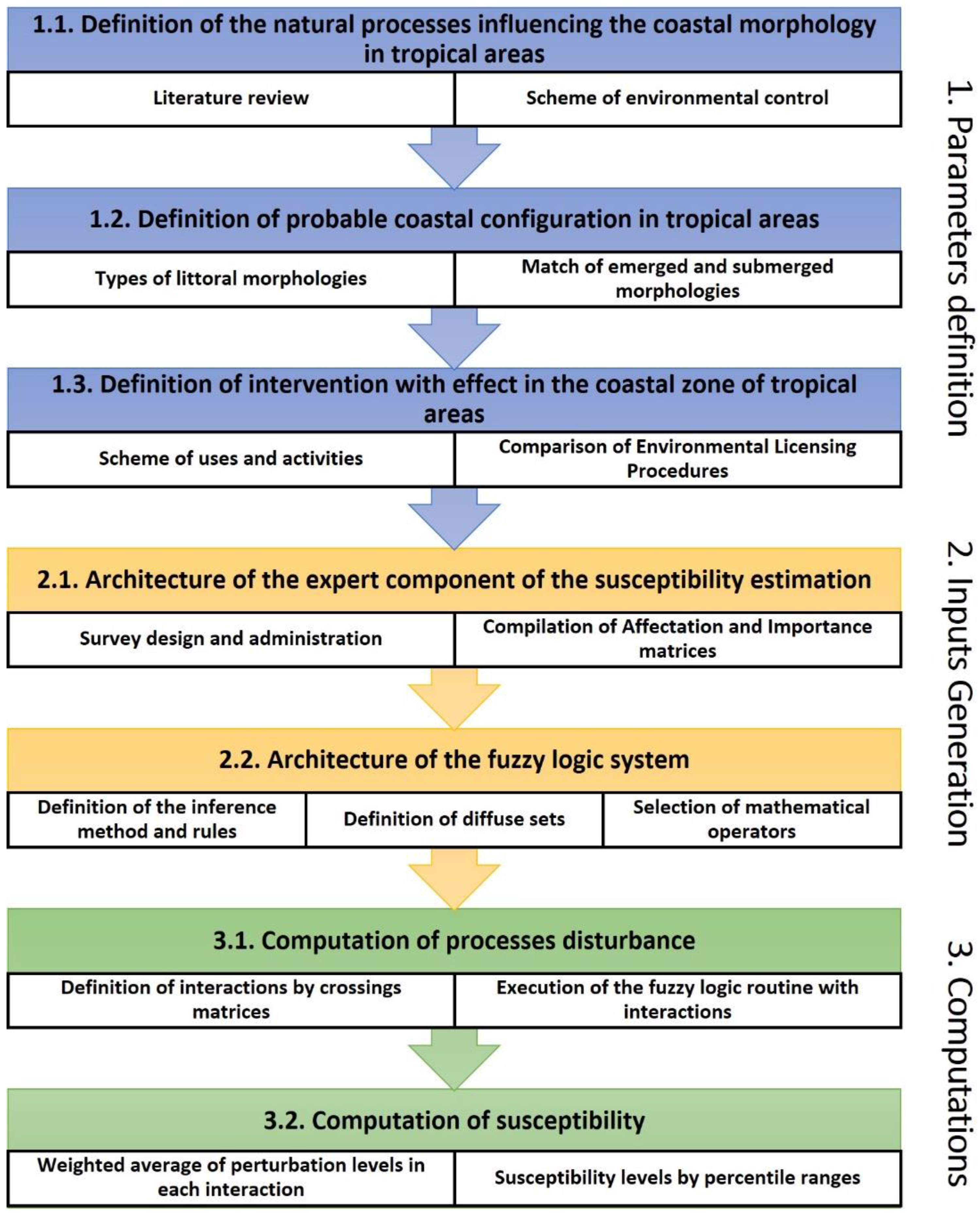
2. Materials and Methods

The SHIELD model establishes two variables of process disturbance that need to be estimated and combined into a cross matrix: importance and affectation. Such approximations for a distinctive kind of environment comprehends the three gross steps followed in this work, namely definition of parameters, generation of inputs, and computation of variables (Figure 1). The first stage (definition of parameters) requires the conceptualization of natural processes influencing the coastal morphology, derived from the work of several authors [3,5,6,8,15,16], and is further adapted for coastal zone regulations [17]. To define the probable littoral configurations in tropical coasts, a revision of the main coastal classifications was developed [18,19], with the special distinction of emerged and submerged typologies. The distribution and organization of the selected emerged morphologies was inspired by the coastal typologies of the Cuban legal system and proposals for its improvement [13,20,21]. The final littoral configurations were the result of matching selected emerged composition of morphologies with selected submerged ones. Lastly, the list of human interventions with relevance to tropical coasts was adapted from a generic scheme of uses and activities in the coastal zone, along with a comparison of activities under environmental licensing within countries of different development status [14,22,23].
The second stage is input generation. This includes an expert component that identifies data for the variables of process importance on a given littoral configuration and process affectation due to human intervention. These values were populated from a survey from a group of experts on coastal processes involved in sequential conferences with the Marine and Coastal Research Institute “José Benito Vives de Andréis” (INVEMAR, that serves as the official consultant in marine-coastal matters to the national environmental licensing authority in Colombia). We used Question Pro® with a numeric slider to create two different questionnaires. Questionnaire Type 1 was for rating process importance in littoral configurations and Type 2 was for process affectation due to human interventions (see [24]). Raw data were downloaded to a Microsoft EXCEL® spreadsheet for computation of the mean value of registered answers. This was the basis for the fuzzy logic computations in MATLAB®. The architecture of the fuzzy logic system translated expert knowledge into a synthetic measure of disturbance as a unique interaction (intervention vs. configuration). The parameters of the fuzzy system algorithm can be seen in Appendix A.
The third stage defined the number of interactions to be calculated via a matrix that crossed each human intervention with each littoral configuration. By this point, each interaction would have two data streams of the same extension, corresponding to the affectation and importance of each natural process influencing the coastal morphology. The fuzzy system based on the Mardani inference method [25] was programmed in MATLAB to run a routine that computed a value of disturbance for each geomorphological process at each intervention/configuration interaction. The final computation applying the SHIELD model to the parameters of coastal environments involves the integration of the n values of process disturbances at each interaction into one single susceptibility value. A weighted average was used, based on a Gaussian normal distribution depicted in the ranges and formula of Table 1. The outcome of performing this computation of the n values of process disturbance at the i, x, and j number of interactions are derived into a database. This corresponds to the estimated susceptibility of the j littoral configurations to the effect of i types of human interventions, defined for tropical coastal environments.

3. Results

3.1. Parameters of the SHIELD Model for Tropical Coastal Environments

Three parameters were established as the core of the SHIELD model for tropical coastal environments: 1. Geomorphological processes; 2. Morphological/littoral configurations; and 3. Human interventions (Figure 2; see Appendix B for further details). A list of 21 natural processes influencing the coastal morphology of tropical environments and their distribution into six categories were identified by experts and literature review. The geologic category included eight processes that addressed the relocation of materials and related factors linked to the geomorphology of littoral sediments [3,6]. The geochemical category addressed two processes driven by the physicochemical properties of the coastal environment [16]. The climatic category included four processes understood in the context of general and localized meteorological patterns [5,15]. The hydrodynamic category included information on waves, tides, and currents [8,9]. The eolic category considered two processes associated with movements of air and their influence on the landscape. The biogenic category included two processes driven by the biota that alter the structure of the shore [5,16].
A list of 87 littoral configurations was consolidated from eleven emerged and eight submerged subunits. The construction of littoral subunits considered geomorphological features. Due to the environmental complexity, a singular feature, such as a beach, comprises seven littoral emerged subunits, including cushioning systems (e.g., lagoons, dunes, and floodplains). Sparse detail on marine morphological classifications [19] meant that the submerged subunits were estimated from probable scenarios in tropical coasts. Overall, the linkage between relief and biogenic coverages in the resulting littoral configurations describe substrate distribution patterns that emulate the cellular and vector properties of the landscape [26].
A total of 52 interventions distributed across nine categories were delineated as works or activities that disturbed the natural coastal processes. Five interventions altered basin drainage to littoral areas. Another six were catalogued as edifications, distinguishing agglomerations from singular typologies. The category, marine navigation facilities, had the highest number of interventions (n = 11). Industrial and energy installations (n = 7) included conventional and emerging technologies. Linear infrastructure (n = 7) refers to roads, rail lines, and pipelines. Remaining interventions (n = 16) included extensive land- use, such as livestock, extractive activities, and basic sanitation facilities that included both drinking and wastewater systems.

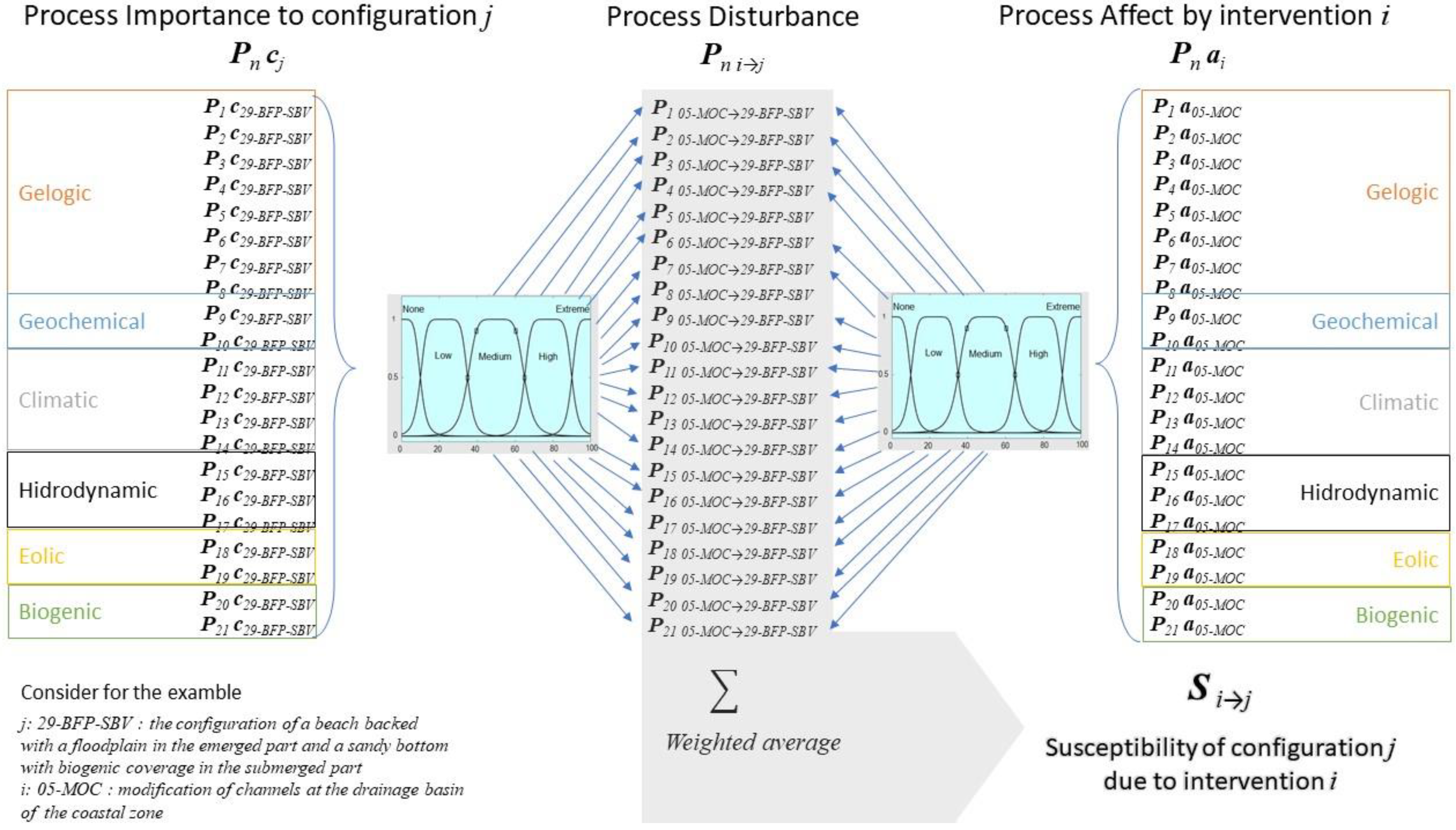
3.2. Susceptibility Matrix of the SHIELD Model for Tropical Coastal Environments

The boxplot diagram for the various processes illustrates the differences in values of importance associated with each configuration (see Appendix C). The measures organized in crosstabulation of process importance for the 87 conformations yielded a medium variability, extending from 10.25 (low influence) to 100 (determinant), with a mean value of 61.07 (SD 18.03). Notably, the sandy substratum with biological coverage in the submerged part (codes 23-NBX-SBV, 24-BBD-SBV, 25-BVD-SBV, and 26-BCT-SBV) yielded the highest measures of process importance (see the codes in Appendix B). Cliffs or terraces in the emerged part of the littoral configuration (codes 42-CTR- HBR, 43-CTN-HBR, 86-CTR-ROB, and 87-CTN-ROB) produced the lowest measures of process importance. The lowest mean value of importance (33.9) in Physical weathering by structural controls (P4) produced the lowest values of importance (mean 33.9, SD 23.5). In contrast, littoral erosion (P15) and wave generation by wind (P18) presented the highest mean values (81.9, SD 5 and 82.5, SD 7.5), respectively. Vertical movements associated with diapirism (P2) produced a fairly high mean value (74, SD 3.8) This illustrates the importance of differentiating the various types of processes and geomorphological configurations when projecting the impact of an action.
The affectation matrix of the 21 processes due to the 52 interventions presented a mean value of process affectation of 12.11 (SD 26.93, Appendix C). High density settlements (9-AHA) yielded the highest values of stress. The opposite was true for fishing (21-FFF). The highest mean values of affectation by process (~35) were presented in the hydrodynamic category (P15, P16, and P17), which also produced the highest variability of data dispersion (SD 32). Meanwhile, more than 90% of the interventions reported ratings of none for affectation in the first three processes of the climatic category (P11, P12, and P13) with a mean value of 1.25. A similar pattern was observed with the geological process associated with neotectonics (P3), which was consistent with the same reach of global and wide-regional scales of the climatic processes. Conversely, one intervention of the linear infrastructure category (40-RDS) in biogenic processes (P20 and P21) and 12 other interventions in three categories of hydrodynamic processes reported ratings of complete affectation.
For human interventions, the majority of navigation and marine facilities appeared to strongly affect hydrodynamic processes (14-EMP, 17-EDM, 19-PUG, 20-SPS, 22-INA, and 24-MMN). Extractive activities (37-DMI and 39-MDS) and works of coastline protection (48 ROP, 49CYP, 50-MU, and 51-BNS) also showed strong effects. Furthermore, a group of three interventions reported ratings of none and low affectation on the 21 processes: solar power plants (28-SEP), electric lines and installations (45-ELF), and manufacturing (31-MAN). Three interventions reported the highest number of processes (n = 13), with ratings above medium affectation: marine dredging (39-MDS), inlet navigation channels (14-EMP), and the intervention of exploitation and solid waste disposal (53-SWD). In sum, these results suggest that only certain processes appear sensitive to human interventions, such as the ones in the hydrodynamic category.

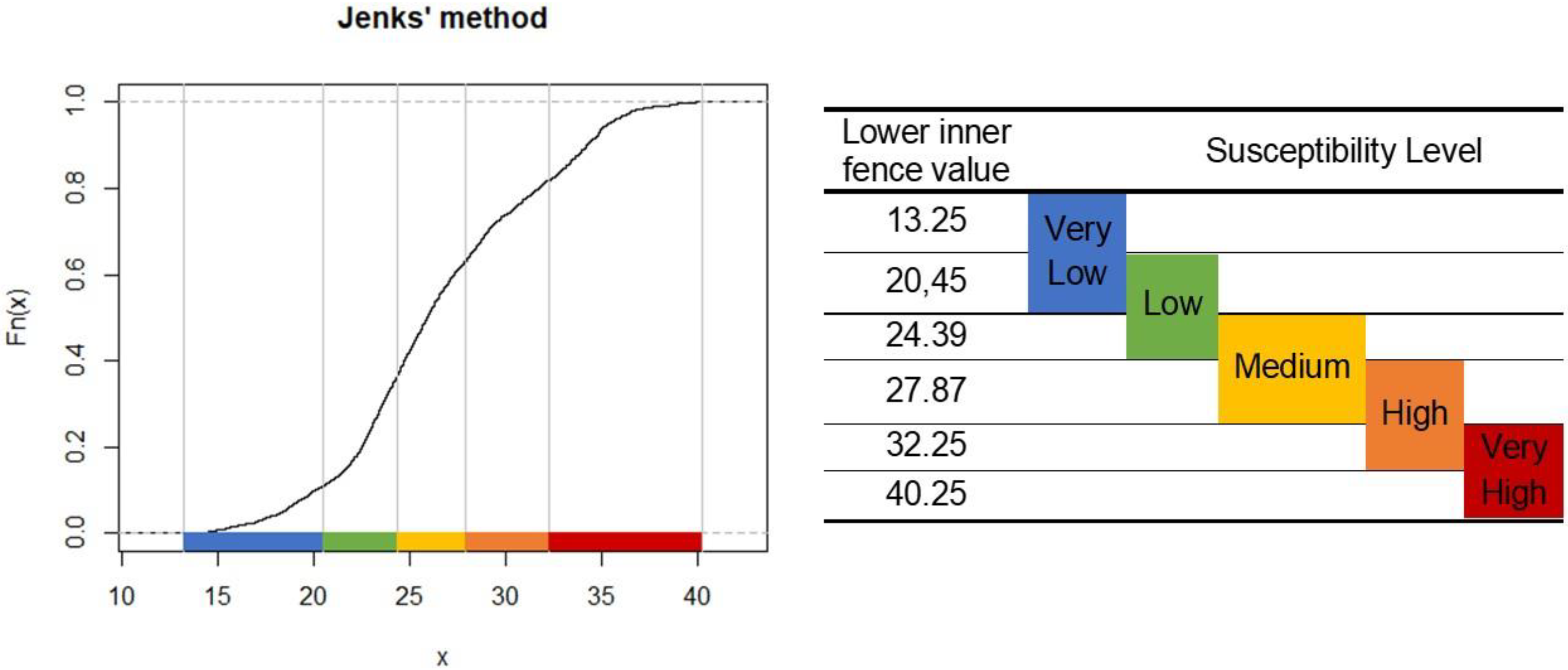
3.3. Susceptibility Database

Figure 3 illustrates the procedure used to obtain the susceptibility level of one interaction, according to the methodological approach presented by Pereira et al. [1]. The left column presents the nomenclature for values obtained through expert consultation for the importance of each one of the 21 processes on one littoral configuration. Likewise, the right column presents the nomenclature for values obtained through expert consultation for the affectation of one human intervention on each one of the 21 processes. Thus, the central column represents how the process disturbance is determined through the fuzzy system architecture. By this point, each one of the 21 processes has integrated a disturbance value from the two incoming streams of process affectation and importance. However, these values need to be further integrated through the weighted average of Table 1 to determine the susceptibility value of one type of configuration regarding the emplacement of a given intervention.
The SHIELD model, applied to a tropical coastal setting, was driven by 87 littoral configurations and 52 human interventions. This produced 4525 interactions. The single computed susceptibility value was accompanied by a matrix of the disturbance level associated with the 21 processes at each interaction (configuration/intervention). Therefore, a total of 95,004 disturbance levels were computed through fuzzy logic to articulate a database of process disturbances at each configuration/intervention interaction. As the susceptibility dataset does not describe a normal distribution, the five susceptibility levels of the SHIELD model were categorized through the Jenks natural breaks classification method [18,19]. Figure 4 depicts the empirical cumulative distribution function applied on the dataset from the ClassInt library of R® to define the limits of the classes where considerable differences arise between the data values. This way, similar values are grouped better and differences between classes are maximized to represent the natural groupings inherent in the data.

3.4. Control Panel for the Management of Environmental Impacts in Coastal Areas

According to the decision-making diagram for licensing authorities of Pereira et al. [1], the five ranges of estimated susceptibility in the SHIELD model works as thresholds to discern the level of environmental control required for an intervention at a certain location. Table 2 illustrates the use of SHIELD for coastal environments. It shows eight scenarios that may elicit the screening and scoping stages. The table reveals how disturbance levels are calculated in concert with specified processes to yield useful information for scoping. Comparing the first four scenarios illustrates the sort of information needed for various human interventions. Meanwhile, the last four scenarios indicate the variety of information needed for two types of interventions that impact the littoral environment. From this, it is clear that lower levels of susceptibility engender a reduced need to gather data to support the less intense licensing instruments required for interrogating the potential impact of human interventions.
Furthermore, the SHIELD model demonstrates adaptability in determining susceptibility for various environments, including those of the tropical coastline. The first four scenarios in Table 2 projected strong effects of dredging on submerged littoral configurations that have extensive biological communities (39MDS). In contrast, transporting fluids through pipelines (47CFP) reported the lowest susceptibility levels. Of course, this excluded disruptions from the initial construction of pipelines, and the potential for damaging leaks.
Dredging of channels for navigation (05MOC) is a high impact activity that compels an in-depth evaluation to address the multiple processes likely to sustain significant impact. Installation of luxury settlements (11AHU) necessitates a simple evaluation due to its relatively restricted affectation. The last four scenarios in Table 2 illustrate the response of different morphological configurations to similar interventions. A shoreside development for coastal tourists (12EDF) means there is an elevated susceptibility for emerged systems that lack cushioning features such as vegetated floodplains, or the wave-dissipation of a lagoon or river mouth. In the same fashion, building a marina (24MMN) will cause more damage to sandy systems colonized with an established biotic community than muddy ones.

4. Discussion

Considering the aim of this work, it is worth mentioning any differences with the original publication presenting the SHIELD model [1], which was a strictly theoretical work that offered a full disclosure of the generic version of the SHIELD model, from its conception as a solution to overcome current deficiencies in the screening and scoping stages of environmental impact assessment, to the methodological approaches used to operationalize it. In contrast, our study has illustrated the operation of the model, which involved the generation of new knowledge about coastal environments in the shape of never-before-seen interactions among geomorphological processes, landforms, and human interventions. Therefore, Pereira et al. [1] set the foundations to understand the conception of the SHIELD model, whereas the present work reconceptualizes the coastal environment from a geomorphological and ecosystem-based perspective to address the assessment of environmental impacts. In this sense, the following subsections offer insights about the coastal landforms configured in the SHIELD model, its interactions with geomorphological processes and human interventions, the computation strategy, and the corresponding challenges and opportunities.

4.1. Morphological Configurations of the SHIELD Model for Coastal Environments

Human interventions impact the geomorphology of an area, yet landform also influences human activity. That is, “intervention on morphological processes” examines the human impact, whereas considering the risks focuses on the landform’s effect on the integrity of the intervention [1,27]. The littoral configurations defined within the parameters of the SHIELD model adopts and enriches the pattern of combining geomorphological features posed by the Cuban Decree-Law 212 on coastal management, which is one of the few national regulations that differentiate coastal ecosystems [21,28]. Within the six types defined by this regulation, beaches are subclassified according to their combination with backing dunes, cliffs, and vegetation [20]. Although these compositions adequately represent the coastal environments typical of the tropics [6,29,30,31], other microenvironments have been suggested to complete the mix, such as lagoon systems and floodplains [21]. This work confirms the 11 emerged subunits defined to articulate the geomorphological configurations of the SHIELD model for tropical coastal environments [13,22]. The SHIELD model conforms well with the Cuban legal code that recognizes that effective coastal management requires consideration of the natural setting of the territory and the attendant risks associated with human interventions.
Both emerged and submerged littoral subunits defined in the parameters of the SHIELD model for tropical coastal environments align with natural geomorphological features. These include biogenic processes, such as bio-erosion or sediment fixation [32,33,34,35]. Both sandy and hard bottoms are altered and distinguished by biotic colonization, including corals, oysters, mussels, and seagrass. The biota also differentiates emerged units with coverage, such as the mangroves of the intertidal zone and creeping plants that stabilize dunes [35,36]. The SHIELD model incorporates these physical–biotic interactions. Susceptibility values for configurations of submerged subunits with a biogenic component present a consistent pattern. This speaks to the sensitivity of the ability of living organisms to respond to disruptions in natural dynamics [35,36,37,38]. Observed dissimilarities in such patterns may reflect the limited state of the current knowledge regarding the evolution of marine morphological features in the context of biogenic and lithological components. Including biota in the model is consistent with the ecosystem approach [1,39].
Traditionally, scientists focus on rates of erosion when considering coastal geomorphology [31,33,40,41]. The SHIELD model looks beyond that to include five additional categories to tailor the analysis to the true nature of the coastal environment. This includes understanding the interactive nature of human activity and landforms, which is essential for developing a suitable scoping approach [27,42].

4.2. Uncertainties Overcome by Fuzzy Algebra

Given the subjective nature of most accepted methods used in impact assessment, traditional approaches have been reinforced with fuzzy algebra to improve the prediction of impacts and capturing the ambiguity of the judgment values in linguistic variables [43,44]. In the validation of the SHIELD model for coastal environments, the membership functions and operation parameters were configured to include extreme values and gradual transitions of metrics for process disturbance. Furthermore, the Mardani inference method informed the model, as it is well-established for human inputs [25]. The breadth defined for the fuzzy sets aligned with the directions provided for the experts taking part in the surveys, through a question with a sliding bar. The inference rules follow the logic of environmental impact by indicating that the affectation of a process prevails over its importance. Therefore, preliminary assessment of impact significance emulates the SHIELD model methodology that integrates fuzzy logic as a strategy to apply expert judgement to the synthesis and interpretation of the targeted environmental setting.
The fuzzy sets theory is effective for quantifying systems based on expert knowledge because it is closer to human reasoning than the classic bivalent logic [45]. Instead of generalizing linguistic variables though plain binary sets (e.g., Yes/No), fuzzy algebra uses multiple degrees of membership to several intervals for approaching concepts without exact frontiers [46,47]. In this sense, the natural language used to ask the experts to rate process affectation and importance (e.g., Irrelevant-Low-Medium-High-Determinant) represents the fuzzy boundaries of the set for which expert qualifications do or do not belong. Also, fuzzy logic helps overcome the difficulties in assessing the dynamic nature of geomorphological processes [48]. The linguistic aspect of fuzzy logic addresses the uncertainties linked to assessing the response of geomorphological processes to human disturbances.
Another uncertainty managed through fuzzy algebra is the imprecise human nature of expert opinions. Individuals may render various judgments of an event because of subjective perceptions or differences in personalities, even when using nearly identical language [25]. Most properties used to access the environment align with somewhat vague representations bounded by inexact boundaries. Linguistic variables capture this reality while providing a system for mathematical interpretation [44]. This is at the core of the SHIELD model.

4.3. Challenges and Opportunities for a Systematic Application of the SHIELD Model in Tropical Coastal Environments

An application of the SHIELD model for coastal environments in a specific geographical area would involve the collection of geomorphological and ecosystem maps to categorize the existing landforms in the emerged and submerged features of the littoral configurations set in the coastal SHIELD parameters. Then, existing and projected human interventions could be overlapped with the categorized littoral configurations to set the susceptibility levels resulting from the cross reference. For each configuration, the database of coastal SHIELD can be organized, as illustrated in Table 2, to represent the types of interventions interacting in the littoral configuration, implicit susceptibility levels, and the information requirements for the geomorphological processes during an impact assessment and subsequent follow-ups. A case study of this application could offer further insights on territorial planning perspectives of the appointed geographical area.
The knowledge base for understanding some of the processes impacting the coastal environment is limited [8,48]. This limitation restricts the ability to embrace more dynamic representation of processes for informing management practices. Advancing management effectiveness requires the collection of specified data for building dynamic models. This means adopting technical guidelines that incorporate temporal and spatial elements [14,42]. The validation of the model would require a multi-temporal study that allows correlation of the outcomes of the SHIELD model with the various types of licensing instruments in a geographical area.
A strength of the SHIELD model is its fixability in accommodating various data processing tools. Furthermore, the customization of the SHIELD model is subject to improvements through the articulation of data processing instruments in its architecture. Neuronal webs, multivariate statistics, and advanced methods for computing transitions could enhance SHIELD [49,50]. Artificial intelligence applied to a neuro-diffuse approach would develop the model into a system that is trainable from past experiences (e.g., records of approved and denied licenses/permits). Multivariate techniques of information consolidation, such as principal components analysis or stepwise regression, could assemble the various disturbance levels of geomorphological processes into a single susceptibility value. The statistical multivariate approach could supplant or support the fuzzy logic algorithms presently used in SHIELD. Without a doubt, the addition of data processing instruments that bring sophistication and conciseness to the SHIELD model will enhance its overall effectiveness.
Addressing the size, orientation, and location of physiographic units (littoral cells) can also improve the versatility of the SHIELD model [5,6]. Coastal dunes serve as a savings bank of sediment for an eroding beach [36,51,52]. As such, adjacent littoral configurations figure into the processes impacting any particular area [53,54,55,56]. Assembling interconnected littoral configurations into coastal compartments could yield better estimates of susceptibility for management purposes [57,58,59,60,61] and lead to more informed decision-making.
The flexibility of the SHIELD model permits its constant improvement as more information becomes available for locations undergoing evaluation. Examples of such improvements include better accounting for normal and exceptional tidal excursions, delineating the landward extent of marine influence in large coastal wetlands, more detailed nearshore seafloor mapping, distinguishing lithological and biogenic hard substratum, and up-to-date charting of offshore bars, stacks, and similar features. This additional information will improve environmental assessment and help establish geoindicators useful for understanding coastal systems worldwide.
Lastly, this application of SHIELD presented for coastal environments could be a useful guide to researchers studying other kinds of environments or coastal areas around the world. Tropical areas are recognized for their high biodiversity, caused by the constant input of solar energy all year round [62,63,64]. Of course, application of the SHIELD model in systems ranging from tropical to polar areas will need to check the natural dynamic of the 21 geomorphological processes and calibrate the weights of the disturbance levels according to the particular location. Moreover, the morphological configurations should be adjusted to the particularities of the kind of environment where the SHIELD model will be applied. In sum, this paper works as a path to follow for future adaptations of this novel model of susceptibility for environmental impacts.

5. Conclusions

This research showed how a geomorphological perspective can be converted to a technical criterion-based-system for enhancing environmental licensing procedures in tropical coastal areas. We developed a database of susceptibility and process disturbance levels, including 87 types of littoral configurations for the interaction of 52 potential interventions. Moreover, a comprehensive list of 21 geomorphological processes were defined and applied to run the fuzzy logic algebra of the model. On the other hand, the SHIELD model has the potential to produce a database useful for creating an articulated inventory that can be applied to the various ecosystems in a certain area. Indeed, the methodology described here can also be tailored to access a wide range of environments and latitudes (e.g., dry forests, wet jungles, continental wetlands, mountains, valleys, prairie, deserts, and plateaus).
Nevertheless, further research is needed to conceptualize the general parameters for a specific environment, namely an array of relevant processes, morphological configurations, and pertinent human interventions. It means carefully checking all SHIELD parameters to understand the differences in our adaptation to tropical coastal areas that is presented here. Another limitation is related to the expert criteria used to define weights of the disturbance levels, because it depends on the knowledge and experience of a small group of people. Although the fuzzy logic significantly reduces the uncertainties and subjectivity of expert evaluations, there is room for more improvements.
Finally, this research provides a tailored tool for tropical coastal environments that can shift the environmental licensing framework to one focused on responding to types of human interventions (anthropogenic approach), or to one based on the geomorphology for appropriate monitoring and decision-making (ecocentric approach). The challenge for future research and implementations will be to maintain the susceptibility of the SHIELD model, even when used in other geographical areas or environments. As this perspective goes beyond research and is applied to licensing procedures, a new way to evaluate environmental impacts that takes into account the dynamic nature of the planet will be available.

Author Contributions

C.I.P.: formulation of the general idea of the research and its coordination; design and test of the SHIELD parameters, model matrices, and susceptibility database; design of the control panel; C.I.P., O.C. and C.M.B.: design and revision of the methods, including the fuzzy algebra; C.I.P., C.M.B. and C.B.M.: conceptualization of environmental license procedure; C.R.-V., O.C. and D.M.: conceptualization of the geomorphological processes; C.I.P., C.M.B., C.B.M. and B.C.: writing and reviewing the style of the article. All authors have read and agreed to the published version of the manuscript.

Funding

Partial financial support for this research was provided to the second author from Sergio Arboleda University within the IV internal research announcement “La Sergio 4.0”. The last author thanks Universidad de la Costa for supporting her postdoctoral project as a funder. The funding was carried out by the project INDEX No.INV.1106-01-007-12, named “Resilient cities: minimizing vulnerabilities when facing extreme meteorological phenomena and climate changes at coastal communities”.

Institutional Review Board Statement

Not applicable.

Informed Consent Statement

Not applicable. The study did not involve humans or animals.

Data Availability Statement

Data are confidential.

Acknowledgments

Three authors of this paper are members of the Ibero-American Beach Management and Certification Network (PROPLAYAS). C.I.P.; C.M.B. and C.B.M.thank this Network.

Conflicts of Interest

The authors declare that they have no known competing financial interests or personal relationships that could have appeared to influence the work reported in this paper.

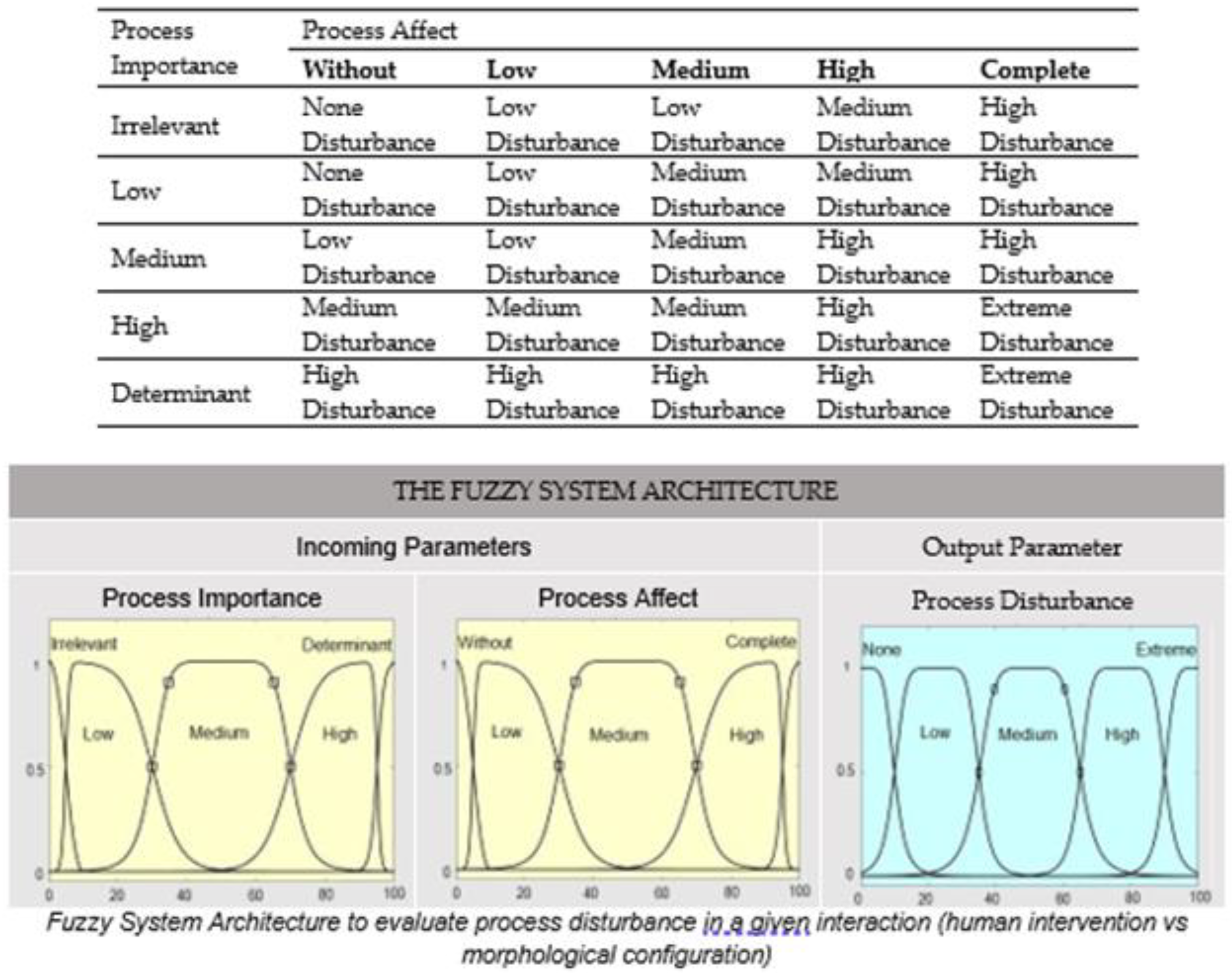
Appendix A. Parameters of the Fuzzy System Algorithm of SHIELD Model

The parameters of the fuzzy system algorithm were set from the fuzzy logic toolbox of MATLAB (MATLAB 9.2., 2017), as follows:
-
Inference method: Mamdani
-
Incoming parameters: 2, Process Importance and Process Affect
-
Output parameter: 1, Process Disturbance
-
Linguistic rules: a total of 25 rules defined by the form “IF X AND Y THEN Z”, where X, Y, and Z represent fuzzy sets (see Table 1).
-
Membership functions for diffuse sets: combination of generalized and sigmoidally-shaped bells for the incoming parameters and a generalized bell for the output parameter. Figure 2 represents the corresponding fuzzy sets distribution.
-
Mathematical operators: for the rules and implication aggregation, there was ‘minimum’. For union aggregation, there was ‘cumulative sum’. For numeric score generation, there was ‘Largest-of-Maximum-of-the-Area technique’ (“lom”).
Figure A1. Inference rules of the fuzzy logic system defined for coastal environments.
Sustainability 14 12317 g0a1

Appendix B. Parameters of the SHIELD Model for Tropical Coastal Environments
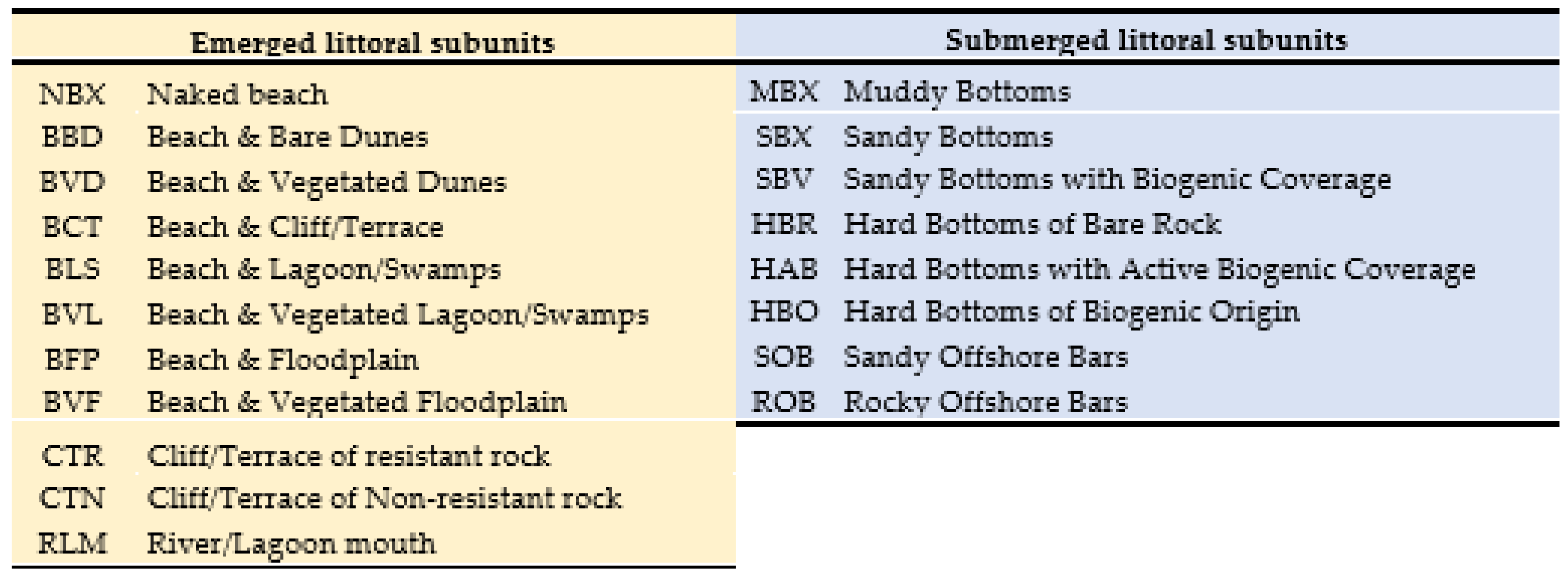
Table A1. List of processes defined for the SHIELD model applied to coastal environments.
CategoryProcessCode
GeologicalSubsidence by sediment compactionP1
Vertical movements associated to diapirismP2
Earth movements by neo-tectonicsP3
Physical weathering by structural controlsP4
Littoral mass movementsP5
Erosion in the drainage basin (sediment inputs)P6
Sediment sinking by geomorphologic configurationP7
Water table changesP8
GeochemicalChemical formation of sedimentsP9
Chemical weatheringP10
ClimaticEustatic sea level changesP11
Semi-periodic sea level changesP12
Extreme meteorological eventsP13
Drainage in the basin by weather eventsP14
HydrodynamicLittoral erosionP15
Littoral sediment transportP16
Littoral depositionP17
EolicWave generation by windP18
Sediment transport and deposition by windP19
BiogenicBiogenic sediment productionP20
Sediment fixationP21
Figure A2. Emerged and submerged morphological compositions for setting littoral configurations.
Sustainability 14 12317 g0a2
Table A2. List of human interventions defined for the SHIELD model applied to coastal environments.
CategoryCodeInterventionCategoryCodeIntervention
Drainage basin alterations02UGMUnderground water movementExtensive land use and livestock33UAGLivestock, farming and golf course
03IDOIrrigation districts34GMRMariculture
04LUCChanges in land use (deforestation)35GRAAquaculture
05MOCModification of channels 36TPCThematic parks and camping
07IFCInstallations in fluvial causesExtractive activities38EEHExploration/extraction of hydrocarbons
Edifications08AHBLow density settlements39MDSMarine dredging
09AHAHigh-density settlements40RDSRiver dredging
10AHPPalatial settlementsLinear infrastructure41CAPRoads, double roads, bridges...
11AHULuxury settlements42VFERailways and facilities
12EDF Sun, Sea and Sand Tourism 43CAPTunnels
13MILMilitary installations on land44CAPAirports and runways
Marine navigation and facilities14EMPInlet navigation channels45ELFElectric lines and facilities
15MUPPublic Docks46BSPBasic sanitation pipes
16AHMLuxury settlement with pier47CFPConduction of fluids through pipelines
17EDMSun, Sea and Sand tourism with pierWorks of shore protection and control48ROPBreakwaters and artificial reefs
18PUC Deepwater ports without shelter49CYPGroins
19PUGShallow water ports without shelter50MUR Sea walls, walks, and ridges
20SPSSheltered ports51BNSBeach nourishment
21FFFFishingBasic sanitation facilities52DSPDesalination plants
22INANaval military installations53SWDSolid waste exploitation and disposal
23NAVInternal Maritime Transport54SMESubmarine emissary
24MMNMarinas55WTPWastewater treatment plants
Industrial and energy installations26GTPGeothermal plants
27WPPWind power plants
28SEPSolar energy plants
29TYSThermoelectric plants
30TSFTransformation/storage of fossil fuel
31MANManufacture
32GSTGeological storage
Note: Interventions 01, 06, 25, and 37 were excluded within the expert’s workshops.

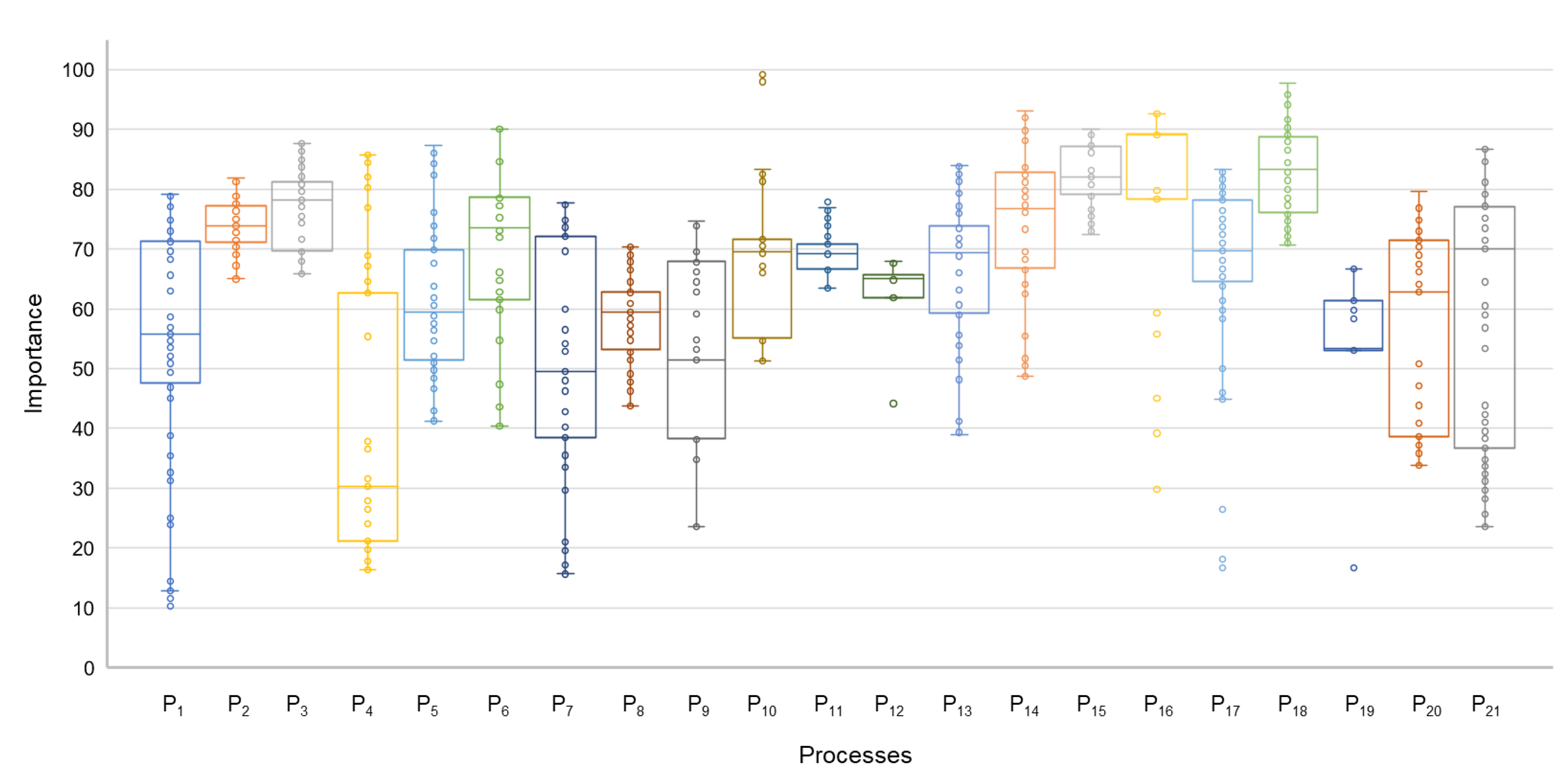
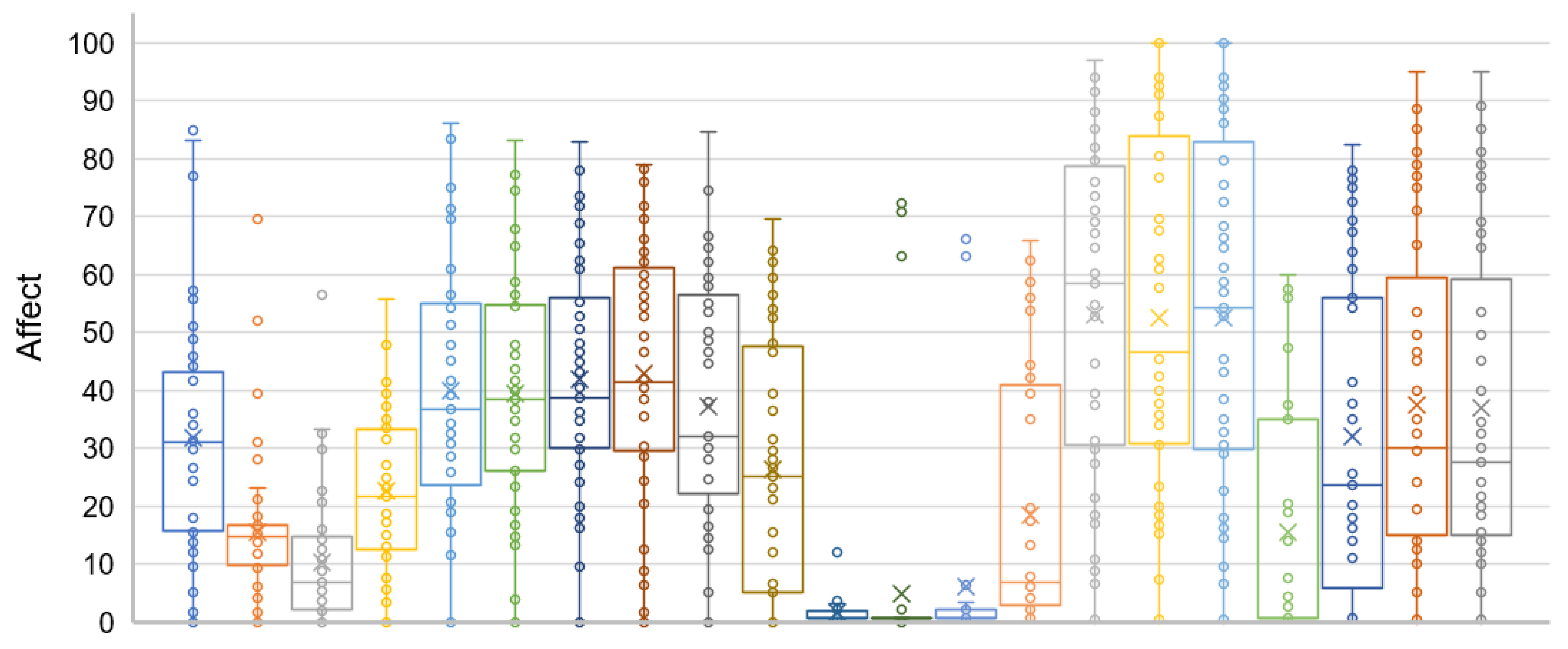
Appendix C. Boxplots of Tropical Coastal Processes within the SHIELD Model

Figure A3. Boxplot of importance values set by processes in the importance matrix.
Sustainability 14 12317 g0a3
Figure A4. Boxplot of affect values set by processes in the affect matrix.
Sustainability 14 12317 g0a4

References

  1. Pereira, C.I.; Milanes, C.B.; Correa, I.; Pranzini, E.; Cuker, B.; Botero, C.M. A Geomorphological Model of Susceptibility to the Effect of Human Interventions for Environmental Licensing Determination (SHIELD). Geosci. Front. 2022, 13, 101343. [Google Scholar] [CrossRef]
  2. Weston, J. EIA, Decision-Making Theory and Screening and Scoping in UK Practice. J. Environ. Plan. Manag. 2000, 43, 185–203. [Google Scholar] [CrossRef]
  3. Kelletat, D.H. Atlas of Coastal Geomorphology and Zonality. J. Coast. Res. 1995, 1–300. [Google Scholar]
  4. Gutierrez, M. Geomorfología; Pearson: Madrid, Spain, 2008. [Google Scholar]
  5. Masselink, G.; Hughes, M.G.; Knight, J. Introduction to Coastal Processes and Geomorphology; Hodder Education: London, UK, 2011; ISBN 9781444122404. [Google Scholar]
  6. Pranzini, E. La Foma Delle Coste—Geomorfologia Costiera Impatto Antropico e Difesa Dei Litorali, 5th ed.; Zanichello Editore S.p.A.: Bologna, Italy, 2004. [Google Scholar]
  7. Sorensen, R.M. Basic Coastal Engineering, 3rd ed.; Springer: New York, NY, USA, 2006. [Google Scholar]
  8. Bird, E. Coastal Geomorphology. An Introduction, 2nd ed.; John Wiley & Sons: West Sussex, UK, 2008; ISBN 9780874216561. [Google Scholar]
  9. Davidson-Arnott, R. Introduction to Coastal Processes and Geomorphology; Cambridge University Press: Cambridge, UK, 2010; ISBN 978-0-521-87445-8. [Google Scholar]
  10. Bush, D.; Pilkey, O.; Neal, W. Coastal Topography, Human Impact On. Encycl. Ocean Sci. 2001, 480–489. [Google Scholar]
  11. Anfuso, G.; Martínez-del-Pozo, J.Á.; Rangel-Buitrago, N. Bad Practice in Erosion Management: The Southern Sicily Case Study. In Pitfalls of Shoreline Stabilization: Selected Case Studies; Cooper, G.J.A., Pilkey, H.O., Eds.; Springer: Dordrecht, The Netherlands, 2012; pp. 215–233. ISBN 978-94-007-4123-2. [Google Scholar]
  12. Williams, A.T.; Rangel-Buitrago, N.; Pranzini, E.; Anfuso, G. The Management of Coastal Erosion. Ocean Coast. Manag. 2018, 156, 4–20. [Google Scholar] [CrossRef]
  13. Milanes, C. Coastal Boundaries; Finkl, C., Makowski, C., Eds.; Springer International Publishing AG: New York, NY, USA, 2018. [Google Scholar]
  14. Pereira, C.I.; Botero, C.M.; Correa, I.; Pranzini, E. Seven Good Practices for the Environmental Licensing of Coastal Interventions: Lessons from the Italian, Cuban, Spanish and Colombian Regulatory Frameworks and Insights on Coastal Processes. Environ. Impact Assess. Rev. 2018, 73, 20–30. [Google Scholar] [CrossRef]
  15. Morton, R.; Pieper, M. Shoreline Changes in Mustang Island and North Padre Island (Aransas Pass to Yarborough). Geol. Circ. 1977, 77, 45. [Google Scholar]
  16. Prothero, D.; Schwab, F. Sedimentary Geology—An Introduction to Sedimentary Rocks and Stratigraphy, 3rd ed.; W. H. Freeman and Company: New York, NY, USA, 2013. [Google Scholar]
  17. Brito, I. The Environmental Control in the Coastal Zone; University of Santa Clara: Santa Clara, Cuba, 2012. (In Spanish) [Google Scholar]
  18. Fairbridge, R. Classification of Coasts. J. Coast. Res. 2004, 20, 155–165. [Google Scholar] [CrossRef]
  19. Finkl, C. Coastal Classification: Systematic Approaches to Consider in the Development of a Comprehensive Scheme. J. Coast. Res. 2004, 20, 166–213. [Google Scholar] [CrossRef]
  20. GORC (Official Journal od the Cuban Republic). Decree-Law 212 of The Coastal Zone Management; Asamblea Nacional del Poder Popular, Palacio de las Convenciones: Havana, Cuba, 2000; p. 12. (In Spanish) [Google Scholar]
  21. Milanes, C.; Pereira, C.I.; Botero, C.M. Improving a Decree Law about Coastal Zone Management in a Small Island Developing State: The Case of Cuba. Mar. Policy 2019, 101, 93–107. [Google Scholar] [CrossRef]
  22. Barragan, J.M. Medio Ambiente y Desarrollo En Areas Littorales; Servicio de Publicaciones, U., Ed.; Servicio de Publicaciones, Universidad de Cadiz: Cadiz, Spain, 2003. [Google Scholar]
  23. Botero, C.M.; Tosic, M.; Calderón, H.; Niño, D. Ordenamiento Del Golfo de Cupica (Pacífico Colombiano) Como Ejemplo de Gestión Costera Integrada a Escala Local. Boletín Científico CIOH 2014, 32, 105–122. [Google Scholar] [CrossRef]
  24. Pereira, C.I. Analysis of the Environmental Licensing Procedure for Coastal Environments in Colombia: A Geomorphological Perspective from the Concept of Susceptibility to the Effect of Human Interventions. Ph.D. Thesis, EAFIT University, Medellín, Colombia, 2019. [Google Scholar]
  25. Mardani, A.; Jusoh, A.; Zavadskas, E.K. Fuzzy Multiple Criteria Decision-Making Techniques and Applications—Two Decades Review from 1994 to 2014. Expert Syst. Appl. 2015, 42, 4126–4148. [Google Scholar] [CrossRef]
  26. Forman, R.T.T. Land Mosaics: The Ecology of Landscapes and Regions; Cambridge University Press: Cambridge, UK, 1995. [Google Scholar]
  27. Cavallin, A.; Marchetti, M.; Panizza, M.; Soldati, M. The Role of Geomorphology in Environmental Impact Assessment. Geomorphology 1994, 9, 143–153. [Google Scholar] [CrossRef]
  28. Pereira, C.I.; Madrid, D.A.; Correa, I.D.; Pranzini, E.; Botero, C.M. An Evaluation of Human Interventions in the Anthropogenically Disturbed Caribbean Coast of Colombia. Anthropocene 2019, 27, 100215. [Google Scholar] [CrossRef]
  29. Alcántara, J.; Fontan, A.; Albarracin, S.; Correa, I.; MNontoya, I.; Manriques, M. Geomorphological Coastal Classification after Natural Processes and Human Disturbance. Oceanography 2014, 2, e108. [Google Scholar] [CrossRef]
  30. Correa, I.; Morton, R. Caribbean Coast of Colombia. In Encyclopedia of the World’s Coastal Landforms; Bird, E.F., Ed.; Springer: Dordrecht, The Netherlands, 2010; pp. 259–264. ISBN 978-1-4020-8638-0. [Google Scholar]
  31. Paniagua-Arroyave, J.F.; Correa, I.D.; Anfuso, G.; Adams, P.N. Soft-Cliff Retreat in a Tropical Coast: The Minuto de Dios Sector, Caribbean Coast of Colombia. J. Coast. Res. 2018, 40–49. [Google Scholar] [CrossRef]
  32. Butler, D.R.; Hupp, C.R. 12.1 The Role of Biota in Geomorphology: Ecogeomorphology; Shroder, J., Butler, D.R., Hupp, C.R., Eds.; Academic Press: San Diego, CA, USA, 2013; pp. 1–5. ISBN 978-0-08-088522-3. [Google Scholar]
  33. Cobo-Viveros, A.M.; Cantera-Kintz, J.R. Main Factors Determining Bioerosion Patterns on Rocky Cliffs in a Drowned Valley Estuary in the Colombian Pacific (Eastern Tropical Pacific). Geomorphology 2015, 246, 220–231. [Google Scholar] [CrossRef]
  34. Gracia, A.; Rangel-Buitrago, N.; Oakley, J.A.; Williams, A.T. Use of Ecosystems in Coastal Erosion Management. Ocean Coast. Manag. 2018, 156, 277–289. [Google Scholar] [CrossRef]
  35. Willemsen, P.W.J.M.; Horstman, E.M.; Borsje, B.W.; Friess, D.A.; Dohmen-Janssen, C.M. Sensitivity of the Sediment Trapping Capacity of an Estuarine Mangrove Forest. Geomorphology 2016, 273, 189–201. [Google Scholar] [CrossRef]
  36. Martínez, M.L.; Gallego-Fernández, J.B.; García-Franco, J.G.; Moctezuma, C.; Jiménez, C.D. Assessment of Coastal Dune Vulnerability to Natural and Anthropogenic Disturbances along the Gulf of Mexico. Environ. Conserv. 2006, 33, 109–117. [Google Scholar] [CrossRef]
  37. Goudie, A. The Human Impact in Geomorphology—50 Years of Change. Geomorphology 2018, 366, 106601. [Google Scholar] [CrossRef]
  38. Ramos, E.; Díaz de Terán, J.R.; Puente, A.; Juanes, J.A. The Role of Geomorphology in the Distribution of Intertidal Rocky Macroalgae in the NE Atlantic Region. Estuar. Coast. Shelf Sci. 2016, 179, 90–98. [Google Scholar] [CrossRef]
  39. Sarda, R.; O’Higgins, T.; Cormier, R.; Diedrich, A.; Tintore, J. A Proposed Ecosystem-Based Management System for Marine Waters: Linking the Theory of Environmental Policy to the Practice of Environmental Management. Ecol. Soc. 2014, 19, 51. [Google Scholar] [CrossRef] [Green Version]
  40. Mclaughlin, S.; Cooper, J.A.G. A Multi-Scale Coastal Vulnerability Index: A Tool for Coastal Managers? Environ. Hazards 2010, 9, 233–248. [Google Scholar] [CrossRef]
  41. Reinen-Hamil, R.; Hegan, B.; Shand, T. Regional Assessment of Areas Susceptible to Coastal Erosion; Auckland Regional Council: Auckland, New Zealand, 2009; Volume 1. [Google Scholar]
  42. Pereira, C.I.; Milanes, C.B.; Sarda, R.; Cuker, B.; Botero, C.M. Challenges at the Early Stages of the Environmental Licensing Procedure and Potential Contributions from Geomorphology. Geosci. Front. 2021, 12, 101228. [Google Scholar] [CrossRef]
  43. Loomis, J.J.; Dziedzic, M. Evaluating EIA Systems’ Effectiveness: A State of the Art. Environ. Impact Assess. Rev. 2018, 68, 29–37. [Google Scholar] [CrossRef]
  44. Peche, R.; Rodríguez, E. Environmental Impact Assessment by Means of a Procedure Based on Fuzzy Logic: A Practical Application. Environ. Impact Assess. Rev. 2011, 31, 87–96. [Google Scholar] [CrossRef]
  45. Besné, A.G.; Luna, D.; Cobos, A.; Lameiras, D.; Ortiz-Moreno, H.; Güereca, L.P. A Methodological Framework of Eco-Efficiency Based on Fuzzy Logic and Life Cycle Assessment Applied to a Mexican SME. Environ. Impact Assess. Rev. 2018, 68, 38–48. [Google Scholar] [CrossRef]
  46. Canavese, D.; Ortega, N.R.S.; Queirós, M. The Assessment of Local Sustainability Using Fuzzy Logic: An Expert Opinion System to Evaluate Environmental Sanitation in the Algarve Region, Portugal. Ecol. Indic. 2014, 36, 711–718. [Google Scholar] [CrossRef]
  47. Liu, K.F.R.; Lai, J.-H. Decision-Support for Environmental Impact Assessment: A Hybrid Approach Using Fuzzy Logic and Fuzzy Analytic Network Process. Expert Syst. Appl. 2009, 36, 5119–5136. [Google Scholar] [CrossRef]
  48. Rivas, V.; Rix, K.; Frances, E.; Cendrero, A.; Brunsden, D. Geomorphological Indicators for Environmental Impact Assessment: Consumable and Non-Consumable Geomorphological Resources. Geomorphology 1997, 18, 169–182. [Google Scholar] [CrossRef]
  49. Castley, J.G.; Bezuidenhout, H.; Knight, M.H. Searching for Common Ground, a Scientific Approach to Subjective Environmental Impact Assessments: An Example from the Kgalagadi Transfrontier Park. Koedoe 2003, 46, 107–114. [Google Scholar] [CrossRef]
  50. Robles, C.; Polo, A.; Ospino, A. An Analytic Hierarchy Process Based Approach for Evaluating Renewable Energy Sources. Int. J. Energy Econ. Policy 2017, 7, 38–47. [Google Scholar]
  51. Davidson-Arnott, R.G.D. Conceptual Model of the Effects of Sea Level Rise on Sandy Coasts. J. Coast. Res. 2005, 21, 1166–1172. [Google Scholar] [CrossRef] [Green Version]
  52. Gomez, J.F.; Byrne, M.-L.; Hamilton, J.; Federico, I. Historical Coastal Evolution and Dune Vegetation in Isla Salamanca National Park, Colombia. J. Coast. Res. 2017, 33, 632–641. [Google Scholar] [CrossRef]
  53. Anfuso, G.; Martínez-del-Pozo, J.Á.; Rangel-Buitrago, N. Morphological Cells in the Ragusa Littoral (Sicily, Italy). J. Coast. Conserv. 2013, 17, 369–377. [Google Scholar] [CrossRef]
  54. Anfuso, G.; Pranzini, E.; Vitale, G. An Integrated Approach to Coastal Erosion Problems in Northern Tuscany (Italy): Littoral Morphological Evolution and Cell Distribution. Geomorphology 2011, 129, 204–214. [Google Scholar] [CrossRef]
  55. Bezzi, A.; Pillon, S.; Martinucci, D.; Fontolan, G. Inventory and Conservation Assessment for the Management of Coastal Dunes, Veneto Coasts, Italy. J. Coast. Conserv. 2018, 22, 503–518. [Google Scholar] [CrossRef]
  56. Inman, D. Littoral Cells. In Encyclopedia of Coastal Science; Springer: New York, NY, USA, 2005; pp. 594–599. [Google Scholar]
  57. Jackson, C.W.; Bush, D.; Neal, W. The Coastal Compartment Management Plan: Using Puerto Rico as a Model. Southeast. Geol. 2009, 46, 69–84. [Google Scholar]
  58. Liguria, R. Piano Di Tutela Dell’ambiente Marino e Costiero. Available online: http://www.ambienteinliguria.it/lirgw/eco3/ep/linkPagina.do?canale=/Home/030acque/030marecosta/010competenzeRLacquemarine/040pianotutelaambientemarinocostiero (accessed on 25 January 2018).
  59. MATTM-Regioni. Linee Guida per La Difesa Della Costa Dai Fenomeni Di Erosione e Dagli Effetti Dei Cambiamenti Climatici. In Documento Elaborato Dal Tavolo Nazionale Sull’Erosione Costiera MATTM-Regioni Con Il Coordiamento Tecnico Di Ispra; MATTM-Regioni: Rome, Italy, 2017; p. 309. [Google Scholar]
  60. Montanari, R.; Marasmi, C. Il Sistema Gestionale Delle Celle Litoranee SICELL—Aggiornamento 2006–2012; Bologna, Italy, 2014. [Google Scholar]
  61. Thom, B.; Eliot, I.; Eliot, M.; Harvey, N.; Rissik, D.; Sharples, C.; Short, C.; Woodroffe, C. National Sediment Compartment Framework for Australian Coastal Management. Ocean Coast. Manag. Manag. 2018, 154, 103–120. [Google Scholar] [CrossRef]
  62. Milanes Batista, C.M.; Planas, J.A.; Pelot, R.; Núñez, J.R. A new methodology incorporating public participation within Cuba’s ICZM program. Ocean Coast. Manag. 2020, 186, 105101. [Google Scholar] [CrossRef]
  63. Moreno, C.; Milanes, C.B.; Arguello, W.; Fontalvo, A.; Alvarez, R.N. Challenges and perspectives of the use of photovoltaic solar energy in Colombia. Int. J. Electr. Comput. Eng. 2022, 12, 4521–4528. [Google Scholar] [CrossRef]
  64. Rodríguez Gámez, M.; Vázquez Pérez, A.; Torres Pérez, M.; Núñez Alvarez, J.R. Local development applied to the energy scheme using the geographic information system for decision making. Int. J. Electr. Comput. Eng. 2022, 12, 3343. [Google Scholar] [CrossRef]
Figure 1. Methodological path to customize the SHIELD model for tropical coastal environments.
Sustainability 14 12317 g001
Figure 2. Customized parameters of the SHIELD model for tropical coastal environments.
Sustainability 14 12317 g002
Figure 3. Demonstration of the procedure used to apply the SHIELD model architecture in one interaction with the parameters of tropical coastal environments.
Sustainability 14 12317 g003
Figure 4. Main descriptors of the susceptibility data set and equivalent ranges for susceptibility levels.
Sustainability 14 12317 g004
Table 1. Weights of the disturbance levels and the equation to integrate them into a susceptibility value.
Range ValueDisturbance
Level
WeightSusceptibility
0–10None1                                         P n i j     w e i g h t n     5
  P n i j   = Disturbance level of the n process in the interaction of the intervention i on the littoral configuration j .
10.01–35Low2
35.01–65Medium3
65.01–90High4
90.01–100Extreme5
Table 2. Information levels required from each process (Pn) in the environmental impact study (EIS), according to the type of licensing instrument. (Doc. Review stands for documental revision of external data; Model (Doc.) stands for modelling or simulation with documental data; Field Data stands for data collection through field surveys; and Model (Field) stands for modelling or simulation with field data. Adapted from Pereira (2019).
Scenarios 1 to 4: Information Required for Different Human Interventions regarding One Type of Littoral Configuration
Environmental Licensing InstrumentInteractionGEOLOGICGEO-CHEMICALCLIMATICHYDRODYNAMICEOLICBIOGENIC
Inter-ventionLittoral configurationP1P2P3P4P5P6P7P8P9P10P11P12P13P14P15P16P17P18P19P20P21
Regional AuthorityEnvironmental Management Plan47CFP29-BFP-SBVDoc. ReviewDoc. ReviewDoc. ReviewDoc. ReviewDoc. ReviewDoc. ReviewDoc. ReviewDoc. ReviewDoc. ReviewDoc. ReviewDoc. ReviewDoc. ReviewDoc. ReviewDoc. ReviewDoc. ReviewDoc. ReviewDoc. ReviewDoc. ReviewDoc. ReviewDoc. ReviewDoc. Review
Perturbation levelMediumMediumMediumLowMediumMediumMediumMediumMediumMediumLowLowMediumMediumMediumMediumMediumMediumLowLowMedium
Simplified EIS11AHU29-BFP-SBVModel (Doc.)Model (Doc.)Model (Doc.)Doc. ReviewDoc. ReviewModel (Doc.)Field dataModel (Doc.)Doc. ReviewDoc. ReviewDoc. ReviewDoc. ReviewModel (Doc.)Model (Doc.)Model (Doc.)Model (Doc.)Model (Doc.)Model (Doc.)Model (Doc.)Doc. ReviewModel (Doc.)
Perturbation levelMediumMediumMediumLowLowMediumHighMediumLowLowLowLowMediumMediumMediumMediumMediumMediumMediumLowMedium
National AuthorityRobust EIS05MOC29-BFP-SBVModel (Field)Field dataField dataField dataField dataModel (Field)Field dataModel (Field)Field dataField dataDoc. ReviewDoc. ReviewField dataField dataField dataField dataField dataField dataDoc. ReviewModel (Field)Field data
Perturbation levelHighMediumMediumMediumMediumHighMediumHighMediumMediumLowLowMediumMediumMediumMediumMediumMediumLowHighMedium
Alternative Analysis39MDS29-BFP-SBVField dataField dataField dataField dataModel (Field)Field dataModel (Field)Field dataField dataField dataField dataField dataField dataField dataModel (Field)Model (Field)Model (Field)Field dataField dataModel (Field)Model (Field)
Perturbation levelMediumMediumMediumLowHighMediumHighMediumMediumMediumLowLowMediumMediumHighHighHighMediumLowHighHigh
Scenarios 5 to 8: Information Requirements for Two Related Types of Interventions regarding Different Littoral Configurations
Environmental Licensing InstrumentInteractionGEOLOGICGEO-CHEMICALCLIMATICHYDRODYNAMICEOLICBIOGENIC
Inter-ventionLittoral configurationP1P2P3P4P5P6P7P8P9P10P11P12P13P14P15P16P17P18P19P20P21
Regional AuthorityEnvironmental Management Plan12EDF23-NBX-SBVDoc. ReviewDoc. ReviewDoc. ReviewDoc. ReviewDoc. ReviewDoc. ReviewDoc. ReviewDoc. ReviewDoc. ReviewDoc. ReviewDoc. ReviewDoc. ReviewDoc. ReviewDoc. ReviewDoc. ReviewDoc. ReviewDoc. ReviewDoc. ReviewDoc. ReviewDoc. ReviewDoc. Review
Perturbation levelMediumMediumMediumLowMediumMediumMediumMediumLowLowLowLowMediumMediumMediumMediumMediumMediumLowMediumMedium
Simplified EIS12EDF33-RLM-SBVModel (Doc.)Model (Doc.)Model (Doc.)Doc. ReviewModel (Doc.)Model (Doc.)Model (Doc.)Model (Doc.)Doc. ReviewDoc. ReviewDoc. ReviewDoc. ReviewModel (Doc.)Model (Doc.)Model (Doc.)Model (Doc.)Model (Doc.)Field dataDoc. ReviewModel (Doc.)Model (Doc.)
Perturbation levelMediumMediumMediumLowMediumMediumMediumMediumLowLowLowLowMediumMediumMediumMediumMediumHighLowMediumMedium
National AuthorityRobust EIS24MMN09-CTR-MBXField dataField dataField dataField dataModel (Field)Field dataField dataField dataField dataField dataModel (Doc.)Model (Doc.)Model (Doc.)Model (Doc.)Model (Field)Model (Field)Model (Field)Field dataField dataField dataModel (Doc.)
Perturbation levelMediumMediumMediumMediumHighMediumMediumMediumMediumMediumLowLowLowLowHighHighHighMediumMediumMediumLow
Alternative Analysis24MMN27-BLS-SBVField dataField dataField dataField dataModel (Field)Field dataField dataField dataField dataField dataField dataField dataField dataField dataModel (Field)Model (Field)Model (Field)Field dataModel (Field)Field dataField data
Perturbation levelMediumMediumMediumLowHighMediumMediumMediumMediumLowLowLowMediumMediumHighTotalTotalMediumHighMediumMedium
Publisher’s Note: MDPI stays neutral with regard to jurisdictional claims in published maps and institutional affiliations.

