Article

Human Settlement Resilience Zoning and Optimizing Strategies for River-Network Cities under Flood Risk Management Objectives: Taking Yueyang City as an Example

School of Architecture and Art, Central South University, Changsha 410083, China
*
Author to whom correspondence should be addressed.
Sustainability 2022, 14(15), 9595; https://doi.org/10.3390/su14159595
Submission received: 3 June 2022 / Revised: 30 July 2022 / Accepted: 3 August 2022 / Published: 4 August 2022
(This article belongs to the Special Issue The Interactions between Urban Populations and Their Environments)

Abstract

:
The dense river network and large population in the southern region of China are vulnerable to flooding stress, which challenges the construction of human settlements. This paper analyzes the causes of flood risk and the dilemma of human settlement improvement in river-network cities, introduces the principle of resilience to human settlements, and conducts a quantitative study on the resilience of human settlements in river-network cities with the goal of flood risk management. Taking Yueyang city, a river-network city in the Yangtze River Basin, as the empirical research object, we conduct a flood resilience zoning of the human settlements based on the flood risk assessment model and use the GIS spatial overlay method to correct the resilience of the current human living space against the territorial spatial planning of Yueyang city. Ultimately, we propose a strategy for optimizing human settlements under flood risk management. The results show that (1) the highest-risk and high-risk areas of Yueyang city were mainly located in Dongting Lake and its interconnected water system, the southwest local area and the southeastern fringe, while the low-risk and lowest-risk areas were mainly located in the northeast local area and the northwestern fringe, with low flood stress risk. (2) The spatial system of human settlement resilience was constructed based on the flood risk assessment level. Among them, the human settlement flood resilience zoning of Yueyang city was divided into five categories from low to high: human settlement control zone, restriction zone, buffer zone, construction zone and expansion zone; the flood resilience zoning of Yueyang city’s current living space was divided into three categories from low to high: structure adjustment zone, flood restriction zone and development stability zone. (3) The specific control implementation and execution of the human settlements in Yueyang city mainly focus on the interrelationship between the risk of flooding in the watershed and the development of human activities through zoning regulation and collaborative management to optimize the human settlements. The study results can provide positive intervention and guidance for constructing urban and rural territorial spatial prevention planning and improving human living quality in river-network cities in China.

1. Introduction

Floods are one of the most frequent and severe natural hazards in China. According to the global natural hazard statistics report, floods pose a significant threat to human safety and urban property due to their high frequency and high risk, and the mortality rate has ranked first among all natural hazard types for many years [1,2,3]. River-network cities with numerous water systems and complex geological environments are more vulnerable to flooding, which poses challenges to human settlements and sustainable urban development [4,5,6]. In 2019, China was severely affected by direct property damage caused by heavy rainfall and flooding. The affected population was also widely distributed, with the most severe impact in the densely populated and economically active hilly areas of the southeastern plains in the south (Figure 1). For river-network cities, flood risk assessment and management are essential to human settlement resilience construction and optimization. Therefore, it is of great theoretical and practical significance to carry out human settlement resilience zoning and the optimal response of river-network cities under flood risk management objectives to effectively mitigate flood losses and improve the quality level of human settlements [7].
Resilience is a controversial concept defined differently in different disciplines and contexts. The concept of resilience originated from engineering and indicated an object’s ability to return to its original state after being subjected to an external force. Holling first introduced the concept of resilience into ecology, which was understood primarily as the ability of a system to “bounce back” to normal function upon impact [8,9]. In contrast to engineering resilience, ecological resilience emphasizes the ability to survive in any state, allowing for fluctuations in the range of existing mechanisms [10]. In 2002, the International Council for Local Environmental Initiatives (ICLEI) first introduced the topic of “resilient cities” and introduced it into the study of cities and disaster prevention, which started a wave of research on city resilience [11]. In this context, ecological resilience began to change to the paradigm of socio-ecological resilience, which involves a large amount of information and complex coupling relationships among nature, society and economic activities. This theory has important guiding significance in the field of urban governance, especially in the practice of urban planning and natural hazard management [12,13]. The concept of human settlements originated in the 1850s with the creation of “Anthropological Clustering” by Dausardias, a natural-social complexity system for human life facing various natural hazards and social crises. There is a wide variation in the degree of recovery of urban human settlements in the face of disaster shocks. Its resilience level can directly reflect the ability of the human settlements to cope with various shocks and is closely related to the well-being of residents [14].
Nowadays, city resilience, as a highly complex coupled system composed of integrated urban economic, social, institutional, ecological, infrastructure, and other human and environmental systems, has strong durability, adaptability, and convertibility, which emphasizes the ability to adapt, recover, and learn in the current and future periods of the urban system demonstrated in response to disaster disturbances [15]. In the field of resilience optimization and management for human settlements based on flooding, facing a series of problems such as lack of resilience of river-network cities, misalignment of spatial configuration, and lagging flood control planning, flood risk assessment and management of urban human settlement optimization have become a hot topic of concern for governments and scholars.
At the level of technical methods of flood risk assessment, studies related to city settlement assessment under flood risk stress in Western countries have been conducted for more than 40 years, mainly focusing on the use of GIS technology for flood vulnerability evaluation, fragility evaluation, and risk level zoning to promote high-quality development of human settlements [16,17,18,19,20]. Ishiwatar used multiple regression models to demonstrate the relationship between flood control investments, flood losses, and the development of human socio-economic activities [21]. Auliagisni interpreted the evolution of flood hazard risk trends in New Zealand’s North Country by creating a community atlas of flooding over multiple periods [22]. Aynur constructed a Habitat Environment Index (HEI) model to evaluate the habitat suitability of the Kai-kon River basin by selecting a relief index, vegetation index, moisture index, hydrological index, and land-use evaluation index [23]. Flood research techniques in China are mainly based on analyzing and assessing flood risk processes in foreign countries, considering natural and social environmental factors such as water systems, population, precipitation, topography, and GDP [24,25,26]. The risk level of flooding factors in each region is studied based on mathematical modelling algorithms, and measures are taken to develop corresponding levels of human settlement optimization plans, often taking watersheds, water, and ecologically sensitive areas and rapidly urbanizing areas as research objects [27,28,29]. Li evaluated the flood risk evaluation map and vulnerability of Henan Province based on the GIS and AHP integrated method considering precipitation, runoff, rivers, topography, population, and economy [30]. Cai applied the multi-indicator fuzzy integrated evaluation (MFCE) model and hydrodynamic (DS) model for flood risk assessment in Yifeng city, Jiangxi Province, to improve the hazard-bearing capacity of human settlements [31]. Li used AHP hierarchical analysis to determine the human settlement evaluation indexes of Nujiang Canyon and obtained the human settlement suitability of each resident by establishing the spatial database and suitability score table [32].
At the level of human settlement resilience optimization under flood risk management objectives, the resilience of urban flood control and prevention systems refers to the ability to set up and recover from urban floods [33]. Traditional flood management in various countries starts with developing flood engineering countermeasures. Since the 21st century, environmental and regional policies in many countries have shifted from flood-protection strategies to risk management, and non-engineering measures such as flood-warning systems, floodplain delineation, spatial land-use planning, and flood risk measures have started to receive attention. The spatial planning subjects under flood risk management involve the state, departments, cities, communities, and individuals from top to bottom [34,35,36]. Nouzar proposed introducing stakeholders to the habitat flood management approach by integrating water management, nature conservation, land use, spatial planning, shipping, port infrastructure, and other stakeholders to build a flood risk management program at the basin level [37]. Ling proposed a dynamic flood resilience management model by combining the perceptions of human residents with the characteristics of local geographical environments, considering the magnitude and timing of flood impacts and the different responses of residents to the location of the community’s living environments [38]. Flores evaluated the governance of flood infrastructure policies in San Pedro Cholula, Mexico, based on the possibility of water-sensitive leapfrog development to ensure a safe environment for human production and survival [39].
In summary, scholars in China and abroad have conducted a series of studies on the levels of flood risk assessment and human settlement resilience enhancement in river-network cities. Traditional sponge city planning mainly relies on cross-scale water and ecological infrastructure for rainwater management, providing urban space with restoration capacity to cope with flooding and increasing urban green space rate to create ecologically resilient space [40]. Most of these flood management approaches focus on urban infrastructure construction and emphasize feedback in response to natural hazards but do not sufficiently take into account the natural background conditions of individual cities and the differences in hazard-bearing conditions for flood risk assessment in all dimensions of the human environment. On the other hand, the post-hazard risk management approach also lacks synergy among multiple stakeholders. Therefore, in the context of territorial spatial planning in the new era, this paper focuses on the geographic and environmental characteristics of river-network cities, combines the resilience mechanism with human settlements, carries out the flood resilience zoning of human settlements in river-network cities based on the flood inundation risk classification, further compares the territorial spatial planning, and corrects the urban and rural living space in a graded manner. The results of flood resilience grading are actively fed back to the construction of the urban human settlement optimization response system to form a refined governance mechanism. Afterwards, Yueyang city is used as an empirical case to explore the optimization of human settlements response under flood risk assessment and management objectives, to actively intervene and guide the improvement of human settlements quality of river-network cities and the construction of urban and rural disaster prevention planning.

2. Causes of Flooding Risk and Human Settlement Improvement Dilemma in River-Network Cities

The formation of flooding risk in river-network cities results from the combination of natural and social factors [41]. The combined response of natural factors and artificial social activities causes flooding in cities, while the management and improvement of the human settlements affect the cities’ disaster situation to a certain extent [42] (Figure 2).

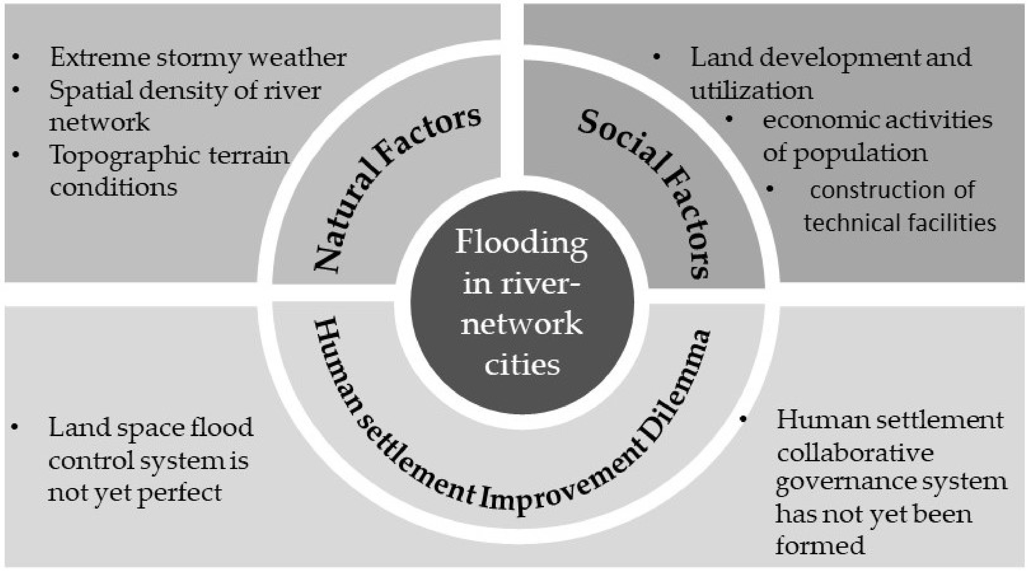
2.1. Flood Risk in River-Network Cities Driven by Natural and Social Factors

The natural flood risk factors include extreme rainstorm weather, river network density, and topographic conditions:
  • Frequent heavy rainfall causes severe water accumulation on the urban ground for a short period, resulting in a rise in the overall watershed water level.
  • River-network cities are often densely populated with river systems, and the water surface rate can reach more than 20–30%, so the density of the river network is significantly higher than that of ordinary cities, and the pressure to prevent flooding is even greater than that of ordinary cities.
  • The water system in river-network cities is complicated, the groundwater level is generally high, and the low and flat topographic conditions near the waters make lakes’ water capacity low, leading to poor drainage and increasing the risk of flooding.
The social factors of flood risk contain three aspects: land development and use, human social development, and construction of technical facilities:
  • Urban land development and utilization have encroached on the natural ecological function areas such as rivers and lakes, reducing the proportion of ecologically resilient land area in the city. Irrational land use leads to changes in the subsurface of the domain and an increase in impervious areas. Cities’ hazard-bearing and hazard-resilient capacities have been reduced, leading to secondary urban flooding risks [43,44].
  • On the one hand, human beings rely on excellent natural water resources for development and construction activities to obtain higher economic benefits. On the other hand, uncontrolled urban development and construction have also reduced the flood resilience of water ecosystems and increased the risk of human exposure to flooding.
  • Against the backdrop of high-intensity human construction activities, urban hard-surface areas have increased and the construction of underground drainage infrastructure has seriously lagged behind compared to its rapid development. The above situation causes profound surface water accumulation and poor underground drainage in river-network cities. Urban flooding is becoming increasingly severe [45,46].

2.2. The Dilemma of Human Settlement Improvement for River-Network Cities under Flood Resilience Regression Orientation

Currently, the dilemma of human settlement remediation in river-network cities under the guidance of flood resilience regression is reflected in two aspects: the flood control and regulation system of national space is not yet perfect, and the collaborative management mechanism is not yet sound.
  • The flood prevention and control system in the territorial space of river-network cities is not yet perfect. The means of urban flood management are still mainly based on engineering measures, including urban depressions, river ditches, and vegetation to store rain and floods. Flood management cannot reserve enough space for high-intensity flood risks based on the land-use structure and has not yet been considered the “production–living–ecological space” to form a graded control mechanism. In addition, river-network cities have not yet considered flooding environmental risks in the boundary delineation of urban growth boundaries, ecological protection redlines and basic farmland protection zones, which aggravate urban flooding risks.
  • The current resilience management of human settlements for river-network cities has not yet formed a collaborative response governance system that integrates urban resources and environmental conditions, scientific and technological innovation, social and public participation, policy planning guidance and other elements of human settlement management, and the roles of various stakeholders in flood risk management, authorization issues, and coordination among authorities are not clear.
Therefore, under the interaction of nature and manufacturing, the internal structure of the flood control system in river-network cities lacks stability, and the natural anti-disturbance ability is becoming weaker than before. Problems in one part of the flood risk management will lead to a series of chain reactions in the whole system and further increase the flood vulnerability, bringing dilemmas and challenges to the optimization of human settlements of river-network cities under the construction of flood resilient cities.

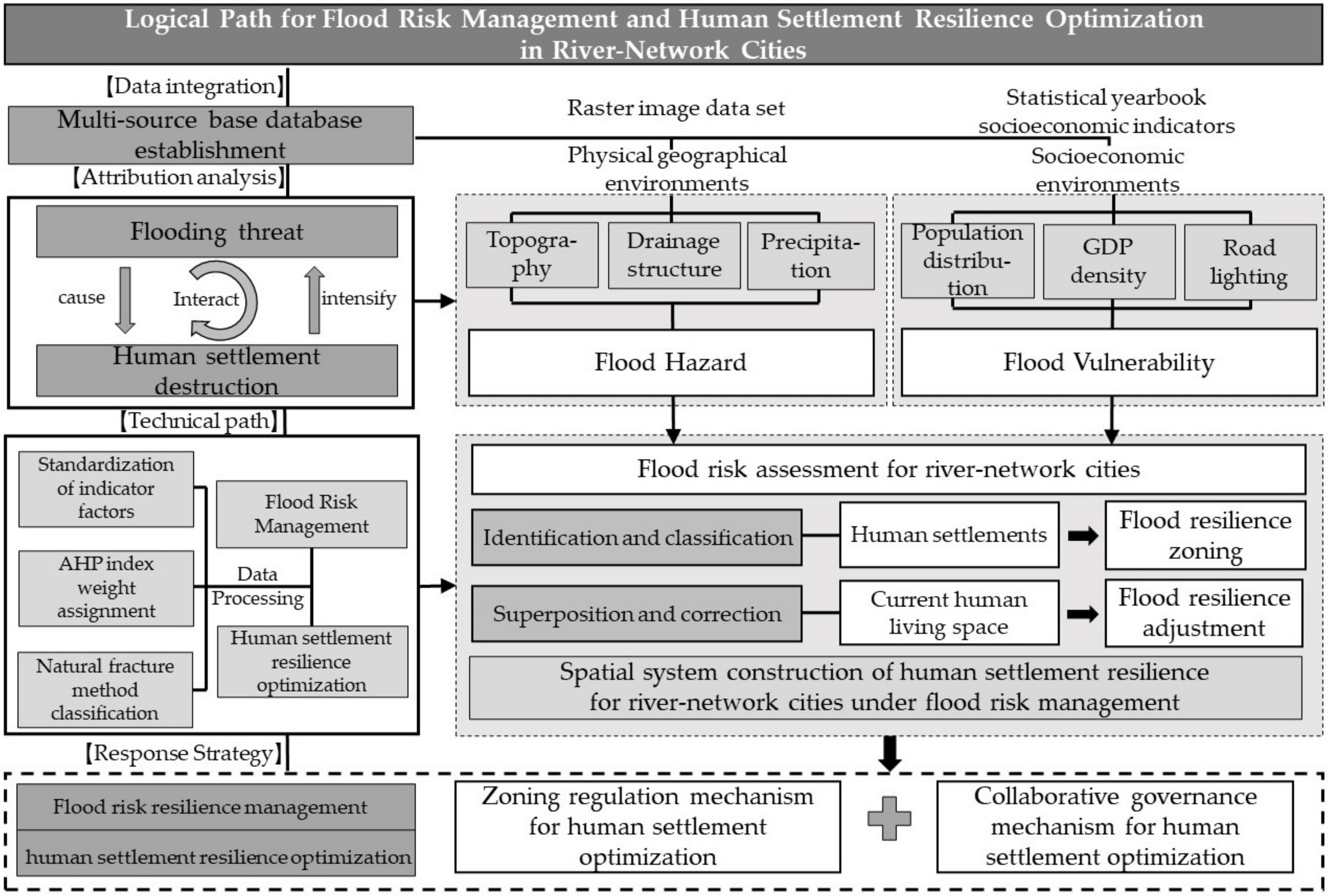
3. Logical Paths for Flood Risk Management and Human Settlement Resilience Optimization in River-Network Cities

3.1. Technical Path Design

Human settlement resilience zoning and optimizing strategies for river-network cities under flood risk management objectives can divide into the following four steps:
  • In this paper, we first analyze the causes of flood risk in river-network cities and the dilemma of improving human settlements to analyze the interactions between flood threat and human settlement destruction. Moreover, based on the domestic and foreign literature review, we collect the natural environment cover information and socio-economic development index data associated with urban flooding to build a primary database of river-network cities.
  • We standardize the selected two-dimensional flood risk element indicators, apply AHP hierarchical analysis to determine the weights, and construct a flood risk assessment model for river-network cities to provide technical prerequisites for constructing a resilient human settlement spatial system.
  • Thirdly, we carry out spatial zoning of city human settlement resilience levels based on flood risk assessment in river-network cities. On the other hand, we carry out flood prevention grading and adjustment of the current living space against territorial spatial planning.
  • Finally, we perform resilience management of flood risk and resilience optimization of human settlements in river-network cities from two levels of zoning regulation and collaborative management (Figure 3).

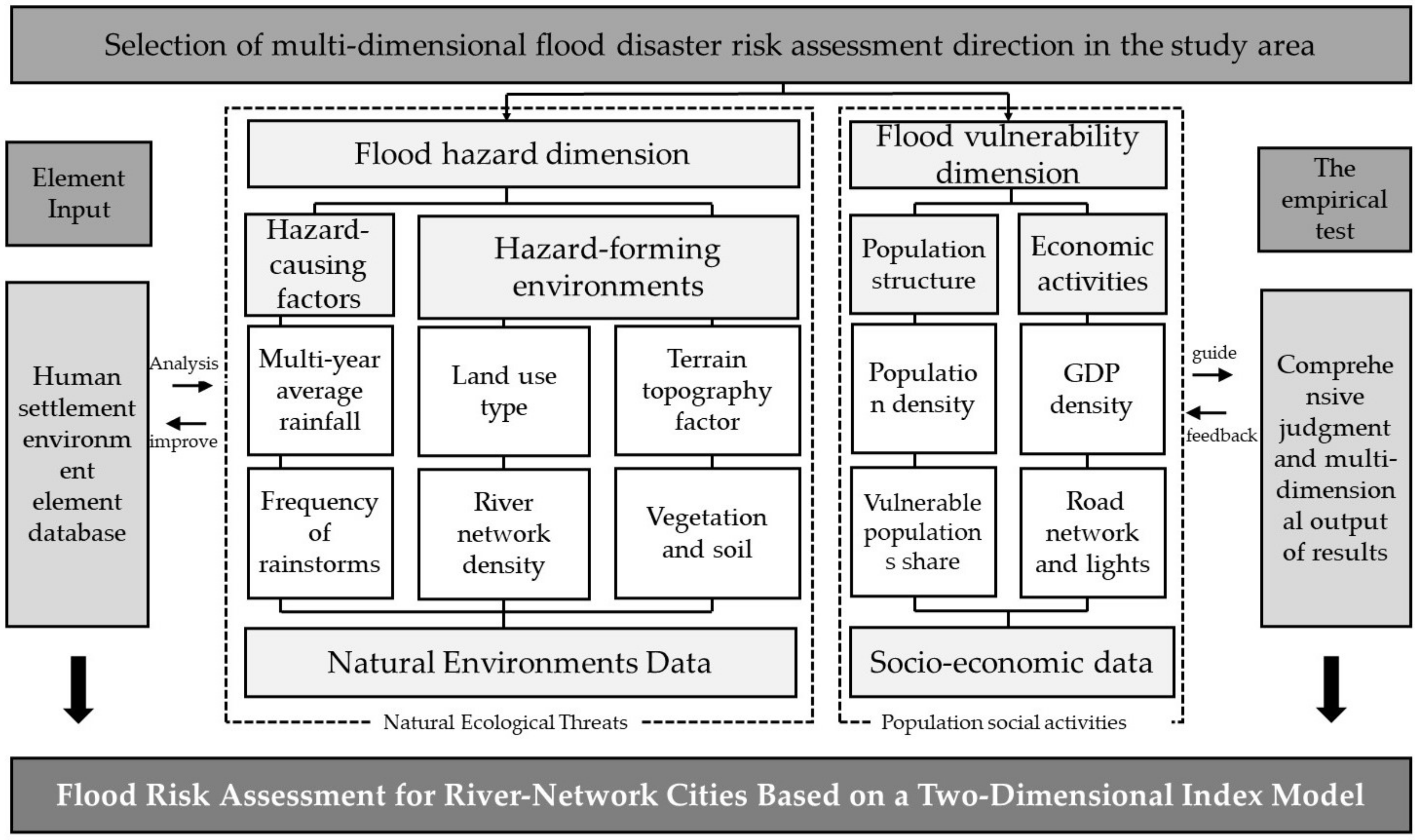
3.2. Construction of Flood Risk Assessment Model for River-Network Cities

Exploring the natural and social flood risk influencing factors of river-network cities can provide a data basis for improving urban flood resilience, make up for the lack of disaster prevention topics in traditional urban planning, and provide technical prerequisites for optimal response to human settlements. The flood risk assessment model for river-network cities is constructed mainly for the current situation of urban flood control and existing information, combining the opinions of designers and experts in urban planning-related disciplines [47,48,49]. Through the integration of opinions, this paper selects two significant directions of flood hazard and flood vulnerability. Among them, the hazard-causing factors and hazard-forming environments are mainly based on urban remote sensing image cover data. The vulnerabilities of population structure and economic activities are mainly based on socio-economic statistical yearbook data, forming a multi-source index database of human settlement elements to achieve the effect of comprehensive determination and multi-dimensional output of results (Figure 4).

3.2.1. Multi-Dimensional Element Index Selection

The hazard includes hazard-causing factors and hazard-forming environments. Precipitation is the primary hazard-causing factor for regional flooding. Two sub-indicators are selected as hazard indicators: multi-year average rainfall (H1) and frequency of rainstorms (H2). The rainstorm standard derives from the “Rainstorm Yearbook”. If one or more stations experience precipitation and the daily rainfall exceeds 50 mm, the rainstorm is judged to have started. The higher the average multi-year rainfall and the frequency of rainstorms, the higher the likelihood of flooding. Hazard-forming environments are essential places for forming hazard-causing factors and natural hazard generation, reflecting the formation mechanism of flooding, including the hydrological and underlying surface environments [50]. The more horizontal the topography is, the higher the water network environment is, and the greater the risk of flooding. In addition, the soil and water conservation capacity of vegetated soils can reduce the intensity of flood erosion to some extent. Therefore, land use type (H3), slope (H4), elevation (H5), river network density (H6), vegetation cover (H7), and soil conservation (H8) are selected to represent the risk indicators of the hazard-pregnant environment in this study.
Vulnerability, also known as fragility, refers to the inherent properties of hazard-bearing bodies to the loss suffered by the city. Hazard-bearing bodies represent the human social subjects directly affected and damaged by the disaster [51]. The region’s vulnerability tends to rise with the increase in population and property. At the population level, the higher the population density of a region, the higher the vulnerability to the flooding risk, in which the vulnerable groups less than 14 years old or more than 65 years old are generally more vulnerable to flooding stress. Therefore, this paper selects population density (V1), and vulnerable populations share (0–14 years old or >65 years old) (V2) as demographic vulnerability indicators. At the economic level, floods of the same magnitude have a higher density and value of hazard-bearing bodies in economically developed areas and cause more significant economic losses. GDP density indicates the value of GDP created per square kilometer of land, and the brightness of night lighting and the density of traffic road network also reflect the prosperity of the regional economy to some extent. Therefore, this paper selects the GDP density (V3), night lighting (V4), and road network density (V5) as indicators of economic activity vulnerability [52].

3.2.2. Standardization of Index Data Factors

Due to the complexity and variety of evaluation indicators, their meanings and dimensions are different, and the indicators are not comparable. In order to comprehensively calculate the data of each indicator, it is necessary to perform dimensionless standardization on the data. The value of each indicator is standardized to 0–1, and the standardized value can reflect the impact of the indicator on flood risk. Multi-year average rainfall, frequency of rainstorms, land-use type, slope, elevation, river network density, vegetation cover, soil conservation, population density, vulnerable populations share, GDP density, night lighting, and road network density are positive indicators. Elevation, slope, vegetation cover, and soil conservation are negative indicators. The standardized calculation formula is as follows.
For positive indicators,
Y i j = ( X i X m i n ) / X m a x X m i n
For negative indicators,
Y i j = ( X m a x X i ) / X m a x X m i n
where, Y i j is the ith value of the jth indicator; X i is the original value; X m a x and X m i n are the maximum and minimum values of the jth indicator.

3.2.3. Weight Assignment and Comprehensive Evaluation

The premise of the comprehensive evaluation of flood riskiness level is to assign values to each dimensional indicator according to its importance in turn, and the weight of each indicator reflects its degree of influence on flood risk. Hierarchical analysis (AHP) is a combined qualitative and quantitative weighting analysis and decision-making method proposed by Saaty [53]. Its main idea is to split the final goal into individual factor indicators and compose the indicators into different levels of the hierarchical structure according to the hierarchical relationship. Finally, by scoring the crucial indicators with weights and constructing a weight judgment matrix, the target results are derived from the bottom up.
The flood risk assessment model of river-network cities is mainly used to rank the importance of each index in order to determine the evaluation weights using a questionnaire. A total of 25 questionnaires were distributed to people from different fields related to flood risk management and city human settlement construction, including designers, experts, and teachers with specific qualifications in resilient urban planning, to ensure the authenticity of the data results and the wide range of data sources. Finally, the consistency test of the weight matrix of each index met CR < 0.1, indicating the authenticity and reliability of the data. The standardized calculation formula is as follows.
R = i = 1 n C i W i
where, R denotes the ecological safety index or its unidimensional safety index, respectively; i denotes the number of indicators involved; Ci denotes the indicator evaluation results; and W i denotes the indicator weights (Table 1).
After determining the factor weights of each index, this paper uses the raster calculator to obtain the weighted values of flood risk for river-network cities with the help of ArcGIS software and calculates the comprehensive flood risk index on each spatial raster cell. Then, we use the natural breakpoint method to classify the comprehensive flood risk evaluation index into five levels: highest, high, medium, low, and lowest. Finally, a risk level map with a resolution of 1 km is formed to visualize and comprehensively evaluate flood risk in the geographical area.

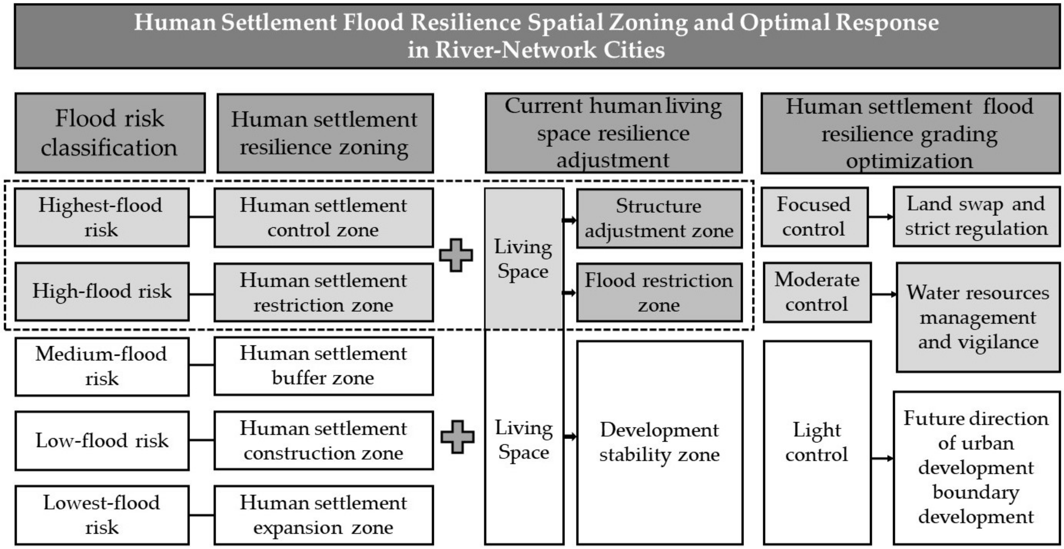
3.3. Spatial Zoning and Optimal Response for Human Settlement Flood Resilience in River Network Cities

In the context of flood risk management, spatial zoning of flood resilience levels of human settlements based on the assessment level of flood risk in river-network cities can ensure the orderly implementation of urban flood prevention and provide a theoretical basis and decision support for the site selection of human settlement construction [54]. Further, the spatial overlay analysis function in ArcGIS software can align the highest-risk and high-risk areas with the living space in the existing territorial spatial planning functional zoning. The classification of flood prevention levels and structural adjustment of living space are conducive to zoning linkage regulation of human development activities and strengthen the resilience optimization of river-network cities to cope with flood risks [55]. Structure adjustment zone for living space can provide a basis for vacating and replacing conflicting land types in the territorial space. Flood restriction zone for living space can provide the basis for local adjustment and buffer of land use structure by integrating water resource elements. Development stability zone can provide a basis for the urban growth boundary delineation of river-network cities and guide future population flow and human activities (Figure 5).

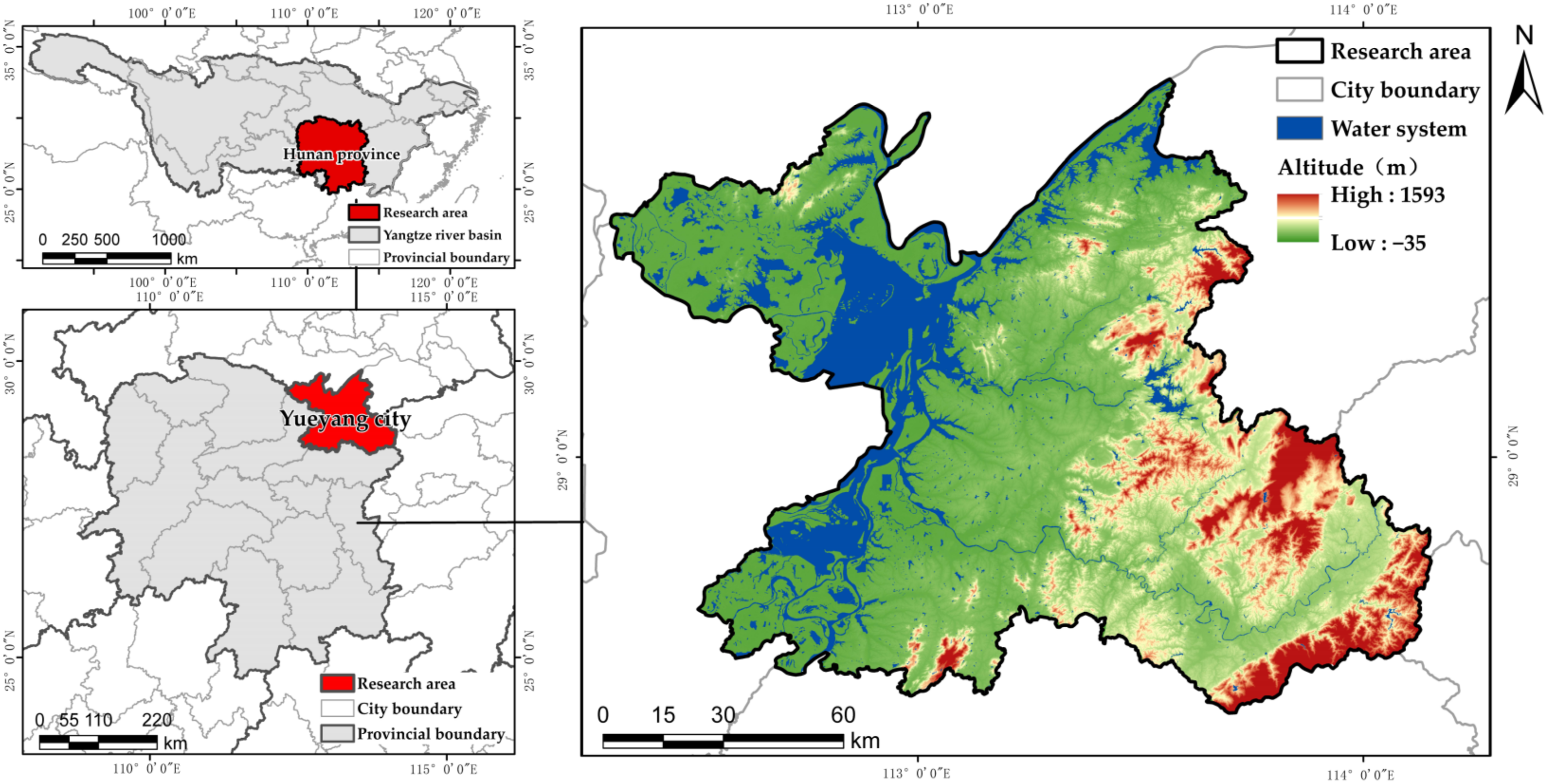
4. Empirical Research: Taking Yueyang City, a Typical City with Abundant River Network in the Yangtze River Basin, as an Example

4.1. Overview of the Study Area

Yueyang city is located in the northeastern part of Hunan Province, on the south bank of the middle reaches of the Yangtze River, with a total land area of 0.09 km2. It is a typical representative of river-network cities in the vast southern region. The topography of Yueyang city is high in the east and low in the west, with a stepped slope toward Dongting Lake. The landform type is mainly hills and plains, and it belongs to the subtropical monsoonal humid climate zone with humid climate and abundant rainfall (Figure 6).
In recent years, Yueyang city has experienced rapid economic and social development under the influence of high-intensity human construction activities. The growing population and highly prosperous economic system have determined its exposure to high flooding risks and the importance of natural hazard warnings. Statistics show that Yueyang city is an area prone to summer storm flooding. With the increasing frequency of extreme rainfall hazards, Yueyang city suffers severe losses from storm flooding every year, which significantly restricts human production, living activities and ecological protection. With the unsound drainage facilities, Yueyang city has become the hardest-hit area by flooding in Hunan Province. Taking Yueyang city as an example, this paper conducts flood risk evaluation, delineates the suitable space for flood resilience of human settlements, and proposes optimized response measures, intending to serve as a reference for river-network cities with similar environmental conditions concerning river and lake units.

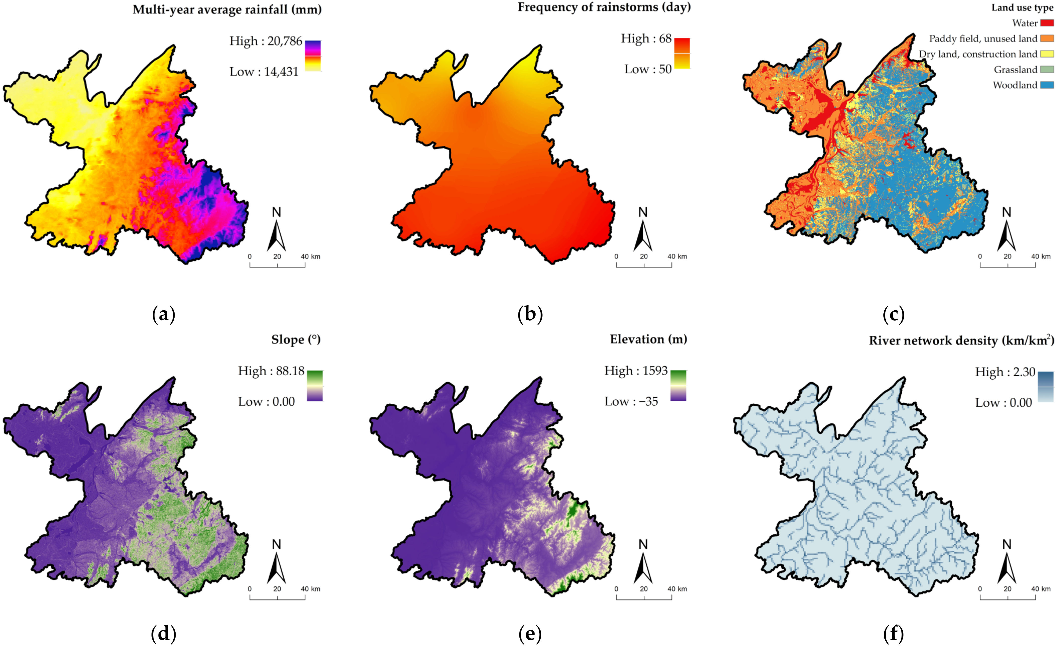
4.2. Data Source and Processing

This study’s raw data mainly includes meteorological data, natural environment element data and socio-economic data. Among them, the extraction of vegetation cover is mainly achieved by using remote-sensing images of Yueyang TM with Bandmath function on ENVI5.3 software (Broomfield, CO, USA); the extraction of elevation and slope is calculated based on DEM under Surface and Neighborhood tools on ArcGIS10.5 software (Redlands, CA, USA), respectively (Table 2).

4.3. Risk Assessment of Flooding in Yueyang City

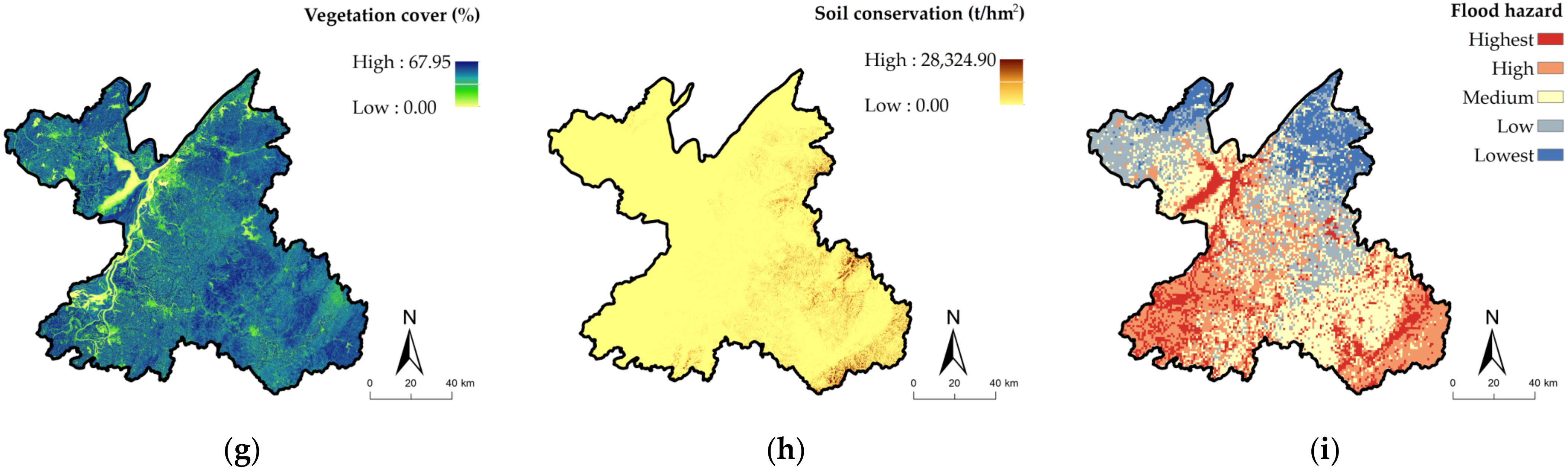
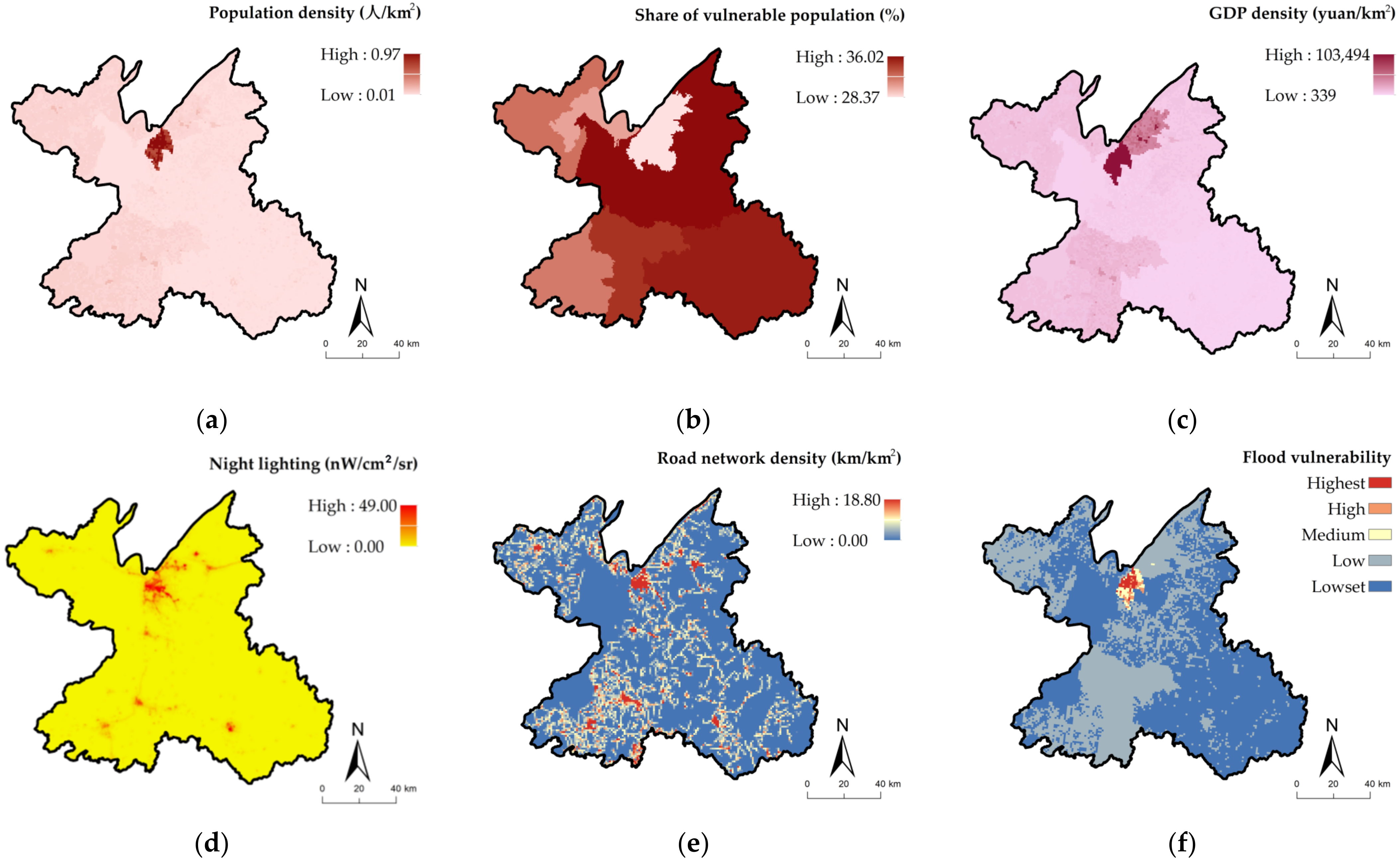
4.3.1. Hazard Assessment of Flooding in Yueyang City

Flood hazard is one of the factors reflecting the degree of flooding, and the flood hazard within each raster area can be calculated according to the index weights. The flood hazard evaluation results are divided into five risk levels: highest risk, high risk, medium risk, low risk, and lowest risk (Figure 7). At the level of hazard-causing factors, the multi-year average rainfall and frequency of rainstorms in Yueyang city show a gradually decreasing distribution trend from southeast to northwest. At the level of land-use types, water spaces such as rivers, canals, lakes, reservoirs, and ponds in the northwestern part of Yueyang city are subject to a high degree of natural erosion by floods, accounting for 43.23% of the total land area of Yueyang city. Regarding geological hazards, the areas with higher slopes and elevation are mainly the Lianyun Mountain area in the east of Yueyang city, the south area of Tieling Reservoir and the Mufu Mountain area, where the risk of flooding is high. A relatively uniform distribution of the density of the river network in Yueyang city, flowing from the southeastern hills to the main body of Dongting Lake Basin. The overall level of vegetation cover in Yueyang city is high, mainly in Pingjiang country and Linxiang city in the southeastern part of Yueyang city. At the soil conservation level, the overall soil conservation in Yueyang city is low, and the degree of soil conservation is higher in the woodland areas in the southeast.
In general, the highest hazard area is mainly in the central area of the Dongting Lake waters and its interconnected water system, local areas in the southwest and the southeastern edge. This type of space is mainly the core protection area of essential wetlands, water systems, and nature reserves in Yueyang city, with relatively low and flat terrain, high river network density and soil erodibility, and a low level of flood-protection resilience. The lowest-risk area is mainly located in the northern forest area of Yueyang city, with low rainfall and exemplary soil conservation.

4.3.2. Vulnerability Assessment of Flooding in Yueyang City

The vulnerability index of Yueyang city mainly reflects the risk response ability of social and economic factors to flooding. Similarly, the flood vulnerability in each grid area can be calculated according to the index weight. The flood vulnerability evaluation results have five risk levels: highest risk, high risk, medium risk, low risk, and lowest risk (Figure 8). The distribution among the four indicators of population density, average GDP, road network density, and nighttime lighting in Yueyang city has strong spatial synergy in geographical areas, with the highest value in Yueyanglou district and Yunxi district, which are near the Dongting Lake water body. These areas are the urban centre of Yueyang city and are more vulnerable to flood risk. The area with a higher proportion of vulnerable populations is Yueyang county, with a more significant proportion of youth and older people and a higher response capacity to flood. The response capacity to flood risk is relatively low.
Overall, the highest vulnerability area to flooding in Yueyang city is located in the Yueyanglou district in the north of Yueyang city, which is rapidly developing based on the excellent water ecological environment, with high populations, GDP density, and developed economic conditions. The lowest vulnerability area is east of Yueyang city, mainly covered by woodland ecological resources, with sparse populations and slow economic development.

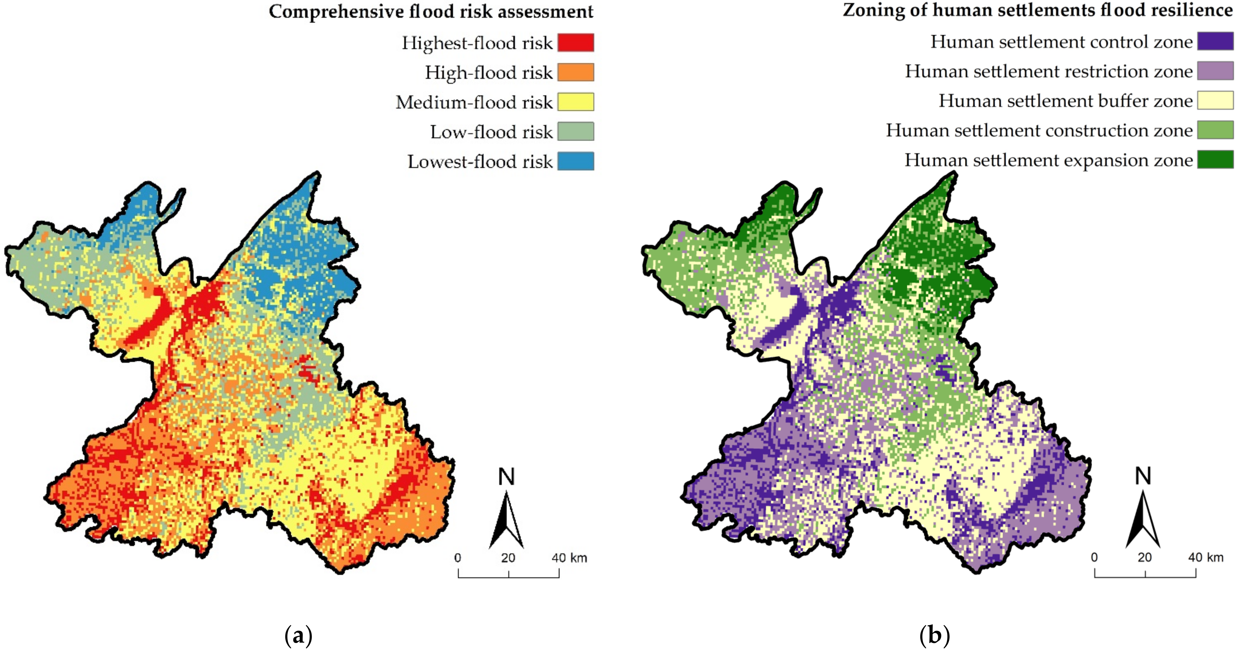
4.3.3. Comprehensive Assessment of Flood Risk in Yueyang City

The risk evaluation results of the study area’s single dimension of flood hazard and flood vulnerability are obtained through the weighted superposition evaluation of each dimensional index. The structure is used as the integrated evaluation index of flood risk in the study area, and the final spatial distribution of the integrated flood risk assessment level in Yueyang city is obtained (Figure 9a).
The highest-risk and high-risk areas in Yueyang city are mainly located in the central Dongting Lake and its interconnected water system, the local area in the southwest, and the southeastern fringe, covering 38.97% of the total area of Yueyang. The above areas have relatively abundant precipitation, a dense river-network water system, flat terrain, and low vegetation coverage. The types of land are mainly mountainous, hilly areas, swampy wetlands, lakes, and rivers, which are mostly valley catchment areas and natural ecological resource protection areas in Yueyang city. The medium-risk area is mainly located around the high-risk area, and the land type includes economic forest land and the land part of Dongting Lake, which plays a specific role in buffering and regulating flooding. The low-risk and lowest-risk areas are mainly located in the local northeastern area and the northwestern edge, with agricultural land and forest land as the mainland types. These areas have low precipitation, insignificant population and economic activities, which have a low risk of flooding stress.

4.4. Spatial Construction of Human Settlement Resilience System in Yueyang City Based on Flood Risk Assessment

4.4.1. Identification of Human Settlement Flood Resilience Zoning of Yueyang City

Based on the above flood risk level, the spatial zoning of Yueyang city’s human settlement resilience level under the flood risk management objective is divided into five categories from low to high: human settlement control zone, human settlement restriction zone, human settlement buffer zone, human settlement construction zone, and human settlement expansion zone, which correspond to Yueyang city’s flood highest-risk area, high-risk area, medium-risk area, low-risk area, and lowest-risk area, respectively (Figure 9b).
Among them, the total area of the human settlement control zone is 1837.96 km2, accounting for 12.39% of the city’s total area. This region is at the highest risk of flooding and has low human settlement resilience, making it highly unsuitable for human habitation. The total area of the human settlement restriction zone is 3942.64 km2, accounting for 26.58%, and the level of resilience repair after flood erosion in this area is also low. Strict flood control measures are needed in the area to ensure the safety of human production and life. The buffer zone of human settlements is 4538.01 km2, accounting for 30.60%. As a transition area between the high and low risk of flooding, it is critical for the suitability of human settlements in Yueyang city and an alternative resilient area for human development and construction activities. The construction zone of human settlements is 3051.06 km2, accounting for 20.57%, and the expansion zone of human settlements is 1461.42 km2, accounting for 9.85%. These zones have a low risk of flood erosion and a high resilience level of human settlements, which are the best areas for future human activities and urban development and construction in Yueyang city.

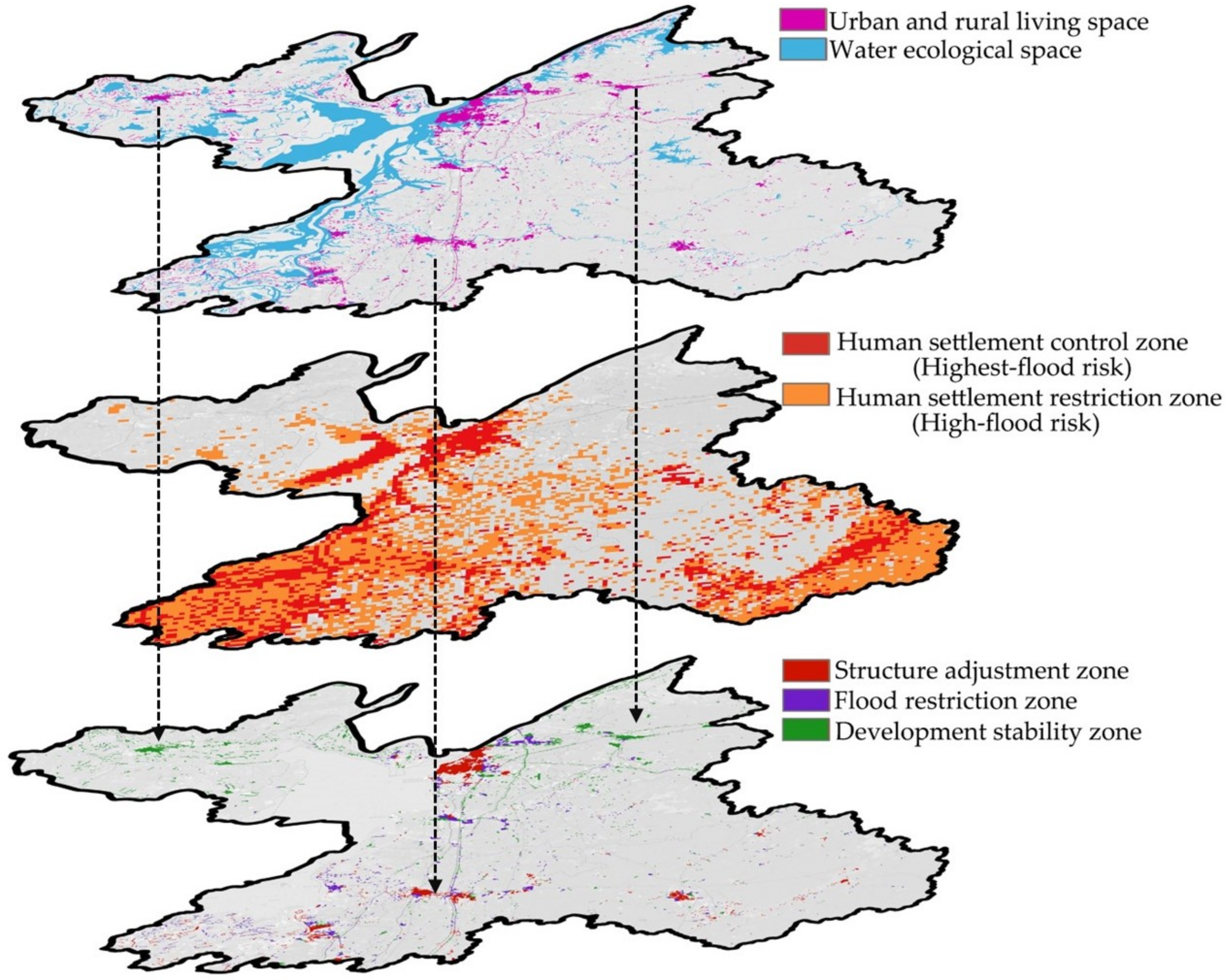
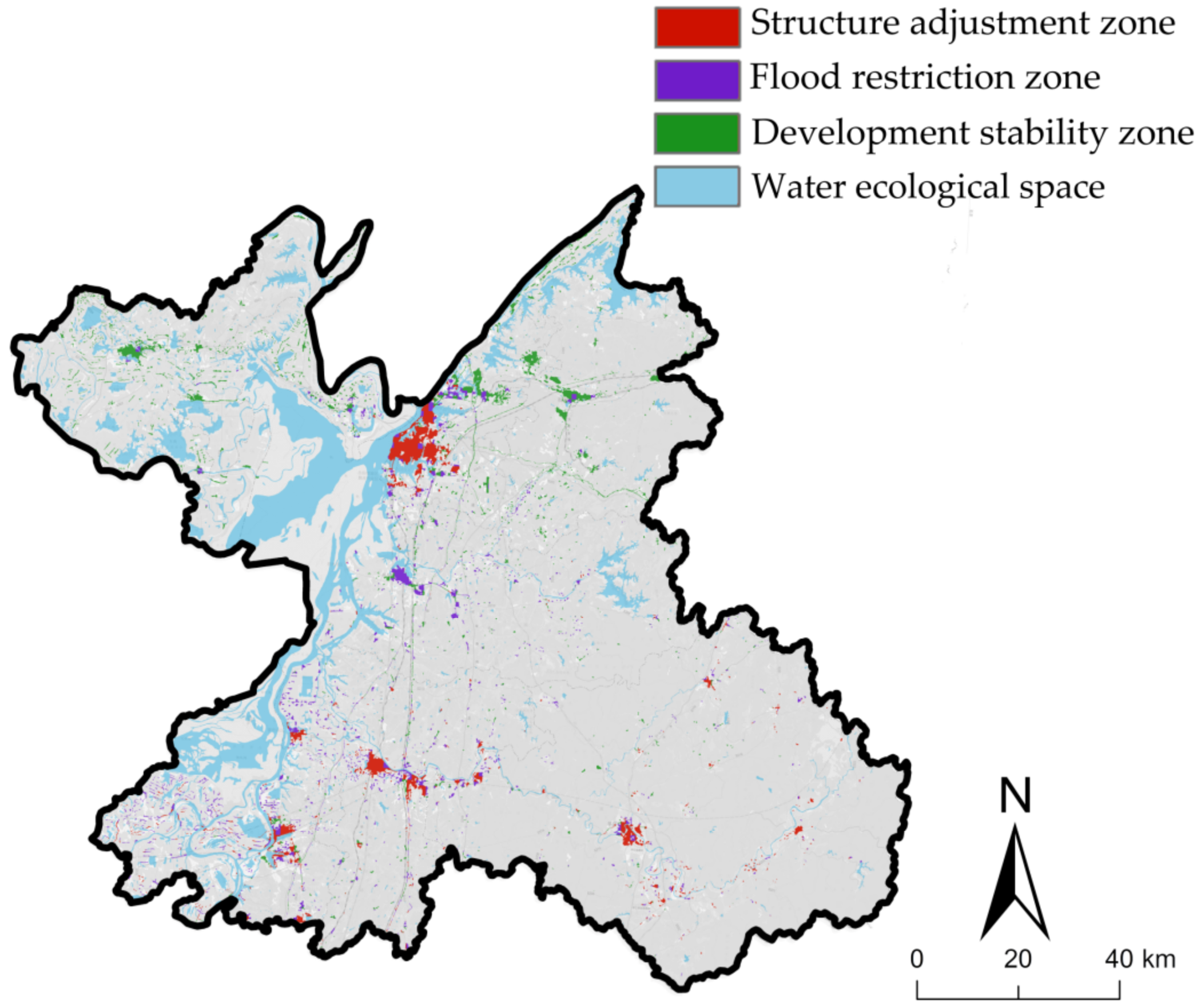
4.4.2. Grading Adjustment of Living Space Flood Resilience in Yueyang City

In order to further develop the spatial response of human settlements under the flood risk management objectives in Yueyang city, this study extracts the urban–rural, industrial-mining, and residential land in the land-use structure as the territorial living space by comparing the “production–living–ecological” functional zoning and urban–rural construction planning from the perspective of planning preparation. Then the spatial overlay is carried out with the control and restriction zones, and the flood prevention level of the current living space is classified to guide the revision and adjustment of the territorial spatial planning in Yueyang city. After outputting, the flood prevention level of living space contains three categories: structural adjustment zone, flood restriction zone, and development stability zone (Figure 10).
Among them, the structural adjustment zone is the overlapping part of the highest flood risk area and the living space of human settlements. This area is mainly distributed near the central waters of Dongting Lake in the north and southwest of Yueyang city, accounting for 33.79% of the current living space of human settlements. The flood restriction zone is the overlapping area of urban and rural living space in the high flood risk area, with a fragmented distribution, accounting for 26.35% of the urban and rural living space. The development stability zone is the urban and rural living space with a low risk of flooding, accounting for 39.86%, which is less risk of flooding and safer for human development and construction activities. The results indicate that human production and living construction highly depend on the watershed’s ecological resources. While benefiting from the advantages of the watershed resources for development and construction, the human living space also faces a high flood risk threat simultaneously (Figure 11).

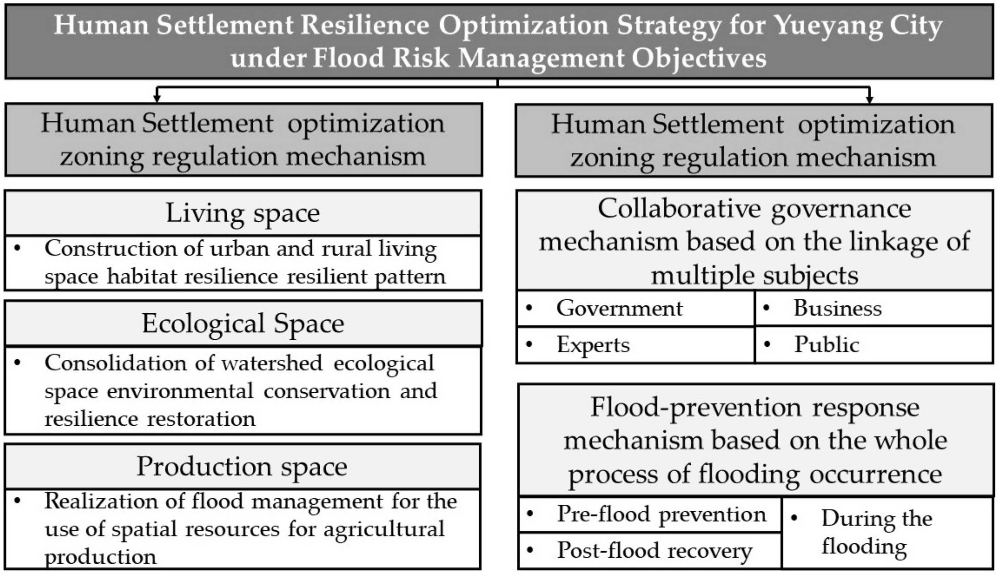
4.5. Human Settlement Resilience Optimization Strategies for Yueyang City under Flood Risk Management Objectives

From the perspective of flood risk management in river-network cities, constructing an optimal response mechanism for human settlement resilience can help promote the coordinated development between natural hazards and human survival and development. As a complex system project, optimizing human settlement resilience should eliminate the vague and sloppy planning and management mode to highlight the role of planning control and spatial governance in “ensuring the bottom line, setting rules and leaving flexibility”. It requires the superimposition of diversified control frameworks, governance requirements and construction guidance within the scope of spatial units at different levels to achieve refined flood risk management and improvement of the resilience level of human settlements in Yueyang city with territory-wide coverage. This paper proposes the optimization strategies of human settlements from the perspective of flood risk management at two levels: zoning control and collaborative management (Figure 12).

4.5.1. Zoning Regulation Mechanism for Human Settlement Optimization in Yueyang City

At the level of refined zoning control for human settlement optimization in Yueyang city, human settlement spatial control, as the primary implementation unit of territorial spatial planning and governance, involves multiple spatial systems and covers a wide range of contents. This section proposes the zoning control strategy for human settlement optimization based on the differentiation level of land nature of urban and rural living space, blue–green ecological space and agricultural production space in Yueyang city.
Urban and rural living space: building a human settlement resilience pattern for the urban and rural living space. According to the classification of flood prevention and resilience of living space in Yueyang city, we focus on the layout of living land in the planning area of urban growth boundaries and implement the measures of flexibility-based, rigid–flexibility combined, and rigid-based for development stability zone, flood restriction zone, and structural adjustment zone, respectively.
  • In the structural adjustment zone, the land-use development should consider the hazard-bearing capacity of the ground, strictly control the human development and construction in the flood risk zone, and strengthen the layout planning of green infrastructure and emergency rescue base points in urban construction space. It should ensure timely flood storage and drainage when heavy rain and floods come, and improve the resilience of Yueyang city to cope with floods. In addition, for high-risk areas unsuitable for human settlement construction, the quality of human settlements can be optimized through partial land-use debugging, replacing land with ecological parking lots and green squares to reduce flood risks and optimize urban and rural construction space.
  • For the flood restriction zone, the socio-economic and cultural elements can be introduced into the available water management policies of watersheds and riverbanks to ensure that the water elements are fully considered and utilized in the construction of towns and cities and to maintain the “living with water” human settlement resilience planning.
  • The development stability zone has high resilience in flood control. It can be used to delineate future urban growth boundaries and development direction in Yueyang city to focus on development and construction and guide future population flow and human development activities.
Watershed ecological space: consolidating environmental conservation and resilient restoration of watershed ecological space. The ecological space of Yueyang city should strictly implement water ecological safety control, strictly adhere to the ecological protection red line of Dongting Lake, and firmly build a blue–green barrier.
  • Implement all-around protection for the core ecological space such as Dongting Lake Ecological Protection Zone and important mudflat wetlands with a high risk of flooding, and prohibit all human productive business activities from achieving the dual effect of protecting the environment of the water and enhancing the resilience of the human living environment. The effect is to protect the watershed’s ecological environment and enhance the human settlements’ resilience.
  • In addition, for national forest parks and various economic forest resources, natural restoration should be strengthened, and artificial restoration means such as forest cultivation should be introduced to enhance their soil and water conservation and nourishment functions and reduce the risk of flooding in Yueyang city.
Agricultural production space: realizing resource utilization and flood management of agricultural production space.
  • The agricultural production space in Yueyang city should implement the policy of returning farmland to forests and lakes, implement compensation for farmland, plant trees according to local conditions, restore forest vegetation, and enhance flood resilience.
  • Secondly, it should enhance flood risk prevention in the agricultural space with a high risk of flooding and high sensitivity, improve the construction of agricultural water conservancy infrastructures, such as reservoirs and ponds, and improve the ability to regulate and control water resources.
  • Thirdly, it should reasonably arrange the drainage and dredging facilities in agricultural land, and do an excellent job of dredging flooding rivers to avoid the phenomenon of river breaching, to reduce the economic losses under extreme heavy rainfall and flooding in agricultural production space.

4.5.2. Collaborative Governance Mechanism for Human Settlement Optimization in Yueyang City

At the level of collaborative governance for human settlement optimization in Yueyang city, this paper mainly considers two classes of synergy in decision making between stakeholders at all levels and synergy in governance during the whole process of natural hazard occurrence to effectively strengthen the awareness of flood resilience optimization of human settlements from the region, city, and community to the individual public.
Collaborative governance mechanism based on the linkage of multiple subjects. By constructing the implementation mechanisms such as governance synergy between the government and various subjects of the department, the unique synergy between various elements of resources and environment, and linkage synergy between various players of interest, we strengthen the cooperation and resource sharing with the departments associated with flood risk management and carry out the graded protection linkage between the territorial space control units of the country.
  • Firstly, Yueyang city needs to form a stakeholder role system by combining government agencies in meteorology, hydrology and transportation, business organizations in pollution, management and supervision of the Dongting Lake Basin, experts and scholars in water resources, meteorology and disasters, and the interests of the public.
  • Then, the core concerns of various stakeholders, such as watershed enterprises, government departments, insurance companies, and public residents, are comprehensively considered so that spatial interests in the domain are balanced and negotiated.
  • Finally, based on the identification and estimation of flood risks, each stakeholder makes a more desirable pro-disaster dispatch decision, which can further improve the resilience level of Yueyang city in response to flood emergencies.
The flood-prevention response mechanism based on the whole process of flooding occurrence. Combined with intelligent city planning and construction, the feedback mechanism of flood control based on the whole process of flooding participation covers the closed loop of top-down participation from regions and towns to communities, aiming to optimize the response of the human living environment from three levels before, during, and after flooding.
  • Through the flood risk atlas, we can collect monitoring and early warning information of urban flood-prone and waterlogged points and strengthen pre-flood online warning and preparation of flood plans. Strengthen natural hazard education and training by community units, guide the whole society to participate in flooding prevention, and improve individual residents’ awareness and self-help ability in dealing with flood risks in the future.
  • Strengthen the emergency response mechanism in flooding with joint civil–military and regional linkage, and set up professional and social emergency rescue teams to ensure comprehensive control, real-time monitoring, and emergency dispatch of flood-control materials.
  • The post-flood linkage public transportation system strengthens the response to evacuation under flooding and builds a medical infrastructure design evacuation system for post-flood recovery under flooding risk to cope with the duress of future floods coming again.

5. Conclusions and Discussion

5.1. Conclusions

This paper selects Yueyang city as a typical river-network city in the Yangtze River Basin for research. The flood risk level of Yueyang city is assessed based on the multivariate data of natural and social elements of human activities. The results are fed back to the construction of urban human settlement optimization and improvement system, and the flood resilience zoning and optimization responses of the human settlement of the river-network city under the flood risk management objectives are conducted. Specifically, the following conclusions are drawn.
  • Based on the assessment of flood risk at the hazard and vulnerability levels, Yueyang city is divided into five levels: highest-risk area, high-risk area, medium-risk area, lower-risk area, and lowest-risk area. The highest-risk and high-risk areas are mainly located in the central Dongting Lake and its interconnected water system, the local area in the southwest, and the southeastern fringe. The medium-risk area mainly contains economic forests and the land part of Dongting Lake shoreline. The low-risk and lowest-risk areas are mainly located in the northeast local area and northwest edge, with a low risk of flood stress.
  • According to the urban flood risk level, the human settlement flood resilience spatial zoning in Yueyang city ranges from low to high: human settlement control zone, human settlement restriction zone, human settlement buffer zone, human settlement construction zone, and human settlement expansion zone. The total area of the human settlement control zone is 1837.96 km2, accounting for 12.39% of the city’s total area. The spatial area of the restriction zone is 3942.64 km2, accounting for 26.58%. The buffer zone is 4538.01 km2, accounting for 30.60%. The construction zone is 3051.06 km2, accounting for 20.57%. The expansion zone is 1461.42 km2, accounting for 9.85%.
  • Further, by comparing overall territorial space planning, Yueyang city’s human settlement control zone, human settlement restriction zone, and territorial living space overlap and are analyzed, and the current living space of Yueyang city is graded and adjusted for flood control. After the output, the flood resilience zoning of the current living space in Yueyang city contains three categories: structure adjustment zone, flood restriction zone, and development stability zone. They account for 33.79%, 26.35%, and 39.86%, respectively, indicating that human production and living construction activities have a high environmental dependence on the ecological resources of the water, and the living space of the human settlements, while benefiting from the advantages of water resources for development and construction, also facing a high flood risk coercion at the same time.
  • The specific control and implementation of Yueyang city’s human settlements mainly focus on the interrelationship between the flood risk area of the watershed, the development pattern of human activities, and the optimized response to the city’s human settlements. The content contains the following two levels: one is the zoning regulation mechanism for human settlement optimization based on the land function of “production–living–ecological space” and the flooding resilience of construction space, and the other is the cooperative management mechanism of human settlement optimization based on multi-stakeholder and the whole process of flooding.

5.2. Discussion

In order to further promote the synergistic improvement of human settlement optimization in the national space of river-network cities, this paper argues that the following research work needs to be guided by “the interactions between humans and their environments” and improved in the following three aspects.
  • Currently, the contradiction between natural ecological environments and population urbanization is becoming more intense. At the same time, the emerging urban planning technologies, such as big data, cloud computing, artificial intelligence, and mobile Internet, are constantly updated while putting forward new requirements for flood risk management in river-network cities. Therefore, at the level of technological innovation, the future river-network cities should take urban public safety technology as the core, and through interdisciplinary technology-driven construction of a platform of comprehensive flood risk factors of intelligent information management, to achieve the efficient and intelligent development of the human settlement resilience management of river-network cities.
  • The construction of resilient cities under the threat of natural hazard risk has been elevated to a national strategy. In territorial spatial planning, the concept of resilience should be integrated into natural hazard risk management and human settlement optimization. Therefore, from the planning level, comprehensive disaster prevention and mitigation planning should be incorporated into the special planning of the territorial spatial planning system, forming a comprehensive planning system that is closely connected and synchronized with the territorial spatial overall planning. At the same time, the “fine control” should be implemented into the spatial “one map” planning system through the development of graded classification and zoning of flood risk control tools.
  • Optimizing the resilience of river-network cities requires the simultaneous follow-up of various stakeholders with the “watershed” as the governance unit. At present, human settlement construction in watersheds under flood risk management often spans multiple administrative divisions and involves multiple stakeholders. Therefore, updating the management criteria, policies, and regulations in different administrative units is challenging. At the level of implementation feedback, the path of resilient development of human settlements based on “collaborative governance” needs to consider the leap from city scale to watershed scale and realize the collaborative governance of multiple stakeholders. In addition, the relevant legal and policy frameworks should be further improved to provide practical constraints for optimizing human settlements in the future territorial space.

Author Contributions

All authors contribute to the development of the proposed methodology and/or its application. Conceptualization, F.Y., S.X.; software, S.X.; validation, F.Y.; data curation, S.X.; writing—original draft preparation, F.Y., S.X.; writing—review and editing, F.Y., S.X.; supervision, F.Y.; project administration, F.Y.; funding acquisition, F.Y. All authors have read and agreed to the published version of the manuscript.

Funding

National Nature Science Foundation of China (Grant No. 51608535, 72174211); Nature Science Foundation of Hunan Province (Grant No. 2018JJ3667); Philosophy and Social Science Project Foundation of Hunan Province (Grant No. 19YBA347); Postgraduate Teaching Reform Project of Central South University (Grant No. 2020JGB139).

Institutional Review Board Statement

Not applicable.

Informed Consent Statement

Not applicable.

Data Availability Statement

The data presented in this study are available on request from the corresponding author.

Conflicts of Interest

The authors declare no conflict of interest.

References

  1. Du, W.W.; FitzGerald, G.J.; Clark, M.; Hou, X.Y. Health Impacts of Floods. Prehosp. Disaster Med. 2010, 25, 265–272. [Google Scholar] [CrossRef] [PubMed]
  2. Morita, M. Quantification of increased flood risk due to global climate change for urban river management planning. Water Sci. Technol. 2011, 63, 2967–2974. [Google Scholar] [CrossRef] [PubMed]
  3. Vinten, A.; Kuhfuss, L.; Shortall, O.; Stockan, J.; Ibiyemi, A.; Pohle, I.; Gabriel, M.; Gunn, I.; May, L. Water for all: Towards an integrated approach to wetland conservation and flood risk reduction in a lowland catchment in Scotland. J. Environ. Manag. 2019, 246, 881–896. [Google Scholar] [CrossRef] [PubMed]
  4. Casper, M.C.; Herbst, M.; Grundmann, J.; Buchholz, O.; Bliefernicht, J. Influence of rainfall variability on the simulation of extreme runoff in small catchments. Hydrol. Wasserbewirtsch. 2009, 53, 134–139. [Google Scholar]
  5. Sanyal, J.; Lu, X.X. Remote sensing and GIS-based flood vulnerability assessment of human settlements: A case study of Gangetic West Bengal, India. Hydrol. Process. Int. J. 2005, 19, 3699–3716. [Google Scholar] [CrossRef]
  6. Miguez, M.G.; Verol, A.P.; de Sousa, M.M.; Rezende, O.M. Urban Floods in Lowlands—Levee Systems, Unplanned Urban Growth and River Restoration Alternative: A Case Study in Brazil. Sustainability 2015, 7, 11068–11097. [Google Scholar] [CrossRef] [Green Version]
  7. Lyu, H.M.; Sun, W.J.; Shen, S.L.; Arulrajah, A. Flood risk assessment in metro systems of mega-cities using a GIS-based modeling approach. Sci. Total Environ. 2018, 626, 1012–1025. [Google Scholar] [CrossRef]
  8. Barnes, A.; Nel, V. Putting Spatial Resilience into Practice. In Urban Forum; Springer: Amsterdam, The Netherlands, 2017. [Google Scholar]
  9. Holling, C.S. Resilience and Stability of Ecological Systems. Annu. Rev. Ecol. Syst. 1973, 4, 1–23. [Google Scholar] [CrossRef] [Green Version]
  10. Bulti, D.T.; Girma, B.; Megento, T.L. Community flood resilience assessment frameworks: A review. SN Appl. Sci. 2019, 1, 1663. [Google Scholar] [CrossRef] [Green Version]
  11. Motesharrei, S.; Rivas, J.; Kalnay, E.; Asrar, G.R.; Busalacchi, A.J.; Cahalan, R.F.; Cane, M.A.; Colwell, R.R.; Feng, K.S.; Franklin, R.S.; et al. Modeling sustainability: Population, inequality, consumption, and bidirectional coupling of the Earth and Human Systems. Natl. Sci. Rev. 2016, 3, 470–494. [Google Scholar] [CrossRef] [Green Version]
  12. Folke, C. Resilience: The emergence of a perspective for social-ecological systems analyses. Glob. Environ. Chang. Hum. Policy Dimens. 2006, 16, 253–267. [Google Scholar] [CrossRef]
  13. Nelson, D.R.; Adger, W.N.; Brown, K. Adaptation to environmental change: Contributions of a resilience framework. Annu. Rev. Environ. Resour. 2007, 32, 395–419. [Google Scholar] [CrossRef] [Green Version]
  14. Yang, W.P.; Zhao, J.K.; Zhao, K. Analysis of Regional Difference and Spatial Influencing Factors of Human Settlement Ecological Environment in China. Sustainability 2018, 10, 1520. [Google Scholar] [CrossRef] [Green Version]
  15. Meerow, S.; Newell, J.P.; Stults, M. Defining urban resilience: A review. Landsc. Urban Plan. 2016, 147, 38–49. [Google Scholar] [CrossRef]
  16. Black, A.R.; Burns, J.C. Re-assessing the flood risk in Scotland. Sci. Total Environ. 2002, 294, 169–184. [Google Scholar] [CrossRef]
  17. Cioffi, F.; Trapella, A.D.; Giannini, M.; Lall, U. A Flood Risk Management Model to Identify Optimal Defence Policies in Coastal Areas Considering Uncertainties in Climate Projections. Water 2022, 14, 1481. [Google Scholar] [CrossRef]
  18. Tiepolo, M.; Rosso, M.; Massazza, G.; Belcore, E.; Issa, S.; Braccio, S. Flood Assessment for Risk-Informed Planning along the Sirba River, Niger. Sustainability 2019, 11, 4003. [Google Scholar] [CrossRef] [Green Version]
  19. Torok, I. Qualitative Assessment of Social Vulnerability to Flood Hazards in Romania. Sustainability 2018, 10, 3780. [Google Scholar] [CrossRef] [Green Version]
  20. Erena, S.H.; Worku, H. Urban flood vulnerability assessments: The case of Dire Dawa city, Ethiopia. Nat. Hazards 2019, 97, 495–516. [Google Scholar] [CrossRef]
  21. Ishiwatari, M.; Sasaki, D. Investing in flood protection in Asia: An empirical study focusing on the relationship between investment and damage. Prog. Disaster Sci. 2021, 12, 100197. [Google Scholar] [CrossRef]
  22. Auliagisni, W.; Wilkinson, S.; Elkharboutly, M. Using community-based flood maps to explain flood hazards in Northland, New Zealand. Prog. Disaster Sci. 2022, 14, 100229. [Google Scholar] [CrossRef]
  23. Aynur, M.; Halik, Ü.; Nasima, N. Suitability evaluation of living environment in Kai-Kong River Basin based on 3S. Nongye Gongcheng Xuebao/Trans. Chin. Soc. Agric. Eng. 2017, 33, 268–275. [Google Scholar]
  24. Geng, Y.F.; Zheng, X.; Wang, Z.L.; Wang, Z.W. Flood risk assessment in Quzhou City (China) using a coupled hydrodynamic model and fuzzy comprehensive evaluation (FCE). Nat. Hazards 2020, 100, 133–149. [Google Scholar] [CrossRef] [Green Version]
  25. Zhao, Y.; Gong, Z.W.; Wang, W.H.; Luo, K. The comprehensive risk evaluation on rainstorm and flood disaster losses in China mainland from 2004 to 2009: Based on the triangular gray correlation theory. Nat. Hazards 2014, 71, 1001–1016. [Google Scholar] [CrossRef]
  26. Lyu, H.M.; Shen, J.S.; Arulrajah, A. Assessment of Geohazards and Preventative Countermeasures Using AHP Incorporated with GIS in Lanzhou, China. Sustainability 2018, 10, 304. [Google Scholar] [CrossRef] [Green Version]
  27. Wei, W.; Liu, C.Y.; Ma, L.B.; Zhang, X.Y.; Xie, B.B. Ecological Land Suitability for Arid Region at River Basin Scale: Framework and Application Based on Minmum Cumulative Resistance (MCR) Model. Chin. Geogr. Sci. 2022, 32, 312–323. [Google Scholar] [CrossRef]
  28. Cheng, J.; Song, C.Q.; Liu, K.; Ke, L.H.; Chen, T.; Fan, C.Y. Regional assessment of the potential risks of rapid lake expansion impacting on the Tibetan human living environment. Environ. Earth Sci. 2021, 80, 166. [Google Scholar] [CrossRef]
  29. Hou, K.; Zhou, J.; Li, X.; Ge, S. Study on GIS Visualization in Evaluation of the Human Living Environment in Shenyang-Dalian Urban Agglomeration. Scientifica 2016, 2016, 7462832. [Google Scholar] [CrossRef] [PubMed] [Green Version]
  30. Li, J.L.; Chen, H.L.; Liu, Z.Y.; Zou, C.H. Integrated GIS/AHP-based flood disaster risk assessment and zonation: A case study of Henan Province, China. Presented at the Conference on Remote Sensing and Modeling of Ecosystems for Sustainability VII, San Diego, CA, USA, 2–4 August 2010. [Google Scholar]
  31. Cai, T.; Li, X.Y.; Ding, X.; Wang, J.; Zhan, J. Flood risk assessment based on hydrodynamic model and fuzzy comprehensive evaluation with GIS technique. Int. J. Disaster Risk Reduct. 2019, 35, 101077. [Google Scholar] [CrossRef]
  32. Li, L.; Xue, X.G. Evaluation of human settlements environment suitable for the Nujiang canyon based on AHPand GIS. Presented at the International Conference on Materials, Transportation and Environmental Engineering (CMTEE 2013), Taichung, Taiwan, 21–23 August 2013. [Google Scholar]
  33. Li, J.Y. Research Progress of Flood Management and Floodwater Utilization. Presented at the 5th Annual Meeting of Risk-Analysis-Council-of-China-Association-for-Disaster-Prevention, Nanjing, China, 27–28 October 2012. [Google Scholar]
  34. Festa, G.I.; Guerriero, L.; Focareta, M.; Meoli, G.; Revellino, S.; Guadagno, F.M.; Revellino, P. Calculating Economic Flood Damage through Microscale Risk Maps and Data Generalization: A Pilot Study in Southern Italy. Sustainability 2022, 14, 6286. [Google Scholar] [CrossRef]
  35. Bajracharya, S.R.; Khanal, N.R.; Nepal, P.; Rai, S.K.; Ghimire, P.K.; Pradhan, N.S. Community Assessment of Flood Risks and Early Warning System in Ratu Watershed, Koshi Basin, Nepal. Sustainability 2021, 13, 3577. [Google Scholar] [CrossRef]
  36. Oubennaceur, K.; Chokmani, K.; Lessard, F.; Gauthier, Y.; Baltazar, C.; Toussaint, J.P. Understanding Flood Risk Perception: A Case Study from Canada. Sustainability 2022, 14, 3087. [Google Scholar] [CrossRef]
  37. Nouzari, E.; Hartmann, T.; Spit, T. Interactive governance for satisfaction measurements: Stakeholder involvement in design processes for flood risk management. J. Flood Risk Manag. 2020, 13, e12650. [Google Scholar] [CrossRef]
  38. Ling, T.Y. Dynamic Flood Resilience Typology: A Systemic Transitional Adaptation from Peitou Plateau, Taiwan. Sustainability 2022, 14, 875. [Google Scholar] [CrossRef]
  39. Flores, C.C.; Crompvoets, J.; Viniegra, M.E.I.; Farrelly, M. Governance Assessment of the Flood’s Infrastructure Policy in San Pedro Cholula, Mexico: Potential for a Leapfrog to Water Sensitive. Sustainability 2019, 11, 7144. [Google Scholar] [CrossRef] [Green Version]
  40. Hu, J.Y.; Li, M.H.; Shu, Y. Enlightenment of Foreign Theories of Sustainable Storm Water Management to Sponge Cities in China. Presented at the 5th International Conference on Energy Materials and Environment Engineering (ICEMEE), Kuala Lumpur, Malaysia, 12–14 April 2019. [Google Scholar]
  41. Gupta, K. Challenges in developing urban flood resilience in India. Philos. Trans. R. Soc. A Math. Phys. Eng. Sci. 2020, 378, 20190211. [Google Scholar] [CrossRef] [Green Version]
  42. Inoguchi, M.; Tamura, K.; Uo, K.; Kobayashi, M. Validation of CyborgCrowd Implementation Possibility for Situation Awareness in Urgent Disaster Response—Case Study of International Disaster Response in 2019. Presented at the 8th IEEE International Conference on Big Data (Big Data), Atlanta, GA, USA, 10–13 December 2020. [Google Scholar]
  43. Carrasco, S.; Dangol, N. Citizen-government negotiation: Cases of in riverside informal settlements at flood risk. Int. J. Disaster Risk Reduct. 2019, 38, 101195. [Google Scholar] [CrossRef]
  44. Yang, Q.T.; Zhang, S.L.; Dai, Q.; Yao, R. Improved Framework for Assessing Vulnerability to Different Types of Urban Floods. Sustainability 2020, 12, 7668. [Google Scholar] [CrossRef]
  45. Lee, H.; Song, K.; Kim, G.; Chon, J. Flood-adaptive green infrastructure planning for urban resilience. Landsc. Ecol. Eng. 2021, 17, 427–437. [Google Scholar] [CrossRef]
  46. Yan, J.; Jiang, C.Y.; Chen, S.N.; Zhang, J. Control and utilization method for urban rain-flood. Presented at the International Conference on Intelligent Structure and Vibration Control (ISVC 2011), Chongqing, China, 14–16 January 2011. [Google Scholar]
  47. Ekmekcioglu, O.; Koc, K.; Ozger, M. Towards flood risk mapping based on multi-tiered decision making in a densely urbanized metropolitan city of Istanbul. Sustain. Cities Soc. 2022, 80, 103759. [Google Scholar] [CrossRef]
  48. De Brito, M.M.; Evers, M.; Almoradie, A.D.S. Participatory flood vulnerability assessment: A multi-criteria approach. Hydrol. Earth Syst. Sci. 2018, 22, 373–390. [Google Scholar] [CrossRef] [Green Version]
  49. Zhang, J.Y.; Chen, Y.B. Risk Assessment of Flood Disaster Induced by Typhoon Rainstorms in Guangdong Province, China. Sustainability 2019, 11, 2738. [Google Scholar] [CrossRef] [Green Version]
  50. Su, W.; Zhang, X.D.; Wang, Z.; Su, X.H.; Huang, J.X.; Yang, S.Q.; Liu, S.C. Analyzing disaster-forming environments and the spatial distribution of flood disasters and snow disasters that occurred in China from 1949 to 2000. Math. Comput. Model. 2011, 54, 1069–1078. [Google Scholar] [CrossRef]
  51. Zhang, Y.X.; Guo, J.; Che, Z.M. Discussion on evaluating the vulnerability of storm surge hazard bearing bodies in the coastal areas of Wenzhou. Front. Earth Sci. 2015, 9, 300–307. [Google Scholar] [CrossRef]
  52. Hu, P.; Zhang, Q.; Shi, P.J.; Chen, B.; Fang, J.Y. Flood-induced mortality across the globe: Spatiotemporal pattern and influencing factors. Sci. Total Environ. 2018, 643, 171–182. [Google Scholar] [CrossRef]
  53. Saaty, T.L. A scaling method for priorities in hierarchical structures. J. Math. Psychol. 1977, 15, 234–281. [Google Scholar] [CrossRef]
  54. Juarez-Lucas, A.M.; Kibler, K.M.; Sayama, T.; Ohara, M. Flood risk-benefit assessment to support management of flood-prone lands. J. Flood Risk Manag. 2019, 12, e12476. [Google Scholar] [CrossRef]
  55. Zehra, D.; Mbatha, S.; Campos, L.C.; Queface, A.; Parikh, P. Rapid flood risk assessment of informal urban settlements in Maputo, Mozambique: The case of Maxaquene A. Int. J. Disaster Risk Reduct. 2019, 40, 101270. [Google Scholar] [CrossRef]
Figure 1. Spatial distribution of direct damage to property and affected population caused by heavy rainfall and flooding in China in 2019. (a) Direct damage to property; (b) Affected population.
Sustainability 14 09595 g001
Figure 2. Causes of flooding risk and human settlement improvement dilemma in river-network cities.
Sustainability 14 09595 g002
Figure 3. Research path diagram.
Sustainability 14 09595 g003
Figure 4. Flood risk assessment for river-network cities based on a two-dimensional index model.
Sustainability 14 09595 g004
Figure 5. Spatial zoning and optimal response for human settlement flood resilience in river-network cities.
Sustainability 14 09595 g005
Figure 6. Scope of the study area.
Sustainability 14 09595 g006
Figure 7. Results of flood hazard assessment in Yueyang city. (a) Multi-year average rainfall; (b) Frequency of rainstorms; (c) Land use type; (d) Slope; (e) Elevation; (f) River network density; (g) Vegetation cover; (h) Soil conservation; (i) Flood hazard.
Sustainability 14 09595 g007aSustainability 14 09595 g007b
Figure 8. Results of flood vulnerability assessment in Yueyang city. (a) Population density; (b) Share of vulnerable population; (c) GDP density; (d) Night lighting; (e) Road network density; (f) Flood vulnerability.
Sustainability 14 09595 g008
Figure 9. Flood risk level Classification and human settlement resilience zoning in Yueyang city. (a) Flood risk level Classification in Yueyang city; (b) Human settlement resilience zoning in Yueyang city.
Sustainability 14 09595 g009
Figure 10. Grading adjustment of living space flood resilience in Yueyang city.
Sustainability 14 09595 g010
Figure 11. Current living space flood resilience grading in Yueyang city.
Sustainability 14 09595 g011
Figure 12. Human settlement improvement framework for river-network cities under flood management objectives.
Sustainability 14 09595 g012
Table 1. Weight values of indicators for comprehensive risk assessment of flooding in river-network cities.
Primary Indicator LayerSecondary Indicator LayerThirdly Indicator LayerIndex AttributeThe Weight
HazardHazard-causing factorsMulti-year average rainfallPositive0.181
Frequency of rainstormsPositive0.262
Hazard-forming environmentsLand use typePositive0.108
SlopeNegative0.038
ElevationNegative0.049
River network densityPositive0.011
Vegetation coverNegative0.134
Soil conservationPositive0.026
VulnerabilityPopulation structure vulnerabilityPopulation densityPositive0.083
Vulnerable populations sharePositive0.008
Economic activities vulnerabilityGDP densityPositive0.067
Night lightingPositive0.019
Road network densityPositive0.016
Table 2. Data sources and processing.
Data CategoryData SourceSource Site
Meteorological DataData set of daily values of surface climate information in ChinaMeteorological Data Center, China Meteorological Administration (http://data.cma.cn/)
Annual precipitation data for ChinaNational Earth System Science Data Center (http://www.geodata.cn/)
Natural Environment DataAdministrative planning map of Yueyang cityNational Center for Basic Geographic Information (http://ngcc.sbsm.gov.cn)
Land use cover data of Yueyang cityData Center for Resource and Environmental Sciences, Chinese Academy of Sciences (http://www.resdc.cn/)
DEM data of Yueyang cityData Center for Resource and Environmental Sciences, Chinese Academy of Sciences (http://www.resdc.cn/)
River network water system vector data of Yueyang cityGlobal River Network Database (http://gaia.geosci.unc.edu/rivers/)
Vegetation cover data of Yueyang CityNational Integrated Earth Observation Data Sharing Platform (https://www.chinageoss.cn/)
Soil data set of Yueyang cityWorld Soil Database (http://westdc.westgis.ac.cn/)
Socio-economic dataCensus data of Yueyang cityYueyang City Statistical Yearbook (http://tjj.yueyang.gov.cn/index.html)
Population spatial distribution grid dataset of Yueyang cityData Center for Resource and Environmental Sciences, Chinese Academy of Sciences (http://www.resdc.cn/)
GDP spatial distribution grid dataset of Yueyang cityData Center for Resource and Environmental Sciences, Chinese Academy of Sciences (http://www.resdc.cn/)
Night lighting data of Yueyang cityNational Center for Environmental Information (NCEI) (https://www.ncei.noaa.gov/)
Traffic road network vector data of Yueyang cityNational Earth System Science Data Center (http://www.geodata.cn/)
Publisher’s Note: MDPI stays neutral with regard to jurisdictional claims in published maps and institutional affiliations.

