1. Introduction
Spatial planning can be a valuable tool for driving adaptation to hazards exacerbated by changes in climate patterns and extreme events, as well as for climate change mitigation [
1,
2,
3,
4,
5,
6]. Around the world, cities in both urban metropolitan regions and smaller cities in rural regions are encroaching on hazard-prone areas, increasing the exposure of people, urban areas, and infrastructure to hazards [
7,
8,
9,
10,
11]. The lack of risk-based planning is also increasing the vulnerability of urban structures and those who rely on them [
12,
13]. Spatial planning can reduce risk by influencing what is and who are exposed and vulnerable to climate-related hazards, such as heavy precipitation, heatwaves, and sea level rise [
14]. Spatial development planning is being increasingly recognized in national and local strategies as an important cross-cutting instrument that can support climate adaptation [
5,
15].
International climate and development discourses in both practice and theory are increasingly calling for more integrative transdisciplinary approaches to drive more resilient development pathways [
16,
17]. Likewise, in climate change adaptation and disaster risk reduction discourses, there is an agreement that climate adaptation and risk reduction require an understanding of not just the climate change and related hazards, but also spatial patterns of exposure and vulnerability, particularly human vulnerability [
14,
18,
19,
20]. The spatial planning discourse also continues to stress the need for more integrative, strategic, and participatory approaches in order to make progress towards overarching development visions such as sustainability and resilience [
21,
22,
23,
24]. Although these discourses are by no means separate, they are not sufficiently linked and have much to gain from one another [
25]. In this article, we bring together these related discourses and use systems thinking as a tool for capturing complexities and understanding links between climate risk and spatial development.
Particularly in practice, but also in theory, the role of spatial planning in our response to climate change is often underestimated or seen too narrowly, in that the focus is on the need for physical changes to urban structures and for exposure reduction, and too little on reducing vulnerability and adapting the planning system to better integrate climate adaptation [
26,
27]. We, therefore, address the following research questions:
What is the role of spatial planning in climate change adaptation?
What are the most relevant climate hazards and processes that influence vulnerability and exposure in the Andaman Coast region?
How can planning processes be adapted to reduce climate risk?
How could systems thinking help spatial planning contribute to climate adaptation?
Both climate risk and spatial development are highly context-specific but at the same time intrinsically linked to larger regional, national, and global systems and changes [
28,
29]. In this paper, we, therefore, use a case study approach to understand the link between climate risk and spatial planning and to identify windows of opportunity for spatial planning to enhance climate risk reduction and resilient spatial development. These questions are addressed in the Andaman Coast of Thailand, a region that is highly exposed to climatic hazards, such as sea level rise, flooding, and storms [
30]. It is a dynamic region of several small- and medium-sized cities, and is known internationally as a tourist destination [
31,
32]. The following section introduces the case study region and national context more precisely.
2. Case Study Context
2.1. The Andaman Coast
The Andaman Coast is a thin strip of coast bordered by a coastline of natural beauty and rich natural resources in the west and a chain of forested mountains in the east, between which the land is used for settlement and agricultural [
31,
32,
33] (
Figure 1). Each of the six provinces has an urban center, as well as smaller towns and villages surrounded by scattered rural dwellings. The region has long been predominantly characterized by agriculture and fisheries and related processing facilities and factories [
34]. The local agriculture comprises largely rubber and oil palm plantations, although there are also orchards, crops, and animal husbandry. The fishing sector is significant, as well as the production of local traditional products. The tourism sector is becoming increasingly vital to the region as it spreads out from the tourism hubs of Phuket and Krabi to the surrounding provinces. The tourism activities are focused on the coast and islands, although inland attractions such as waterfalls and hot springs in the mountains are gaining attention. The major tourism assets are the nature parks and historic cities. This shift from agriculture to tourism is leading to socioeconomic changes and a changed spatial structure as the region urbanizes. This means that the attractive but environmentally valuable and hazard-prone coastal areas are under increasing development pressure. The Andaman Coast provides an interesting case study, as it is a region of growing medium-sized or so-called secondary cities. Such cities are home to a large portion of the population but have received less attention than megacities. The quality of life in these cities and their surrounding provinces is threatened by climate change and numerous development challenges.
2.2. Urban Development in Thailand
Thailand has developed rapidly and is considered newly industrialized, with urbanization continuing throughout the region [
35,
36]. Over 50% of the population of Thailand lives in urban areas, a significant increase from the 31% that lived in urban areas in 2000 and from the 17% in 1950 [
37]. Not only is the population in cities growing, but the urban area is also expanding [
35]. New residential developments are often constructed on cheaper land on the outskirts of the cities, along with new roads out of the cities and more urban development along these roads [
35]. Due to this urban sprawl and a lack of investment in public transport, the result is often more car traffic and congestion, as well as the insufficient provision of basic utilities and infrastructure, encroachment on green spaces, and environmental degradation. This trend can be observed in Bangkok [
38] and Chaing Mai [
35], but also on the Andaman Coast, especially in Phuket [
39], as well as in smaller cities in the region and in other traditionally rural regions throughout the country. This urbanization trend is leading to increased greenhouse gas emissions, as well as to higher exposure and vulnerability to climate hazards. This is in part due to the expansion of urban development into hazard-prone areas (e.g., low-lying coastal areas, unstable slopes, flood plains, riverbanks), to urban management systems not keeping up with the growth, and to poorly planned development increasing the vulnerability of the urban population.
2.3. Climate Change in Thailand
In Thailand the annual mean temperatures have been rising, while the frequency and amount of precipitation have been decreasing [
40] and the intensity of precipitation events has been increasing [
41]. Sea levels have been rising and ocean temperatures are warming [
42]. The annual average precipitation, as well as the frequency of intense rainfall events, is projected to increase, especially in the wet season [
43]. By the end of the century, the average temperatures are projected to increase along with an increased likelihood of heatwaves, with the largest increases expected in the south [
30]. Flooding is by far the most frequently occurring and most damaging climate-related hazard in Thailand [
30,
44,
45], and there is good agreement between the climate models that flooding will become more frequent throughout Southeast Asia [
46]. Fluvial floods, flash floods, landslides, and coastal flooding are all expected to become more likely, including large-scale floods like that in 2011 [
30,
47]. More prolonged periods of drought are likely, which combined with higher temperatures put urban areas at risk of higher air pollution and forest fire. Critical public and private infrastructure are likely to become more exposed to hazards and agricultural productivity is likely to be affected due to the vulnerability to rising temperatures. Based on the experience from past disasters, it is likely that the impacts will be experienced disproportionately by the poorest and most marginalized groups, depending on the adaptation policies [
30].
2.4. Climate Adaptation and Spatial Planning in Thailand
Thailand’s National Adaptation Plan (NAP) identifies human settlements as a key sector [
48] and formulates measures and goals for spatial planning, including to: mainstream climate change adaptation issues into town and country planning processes at all levels; integrate climate-resilient building design into building standards and regulations; push forward the regulations to undertake climate change benefit analyses in all mega projects under public investment; encourage the involvement of the private sector in the climate response through financial mechanisms. The Department of Public Works and Town and Country Planning (DPT)—which is responsible for spatial planning at the national, regional, and local levels—is responsible for these measures. There has been intensified cooperation between the Office of Natural Resources and Environmental Policy and Planning (ONEP), which is responsible for the NAP, and DPT. This includes an agreement to support the integration of climate change considerations at all levels of spatial planning and to build the capacity of spatial planners in this regard [
49]. The current draft of the “Thirteenth National Economic and Social Development Plan 2023–2027” puts an emphasis on climate change adaptation and mitigation, with the vision “Thailand can reduce risks and impacts from natural disasters and climate change” as one of 13 main goals [
50] (p. 114). This includes sub-goals to reduce vulnerability and build capacity to cope and adapt; to protect ecosystem services and sustainable water management; as well as to use urban planning as a preventative measure that uses strategic land-use plans to avoid hazard areas, improves building design, and improves the resilience of low-lying flood-prone areas [
50].
It has yet to be seen if these national-level strategies will be implemented at the sub-national planning levels. Previously spatial planning did not include sufficient consideration of climate risk, with urban areas still expanding into hazard-prone areas [
35]. A lack of action at the local planning levels has been reported due to inadequate downscaling of the strategies and insufficient awareness and prioritization of climate risk reduction within local planning practice [
35]. More generally, adaptation appears to be hampered by weaknesses in the land-use planning system, in which plans are not enforceable, information is not publicly available, and there is a lack of systematic environmental monitoring [
35]. The spatial and environmental planning laws appear to often not be strong enough to compete against the increasing pressure to allow development from large-scale investment interests in areas of industrial production or in tourist destinations such as the Andaman Coast [
51]. Several studies underscore that land-use plans and environmental assessments occur too late in the planning process to make a difference in terms of reducing risks [
52,
53].
3. Theoretical Context
3.1. Climate Risk: Differentiating Exposure and Vulnerability
Alongside the crucial task of mitigating climate change, adapting to already observed or locked-in changes to the climate is necessary to minimize the impacts of climate change on health and wellbeing. The impacts of climate change do not just arise from physical changes to the climate or the frequency, magnitude, or location of climate-related hazards (e.g., flooding, storms, drought, heatwaves) but also the way in which human systems react to or interact with these changes, particularly who and what (e.g., people, infrastructure, cities, or ecosystems) is exposed and vulnerable to these hazards [
14,
54].
Vulnerability is the “predisposition to be adversely affected” [
55] (p. 560). Someone or something is vulnerable when they are not able to cope with or recover from shocks and stresses or are not able to adapt to these changes. Climate risk—the risk of negative impacts from climate change—is determined by the nature of the hazards and the exposure and vulnerability to these hazards [
55]. Vulnerability can be reduced by increasing resilience and adaptive capacities. Resilience is the ability to deal with and adapt to shocks and stresses, such as extreme weather events, and the adaptive capacity is the ability to adjust to potential damage, to take advantage of opportunities, or to respond to the consequences of climate change (for full definitions see [
55]).
In this article, we use the conceptualization of climate risk in reports from the Intergovernmental Panel on Climate Change (IPCC) as visualized in the so-called “propeller diagram” (see [
54,
56]). This shows climate risk as a function of hazard, exposure, and vulnerability, which are influenced on the one hand by the climate and on the other by socioeconomic processes, both of which are in turn impacted by climate change and related hazards. Spatial development and urbanization are important socioeconomic processes that influence climate risk, while also driving or mitigating climate change by influencing greenhouse gas emissions and land-use change. The IPCC climate risk concept, aside from being widely accepted and usefully simple, is particularly appropriate for adaptation and spatial planning because it clearly separates hazard, exposure, and vulnerability [
57].
Vulnerability can change depending on the situation the individual is in (e.g., illness or unemployment) and the context in which they live and work, and can be a product of multiple stressors [
58,
59]. For example, many external factors cause vulnerability, including marginalization, systemic prejudice and inequality, lack of institutional support or legal status, lack of educational opportunity or equal rights, lack of social protection and insurance, and many other factors out of the control of an individual that have a very significant impact on their vulnerability [
60,
61]. Despite many factors causing vulnerability (e.g., lack of financial resources or mobility), individuals and communities can have great adaptive and coping capacities, such as creativity, innovation, and social cohesion [
62,
63]. This article pays special attention to vulnerability because it is well documented that adaptation plans, measures, and policies aimed at reducing climate risk are prone to increasing risk if there is a lack of attention given to understanding how to reduce vulnerability, thereby causing maladaptation [
64].
3.2. Spatial Planning: Tools for Climate Adaptation
Spatial development and urbanization influence climate risk [
65]. Studies have shown that especially the following characteristics of poorly managed urbanization increase risk: an increase in informal settlements and slums; poorly managed water sources; a lack of or low-quality water management and drainage systems; an increase in paved surfaces causing increased water runoff and poor natural drainage; the degradation or removal of environmental buffers (e.g., mangroves and wetlands) [
66]. Such development exacerbates existing vulnerability, in that those who are already marginalized (e.g., poor, migrant, or minority households) and have less choice tend to move to the hazard-prone areas and areas lacking access to reliable infrastructure and basic services (such as health services, employment, education, housing), thereby making them both more vulnerable and more exposed to hazards [
52,
67,
68,
69].
In contrast to such uncontrolled development, spatial planning can coordinate development in a way that reduces climate risk and promotes resilient and sustainable development [
23,
70] (
Figure 2). Spatial planning can influence land use, settlement structure, infrastructure provision, transport networks, open space, and environmental protection, as well as access to technical and social infrastructure and basic needs such as housing, work, education, health, and recreation [
71]. One key responsibility of spatial planning is to prevent development in hazard-prone areas, thereby reducing exposure. At the same time, spatial planning should also focus on reducing vulnerability and increasing the adaptive capacities of urban systems and communities, for example by ensuring access to essential resources such as land, water, income, and emergency services [
1,
2,
3,
4].
In terms of the types of spatial planning tools, risk-based spatial plans are a particular instrument that can be used for climate risk reduction. Zoning plans based on hazard maps can be used to reduce exposure by restricting or reducing development in hazard-prone areas. In addition, they can be used to reduce the hazard intensity, for example by designating appropriate green spaces for water retention and drainage or ventilation. The vulnerability of built structures can be reduced through risk-based zoning plans that regulate for hazard-resilient structures [
72,
73].
Open space plans are a particularly central tool, with the task to ensure that development does not reduce the ability of the ecosystems of the area to function [
74]. Strategic open space plans, along with environmental protection, can secure and improve the city or region’s stock of interlinked open space, which is important because vegetated undeveloped space and water bodies in and around cities provide multiple ecosystem services that help adapt urban settlements to mitigate climate change [
75]. For example, green open spaces can be used to retain floodwaters, allow drainage, produce fresh air, cool urban areas, and provide space for evacuation. Parks and forests are cooler than the surrounding urban areas and strategically located open spaces can help provide fresh airflow through the city. Likewise, water bodies such as lakes or rivers can provide climatic functions because they act as regulators of air temperature for the surrounding urban areas and can provide natural storage for excess water run-off. There are also many co-benefits of open spaces alongside climate change adaptation, which include providing other ecosystem services, providing areas for recreation and relaxation, improving the amenity of urban areas, improving air quality, and contributing to climate change mitigation by storing carbon [
76].
There are limits to the classic comprehensive land-use planning processes in which the planner is expected to have a complete understanding of the situation in the area to be planned, the planning options, and their consequences, and to be able to act in the public interest [
74]. The social and economic structures in many areas are changing so rapidly (e.g., the urbanization trend) that this task has become even more difficult (or impossible) than it already was, especially in countries with unestablished planning systems. Another challenge is the lack of funding for the implementation of planning goals. As a response to these limitations, many countries and cities have been adopting more informal and strategic planning processes, such as integrative planning. Integrative planning involves a strategic participatory development planning process in which all of the main development issues of the region, city, or suburb are considered, regardless of the sectoral or disciplinary boundaries [
77]. This type of process is both a way to build awareness and support for the development path taken by authorities and to gather information and feedback from key stakeholders. Such informal instruments are important for climate adaptation as they can ensure that plans and processes decrease human vulnerability by explicitly involving groups that are more vulnerable. The greater focus on the implementation of localized physical urban development projects is also a reaction to the shortcomings of classic formal planning. Such projects can also play an important role for local climate adaptation, for example using water-sensitive urban design or blue-green infrastructure [
78]. However, at the same time the urban system as a whole needs to become more resilient and the spatial planning system needs to be set up in a way that encourages and allows climate-adapted development [
79].
In addition to the specific planning tools and instruments, there are aspects of the basic nature of spatial planning and general approaches that can be drawn upon to deal with adapting complex urban–regional systems to an uncertain future climate. Spatial planning at its core must deal with an uncertain future and different types of knowledge (i.e., from different sectors, disciplines, and worldviews) [
80]. However, these general planning aspects often remain quite abstract; therefore, the following section examines the role of systems thinking for more adaptive planning approaches in the context of increasing climate risks.
3.3. Systems Thinking: A Tool for Planning and Research
In this article, we use systems thinking as a way to capture the complexity of the interaction between spatial planning and climate risk and to guide the transdisciplinary context-sensitive research, in addition to acting as a source of heuristic tools to analyze and communicate the findings. We use elements of specific tools based in systems thinking, namely influence diagrams, which are system dynamics tools that provide a simplified view of the interactions between elements of the system [
81]. Neither climate adaptation nor spatial planning can be successfully put into practice from a disciplinary, reductionist perspective with a linear understanding of the world. Instead, to achieve transformational change and innovative solutions to climate risks and other threats and disturbances to the socio-ecological system, a way of thinking is required that conceptualizes the dynamics and interconnectedness of these complex problems, acknowledges the intrinsically normative and value-laden nature of interventions, and can allow action despite uncertainty. Systems thinking is a way to define and explain this kind of holistic perspective and is a worldview and set of heuristic tools that can help to understand and communicate the complexity of human–ecological interactions [
81,
82].
Systems thinking emerged and evolved within several different disciplines, from organizational management to engineering, human ecology, psychology, and education. This concept or approach has been the center of critical discussions across and between these disciplines for several decades and has evolved into a range of epistemologically different concepts and sets of methods and tools [
81,
82]. Parallels to this discourse and the development of systems thinking theories can also be observed in the field of spatial planning, where the term was applied in the seminal work by McLaughlin [
83] following decades of further development and critique. In general, systems thinking has progressed from acknowledging the interdependencies and wider context of technical systems and organizations (cybernetics) to be more applicable to complex human–ecological systems by acknowledging the subjective nature of human thinking and the social construction systems (soft systems methodologies), as well as the power relations and marginalization of knowledge within systems (critical systems heuristics), in order to integrate different epistemologies, link science and politics, and analyze processes across scales of human–ecological systems and their responses to multiple stresses (sustainability science) [
82,
84,
85,
86,
87].
Systems thinking has been applied to better understand complex risks and has proven to be a valuable approach in identifying interdependencies and potential cascading impacts of climate change. A recent application of systems thinking methodologies to identify cascading climate change impacts and implications was analyzed and it was found that the particular strengths of this approach include bringing together different sources of knowledge and visualizing systems as a way to better understand interconnections and identify opportunities for intervention [
88,
89]. The value of a systems approach for understanding complex risks has been documented in the disaster resilience and climate impacts discourses [
90]. Other researchers, including in Thailand and the surrounding Mekong region, have also noted the lack of research that approaches urban risk and resilience from a complex social–ecological systems perspective [
35,
52]. In this article, we build on this work and apply systems thinking tools to the case study of the Andaman Coast region of southern Thailand, with a specific focus on the potential of spatial planning.
4. Methods
The data collection for the Andaman Coast case study region took place as part of a pilot study trialing the process of initiating and conducting an assessment of climate risks in the Thai context as a basis for adaptive spatial planning. The pilot study was part of a project about the risk-based adaptation planning of human settlements supporting Thailand’s National Adaptation Planning process. The pilot study focused on the Andaman Coast cluster of provinces—Ranong, Phang Nga, Phuket, Krabi, Trang, and Satun—along the west coast of southern Thailand (see
Figure 1).
This article is based on the results of qualitative workshops with a range of experts from relevant sectors, disciplines, and administrative levels within Thailand. The majority of participants were from national and provincial public officials from the spatial planning department (Department of Public Works and Town and Country Planning, Provincial Administration) and the environmental department (Provincial Office of Natural Resource and the Environment). The workshops also encompassed experts from other sectoral government departments and agencies whose field of influence affects spatial and socioeconomic development and climate risk, namely from the socioeconomic development board and from the fields of agriculture, tourism, water management, health, transport, and utilities, including from the provincial offices of the 5 Andaman coastal provinces.
The workshop participants were invited to join the workshops through formal invitation on behalf of government agency representatives, and no additional remuneration was offered. The participants were government officers, ranging from practitioners to professionals, all with a tertiary education. In the workshops, the participants were encouraged to share inputs and insights within the scope of their work and area of responsibility and expertise regarding the local development context.
Three one-day semi-structured workshops were held (
Figure 3), in June 2018 in Bangkok (provincial officers traveled from the Andaman Coast region), in September 2018 in Krabi on the Andaman Coast (national officers and other experts traveled from Bangkok), and on 6 March 2019 in Bangkok. There were approximately 40 to 50 participants at each workshop, the majority of whom were spatial planners, with at least one representative from each of the other main departments and fields present throughout. Two Thai–English translators were also present at each workshop so that the researchers were actively involved in the discussions. Notes were recorded by the researchers and a team of facilitators, as well as by participants on pin-boards, and later translated. Several smaller group discussions (5–10 participants per group) were conducted in which groups were divided by province and then by sector. These sectors corresponded to the sectors in the National Adaptation Plan draft: human settlement, tourism, coastal resources, water resources and management, agriculture, and public health.
The workshops were focused on linking socioeconomic development goals, climate change, and spatial planning (see
Figure 4). The first workshop focused on linking these in each province and then for each sector. For the first half-day, the goal shared with participants was “to identify key development goals in each Andaman coastal province and to consider how spatial planning can support these goals, how climate risks affect these goals, and how spatial planning could reduce climate risk”. For the discussions in the second half of the day, the goal was “to understand key development objectives and issues of each sector, and the most concerning climate risks that affect, or are expected to affect, these sectors and the goals for the Andaman region”. The second workshop continued to explore the link between development goals, climate change, and spatial planning on the Andaman Coast, but focused more on the role of spatial planning. Again, the first session focused on each province separately with the goal “to identify factors that make the Andaman Coast resilient and which factors are most important for spatial planning”. Participants were then divided into three groups (towns and cities, rural areas, and infrastructure), with representatives from each department and sector in each group, with the goal “to identify key functions of spatial planning, key priorities for who and what need to be protected, and how these people and structures could become more resilient”. The participants were then requested to each assign dot-stickers to the list of identified priorities to pick which they see as most important. A third workshop was used to present and discuss the preliminary results of the previous workshops in the broader context of Thailand to receive feedback from national and provincial spatial planning officers from the other regions of Thailand.
While these workshops are the basis for the findings in this article, additional information was used to design the workshops and to better understand the outcomes, and this is drawn on to support the findings in this article. This additional information includes a review of the general and context-specific literature, as well as an analysis of geographic data and statistics provided by the statistical office of Thailand and the planning department. In addition, expert discussions were held both before and after the workshops to plan the workshops and to discuss their results, including meetings with local officials and guided field trips in Trang, Krabi, and Satun provinces. Furthermore, there were discussions about the results with national authorities regarding how to measure and monitor the climate risk and resilience factors that were identified in the preliminary results.
5. Findings and Discussion
5.1. A Risk-Based Understanding of Climate Change in the Andaman Coast Context
The local and regional information about climate change and changes to climate patterns and climate-related hazards in the Andaman Coast region is lacking or fragmented. Based on the available literature and information from local climate scientists, the general trends in the changes to the climate, climate variability and extremes, and direct impacts on the environment on the Andaman Coast can be described (see
Figure 5). In the next decades, the Andaman Coast is likely to experience warmer average temperatures, fewer but more intense storms and heavy rainfall events, a stronger southwest monsoon season, a slight increase in the number of rainy days (especially during the monsoon season), and rising sea levels [
33]. The interactions between these changes in climate, hazards, and the environment are also important. For example, the combination of sea level rise, increased storminess, mangrove removal, and higher tides in the monsoon season is leading to accelerated coastal erosion, saltwater intrusion, and flooding, with detrimental impacts to vegetation, infrastructure, and human settlements. The changes in seasonal patterns of precipitation and temperature also make them more difficult to predict, exacerbating the challenges for agriculture. Furthermore, not only is the air temperature increasing but also the water temperatures, exacerbating already degraded coastal and marine ecosystems and accelerating the coral bleaching.
With this level of understanding about current and potential climate change, it is already possible to see the need to act and adapt to be able to deal with the changing climate. For example, even if it is not yet clear exactly how much more likely extreme floods will become, it can already be assumed that extreme floods will become more likely and should be considered now in spatial and urban planning, since settlement structures often persist for decades. With this information about climate-related hazards, participants during the expert workshops were asked to explore how these hazards and changes could affect or are already affecting the region, and they identified several key areas or types of land use within the region that they see as particularly highly exposed or vulnerable to being impacted (see
Figure 6).
The workshop participants also discussed and identified particularly vulnerable groups within the region. We cross-checked these results with the existing literature, and while primary data about this particular region are limited, a study of vulnerability in southern Thailand [
91] provided useful support and explanations for these findings. Based on the workshop results and the literature,
Table 1 summarizes the main identified vulnerable groups and main reasons behind this vulnerability (see
Table 1).
The identified groups underscore that older people, people of minority ethnicities, and migrant groups are seen as having a higher predisposition to be adversely affected due to their limited resources and lower access to institutional support. In addition, the different reasons for the vulnerability identified in the expert workshop show that the various aspects intersect and that it can very often be the case that individuals belong to several of these vulnerable population groups (e.g., female, disabled, and elderly). Where multiple drivers and facets of vulnerability intersect, the affected people often face particularly high vulnerability and more difficulty in coping and adapting to the various impacts of climate change. There are also several drivers and root causes of vulnerability that can apply to any group or individual and can exacerbate other sources of vulnerability. In the Andaman Coast region, these include a lack of access to assets such as land, financial and livelihood resources, education, and political inclusion [
91].
There are also many external factors that have significant impacts on vulnerability and individuals’ capacity to cope with and adapt to climate change. These include not only climate change and its impacts, but also environmental change and degradation, new urban developments, national policies, and global economics, which can all exacerbate existing vulnerabilities or cause new ones in positive feedback loops (i.e., downward spirals). On the Andaman Coast, such exacerbating stressors have been identified by Bennett et al. [
33] and include economic stressors (e.g., rising costs of living and livelihood supplies, declining prices and demand for livelihood products), governance stressors (e.g., conflicts between sectors, conflicts with national policies, conflicts between different businesses), and environmental stressors (e.g., pollution, sedimentation, landslides, and overfishing). Climate-related hazards also in turn increase vulnerability by adding extra stressors, meaning households and individuals are faced with a complex myriad of challenges, many of which are beyond their control. Therefore, it is possible to reduce vulnerability and climate risk, not only by reducing the exposure to climate-related hazards but also by reducing other burdens that then in turn allow individuals to better adapt and cope with the climate-related hazards and other changes and stressors.
5.2. A Systems Understanding of Climate Risk and Interactions with Spatial and Socio-Economic Development
The Andaman Coast region is growing and developing rapidly. Between 2008 and 2017, the population of the Andaman Coast and each of its provinces increased while the number of people per household decreased (data provided by the National Statistics Office 2017). This means there are more people living and working in the region and that they are taking up more room. This population growth is, as in Thailand overall, unevenly distributed, in that the size of the urban population is growing while the rural population declines, as people abandon agricultural livelihoods as the main or only source of income and move to the service sectors, particularly the tourism sector. The urban settlements are growing to accommodate this population growth, and this urban expansion is largely occurring in the form of urban sprawl rather than the densification of existing urban areas. The newly developed built-up areas are encroaching on important natural areas such as mangroves and into hazard-prone areas such as floodplains, thereby also increasing the exposure to hazards such as floods [
35].
Urban sprawl is not just altering the hazard and increasing exposure to hazards, but is also increasing vulnerability. Vulnerability can be increased when the new developments have a negative impact on livelihood conditions. For example, the displacement of rural residents by the new urban development can force them into more precarious living conditions and can reduce their ability to deal with disaster events [
35]. Furthermore, urban sprawl is leading to poorer provision of and accessibility to basic infrastructure and an increased vulnerability to climate-related hazards.
The tourism sector is growing rapidly along the Andaman Coast, mainly in Phuket and followed by Krabi, but also increasingly in the other provinces as they develop alternative offerings for tourists. This is leading to building construction in areas that in the past were not deemed desirable along the coast, leading to the encroachment and degradation of the mangrove forests and coastal ecosystems and into hazard-prone areas. This rapid development in low-lying coastal areas for tourism and related activities along the Andaman Coast is exacerbating climate risk by increasing the exposure of people and assets to coastal hazards (e.g., storm surges), degrading mangrove forests, and polluting the coastal zone. When mangrove forests are damaged or removed, this not only means they can no longer function as a natural buffer to hazards, but this along with pollution also degrades the sources of livelihoods for coastal communities, especially traditional fishers [
91].
Flooding is by far the climate-related hazard that causes the most concern among participants (and causes the most damage; see the case study context in
Section 2.3). There are several factors leading to an increased exposure of urban areas to flooding in Thailand. One is urban sprawl onto flood plains. Such development not only exposes more assets and people to flood hazards but can also alter the landscape and exacerbate the flood hazard. For example, flooding can be increased if a road cuts across a floodplain and blocks the drainage [
35] or if water infiltration rates are reduced due to surface sealing [
93]. Structural flood protection barriers can lead to more flooding downstream, especially in smaller rural communities who are particularly vulnerable. These increases in exposure combined with increases in the hazard extent are increasing climate risk.
Figure 7 provides a summary of the above findings, in that it shows that it is not just climate change that increases the climate risk, but that also how human settlements develop affects the climate risk in multiple direct and indirect ways. For example, the extent and type of urbanization that occurs can affect the climate risk in multiple different ways. Urban sprawl with the encroachment of newly built urban areas on areas that are prone to flooding, or will be in the future, is a typical and direct way that urban development can increase the exposure to flooding, thereby increasing the climate risk. However, there are also several other less direct ways that this urban sprawl can increase climate risk. Firstly, this new urban construction can increase the flood risk downstream in other urban areas due to the reduced retention capacity of the land compared to the previously unbuilt land. Furthermore, urban sprawl can make it difficult for authorities to properly provide infrastructure, basic utilities, and services (e.g., health and emergency services, public transport) to such a dispersed settlement area, especially when this expansion occurs in a short space of time. This means there are populations without adequate access to such infrastructure, and this decreases their capacity to deal with hazard events. Urbanization processes can also lead to socioeconomic effects as the population moves from rural areas to urban centers, for example a lack of adequate livelihood sources and the disruption of social connections, leading also to increased vulnerability in the face of hazards. However, these links are complex and highly context-dependent.
Figure 7 shows some links between urban development and climate risk based on the situation on the Andaman Coast.
5.3. Adaptation Opportunities in the Planning System
Having outlined a complex cascading risk process (
Figure 7) where spatial development patterns, human vulnerability, and climate change are interconnected in the context of the Andaman Coast, the workshop participants discussed how spatial planning and related sectoral planning could decrease these climate risks. For this, attention was paid to considering the broader system, meaning not just the hazards but also exposure and vulnerability. Participants identified a set of adaptation opportunities and goals from their local and sectoral perspectives with a focus on the roles of spatial planning and planning tools.
Figure 8 shows a simplified depiction of the way that human policy decisions and actions, especially spatial planning, can influence hazard exposure and vulnerability, thereby identifying key opportunities for intervention, while
Table 2 summarizes these adaptation opportunities and goals with a more specific list of planning tools.
Some of these goals are aimed at achieving physical outcomes (e.g., maintain ecosystem health, prevent encroachment), while others are more about improving the planning process (e.g., participatory planning, risk-based planning). Many of these adaptation goals are related to each other and can or should be addressed in conjunction. For example, open space planning needs to consider a range of different functions of open space that contribute to risk reduction and other purposes. Furthermore, for many of these adaptation goals, spatial planning cannot be carried out alone, as these tasks are outside their political mandate. For example, water management and the provision of emergency infrastructure and essential utilities are the tasks of other departments but require close coordination with the spatial planning department. Several of these goals also require coordination between the national, provincial, and local authorities, as the responsibilities for the planning and implementation of plans are shared between these levels. They also require collaboration with neighboring municipalities and provinces, such as in the context of larger infrastructure or development projects, as well as regarding their effects on water and airflows, open spaces, transport connections, and local vulnerable populations.
One of the roles of spatial planning that was often highlighted by the participants as most important is to contain urban sprawl, thereby preventing further environmental degradation and the deterioration of ecosystem services (mangroves, watersheds), while also avoiding increased hazard exposure (e.g., expansion into floodplains) and reducing human vulnerability through the better coordination and provision of essential infrastructure and services and the inclusion of marginalized populations. Planning can also allow infrastructure to be adaptive in the face of uncertainty by planning for different levels or impacts of climate change (e.g., buffers, room for expansion of infrastructure), can help coordinate the different infrastructure systems (e.g., transport, energy, water) with other urban systems (e.g., housing, social infrastructure, green space), and can help avoid maladaptation by considering the downstream and cross-border effects of infrastructure and infrastructure adaptation (e.g., flood protection). In order to realize the potential adaptation benefits listed above, the spatial planning has to be coordinated with the different infrastructure planning processes at different levels. Importantly, the participants stressed the need to ensure co-benefits with mitigation in terms of reducing greenhouse gas emissions.
The participants highlighted the need for strengthening the planning system along with how it fits into non-spatial planning and policy processes. Institutional issues mean spatial plans are not necessarily followed or enforceable. Often the spatial planning process does not take place early in the planning processes, such as when large-scale infrastructure, industry, and residential projects are planned, but rather in a reactionary sense once it is too late to change important details or consider climate risk. Planning can only make a significant difference if there is a strong and functioning legal system and if the planning has a clear political mandate and legitimacy; otherwise, the planners lack the time, resources, and power to propose changes.
Furthermore, climate adaptation cannot be achieved through changes to the physical structures of settlements and buildings alone, but also requires a reduction in social vulnerability and the consideration of social structures and vulnerable groups in all planning projects and processes. Planning processes should include a more diverse range of stakeholders, especially from those population groups identified in the workshops and literature as highly vulnerable (
Table 2). Otherwise, planners risk making incorrect assumptions about the needs and challenges of these diverse groups, thereby risking exacerbating the vulnerability despite aiming to reduce it.
6. Conclusions and Recommendations
The case study of the Andaman Coast, based on the expert workshops and supported by the scientific literature, illustrates that spatial development can exacerbate climate risk by increasing exposure and vulnerability, and that a broader systems understanding of both climate risk and spatial planning is needed to reduce climate risk. Focusing on individual hazards is not sufficient, since climate-related spatial risks are embedded in complex cascading risk phenomena that require parallel interventions and changes in different areas. For example, urban growth can lead to changes in hazard and exposure patterns, and at the same time can cause ecosystem degradation and livelihood destabilization, which in turn reduce the options and adaptive capacities of rural and urban communities, thereby increasing vulnerability. It is these complex and cascading risks that need to be addressed rather than just exposure patterns. Spatial development influences climate risks through different entry points in the complex human–environment system that determines climate risk. Therefore, an analysis of hazard exposure maps alone, while an important basis for spatial planning, is not sufficient to reduce risk. While the findings show that there are links between the different elements of urban development and climate risk, there is a need to better understand these interactions and the direction of change.
Coordinating spatial development, particularly urban sprawl, through spatial planning and sectoral planning presents important opportunities for the climate change adaptation of urban systems and can reduce climate risk by considering current and future climate and social factors. By integrating climate adaptation into planning processes, spatial planning has the ability to minimize exposure and vulnerability to climate-related hazards in a way that can bring co-benefits for settlements and inhabitants over the long-term. To do so, the plans should first deal with the current climate variability while also considering future scenarios in which both climate change and social developments may exacerbate risks. There also needs to be the opportunity for spatial planners to collaborate with other agencies and stakeholders that drive and regulate urban development to find synergies between the interests and adaptation strategies of different sectors and areas.
While this article suggests ways in which planning and policy can reduce climate risk, there is a need to investigate more precisely which planning goals and opportunities are possible within the current institutional and legal frameworks and which would require procedures and laws to be adapted. Further research, as well as policy action, is required to address the governance and institutional limitations, especially the lack of cross-sectoral coordination. For example, an important question is how spatial planning together with non-spatial policies can reduce inequality, poverty, and marginalization through increased social protection and political inclusion, and how this can reduce vulnerability and climate risk.
A systematic evaluation of whether the information and approaches discussed in the workshops and subsequent training sessions are taken up by planning officers would also improve the robustness of the conclusions. Both planning practice and theory would benefit from further applied research into using systems thinking tools for planning in general, but especially in other regions within Thailand and in neighboring countries with similar development and climate contexts. Further research should also focus on the synergies and trade-offs between mitigation, adaptation, and development goals.
There are several overarching strengths of spatial planning practice that could be better utilized to respond to climate change. Firstly, strategic, cross-sectoral planning approaches that link different actors (e.g., politicians, the government, the scientific community, the private sector, and civil society), interests, and knowledge can lead to integrated and inclusive adaptation in contrast to more narrow sectoral approaches. Secondly, long-term thinking and decision-making with future-oriented visioning approaches are essential for sustainable development in general, but particularly for reducing climate risk. Thirdly, a good understanding of the local context (e.g., about the environment, the socioeconomic situation, and the political dimensions of an area) is a key competency of spatial planning, which helps to understand the complex chain of possible impacts from climate change and to adapt to reduce such impacts. These aspects of planning practice could be strengthened, especially in planning education. While spatial, regional, and urban planning education is inherently inter- and transdisciplinary in nature, with sustainability as a core guiding theme, further investigations should be focused on how systems thinking could be used as a way to foster an understanding of climate risk and other complex challenges facing future planners.
Author Contributions
Conceptualization, J.M.M. and J.B.; methodology, J.M.M., J.B. and S.T.; investigation, J.M.M. and S.T.; writing—original draft preparation, J.M.M.; writing—review and editing, J.M.M., A.J., J.B. and S.T.; visualization, J.M.M. All authors have read and agreed to the published version of the manuscript.
Funding
This research was funded by Deutsche Gesellschaft für Internationale Zusammenarbeit (GIZ) GmbH (81222946).
Informed Consent Statement
Informed consent was obtained from all subjects involved in the study.
Acknowledgments
The authors would like to acknowledge the contributions and support of all workshop participants, partners, and colleagues at DPT, ONEP, GIZ, and Chulalongkorn University.
Conflicts of Interest
The authors declare no conflict of interest.
References
- Birkmann, J.; Garschagen, M.; Kraas, F.; Quang, N. Adaptive Urban Governance: New Challenges for the Second Generation of Urban Adaptation Strategies to Climate Change. Sustain. Sci. 2010, 5, 185–206. [Google Scholar] [CrossRef]
- Wilson, E.; Piper, J. Spatial Planning and Climate Change; Routledge: London, UK, 2010; ISBN 9780415495912. [Google Scholar]
- Hurlimann, A.C.; March, A.P. The Role of Spatial Planning in Adapting to Climate Change. Wiley Interdiscip. Rev. Clim. Chang. 2012, 3, 477–488. [Google Scholar] [CrossRef]
- Davoudi, S.; Crawford, J.; Mehmood, A. Planning for Climate Change: Strategies for Mitigation and Adaptation for Spatial Planners; Earthscan: London, UK, 2009; ISBN 9781138978522. [Google Scholar]
- Greiving, S.; Fleischhauer, M. National Climate Change Adaptation Strategies of European States from a Spatial Planning and Development Perspective. Eur. Plan. Stud. 2012, 20, 27–48. [Google Scholar] [CrossRef]
- Greiving, S.; Angignard, M. Disaster Mitigation by Spatial Planning. In Mountain Risks: From Prediction to Management and Governance; Van Asch, T., Corominas, J., Greiving, S., Malet, J.-P., Sterlacchini, S., Eds.; Springer: Dordrecht, The Netherlands, 2014; pp. 287–302. ISBN 978-94-007-6769-0. [Google Scholar]
- Mason, D.; Iida, A.; Watanabe, S.; Jackson, L.P.; Yokohari, M. How Urbanization Enhanced Exposure to Climate Risks in the Pacific: A Case Study in the Republic of Palau. Environ. Res. Lett. 2020, 15, 114007. [Google Scholar] [CrossRef]
- Cao, W.; Zhou, Y.; Güneralp, B.; Li, X.; Zhao, K.; Zhang, H. Increasing Global Urban Exposure to Flooding: An Analysis of Long-Term Annual Dynamics. Sci. Total Environ. 2022, 817, 153012. [Google Scholar] [CrossRef]
- Güneralp, B.; Güneralp, İ.; Liu, Y. Changing Global Patterns of Urban Exposure to Flood and Drought Hazards. Glob. Environ. Chang. 2015, 31, 217–225. [Google Scholar] [CrossRef]
- Rana, I.A.; Asim, M.; Aslam, A.B.; Jamshed, A. Disaster Management Cycle and Its Application for Flood Risk Reduction in Urban Areas of Pakistan. Urban Clim. 2021, 38, 100893. [Google Scholar] [CrossRef]
- Mucke, P.; Jeschonnek, L.; Garschagen, M.; Schauber, A.; Seibert, T.; Welle, T.; Birkmann, J.; Rhyner, J.; Kohler, S.; Loster, T.; et al. WorldRiskReport 2014: The City as a Risk Area; Bündnis Entwicklung Hilft: Berlin, Germany, 2014; ISBN 978-3-9814495-4-9. [Google Scholar]
- Cutter, S.L. Urban Risks and Resilience. In Urban Informatics; Shi, W., Goodchild, M.F., Batty, M., Kwan, M.P., Zhang, A., Eds.; The Urban Book Series; Springer: Singapore, 2021; ISBN 978-981-15-8983-6. [Google Scholar]
- Birkmann, J.; Welle, T.; Solecki, W.; Lwasa, S.; Garschagen, M. Boost Resilience of Small and Mid-Sized Cities. Nature 2016, 537, 605–608. [Google Scholar] [CrossRef]
- Cardona, O.D.; Van Aalst, M.K.; Birkmann, J.; Fordham, M.; McGregor, G.; Perez, R.; Pulwarty, R.S.; Schipper, E.L.F.; Sinh, B.T. Determinants of Risk: Exposure and Vulnerability. In Managing the Risks of Extreme Events and Disasters to Advance Climate Change Adaptation; Field, C.B., Barros, V., Stocker, T.F., Qin, D., Dokken, D.J., Ebi, K.L., Mastrandrea, M.D., Mach, K.J., Plattner, G.-K., Allen, S.K., et al., Eds.; A Special Report of Working Groups I and II of the Intergovernmental Panel on Climate Change (IPCC); Cambridge University Press: Cambridge, UK; New York, NY, USA, 2012; pp. 65–108. [Google Scholar]
- Ledda, A.; Di Cesare, E.A.; Satta, G.; Cocco, G.; Calia, G.; Arras, F.; Congiu, A.; Manca, E.; De Montis, A. Adaptation to Climate Change and Regional Planning: A Scrutiny of Sectoral Instruments. Sustain. Sci. Pract. Policy 2020, 12, 3804. [Google Scholar] [CrossRef]
- Serrao-Neumann, S.; de Moreira, F.A.; Dalla Fontana, M.; Torres, R.R.; Lapola, D.M.; Nunes, L.H.; Marengo, J.A.; Di Giulio, G.M. Advancing Transdisciplinary Adaptation Research Practice. Nat. Clim. Chang. 2021, 11, 1006–1008. [Google Scholar] [CrossRef]
- Ismail-Zadeh, A.; Cutter, S.L.; Takeuchi, K.; Paton, D. Forging a Paradigm Shift in Disaster Science. Nat. Hazards 2017, 86, 969–988. [Google Scholar] [CrossRef]
- Wisner, B.; Blaikie, P.; Cannon, T.; Davis, I. At Risk: Natural Hazards, People’s Vulnerability and Disasters; Routledge: London, UK, 2014; ISBN 9780415252164. [Google Scholar]
- Kelman, I. Lost for Words Amongst Disaster Risk Science Vocabulary? Int. J. Disaster Risk Sci. 2018, 9, 281–291. [Google Scholar] [CrossRef] [Green Version]
- Birkmann, J.; Jamshed, A.; McMillan, J.M.; Feldmeyer, D.; Totin, E.; Solecki, W.; Ibrahim, Z.Z.; Roberts, D.; Kerr, R.B.; Poertner, H.-O.; et al. Understanding Human Vulnerability to Climate Change: A Global Perspective on Index Validation for Adaptation Planning. Sci. Total Environ. 2022, 803, 150065. [Google Scholar] [CrossRef] [PubMed]
- Webb, R.; Bai, X.; Smith, M.S.; Costanza, R.; Griggs, D.; Moglia, M.; Neuman, M.; Newman, P.; Newton, P.; Norman, B.; et al. Sustainable Urban Systems: Co-Design and Framing for Transformation. Ambio 2018, 47, 57–77. [Google Scholar] [CrossRef] [PubMed] [Green Version]
- Fioretti, C.; Pertoldi, M.; Busti, M.; Van Heerden, S. Handbook of Sustainable Urban Development Strategies; Joint Research Centre (Seville Site): Sevilla, Spain, 2020; ISBN 978-92-76-13673-6. [Google Scholar]
- United Nations. The New Urban Agenda; Habitat III: Quito, República del Ecuador, 2017; ISBN 978-92-1-132731-1. [Google Scholar]
- Adekola, O.; Lamond, J. 6—Systems Thinking toward Climate Resilience. In Investing in Disaster Risk Reduction for Resilience; Martins, A.N., Lizarralde, G., Egbelakin, T., Hobeica, L., Mendes, J.M., Hobeica, A., Eds.; Elsevier: Amsterdam, The Netherlands, 2022; pp. 141–162. ISBN 9780128186398. [Google Scholar]
- Meng, M.; Dabrowski, M.; Stead, D. Enhancing Flood Resilience and Climate Adaptation: The State of the Art and New Directions for Spatial Planning. Sustain. Sci. Pract. Policy 2020, 12, 7864. [Google Scholar] [CrossRef]
- Kehler, S.; Birchall, S.J. Social Vulnerability and Climate Change Adaptation: The Critical Importance of Moving beyond Technocratic Policy Approaches. Environ. Sci. Policy 2021, 124, 471–477. [Google Scholar] [CrossRef]
- Kashem, S.B.; Wilson, B.; Van Zandt, S. Planning for Climate Adaptation: Evaluating the Changing Patterns of Social Vulnerability and Adaptation Challenges in Three Coastal Cities. J. Plan. Educ. Res. 2016, 36, 304–318. [Google Scholar] [CrossRef]
- Elmqvist, T.; Andersson, E.; McPhearson, T.; Bai, X.; Bettencourt, L.; Brondizio, E.; Colding, J.; Daily, G.; Folke, C.; Grimm, N.; et al. Urbanization in and for the Anthropocene. NPJ Urban Sustain. 2021, 1, 6. [Google Scholar] [CrossRef]
- Vincent, W.F. Arctic Climate Change: Local Impacts, Global Consequences, and Policy Implications. In The Palgrave Handbook of Arctic Policy and Politics; Coates, K.S., Holroyd, C., Eds.; Springer International Publishing: Cham, Switzerland, 2020; pp. 507–526. ISBN 9783030205577. [Google Scholar]
- World Bank Group; Asian Development Bank. Climate Risk Country Profile: Thailand; World Bank: Washington, DC, USA; Asian Development Bank: Manila, Philippines, 2021; Available online: https://www.adb.org/publications/climate-risk-country-profile-thailand (accessed on 1 May 2022).
- Kermel-Torrès, D. Atlas of Thailand: Spatial Structures and Development; IRD Éditions: Marseille, France, 2004. [Google Scholar] [CrossRef]
- Aksornkoae, S.; Bird, E. Thailand Andaman Sea Coast. In Encyclopedia of the World’s Coastal Landforms; Bird, E.C.F., Ed.; Springer: Dordrecht, The Netherlands, 2010; pp. 1113–1116. [Google Scholar] [CrossRef]
- Bennett, N.J.; Dearden, P.; Peredo, A.M. Vulnerability to Multiple Stressors in Coastal Communities: A Study of the Andaman Coast of Thailand. Clim. Dev. 2015, 7, 124–141. [Google Scholar] [CrossRef] [Green Version]
- Office of Strategy Management, Ministry of Interior. Thailand Southern Andaman Provincial Cluster 2019–2022. Available online: www.osmsouth-w.moi.go.th/main/post/3192 (accessed on 1 May 2022).
- Friend, R.; Choosuk, C.; Hutanuwatr, K.; Inmuong, Y.; Kittitornkool, J.; Lambregts, B.; Promphakping, B.; Roachanakanan, T.; Thiengburanathum, P.; Thinphanga, P.; et al. Urbanising Thailand: Implications for Climate Vulnerability Assessments; Thailand Environment Institute: Nonthaburi, Thailand, 2016; ISBN 9781784312947. [Google Scholar]
- Redfern, S.K.; Azzu, N.; Binamira, J.S. Others Rice in Southeast Asia: Facing Risks and Vulnerabilities to Respond to Climate Change. In Building Resilience for Adaptation to Climate Change in the Agriculture Sector: Proceedings of a Joint FAO/OECD Workshop, Rome, Italy, 23–24 April 2012; Meybeck, A., Lankoski, J., Redfern, S., Azzu, N., Gitz, V., Eds.; Food and Agriculture Organization of the United Nations, Organisation for Economic Co-Operation and Development, Plant Production and Protection Division: Rome, Italy, 2012; pp. 295–314. ISBN 978925107373. [Google Scholar]
- United Nations, Department of Economic and Social Affairs, Population Division. World Urbanization Prospects: The 2018 Revision, Online Edition. File 21: Annual Percentage of Population at Mid-Year Residing in Urban Areas by Region, Subregion, Country and Area, 1950–2050. POP/DB/WUP/Rev.2018/1/F21. 2018. Available online: https://population.un.org/wup/country-profiles/ (accessed on 1 May 2022).
- The World Bank. Urbanization in Thailand Is Dominated by the Bangkok Urban Area. 2015. Available online: www.worldbank.org/en/news/feature/2015/01/26/urbanization-in-thailand-is-dominated-by-the-bangkok-urban-area (accessed on 1 May 2022).
- Smith, R.A.; Henderson, J.C. Integrated Beach Resorts, Informal Tourism Commerce and the 2004 Tsunami: Laguna Phuket in Thailand. Int. J. Tourism Res. 2008, 10, 271–282. [Google Scholar] [CrossRef]
- Marks, D. Climate Change and Thailand: Impact and Response. Contemp. Southeast Asia A J. Int. Strateg. Aff. 2011, 33, 229–258. [Google Scholar] [CrossRef]
- Limsakul, A.; Singhruck, P. Long-Term Trends and Variability of Total and Extreme Precipitation in Thailand. Atmos. Res. 2016, 169, 301–317. [Google Scholar] [CrossRef]
- Panpeng, J.; Ahmad, M.M. Vulnerability of Fishing Communities from Sea-Level Change: A Study of Laemsing District in Chanthaburi Province, Thailand. Sustain. Sci. Pract. Policy 2017, 9, 1388. [Google Scholar] [CrossRef] [Green Version]
- Lacombe, G.; Hoanh, C.T.; Smakhtin, V. Multi-Year Variability or Unidirectional Trends? Mapping Long-Term Precipitation and Temperature Changes in Continental Southeast Asia Using PRECIS Regional Climate Model. Clim. Chang. 2012, 113, 285–299. [Google Scholar] [CrossRef]
- Loo, Y.Y.; Billa, L.; Singh, A. Effect of Climate Change on Seasonal Monsoon in Asia and Its Impact on the Variability of Monsoon Rainfall in Southeast Asia. Geosci. Front. 2015, 6, 817–823. [Google Scholar] [CrossRef] [Green Version]
- Panoottikorn, L. Thailand Country Report 2018; Asian Disaster Reduction Centre Visiting Researcher Program; Department of Disaster Prevention and Mitigation, Ministry of Interior: Bangkok, Thailand, 2018; Available online: www.adrc.asia/countryreport/THA/2018/Thailand_CR2018B.pdf (accessed on 1 May 2022).
- Paltan, H.; Allen, M.; Haustein, K.; Fuldauer, L.; Dadson, S. Global Implications of 1.5 °C and 2 °C Warmer Worlds on Extreme River Flows. Environ. Res. Lett. 2018, 13, 094003. [Google Scholar] [CrossRef]
- Lebel, L.; Mungkung, R.; Gheewala, S.H.; Lebel, P. Innovation Cycles, Niches and Sustainability in the Shrimp Aquaculture Industry in Thailand. Environ. Sci. Policy 2010, 13, 291–302. [Google Scholar] [CrossRef]
- The Office of Natural Resources and Environmental Policy and Planning. Thailand’s National Adaptation Plan: Approved by the National Committee on Climate Change on 19 November 2018; Ministry of Natural Resources and Environment: Bangkok, Thailand, 2018.
- Grupp, T. Inter-Ministerial Memorandum of Understanding (MoU) Significant for Thailand’s Climate Change Adaptation Efforts. 2018. Available online: www.climatescorecard.org/2018/08/inter-ministerial-memorandum-of-understanding-mou-significant-for-thailands-climatechange-adaptation-efforts/ (accessed on 1 May 2022).
- National Economic and Social Development Council. Draft Thirteenth National Economic and Social Development Plan 2023–2027; National Economic and Social Development Council: Bangkok, Thailand, 2021. Available online: www.nesdc.go.th/download/document/Yearend/2021/plan13.pdf (accessed on 1 May 2022).
- King, D.; Gurtner, Y.; Firdaus, A.; Harwood, S.; Cottrell, A. Land Use Planning for Disaster Risk Reduction and Climate Change Adaptation: Operationalizing Policy and Legislation at Local Levels. Int. J. Disaster Resil. Built Environ. 2016, 7, 158–172. [Google Scholar] [CrossRef]
- Friend, R.; Thinphanga, P. Urban Water Crises under Future Uncertainties: The Case of Institutional and Infrastructure Complexity in Khon Kaen, Thailand. Sustain. Sci. Pract. Policy 2018, 10, 3921. [Google Scholar] [CrossRef] [Green Version]
- Iamtrakul, P.; Raungratanaamporn, I.; Klaylee, J. The Impact of Urban Development on Social Capital in Urban Fringe Area of Bangkok, Thailand. Lowl. Technol. Int. 2018, 20, 331–340. [Google Scholar]
- IPCC. Summary for Policymakers. In Climate Change 2014: Impacts, Adaptation, and Vulnerability. Part A: Global and Sectoral Aspects. Contribution of Working Group II to the Fifth Assessment Report of the Intergovernmental Panel on Climate Change; Field, C.B., Barros, V.R., Mastrandrea, M.D., Mach, K.J., Abdrabo, M.A.-K., Adger, N., Anokhin, Y.A., Anisimov, O.A., Arent, D.J., Barnett, J., et al., Eds.; Cambridge University Press: Cambridge, UK; New York, NY, USA, 2014; pp. 1–32. ISBN 9781107641655. [Google Scholar]
- IPCC. Annex I: Glossary [Matthews, JBR (ed.)]. In Global Warming of 1.5 °C. An IPCC Special Report on the Impacts of Global Warming of 1.5 °C Above Pre-Industrial Levels and Related Global Greenhouse Gas Emission Pathways, in the Context of Strengthening the Global Response to the Threat of Climate Change, Sustainable Development, and Efforts to Eradicate Poverty; Masson-Delmotte, V.P., Zhai, H.-O., Pörtner, D., Roberts, J., Skea, P.R., Shukla, A., Pirani, W., Moufouma-Okia, C., Péan, R., Pidcock, S., et al., Eds.; IPCC: Geneva, Switzerland, 2018. [Google Scholar]
- Lavell, A.; Oppenheimer, M.; Diop, C.; Hess, J.; Lempert, R.; Li, J.; Muir-Wood, R.; Myeong, S. Climate Change: New Dimensions in Disaster Risk, Exposure, Vulnerability, and Resilience. In Managing the Risks of Extreme Events and Disasters to Advance Climate Change Adaptation; Field, C.B., Barros, V., Stocker, T.F., Qin, D., Dokken, D.J., Ebi, K.L., Mastrandrea, M.D., Mach, K.J., Plattner, G.-K., Allen, S.K., et al., Eds.; A Special Report of Working Groups I and II of the Intergovernmental Panel on Climate Change (IPCC); Cambridge University Press: Cambridge, UK; New York, NY, USA, 2012; pp. 25–64. [Google Scholar]
- Birkmann, J.; Bach, C.; Vollmer, M. Tools for Resilience Building and Adaptive Spatial Governance. Raumforsch. Raumordn. 2012, 70, 293–308. [Google Scholar] [CrossRef]
- Fineman, M.A. Vulnerability and Inevitable Inequality. Oslo L. Rev. 2017, 4, 133. [Google Scholar] [CrossRef] [Green Version]
- Räsänen, A.; Juhola, S.; Nygren, A.; Käkönen, M.; Kallio, M.; Monge Monge, A.; Kanninen, M. Climate Change, Multiple Stressors and Human Vulnerability: A Systematic Review. Regional Environ. Chang. 2016, 16, 2291–2302. [Google Scholar] [CrossRef]
- Thomas, K.; Hardy, R.D.; Lazrus, H.; Mendez, M.; Orlove, B.; Rivera-Collazo, I.; Roberts, J.T.; Rockman, M.; Warner, B.P.; Winthrop, R. Explaining Differential Vulnerability to Climate Change: A Social Science Review. Wiley Interdiscip. Rev. Clim. Chang. 2019, 10, e565. [Google Scholar] [CrossRef] [PubMed] [Green Version]
- Cutter, S.L.; Boruff, B.J.; Shirley, W.L. Social Vulnerability to Environmental Hazards. Soc. Sci. Q. 2003, 84, 242–261. [Google Scholar] [CrossRef]
- Siders, A.R. Adaptive Capacity to Climate Change: A Synthesis of Concepts, Methods, and Findings in a Fragmented Field. Wiley Interdiscip. Rev. Clim. Chang. 2019, 10, e573. [Google Scholar] [CrossRef]
- Schlingmann, A.; Graham, S.; Benyei, P.; Corbera, E.; Martinez Sanesteban, I.; Marelle, A.; Soleymani-Fard, R.; Reyes-García, V. Global Patterns of Adaptation to Climate Change by Indigenous Peoples and Local Communities. A Systematic Review. Curr. Opin. Environ. Sustain. 2021, 51, 55–64. [Google Scholar] [CrossRef]
- Magnan, A.K.; Schipper, E.L.F.; Burkett, M.; Bharwani, S.; Burton, I.; Eriksen, S.; Gemenne, F.; Schaar, J.; Ziervogel, G. Addressing the Risk of Maladaptation to Climate Change. Wiley Interdiscip. Rev. Clim. Chang. 2016, 7, 646–665. [Google Scholar] [CrossRef]
- Garschagen, M.; Romero-Lankao, P. Exploring the Relationships between Urbanization Trends and Climate Change Vulnerability. Clim. Chang. 2015, 133, 37–52. [Google Scholar] [CrossRef]
- Hossain, S.; Spurway, K.; Zwi, A.B.; Huq, N.L.; Mamun, R.; Islam, R.; Nowrin, I.; Ether, S.; Bonnitcha, J.; Dahal, N.; et al. What Is the Impact of Urbanisation on Risk of, and Vulnerability to, Natural Disasters? What Are the Effective Approaches for Reducing Exposure of Urban Population to Disaster Risks? EPPI-Centre, Social Science Research Unit, UCL Institute of Education, University College London: London, UK. 2017. Available online: https://eppi.ioe.ac.uk/cms/Default.aspx?tabid=3707 (accessed on 1 May 2022).
- Friend, R.; Moench, M. What Is the Purpose of Urban Climate Resilience? Implications for Addressing Poverty and Vulnerability. Urban Clim. 2013, 6, 98–113. [Google Scholar] [CrossRef]
- Pelling, M.; Manuel-Navarrete, D. From Resilience to Transformation: The Adaptive Cycle in Two Mexican Urban Centers. Ecol. Soc. 2011, 16, 11. [Google Scholar] [CrossRef] [Green Version]
- Parnell, S.; Simon, D.; Vogel, C. Global Environmental Change: Conceptualising the Growing Challenge for Cities in Poor Countries. Area 2007, 39, 357–369. [Google Scholar] [CrossRef]
- UN-Habitat. Planning for Climate Change: A Strategic, Values-Based Approach for Urban Planners—Toolkit; UN-Habitat: Nairobi, Kenya, 2014; ISBN 978-92-1-132597-3. [Google Scholar]
- Huxley, M.; Inch, A. Urban Planning. In International Encyclopedia of Human Geography, 2nd ed.; Kobayashi, A., Ed.; Elsevier: Oxford, UK, 2020; pp. 87–92. ISBN 9780081022955. [Google Scholar]
- Camenzind, R.; Loat, R. Risk-Based Spatial Planning: Synthesis Report on Two Case Studies at Communal Land Use Planning Level; National Platform for Natural Hazards, Federal Office for Spatial Development, and Federal Office for the Environment: Bern, Switzerland, 2014; Available online: www.weadapt.org/sites/weadapt.org/files/camenzind_loat_2015_-_risk-based_spatial_planning.pdf (accessed on 1 May 2022).
- Queensland Reconstruction Authority. Planning for Stronger, More Resilient Floodplains; Queensland Reconstruction Authority: Brisbane City, Australia, 2011. Available online: https://floodcheck.information.qld.gov.au/content/documents/resilient-floodplains-part1-full.pdf (accessed on 1 May 2022).
- Pahl-Weber, E.; Henckel, D. The Planning System and Planning Terms in Germany: A Glossary; ARL Studies in Spatial Development: Hanover, Germany, 2008; ISBN 978-3-88838-233-8. [Google Scholar]
- Pauleit, S.; Fryd, O.; Backhaus, A.; Jensen, M.B. Green Infrastructure and Climate Change. In Sustainable Built Environments; Loftness, V., Haase, D., Eds.; Springer: New York, NY, USA, 2013; pp. 224–248. ISBN 978-1-4614-5827-2. [Google Scholar]
- Kim, D.; Song, S.-K. The Multifunctional Benefits of Green Infrastructure in Community Development: An Analytical Review Based on 447 Cases. Sustain. Sci. Pract. Policy 2019, 11, 3917. [Google Scholar] [CrossRef] [Green Version]
- Nadin, V.; Stead, D.; Dąbrowski, M.; Fernandez-Maldonado, A.M. Integrated, Adaptive and Participatory Spatial Planning: Trends across Europe. Reg. Stud. 2021, 55, 791–803. [Google Scholar] [CrossRef]
- Hamel, P.; Tan, L. Blue–Green Infrastructure for Flood and Water Quality Management in Southeast Asia: Evidence and Knowledge Gaps. Environ. Manag. 2022, 69, 699–718. [Google Scholar] [CrossRef]
- Lebel, L.; Li, L.; Krittasudthacheewa, C.; Juntopas, M.; Vijitpan, T.; Uchiyama, T.; Krawanchid, D. Mainstreaming Climate Change Adaptation into Development Planning; Adaptation Knowledge Platform and Stockholm Environment Institute: Bangkok, Thailand, 2012; p. 32. Available online: https://mediamanager.sei.org/documents/Publications/mainstreaming%20climate%20change.pdf (accessed on 1 May 2022).
- Birkmann, J.; Garschagen, M.; Setiadi, N. New Challenges for Adaptive Urban Governance in Highly Dynamic Environments: Revisiting Planning Systems and Tools for Adaptive and Strategic Planning. Urban Clim. 2014, 7, 115–133. [Google Scholar] [CrossRef]
- Dyball, R.; Newell, B. Understanding Human Ecology: A Systems Approach to Sustainability; Routledge: London, UK, 2014; ISBN 9781849713832. [Google Scholar]
- Davila, F.; Plant, R.; Jacobs, B. Biodiversity Revisited through Systems Thinking. Environ. Conserv. 2021, 48, 16–24. [Google Scholar] [CrossRef]
- Mcloughlin, J.B. Urban & Regional Planning: A Systems Approach; Faber & Faber: London, UK, 1969; ISBN 978-0571090051. [Google Scholar]
- Midgley, G. The Systems Idea. In Systemic Intervention: Philosophy, Methodology, and Practice; Midgley, G., Ed.; Springer: Boston, MA, USA, 2000; pp. 33–67. ISBN 978-1-4615-4201-8. [Google Scholar]
- Checkland, P.; Poulter, J. Soft Systems Methodology. In Systems Approaches to Making Change: A Practical Guide; Reynolds, M., Holwell, S., Eds.; Springer: London, UK, 2020; pp. 201–253. ISBN 978-1-84882-809-4. [Google Scholar]
- Ulrich, W.; Reynolds, M. Critical Systems Heuristics: The Idea and Practice of Boundary Critique. In Systems Approaches to Making Change: A Practical Guide; Reynolds, M., Holwell, S., Eds.; Springer: London, UK, 2020; pp. 255–306. ISBN 978-1-4471-7471-4. [Google Scholar]
- Clark, W.C.; Harley, A.G. Sustainability Science: Toward a Synthesis. Annu. Rev. Environ. Resour. 2020, 45, 331–386. [Google Scholar] [CrossRef]
- Lawrence, J.; Blackett, P.; Cradock-Henry, N.A. Cascading Climate Change Impacts and Implications. Clim. Risk Manag. 2020, 29, 100234. [Google Scholar] [CrossRef]
- Cradock-Henry, N.A.; Connolly, J.; Blackett, P.; Lawrence, J. Elaborating a Systems Methodology for Cascading Climate Change Impacts and Implications. MethodsX 2020, 7, 100893. [Google Scholar] [CrossRef]
- Cavallo, A.; Ireland, V. Preparing for Complex Interdependent Risks: A System of Systems Approach to Building Disaster Resilience. Int. J. Disaster Risk Reduct. 2014, 9, 181–193. [Google Scholar] [CrossRef]
- Ketsomboon, B.; Von der Dellen, K. Climate Vulnerability and Capacity Analysis Report: South Thailand. Building Coastal Resilience to Reduce Climate Change Impact in Thailand and Indonesia. CARE Deutschland-Luxemburg e.V. in cooperation with Raks Thai Foundation, Bangkok, Thailand. 2013. Available online: www.care.org/news-and-stories/resources/climate-vulnerability-and-capacity-analysis-report-south-of-thailand/ (accessed on 1 May 2022).
- Beesey, A.; Limsakul, S.; McDougall, E. Hazard Exposure and Vulnerability of Migrants in Thailand. A Desk Study for the Capacity Building Programme “Reducing the Vulnerability of Migrants in Emergencies”; International Organization for Migration: Geneva, Switzerland, 2016; Available online: https://publications.iom.int/system/files/pdf/micic_thailand_desk_study.pdf (accessed on 1 May 2022).
- Lebel, L.; Foran, T.; Garden, P.; Manuta, B.J.; Mai, C. Adaptation to Climate Change and Social Justice: Challenges for Flood and Disaster Management in Thailand. In Climate Change Adaptation in the Water Sector; Routledge: London, UK, 2009; pp. 125–141. ISBN 9781849770743. [Google Scholar]
Figure 1.
Map of the Andaman Coast showing (from top left) the 6 provinces with data on the population density, change in population in the past decade, average monthly household income, percentage of households with a smart phone, number of rentable rooms for tourism, percentage of forestry and agricultural land (all data from the National Statistics Office of Thailand, data from 2017), and (bottom right) changes in the mangrove area from 1979 to 2014 (data from the Department of Marine and Coastal Resources Thailand).
Figure 2.
A schematic depiction of the relationship between climate risk and spatial planning (an adaptation of the IPCC climate risk concept and propeller diagram refered to in
Section 3.1 above to highlight the link to spatial planning).
Figure 2.
A schematic depiction of the relationship between climate risk and spatial planning (an adaptation of the IPCC climate risk concept and propeller diagram refered to in
Section 3.1 above to highlight the link to spatial planning).
Figure 3.
Photos from the workshops and group field trips. (Top left): Field trip in Kantang in Trang Province on 14 September 2018 (credit: J. McMillan). (Top right): Discussion during the workshop on 6 March 2019 in Bangkok (credit: Risk NAP Project, GIZ Thailand). (Bottom left): Discussion during the workshop on 15 June 2018 in Bangkok (credit: Risk NAP Project, GIZ Thailand). (Bottom right): Field trip in Krabi on 18 September 2018 (credit: J. McMillan).
Figure 4.
A schematic depiction of how the relevance of climate risk to spatial development and planning and vice versa can be captured and integrated to the strategic spatial planning processes. This was used to guide the workshop discussions.
Figure 4.
A schematic depiction of how the relevance of climate risk to spatial development and planning and vice versa can be captured and integrated to the strategic spatial planning processes. This was used to guide the workshop discussions.
Figure 5.
An influence diagram showing how climate change in the Andaman Coast region means changes in climate-related hazards and how these impact the environment.
Figure 5.
An influence diagram showing how climate change in the Andaman Coast region means changes in climate-related hazards and how these impact the environment.
Figure 6.
Summary of which functions, assets, people, and structures on the Andaman Coast are both exposed and vulnerable to climate-related hazards ranked in order of priority for protection according to workshop participants.
Figure 6.
Summary of which functions, assets, people, and structures on the Andaman Coast are both exposed and vulnerable to climate-related hazards ranked in order of priority for protection according to workshop participants.
Figure 7.
Influence diagram depicting the relationship between urbanization, climate change, and increased loss due to flooding on the Andaman Coast.
Figure 7.
Influence diagram depicting the relationship between urbanization, climate change, and increased loss due to flooding on the Andaman Coast.
Figure 8.
An influence diagram depicting opportunities to enhance the adaptive capacities and resilient spatial development, thereby reducing climate risk.
Figure 8.
An influence diagram depicting opportunities to enhance the adaptive capacities and resilient spatial development, thereby reducing climate risk.
Table 1.
Particularly vulnerable population groups within the Andaman Coast region (summary of the workshop results and available literature).
Table 1.
Particularly vulnerable population groups within the Andaman Coast region (summary of the workshop results and available literature).
| Population Group Identified as Most Vulnerable | Reasons for Vulnerability | Sources |
|---|
| Older people | Reliance on caregivers for some essential needs, health sensitivity to extreme weather events, limited mobility. This vulnerability is increasing as the working-age population move away from agricultural villages for work in other sectors. | Workshop participants [91] |
| Disabled people | Workshop participants [91] |
| People with health conditions | Workshop participants |
| Children | Workshop participants [91] |
| Youth | Workshop participants |
| Women | More often main caregivers without income, less access to education and political participation, limited adaptation options | [91] |
| Low-income farmers and agriculturalists | Instability of livelihood source, especially rubber and oil palm, due to changes in rainfall patterns and drought | Workshop participants [91] |
| Unregistered immigrants, especially low-skilled workers | Lack of access to services such as health, education, emergency support, shelter, information, limited mobility | Workshop participants [92] |
| People reliant on small and medium-sized enterprises | Limited financial buffer available for recovery or adaptation | Workshop participants |
| People reliant on traditional fishing | Depletion of livelihood source due to degradation of marine and coastal ecosystems | Workshop participants [91] |
| Ethnic minorities, e.g., Moken | Reliance on natural resources for food | [91] |
Table 2.
A list of adaptation goals with an explanation of how climate risk can be reduced through spatial planning and cross-sectoral planning.
Table 2.
A list of adaptation goals with an explanation of how climate risk can be reduced through spatial planning and cross-sectoral planning.
| Adaptation Field | Planning Goals for Risk Reduction |
|---|
| Collaborative, participatory and transparent planning processes |
| Collaboration between institutions | Ensure collaboration between government agencies on risk reduction and resilience building to avoid competing work and to support successful implementation |
| Inclusion of stakeholders | Include relevant stakeholders and groups, particularly the most vulnerable, within the community in a participative planning process in order to gain local knowledge, find better solutions, encourage support for plans, ease implementation, and avoid increasing vulnerabilities |
| Risk information communication | Produce climate risk assessments and maps that are regularly updated, publically available, and formally included in sectoral and spatial planning processes (e.g., hazard and risk maps as a basis for land-use zoning plans). Increase awareness of climate risk and adaptation options within public institutions and the private sector. |
| Strategic spatial and open space planning, blue and green infrastructure |
| Urban consolidation | Contain urban sprawl in order to allow proper provision of infrastructure and services, limit hazard exposure, and protect multi-functional open space |
| Water management | Increase decentralised water retention, drainage, infiltration and evaporation by strategic use of open space (e.g., green space, urban wetlands and ponds, green rooves, minimal sealing of surfaces within plots, street planning) in order to mitigate pluvial flooding. To mitigate flooding and drought, increase water retention areas (e.g., forests, fields) in the water catchment area. |
| Urban ventilation | Protect and create space for air to flow through the city (e.g., open space, building orientation) and for fresh air to be produced (e.g., fields, forest) |
| Multi-purpose green network | Provide multi-functional accessible green space throughout the city and green corridors between them in order to allow space for evacuation during flooding, cooling during heat waves, and spaces for recreation and for ecosystems |
| Building layout and standards | Plan the layout (e.g., spacing, orientation) of buildings and streets in a way that considers environmental factors (e.g., solar energy, air flow, water flow). Ensure new structures adhere to standards that consider climate change and related hazards (e.g., flood-proofing, passive cooling). |
| Basic services and amenities | Ensure that the population, especially the most vulnerable, have access to transport, clean water, sanitation, sewerage, electricity, and communication technology. Prevent the direct and indirect impacts of damage to critical, technical, and social infrastructure necessary for the city’s function (e.g., water, energy, communication, transport, food, health care, education, aged-care) by ensuring systems are robust, redundant, efficient, and resilient to hazards. Ensure access and evacuation routes are as direct and clear as possible and contain redundancies, and ensure the adequate distribution of emergency infrastructure. |
| Publisher’s Note: MDPI stays neutral with regard to jurisdictional claims in published maps and institutional affiliations. |
© 2022 by the authors. Licensee MDPI, Basel, Switzerland. This article is an open access article distributed under the terms and conditions of the Creative Commons Attribution (CC BY) license (https://creativecommons.org/licenses/by/4.0/).


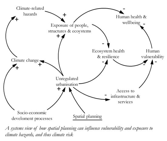


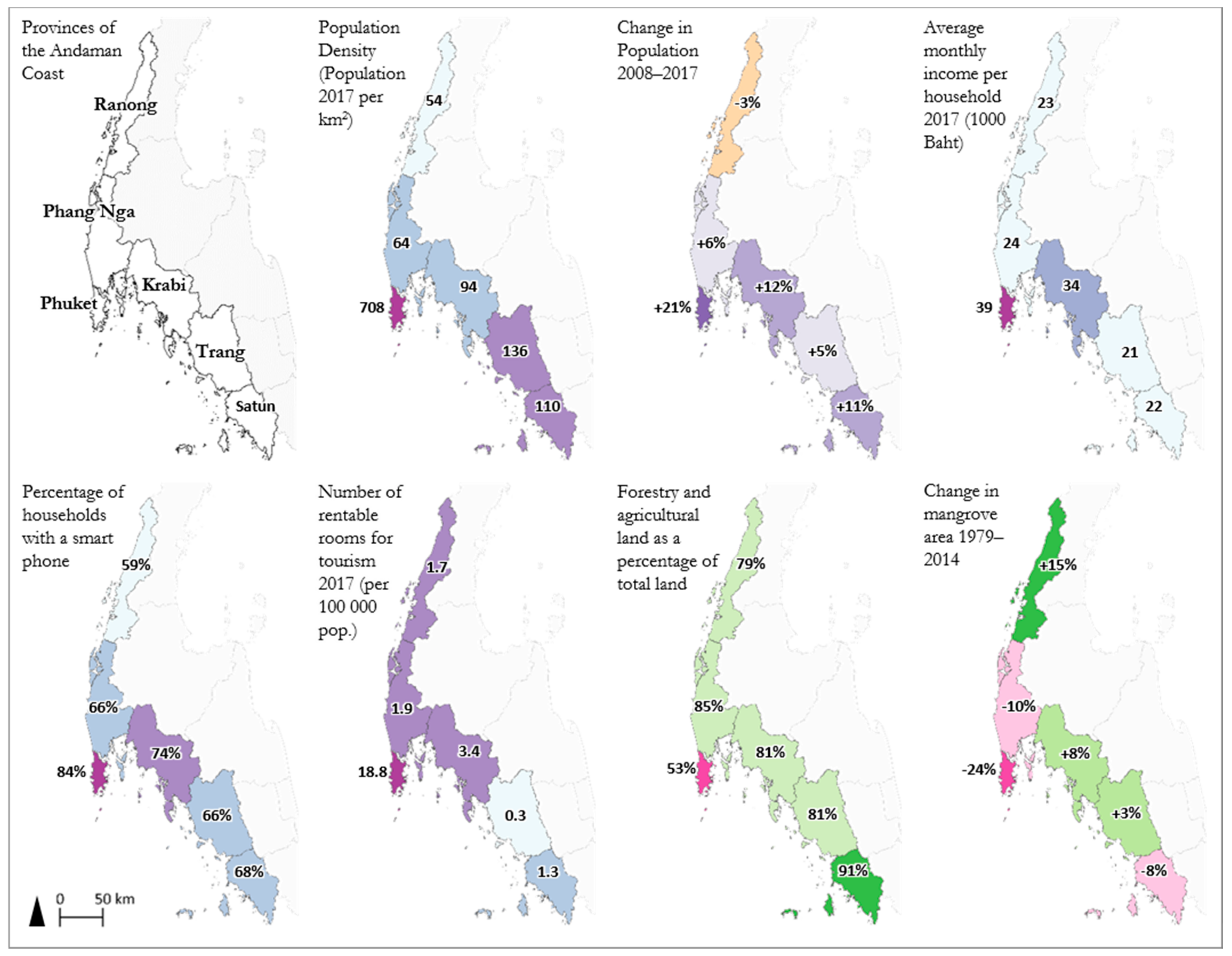
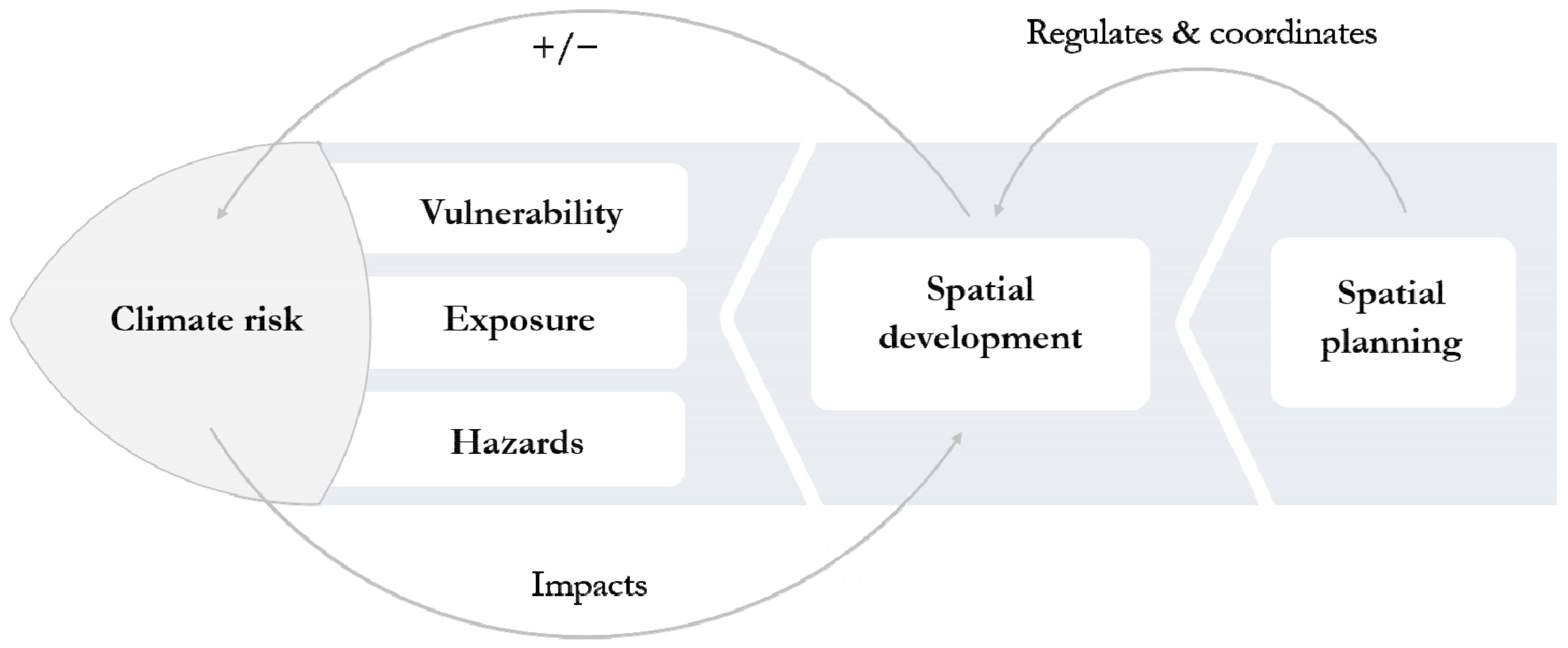
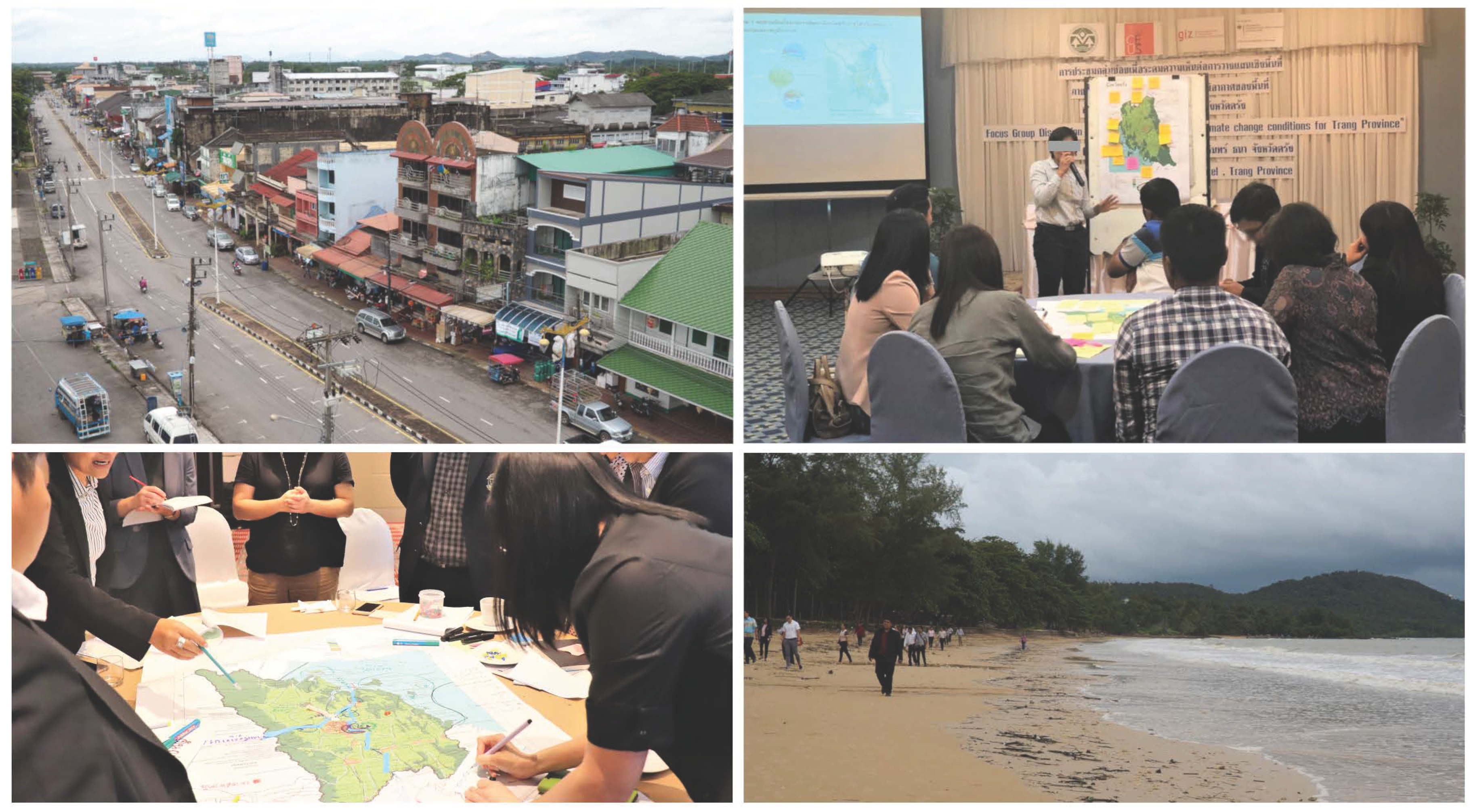
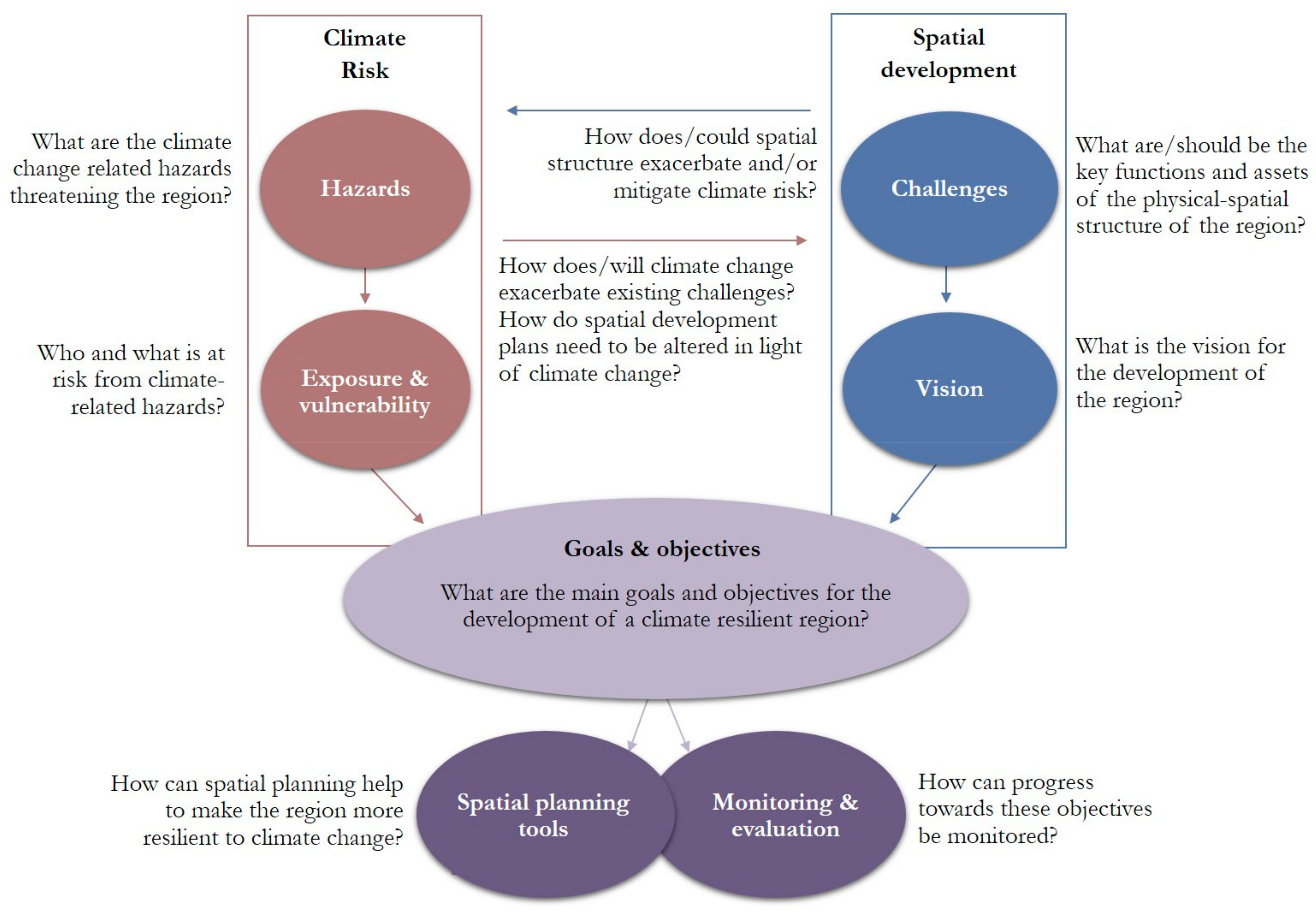
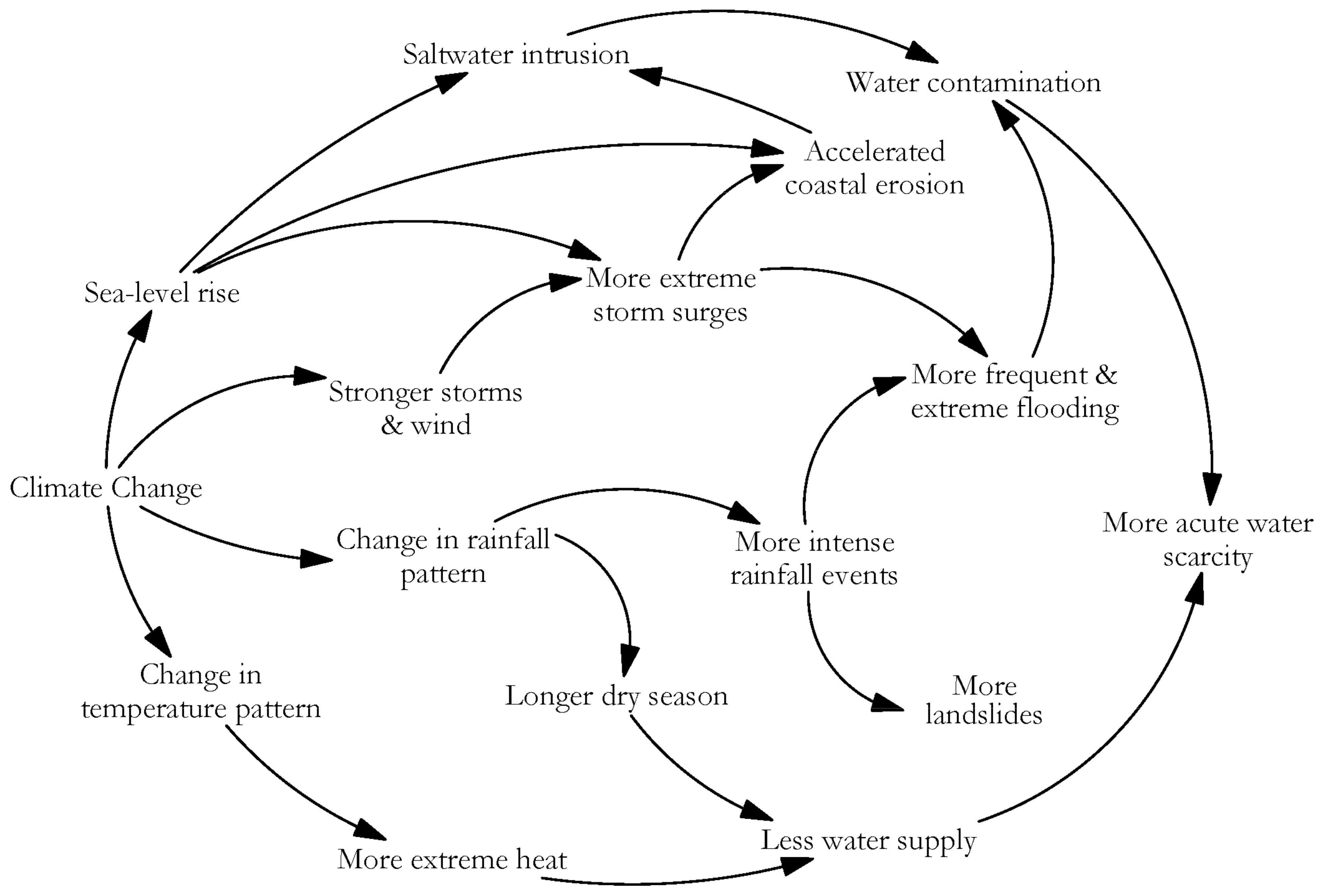
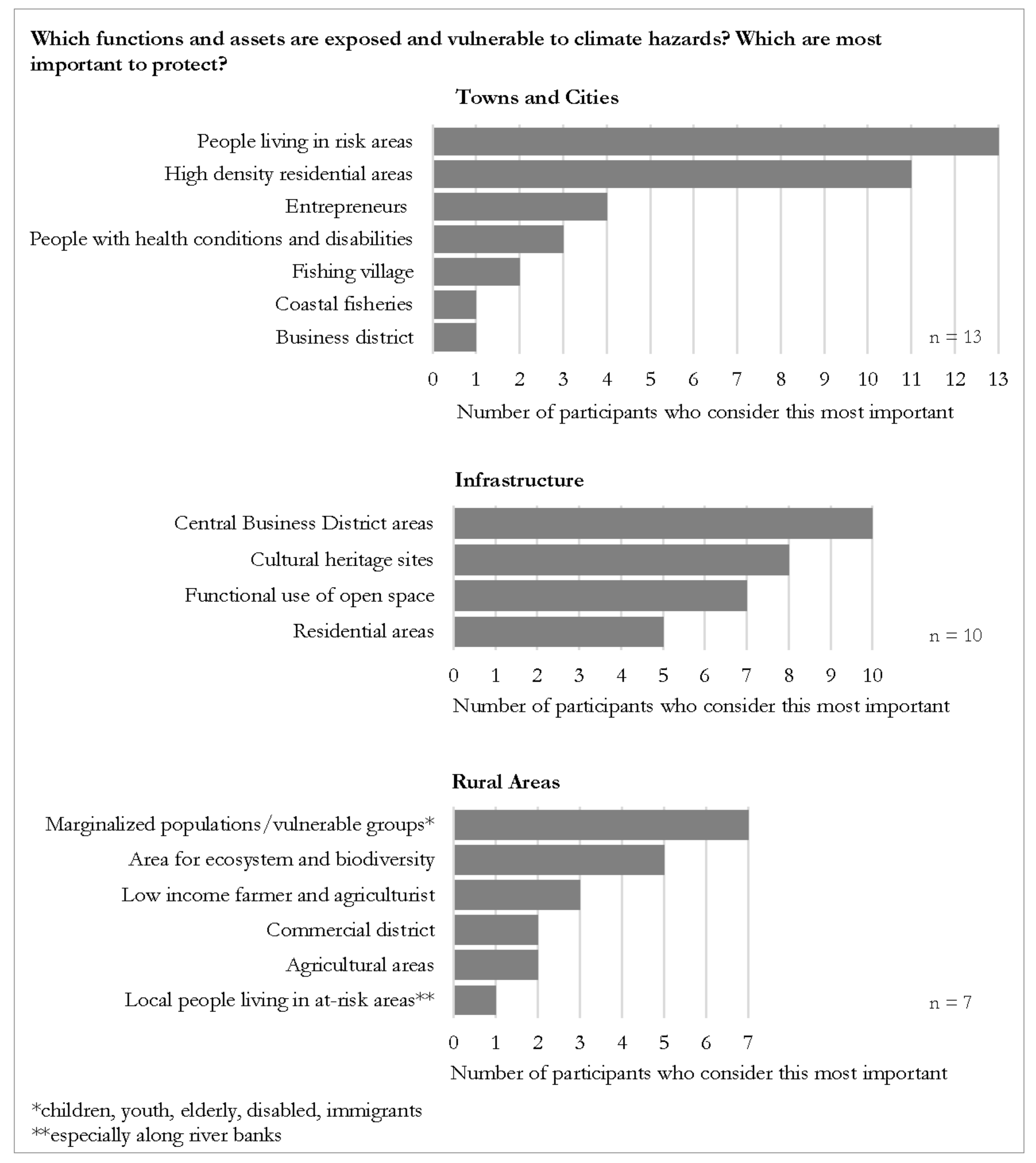
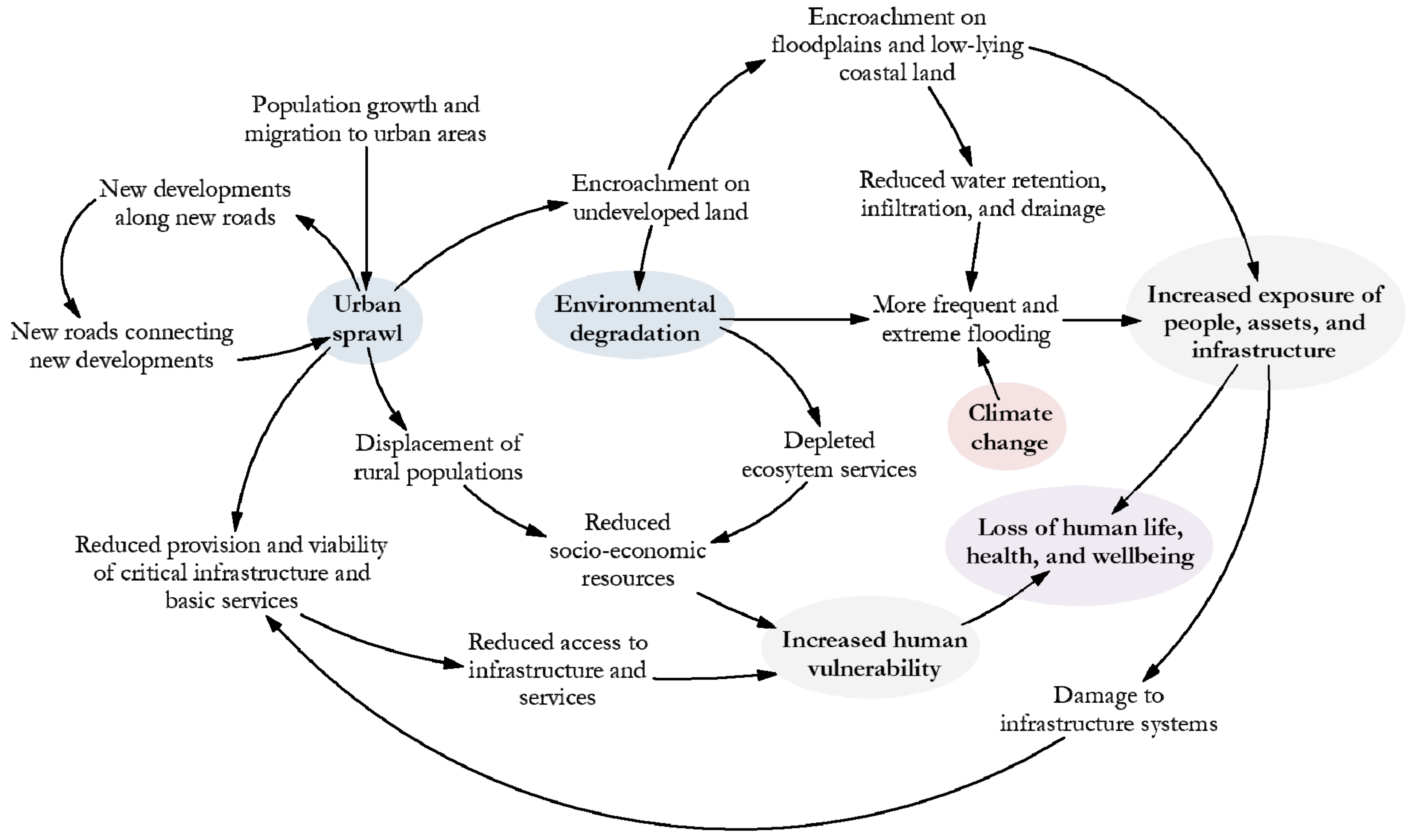
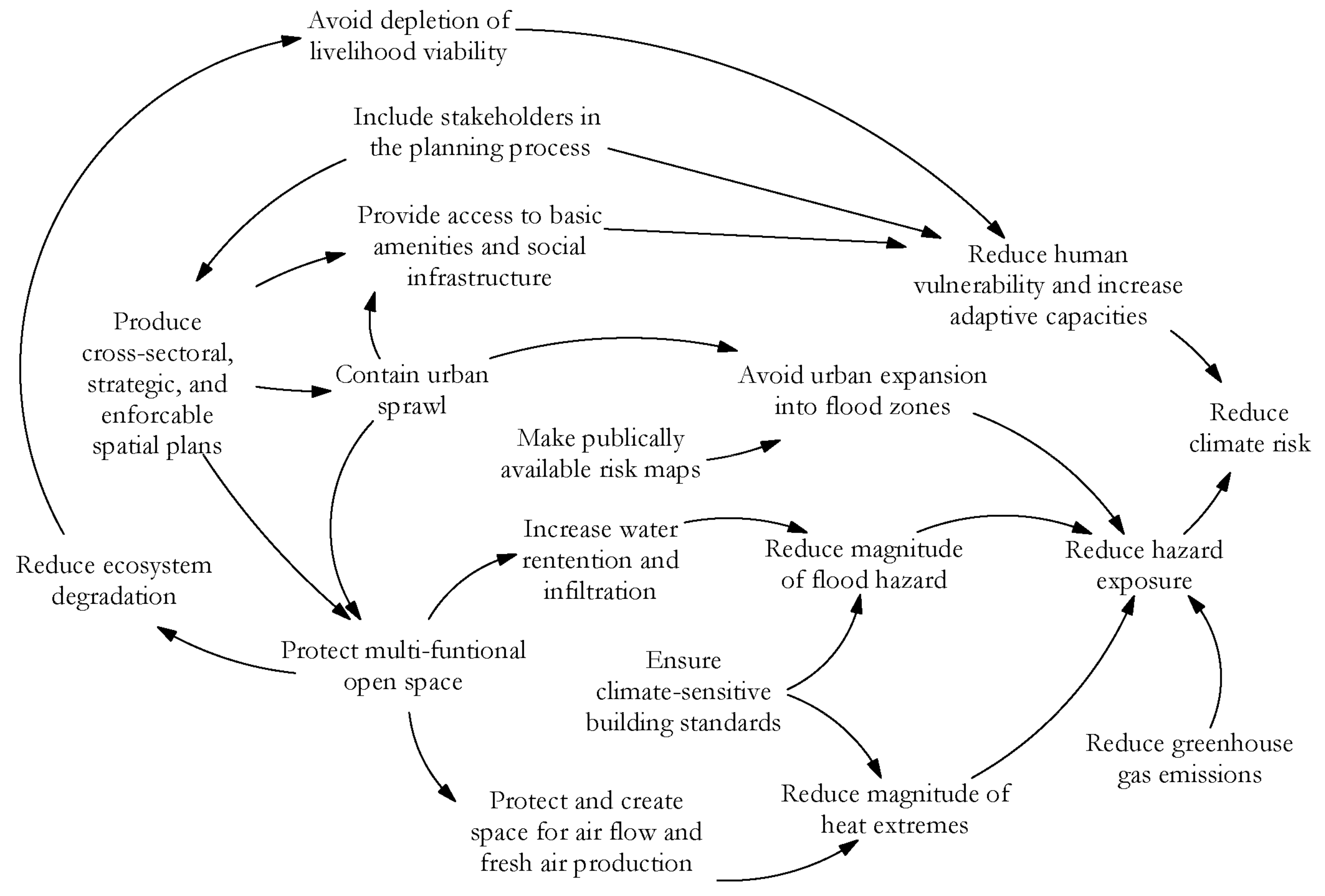