
Examination of Local Plan Changes from a Value Capture Perspective: Istanbul Case

Abstract
:1. Introduction
2. Value Capturing Policy and the Betterment—Compensation Balance
3. Value Capture Policy on Plan Changes in Turkey
4. Analysis of Local Plan Changes from a Value Capture Perspective: Istanbul Case
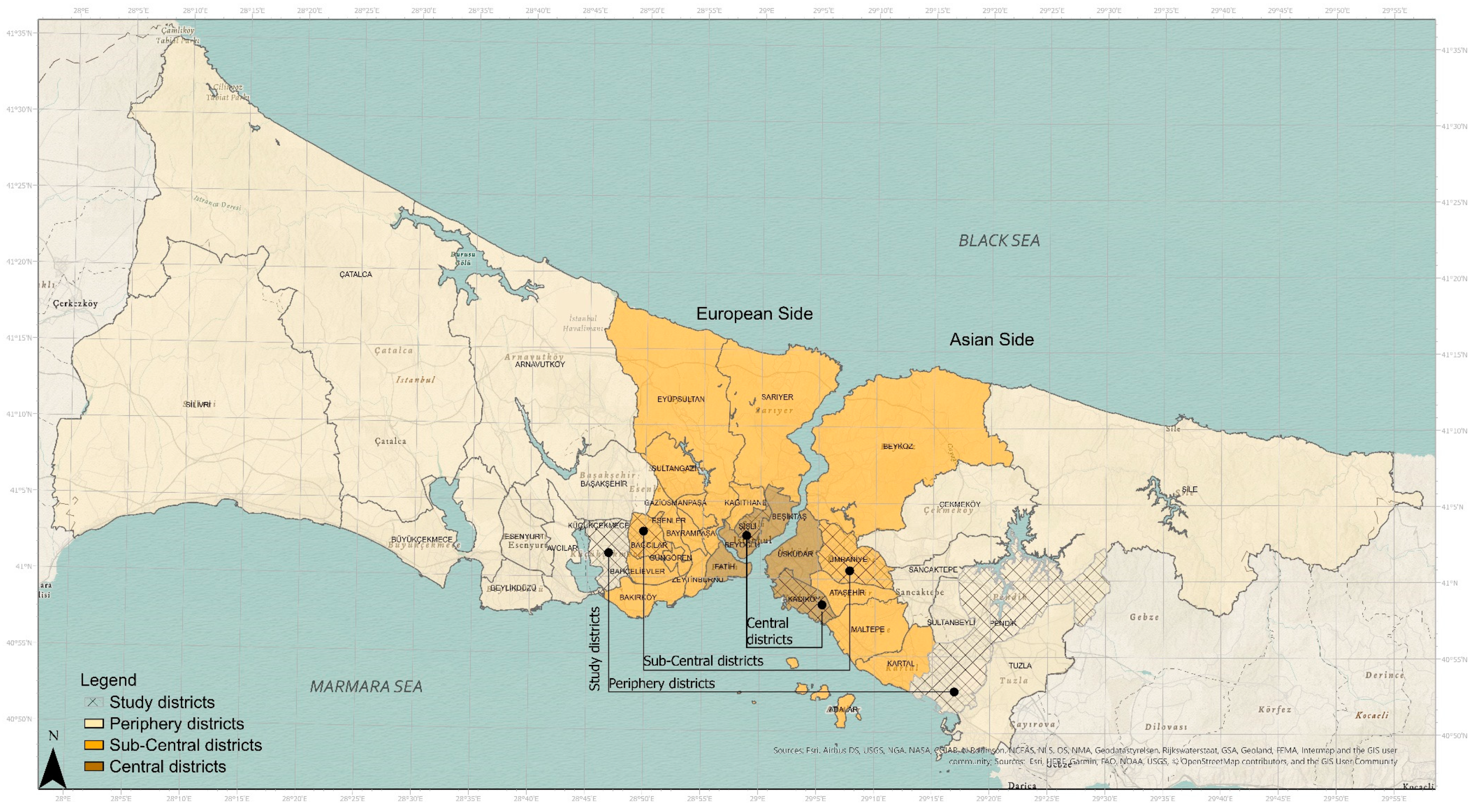
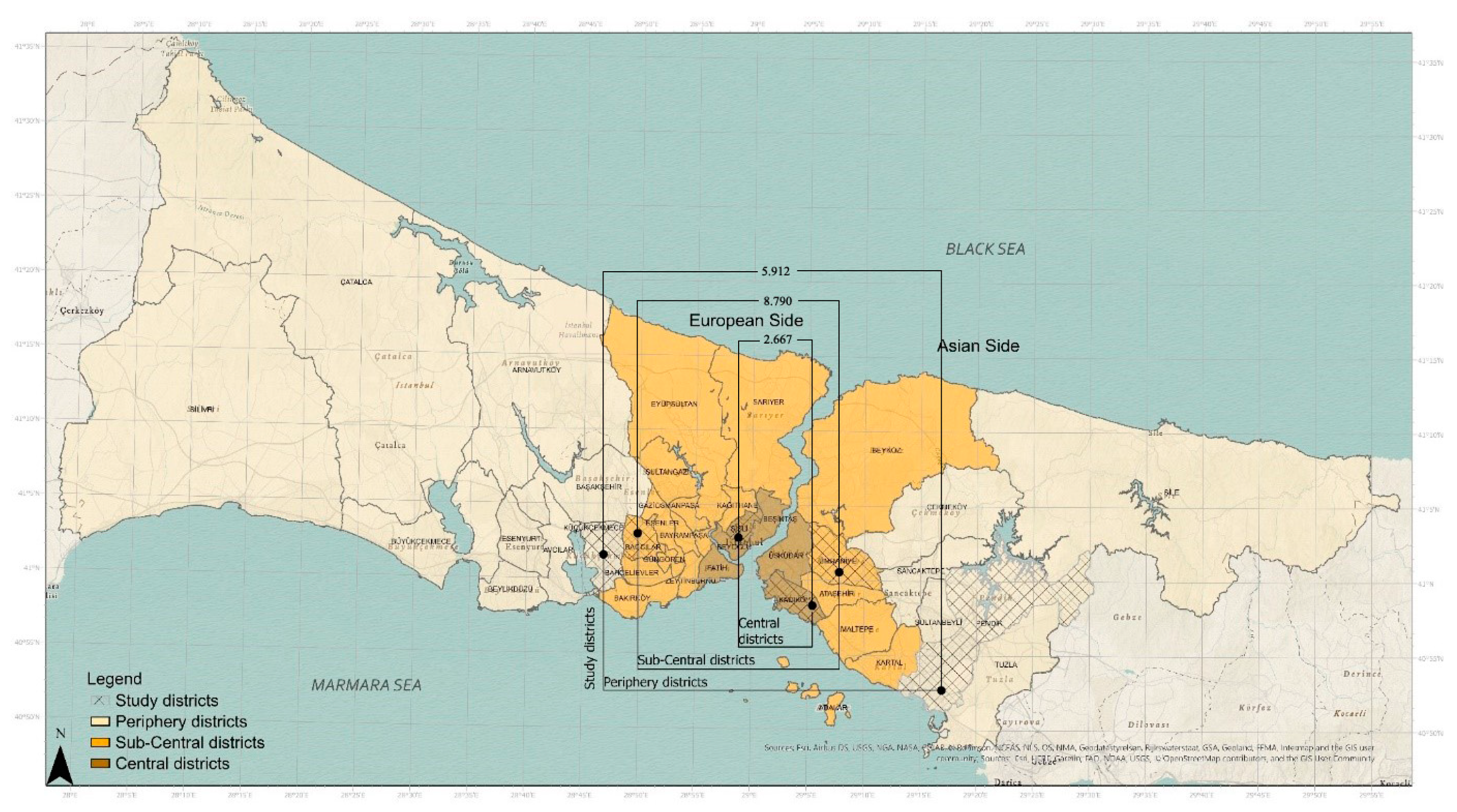
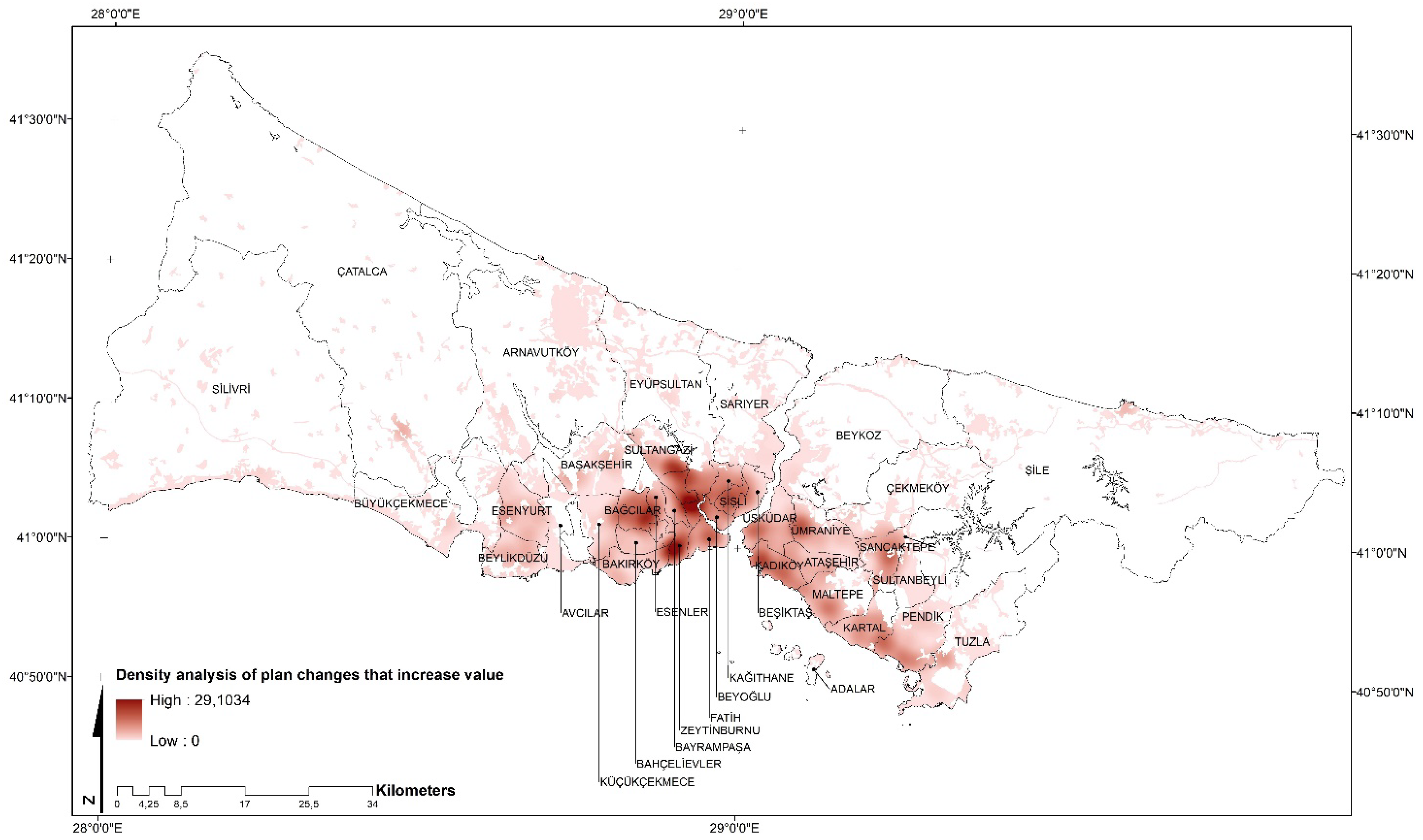
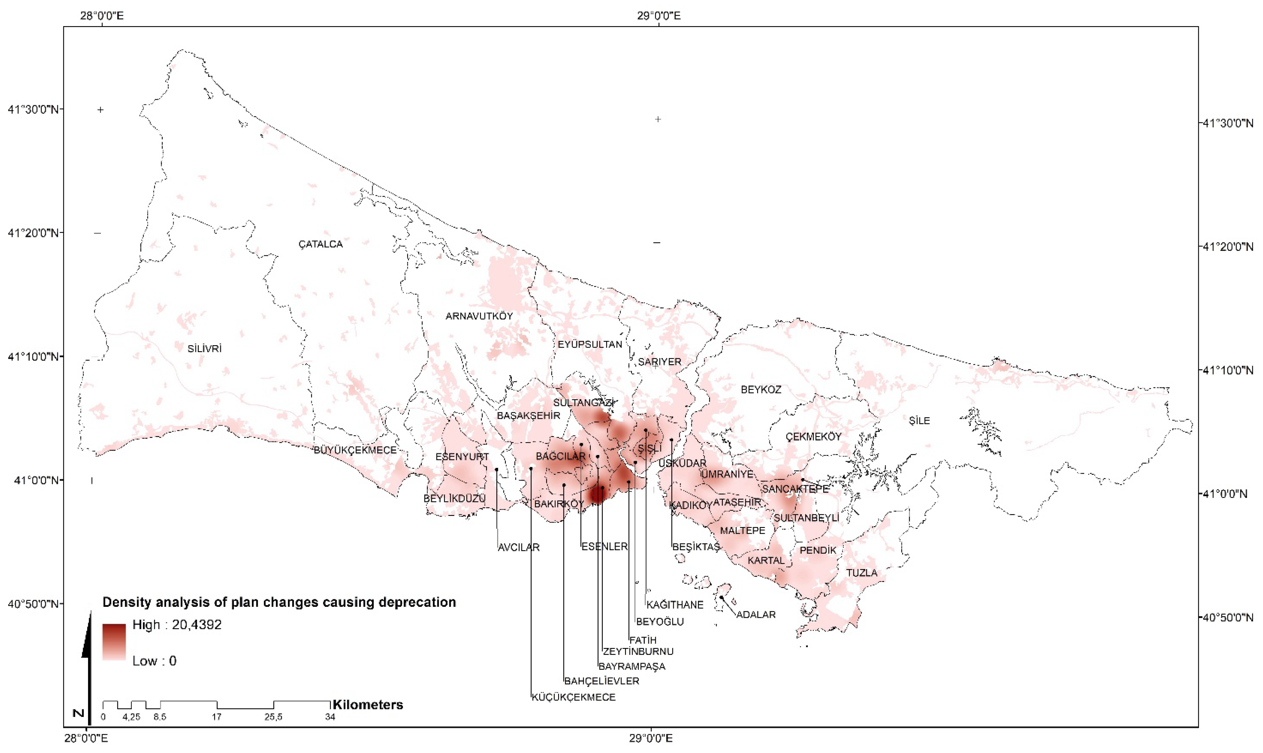
4.1. Study Area
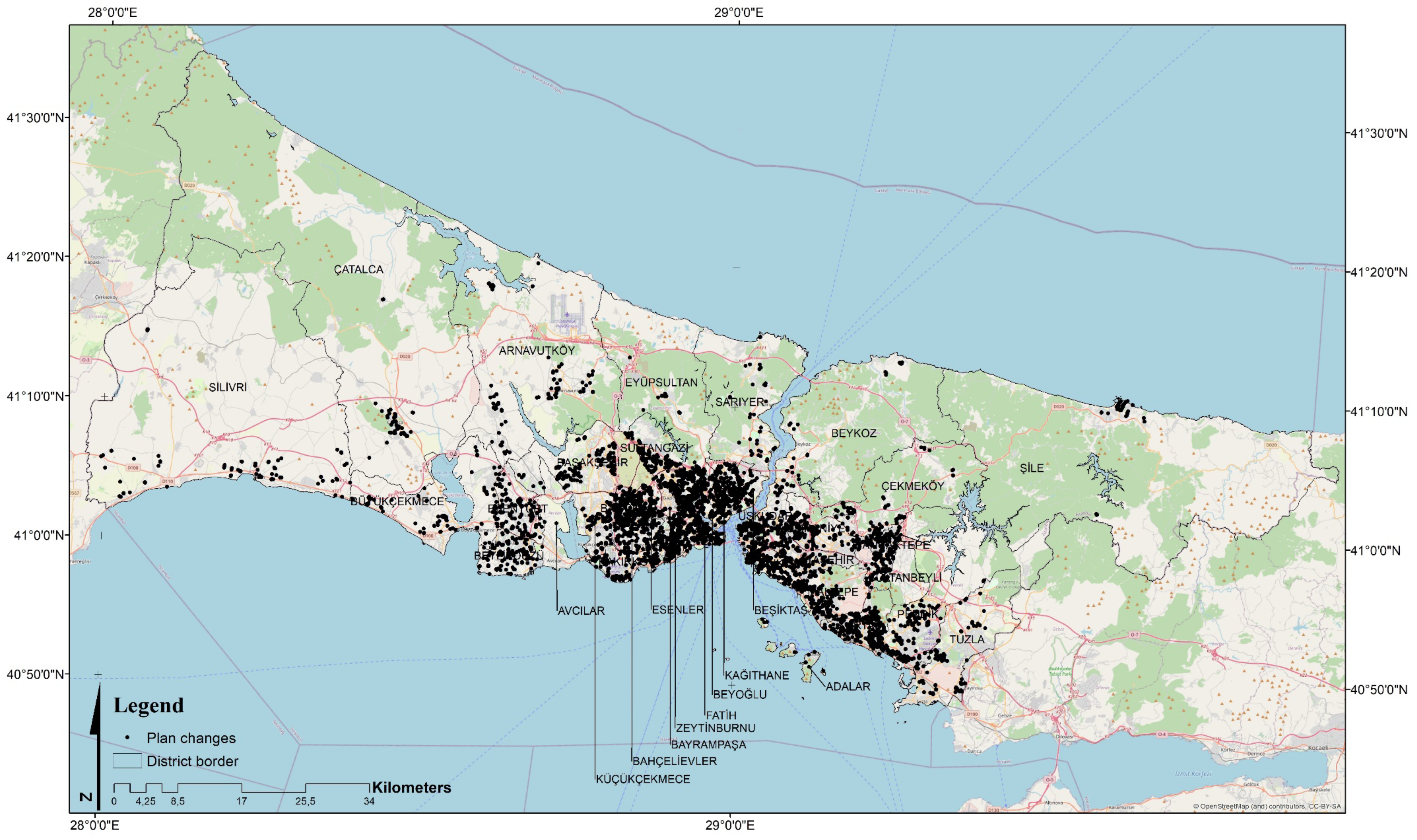
4.2. Methodology
4.3. Findings
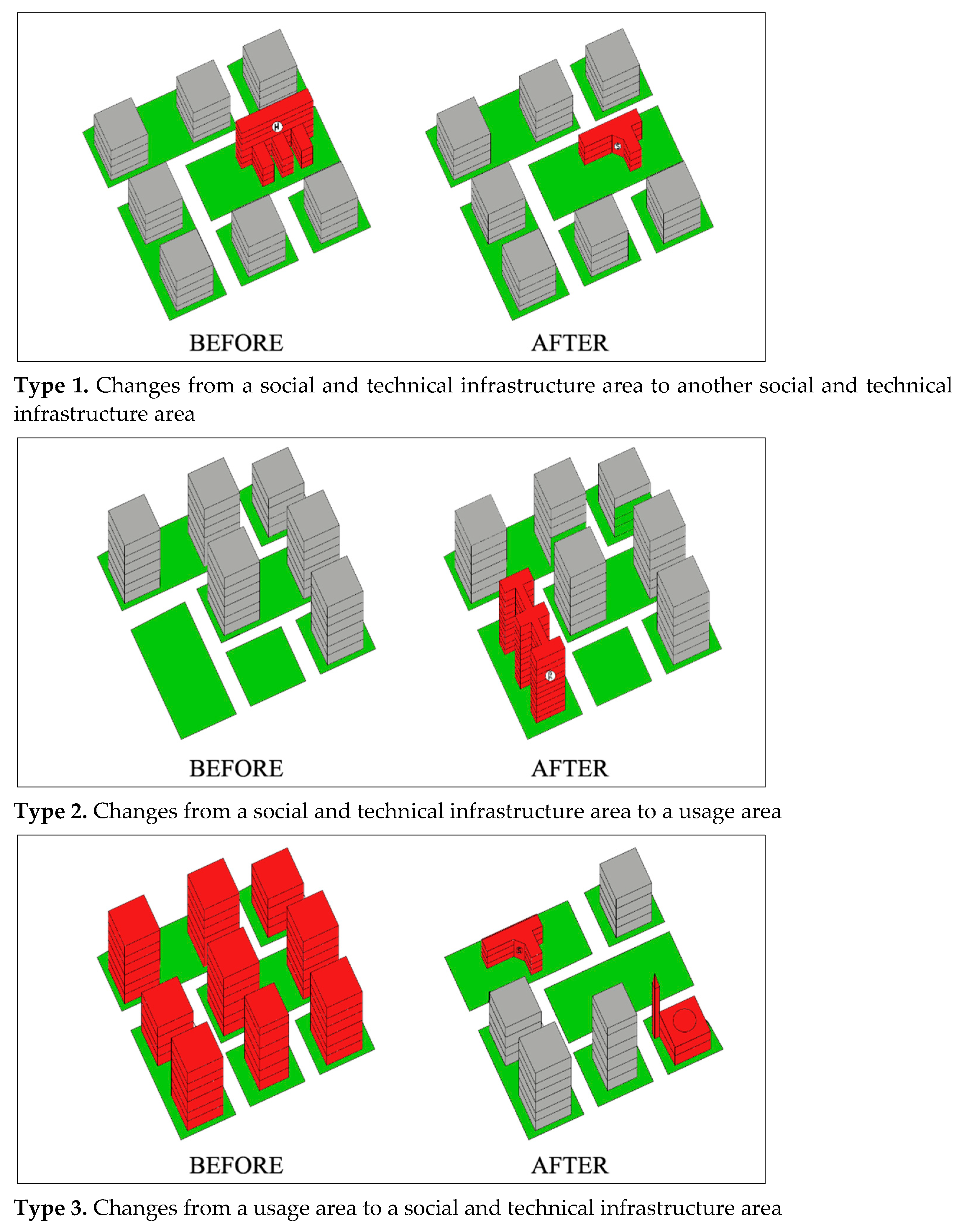
4.3.1. First Stage: Classification of the Plan Changes
4.3.2. The Second Stage: The Value Capture Content of Each Group
5. Discussion
6. Conclusions
Author Contributions
Funding
Institutional Review Board Statement
Informed Consent Statement
Data Availability Statement
Conflicts of Interest
References
- Nguyen, T.B.; Van der Krabben, E.; Spencer, J.H.; Truongd, K.T. Collaborative development: Capturing the public value in private real estate development projects in Ho Chi Minh City, Vietnam. Cities 2017, 68, 104–118. [Google Scholar] [CrossRef] [Green Version]
- Havel, M.B. How the distribution of rights and liabilities in relation to betterment and compensation links with planning and the nature of property rights: Reflections on the Polish experience. Land Use Policy 2017, 67, 508–516. [Google Scholar] [CrossRef]
- Alterman, R. Levying the Land: Land-based instruments for public revenue and their applicability to developing countries. In Proceedings of the UN Habitat Governing Council Meeting, Nairobi, Kenya, 15–17 April 2013. [Google Scholar]
- Smolka, M.O. Implementing Value Capture in Latin America: Policies and Tools for Urban Development; Lincoln Institute of Land Policy: Cambridge, MA, USA, 2013. [Google Scholar]
- Ingram, G.K.; Hong, Y.H. Value capture and land policies. In Proceedings of the 2011 Land Policy Conference, Lincoln Institute of Land Policy, Cambridge, MA, USA, 3–5 June 2012. [Google Scholar]
- Fensham, P.; Gleeson, B. Capturing Value for Urban Management: A New Agenda for Betterment. Urban Policy Res. 2003, 21, 93–112. [Google Scholar] [CrossRef]
- Catney, P.; Henneberry, J. Change in the political economy of land value capture in England. Town Plan. Rev. 2019, 90, 339–358. [Google Scholar] [CrossRef]
- Friendly, A. Land Value Capture and Social Benefits: Toronto and São Paulo Compared. IMFG Pap. Munic. Financ. Gov. 2017, 33, 1–49. [Google Scholar]
- Muñoz Gielen, D.; Salas, I.M.; Cuadrado, J.B. International comparison of the changing dynamics of governance approaches to land development and their results for public value capture. Cities 2017, 71, 123–134. [Google Scholar] [CrossRef]
- Muñoz Gielen, D.; Ossowicz, T.; Zaborowski, T. The failing public value capture in Polish urban development. In Proceedings of the Conference ‘Everything in its place—Empowering Local and Regional Communities’, Warsaw, Poland, 27–30 June 2019. [Google Scholar]
- Alexander, E. Institutional Design for Value Capture and a Case: The Tel-Aviv Metropolitan Park. Int. Plan. Stud. 2012, 17, 163–177. [Google Scholar] [CrossRef]
- Rauscher, R. Renewing Cities with Value Capture Planning Model for Achieving Equitable Housing, Public and Open Spaces, and Sustainable Transport; Springer: Berlin/Heidelberg, Germany, 2021. [Google Scholar]
- Ökmen, M.; Yurtsever, H. Kentsel Planlama Sürecinde Oluşan Kamusal Rantın Vergilendirilmesi (Taxation of Public Rents in the Urban Planning Process). Maliye Derg. 2010, 158, 58–74. (In Turkish) [Google Scholar]
- Ferm, J.; Raco, M. Viability Planning, Value Capture and the Geographies of Market-Led Planning Reform in England. Plan. Theory Pract. 2020, 21, 218–235. [Google Scholar] [CrossRef]
- UN-Habitat. The Challenge of Local Government Financing of Developing Countries; United Habitat: Nairobi, Kenya, 2018. [Google Scholar]
- UN-Habitat. Habitat III-New Urban Agenda; United Habitat: Nairobi, Kenya, 2016; p. 22. [Google Scholar]
- UN-Habitat. Quito declaration on sustainable cities and human settlements for all. In A New Urban Agenda; United Habitat: Nairobi, Kenya, 2016. [Google Scholar]
- Tarakçı, S.; Turk, S.S. Public value capturing in urban renewal: The fkirtepe case (Istanbul, Turkey). J. Hous. Built Environ. 2021, 36, 1–31. [Google Scholar]
- Suzuki, H.; Murakami, J.; Hong, Y.-H. Tamayose, B. Financing Transit-Oriented Development with Land Values: Adapting Land Value Capture in Developing Countries; World Bank Publications: Washington, DC, USA, 2015. [Google Scholar]
- Peterson, G.E. Unlocking Land Values to Finance Urban Infrastructure: Land-Based Financing Options for Cities Trends and Policy Options; World Bank: Washington, DC, USA, 2009. [Google Scholar]
- George, H. Progress and Poverty: An Inquiry into the Cause of Industrial Depressions, and of Increase of Want with Increase of Wealth, The Remendy; Francis Greenwood Peabody Endowment Fund: New York, NY, USA, 1888. [Google Scholar]
- Baumann, A. Betterment, Worsement and Recoupment; Edward Stanford: London, UK, 1894. [Google Scholar]
- Booth, P. Planning by Consent: The Origins and Nature of British Development Control; Routledge: London, UK, 2003. [Google Scholar]
- Mualam, N.; Hendricks, A.; Maliene, V.; Salinger, E. Value Capture and Vertical Allocations of Public Amenities. Sustainability 2021, 13, 3952. [Google Scholar] [CrossRef]
- McAllister, P. The taxing problems of land value capture, planning obligations and viability tests: Some reasonable models? Town Plan. Rev. 2019, 90, 429–451. [Google Scholar] [CrossRef]
- Hendricks, A.; Lacoere, P.; Krabben, E.v.d.; Oorschot, C. Limits of negotiable developer obligations. Sustainability 2021, 13, 11364. [Google Scholar] [CrossRef]
- Turk, S.S. Comparison of the impacts of non-negotiable and negotiable developer obligations in Turkey. Habitat Int. 2018, 75, 122–130. [Google Scholar] [CrossRef]
- Huxley, J. Value Capture Finance Making Urban Development Pay Its Way. Available online: http://uli.org/wp-content/uploads/ULI-Documents/Value-CaptureFinance-Report.pdf (accessed on 4 September 2021).
- Smolka, M.O.; Amborski, D. Value Capture for Urban Development: An Inter American Comparison; Lincoln Institute of Land Policy: Cambridge, MA, USA, 2000. [Google Scholar]
- Van der Krabben, E.; Needham, B. Land readjustment for value capturing. Town Plan. Rev. 2008, 79, 651–672. [Google Scholar] [CrossRef]
- Garza, N.; Gonzalez, I. An urban system assessment of Land Value Capture: The Colombian case. Land Use Policy 2021, 109, 105598. [Google Scholar] [CrossRef]
- Margalit, T. Multi-spot zoning: A chain of public–private development ventures in Tel Aviv. Cities 2014, 37, 73–81. [Google Scholar] [CrossRef]
- Smith, J.J.; Gihring, T.A. Financing transit systems through value capture: An annotated bibliography. Am. J. Econ. Sociol. 2006, 65, 751–786. [Google Scholar] [CrossRef]
- Cervero, R. Rail transit and joint development: Land market impacts in Washington, D.C. and Atlanta. J. Am. Plan. Assoc. 1994, 60, 83–94. [Google Scholar] [CrossRef]
- Kim, M. Upzoning and value capture: How, U.S. local governments use land use regulation power to create and capture value from real estate developments. Land Use Policy 2020, 95, 104624. [Google Scholar] [CrossRef]
- Muñoz Gielen, D.; Tasan-Kok, T. Flexibility in Planning and the Consequences for PublicValue Capturing in UK, Spain and the Netherlands. Eur. Plan. Stud. 2010, 18, 1097–1131. [Google Scholar] [CrossRef] [Green Version]
- Hagman, D.G.; Misczynski, D.J. Windfalls for Wipeouts: Land Value Recapture and Compensation, Chicago; American Society Planning Association: Chicago, IL, USA, 1978. [Google Scholar]
- Taşan-Kok, T. Changing interpretations of ‘flexibility’ in the planning literature: From opportunism to creativity? Int. Plan. Stud. 2008, 13, 183–195. [Google Scholar] [CrossRef]
- Dannestam, T. Rethinking Local Politics: Towards a Cultural Political Economy of Entrepreneurial Cities. Space Polity 2008, 12, 353–372. [Google Scholar] [CrossRef]
- Alterman, R. Takings International: A Comparative Perspective on Land Use Regulations and Compensation Rights, Chicago; American Bar Association Publications: Chicago, IL, USA, 2010; ISBN 1604425504. [Google Scholar]
- Dona, C.R. A tale of three takings: Taking analysis in land use regulation in the United States, Australia and Canada. Brooklyn J. Int. Law 2007, 32, 343–403. [Google Scholar]
- Gregory, S.A. The Global Debate Over Constıtutıonal Property: Lessons for American Takings Jurisprudence; University of Chicago Press: Chicago, IL, USA, 2006. [Google Scholar]
- Murray, J.R. Planning Law and Compulsory Acquisition in Australia, in Taking Land: Compulsory Purchase and Regulation. In Asian-Pacific Countries; Kotaka, T., Callies, D.L., Eds.; University of Hawaii Press: Honolulu, HI, USA, 2002; pp. 27–74. [Google Scholar]
- Dowal, D. Windfalls for Wipeouts: Land Value Capture and Compensation by Donald Hagman and Dean Misczynski; University of California: Berkeley, CA, USA, 1979. [Google Scholar]
- Penpecioğlu, M.; Taşan-Kok, T. Alienated and Politicized? Young Planners’ Confrontation with Entrepreneurial and Authoritarian State Intervention in Urban Development in Turkey. Eur. Plan. Stud. 2016, 24, 1037–1055. [Google Scholar] [CrossRef] [Green Version]
- Balaban, O. The negative effects of construction boom on urban planning and environment in Turkey: Unraveling the role of the public sector. Habitat Int. 2012, 36, 26–35. [Google Scholar] [CrossRef]
- Tansel, C.B. Reproducing authoritarian neoliberalism in Turkey: Urban governance and state restructuring in the shadow of executive centralization. Globalizations 2018, 16, 320–335. [Google Scholar] [CrossRef] [Green Version]
- Yaylı, H. Küreselleşmenin kentler üzerine etkisi: “Istanbul örneği” (The effect of globalization on cities: The case of Istanbul). Sosyal Ekonomik Araştırmalar Dergisi 2012, 12, 331–356. (In Turkish) [Google Scholar]
- Yıldırım, S. 2008 Yılı küresel ekonomi krizinin dünya ve türkiye ekonomisine etkileri (the effects of the 2008 global economic crisis on the world and Turkish economy). Karamanoğlu Mehmetbey Üniversitesi Sos. Ve Ekon. Araştırmalar Derg. 2010, 12, 47–55. (In Turkish) [Google Scholar]
- Kılınc, N.; Turk, S.S. Plan changes in Istanbul (Turkey) as project-led practices in a plan-led planning system. Eur. Plan. Stud. 2021, 29, 1393–1418. [Google Scholar] [CrossRef]
- Muñoz Gielen, E.; Van der Krabben, E. Public Infrastructure. Private Finance; Routledge: Oxfordshire, UK, 2019. [Google Scholar]
- Ronald, H.R. The changing culture of American land use regulation: Paying for growth with impact fees. South. Methodist Univ. Law Rev. 2006, 59, 177–263. [Google Scholar]
- Gielen, D.M. Capturing Value Increase in Urban Redevelopment. A Study of How the Economic Value Increase in Urban Redevelopment Can Be Used to Finance the Necessary Public Infrastructure and Other Facilities; Sidestone Press: Leiden, The Netherlands, 2010. [Google Scholar]
- Dransfeld, E.; Voss, W. Funktionsweise Staedtischer Boden-Maerkte in Mitgliedstaaten der Europaeischen Gemeinschaft—Ein Systemver—Gleich; Universitaet Dortmund: Dortmund, Germany, 1993; p. 327. [Google Scholar]
- Alterman, R. Is Capturing the "Unearned Increment" in Land Value Still a Viable Idea? A Cross-National Analysis; Oxford Univesity Press: Oxford, UK, 2012; Volume 33, pp. 755–786. [Google Scholar]
- Ünlü, T. Managing the Urban Change: A Morphological Perspective for Planning. ICONARP Int. J. Archit. Plan. 2019, 7, 55–72. [Google Scholar] [CrossRef]
- Şişman, A.; Öztürk, D.; Şişman, Y.; Maraşlı, E. İmar Planı Değişikliklerinin Yaşam Alanları Üzerindeki Etkisinin İncelenmesi (Investigation of the Impact of Plan Changes on Living Areas). TUCAUM VI. 2008. Available online: http://tucaum.ankara.edu.tr/wp-content/uploads/sites/280/2015/08/semp6_2.pdf (accessed on 3 December 2021). (In Turkish).
- Keskin, Z. İstanbul’da Arazi Değerlerinin Mekânsal Dağılımının Nüfus, İstihdam ve Ulaşım Açısından Analizi. Yüksek Lisans Tezi; İstanbul Teknik Üniversitesi: İstanbul, Turkey, 2007. [Google Scholar]
- Ünlü, T. Mersin’de değişen kentsel mekân: Çamlıbel’de morfolojik değişim (Changing Urban Space in Mersin: Morphological Change in Çamlıbel). Megaron 2006, 1, 178–200. (In Turkish) [Google Scholar]
- Kılınçaslan, İ. Kentleşmenin Ekonomik Yönleri; İstanbul Teknik Üniversitesi Matbaası: İstanbul, Turkey, 2002. [Google Scholar]
- IMM (İstanbul Metropoliten Municipality). 11/100,000 Scale Istanbul Environmental Plan; İstanbul Metropoliten Municipality: Istanbul, Turkey, 2009. [Google Scholar]
- Sassen, S. Some Insights from a More Regulated System. Town Plan. Rev. 1992, 63, 387–402. [Google Scholar]
- Parkinson, M.; Judd, D. (Eds.) Leadership and Urban Regeneration; Sage: Newbury Park, CA, USA, 1990. [Google Scholar]
- David, H. Sermayenin Mekânları, Eleştirel bir Coğrafyaya Doğru (Spaces of Capital, Towards a Critical Geography); Sel Pub.: Istanbul, Turkey, 2012. (In Turkish) [Google Scholar]
- Douglass, M. Mega-urban regions and world city formation: Globalisation, the economic crisis and urban policy ıssues in Pacific Asia. Urban Stud. 2000, 37, 2315–2335. [Google Scholar] [CrossRef]
- Berköz, L.; Eyüboglu, E. Intrametropolitan location of producer-service FDI in Istanbul. Eur. Plan. Stud. 2007, 15, 357–381. [Google Scholar] [CrossRef]
- Tekeli, İ. Türkiye Kent Planlamasının Yeniden Kurumsallaşmasını Düzenlerken Düşünülmesi Gerekenler Üzerine. Planlama Dergisi 2012, 3–4, 53. [Google Scholar]
- Turk, S.S.; Korthals Altes, W.K. Institutional capacities in the land development for housing on greenfield sites in Istanbul. Habitat Int. 2010, 34, 183–195. [Google Scholar] [CrossRef]
- Karaman, O. Urban Neoliberalism with Islamic Characteristics. Urban Stud. 2013, 50, 3412–3427. [Google Scholar] [CrossRef]
- Lovering, J.; Türkmen, H. Bulldozer neo-liberalism in Istanbul: The state-led construction of property markets, and the displacement of the urban poor. Int. Plan. Stud. 2011, 16, 73–96. [Google Scholar] [CrossRef]
- Özus, E.; Türk, Ş.Ş.; Dökmeci, V. Urban Restructuring of Istanbul. Eur. Plan. Stud. 2011, 19, 331–356. [Google Scholar] [CrossRef]
- Alkay, E.; Watkins, C.; Keskin, B. Explaining Spatial Variation in Housing Construction Activity in Turkey. Int. J. Strateg. Prop. Manag. 2018, 22, 119–130. [Google Scholar] [CrossRef] [Green Version]
- Çelikbilek, A. Mega Projelerin Mekânsal ve Ekonomik Coğrafyasının Incelenmesi: İstanbul Örneği; Yüksek Lisans Tezi, Yıldız Teknik Üniversitesi: İstanbul, Turkey, 2019. [Google Scholar]
- Dogan, E.; Stupar, A. The limits of growth: A case study of three mega-projects in Istanbul. Cities 2017, 60, 281–288. [Google Scholar] [CrossRef]
- Penpecioğlu, M. Kapitalist Kentleşme Dinamiklerinin Türkiye’deki Son 10 Yılı: Yapılı Çevre Üretimi, Devlet ve Büyük Ölçekli Projeler. Birikim 2011, 270, 62–73. [Google Scholar]
- Özkan, A.; Türk, S.S. Emergence, formation and outcomes of flexibility in Turkish planning practice. Int. Dev. Plan. Rev. 2016, 38, 25–54. [Google Scholar] [CrossRef]
- Gülümser, A.; Baycan, T. Gated communities in Istanbul: The new walls of the city. Town Plan. Rev. 2011, 38, 87–109. [Google Scholar]
- Dökmeci, V.; Berköz, L. Transformation of Istanbul from a monocentric to a polycentric city. Eur. Plan. Stud. 1994, 2, 193–205. [Google Scholar] [CrossRef]
- Cengiz, S.; Atmış, E.; Görmüş, S. The impact of economic growth oriented development policies on landscape changes in Istanbul Province in Turkey. Land Use Policy 2019, 87, 104086. [Google Scholar] [CrossRef]
- Turkstat. Adrese Dayalı Nüfus Kayıt Sistemi Sonuçları. Available online: https://biruni.tuik.gov.tr/medas/?kn=95&locale=tr (accessed on 24 August 2020).
- Turk, S.S. An Analysis on the Efficient Applicability of the Land Readjustment (LR) Method in Turkey. Habitat Int. 2007, 31, 53–64. [Google Scholar] [CrossRef]


| Interview No/Date | Academician | Interview No/Date | Public Sector | Interview No/Date | Private Sector |
|---|---|---|---|---|---|
| Interview-1 11 March 2019 | Academician, Professor Istanbul Technical University | Interview-17 25 March 2019 | Ministry of Environment and Urbanization (Director) | Interview-32 22 March 2019 | Owner of Planning Office |
| Interview-2 12 March 2019 | Academician, Professor Istanbul Technical University | Interview-18 25 March 2019 | Ministry of Environment and Urbanization | Interview-33 24 March 2019 | Owner of Planning Office |
| Interview-3 18 March 2019 | Academician, Professor Istanbul University | Interview-19 27 March 2019 | Istanbul Metropolitan Municipality (Director) | Interview-34 24 March 2019 | Owner of Planning Office |
| Interview-4 4 April 2019 | Academician, Professor Istanbul University | Interview-20 27 March 2019 | Istanbul Metropolitan Municipality (Chief) | Interview-35 25 March 2019 | Owner of Planning Office |
| Interview-5 8 April 2019 | Academician, Professor Sakarya University | Interview-21 27 March 2019 | Istanbul Metropolitan Municipality | Interview-36 2 April 2019 | Owner of Planning Office |
| Interview-6 11 March 2019 | Academician, Assoc. Professor Istanbul Technical University | Interview-22 12 March 2019 | Fatih Municipality (Director) | Interview-37 3 April 2019 | Owner of Planning Office |
| Interview-7 13 March 2019 | Academician, Assoc. Professor Istanbul University | Interview-23 14 March 2019 | Pendik Municipality (Chief) | Interview-38 22 March 2019 | Employed in Planning Office |
| Interview-8 15 March 2019 | Academician, Assoc. Professor Yıldız Technical University | Interview-24 14 March 2019 | Üsküdar Municipality (Director) | Interview-39 22 March 2019 | Employed in Planning Office |
| Interview-9 18 March 2019 | Academician, Assoc. Professor Istanbul University | Interview-25 15 March 2019 | Kadıköy Municipality (Director) | Interview-40 22 March 2019 | Employed in Planning Office |
| Interview-10 20 March 2019 | Academician, Assoc. Professor Marmara University | Interview-26 19 March 2019 | Istanbul Registry Office | Interview-41 24 March 2019 | Employed in Planning Office |
| Interview-11 21 March 2019 | Academician, Assoc. Professor Fatih Sultan Mehmet University | Interview-27 13 March 2019 | Ministry of Culture and Tourism (Director) | Interview-42 24 March 2019 | Employed in Planning Office |
| Interview-12 19 March 2019 | Academician, Assist. Professor Gebze Technical University | Interview-28 13 March 2019 | Ministry of Culture and Tourism | Interview-43 25 March 2019 | Employed in Planning Office |
| Interview-13 13 March 2019 | Academician, Assist. Professor Yıldız Technical University | Interview-29 2 April 2019 | TOKİ (Mass Housing Autority) (Chief) | Interview-44 25 March 2019 | Employed in Planning Office |
| Interview-14 14 March 2019 | Academician, Assist. Professor Konya Technical University | Interview-30 2 April 2019 | TOKİ (Mass Housing Autority) | Interview-45 2 April 2019 | Employed in Planning Office |
| Interview-15 18 March 2019 | Academician, Assist. Professor Istanbul University | Interview-31 26 March 2019 | Ministry of Transport and Infrastructure (Director) | Interview-46 3 April 2019 | Employed in Planning Office |
| Interview-16 18 March 2019 | Academician, Assist. Professor Medeniyet University |
| Groups | Scope of Plan Changes | Total |
|---|---|---|
| TYPE 1 | Changes from a Social and Technical Infrastructure Area to Another Social and Technical Infrastructure Area | 2126 (12.2%) |
| TYPE 2 | Changes from a Social and Technical Infrastructure Area to a Usage Area | 4031 (23.2%) |
| TYPE 3 | Changes from a Usage Area to a Social and Technical Infrastructure Area | 2600 (15%) |
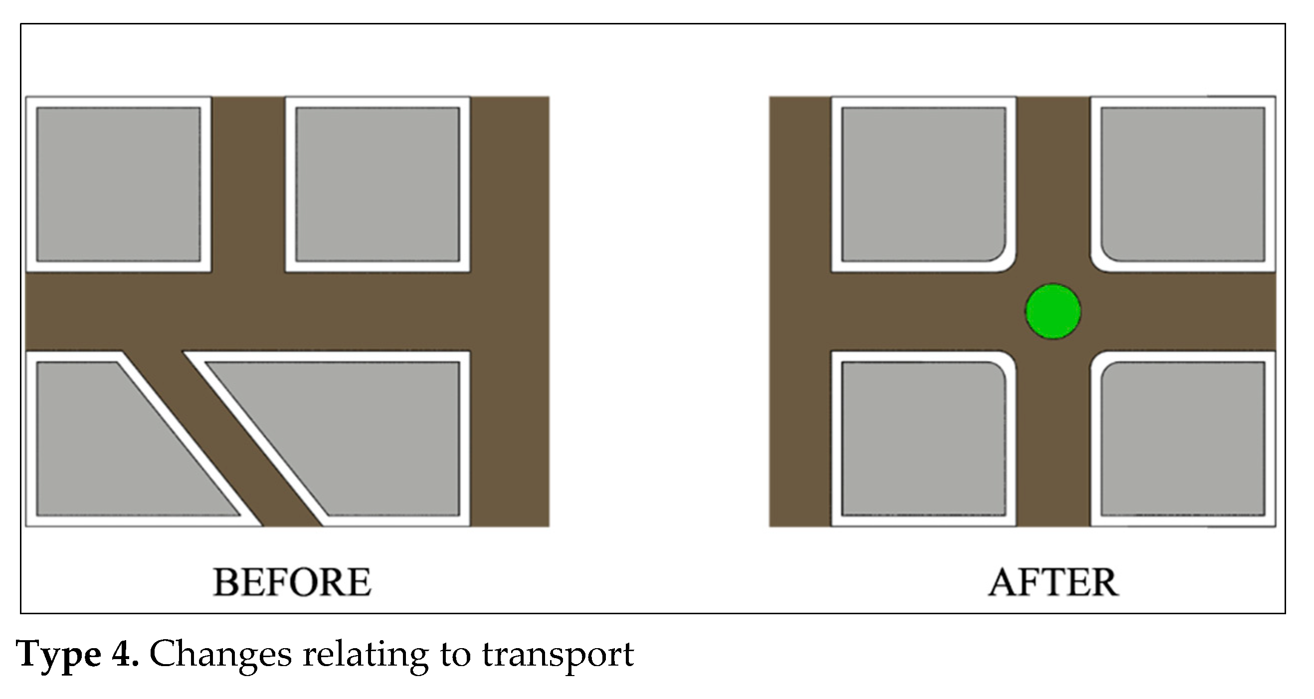
| TYPE 4 | Changes Relating to Transport | 985 (5.6%) |
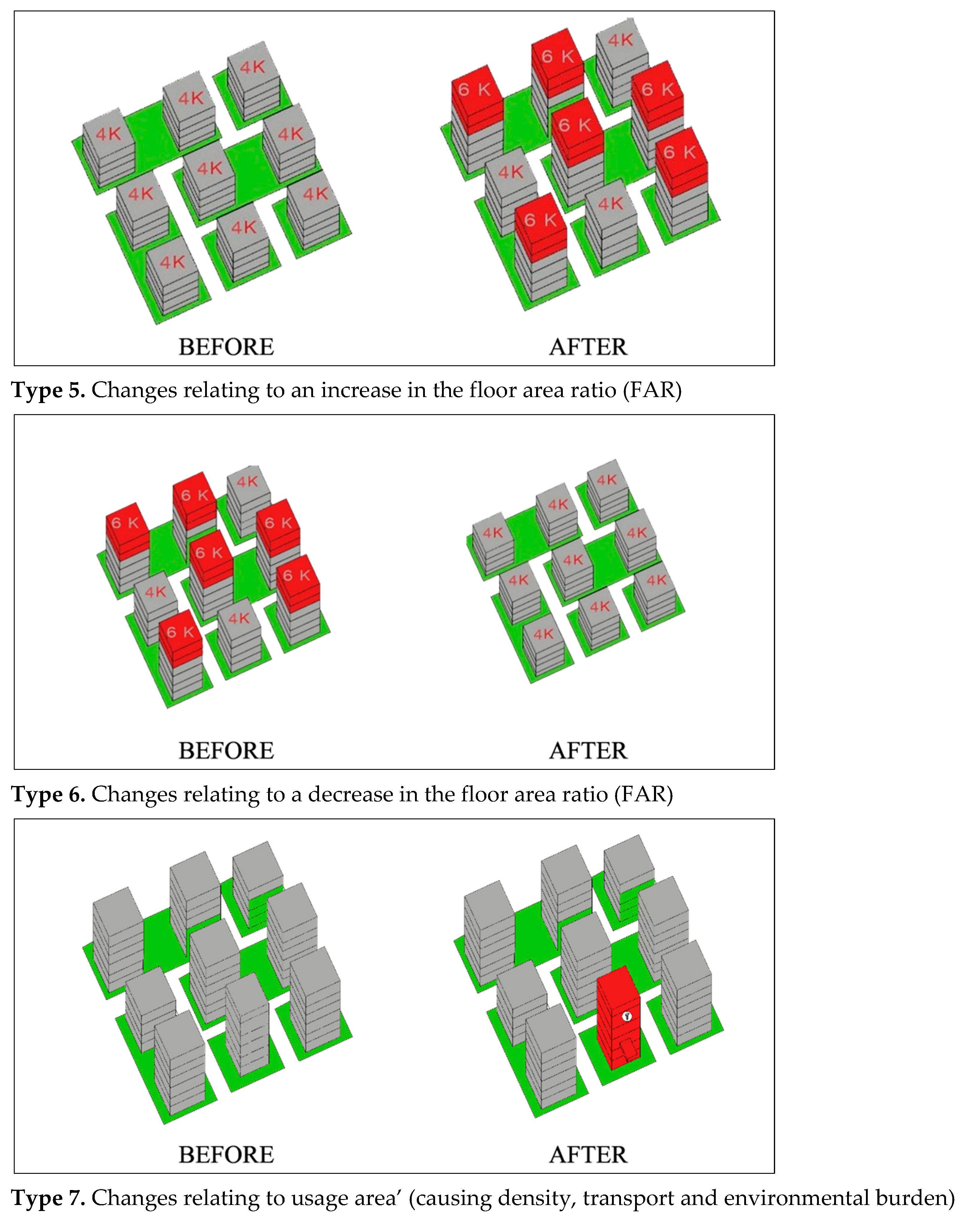
| TYPE 5 | Changes Relating to an Increase in the Floor Area Ratio (FAR) | 2877 (16.6%) |
| TYPE 6 | Changes Relating to a Decrease in the Floor Area Ratio (FAR) | 57 (0.3%) |
| TYPE 7 | Changes Relating to Usage Area’ (Causing Density, Transport and Environmental Burden) | 1714 (9.9%) |
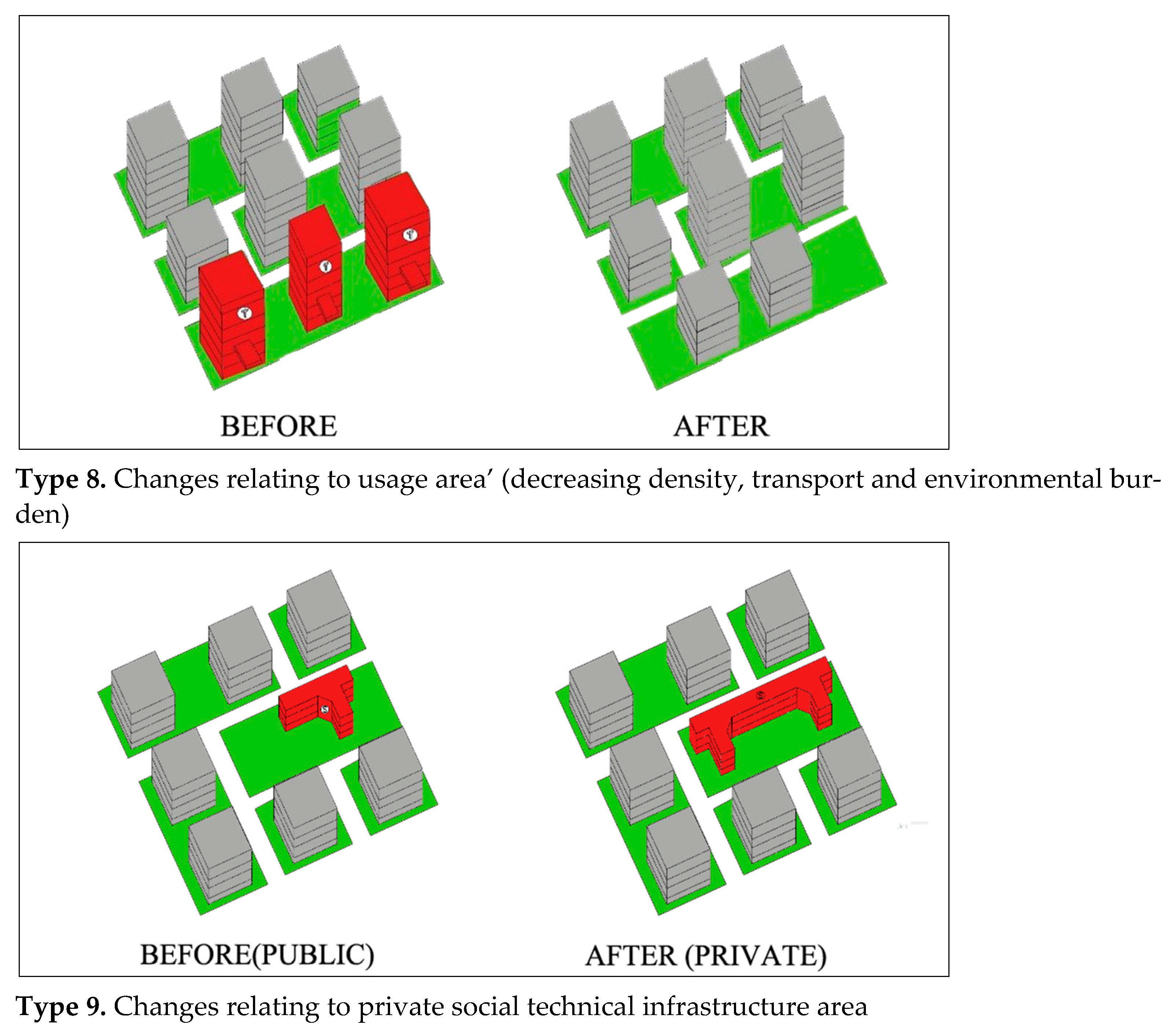
| TYPE 8 | Changes Relating to Usage Area’ (Decreasing Density, Transport and Environmental Burden) | 154 (0.8%) |
| TYPE 9 | Changes Relating to Private Social Technical Infrastructure Area | 853 (5.0%) |
| Total that taken in the analysis | 15,397 (88.6%) | |
| TYPE 10 | Changes Relating to Plan Implementation Practices | 866 (5.0%) |
| TYPE 11 | Error Correction | 429 (2.5%) |
| TYPE 12 | Off-topic Changes | 677 (3.9%) |
| General Total | 17,369 (100%) |
| Interviews | Type 1 | Type 2 | Type 3 | Type 4 | Type 5 | Type 6 | Type 7 | Type 8 | Type 9 | Interviews | Type 1 | Type 2 | Type 3 | Type 4 | Type 5 | Type 6 | Type 7 | Type 8 | Type 9 |
|---|---|---|---|---|---|---|---|---|---|---|---|---|---|---|---|---|---|---|---|
| Interview-1 | 0 | +1 | −1 | +1 | +1 | −1 | +1 | 0 | +1 | Interview-24 | +1 | +1 | −1 | 0 | +1 | −1 | +1 | −1 | +1 |
| Interview-2 | 0 | +1 | −1 | 0 | +1 | −1 | +1 | −1 | +1 | Interview-25 | 0 | +1 | −1 | 0 | +1 | −1 | +1 | −1 | +1 |
| Interview-3 | 0 | +1 | −1 | 0 | +1 | −1 | +1 | −1 | +1 | Interview-26 | 0 | +1 | 0 | +1 | +1 | −1 | 0 | −1 | +1 |
| Interview-4 | 0 | +1 | −1 | +1 | +1 | −1 | +1 | −1 | +1 | Interview-27 | 0 | +1 | −1 | 0 | +1 | −1 | +1 | −1 | +1 |
| Interview-5 | 0 | +1 | −1 | +1 | +1 | −1 | +1 | −1 | +1 | Interview-28 | +1 | +1 | −1 | 0 | +1 | −1 | +1 | −1 | +1 |
| Interview-6 | 0 | +1 | −1 | 0 | +1 | −1 | +1 | −1 | +1 | Interview-29 | +1 | +1 | 0 | +1 | +1 | −1 | 0 | 0 | +1 |
| Interview-7 | 0 | +1 | −1 | +1 | +1 | −1 | +1 | −1 | +1 | Interview-30 | +1 | +1 | −1 | 0 | +1 | 0 | +1 | −1 | +1 |
| Interview-8 | 0 | +1 | −1 | 0 | +1 | −1 | +1 | −1 | +1 | Interview-31 | 0 | +1 | −1 | +1 | +1 | −1 | +1 | −1 | 0 |
| Interview-9 | 0 | +1 | −1 | +1 | +1 | −1 | +1 | −1 | +1 | Interview-32 | 0 | +1 | 0 | +1 | +1 | −1 | +1 | −1 | +1 |
| Interview-10 | +1 | +1 | 0 | 0 | +1 | −1 | +1 | −1 | +1 | Interview-33 | +1 | +1 | −1 | +1 | +1 | −1 | +1 | −1 | +1 |
| Interview-11 | 0 | 0 | −1 | 0 | +1 | −1 | +1 | −1 | +1 | Interview-34 | 0 | +1 | −1 | 0 | +1 | −1 | +1 | −1 | +1 |
| Interview-12 | 0 | 0 | −1 | 0 | +1 | −1 | +1 | −1 | +1 | Interview-35 | +1 | +1 | −1 | +1 | +1 | −1 | +1 | −1 | +1 |
| Interview-13 | +1 | +1 | −1 | 0 | +1 | −1 | +1 | 0 | +1 | Interview-36 | +1 | +1 | 0 | +1 | +1 | −1 | +1 | −1 | +1 |
| Interview-14 | 0 | +1 | 0 | 0 | +1 | −1 | +1 | −1 | 0 | Interview-37 | 0 | +1 | 0 | 0 | +1 | −1 | +1 | −1 | +1 |
| Interview-15 | +1 | +1 | −1 | +1 | +1 | −1 | +1 | −1 | +1 | Interview-38 | +1 | +1 | 0 | +1 | +1 | −1 | +1 | −1 | +1 |
| Interview-16 | 0 | +1 | −1 | 0 | +1 | −1 | +1 | −1 | +1 | Interview-39 | +1 | +1 | −1 | 0 | +1 | −1 | +1 | 1 | +1 |
| Interview-17 | +1 | +1 | −1 | +1 | +1 | −1 | +1 | −1 | +1 | Interview-40 | 0 | +1 | 0 | +1 | +1 | −1 | +1 | −1 | 0 |
| Interview-18 | 0 | +1 | 0 | 0 | +1 | −1 | +1 | 0 | 0 | Interview-41 | 0 | +1 | 0 | 0 | +1 | −1 | +1 | −1 | 0 |
| Interview-19 | 0 | +1 | −1 | 0 | +1 | −1 | 0 | 0 | +1 | Interview-42 | +1 | +1 | −1 | 0 | +1 | −1 | +1 | −1 | +1 |
| Interview-20 | +1 | +1 | −1 | +1 | +1 | −1 | +1 | −1 | +1 | Interview-43 | +1 | +1 | −1 | +1 | +1 | −1 | +1 | −1 | +1 |
| Interview-21 | 0 | +1 | −1 | +1 | +1 | 0 | +1 | −1 | +1 | Interview-44 | 0 | +1 | −1 | +1 | +1 | −1 | +1 | −1 | +1 |
| Interview-22 | 0 | +1 | −1 | +1 | +1 | −1 | +1 | −1 | 0 | Interview-45 | +1 | +1 | 0 | 0 | +1 | 0 | +1 | 0 | +1 |
| Interview-23 | +1 | +1 | −1 | 0 | +1 | −1 | +1 | −1 | 0 | Interview-46 | +1 | +1 | −1 | +1 | +1 | −1 | +1 | −1 | +1 |
| Avarage | 0.26 | 0.91 | −0.9 | 0.43 | +1 | −0.96 | 0.96 | −0.83 | 0.83 | 0.57 | +1 | −0.6 | 0.52 | +1 | −0.9 | 0.91 | −0.83 | 0.87 |
| Interviews | Type 1 | Type 2 | Type 3 | Type 4 | Type 5 | Type 6 | Type 7 | Type 8 | Type 9 | Interviews | Type 1 | Type 2 | Type 3 | Type 4 | Type 5 | Type 6 | Type 7 | Type 8 | Type 9 |
|---|---|---|---|---|---|---|---|---|---|---|---|---|---|---|---|---|---|---|---|
| Interview-1 | 1 | 5 | 0 | 4 | 5 | 0 | 5 | 0 | 5 | Interview-24 | 2 | 5 | 1 | 2 | 5 | 0 | 5 | 0 | 5 |
| Interview-2 | 0 | 5 | 0 | 1 | 5 | 0 | 5 | 1 | 5 | Interview-25 | 1 | 5 | 0 | 1 | 5 | 1 | 4 | 0 | 4 |
| Interview-3 | 2 | 4 | 0 | 1 | 5 | 0 | 5 | 0 | 5 | Interview-26 | 1 | 5 | 0 | 2 | 5 | 0 | 5 | 0 | 5 |
| Interview-4 | 1 | 5 | 0 | 3 | 5 | 0 | 5 | 0 | 5 | Interview-27 | 2 | 5 | 1 | 3 | 5 | 0 | 5 | 0 | 5 |
| Interview-5 | 1 | 5 | 1 | 3 | 5 | 0 | 5 | 0 | 5 | Interview-28 | 1 | 5 | 0 | 1 | 5 | 1 | 5 | 1 | 5 |
| Interview-6 | 2 | 4 | 0 | 2 | 5 | 0 | 5 | 0 | 5 | Interview-29 | 3 | 5 | 0 | 4 | 5 | 0 | 4 | 0 | 3 |
| Interview-7 | 4 | 5 | 0 | 4 | 5 | 0 | 4 | 1 | 5 | Interview-30 | 1 | 5 | 0 | 1 | 5 | 0 | 5 | 0 | 5 |
| Interview-8 | 1 | 5 | 0 | 1 | 5 | 0 | 5 | 0 | 4 | Interview-31 | 0 | 5 | 0 | 3 | 5 | 0 | 5 | 0 | 5 |
| Interview-9 | 3 | 5 | 0 | 4 | 5 | 0 | 5 | 0 | 5 | Interview-32 | 1 | 5 | 0 | 4 | 5 | 0 | 5 | 0 | 5 |
| Interview-10 | 1 | 5 | 0 | 2 | 5 | 0 | 5 | 0 | 5 | Interview-33 | 3 | 5 | 0 | 3 | 5 | 0 | 5 | 0 | 5 |
| Interview-11 | 1 | 5 | 0 | 1 | 5 | 0 | 5 | 0 | 5 | Interview-34 | 1 | 5 | 0 | 1 | 5 | 0 | 5 | 0 | 5 |
| Interview-12 | 3 | 5 | 0 | 4 | 5 | 0 | 5 | 1 | 5 | Interview-35 | 1 | 5 | 2 | 3 | 5 | 1 | 5 | 0 | 4 |
| Interview-13 | 1 | 5 | 0 | 2 | 5 | 0 | 3 | 0 | 5 | Interview-36 | 1 | 5 | 0 | 4 | 5 | 0 | 5 | 0 | 5 |
| Interview-14 | 4 | 4 | 0 | 3 | 5 | 0 | 5 | 0 | 4 | Interview-37 | 2 | 5 | 0 | 1 | 5 | 0 | 5 | 0 | 5 |
| Interview-15 | 2 | 5 | 0 | 1 | 5 | 0 | 5 | 0 | 5 | Interview-38 | 1 | 5 | 1 | 3 | 5 | 1 | 5 | 0 | 5 |
| Interview-16 | 0 | 5 | 0 | 2 | 5 | 0 | 5 | 0 | 5 | Interview-39 | 1 | 5 | 0 | 1 | 5 | 0 | 4 | 0 | 5 |
| Interview-17 | 4 | 5 | 0 | 2 | 5 | 0 | 5 | 0 | 3 | Interview-40 | 3 | 5 | 0 | 4 | 5 | 1 | 4 | 1 | 4 |
| Interview-18 | 1 | 5 | 1 | 3 | 5 | 1 | 4 | 1 | 5 | Interview-41 | 2 | 5 | 1 | 1 | 5 | 0 | 5 | 0 | 5 |
| Interview-19 | 0 | 5 | 0 | 3 | 5 | 0 | 5 | 0 | 4 | Interview-42 | 1 | 5 | 0 | 1 | 5 | 1 | 5 | 0 | 4 |
| Interview-20 | 3 | 5 | 0 | 4 | 5 | 0 | 5 | 0 | 5 | Interview-43 | 1 | 5 | 0 | 4 | 5 | 0 | 5 | 0 | 5 |
| Interview-21 | 3 | 5 | 0 | 2 | 5 | 1 | 3 | 0 | 4 | Interview-44 | 3 | 5 | 2 | 4 | 5 | 0 | 5 | 1 | 5 |
| Interview-22 | 4 | 5 | 1 | 3 | 5 | 0 | 5 | 1 | 5 | Interview-45 | 1 | 5 | 0 | 1 | 5 | 1 | 5 | 0 | 4 |
| Interview-23 | 1 | 5 | 0 | 2 | 5 | 0 | 5 | 0 | 4 | Interview-46 | 1 | 5 | 0 | 3 | 5 | 0 | 5 | 1 | 5 |
| Avarage | 1.09 | 4.87 | 0.13 | 1.87 | 5 | 0.09 | 4.87 | 0.13 | 4.78 | 1.48 | 5 | 0.35 | 1.87 | 5 | 0.3 | 4.91 | 0.17 | 4.7 |
Publisher’s Note: MDPI stays neutral with regard to jurisdictional claims in published maps and institutional affiliations. |
© 2021 by the authors. Licensee MDPI, Basel, Switzerland. This article is an open access article distributed under the terms and conditions of the Creative Commons Attribution (CC BY) license (https://creativecommons.org/licenses/by/4.0/).
Share and Cite
Kılınc, N.; Turk, S.S. Examination of Local Plan Changes from a Value Capture Perspective: Istanbul Case. Sustainability 2022, 14, 329. https://doi.org/10.3390/su14010329
Kılınc N, Turk SS. Examination of Local Plan Changes from a Value Capture Perspective: Istanbul Case. Sustainability. 2022; 14(1):329. https://doi.org/10.3390/su14010329
Chicago/Turabian StyleKılınc, Numan, and Sevkiye Sence Turk. 2022. "Examination of Local Plan Changes from a Value Capture Perspective: Istanbul Case" Sustainability 14, no. 1: 329. https://doi.org/10.3390/su14010329