Article

Analysis on Stability of Roadside Parking System in a Rail-Integrated Transport Hub

1
School of Civil Engineering, Guangzhou University, Guangzhou 510006, China
2
Guangzhou Urban Planning & Design Survey Research Institute, Guangzhou 510006, China
*
Author to whom correspondence should be addressed.
Sustainability 2021, 13(9), 4855; https://doi.org/10.3390/su13094855
Submission received: 25 March 2021 / Revised: 20 April 2021 / Accepted: 21 April 2021 / Published: 26 April 2021

Abstract

:
Roadside parking systems plays an important role in the planning and design of parking spaces, parking management and operation, and ensuring the safety of passengers. Firstly, we proposed a traffic wave theory and an avoidance logic algorithm to analyze the interaction mechanism of the roadside parking system in a rail-integrated transport hub. Moreover, we researched the evaluation indexes of the stability of roadside parking systems via two new concepts, namely static roadside parking time and dynamic roadside parking time. We found these improved the algorithm of the time utilization rate of the berth. Secondly, the coupling relationship between parking rate, delay and time utilization of berth was also discussed, and mathematical models of stability of the curb parking system were established. Furthermore, the feasibility of models was verified by multi-agent simulation through the VISSIM simulation platform. Finally, a new rail-integrated transport hub was taken as a practical case and studied alongside the simulation of the stability of curb parking system. Our study concluded that the curb parking system was ultimate stable when the time utilization rate was 37.5% and the parking rate was 91.2%. The results of these studies will provide theoretical support for designing curb parking berths in rail-integrated transport hubs.

1. Introduction

A rail-integrated transport hub is a key component of the transportation system in China and is an important transportation node for residents in long-distance traveling [1]. Generally, temporary parking is provided on both sides of the roads in the rail-integrated transport hub for the convenience of tourists in cars. However, parking spaces in the roads of rail-integrated transport hub differ from those in the roads of the general cities in terms of short parking times; temporary parking time in an urban environment is longer than in the rail-integrated transport hub (less than 3 min), and its traffic environment is simpler than a rail-integrated transport hub. With frequent vehicle arrivals and departures, strong mutual interference between vehicles, and serious interference between people and vehicles were caused by tourists carrying large luggage and moving relatively slowly. These situations can lead to road traffic jams. Therefore, conducting research on the roadside parking system of rail-integrated transport hubs is crucial.
Currently, most research on roadside parking systems by scholars focuses on the influence of roadside parking on urban road traffic, and the charge management and control of roadside parking. According to a multi-agent simulation model, Leclercq et al. [2] studied a transportation characteristic model of different vehicle types by establishing the said model on roadside parking regions. Arnott et al. [3] developed an evolution model of parking rates with parking occupancy rates by comprehensively considering the drivers’ parking charge and parking time. Cao et al. [4] examined the relationship of the parking numbers with the management strategy on the parking duration. Geroliminis et al. [5] and Nan et al. [6] explored the relationship between parking costs and parking pricing in a congested road based on the Macroscopic Fundamental Diagram (MFD) model. Du et al. [7] established mathematical programs with an equilibrium constraints (MPEC) model to reduce vehicle delay through the configuration optimization of parking numbers. Hunt [8] conducted modeling analysis on roadside parking methods and locations through a logit model, with research results applied to the policy of assessing the choice of roadside parking methods by Bradley [9]. Kobus et al. [10] analyzed the influence of roadside parking on the parking charges through the probit model. Boyles et al. [11] based on the influence of parking duration on berth utilization rate and the influence of roadside berth search on road traffic volume, The relationship between parking duration and search distance and time is quantified. Millard-Ball et al. [12] studied the relationship model between the parking utilization rate and the probability of finding a berth and the number of cruises, then put forward the plan to control the optimal berth utilization rate and reduce the traffic delay.
Furthermore, many scholars use the prediction of parking demands and the interactive mechanism model to analyze roadside parking systems. Pei et al. [13] studied a block model of roadside parking through queuing theory and traffic wave theory. Zhao et al. [14] and Zhang et al. [15] based on the network of roadside parking system, the prediction method of a wide range of roadside berth utilization under dynamic management model was studied, and a dynamic roadside berth supply scheme with coordinated parking demand and space-time balance of parking resources was constructed. Liu et al. [16] and Wei et al. [17] investigated the relationship between the probability of vehicle lane changing, the stopping–waiting probability, and traffic jam probability through the cellular automata model. Yu et al. [18] studied the design of parking lot management system according to Advanced RISC Machine (ARM) system. Yin et al. [19] and Zhang et al. [20] examined the influencing factors of parking demand and parking selection behavior in urban centers and established a parking charging structure model. Wang et al. [21], based on the study of the game model of roadside parking charges, modified the parking charges of private cars, and the multi-mode travel network distribution model was established, which was subject to the Logit function. Li et al. [22] and Cao et al. [23] established a modified model on the influencing coefficient of parking demand prediction with a single architecture function and a Logit model for forecasting parking demand in the central and peripheral areas of a city.
The above literature analysis indicates that research on parking theory by scholars has achieved numerous results, and the research methods mainly focus on roadside parking systems. However, the internal interactive mechanism of the parking system has not been deeply investigated. The internal interactive mechanism of the roadside parking system is the result of the interactions between vehicles, people and roads. It is an important node to analyze the operating mechanism of the roadside parking system and a necessary condition to analyze and model the roadside parking system. However, due to the short temporary parking time of rail-integrated transport hubs, the serious mixing of people and vehicles, and the numerous factors affecting the roadside parking system, it is difficult to carry out quantitative analysis and evaluation; thus, scarce analysis is conducted on the interaction between parking vehicles and the traffic environment within the system. Moreover, research on the stability of a roadside parking system in a rail-integrated transport hub is insufficient.
This work examines the stability of a parking system through the complex adaptive system theory with the roadside parking system in a rail-integrated transport hub as the research object. Furthermore, the interactive mechanism of an internal parking system is examined according to basic traffic wave theory and the avoidance logic algorithm. The stability of a roadside parking system in a rail-integrated transport hub is also analyzed through simulation tests, the investigation and evaluation of traffic data, research on the specific evaluation indicators, and the establishment of an analytical model of the stability of the roadside parking system.

2. Research on the Basic Theory of Roadside Parking System

2.1. Research on the Stability Strategy of a Roadside Parking System

In 1992, complex adaptive system theories were developed by Holland [24], whose basic idea presents the following three aspects. (1) A certain number of agents exist in the system. General systems, simple systems, non-organized complex systems and organized complex systems can be classified according to the number of individuals in the system and the intensity of interaction. (2) Agents are active and adaptable. Agents were follow specific rules in the system, adjusting their behavior and state according to environmental information, and generating new rules. Through the relatively low active behavior of the agent, the system as a whole shows a higher level, more complex, more coordinated functions of order. (3) The agents can receive local information without central control. In complex systems, no agent is fully aware of the state and behavior of all other entities; each agent can only get information from a relatively small set of individuals, process “local information”, and make corresponding decisions. The whole behavior of the system emerges through local interactions such as competition and cooperation among individuals.
The roadside parking system of a rail-integrated transport hub is judged according to the features of the complex adaptive system: (1) The number of agents. Agents of parking vehicles and pedestrian transfer exist in the roadside parking system of a rail-integrated transport hub. The number of agents meets the requirements of complex adaptive systems. (2) Agent intelligence and adaptability. In a roadside parking system, the driver shows a clear purpose, which is expressed explicitly as searching for a parking space on the roadside. In accomplishing the goal, the driver makes corresponding decisions by receiving information from the traffic environment (such as avoiding other vehicles and transferring pedestrians) and adjusts his/her own behavior. (3) Local information. Given the complexity of the traffic environment of a roadside parking system, drivers cannot be fully aware of other drivers and surrounding environments; they can only make decisions according to the current ongoing conditions and local environment. Thus, the roadside parking system of a rail-integrated transport hub conforms to the complex adaptive system.
Multi-agent simulation modeling is generally adopted in the modeling of a roadside parking complex adaptive system theory, and the modeling method is characterized by flexibility, hierarchy, and intuitiveness [25]. Multi-agents such as drivers and pedestrians can be found in the system. Drivers can adjust their own behaviors according to the local information. The primary system interacts with the basic rules and produces the result of the interaction. Furthermore, a more advanced and orderly system is produced through the interaction between vehicle agents and the road environment, vehicle agents and pedestrians, vehicle agents and each other. Roadside parking rate, parking time utilization and parking delays are the interactive results of the roadside parking system, and are also important indexes to evaluate the stability of the system. The internal interaction will reach a balance to achieve the ultimate stability of the system. When the balance is exceeded, the advanced system collapses and automatically adjusts to the primary system. Therefore, the limit equilibrium state of the interactive result can be used to evaluate the stability of the roadside parking system (Figure 1).

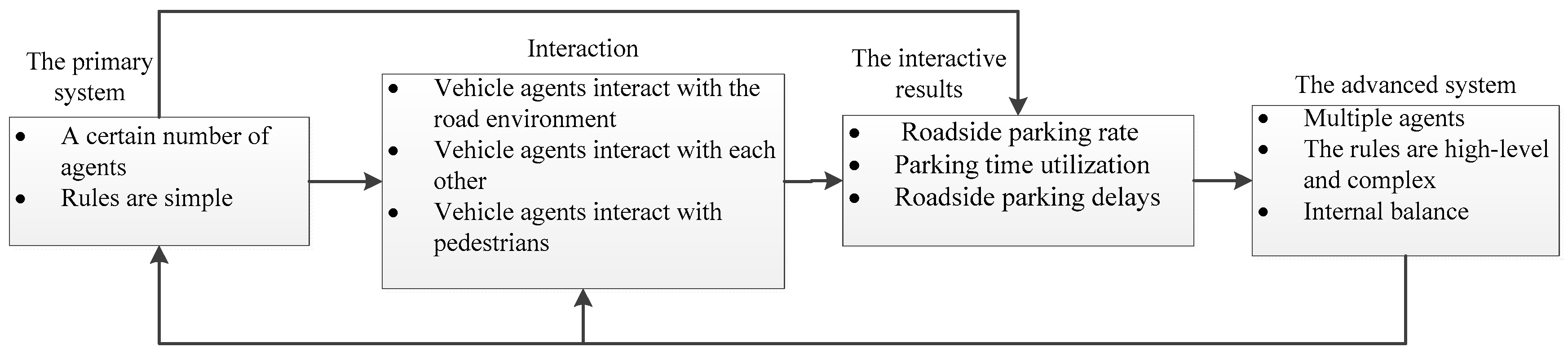
2.2. Research on the Interactive Mechanism of a Roadside Parking System

Traffic wave theory is an effective method to analyze the temporal and spatial characteristics of road traffic flow. Nowadays, the theory of traffic waves is often used in the analysis of traffic accident detection [26,27], and the analysis of traffic congestion and parking delays [28,29]. In the roadside parking system of a rail-integrated transportation hub, vehicle arrival is continuous and is interactively influenced by the roadside parking system for vehicles going in and out of parking spaces [30]. Therefore, according to the continuity of vehicle arrival, the operation of a parking system is simulated through traffic wave theory to examine further the mechanism of parking vehicle interaction [31].
Assuming that the speed is V 1 , the traffic volume is Q 1 and the density is μ 1 when the traffic flow enters the parking system normally. When traffic flow enters the parking system, a build-up wave is formed under the influence of the vehicles inside the system, and the traffic wave speed is V j . At this time, the traffic flow speed is V 2 , the traffic volume is Q 2 , and the density is μ 2 . When the traffic flow goes out of the parking system, a rarefaction wave is formed and the traffic wave speed is V e . At this time, the traffic flow speed is V 3 , the traffic volume is Q 3 and the density is μ 3 . According to the traffic wave theory, the traffic flow wave speed is shown in Equations (1) and (2):
V j = Q 1 Q 2 μ 1 μ 2
V e = Q 2 Q 3 μ 2 μ 3
Thus, the maximum number of congested vehicles in the parking system is N max = μ 2 ( V 2 V j 1 ) t 2 within t 2 . Therefore, at t , the number of disturbed vehicles in the parking system is N ( t ) = N max / t 2 ,   0 t t 2 . When Δ t is minimal, the delay of vehicles N ( t ) is Δ D = N ( t ) Δ t ( 1 V 2 V 1 ) within ( t , t + Δ t ) . Consequently, the delay within ( 0 , t 2 ) , the delay within ( ( n 1 ) t 2 , n t 2 ) , and the total delay within the total time period t l can be obtained as shown in Equations (3)–(5):
D 1 = 0 t 2 N ( t ) ( 1 V 2 V 1 ) d t = ( 1 2 V 2 1 2 V j ) μ 2 t 2 2 ( 1 V 2 V 1 )
D n = ( V 2 2 n 1 2 V j ) μ 2 t 2 2 ( 1 V 2 V 1 )
D = ( 1 V 2 V 1 ) μ 2 t 2 2 [ ( t l t 2 1 2 ) V 2 1 2 ( t l t 2 ) 2 V j ]
The delay of the roadside parking system can be quantitatively analyzed, and the internal interaction mechanism of the roadside parking foundation can be deeply studied through the delay model. The research conclusions show that parking delay is linearly related to the density of traffic flow and traffic volume, and this finding provides a theoretical basis for the subsequent establishment of roadside parking models.

2.3. Research on the Avoidance Logic Algorithm of a Roadside Parking System

“BOIDS” is equivalent to the abbreviation of bird-oid objects, referring to bird-like objects. It is a computer model that simulates the cooperative behavior of animal groups such as fish and birds, which was made by Craig Reynolds [32,33] in 1986. BOIDS is a control algorithm that describes the autonomous role turning behavior of agents and the swarm behavior of agents. One of the BOIDS is equivalent to an agent that is aware of its environment, each of which follows a simple set of rules and is able to perform autonomous steering, or control its own behavior [34].
Given the complex traffic environment in a roadside parking system, the methods of parking vehicles in avoiding other vehicles and obstacles are crucial to constructing the simulation model. The BOIDS algorithm can effectively describe the interaction behavior of a multi-intelligence model with the environment. In a complex adaptive system, the BOIDS algorithm can turn autonomously and effectively avoid other obstacles. To explain the behavior of roadside parking vehicles avoiding other vehicles and obstacles, the improved-BOIDS algorithm is redesigned as follows:
(1) Setting the avoidance areas for roadside parking vehicles. V f i r s t is the ongoing direction of the vehicle, G h e a d is the vehicle safety distance vector whose modulus is defined as R . G h e a d and V f i r s t are in the same direction but in different modes. G d a n g e r is the minimum safe distance for steering and whose modulus is defined as r. G h e a d is parallel to G d a n g e r , and | G d a n g e r | = | G h e a d | / 2 . The vehicle safety distance vector and the minimum safety distance vector are shown in Equations (6) and (7).
G h e a d = V f i r s t | V f i r s t | . | G h e a d | + L b o i d
G d a n g e r = V f i r s t | V f i r s t | . | G h e a d | . 1 2 + L b o i d
where L b o i d is the current position of the parking vehicle. The avoidance steering behavior should be completed between entering the safe distance and the minimum safe distance.
(2) Roadside parking vehicles can predict other vehicles and obstacles. The most threatening other vehicles and obstacles in the roadside parking system are selected for a collision check. The distance between the vehicle and the center of the obstacle d is calculated as shown in Equation (8).
d = ( x b o i d x o b s t a c l e ) 2 + ( x b o i d x o b s t a c l e ) 2
where x b o i d and x o b s t a c l e are the coordinate values of the parking vehicle. x b o i d and x o b s t a c l e are the coordinate values of other vehicles and obstacles. Avoidance behavior occurs when d R < R o b s t a c l e < d r .
(3) The roadside parking vehicle completes the avoidance behavior after the roadside parking vehicle predicts other parking vehicles and obstacles. In order to maintain a safe distance from other vehicles and obstacles, the avoidance force acts on the vehicle to accelerate or decelerate, and completes the avoidance behavior smoothly, as shown in Equation (9).
A voidance   f o r c e = G h e a d o b s t a c l e | G h e a d o b s t a c l e | . max _ A voidance   f o r c e
where max _ A voidance f o r c e is the maximum calibration value for the avoidance force. Where G h e a d o b s t a c l e | G h e a d o b s t a c l e | is the unit vector of the avoidance force, which can be calculated from the vehicle safety distance vector and the vehicle obstacle vector.

2.4. Establishment of a Stability Strategy Model of a Roadside Parking System

2.4.1. Traffic Survey Sample Size Analysis

Data in the roadside parking system model originated from the Guangzhou South Railway Station and Guangzhou East Railway Station, the representative high-speed railway station and the railway station of China’s rail-integrated transport hubs, respectively. Abnormal data and missing data were disposed of in the process of traffic characteristic data processing. We deleted the records with abnormal information. As for the missing data, We used mathematical formulas to conduct statistical analysis on the data, and then fill the data according to the principle of the Bayesian formula.
Moreover, in order to ensure the research accuracy, the method of manual field investigation was adopted to calculate the mean value and standard deviation of the survey data according to the pilot survey data, and then determine the minimum sample size according to the possible allowable error [35,36]. Taking the parking time on the side of a vehicle as an example, the sample size estimation is shown in Equation (10).
n ( t α / 2 S E ) 2
where n is the sample size, and S is the estimated standard deviation of the sample, and S = 30 s according to the empirical data of the pilot survey; The confidence level of 95% is taken t α / 2 = 1.64 ; Where E is the allowable error, this article take E = 3 s, therefore, in order to ensure the accuracy of the sample, The sample size of roadside parking time n 269 . According to the same method, the sample size requirements of other roadside parking characteristics data can be obtained, and the calculation of the minimum sample size and the actual survey sample size are shown in Table 1; the sample size survey of roadside parking characteristics meets the accuracy requirement.

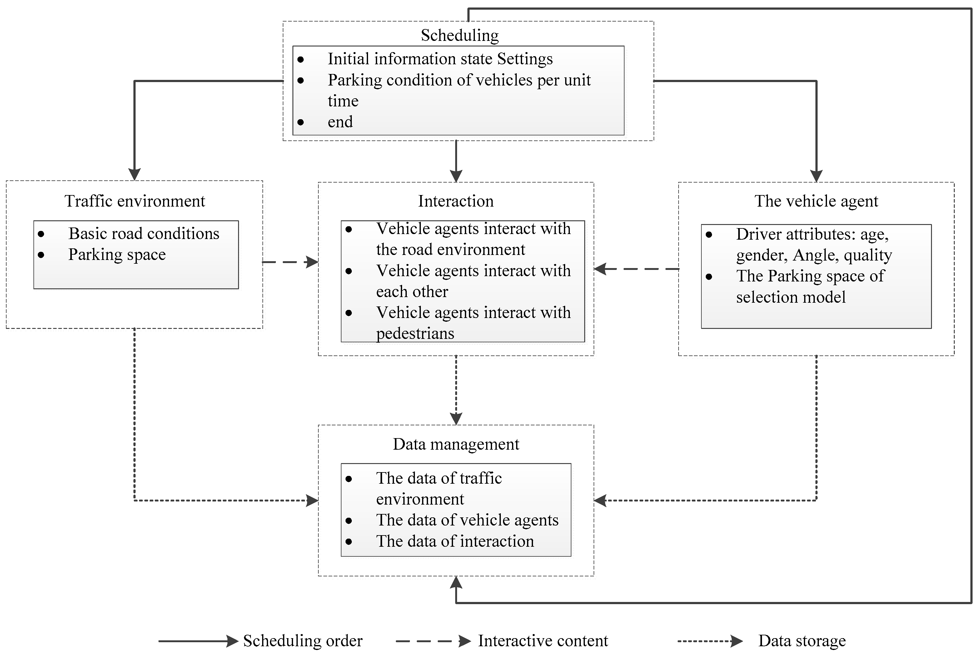
2.4.2. Establishment of a Stability Strategy Model of a Roadside Parking System

The analysis method according to multi-agents is applicable to various fields of roads, railways, aviation, and urban transportation [37]. In 2016, Behe [38] proposed a meta-model based on ontology and believed that a multi-agent simulation model should include at least four parts: agent behavior, environment, scheduling, and interaction. Inspired by Behe, the vehicle agent, traffic environment, scheduling, interaction, and data management modules are set in this article. The logical architecture of the multi-agent simulation model is constructed as shown in Figure 2.
Roadside parking rate, delay, and parking time utilization are important aspects of the interaction of roadside parking systems and are also important indicators for measuring system stability [39,40]. The coupling relationship between the parking time utilization, parking delay, and the parking rate according to the actual investigation data constitute the research focus, thereby establishing the stability model of the roadside parking system.
The roadside time utilization rate–roadside parking delay scattered diagram, and roadside time utilization rate–roadside parking rate scatter diagram are calculated according to the actual measurement data. With the increase of roadside time utilization, roadside parking delay increases gradually. When the roadside time utilization exceeds a certain threshold, parking delay increases rapidly, as shown in Figure 3.
A mathematical model of parking time utilization and parking delay is established on the basis of the fitting results. The curve model is a piecewise function and conforms to the negative exponential function distribution. The fitting function is shown in Equation (11).
D = 41.15 e 0.175 T + 10.81 ,   0   <   T     37.5 % ,   R 2 = 0.93 D = 1.76 e 0.99 T + 10.5 ,   37.5 %   <   T   < + ,   R 2 = 0.98
where D is roadside parking delay, T is roadside parking time utilization.
Analysis of the curve shows that when the parking time utilization rate is below 37.5%, the delay is increased as the growth of the time utilization in that the roadside interference is improved. When the parking time utilization rate exceeds 37.5%, the road is digested, the delay is increased to the positive infinity, and then the roadside parking system collapses.
Similarly, a mathematical model of parking time utilization and parking delay is established according to the fitting results. With the increase of roadside time utilization, roadside parking rate decreases gradually. When the roadside time utilization exceeds a certain threshold, roadside parking rate decreases rapidly, as shown in Figure 4. The curve model conforms to the exponential function distribution. The fitting function is shown in Equation (12).
P = 0.015 e 0.17 T + 99
The deterministic coefficient is R 2 = 0.96. When the parking time utilization is 37.5%, the parking rate can be calculated as 91.2% by substituting parking time utilization into the mathematical model of parking time utilization and delay rate.

3. Research on the Evaluation Indicators of a Roadside Parking System

As the roadside parking system in the rail-integrated transport hub is not the parking lot essentially, but is the temporary parking transfer system, the indicators for evaluating a parking space are inapplicable [41,42]. Therefore, the internal interaction mechanism of a parking system is studied from the perspective of an operating mechanism of the parking system and concepts such as static roadside parking duration, dynamic roadside parking duration, parking rate, parking delay, and parking time utilization are proposed in this paper.

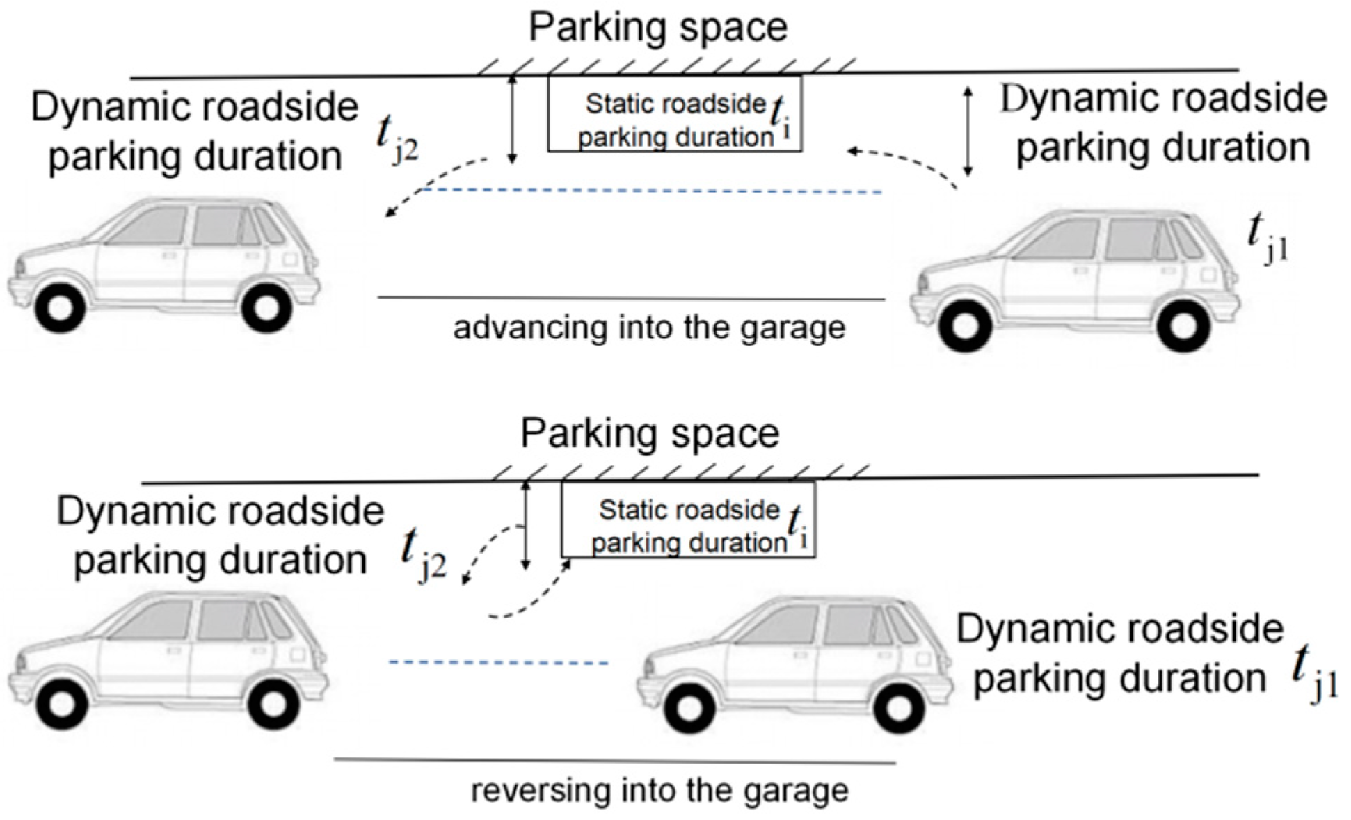
3.1. Static Roadside Parking Duration

Static roadside parking duration is included in this work to reflect the occupancy time of roadside parking on a parking facility. Static roadside parking duration refers to the average parking duration of each vehicle after the vehicle is in a static status, as shown in Equation (13).
t ¯ S = i = 1 n t S i n
where t ¯ S is the static roadside parking duration of the vehicle, t S i is the parking duration of the i vehicle in a static status, and n is the total number of parking times during the working hours. The actual investigation and analysis results indicate that the average static roadside parking duration is 45 s.

3.2. Dynamic Roadside Parking Duration

A longer dynamic roadside parking time leads to stronger roadside vehicle interference [43,44]. Therefore, dynamic roadside parking duration is included in this research to reflect the influence of the interaction between roadside parking and traffic environments on the roadside parking system. The dynamic roadside parking duration or the time lost by the vehicle in the roadside parking movement refers to the time required for the vehicle to enter the parking space and leave the parking space after reaching the expected parking space. In that duration, parking vehicles will affect the vehicles before and after the expected parking space. Two roadside parking modes occur: “reversing into the garage” and “advancing into the garage”, and the process of vehicle parking includes dynamic roadside parking duration and static roadside parking duration (Figure 5). These two types of parking modes are calculated the same way as shown in Equation (14).
t ¯ D = i = 1 n ( t D i 1 + t D i 2 ) n
where, t ¯ D is the dynamic roadside parking duration. t D i 1 is the time required for the i vehicle to enter the parking space, and t D i 2 is the time to leave the parking space.
t D i 1 is generally greater than t D i 2 according to the data analysis. The dynamic roadside parking duration of the “reversing into the garage” and “advancing into the garage” modes are almost the same. The total lost time t ¯ D is regarded as the research object regardless of the parking mode in the successive study to examine the relationship between dynamic parking duration and operation delay and traffic volume.

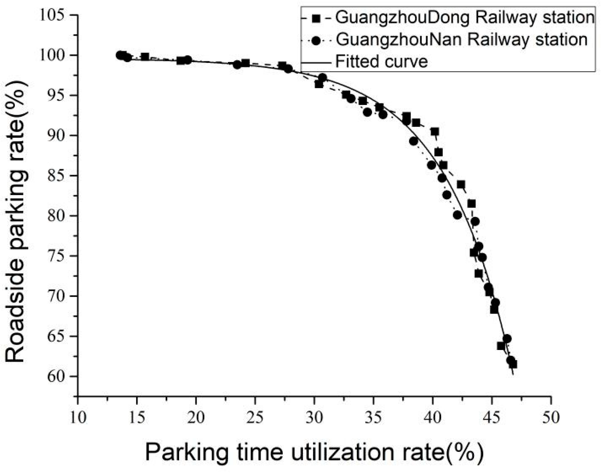
3.3. Roadside Parking Rate

The roadside parking rate (“parking rate” for short) refers to the ratio of the number of effectively parked vehicles to the total number of roadside parking-demanding vehicles during the statistical period [45,46]. The rate is shown in Equation (15). A higher parking rate indicates higher effective utilization rate of the parking space.
P = n N × 100 %
where, P is the roadside parking rate, and n is the number of effectively parked vehicles. N is the total number of roadside parking-demanding vehicles.

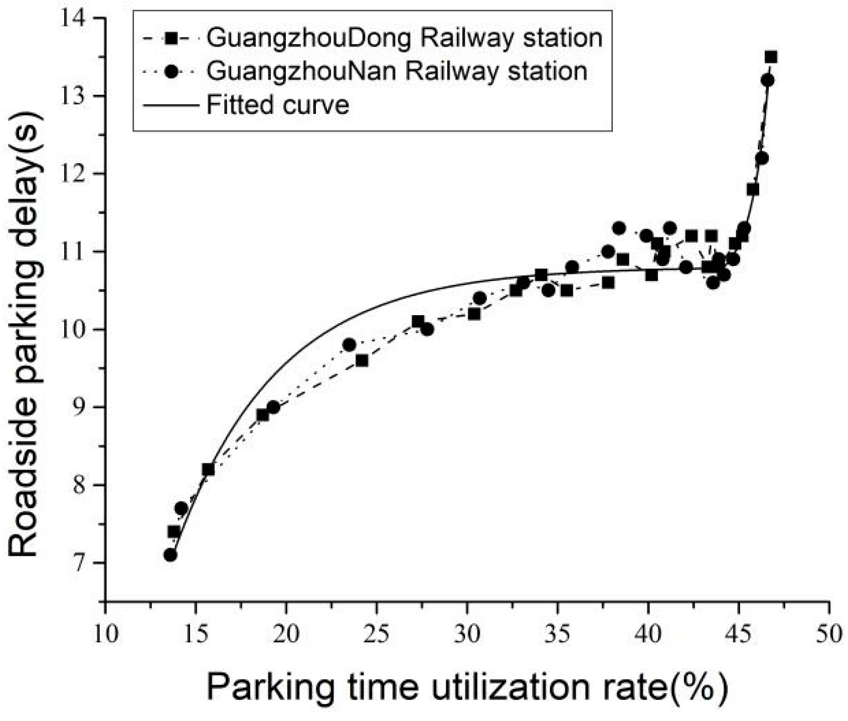
3.4. Roadside Parking Delays

Roadside parking delay refers to the time loss caused by mutual interference between vehicles as well as the interference between pedestrians and vehicles when vehicles pass through the roadside parking area. Roadside parking delay reflects the jam of roadside parking systems at a certain time and is also an important indicator to measure the stability of roadside parking systems. The delay is calculated in the same manner as that shown in Equation (16).
D = T a T b
where D is the roadside parking delays. T a is the actual time required for the parking vehicle to pass through the roadside parking area. Conversely, T b is the ideal time required for the parking vehicle to pass through the roadside parking area.

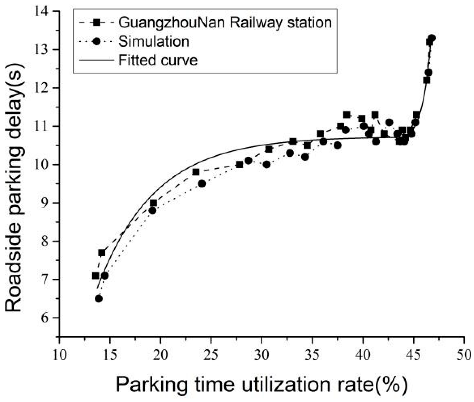
3.5. Parking Time Utilization

The parking time utilization rate of the traditional parking lot is obtained by the total static parking duration dividing the total working time without considering the dynamic parking duration, which is inconsistent with the actual parking situation on the roadside parking of the rail-integrated transport hub [47]. Compared with that in the traditional parking lots, the dynamic parking duration of roadside parking accounts for approximately 50% of the total roadside parking duration. In addition, roadside parking delay caused by the dynamic parking duration is much larger than the parking delay in the parking lot. Therefore, the dynamic parking time is an important indicator that affects roadside parking. Considering the dynamic roadside parking duration, the parking time utilization rate is improved, as shown in Equation (17).
T = i = 1 n ( t S i + t D i ) C S 100 %
where T is the roadside parking time utilization rate. t S i is the static parking duration of the i th vehicle. t D i is the dynamic roadside parking duration of the i vehicle. S is the working hours of the platform roadside parking spaces. As the rail-integrated transport hub is open for 24 h, T is generally taken as 24 h, and C as the number of platform roadside parking spaces.

4. Model Application and Analysis

Given the above research conclusions, the complex adaptive system for roadside parking of the newly-built rail-integrated transport hub in Tangxi, Guangzhou was modeled. Micro-simulation analysis was conducted through the VISSIM simulation platform on the basis of the logical architecture of the multi-agent simulation model. The roadside parking rate and parking delay are taken as evaluation indicators for evaluating and improving the actual plan.

4.1. Analysis of the Stability Boundary of the Roadside Parking System

Data in the roadside parking system model originated from the Guangzhou South Railway Station and Guangzhou East Railway Station, the representative high-speed railway station and the railway station of China’s rail-integrated transport hub, respectively. The research results are of certain popularity and promotion, which will provide a theoretical foundation for the design and operation of other rail-integrated transport hubs.

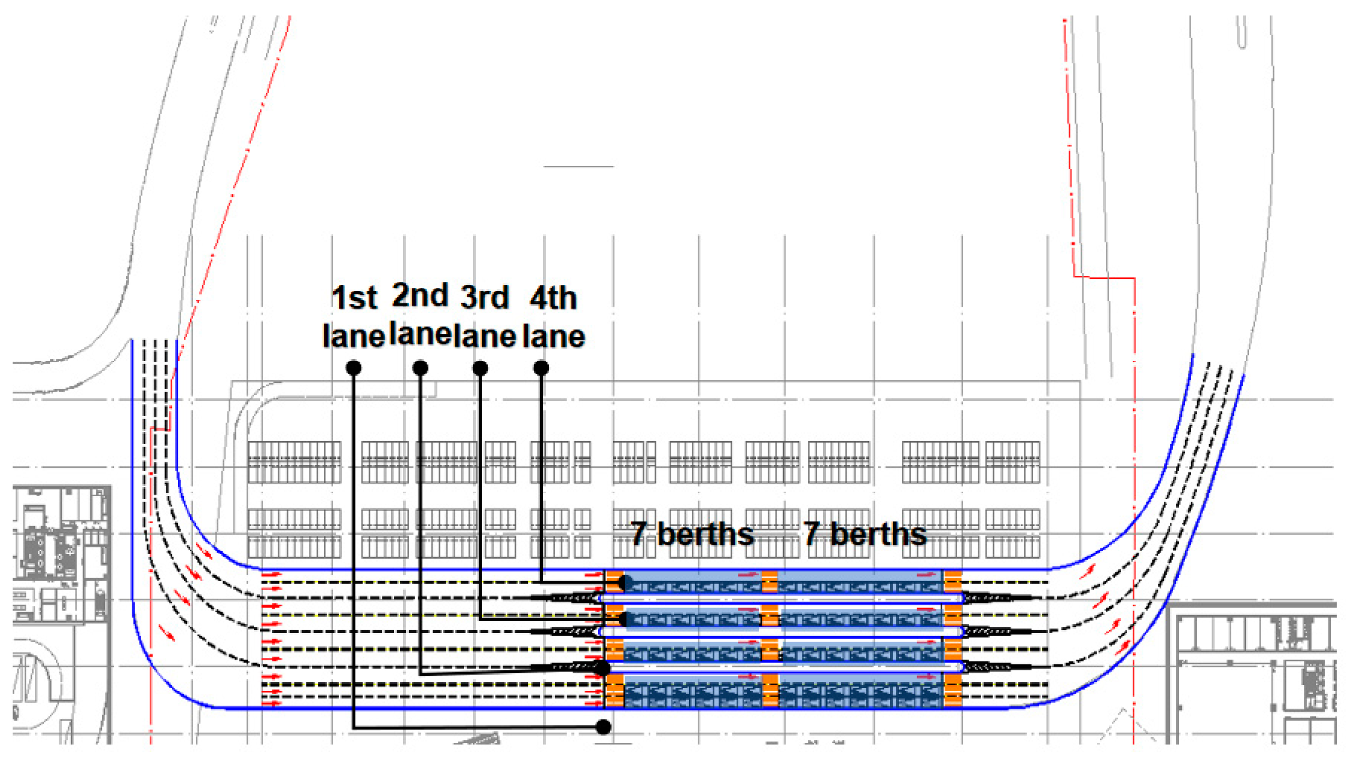
4.2. Construction and Inspection of the Simulation Model of the Roadside Parking System

The Guangzhou South Railway Station is used as a test case to simulate a realistic traffic scene for verifying the correctness of the boundary conditions of the roadside parking model. According to the vehicle avoidance logic algorithm, the relevant parameters are calibrated to check whether the fitted model meets the simulation data analysis result, and error analysis is performed.
According to the multi-agent simulation model logic architecture of the roadside parking complex adaptive system, simulation models of vehicle agents, road environment, and pedestrians are constructed through the VISSIM simulation platform. Multi-agents such as drivers and pedestrians can be found in Figure 6. Drivers can adjust their own behaviors according to the local information, the vehicle agent, traffic environment, scheduling, interaction, and data management modules are set in this model.
Parameters such as delay and parking time utilization are collected and analyzed. The comparison curve between the simulation and the calculation results is obtained. The curve of the actual survey fitting result is consistent with the curve of the simulation result. With the increase of the roadside time utilization rate, the roadside parking delay gradually increases. Parking delays increase rapidly when roadside time utilization exceeds a certain threshold (Figure 7).
The average absolute percentage error is employed to compare and analyze the difference between the simulation and calculation results, as shown in Equation (18):
M = i = 1 n | y c i y s i y c i | × 100 % n
where M is the average absolute percentage error, y c i is the i calculation result of the model, y s i is the i simulation result, and n is the sample number.
The above simulation results indicate that the mathematical model fitting curve of the Guangzhou South Railway Station shows the same trend as the simulation model curve, and both conform to the exponential distribution. The average absolute percentage error of the parking rate and delay is calculated as 1.03% and 3.03%, respectively, by applying Formula (6). Therefore, the quantitative analysis on the stability of the roadside parking system through the relationship of the parking rate, delay, and parking time utilization is reasonable.
Combined with the analysis in Section 2.4.2, it can be concluded that with the increase of parking time utilization rate, roadside parking delays will increase. When the parking time utilization rate is more than 37.5%, the parking delay will rapidly increase to infinity, At this point, it can be determined that the roadside parking system has collapsed, 37.5% of parking time utilization is the threshold of the roadside parking system. According to the analysis of Equations (15) and (16), the roadside parking rate threshold is 91.2%. Thus, when the parking rate is greater than 91.2%, the roadside parking system is operating well. When the parking rate is less than 91.2%, the roadside parking system vehicles will start to queue outside the parking area, and the system tends to be unstable.

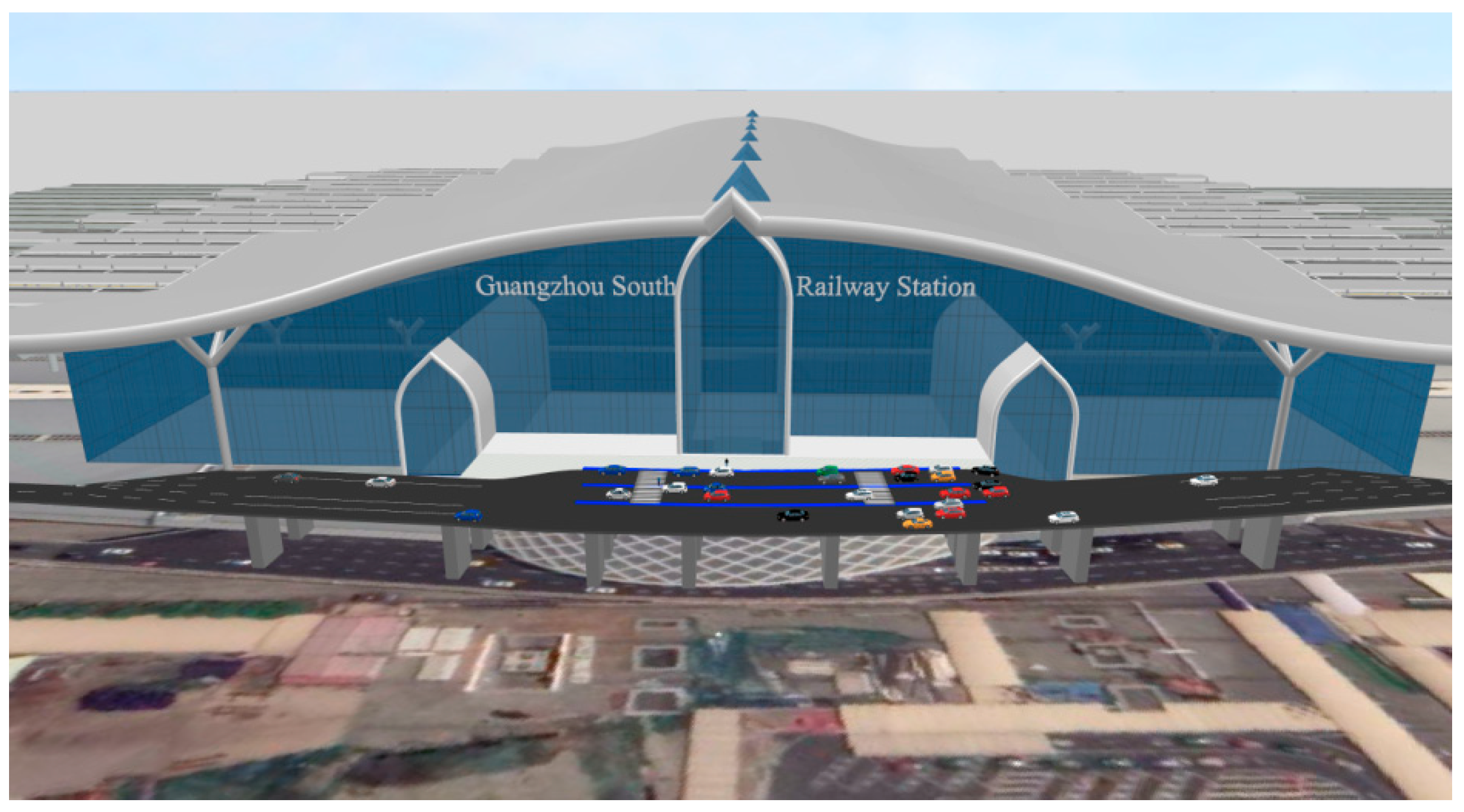
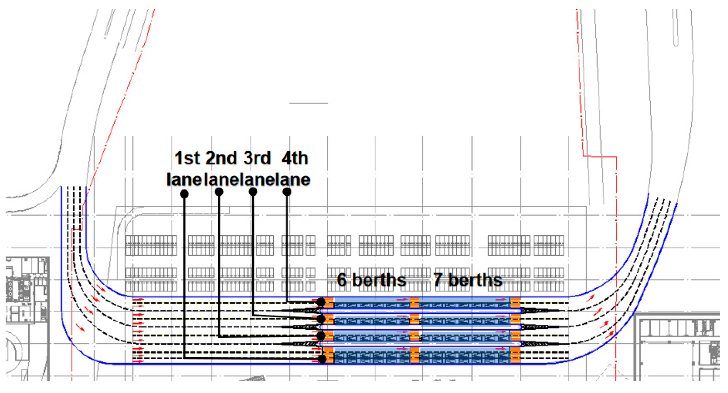
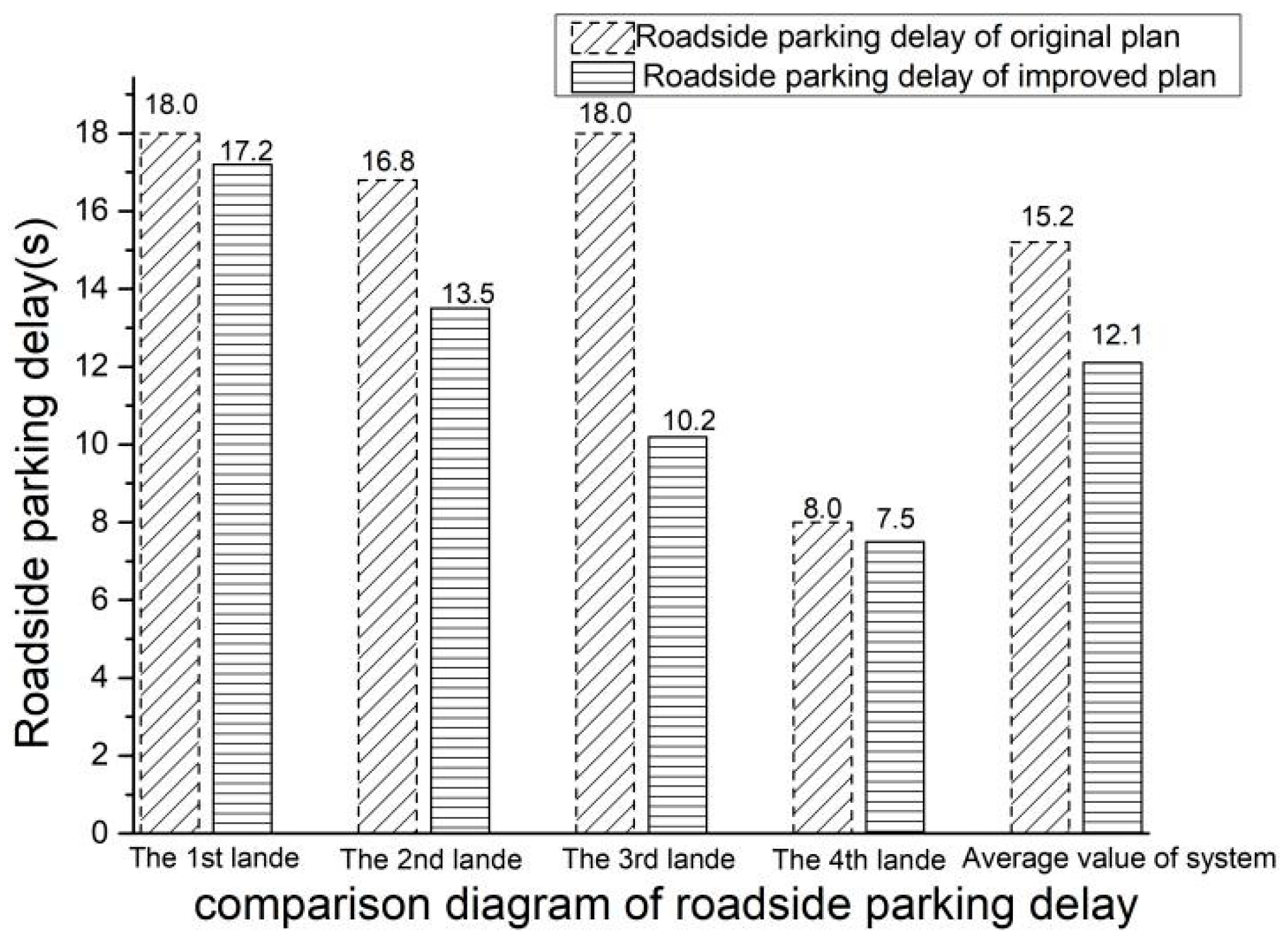
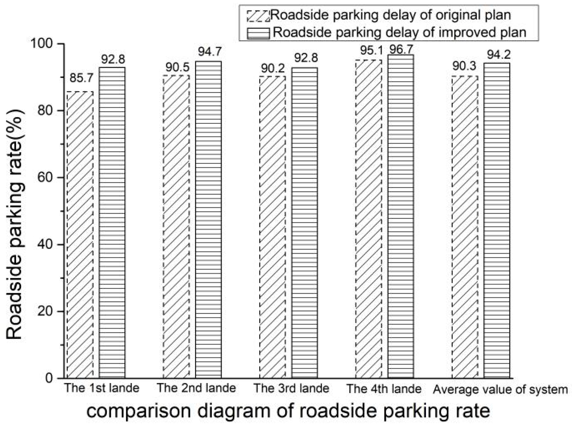
4.3. Simulation Evaluation of the Original Design Scheme of the Newly Built Rail-Integrated Transport Hub

The original plan comes from the planning of the rail-integrated transport hub of the Tangxi Station in Guangzhou, and the roadside parking system design plan is shown in Figure 8. The roadside parking system has nine lanes, with parking spaces in the inner lanes. Each lane set has 13 parking spaces (6 + 7), with a total of 65 parking spaces. One pedestrian crossing is set on the east, west, and middle.
The simulation model is run after building a microscopic traffic simulation model according to the design plan. A multi-agent simulation environment was constructed by designing the roadside parking vehicle as agents, and simulating the traffic scene in the design plan. Calibrating relevant simulation parameters according to Equations (6)–(8), and debugging and correcting the simulation model. Carrying out many times of simulation, take the average value, the roadside parking characteristic data are also collected, based on the simulation output results (Table 2).
Analysis results of Table 2 indicate that the North 1 lane occupies two adjacent lanes with 26 parking spaces, such that serious interference occurs between vehicles. Moreover, the utilization of inside parking spaces tends to be low because of the effect of pedestrian crossings, thereby resulting in low parking time utilization, with a parking rate of 85.7%. That rate is less than 91.2% of the limited stability status of the roadside system. Therefore, a queuing phenomenon occurs in the roadside parking system. Affected by the pedestrian crossings on the North 2 and North 3 lanes, the parking rates are 90.5% and 90.2%, respectively, and these values are less than 91.2% of the limited stability status of the roadside system. Thus, queuing occasionally occurs for vehicles on the roadside.
The overall parking rate of the roadside parking system is 90.3%, an outcome that means that the original design of the parking space is unreasonable. Furthermore, the parking space is insufficient, such that the vehicles start to queue outside the parking system and the system is unstable.

4.4. Simulation Evaluation of the Improved Scheme of the Newly Built Rail-Integrated Transport Hub

According to the simulation results of the original scheme, it is necessary to compare and select improvement schemes, reducing parking delays, and increasing the rate of roadside parking. The schemes simulation were carried out in the multi-agent simulation model of the roadside parking system. The simulation results show that the optimal scheme is when one parking space was added to each lane. The improvement scheme is as follows: five parking spaces are added, and 14 parking spaces (7 + 7) are added in each lane. A total of 70 parking spaces are set (Figure 9).
The simulation parameters according to the improved design plan are consistent with those of the original design plan. After debugging and correcting the simulation model, the simulation model was run, and the simulation results were shown in Table 3. Compared with the design plan, the improved design plan reduces roadside parking delay and increases the roadside parking rate. The comparison between the original and the improved plans is shown in Figure 10.
The analysis results of Figure 10 indicate that after the improvement, the parking rate of each lane becomes greater than 91% of the limited value of the roadside parking system. Therefore, roadside parking spaces are sufficient and no vehicle queue phenomenon occurs. In addition, the parking delays of all lanes are decreased, the overall parking rate is optimized and improved, the roadside parking system operates smoothly, the parking spaces are sufficient, and the roadside parking system is stable. Therefore, the improved plan is efficiently designed.
In summary, evaluating the roadside parking systems through indicators such as parking time utilization, parking rate, and delay is reasonable and can effectively guide the planning and design of roadside parking spaces in rail-integrated transport hubs.

5. Conclusions

In this paper, data in the roadside parking system model originated from the Guangzhou South Railway Station and Guangzhou East Railway Station, which the representative high-speed railway station and the railway station of China’s rail-integrated transport hubs, respectively. Through the study of the internal mechanism of the hubs, our research can provide auxiliary tools and scientific supports for the design and operation of the rail-integrated transport hubs.
We improved the algorithm of roadside parking time utilization by proposing two new concepts, such as static parking time and dynamic parking time. We analyzed the interaction mechanism inside the roadside parking system by using the traffic wave theory, and proposed the stability analysis strategy of roadside parking system by combining with the complex adaptive system theory. We found that when the parking time utilization rate and parking rate were 37.5% and 91.2%, respectively, the roadside parking system was in the ultimate stable state. We verified the correctness of the stability of the roadside parking system model by error analysis.
On the other hand, the theoretical model of roadside parking system has been verified by theory and simulation, and the model has universality and applicability, which will provide a theoretical foundation for the design and operation of other rail-integrated transport hubs. The operator of rail transit hubs should improve the design of a roadside parking system in the design stage to reduce traffic delays. In the later stage of operations, the operator can assist in terms of traffic organization and the division of traffic signs of the roadside parking system by setting up warning signs such as “Stop only for unloading passengers” and “Safe Parking”.
However, the stability of the roadside parking system is limited to the situation when the vehicle’s travel is affected by other factors (such as weather). Therefore, further research can focus on adjusting the model by taking other factors into consideration. In future, we will collect more internal mechanism data for different factors at different hubs to verify the effectiveness of the proposed model.

Author Contributions

Conceptualization, L.S.; Data curation, J.Y.; Funding acquisition, Q.L.; Investigation, L.S.; Methodology, J.Y., X.Z. and Q.L.; Software, L.S.; Supervision, X.Z.; Writing—original draft, J.Y.; Writing—review & editing, Q.L. All authors have read and agreed to the published version of the manuscript.

Funding

This research received no external funding.

Institutional Review Board Statement

Not applicable.

Informed Consent Statement

Not applicable.

Data Availability Statement

The data presented in this study are available on request from the corresponding author.

Acknowledgments

This work was supported by the National Key R&D Program of China (2019YFB1600602), Guangzhou University Research Project (YG2020004), Shanghai Committee of Science and Technology, China (18DZ1206300).

Conflicts of Interest

The authors declare no conflict of interest.

References

  1. Francesca, P.; Filomena, M. The Impact of High-Speed Rail on Tourism with Parametric and Non-Parametric Methods: The Case Study of China. Sustainability 2021, 13, 3416. [Google Scholar]
  2. Leclercq, L.; Sénécat, A.; Mariotte, G. Dynamic macroscopic simulation of on-street parking search: A trip-based approach. Transp. Res. Part B Methodol. 2017, 101, 268–282. [Google Scholar] [CrossRef] [Green Version]
  3. Arnott, R. On the optimal target curbside parking occupancy rate. Econ. Transp. 2014, 3, 133–144. [Google Scholar] [CrossRef] [Green Version]
  4. Cao, J.; Menendez, M. Quantification of potential cruising time savings through intelligent parking services. Transp. Res. Part A Policy Pract. 2018, 116, 151–165. [Google Scholar] [CrossRef]
  5. Geroliminis, N. Cruising-for-parking in congested cities with an MFD representation. Econ. Transp. 2015, 4, 156–165. [Google Scholar] [CrossRef]
  6. Zheng, N.; Geroliminis, N. Modeling and optimization of multimodal urban networks with limited parking and dynamic pricing. Transp. Res. Part B Methodol. 2016, 83, 36–58. [Google Scholar] [CrossRef] [Green Version]
  7. Du, Y.; Yu, S.; Meng, Q. Allocation of street parking facilities in a capacitated network with equilibrium constraints on drivers’ traveling and cruising for parking. Transp. Res. Part C Emerg. Technol. 2019, 101, 181–207. [Google Scholar] [CrossRef]
  8. Hunt, J.D. Parking location choice: Insights and representations based on observed behaviour and the hierarchical logit modelling formulation. In Proceedings of the Institute of Transportation Engineers (ITE), Annual Meeting, 58th, Vancouver, BC, Canada, 7–10 May 1988. [Google Scholar]
  9. Bradley, M.; Kroes, E.; Hinloopen, E. A joint model of mode/parking type choice with supply-constrained application. In Proceedings of the PTRC Summer Annual Meeting, 21st, University of Manchester, Manchester, UK, 13–17 September 1993. [Google Scholar]
  10. Kobus, M.B.W.; Gutierrez-I-Puigarnau, E.; Rietveld, P. The On-Street Parking Premium and Car Drivers’ Choice between Street and Garage Parking. Reg. Urban Econ. 2013, 43, 395–403. [Google Scholar] [CrossRef] [Green Version]
  11. Boyles, S.D.; Tang, S.P.; Unnikrishan, A. Parking Search Equilibrium on a Network. Transp. Res. Part B Methodol. 2015, 81, 390–409. [Google Scholar] [CrossRef] [Green Version]
  12. Millard-ball, A.; Weinberger, R.R.; Hampshire, R.C. Is the Curb 80% Full or 20% Empty? Assessing the Impacts of San Francisco’s Parking Pricing Experiment. Transp. Res. Part A Policy Pract. 2014, 63, 76–92. [Google Scholar] [CrossRef]
  13. Pei, Y.; Yang, Y. Block Delay Model Under the Influence of On-Street Parking in Two-Way Two-Lane Road. Urban Transp. China 2020, 18, 119–126. [Google Scholar]
  14. Zhao, C.; Zhu, Y. A Real-time Prediction Method of Curbside Parking Occupancy Incorporating Dynamic Management Policies. J. Transp. Syst. Eng. Inf. Technol. 2020, 20, 107–113. [Google Scholar]
  15. Zhang, Y.; Kong, D. Curb Parking Resource Allocation Method Based on Optimal Road Network Traffic Efficiency. Transp. Res. 2020, 6, 64–73. [Google Scholar] [CrossRef]
  16. Liu, X.; Wang, L. Cellular automaton traffic flow model considering on-street parking. J. Jilin Univ. (Eng. Technol. Ed.) 2012, 42, 327–333. [Google Scholar]
  17. Wei, L.; Liang, Y. On Delay Probability and Influence of Inside Road Parking Area Length on Traffic. J. Southwest China Norm. Univ. (Nat. Sci. Ed.) 2016, 5, 115–121. [Google Scholar]
  18. Yu, P. Design of Intelligent Parking Lots Management System Based on ARM; Guangxi Normal University: Guilin, China, 2015. [Google Scholar]
  19. Yin, H.; Shen, J.; Zheng, S. Research on Infuential Factors of Parking Demand in Central Business District with Logitsitc Model. J. Dalian Jiaotong Univ. 2017, 38, 25–30. [Google Scholar]
  20. Zhang, R.; Zhu, L.; Lin, J. Curb Parking Progressive Charging Pricing Model of City Center. J. Tongji Univ. (Nat. Sci.) 2015, 43, 90–95. [Google Scholar]
  21. Wang, Y.; Jia, S.; Li, J. A Model of Network Assignment for Multi-Mode Travel Considering Roadside Parking Charge Game. J. Transp. Inf. Saf. 2019, 37, 88–94+162. [Google Scholar]
  22. Li, L.; He, S.; Liang, X. A Method for Forecasting Parking Demand of Complex Under Consistent Feature. J. Tongji Univ. (Nat. Sci.) 2018, 46, 340–345. [Google Scholar]
  23. Cao, Y.; Yang, Z.; Zuo, Z. The Planning Method of Regional Parking Based on Railway Transit Park-and-ride. J. Transp. Syst. Eng. Inf. Technol. 2016, 16, 153–158. [Google Scholar]
  24. Holland, J.H. Complex adaptive systems. Daedalus 1992, 121, 17–30. [Google Scholar]
  25. Chen, X. Simulation Modelling and Its Application of pedestrian Mustering and Evacuation in Rail Transit Hubs; Beijing Jiaotong University: Beijing, China, 2018. [Google Scholar]
  26. Zhang, J.J. Analysis on the Influence Transmission of Expressway Traffic Accidents under the Environment of Road Network; Chang’an University: Xian, China, 2010. [Google Scholar]
  27. Cao, Z.Y.; Guo, Z.Y. Research on Time and Spatial Extent of Terrible Traffic Accident on Highway. Highw. Eng. 2011, 36, 56–58. [Google Scholar]
  28. Ye, X.; Chen, J.; Zhu, R. Modeling Optimal Distance Between Curb Parking Location and Exit of Signal Controlled Intersection. J. Highw. Transp. Res. Dev. 2012, 29, 110–117. [Google Scholar]
  29. Chen, J.; He, X. Road Traffic Delay Caused by Curb Parking Set in the Influence Area of Signalized Intersection. J. Harbin Inst. Technol. 2009, 41, 130–135. [Google Scholar]
  30. Poliak, M.; Poliaková, A.; Čulík, K. Impact of the Social Law on Truck Parking Sustainability in the EU. Sustainability 2020, 12, 9430. [Google Scholar] [CrossRef]
  31. Dong, G.; Zuo, Y. Study on Calculation Model of Number of Queuing Vehicles and Total Delay in Traffic Incidents. Comput. Technol. Autom. 2018, 37, 110–116. [Google Scholar]
  32. Reynolds, C.W. Open Steer: Steering Behaviors for Autonomous Characters; Miller Freeman Game Group: San Jose, CA, USA, 1999. [Google Scholar]
  33. Reynolds, C.W.; Flocks, H. And Schools: A Distributed Behavioral Model; ACM: New York, NY, USA, 1987. [Google Scholar]
  34. Zhang, J.; Cheng, Y. Improvement and lightweight implementation of a crowd evacuation model. Sci. Surv. Mapp. 2017, 42, 183–189. [Google Scholar] [CrossRef]
  35. Gonzalo, A. The Effect of Introducing Parking Policies on Managing Mobility to Beaches in Touristic Coastal Towns. Sustainability 2019, 11, 3528. [Google Scholar]
  36. Alessandro, C.; Tom, J.; Antonino, S. Designing a Web Spatial Decision Support System Based on Analytic Network Process to Locate a Freight Lorry Parking. Sustainability 2019, 11, 5629. [Google Scholar]
  37. Chen, B.; Cheng, H. A review of the applications of agent technology in traffic and transportation systems. IEEE Trans. Intell. Transp. Syst. 2010, 11, 485–497. [Google Scholar] [CrossRef]
  38. Béhé, S.; Gaud, N. An ontology-based metamodel for multiagent-based simulations. Simul. Model. Pract. Theory 2014, 40, 64–85. [Google Scholar] [CrossRef]
  39. Chen, X.; Wang, S. Robust Ship Tracking via Multi-view Learning and Sparse Representation. J. Navig. 2019, 72, 176–192. [Google Scholar] [CrossRef]
  40. Luo, Q.; Zang, X. Research of Vehicle Rear-End Collision Model considering Multiple Factors. Math. Probl. Eng. 2020, 1–11. [Google Scholar] [CrossRef] [Green Version]
  41. Luo, Q.; Chen, X.; Yuan, J. Study and Simulation Analysis of Vehicle Rear-End Collision Model considering Driver Types. J. Adv. Transp. 2020, 1–11. [Google Scholar] [CrossRef]
  42. Luo, Q.; Yuan, J.; Chen, X. Research on mixed user equilibrium model based on mobile internet traffic information service. IEEE Access 2019, 7, 164775–164790. [Google Scholar] [CrossRef]
  43. Chen, X.; Yang, Y.; Wang, S. Ship Type Recognition via a Coarse-to-Fine Cascaded Convolution Neural Network. J. Navig. 2020, 73, 813–832. [Google Scholar] [CrossRef]
  44. Chen, X. Augmented Ship Tracking Under Occlusion Conditions from Maritime Videos. IEEE Access 2020, 8, 42884–42897. [Google Scholar] [CrossRef]
  45. Javad, K. Spatial Analysis of Curb-Park Violations and Their Relationship with Points of Interest: A Case Study of Tehran, Iran. Sustainability 2019, 11, 6336. [Google Scholar]
  46. Majda, I. Decision Support to Sustainable Parking Management—Investment Planning through Parking Fines to Improve Pedestrian Flows. Sustainability 2020, 12, 9485. [Google Scholar]
  47. Luo, Q.; Yuan, J. Analyzing start-up time headway distribution characteristics at signalized intersections at signalized intersections. Phys. A Stat. Mech. Its Appl. 2019, 535, 1–10. [Google Scholar]
Figure 1. The development of curb parking system.
Sustainability 13 04855 g001
Figure 2. Multi-agent simulation model of the curb parking system.
Sustainability 13 04855 g002
Figure 3. The fitting curve of time utilization rate-delay fitting curve.
Sustainability 13 04855 g003
Figure 4. The fitting curve of parking time utilization rate-roadside parking rate.
Sustainability 13 04855 g004
Figure 5. Roadside parking model.
Sustainability 13 04855 g005
Figure 6. 3d model of Multi-agent simulation.
Sustainability 13 04855 g006
Figure 7. The fitting curve of parking time utilization rate-roadside parking delay.
Sustainability 13 04855 g007
Figure 8. The original design plan drawing.
Sustainability 13 04855 g008
Figure 9. The improved design plan drawing.
Sustainability 13 04855 g009
Figure 10. Comparison diagram of simulation evaluation result of the improved plan drawing.
Sustainability 13 04855 g010aSustainability 13 04855 g010b
Table 1. The sample size of roadside parking characteristics was determined.
Sample   Estimated   Standard   Deviation   ( S ) Confidence   Level   ( t α / 2 ) Allowable   Error   ( E ) Minimum Sample Size ( n ) Actual Survey Sample Size
Traffic   volume   ( pcu min 1 ) 100.001.643.00674213,580
Roadside parking duration(s)30.001.642.002693795
Roadside parking delay(s)0.451.640.05218576
Table 2. The simulation evaluation result of the original plan drawing.
Roadside Parking Delay(s)Roadside Parking Rate (%)
The 1st lane (north)18.085.7
The 2nd lane (north)16.890.5
The 3rd lane (north)18.090.2
The 4th lane (north)8.095.1
The average value of roadside parking system15.290.3
Table 3. The simulation evaluation result of the original improved drawing.
Roadside Parking Delay(s)Roadside Parking Rate (%)
The 1st lane (north)17.292.8
The 2nd lane (north)13.594.7
The 3rd lane (north)10.292.8
The 4th lane (north)7.596.7
The average value of roadside parking system12.194.2
Publisher’s Note: MDPI stays neutral with regard to jurisdictional claims in published maps and institutional affiliations.

