
Long-Term Urbanization Dynamics and the Evolution of Green/Blue Areas in Eastern Europe: Insights from Romania


Abstract
:1. Introduction
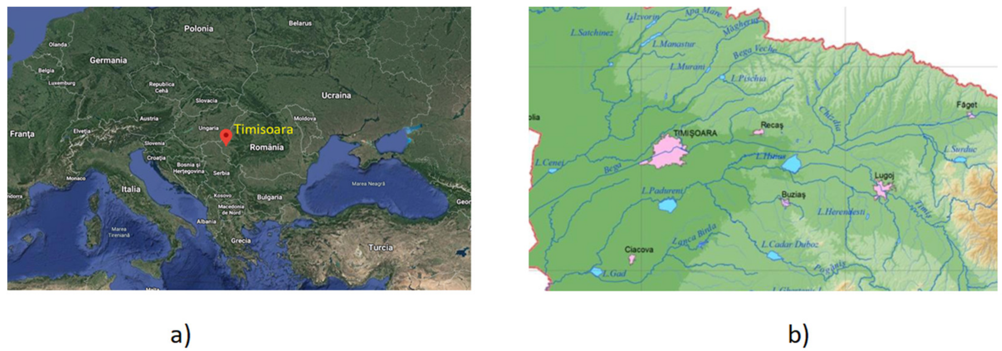
2. Study Area
2.1. Climate
2.2. Hydrography
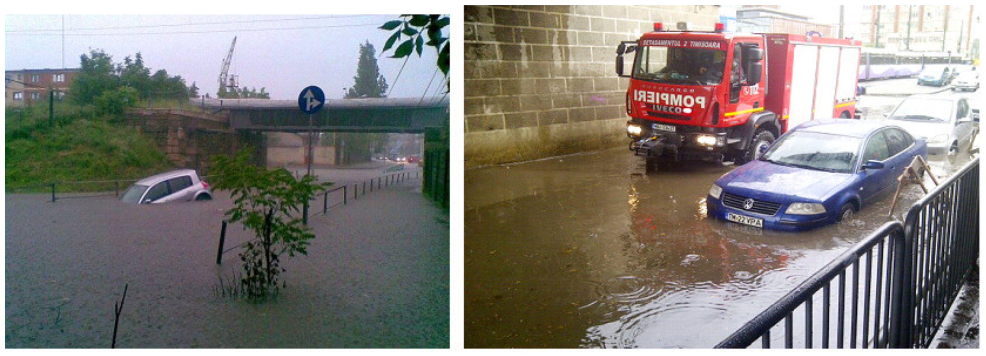
3. Long-Term Urbanization Dynamics, Flooding and Evolution of Grey Areas in Western Romania
4. Methodology
5. A Historical Profile of Long-Term Green/Blue Areas Dynamics
- -
- A “nature as usual” period, which overlaps, from the historical point of view, with ancient and medieval times;
- -
- Urban consolidation overlapping with the modern period (1716–1918);
- -
- An “aesthetical” stage corresponding to the interwar period (1918–1940);
- -
- Intense urbanization corresponding with the second half of the 20th century;
- -
- Planned development starting at the beginning of the 21st century.
5.1. “Nature as Usual” Time
5.2. The Modern Period (1716–1918)
5.3. The “Aesthetic” Stage (1716–1918)
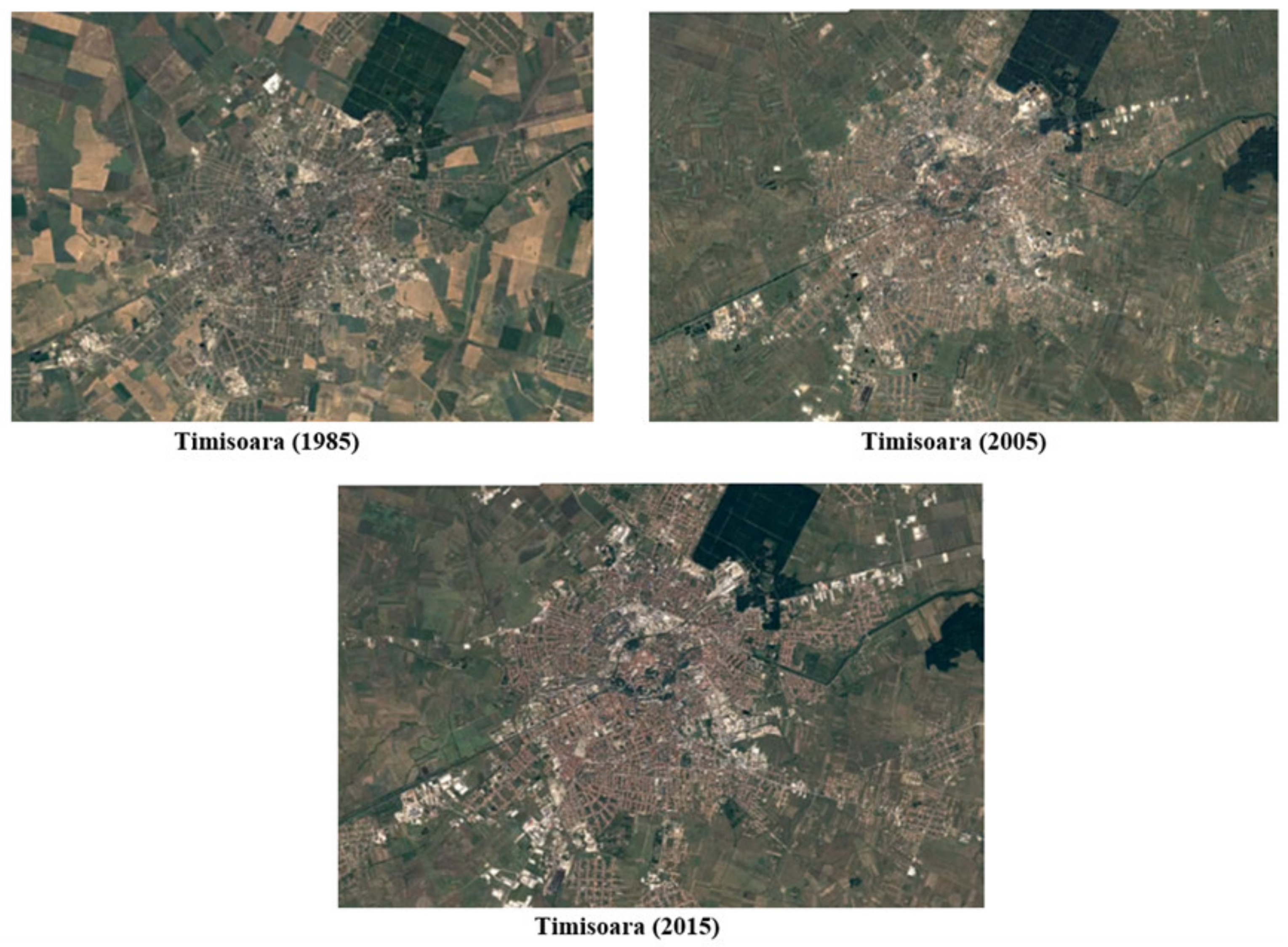
5.4. The Urbanization Stage (Second Half of the XX Century)
5.5. Planned Urban Development (the 21th Century)
6. Factors Affecting Green/Blue Areas Dynamics
- -
- the existing hygienic–sanitary conditions;
- -
- climate hazards;
- -
- military conditions;
- -
- political conditions;
- -
- rural–urban and urban–rural migration;
- -
- real estate speculation;
- -
- socioeconomic development;
- -
- aesthetic interests.
6.1. The Existing Hygienic–Sanitary Conditions
6.2. Climate Hazards
6.3. Military Conditions
6.4. Political Context
6.5. Rural–Urban and Urban–Rural Migration
6.6. Real Estate Speculation
6.7. Socioeconomic Development
6.8. Aesthetic Interests
7. Concluding Remarks
Author Contributions
Funding
Institutional Review Board Statement
Informed Consent Statement
Conflicts of Interest
References
- Bai, X.; Shi, P.; Liu, Y. Society: Realizing China’s urban dream. Nature 2014, 509, 158–160. [Google Scholar] [CrossRef] [Green Version]
- Grimm, N.B.; Faeth, S.H.; Golubiewski, N.E.; Redman, C.L.; Wu, J.; Bai, X.; Briggs, J.M. Global change and the ecology of cities. Science 2008, 319, 756–760. [Google Scholar] [CrossRef] [Green Version]
- McPhearson, T.; Pickett, S.T.A.; Grimm, N.B.; Niemela, J.; Alberti, M.; Elmqvist, T.; Weber, C.; Haase, D.; Breuste, J.; Qureshi, S. Advancing urban ecology toward a science of cities. BioScience 2016, 66, 198–212. [Google Scholar] [CrossRef] [Green Version]
- Säynäjoki, E.S.; Heinonen, J.; Junnila, S. The Power of Urban Planning on Environmental Sustainability: A Focus Group Study in Finland. Sustainability 2014, 6, 6622–6643. [Google Scholar] [CrossRef] [Green Version]
- Salvati, L.; Serra, P. Estimating rapidity of change in complex urban systems: A multidimensional, local-scale approach. Geogr. Anal. 2016, 48, 132–156. [Google Scholar] [CrossRef]
- Niemela, J. Ecology and urban planning. Biodivers. Conserv. 1999, 8, 119–131. [Google Scholar] [CrossRef]
- Goudie, A.S. The Human Impact on the Natural Environment: Past, Present, and Future; Wiley: New York, NY, USA, 2013. [Google Scholar]
- Soga, M.; Yamaura, Y.; Koike, S.; Gaston, K.J. Land sharing vs. land sparing: Does the compact city reconcile urban development and biodiversity conservation? J. Appl. Ecol. 2014, 51, 1378–1386. [Google Scholar] [CrossRef]
- Panagopoulos, T.; González Duque, J.A.; Bostenaru, D.M. Urban planning with respect to environmental quality and human wellbeing. Environ. Pollut. 2016, 208, 137–144. [Google Scholar] [CrossRef] [Green Version]
- Mersal, A. Sustainable urban futures: Environmental planning for sustainable urban development. Procedia Environ. Sci. 2016, 34, 49–61. [Google Scholar] [CrossRef] [Green Version]
- Pili, S.; Grigoriadis, E.; Carlucci, M.; Clemente, M.; Salvati, L. Towards sustainable growth? A multi-criteria assessment of (changing) urban forms. Ecol. Indic. 2017, 76, 71–80. [Google Scholar] [CrossRef]
- Samuelsson, K.; Giusti, M.; Peterson, G.D.; Legeby, A.; Anders Brandt, S.; Barthel, S. Impact of environment on people’s everyday experiences in Stockholm. Landsc. Urban Plan. 2018, 171, 7–17. [Google Scholar] [CrossRef]
- Duvernoy, I.; Zambon, I.; Sateriano, A.; Salvati, L. Pictures from the other side of the fringe: Urban growth and peri-urban agriculture in a post-industrial city (Toulouse, France). J. Rural. Stud. 2018, 57, 25–35. [Google Scholar] [CrossRef]
- Leitão, I.A.; Ferreira, C.S.S.; Ferreira, A.J.D. Assessing long-term changes in potential ecosystem services of a peri-urbanizing Mediterranean catchment. Sci. Total Environ. 2019, 660, 993–1003. [Google Scholar] [CrossRef]
- Morelli, V.G.; Rontos, K.; Salvati, L. Between suburbanisation and re-urbanisation: Revisiting the urban life cycle in a Mediterranean compact city. Urban Res. Pract. 2014, 7, 74–88. [Google Scholar] [CrossRef]
- Colantoni, A.; Mavrakis, A.; Sorgi, T.; Salvati, L. Towards a ‘polycentric’ landscape? Reconnecting fragments into an integrated network of coastal forests in Rome. Rend. Lincei 2015, 26, 615–624. [Google Scholar] [CrossRef]
- Cuadrado-Ciuraneta, S.; Durà-Guimerà, A.; Salvati, L. Not only tourism: Unravelling suburbanization, second-home expansion and “rural” sprawl in Catalonia, Spain. Urban Geogr. 2017, 38, 66–89. [Google Scholar] [CrossRef]
- Taubenbock, H.; Gerten, C.; Rusche, K.; Siedentop, S.; Wurm, M. Patterns of Eastern Europe urbanization in the mirror of Western trends—Convergent, unique or hybrid? Urban Anal. City Sci. 2019, 46, 1206–1225. [Google Scholar]
- Zambon, I.; Serra, P.; Sauri, D.; Carlucci, M.; Salvati, L. Beyond the ‘Mediterranean city’: Socioeconomic disparities and urban sprawl in three Southern European cities. Geogr. Ann. Ser. B Hum. Geogr. 2017, 99, 319–337. [Google Scholar] [CrossRef]
- Zambon, I.; Benedetti, A.; Ferrara, C.; Salvati, L. Soil matters? A multivariate analysis of socioeconomic constraints to urban expansion in Mediterranean Europe. Ecol. Econ. 2018, 146, 173–183. [Google Scholar] [CrossRef]
- Salvati, L.; Carlucci, M. Land-use structure, urban growth, and periurban landscape: A multivariate classification of the European cities. Environ. Plan. B Plan. Des. 2015, 42, 801–829. [Google Scholar] [CrossRef]
- Pezzagno, M.; Frigione, B.M.; Ferreira, C.S.S. Reading Urban Green Morphology to Enhance Urban Resilience: A Case Study of Six Southern European Cities. Sustainability 2021, 13, 9163. [Google Scholar] [CrossRef]
- Sýkora, L.; Stanilov, K. The challenge of postsocialist suburbanization. In Confronting Suburbanization: Urban Decentralization in Postsocialist Central and Eastern Europe; Stanilov, K., Sýkora, L., Eds.; Wiley Blackwell: Chichester, UK, 2014; pp. 1–32. [Google Scholar]
- Schmidt, S.; Siedentop, S.; Fina, S. Post-socialist sprawl: A cross-country comparison. Eur. Plan. Stud. 2015, 23, 1357–1380. [Google Scholar] [CrossRef]
- Ianos, I.; Sîrodoev, I.; Pascariu, G.; Henebry, G. Divergent patterns of built-up urban space growth following post-socialist changes. Urban Stud. 2016, 53, 3172–3188. [Google Scholar] [CrossRef]
- Mitrica, B.; Grigorescu, I.; Urucu, V. Urban development and metropolitan areas. In Sustainable Development and Metropolitan Areas; Balteanu, D., Dumitrascu, M., Geacu, S., Mitrica, B., Sima, M., Eds.; Romanian Academy Publishing House: Bucharest, Romania, 2016. (In Romanian) [Google Scholar]
- Romanian Government; Ministry of Waters, Forests and Environmental Protection of Romania. Environment Protect Strategy; Romanian Government; Ministry of Waters, Forests and Environmental Protection of Romania: Bucharest, Romania, 2003; 178p.
- Cecchini, M.; Zambon, I.; Pontrandolfi, A.; Turco, R.; Colantoni, A.; Mavrakis, A.; Salvati, L. Urban sprawl and the ‘olive’ landscape: Sustainable land management for ‘crisis’ cities. GeoJournal 2019, 84, 237–255. [Google Scholar] [CrossRef]
- Barbati, A.; Corona, P.; Salvati, L.; Gasparella, L. Natural forest expansion into suburban countryside: Gained ground for a green infrastructure? Urban For. Urban Green. 2013, 12, 36–43. [Google Scholar] [CrossRef] [Green Version]
- Gavalas, V.S.; Rontos, K.; Salvati, L. Who becomes an unwed mother in Greece? Sociodemographic and geographical aspects of an emerging phenomenon. Popul. Space Place 2014, 20, 250–263. [Google Scholar] [CrossRef]
- Rontos, K.; Grigoriadis, E.; Sateriano, A.; Syrmali, M.; Vavouras, I.; Salvati, L. Lost in protest, found in segregation: Divided cities in the light of the 2015 “Oχι” referendum in Greece. City Cult. Soc. 2016, 7, 139–148. [Google Scholar] [CrossRef]
- Di Feliciantonio, C.; Salvati, L.; Sarantakou, E.; Rontos, K. Class diversification, economic growth and urban sprawl: Evidences from a pre-crisis European city. Qual. Quant. 2018, 52, 1501–1522. [Google Scholar] [CrossRef]
- Ferreira, C.S.S.; Walsh, R.P.D.; Nunes, J.P.C.; Steenhuis, T.S.; Nunes, M.; de Lima, J.L.M.P.; Coelho, C.O.A.; Ferreira, A.J.D. Impact of urban development on streamflow regime of a Portuguese peri-urban Mediterranean catchment. J. Soils Sediments 2016, 16, 2580–2593. [Google Scholar] [CrossRef]
- Kalantari, Z.; Ferreira, C.S.S.; Walsh, R.P.D.; Ferreira, A.J.D.; Destouni, G. Urbanization development under climate change: Hydrological responses in a peri-urban Mediterranean catchment. Land Degrad. Dev. 2017, 28, 2207–2221. [Google Scholar] [CrossRef] [Green Version]
- Ferreira, C.S.S.; Walsh, R.P.D.; Steenhuis, T.S.; Ferreira, A.J.D. Effect of Peri-urban Development and Lithology on Streamflow in a Mediterranean Catchment. Land Degrad. Dev. 2018, 29, 1141–1153. [Google Scholar] [CrossRef]
- Pinto, L.V.; Ferreira, C.S.S.; Ferreira, A.; Kalantari, Z.; Pereira, P. Green and Blue Infrastructure (GBI) in Urban Areas. In The Palgrave Encyclopedia of Urban and Regional Futures; Brears, R., Ed.; Springer: Berlin/Heidelberg, Germany, 2021. [Google Scholar] [CrossRef]
- Ferreira, C.S.S.; Mourato, S.; Ksanin-Grubin, M.; Ferreira, A.J.D.; Destouni, G.; Kalantari, Z. Effectiveness of Nature-Based Solutions in Mitigating Flood Hazard in a Mediterranean Peri-Urban Catchment. Water 2020, 12, 2893. [Google Scholar] [CrossRef]
- Kalantari, Z.; Ferreira, C.S.S.; Page, J.; Goldenberg, R.; Olsson, J.; Destouni, G. Meeting Sustainable Development Challenges in Growing Cities: Coupled Social Ecological Systems Modeling of Land Use and Water Changes. J. Environ. Manag. 2019, 249, 471–480. [Google Scholar] [CrossRef] [PubMed]
- Pinto, L.; Ferreira, C.S.S.; Pereira, P. Environmental and socioeconomic factors influencing the use of urban green spaces in Coimbra (Portugal). Sci. Total Environ. 2021, 792, 148293. [Google Scholar] [CrossRef]
- Biasi, R.; Colantoni, A.; Ferrara, C.; Ranalli, F.; Salvati, L. In-between sprawl and fires: Long-term forest expansion and settlement dynamics at the wildland–urban interface in Rome, Italy. Int. J. Sustain. Dev. World Ecol. 2015, 22, 467–475. [Google Scholar] [CrossRef]
- United Nations. New Urban Agenda. 2017. Available online: https://habitat3.org/the-new-urban-agenda/ (accessed on 31 March 2021).
- European Commission. EU Biodiversity Strategy for 2030—Bringing Nature Back into Our Lives; European Commission: Brussels, Belgium, 2020. [Google Scholar]
- Barbu, S.; Mircov, V. From the weather to climate in the western plain. Res. J. Agric. Sci. 2013, 45, 209–222. [Google Scholar]
- Irimia, L.M.; Patriche, C.V.; Rosca, B.; Cotea, V.V. Modifications in Climate Suitability for Wine Production of Romanian wine Regions as a Result of Climate Change. In Proceedings of the 40th World Congress of Vine and Wine, BIO Web of Conferences, Sofia, Bulgaria, 29 May–2 June 2017; Volume 9, p. 01026. [Google Scholar] [CrossRef] [Green Version]
- Dunca, A.M. Monitoring long-term air temperature regime in Banat (Romania). Annals of Valahia University of Targoviste. Geogr. Ser. 2018, 18, 74–83. [Google Scholar] [CrossRef] [Green Version]
- Rowell, D.P. A scenario of European Climate Change for the late twenty-first century: Seasonal means and interannual variability. Clim. Dyn. 2005, 25, 837–849. [Google Scholar] [CrossRef]
- Christensen, J.H.; Hewitson, B.; Busuioc, A.; Chen, A.; Gao, X.; Held, I.; Jones, R.; Kolli, R.K.; Kwon, W.T.; Laprise, R.; et al. Regional climate projections. In The Physical Science Basis. Contribution of Working Group I to the Fourth Assessment Report of the Intergovernmental Panel on Climate Change; Solomon, S., Qin, D., Manning, M., Chen, Z., Marquis, M., Averyt, K.B., Tignor, M., Miller, H.L., Eds.; Cambridge University Press: Cambridge, UK; New York, NY, USA, 2007; pp. 847–940. [Google Scholar]
- Kjellstrom, E.; Barring, L.; Jacob, D.; Jones, R.; Lenderink, G.; Schar, C. Modelling daily temperature extremes: Recent climate and future changes over Europe. Clim. Chang. 2007, 81, 249–265. [Google Scholar] [CrossRef]
- Solomon, S.; Qin, D.; Manning, M.; Chen, Z.; Marquis, M.; Averyt, K.B.; Tignor, M.; Miller, H.L. (Eds.) Climate Change. The Physical Science Basis. Contribution of Working Group I to the Fourth Assessment Report of the Intergovernmental Panel on Climate Change; Cambridge University Press: Cambridge, UK; New York, NY, USA, 2007; pp. 847–940. [Google Scholar]
- Anders, I.; Stagl, J.; Auer, I.; Pavlik, D. Climate Change in Central and Eastern Europe. In Managing Protected Areas in Central and Eastern Europe under Climate Change; Rannow, S., Neubert, M., Eds.; Springer Science and Business Media: Dordrecht, The Netherlands, 2014; pp. 17–30. [Google Scholar] [CrossRef]
- Nicoara, T. Climatic variations and collective mentalities in the 18th and early 19th centuries (1700–1830). Stud. Commun. 1987, XI–XII, 264–274. (In Romanian) [Google Scholar]
- Balan, E. Brief History of Floods in the Romanian Space in the XIII-XXI Centuries. Available online: https://www.academia.edu/ (accessed on 4 April 2021).
- Vlaicu, I.; Hategan, I. Water Supply of Timisoara: History, Present and Perspectives; Brumar Publishing House: Timisoara, Romania, 2012. (In Romanian) [Google Scholar]
- Negrescu, M.; Pura, D. Navigation on the Bega River—Historical Sequences; Timis County Council, Center for Culture and Art of Timis County, Timis County Directorate of National Archives, Timişoara, Brumar Publishing House: Timișoara, Romania, 2006. (In Romanian) [Google Scholar]
- Pisota, I.; Moisiu, C. Observations on Some Hydrological Phenomena Produced in the Flood Zone of the Lower Mures. In Bulletin of the Romanian Geographical Sciences Society; Editions de l’Academie Republique Populaire: Bucharest, Romania, 1973; Volume 3, p. 70. [Google Scholar]
- Turnock, D. Water Resource Management Problems in Romania. GeoJournal 1979, 3, 609–622. [Google Scholar] [CrossRef]
- Botzan, M. The Beginning of Hydrotechnics of Romania’s Territory; Technical Publishing House: Bucharest, Romania, 1994. (In Romanian) [Google Scholar]
- Cazacu, E.; Dobre, V.; Mihnea, I.; Pricop, G.; Rosca, M.; Sarbu, E.; Stanciu, I.; Wehry, A. Surface Drainage; Ceres Publishing House: Bucharest, Romania, 1985. (In Romanian) [Google Scholar]
- Giurescu, C.C. The History of Romanian Forests from the Earliest Times to Today; Ceres Publishing House: Bucharest, Romania, 1976. [Google Scholar]
- Kakucs, L. From the Pacha’s Fountain near the Dervishes‘Monastery to the Park of Roses. Contributions to the History of the Parks in Timişoara, Annals of Banatului, S.N. Archeology—History. 2015, Volume XXIII. Available online: https://muzeulbanatului.ro/mbt/istorie/publicatii/ab.htm (accessed on 9 April 2021).
- Kaut, H. Vienna Gardens. In Four Centuries of Garden Art; Bergland Verl Publishing House: Wien, Austria, 1964. (In German) [Google Scholar]
- Vartaciu, R. Timisoara in Prints: 16th–18th Centuries; Banatului Museum: Timisoara, Romania, 1993. (In Romanian) [Google Scholar]
- Karácson, I. The Trips to Hungary of the Turks Evlyia Celebi 1660–1664; Magyar Tudomanyos Akademia: Budapest, Hungary, 1904. (In Hungarian) [Google Scholar]
- Fenesan, C. The Otoman Culture of Timisoara Villayet; West Publishing House: Timisoara, Romania, 2006. (In Romanian) [Google Scholar]
- Munteanu, I.; Munteanu, R. Timis. Monography; Marineasa Publishing House: Timisoara, Romania, 1998. (In Romanian) [Google Scholar]
- Munteanu, I.; Munteanu, R. Timisoara. Monography; Mirton Publishing House: Timisoara, Romania, 2002. (In Romanian) [Google Scholar]
- Dudas, V.; Hategan, I.; Berghian, S.; Gombos, C.C.; Cernicova, M. From the chronology of Timis County; Marineasa Publishing House: Timisoara, Romania, 2004. (In Romanian) [Google Scholar]
- Szentkláray, J. Mercy’s Government in the Tennessee Banat. Further Details Southern Hungary XVIII. Century History; Hungarian Academy of Sciene Publishins House: Budapest, Hungary, 1909. (In Hungarian) [Google Scholar]
- Jesner, S. The World of Work in the Habsburg Banat (1716–51/53): Early Concepts of State-Based Social and Healthcare Schemes for Imperial Staff and Relatives. Austrian Hist. Yearb. 2019, 50, 58–77. [Google Scholar] [CrossRef]
- Berkeszi, I. István Bogma’s Diary Notes on the Siege of Timisoara in 1849. J. South. Hung. Hist. Archaeol. Soc. 1904, 20, 67–86. (In Hungarian) [Google Scholar]
- Glăvan, C. Defortification of the Timisoara fortress. AnB SN Arheol. Istor. 2013, XXI, 421–430. [Google Scholar]
- Hategan, I.; Petroman, C. Timisoara History, 2nd ed.; Banatului Publishing House: Timisoara, Romania, 2008. [Google Scholar]
- Ilieșiu, N. Timișoara: Historic Monography, 2nd ed.; Planetarium Publishing House: Timișoara, Romania, 2003; pp. 319–320. (In Romanian) [Google Scholar]
- Geml, I. Old Temesvar in the Last Half Century 1870–1920; Helicon Publishing House: Timișoara, Romania, 1927. (In German) [Google Scholar]
- Ciupa, V.; Nica, D.M.; Burtic, D.E.; Arsenie, O.E.; Banda, S.; Ciaca, F.V.; Craciun, C.; Danet, C. Natural and Landscape Framework of Timisoara Municiplaity; Timisoara Municipality: Timisoara, Romania, 2010. [Google Scholar]
- Popescu, L. Aspects of the interwar Timisoara administration. Patrim. Banat. 2006, 5, 99–109. [Google Scholar]
- Ciupa, V.; Radoslav, R.; Oarcea, C.; Oarcea, Z. Timişoara Verde—The Green Space System of Timişoara; Marineasa Publishing House: Timişoara, Romania, 2005. [Google Scholar]
- Ciupa, V.; Borza, D.; Burtic, D. The Strategy of Green Spaces in the New Landscape Conception; Artpress Publishing House: Timişoara, Romania, 2003. [Google Scholar]
- Mazurski, K.R. Communism and the environment. Forum Appl. Res. Public Policy 1991, 5, 39–44. [Google Scholar]
- Timisoara Municipality. Timisoara Municipality Green Spaces Development Strategy 2010–2020; Timisoara Municipality: Timişoara, Romania, 2010. [Google Scholar]
- European Commission EC. Green Paper on the Urban Environment; European Commission EC: Brussels, Belgium, 1990. [Google Scholar]
- Romanian Government. Law No. 24/2007 on the Regulation and Administration of Green Spaces in Urban Areas. Official Gazette no. 36, 18 January 2007.
- INSSE. Statistical Data Regarding the Population of Dumbravita Locality; National Institute of Statistics Publishing House: Timis County, Romania, 2020.
- ESPON. Territorial Dynamics in Europe. Evidence for a European Urban Agenda; Territorial Observation No. 13; ESPON: Luxembourg, 2014. [Google Scholar]


| Period | Covered Interval | Information Sources |
|---|---|---|
| Nature as usual | Up to 1716 | Historical sources, documents of historical character (e.g., censuses), national and international literature |
| Urban consolidation | 1716–1918 | Historical sources, administrative and military maps, documents of historical character (e.g., censuses), national and international literature |
| Aesthetical age | 1918–1940 | Historical sources, statistical documents, national and international literature |
| Intense urbanization | 1940–2000 | Statistical documents, local, regional and national administration documents, national and international literature, local and national policies |
| Planned development | Since 2000 | Statistical documents, local, regional and national administration documents, national and international literature, local, regional, national and European policies |
| Period | Covered Interval | Motivation for Selecting the Age Interval |
|---|---|---|
| Nature as usual | Up to 1716 | The period corresponds to ancient and medieval times poor in sources of information. Throughout the period, the city has known various occupants, so that there is no uniformity in the urban development from the point of view of the urbanism–environment relationship. |
| Urban consolidation | 1716–1918 | These two centuries are characterized by the development of the city within the Habsburg monarchy and later the Austro-Hungarian monarchy. It is generally urban development driven by a Western European model that takes into account both socio-economic needs and aesthetic and environmental aspects. From this period, Timisoara became known as Little Vienna. |
| Aesthetical age | 1918–1940 | The city becomes part of today’s Romania, under Romanian administration. However, the large number of inhabitants of German origin contributes to the preservation of aesthetic sense and as a consequence to the preservation of green areas. |
| Intense urbanization | 1940–2000 | The installation of the communist regime (1945) leads to the imposition of an intensive urbanization system. The period 1990–2000 is known in Romania as a period in which the setbacks and subsequent economic stagnation, and the lack of a clear and efficient post-communist legislation, did not allow significant steps regarding urban development and/or harmonization of the urbanism–environment relationship. Thus, we can say that the first 10 years of post-communism in Romania were not delimited by the communist period in terms of a positive dynamics of green urban areas—on the contrary, a downward trend was maintained in these areas. |
| Planned development | Since 2000 | Starting with the year 2000, Romania entered a period of economic growth and stability, with access to the European structures that allowed the adoption of an urban planning system in accordance with European standards. |
| Factor | →1716 | 1716–1918 | 1918–1940 | 1940–2000 | 2000→ |
|---|---|---|---|---|---|
| Hygienic–sanitary conditions | Positive | Positive | Neutral | Neutral | Positive |
| Climate hazards (including flood evolution) | Neutral | Positive | Neutral | Neutral | Positive |
| Military conditions | Negative | Negative | Positive | Neutral | Neutral |
| Political conditions | Positive | Negative | Positive | Neutral | Positive |
| Rural–urban migration | Neutral | Neutral | Neutral | Negative | Negative |
| Real estate speculation | Neutral | Neutral | Negative | Negative | Negative |
| Socioeconomic development | Neutral | Positive | Positive | Negative | Negative |
| Aesthetic interests | Positive | Positive | Positive | Neutral | Positive |
Publisher’s Note: MDPI stays neutral with regard to jurisdictional claims in published maps and institutional affiliations. |
© 2021 by the authors. Licensee MDPI, Basel, Switzerland. This article is an open access article distributed under the terms and conditions of the Creative Commons Attribution (CC BY) license (https://creativecommons.org/licenses/by/4.0/).
Share and Cite
Halbac-Cotoara-Zamfir, R.; Ferreira, C.S.S.; Salvati, L. Long-Term Urbanization Dynamics and the Evolution of Green/Blue Areas in Eastern Europe: Insights from Romania. Sustainability 2021, 13, 14068. https://doi.org/10.3390/su132414068
Halbac-Cotoara-Zamfir R, Ferreira CSS, Salvati L. Long-Term Urbanization Dynamics and the Evolution of Green/Blue Areas in Eastern Europe: Insights from Romania. Sustainability. 2021; 13(24):14068. https://doi.org/10.3390/su132414068
Chicago/Turabian StyleHalbac-Cotoara-Zamfir, Rares, Carla Sofia Santos Ferreira, and Luca Salvati. 2021. "Long-Term Urbanization Dynamics and the Evolution of Green/Blue Areas in Eastern Europe: Insights from Romania" Sustainability 13, no. 24: 14068. https://doi.org/10.3390/su132414068