Review

A Review on Sustainability of Watershed Management in Indonesia

1
Forest Research and Development Center, The Ministry of Environment and Forestry, Jl. Gunung Batu No. 5, Bogor 16118, West Java, Indonesia
2
Watershed Management Technology Center, Jl. Jend. A. Yani, Surakarta 57169, Central Java, Indonesia
3
Non-Timber Forest Products Technology Research and Development Institute, Jl. Dharma Bakti No. 7, Mataram 83371, West Nusa Tenggara, Indonesia
4
Environment and Forestry Research and Development Institute of Palembang, Jl. Kol. H. Burlian, km 6.5, Palembang 30154, South Sumatra, Indonesia
5
Center for Research and Development of Social, Economy, Policy and Climate Change, Jl. Gunung Batu No. 5, Bogor 16118, West Java, Indonesia
6
Environment and Forestry Research and Development Institute of Banjarbaru, Jl. Ahmad Yani, km 28.7, Banjarbaru 70721, South Kalimantan, Indonesia
*
Author to whom correspondence should be addressed.
Sustainability 2021, 13(19), 11125; https://doi.org/10.3390/su131911125
Submission received: 18 August 2021 / Revised: 30 September 2021 / Accepted: 30 September 2021 / Published: 8 October 2021
(This article belongs to the Special Issue Environmental Management Optimization)

Abstract

:
This paper provides an overview of the implementation and obstacles of watershed management, and the alternative solutions based on a synoptic review of related studies and experiences across Indonesia. The review found that problems in the institutional aspect were hierarchical confusion, discrepancy, and asynchrony among regulations, and weak (participation, synchronization, and coordination) among watershed management stakeholders. The weaknesses in the planning stage are integration among sectors, a lack of community participation, and limited readiness to integrate watershed planning into regional planning. Stakeholders’ involvement is also a critical factor in successful implementation of degraded watershed rehabilitation, including in peatland and mangrove areas. Failure should be minimized by providing adequate information on degraded watershed characteristics, appropriate species choices, and effective mechanical construction for soil and water conservation. Community participation as the main factor in driving watershed management should be achieved by strengthening public awareness of the importance of a sustainable watershed and providing access for the community to be involved in each stage of watershed management. Another problem is data gaps which are essential to address from the planning to evaluation stages. The gaps can be bridged by using remotely sensed data and by applying hydrological-based simulation models. Simplified criteria for watershed assessment may also be required, depending on site-specific issues and the watershed scale.

1. Introduction

Indonesia is committed to its Sustainable Development Goals (SDGs) as a global action plan for the next 15 years. To achieve the SDGs, the government must ensure that environmental conditions are within tolerance limits for human welfare and resources are in a safe quantity and quality range to support life and the national economy. This condition will be achieved, among other ways, through sustainable watershed management, which ensures the provision of clean water, sustainable use of terrestrial and aquatic ecosystems, prevention of continued land degradation, and rehabilitation of degraded forests and land resources [1].
A watershed can be defined as a topographically delineated area drained through a stream system to a point in a stream known as an outlet [2]. A more detailed definition is provided in Government Regulation No.37/2012 as a reference in watershed management in Indonesia [3]. A watershed is not only a topographical boundary of a hydrological unit; it can also be used as a socioeconomic and political unit to manage available natural resources [2,4]. Using a watershed as a unit for analysis, a causal relationship is shown between upstream and downstream consequences. In this regard, the purposes of watershed management are to raise awareness and increase participation of related agencies and the community for better watershed management, to create productive land in a sustainable way, and to realize optimal quantity, quality, and sustainability of water [3].
The concept of watershed management was first introduced in 2000 BC [5]. Watershed management is a continuous process, along with the management of natural resources and human life dynamics [2], and problems in managing watersheds seem endless [6]. Along with population growth, various watershed problems arise because of changing needs of human life. Consequently, watershed management, which is concerned with soil and water resources, also integrates the dynamic development of social, economic, and environmental issues [5].
A watershed is a highly essential unit for planning in natural resources management [7,8]. Watersheds reflect spatial and temporal heterogeneities of landscape properties and their responses to the complexity of climatic inputs [9]. Thus, management of the watershed unit is important for Indonesia as an archipelagic country with distinct climate diversity. The rainfall pattern varies from around 2000–3000 mm/year in the western part to 500–1000 mm/year in the eastern part [10]. This condition will affect the amount of water resources. The total area of 1.905 million km2 and a population of more than 270 million (in 2020) will affect the carrying capacity (the population size that can be sustained by specific environment characteristics) related to watershed conditions [11]. Figure 1 presents the watershed distribution and main cities in Indonesia.
In Indonesia, a long history of watershed management has been described by the Watershed Management Technology Center [12]. The devastating flood of the Bengawan Solo River in 1966 raised awareness of the importance of nature conservation through watershed management. This large flood was caused by the geographic location of Solo City, in a depression zone prone to flood hazards and triggered by watershed degradation due to deforestation in the hinterland. The forced cultivation system starting in 1830 caused deforestation and induced soil erosion and landslides. The materials from these two processes caused siltation in rivers, leading to flooding [13]. A rehabilitation project on an extensive operational scale was initiated in 1969 by the Ministry of Agriculture to overcome and prevent further watershed degradation. Rehabilitation of degraded watersheds and soil and water conservation (SWC) is continuously carried out through the project for the entire country.
Currently, watershed management activities in Indonesia are more focused on hydrological and water management aspects [14,15,16]. In addition, SWC programs to prevent flooding and erosion have been prioritized [17,18,19,20] for forest and degraded land rehabilitation [21,22,23], as well as spatial land use planning to achieve a sustainable watershed [24,25,26,27].
Although various watershed management activities have been carried out, there are some constraints in achieving sustainability of watershed management in Indonesia. The concept of a watershed as a unit of analysis in a development policy often clashes with other aspects [28]. This is due to several factors, such as asynchrony between laws, dissonance between the watershed management authority and the public administration authority [29], noncompliance between existing watershed management policies and Government Regulation No. 37/2012 [30], a lack of participation and internalization of watershed management planning in regional spatial planning, and insufficient communication, coordination, and synergy in carrying out watershed management activities by each development sector [31,32]. In this situation, it is essential to form an ideal watershed management institution and promote efforts to build community participation and use efficient tools and methods to meet data adequacy for the success of watershed management implementation, from planning to evaluating stages [33,34].
Based on the description above, this review paper aims to provide an overview of the implementation of watershed management and the obstacles faced based on a synoptic review of related studies and experiences across the nation. The discussion covers management implications, case studies, and problem analysis in order to recommend alternative solutions. The findings and problem solving will be useful for watershed managers and policymakers to formulate steps to achieve watershed management goals. This paper is arranged based on research experiences and watershed management practices from the site level to the national level, at large and micro watersheds, and under various biophysical conditions. The reviewed materials were obtained from national and international published research papers, unpublished reports, and relevant books. Some references are the results of research and reports on watershed management activities carried out by the authors, and some have been used as guidelines in watershed management.

2. Institutional Watershed Management in Indonesia

In the institutional context, watersheds can be seen as natural resources with various forms of ownership (private, common, and state property) that produce goods and services and foster interdependence among parties, individuals, or community groups [35]. Watershed management involves formal and informal institutions, depending on the management level; both mutually reinforce the implementation, especially at the local community level [36,37]. The rules involved in watershed management can be formal legal regulations and informal rules applicable at the local level.

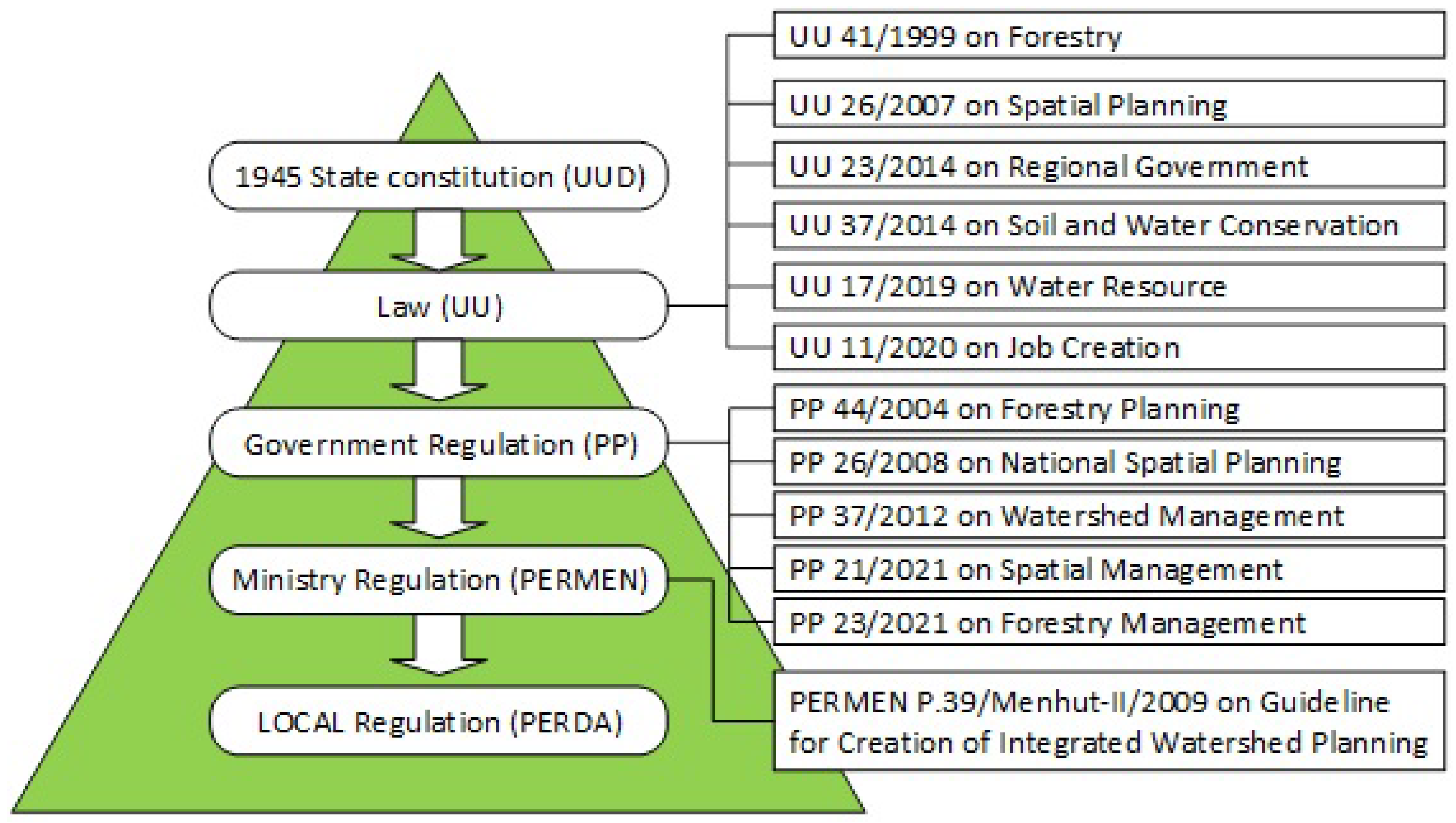
2.1. Rules Involved in Watershed Management

As the supreme rule, the 1945 State Constitution mandates: “Earth and water and the natural resources contained therein are controlled by the state and used for the greatest prosperity of the people” [38]. Various regulations from the articles in the Constitution have emerged and have become more dynamic in the last 10 years. There are several laws and their derivative hierarchies related to watershed management, as shown in Figure 2.
However, watershed management has not been operating successfully due to juridical constraints. In Indonesia, these constraints are related to hierarchical confusion and discrepancies among regulations, among other factors. An example is the confusion between Government Regulation No. 37/2014 on soil conservation and Law No. 37/2012 on watershed management. Substantially, soil conservation is part of watershed management activities. However, in the regulatory hierarchy, soil conservation is actually regulated by law, while watershed management is only regulated at the government level (Government Regulation No. 37/2012 concerning watershed management).
Another institutional problem related to watershed management regulation is the asynchrony between laws. Law No. 23/2014 concerning the regional government states that watershed management is the responsibility of the central government and provincial governments. The attachment to Law No. 23/2014 concerning the division of concurrent government affairs states that watershed management is the responsibility of the central and provincial governments [39]. Meanwhile, Law No. 37/2014 concerning water and soil conservation (promulgated in the same year), and Government Regulation No. 37/2012 concerning watershed management stipulate that watershed management from planning to implementation is not only the authority of the central and provincial governments but also the district government according to the watershed level. Other discrepancies in regulations related to watersheds are between Law No. 41/1999 (including its derivative regulations) and Government Regulation No. 26/2008 concerning national spatial planning, a derivative of Law No. 26/2007 concerning spatial planning. Government Regulation No. 26/2008 reduced the definition of protected forest and the criteria for determining protected forest as regulated in Law No. 41/1999, which contains objectives and criteria based on ecosystem sustainability only based on the criterion of geographic location to meet downstream needs.
The tendency to simplify the rules is also evident in the enactment of Law No. 11/2020 on job creation, which functions as an omnibus law [38]. This revised Law No. 41/1999 on forestry is related to the minimum forest area in a watershed or island [3]. Based on Law No.11/2020, the minimum forest area is no longer determined at 30% of the area of a watershed or island but is determined according to bio-geophysical conditions, environmental carrying capacity, watershed characteristics, and diversity of flora and fauna. Indeed, at the beginning of its emergence, various parties made strong criticism and suspected that ecological interests had been defeated by investment interests, which will potentially cause damage to watersheds, given that the restrictions are only based on debatable normative conditions [40,41,42]. The challenges should be addressed by all stakeholders responsible for the formulation of laws and regulations.
In addition to paying attention to formal legal aspects, watershed management also accommodates the development of relevant institutions rooted in local communities and closely related to customs, traditions, norms, and beliefs [37]. In Indonesia, traditional communities and indigenous peoples have wisdom in implementing aspects of watershed management. Some can be documented and taken into account in watershed management planning.

2.2. Institutions of Watershed Management

There are three types of organizations that are related to watershed management in Indonesia: government institutions formed under the mandate of laws and other regulations; institutions formed by the government based on the mandate of the law but whose members consist of NGO administrators, academics, researchers, and environmentalists; voluntary institutions formed by community members with their own awareness, who are actively involved in watershed management activities [35].
The Indonesian government established four ministries regarding government institutions and delegated watershed management to the provincial and district governments (Table 1).
The ministerial-level government organizations are responsible for formulating a national development plan, as well as coordinating and integrating sectoral development plans, including watershed management. Government Regulation No. 37/2012 requires the Ministry of Forestry to conduct interprovincial watershed management planning, establish a watershed information center in each province, establish a watershed observer forum, and monitor and evaluate watershed performance [3]. Based on the mandate of Law No. 17/2019, the Ministry of Public Works and Housing is responsible for developing management strategies for utilizing water resources, managing rivers, and controlling the destructive power of river water, managing irrigation and dams, swamps and lakes, and providing groundwater and raw water. Based on Law No. 23/2014 concerning regional government, provincial governments are mandated to manage watersheds in their administrative areas [39]. In fact, in the previous version of the regional government law, Law No. 22/1999, the watershed management mandate extended to the district and municipal levels [43], which is in line with the mandate according to Law No. 37/2014 concerning SWC.
Since the establishment of the Ministry of Forestry in 1983, watershed management activities have been run independently. The Directorate General of Reforestation and Land Rehabilitation under the Ministry of Forestry prepares a watershed management plan following the forestry sector watershed management plan, while the Ministry of Public Works prepares a river area management plan based on irrigation interests.
However, the scheme has been repeated since the issuance of Minister of Forestry Regulation No. 39/2009 concerning guidelines for preparing an integrated watershed management plan [3]. The integrated watershed management plan was ratified by a provincial regulation where a watershed is located. The Ministries of Forestry and Public Works formed a watershed management institution in each river basin. The Ministry of Forestry established the Management of Watersheds and Protected Forest Offices, and the Ministry of Public Works launched the River Basin Institution.
Law No. 17/2019 requires the Ministry of Public Works and Housing to establish an organization, the National Movement of Water Conservation Partnership [39]. This organization is located in the capital city (Jakarta), and each watershed has one sub-organization. Likewise, Government Regulation No. 37/2012 mandates that the Ministry of Forestry establish “watershed forums” in the capital city and each main watershed [3]. There is usually an overlap between the members of the two organizations, consisting of bureaucrats from two ministries, university lecturers, members of non-governmental organizations concerned with watershed management, and researchers. The purpose of establishing this organization was to provide policy input, advocacy, and control over watershed management activities carried out by the two ministries. However, because funding comes from the ministries, the function of the institution to control activities does not work properly due to mutual reluctance between the two institutions. One more organization related to watershed management activities, the Indonesian Soil and Water Conservation Society, was founded in 1998, consisting of bureaucrats, university lecturers, observers, and members of non-governmental organizations interested in soil and water conservation. The funding comes from the Ministry of Environment and Forestry, and this organization provides more policy input to that ministry. There are also several research and development institutions providing support for watershed management in Indonesia: Watershed Management Technology Center (WMTC), Center for Research and Development of Water Resources (CRDWR), and Center for Soil Research (CSR).
In practice, all of these institutions have carried out their respective duties, but unfortunately, there is still sectoral selfishness. Each sector developed a watershed management plan based on its own needs, and together they are difficult to harmonize; in fact, all parties are already aware of this weakness.
Regarding community involvement, the government stipulates that community participation in watershed management can be carried out by individuals or in the form of a coordination forum, which assists in supporting integrated implementation. The Ministry of Environment and Forestry states that the role of local communities, including customary law communities, in managing natural resources and the environment with practices of local wisdom is very important for the preservation of natural resources and the environment. Several local communities in Indonesia are actively conserving watersheds through forest protection management, such as the Batak people, who preserve the pine forests around Lake Toba, the people in Lampung, who protect the shorea forests, the Cidanau community, who preserve the Cidanau watershed, and people of Kampung Naga in the upper Ciwulan watershed, who have passed on norms and soil conservation systems from generation to generation [44,45,46].

3. Watershed Management Planning and Internalization in Regional Spatial Planning

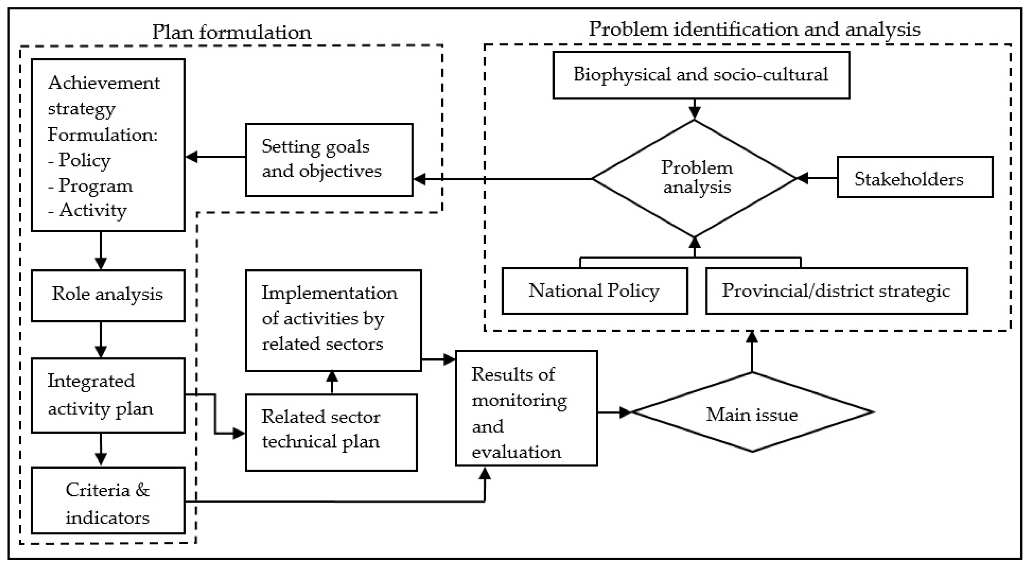
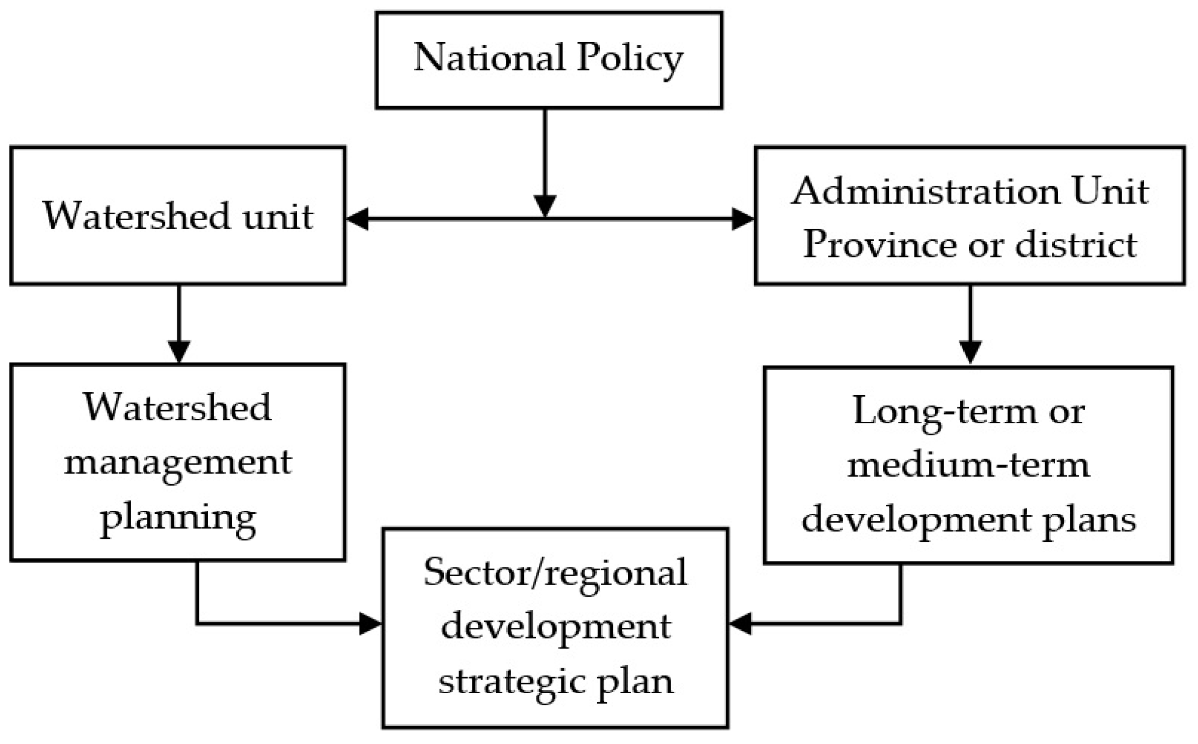
3.1. Watershed Management Planning Mechanism

Watershed management planning is natural resource development planning using watershed boundaries as the management units [6]. Planning is the initial stage of all management activities and is crucial in the development of an activity plan to improve watershed conditions. Based on Ministry of Forestry Regulation No. 60/2013, the management planning mechanism consists of two main stages: problem identification and analysis and plan formulation [3], as shown in Figure 3.
In implementing the planned watershed management activities, the ability and capacity of all stakeholders involved in the guidelines (Figure 3) must be improved so that the implementation can achieve the expected goals and objectives. Stakeholders are also expected to have the ability to identify and analyze problems as a consideration in the next watershed planning. The guidelines can be implemented if all parties are aware of the importance of integration in the implementation of watershed management. However, the implementation does not go well when there is a lack of communication, coordination, cooperation, policies, and regulations [31]. Watershed management planning mechanisms in Indonesia need to be developed by increasing the participation of all parties, both online and offline; improving the integration of plans from all sectors, government levels, and parties involved; clearly defining the responsible authority; and incorporating the plans in the provincial and district spatial planning. Although the ministry regulation guide integrates the plans of the central and local governments, in practice, the role of the central government is still dominant [36]. For example, the level of integration of the Garang watershed management still needs to be improved. In overcoming this problem, it is necessary to organize an integrated management plan, structure watershed boundaries with administrative areas, and maintain a clear separation of functions for each stakeholder in the management of this watershed [47].
Regarding regional development planning, as stated in Ministry of Forestry Regulation No. 60/2013, watershed management planning should be tiered at the national, provincial, and district levels, and finally at the micro or implementation level, as seen in Figure 4 [3]. The national watershed management plan should be downgraded to the provincial and district levels. Through the provincial planning agency, each provincial government can prepare a watershed management plan in its administrative area. Based on Law No. 23/2014, a district does not have watershed management authority, so the provincial government can delegate its authority to the Forestry Service Branch [39]. The mandates for implementing watershed management at the district level include determining the locations of micro watersheds, developing management plans, and implementing, monitoring, and evaluating the plans. The term of a watershed micromanagement plan is five years, divided into an annual plan that is expected to be used as a model for implementing watershed management.
Another influential factor in watershed management planning is community participation. In the future, watershed management planning should be carried out online so that all communities can provide feedback. This has been practiced by Colorado Natural Heritage (CNH), which developed a watershed planning toolbox. As an online mapping tool, the toolbox helps users visually monitor the distribution of rivers and wetlands, landscape ecological functions, and hydrological modifications, and prioritize conservation and restoration at the sub-watershed scale [48]. The planning must also adopt local wisdom so that the plan will be more readily accepted and applied by the community and be applied to environmental functions. These watershed management plans should use a bottom-up, not a top-down approach [49].

3.2. Internalization of Watershed Planning into Regional Spatial Master Plan (RTRW)

Spatial planning consists of all levels of land use, including decision-making aspects of structural-spatial elements. It is also a continuous process influenced by multi-sectoral policies. Spatial planning is carried out through coordination and integration of spatial policies and involves more complex institutions than spatial regulations [50]. Spatial planning in Indonesia, under what is known as a regional spatial master plan (RTRW), is established at the regional/sub-regional level and administrative boundaries. On the other hand, the rapid growth of the population and increasing economic and social activities in the watershed have led to an unfavorable impact on water management and environmental quality [51], including an increasing number of environmental disasters [52]. In several cases, land-use changes have not been in accordance with the environment’s carrying capacity [53], and spatial planning has not been appropriate to locations identified as prone to hydrometeorological disasters [54]. Therefore, there should be an internalization of watershed planning in the RTRW, which would consistently and continuously determine the sustainability of watershed management in the future.
Watershed management is cross-sectoral [55], multi-stakeholder, cross-administrative, and cross-disciplinary. Internalizing the watershed management plan into the RTRW simply means integrating the recommended programs/activities as planning input through a series of directed institutional coordination involving all parties [56,57]. Integration, coordination, synchronization, and synergy among stakeholders are needed to encourage program implementation to be more targeted and to ensure that overlapping activities do not occur. The detailed process of internalizing watershed planning into the RTRW consists of three stages: (1) ensuring spatial compatibility with regional functions, (2) assessing the impact, and (3) making recommendations [58]. This process also requires a leading sector that is responsible for data entry. At the moment, the leading sector is the Directorate of Watershed Management and Planning, Directorate General of Watershed Management and Protected Forest, Ministry of Environment and Forestry.
In carrying out the internalization process, there are several obstacles [59]: (1) there is a lack of understanding by and support from stakeholders in the implementation of the watershed management plan; (2) watershed data at the site level require detailed and accurate supporting data, and until 2020 the available data have not met the required technical requirements; (3) not all provinces/districts/cities have regional regulations (Perda) on watershed management; and (4) existing equipment in the field has not functioned optimally to support the evaluation of watershed performance. Reducing the constraints requires an analysis of the region’s specific characteristics and local conditions related to its demographic and geographic aspects. At the local level, the spatial planning system implements legally binding land-use plans and provides the basis for regulating development through development permit procedures. Buildings that are unsuitable for land use will be prohibited, and no permits will be granted [60].

4. Watershed Management Practices in Indonesia

A complex relationship exists in the watershed among its components of land, water, and people. Unsustainable management brings about watershed degradation, indicated by high erosion, sedimentation, and threatened availability of freshwater. Spatially, conditions and changes of upstream areas impact downstream areas, including mangrove and peatland ecosystems. Sustainable watershed management simply means managing the resources to optimize socioeconomic benefit, provide environmental services, and enhance ecological functions [61]. The following sections discuss watershed management practices in Indonesia in the context of prioritization of watershed/sub-watershed, arrangement of forest extent, vegetative and mechanical techniques for rehabilitation, essential downstream ecosystems (mangrove and peatland), and socioeconomic benefits and participation.

4.1. Prioritization of Watershed

Implementing watershed management programs in Indonesia involves significant financial, human resource, multi-sectoral stakeholder, and central or regional government commitment [62]. Therefore, it requires prioritization that aims to recognize the most appropriate watershed for more operative strategies [63,64]. Of the approximate 17,076 watersheds, 2149 are priority watersheds to be restored and 14,927 are to be maintained [65], based on the Ministry of Forestry Decree No. 60/2014. Priority categorization uses the carrying capacity of watersheds by weighting and scoring the parameters and indicators, i.e., land condition, water system, socioeconomic and institution, waterworks investment, and spatial utilization [62].
According to the approach used for watershed prioritization as decreed by law, it is necessary to pay attention to the data, methods, and scale. A lack of data availability is often encountered, especially data collected periodically, for example, streamflow for ungauged watersheds and sediment concentration. Data quality and suitability also become problems, since the data scattered in the various institutions have different standards [66]. More effort is required regarding alternative approaches for data limitations and managing data across institutions with uniform quality and standards. Remotely sensed data could be used as an alternative in the case of data gaps, such as quantification of surface water availability [67] and monitoring of rivers and lakes [68]. It can also deal with multiple sources/scales of temporal/spatial datasets, covering a broad range of geographic areas, and is cost-effective [69,70].
Concerning the methods, some have shortcomings in the context of watershed scale, for example, the use of the universal soil loss equation (USLE) to predict erosion. Numerous scientists have noted the weaknesses of the USLE: applying the model outside the model origin locus was often overestimated [71,72], the model does not reflect the process, and the model is suitable for site scale, not watershed scale [73]. Several hydrological-based simulation models have been developed to overcome the limitations of the USLE and address the limitations of hydrological data, especially for ungauged watersheds [74]. Previous studies in Indonesia utilized hydrological models to predict erosion and water yield at the watershed scale, such as the agricultural non-point source (AGNPS) [75], areal nonpoint source watershed environment response simulation (ANSWERS) [76], and soil and water assessment tool (SWAT) [15,77,78] models.
The scale is not clearly defined in the context of either the spatial data used or the watershed level (national, provincial, local/district). An equivalence scale of spatial data, such as base maps, thematic maps, and remotely sensed data, is critical in spatial analysis. Using different scales of spatial data leads to varying levels of information gain, details of spatial data, spatial scopes, and process degrees [79]. Therefore, using inequivalent data scales in spatial analysis brings inaccurate results, such as overgeneralization and loss of crucial information [80]. Essentially, defining an equivalent scale for both data and context is required, starting from the watershed prioritization preparation and data collection stages.
Furthermore, it should be acknowledged that watershed classification is expected to describe the level of urgency for watershed management at the national, provincial, and district/city scales. Therefore, sub-watershed prioritization of watersheds, especially large watersheds, also needs to be defined in more detail based on the central issues. Supporting research in determining priority sub-watersheds, including in Indonesia, has been widely carried out with different main problems using various parameters and methods. The main issues generally used as a starting point for determining the priority of sub-watersheds are erosion, sedimentation, and flooding. Regarding the criteria used, there are two main groups, biophysical and socioeconomic. Most studies have focused on biophysical parameters, such as geo-morphometrics and land use/land cover [63,81,82,83,84,85,86,87,88]. Various methods are available to integrate selected criteria for the prioritization of sub-watersheds. In general, four main groups of techniques have been implemented in the framework of GIS: ranking and scoring of criteria [6,66,89], statistical approaches [85,90], multi-criteria decision analysis (MCDA) [87,91,92], and a combination of all three approaches [63].

4.2. Extent of Forest Cover in Hydrological Behavior of Watershed

Indonesia has a total land area of about 190.48 million hectares, 63% of which is forest areas, or about 120.6 million hectares [93]. Based on the latest government regulation concerning forestry (No. 23/2021), the area of forest and forest cover that should be maintained in a watershed or an island is determined by considering biogeophysical conditions, environmental carrying, carrying capacity, watershed characteristics, and biodiversity [3]. This regulation replaces the old provisions, which stated that the total minimum area of forest coverage distributed proportionally has to be at least 30% in a given watershed area to secure ecological, economic, and social benefits for surrounding communities. The precise number of 30% forest cover had been adopted long before from Forestry Law No. 5/1967 [3]. However, its origin is unclear, and it is the subject of discussion among many scientists and forest hydrologists nowadays. It was reported that in 1920 (during the Dutch occupation), the government enacted a regulation mandating that 20% of Java should be forested to sustain the proper hydrological function [94].
For decades, the question regarding the proportion of forest cover sufficient in a particular watershed to achieve a healthy environment and keep up with sustainability goals has often perplexed policymakers and scientists. There is no accurate explanation; however, numerous plausible arguments have been well documented, together with long historical antecedents of forest hydrology research globally. It is also reasonably important to review the ranges of forest cover in other countries and to conduct observations to scrutinize all comparable references. Some examples of recent forest cover data are as follows: Indonesia: forest cover 46.46%, total land 190.48 million ha; European Union: forest cover 43.00%, total land 423.26 million ha; United States: forest cover 30.84%, total land 982.78 million ha; Australia: forest cover 19.00%, total land 774.12 million ha; Great Britain: forest cover 11.76%, total land 24.36 million ha; Brazil: forest cover 12.2%, total land 835.81 million ha; Malaysia: forest cover 0.05%, total land 32.86 million ha; Thailand: forest cover 0.40%, total land 51.09 million ha; and India: forest cover 1.80%, total land 297.32 million ha [95].
The importance of forest existing in a particular watershed can also be understood by analyzing the intrinsic value of forest ecosystem services, covering provisioning, regulatory, cultural, and supporting services. Practically, forest ecosystem services represent the conversion of a wide array of forest vegetation properties, such as woody perennial trees, undergrowth plants, annual plants, animals, microorganisms, carbon storage, and soil-water conservation, into services that support human well-being [96,97]. More specifically, as natural watersheds or catchments, forests are ecologically essential natural resources that regulate hydrological behavior, conserve soil and biomass carbon, and become the substrates of tremendous biodiversity [98,99,100].
Drawing conclusions from many studies on the hydrological impact on watersheds as affected by land-use changes in the country should be carried out carefully since in most cases there are two confounding factors: climate variability and forest cover change variability over time. However, observing this hydrological behavior is still important to describe essential natural phenomena related to the hydrological evidence in order to ensure water yield sustainability and conserve forested watershed ecosystem function under altered circumstances.
The surface of forested soil is humus-rich, accompanied by an upper mineral soil layer where soil particles are intimately incorporated with organic matter. This condition generates a porous soil surface that absorbs rainfall very swiftly. An old logged-over tropical forest in Malinau has a high infiltration rate of 99.5–100% of rainfall [101,102]. Generally, a high infiltration rate in such forest soil has been well documented [103,104,105,106]. This forest soil property is essential for soil and water conservation in a forested watershed. Peak flow, the maximum flow rate within a designated period, is another essential characteristic of hydrological impact in forested watersheds [107]. For example, pine forest cover in a watershed of about 33% could reduce peak flow by as much as 74%, compared to 13% for pine forest cover in Java [108]. Likewise, teak forest cover in a watershed of about 74% could control peak flow by 41% better than the 53% for forest cover [109].
In addition, another critical hydrological advantage of sustaining forest cover in watersheds is related to delivering the amount of water to support communal and industrial needs. Research on water yield production as influenced by extending forested watersheds has been reported with both negative and positive results [110]. This may be because the hydrological response to forest cover change is likely watershed-specific [111] and determined by watershed properties [112]. Reducing forest cover was shown to increase water yield, and the trend curve resembles a sigmoidal line [107,113]. The larger the pine and teak forest areas in the particular watershed, the lower the annual water yield produced in Java. Furthermore, an increase in teak forested watershed from 53% to 74% was associated with a decrease in water yield of 26–60% [108,109].

4.3. Watershed Rehabilitation through Vegetative Conservation

The aims of rehabilitating degraded watersheds are to improve diversity, increase the commercial value of wood and non-wood products, increase forest functions, and improve soil fertility [114]. Degraded watersheds should be rehabilitated, especially in upstream areas prone to degradation into critical land [115,116,117]. There are several degraded land in upstream areas due to forest conversions that are not in accordance with the land capacity [19,118,119]. In addition, public awareness of the importance of forest functions in the environmental system is still low [120].
Based on Ministry of Environment and Forestry Regulation No. 105/2018, rehabilitation of degraded watersheds in Indonesia is officially carried out through conservation activities, specifically forest and land rehabilitation (FLR), including vegetative conservation, mechanical soil and water conservation (SWC) practices, and community empowerment [3]. Several rehabilitation activities through vegetative conservation (forest plantation) have been carried out since the early 1950s, but the success rate is still low [121]. However, the government of Indonesia always tries to improve rehabilitation in degraded watersheds through programs such as forest rehabilitation (reforestation inside and outside forest areas) and community, urban, and mangrove forest rehabilitation. The latest data from the Ministry of Environment and Forestry show that degraded watershed rehabilitation each year from 2015 to 2019 amounted to 200,457, 198,346, 200,990, 188,630, and 395,169 ha, respectively, as shown in Table 2 [65]. Some suitable species, especially prominent trees species [122], as well as a combination of slow-growing and fast-growing species, drove reforestation success [123,124]. The more varied the vegetation planted, the higher the species diversity, which makes the ecosystem more stable. Besides that, vegetation greatly determines the ability of the soil to hold water [125]; therefore, it can prevent and control erosion.
Focusing on maximizing the involvement of and benefits for communities, the main choices of forest plantation programs in Indonesia are social forestry and agroforestry in the state forest and on private land, respectively. It has been recognized by many empirical studies that agroforestry has more benefits than monoculture patterns, in both ecological and economic aspects [126,127]. In addition, in Indonesia, other forms of vegetative rehabilitation patterns and their modifications have also been developed, such as silvopasture systems, alley cropping systems, contour hedgerows, and grass barriers [128,129,130,131].
There are many benefits of vegetative rehabilitation activities. The main benefit is that these activities significantly improve and expand forest cover areas, especially on open lands prone to degradation [132]. Increasing the forest cover will have an impact on improving the physical, chemical, and biological properties of the soil to become more stable against erosion and degradation [133,134,135,136,137]. Vegetative rehabilitation activities have also significantly increased people’s income and welfare [138,139,140] and support sustainable land management systems [127,141].
Based on many research results, some lessons have been learned from the implementation of vegetative rehabilitation in Indonesia towards the sustainability of watershed functions, which will affect the success of watershed rehabilitation programs. First, the adequacy of the rehabilitation site is the most important factor in achieving the goal of rehabilitating degraded land. Conducting a land capability analysis (LCA) and critical land mapping during site selection is crucial in watershed rehabilitation planning [22,142,143]. Second, land suitability analysis (LSA), cropping patterns, the market orientation of farm products, and community preferences must be considered in selecting appropriate species [142,144,145]. Third, community participation and integrated management are important keys to the sustainability of watershed rehabilitation implementation. The level of community participation will affect the performance of rehabilitation plants. Many cases in various regions show that vegetative rehabilitation is not successful due to weak community participation, especially post-planting maintenance activities [146,147]. Meanwhile, management integration, as manifested by collaborative activities between related parties and the community, can ensure the sustainability of rehabilitation programs [146,148].

4.4. Implementation of Mechanical Soil and Water Conservation Measure to Control Erosion and Sedimentation

Well-managed dry land in a watershed is the key to successful watershed management, especially in the upstream area [149]. Upstream areas with steep slopes that are managed as agricultural land will probably become prone to degradation [150]. The primary constraint of upstream areas in Indonesia is the weak application of soil and water conservation (SWC), which results in a high level of erosion and degradation [119,151]. Upstream areas function as buffers for downstream areas, so it is necessary to implement SWC properly. Long-term vegetative SWC strategies are frequently unable to overcome severe erosion. Implementing mechanical (civil engineering) SWC can be a rapid solution to overcome the severe erosion problems in the short term.
The principle of mechanical SWC is to reduce run-off and erosion and increase the soil’s functional ability. The implementation is divided into two targets. The first target is soil conservation (SC) measures to control erosion and sedimentation, such as check dams, gully plugs, and terraces. The second target is water conservation (WC) to minimize surface run-off and increase water infiltration, such as agriculture sewers, infiltration wells, infiltration ditches, and reservoirs (retention ponds) [3,152]. Naturally, differences in the goals and objectives will affect the choice of techniques and measures to be implemented. However, it is not easy to separate the objectives of soil and water conservation in many cases because they are interrelated.
Institutionally, the implementation of mechanical SWC is carried out by various parties based on the duties and functions of each institution/ministry [153]. For example, the Ministry of Environment and Forestry is responsible for constructing mechanical SWC measures to control erosion and sedimentation in upstream areas. The largest sediment control construction (a check dam) holds only up to 250 ha of the water catchment area. Wider catchment areas are under the authority of the Ministry of Public Works, which is usually combined with a water conservation building to distribute the agricultural and domestic freshwater. However, every ministry/party engaged in natural resources management has the task of carrying out conservation activities in its working area, both vegetative and mechanical.
Flood control is an essential concern in watershed restoration programs in Indonesia [154]. Flood control activities are carried out comprehensively from upstream to downstream of the watershed [155]. In upstream areas, efforts to implement SWC include mechanical measures, such as infiltration ditches and reservoirs, and revegetation to increase water infiltration and reduce surface run-off. In the middle area, infiltration wells and retention wells/ponds are mostly constructed to increase rainwater infiltration. Meanwhile, in downstream areas, check dams, river embankments, retention ponds, and polders are built to reduce flood waterlogging.
Implementing mechanical SWC measures such as terraces, infiltration ditches, and sewers can reduce surface run-off and erosion [156,157,158] and increase land productivity [157,159]. Gully prevention structures such as gully plugs and check dams are also significant in controlling run-off to reduce sedimentation to downstream areas [160,161,162]. Mechanical techniques to prevent landslides such as gabions, retaining embankments, and horizontal drainage drilling have improved slope stability and made the land more resistant to landslides [163,164]. The construction of water conservation measures such as infiltration wells, reservoirs, and check dams is useful in increasing infiltration, controlling run-off, and providing raw water for agriculture, livestock, and domestic use [165]. Simulations of water conservation measures in the upstream and middle areas of the Ciliwung watershed include infiltration wells, bio-pores, check dams, and infiltration ditches, which can reduce flooding in Jakarta by around 34% [166].
Several points can be formulated with regard to the challenges for further implementation of mechanical SWC in Indonesia. First, its success is influenced by accurately identifying erosion problems in the field. Therefore, mechanical SWC planning must be carried out through a bottom-up approach. Second, the failure of mechanical buildings to carry out their conservation functions is influenced by errors in the construction process and weak post-construction maintenance [167]. Likewise, evaluations of the effectiveness of SWC constructions need to be carried out to obtain feedback for future planning [161]. Moreover, the sustainability of the mechanical SWC programs is strongly influenced by community participation [158]. The problem of limited funding can be overcome by collaboration between parties on the implementation (a cost-sharing mechanism). Capacity building to increase community knowledge helps in early recognition of problems with the land or utilizing local materials for SWC construction, such as bamboo [168].

4.5. Downstream Essential Ecosystem Management

4.5.1. Peatland Management

In general, tropical peatlands in Indonesia, such as in Sumatra, Kalimantan, and Papua, lie downstream of watersheds. The ecological function of peatland is to regulate hydrological aspects such as water storage, water supply, and flood control [169]. Peatland has a reversible drain characteristic; it absorbs water when the overland flow is abundant, and it functions as a water source in dry seasons. Reversible drying is strongly related to the peat-like characteristics of giant sponges, which are flexible, wet, and closely affected by land cover. The thicker the land cover, the lower the risk of being burnt and dry. Physical, chemical, and biological characteristics are significant in peatland hydrology [170]. These characteristics develop with peat vegetation and rain/river/seawater supply, resulting in fragile peatland. Thus, to understand peatland management, a good understanding of the peatland hydrological system is needed.
Peatland in Southeast Asia is degrading due to logging, conversion into other land uses, especially industrial plantations, drainage, and fires [171,172,173]. As an example, in Central Kalimantan in 1995, the government of Indonesia initiated a peatland development project to convert 1 million ha of peat and lowland swamp into rice fields [174,175], known as the Mega Rice Project (MRP). More than 4000 km of canals were built, including primary, secondary, and tertiary canals [174]. Studies [169,174,176] showed that drainage canals within the peatland increased surface run-off and reduced the capacity of peat water storage, resulting in a disturbance of the peatland hydrological balance. The peat domes were cut through by canals, resulting in excessive drainage, peat subsidence, irreversible drying, and increased fire frequency and severity [177].
The first effort to restore the hydrology in Block A of the ex-MRP area was the construction of dams by international NGOs [178]. To block illegally dug canals in Sebangau National Park, another NGO built many of the same type of dam within four years (2005–2009); 176 dams were constructed, which successfully increased the water table of Sebangau peatland [169,174]. To date, the national park management has constructed 1831 canal blockings to conserve the Sebangau peat [179].
The year 2015 marked Indonesia’s worst forest and land fire in 18 years [180]; it occurred from June to November, burning 2.6 million hectares of land. Along with the smoke and haze causing health problems, the World Bank recorded an estimated loss of IDR 221 trillion [181]. In all, 962,000 hectares, or 37% of the 2.6 million hectares of burnt land, were peatlands. To prevent further peatland degradation, the government of Indonesia established the Peatland Restoration Agency (Badan Restorasi Gambut (BRG)), responsible for coordinating and facilitating peatland restoration. The restoration target was set as 2 million hectares from 6 January 2016 to 31 December 2020 using three approaches: rewetting, revegetation, and revitalization of local livelihood (known as 3R).
Rewetting has been carried out to rewet drained peatland by constructing infrastructure such as canal blockings, canal backfillings, and deep wells. Revegetation is carried out by planting local peatland species to enhance the vegetation cover. Revitalization is aimed at maintaining the sustainability of economic revitalization in the community and raise awareness of peatland restoration. Up to 2018, BRG constructed 11,800 deep wells, 5936 canal blockings, and 242 canal backfillings [180]. Moreover, BRG claimed an estimated area affected by rewetting activities of 679,901 hectares or 62% of the total target. As many as 713 revegetation demonstration plots were planted in Riau, Jambi, South Sumatra, South Kalimantan, and Central Kalimantan Province. In terms of revitalization, it cooperated with 530 community groups, or 7950 people, for community livelihood activities. Various stakeholders also restored the hydrological properties of drained peatland in Central Kalimantan, South Sumatra, Jambi, and Riau [182,183,184]. Despite these positive efforts, the rewetting activities implemented used the trial-and-error approach [185].
Furthermore, to manage the watersheds in Indonesian peatlands, hydrological restoration implementation should be based on good planning, proper technical interventions, and proper monitoring and evaluation. In terms of revegetation and revitalization, tree site-species matching should be determined. At the same time, the community’s livelihood in the area should also be considered for the success of peatland restoration. The selection should be based on species that are tolerant to water-logged conditions and have high economic value to support the community’s livelihood. Involving communities is key to the success of peatland restoration in Indonesia.

4.5.2. Mangrove Management

Mangrove ecosystems are located downstream of watersheds and can be found in deltas where rivers flow into the ocean, in estuaries or lagoons, or along open coastlines [186]. This type of ecosystem has strong linkages with its surrounding hydrology and is influenced by freshwater and seawater exchange [187,188]. Recharge from upstream rivers, precipitation, and surface run-off are freshwater inputs that enter mangrove ecosystems, while oceanic inputs are controlled mainly by tides [188]. As an ecosystem influenced by hydrogeological factors, mangroves can function as natural filtration between land and coastal waters. As a result, they can improve water quality by serving as a buffer for pollutants, nutrients, and toxic contaminants before these can enter coastal habitats [189].
Mangrove loss in Indonesia increased rapidly in 1970, expanding from Java and Sumatra to Kalimantan, supported by government policies to increase timber production and aquaculture development. Mangrove timber production started where the provincial government had the authority to issue forest concession permits regardless of the concessions area. Since 2003, the leasing of mangrove forest extraction has been administered by the Ministry of Forestry, with a 30-year leasing period [190]. To date, three mangrove concession companies are running in Papua and West Kalimantan. Timber exploitation is also conducted by communities or individuals living around the mangrove forests for timber and firewood [191].
On the other hand, aquaculture has been a significant driver of mangrove deforestation in Indonesia, contributing 48.6% to the total in 2000–2012 [192]. Studies have shown that mangrove loss leads to many ecological impairments, such as biodiversity and economic losses [189]. Another important impact of the conversion of mangrove to aquaculture is the massive greenhouse gas emissions generated due to the loss of the mangrove’s carbon stocks and sequestration capacity [193,194,195].
Mangrove conservation includes activities to maintain and protect the ecosystems by designating a proportion of undisturbed mangrove areas as conservation and green belt areas [190,196]. To date, the Ministry of Environment and Forestry has established 13 mangrove ecosystem essential (MEE) areas important for biodiversity conservation [197]. Managing MEE areas must include protecting and preserving biodiversity and ecosystems and using the area’s potential based on existing ecosystem services. Since 2010, the government has focused on reforestation programs to restore the degraded mangrove areas; implementations include sylvo-fisheries (managing mangroves with aquaculture practices), intensive mangrove planting in degraded areas, and community nurseries. In 2020, the Ministry of Environment and Forestry replanted more than 17,000 ha of mangroves to provide job opportunities for local communities during the COVID-19 pandemic. Based on Presidential Regulation No. 120/2020 on the peatland and mangrove restoration agency [38], a stronger commitment by the government to restore mangrove ecosystems is indicated by an ambitious target to replant 600,000 ha of mangroves across Indonesia in 2021–2024. To ensure the success of mangrove reforestation programs, ecological requirements should be considered by planting suitable species in the appropriate zones. Involving communities, promoting collaboration among relevant stakeholders, and strengthening local mangrove governance in a sustainable manner by ensuring integrated planning and management between land and marine ecosystems would constitute a critical success in mangrove management.

4.6. Socio-Economic Benefits and Participatory Watershed Management

Services produced by the characteristics, functions, and ecological processes of watersheds become a support system for human life and the earth’s ecosystem [198]. Water affects the culture, livelihoods, and economy of the community. For people on large islands with many rivers, such as the Sumatra and Kalimantan Islands, the existence of rivers influences cultures, such as in settlements, transportation systems, natural resource extraction, and cultivation. The identity and existence of settlements, transportation, and water sources in Banjarmasin City, South Kalimantan Province, are influenced by the Barito River [199]. Meanwhile, the pattern of settlements is influenced along the Musi River in South Sumatra [200]. Rivers also influence settlement and transportation systems of the Bakumpai Tribe in Central Kalimantan, East Kalimantan, and South Kalimantan [201] and the Besemah Tribe in South Sumatra [202].
Water also has economic benefits that can be assessed in monetary terms. Several studies show the economic value of water in sub-watersheds in the highlands and lowlands, including peatlands. The economic value of water in the Perapau sub-watershed in the highlands of South Sumatra for household and agricultural purposes is USD 128,905 million and 832,187 per year, respectively [203]. The economic value of water from Bantimurung Bulusaraung National Park in Sulawesi is USD 144.3 million per year for the surrounding community and USD 10.4 million for the local government [204]. The economic value of water from the Merang Kepayang peat swamp forest (South Sumatra) is USD 530 per hectare [205]. Research on the economic value of water shows that water has a monetary value that is not inferior to other commodities.
Several facts show that a major part of forest management problems, as a component of watershed management, can be solved when local people are empowered to participate. Therefore, participatory watershed management is a promising approach to benefit from sustainable watersheds [206,207]. The following two success stories of participatory practices at the site level could be used to improve watershed management.
The Semende community in the upper Musi watershed, South Sumatra, has a key element that has led to a sustainable forest–sawah relationship. The sawah (rice field) is the main symbol of the life of the peasant community, with the upstream forest as one of the characteristics. It is designated as a social mechanism that becomes an integral package to ensure forest and watershed sustainability [208]. Meanwhile, strong motivation and active collective participation driven by shared awareness and interests have become social capital that encourages participation by the Muara Baimbai community in managing an area downstream of the Sialang Buah watershed in North Sumatra [209]. These are two examples of community management with a strong social and cultural capital in forest areas in watersheds. Watershed management with community participation is key to inclusive and participatory management. Referring to the ladder of participation, this type of management can be carried out if there is a high level of participation by the community, where power is distributed through negotiations between citizens and power holders. In this position, the community will actively encourage strong motivation, work allocation, fair profit sharing, strong internal ties, and extensive networks to strengthen social capital [210].
One of the success stories of increasing collective community participation through improving welfare is the development of micro-hydropower (MHP). The ultimate goals of MHP development are to raise the incomes of forest villagers and ensure that they are empowered and have the ability to manage their resources. From forest management interests, the development of MHP can be used as an instrument to enhance community participation in protecting and preserving the function of the forest.
The development of participatory-based micro-watershed management through MHP incentives was initiated by Environment and Forestry Research and Development Institute Makassar (BP2LHK) in three sub-villages (Singgang-Katimbang, Kayu Biranga, and Na’na) of Borongrapoa Village, Bulukumba Regency, in 2014. At this location, MHP is developed in what is known as a cascade micro-hydro system. The term cascade is used to describe two things: the physical design and the process of development. From the physical aspect, the term cascade explains the multiple uses of a single streamflow to develop series of MHP units sequentially from upstream to downstream. In terms of process, the term describes the sequential development process of MHP.
The success of the first unit of participatory MHP inspired and triggered the development of the next units. This series of MHP units were developed in a single stream for the three communities to empower collective participation: three different physical conditions and turbine specifications for three different socioeconomic characteristics of communities. By being directly involved in MHP development, people have a valuable experience, thus enhancing their knowledge. Through a competitive approach, people easily understand the correlation between water discharge and the resulting electricity capacity. Villagers know that the condition of the forest and water yields will determine the quantity, quality, and continuity of the forest benefits they can obtain. In addition, the competitive approach to make the MHP development and management more successful than other groups has stimulated the spirit of communal participation through fair competition. In the third year after the MHP units were built, when the management institution had started to run well, the electricity generated was then used to drive small industries (productive use of energy), the implementation of which was aided by several parties, both in terms of providing tools and institutional assistance.
Based on the two cases, the essential element of participatory watershed management is strengthening public awareness about the importance of maintaining and preserving watershed resources to ensure continuous watershed goods and services. Indeed, the study shows that regarding institutional and physical efforts to increase community participation, a transparent planning and implementation process is key to success. Participation will only happen when there is trust. It is impossible to gain trust without real transparent information. Transparency not only increases efficiency in resource allocation, but also enables a fair distribution of benefits [211,212,213,214]. Community participation in watershed management will occur when there is guaranteed access to watershed resources to fulfill people’s needs.

5. Monitoring and Evaluation of Watershed Management Performance

Achieving a sustainable watershed shows the success of natural resource management. Monitoring and evaluation are critical tools to provide valuable information on watershed management achievement in terms of a real sense of the output. The aim is to determine the watershed health level, which is the basis for deciding management planning for the next period [215].
The Minister of Forestry Regulation regulates monitoring and evaluation of watershed management based on two aspects: socioeconomic (including socioeconomic and building investment criteria) and environmental sustainability (including land, water management, and space utilization criteria). Each criterion consists of several sub-criteria, each of which has a weight, value, and score. The carrying capacity of the watershed is the sum of multiplying the total weight and score of all criteria/sub-criteria [3]. An evaluation framework is used to assess whether the watershed management objectives are in line with expectations. It is comprehensive and practical for monitoring and evaluating watershed management performance in the context of criteria and calculation methods. Regarding the criteria/sub-criteria for monitoring and evaluation activities, they are quite complex and sometimes difficult to implement in the field. Therefore, the criteria should be simplified in order to make monitoring and evaluation easier, cheaper, and faster, but also scientifically acceptable [216]. The criteria for watershed sustainability in Indonesia and other countries can be seen in Table 3.
Research suggests the use of three indicators: land cover index, land management index, and soil conservation practices [216]. Regarding the hydrological parameters, simpler parameters are proposed for evaluation by reducing the number from the 13 stated in the regulations to only five parameters. The study found a high correlation between several water quality parameters, such as biochemical oxygen demand (BOD), chemical oxygen demand (COD), potassium permanganate (KMnO4), and NO2 [221].
The criteria/sub-criteria in the Ministry of Forestry regulations could be used partially, depending on the site-specific issues and watershed scale, such as a carrying capacity evaluation of the Brantas watershed. In this watershed, an evaluation was based on water management sub-criteria including flow regime coefficient, annual flow coefficient, sediment load, flood frequency, and water usage index [222]. In of Unda watershed, assessment was based on land sub-criteria (critical land, percentage of vegetation cover, and erosion index) and water management sub-criteria [223]. Socioeconomic sub-criteria (population pressure on land, population welfare level, existence, and enforcement of rules) were used to evaluate the socioeconomic conditions of Brantas [224] and Moyo [225] watersheds. These studies concluded that the use of sub-criteria could partially explain each aspect’s conditions and problems (land, water management, and socio-economic) as the basis for determining management plans for the future.
Participation as a means of applying the bottom-up approach is another crucial part of the monitoring and evaluation system [226]. Participatory monitoring and evaluation of watershed performance mean all the processes are integrated [227]. Stakeholder participation in the process could be more effective in terms of the cost. It would also build awareness and technology transfer among stakeholders. Each stakeholder monitors and evaluates the related criteria and sub-criteria according to their tasks and responsibilities. For example, the requirements for land and space utilization are monitored by the Ministry of Environment and Forestry, water management and building investment criteria by the Ministry of Public Works, and socioeconomic criteria by the Ministry of Agriculture. Besides the formal stakeholders, the involvement of informal stakeholders could strengthen watershed management accountability and ensure that the management objectives align with stakeholders’ needs.
In the temporal context, monitoring and evaluating watershed management might need to be a long-term effort that requires scientific research. It takes a long time for the impacts and benefits to be established when watershed management programs are implemented. Monitoring and evaluation systems have to obtain and track the fluctuations of effects over time. Therefore, the contribution of scientific research has to be set up for the long term and become the responsibility of public institutions [226]. The relationship between research and public institutions in charge of monitoring and evaluating watershed management is very close because the parameters and threshold values that are determined are obtained from research findings. Although the impact of watershed management implementation can only be seen in the long term, short-term evaluations need to be carried out to see the trend in the direction of the objectives. In addition, short-term evaluation is also used to assess whether the plans that were prepared need to be adjusted.
Monitoring and evaluation systems also have to adapt to technological advances that can collect, analyze, and interpret results. The development and advancement of Geographic Information Systems (GIS), remote sensing (RS), modeling, and computer systems have made monitoring and evaluation more effective, more cost-effective, and less time-consuming. They also derive data and information more accurately with high resolution, both spatial and temporal, such as watershed characteristics and changes in land use/land cover [228]. On the other hand, modeling of watershed systems provides a comprehensive understanding of the processes within the watershed, especially the hydrological process, the relationship between biophysical and anthropogenic entities, and the linkage of upstream and downstream. These technologies are powerful tools to compensate for the limited data and information often encountered in most watersheds of developing countries, including Indonesia [229]. However, the use of a hydrological model requires accurate input of data. Advances in computer and information technology can be utilized for monitoring and evaluation systems. Satellite imagery will make it easier and cheaper to collect data for monitoring and evaluation of watershed management, especially data on land cover, rainfall, and flooded areas. In the future, monitoring and evaluating watershed sustainability should be conducted online so that everyone can have equal access. For example, the Ministry of Public Works monitors river discharge online, on the website www.tech4water.com (accessed on 3 August 2021). Monitoring river water quality also needs to be added, because pollution in rivers is expected to increase in the future. Apart from analyzing water quality, pollution indicators in rivers can also be developed by identifying aquatic biota. By identifying water biota, local communities can also play a role in monitoring river water quality.

6. Conclusions

Indonesia has a long history of watershed management, but its implementation requires further work to achieve sustainability. A sustainable watershed begins with management institutions formed with a bottom-up approach, starting from the local community and working up to the national level. Its effectiveness is supported by the availability of regulations in every management aspect. However, Indonesia’s juridical aspects of watershed management involve hierarchical confusion, discrepancy, and asynchrony among regulations. The obstacles should be gradually overcome with the issuance of new laws that will guide environmental legislation. The challenges should be addressed by all stakeholders responsible for the formulation of laws and regulations.
In watershed management, institutions are a very important factor. Watersheds must be managed with a complex ecosystem approach and involve a multi-institutional, multi-actor, and cross-border focus (administration and ecosystem). With multiple stakeholders, participation, synchronization, and coordination are important keys in improving the watershed management institution, especially in Indonesia. Watershed management planning does not run well due to a lack of communication, coordination, cooperation, policies, and regulations. To overcome the problem, the participation of all parties should be increased, the integration of plans from all sectors, government levels, and parties involved should be improved, the watershed management authority should be clearly defined, and a management plan should be incorporated into provincial and district spatial planning.
In accommodating community participation and local community wisdom, the mechanism of watershed management planning should use a bottom-up approach and be carried out online to obtain broad feedback. Internalizing watershed planning within regional spatial planning often encounters obstacles due to a lack of understanding and support from multiple stakeholders and limitations with regard to the required supporting data and field instruments. Analyzing the region’s specific characteristics and local conditions related to demographic and geographic aspects is required to minimize this constraint.
The implementation of watershed management programs in Indonesia involves significantly limited resources. Watershed prioritization is an effort that is being pursued even though there are still constraints due to data gaps. This situation can be addressed by using remotely sensed data and applying hydrological-based simulation models. The bridging of data gaps is also needed to determine the effect of forest cover on the hydrological behavior of a particular watershed. These related studies are becoming important, because the hydrological merit of sustaining forest cover in watersheds is related to delivering the amount of water needed to support communal and industrial needs.
Watershed degradation is often the result of forest cover conversion and land utilization that is not in accordance with the land capacity. It will bring disaster and severe land damage. The implementation of degraded watershed rehabilitation in Indonesia towards the sustainability of watershed functions has been carried out with vegetation and mechanical constructions. Better results should be obtained with adequate information on degraded watershed characteristics, the use of appropriate species and mechanical construction, and most importantly, community participation. Watershed degradation, especially in downstream areas, is also often caused by the conversion and excessive utilization of peatland and mangroves. To prevent further peatland degradation, the restoration target was set at 2 million hectares using rewetting, revegetation, and revitalization of local livelihoods. This approach should improve the ecological conditions, pay attention to economic community aspects, and raise awareness of peatland restoration. To minimize the restoration failure, the implementation should proper technical interventions for rewetting and the selection of species tolerant to water-logged conditions with high economic value to support the community’s livelihood. For mangrove reforestation programs, ecological requirements should be considered by planting suitable species in the appropriate zones. Community involvement, collaboration among stakeholders, and strengthening local mangrove governance in a sustainable manner would mean critical success in mangrove management.
Based on the success stories presented here, the essential element of participatory watershed management is strengthening public awareness and trust regarding the importance of a sustainable watershed. Guaranteed access to watershed resources and community involvement in transparent planning and implementation processes are the keys to increasing community participation. In assessing the achievement of watershed management, monitoring and evaluation are conducted based on socioeconomic and environmental aspects. The criteria used are quite complex and sometimes difficult during implementation due to a lack of appropriate data. Simplified criteria could be used, depending on the site-specific issues and watershed scale. Data limitations can be overcome with the use of hydrological models and satellite images, and community involvement by developing online methods. Furthermore, research is still needed to strengthen the policies for effective institutions, community participation, successful rehabilitation, simplified criteria for monitoring and evaluation, and fulfillment of essential data in every aspect of watershed management.

Author Contributions

B.H.N., C.A.S., I.W.S.D., A.S., P. (Pratiwi), I.B.P., T.M.B., H.Y.S.H.N., A.B.S., P. (Purwanto), O.S., R.N., N.A.U., V.B.A. and T.W.Y. had an equal role as main contributors who equally discussed the conceptual ideas and the outline, provided critical feedback on each section, and helped shape and write the manuscript. All authors have read and agreed to the published version of the manuscript.

Funding

This research received no external funding.

Institutional Review Board Statement

Not applicable.

Informed Consent Statement

Not applicable.

Data Availability Statement

Not applicable.

Acknowledgments

We thank anonymous reviewers for their detailed comments and corrections.

Conflicts of Interest

The authors declare no conflict of interest.

References

  1. Minister of Environment and Forestry. Road Map of Sustainable Development Goals; Ministry of Environment and Forestry: Jakarta, Indonesia, 2018.
  2. Sheng, T.C. Watershed management field manual. Watershed survey and planning. In FAO Conservation Guide; Food and Agriculture Organization of The United Nations: Rome, Italy, 1990. [Google Scholar]
  3. Jaringan Dokumentasi dan Informasi Hukum Kementerian Lingkungan Hidup dan Kehutanan. Available online: https://jdih.menlhk.co.id (accessed on 12 July 2021).
  4. Reddy, V.R.; Saharawat, Y.S.; George, B. Watershed management in South Asia: A synoptic review. J. Hydrol. 2017, 551, 4–13. [Google Scholar] [CrossRef]
  5. Wang, G.; Mang, S.; Liu, S.; Zhang, Z.; Wang, L.; Innes, J.L. Integrated watershed management: Evolution, development and emerging trends. J. For. Res. 2016, 27, 967–994. [Google Scholar] [CrossRef] [Green Version]
  6. Paimin; Pramono, I.B.; Purwanto; Indrawati, D.R. Sistem Perencanaan Pengelolaan Daerah Aliran Sungai; Pusat Penelitian dan Pengembangan Konservasi dan Rehabilitasi: Bogor, Indonesia, 2012. [Google Scholar]
  7. Montgomery, D.R.; Grant, G.E.; Sullivan, K. Watershed analysis as a framework for implementing ecosystem management. JAWRA 1995, 31, 369–386. [Google Scholar] [CrossRef]
  8. deSteiguer, J.E.; Duberstein, J.; Lopes, V. The Analytic Hierarchy Process as a means for integrated watershed management. In Proceedings of the Integrating Science with Watershed Decision Making II, Conference Proceedings of First Interagency Conference on Research in the Watersheds, Benson, AZ, USA, 27–30 October 2003; pp. 736–740. [Google Scholar]
  9. McDonnell, J.J.; Sivapalan, M.; Vache’, K.; Dunn, S.; Grant, G.; Haggerty, R.; Hinz, C.; Hooper, R.; Kirchner, J.; Roderick, M.L.; et al. Moving beyond heterogeneity and process complexity: A new vision for watershed hydrology. Water Res. Res. 2007, 43, 1–6. [Google Scholar] [CrossRef] [Green Version]
  10. Badan Perencanaan Pembangunan Nasional. Kaji ulang RAN API: Kajian Basis Ilmiah Proyeksi Iklim Atmosferik; Bappenas: Jakarta, Indonesia, 2018.
  11. Kementerian Lngkungan Hidup dan Kehutanan. Informasi Daya Dukung dan Daya Tampung Air Nasional; KLHK: Jakarta, Indonesia, 2019.
  12. Balai Penelitian dan Pengembangan Teknologi Pengelolaan Daerah Aliran Sungai. Available online: https://balitekdas.id/profil (accessed on 3 August 2021).
  13. Qomarun; Prayitno, B. Morfologi Kota Solo. Dimens. Tek. Arsit. 2007, 35, 80–87. [Google Scholar]
  14. Riwu-kaho, M.; Mella, W.I.I.; Mau, Y.S.; Riwu-kaho, N.P.L.B. Water balance analysis of Talau-Loes Watershed, a cross border watershed of Indonesia and East Timor. Trop. Drylands. 2020, 4, 17–24. [Google Scholar] [CrossRef]
  15. Nandini, R.; Kusumandari, A.; Gunawan, T.; Sadono, R. Assessment of land use impact on hydrological response using Soil and Water Analysis Tool (SWAT) in Babak watershed, Lombok Island, Indonesia. Agric. Nat. Resour. 2019, 53, 635–642. [Google Scholar] [CrossRef] [Green Version]
  16. Somura, H.; Yuwono, S.B.; Ismono, H.; Arifin, B.; Fitriani, F.; Kada, R. Relationship between water quality variations and land use in the Batutegi Dam Watershed, Sekampung, Indonesia. Lakes Reserv. 2018, 24, 93–101. [Google Scholar] [CrossRef] [Green Version]
  17. Susanti, Y.; Syafrudin, S.; Helmi, M. Soil Erosion Modelling at Watershed Level in Indonesia: A Review. In Proceedings of the 4th International Conference on Energy, Environment, Epidemiology and Information System (ICENIS 2019), Semarang, Indonesia, 7–8 August 2019; E3S Web of Conferences: Les Ulis, France, 2019; Volume 125, p. 01008. [Google Scholar] [CrossRef]
  18. Setyawan, C.; Susanto, S.; Lee, C. Land and water conservation practices in tropical agricultural watershed. J. Degrade. Min. Lands. Manag. 2019, 6, 1697–1704. [Google Scholar] [CrossRef] [Green Version]
  19. Barchia, M.F.; Amri, K.; Apriantoni, R. Land degradation and option of practical conservation concepts in Manna Watershed Bengkulu Indonesia. TERRA 2018, 1, 23–30. [Google Scholar] [CrossRef]
  20. Mahmud; Kusumandari, A.; Sudarmadji; Supriyatno, N. A study of flood causal priority in Arui Watershed, Manokwari Regency, Indonesia. J. Manaj. Hutan Trop. 2018, 24, 81–94. [Google Scholar] [CrossRef]
  21. Pambudi, A.S. System dynamics modelling of deforestation rate and forest rehabilitation in the upstream of Ciliwung Watershed, Bogor Regency. Indones. J. Dev. Plan. 2020, 4, 327–346. [Google Scholar] [CrossRef]
  22. Wahyuningrum, N.; Basuki, T.M. Analisis kekritisan lahan untuk perencanaan rehabilitasi lahan DAS Solo bagian hulu. J. Penelit. Pengelolaan Drh. Aliran Sungai 2019, 3, 27–44. [Google Scholar] [CrossRef]
  23. Sulistyo, B.; Gunawan, T.; Danoedoro, P.; Martanto, R. Proposed models on level of degradation at Merawu watershed, Banjarnegara Regency, Central Java Province, Indonesia. Bioptropia 2017, 2, 220–229. [Google Scholar] [CrossRef]
  24. Barchia, M.F.; Sulistyo, B.; Hindarto, K.S.; Suhartoyo, H. Assessment of Air Bengkulu (Indonesia) watershed based on agroecosystem landscape quality and sustainable land use plan. Biodiversitas 2020, 21, 5422–5430. [Google Scholar] [CrossRef]
  25. Siswanto, S.Y.; Francés, F. How land use/land cover changes can affect water, flooding and sedimentation in a tropical watershed: A case study using distributed modelling in the Upper Citarum watershed, Indonesia. Environ. Earth Sci. 2019, 78, 1–15. [Google Scholar] [CrossRef]
  26. Astuti, I.S.; Sahoo, K. Impact of land use land cover (LULC) change on surface runoff in an increasingly urbanized tropical watershed. Water Resour. Manag. 2019, 33, 4087–4103. [Google Scholar] [CrossRef]
  27. Muis, B.A. Land use planning for water resource conservation in the Krueng Aceh watershed, Indonesia. AES Bioflux 2019, 11, 67–74. [Google Scholar]
  28. Cohen, A.; Davidson, S. The watershed approach: Challenges, antecedents, and the transition from technical tool to governance unit. Water Alt. 2011, 4, 1–14. [Google Scholar]
  29. Fulazzaky, M.A. Challenges of integrated water resources management in Indonesia. Water 2014, 6, 2000–2020. [Google Scholar] [CrossRef] [Green Version]
  30. Ariyani, N.; Ariyanti, D.O.; Ramadhan, M. Pengaturan ideal tentang pengelolaan daerah aliran sungai di Indonesia (Studi di Sungai Serang Kabupaten Kulon Progo). J. Huk. Ius Quia Iustum 2020, 27, 592–614. [Google Scholar]
  31. Waskitho, N.T.; Pratama, A.A.; Muttaqin, T. Sectoral integration in watershed management in Indonesia: Challenges and recomendation. IOP Confrence Series: Earth. Environ. Sci. 2021, 752, 012035. [Google Scholar] [CrossRef]
  32. Sriyana, I. Indeks stakeholders pengelolaan daerah aliran sungai dengan pendekatan KISS di Indonesia. Media Komun. Tek. Sipil 2018, 24, 79–86. [Google Scholar] [CrossRef]
  33. Pambudi, A.S. Watershed management in Indonesia: A regulation, institution, and policy review. Indones. J. Dev. Plan. 2019, 3, 185–202. [Google Scholar] [CrossRef]
  34. Suparwata, D.O. Pengelolaan Rehabilitasi Lahan Kritis berdasarkan Partisipasi Masyarakat di DAS Randangan Kabupaten Pohuwato (Critical Land Rehabilitation Management Based on Community Participation in Randangan Watershed, Pohuwato District). In Pengembangan Ilmu dan Teknologi Pertanian Bersama Petani Lokal untuk Optimalisasi Lahan Suboptimal, Prosiding Seminar Nasional Lahan Suboptimal, Palembang, Indonesia, 18–19 October 2018; Universitas Sriwijaya: Palembang, Indonesia, 2018; pp. 978–979. [Google Scholar] [CrossRef]
  35. Kartodihardjo, H.; Murtilaksono, K.; Sudadi, U. nstitusi Pengelolaan Daerah Aliran Sungai; Konsep dan Pengantar Analisis Kebijakan; Fakultas Kehutanan Institut Pertanian Bogor: Bogor, Indonesia, 2004. [Google Scholar]
  36. Sulistyaningsih, T.; Nurmandi, A.; Salahudin, S.; Roziqin, A.; Kamil, M.; Sihidi, I.T.; Romadhan, A.A.; Loilatu, M.J. Public policy analysis on watershed governance in Indonesia. Sustainability 2021, 13, 6615. [Google Scholar] [CrossRef]
  37. Sokile, C.S.; Mwaruvanda, W.; Koppen, B. Integrated Water Resource Management in Tanzania: Interface between formal and informal institutions. In Proceedings of the International Workshop on African Water Laws: Plural Legislative Frameworks for Rural Water Management in Africa, Johannesburg, South Africa, 26–28 January 2005; Koppen, B., Butterworth, J., Juma, I., Eds.; IWMI: Pretoria, South Africa, 2005; Volume 28, pp. 1–13. [Google Scholar]
  38. Jaringan Dokumentasi dan Informasi Hukum Mahkamah Konstitusi. Available online: https://jdih.mkri.id/ (accessed on 12 July 2021).
  39. Jaringan Dokumentasi dan Informasi Hukum Kementerian Pekerjaan Umum dan Perumahan Rakyat. Available online: https://jdih.pu.go.id (accessed on 12 July 2021).
  40. Hariandja, R. Mengapa Lingkungan Hidup Terancam Dengan Adanya Omnibus Law? Available online: https://www.mongabay.co.id/ (accessed on 23 September 2021).
  41. Maharani, T. Undang-Undang Cipta Kerja Hapus Ketentuan Soal 30 Persen Kawasan Hutan Yang Harus Dipertahankan. Available online: https://nasional.kompas.com/ (accessed on 23 September 2021).
  42. Riyanto, S.; Sumardjono, M.S.W.; Sulistiowati; Hiariej, E.O.S.; Hernawan, A.; Hasan, D.; Yuniza, M.E.; Mochtar, Z.A.; Wardana, I.G.A.M.; Santoso, W.Y. Catatan Kritis Terhadap Undang-Undang No. 11 Tahun 2020 Tetang Cipta Kerja (Pengesahan DPR 5 Oktober 2020); Fakultas Hukum, Universitas Gadjah Mada: Yogjakarta, Indonesia, 2020. [Google Scholar]
  43. Raharjo, S.A.S.; Purwanto; Haryanti, N. Pengelolaan daerah aliran Sungai Bribin pasca implementasi Undang-Undang Nomor 23 Tahun 2014 Tentang Pemerintah Daerah. J. Penelit. Ekosist. Dipterokarpa 2020, 6, 33–40. [Google Scholar]
  44. Purwanto; Sunaryo; Kusnadi, D.; Hermawan, A.; Siswo. Praktek pengelolaan sumberdaya lahan dan hutan masyarakat tradisional Kampung Naga. J. Pengelolaan DAS 2003, 9, 1–19. [Google Scholar]
  45. Purwanto, P. Community Forest Ecolabel Certification: Is It Profitable? UNS University Press: Surakarta, Indonesia, 2018. [Google Scholar]
  46. Amaruzaman, S.; Rahadian, N.P.; Leimona, B. Role of Intermediaries in the Payment for Environmental Services Scheme: Lessons Learnt in the Cidanau Watershed, Indonesia; Namirembe, S., Leimona, B., van Noordwijk, M., Minang, P., Eds.; Co-investment in ecosystem services: Global lessons from payment and incentive schemes; World Agroforestry Centre (ICRAF): Nairobi, Kenya, 2017. [Google Scholar]
  47. Fatahilah, M. Study of integrated study of management of The Garang Watershed in Central Java Province. J. Geogr. 2013, 10, 136–153. [Google Scholar]
  48. Marshall, S.; Lemly, J.; Smith, G. Colorado Watershed Planning Toolbox; Colorado State University: Fort Collins, CO, USA, 2018. [Google Scholar]
  49. Anwar, S. Watershed Management in Indonesia. In Preparing For the Next Generation of Watershed Management Programmes and Projects (ASIA), Proceedings of The Asian Regional Workshop, Kathmandu, Nepal, 11–13 September 2003; Achouri, M., Tennyson, L., Upadhyay, K., White, R., Eds.; Food and Agriculture Organization of the United Nations: Rome, Italy, 2005; pp. 93–103. [Google Scholar]
  50. Van den Hurk, M. Towards a Tailored Institutional Analysis within the Complex Systems of Delta Regions: The Design of a Tool for Institutional Analysis regarding Flood Risk Management in the Delta Cities of New Orleans, USA and Rotterdam, The Netherlands. Master’s Thesis, Delft University of Technology, Delft, The Netherland, 22 May 2013. [Google Scholar]
  51. Chang, J.; Zhang, H.; Wang, Y.; Zhu, Y. Assessing the impact of climate variability and human activities on streamflow variation. Hydrol. Earth Syst. Sci. 2016, 20, 1547–1560. [Google Scholar] [CrossRef] [Green Version]
  52. Woube, M. Flooding and Sustainable Land–Water Management in The Lower Baro– Akobo River Basin, Ethiopia. Appl. Geogr. 1999, 19, 235–251. [Google Scholar] [CrossRef]
  53. Faroh, E.P.I.; Puspaningrani, F.C.; Reinadova, G.; Akbar, M.R.; Anggraeni, N.D.S.; Wildiyanti, O.S.; Kafafa, U.; Putri, R.F. Dynamic change analysis of land resource balance in North Maluku Province, Indonesia. ASEAN J. Sci. Technol. Dev. 2020, 37, 63–71. [Google Scholar] [CrossRef]
  54. Putra, A.N.; Nita, I.; Jauhary, M.R.A.; Nurhutami, S.R.; Ismail, M.H. Landslide risk analysis on agriculture area in Pacitan Regency in East Java Indonesia using geospatial techniques. Environ. Nat. Resour. J. 2021, 19, 141–152. [Google Scholar] [CrossRef]
  55. Nielsen, H.O.; Frederiksen, P.; Saarikoski, H.; Rytkonen, A.; Pedersen, A.B. How different institutional arrangements promote integrated river basin management evidence from the Baltic Sea Region. Land Use Policy 2013, 30, 437–445. [Google Scholar] [CrossRef]
  56. Garmendia, E.; Mariel, P.; Tamanyo, I.; Aizpuru, I.; Zabaleta, A. Assessing the effect of alternative land uses in the provision of water resources: Evidence and policy implications from southern Europe. Land Use Policy 2012, 29, 761–770. [Google Scholar] [CrossRef]
  57. Wiering, M.; Immink, I. When water management meets spatial planning: A policy-arrangement perspective. Environ. Plan. C Politics Space 2006, 24, 423–438. [Google Scholar] [CrossRef]
  58. Taena, W.; Kolopaking, L.M.; Barus, B.; Boer, R.; Juanda, B. The Implication of spatial ecology dependence on spatial arangement in boundary area. J. Manaj. Hutan Trop. 2018, 24, 1–9. [Google Scholar] [CrossRef]
  59. Directorate General of PDASHL. Rencana Kerja; Kementerian Lingkungan Hidup dan Kehutanan: Jakarta, Indonesia, 2017.
  60. Acheampong, R.A. Spatial Planning in Ghana. The Urban Book Series; Springer Nature: Cham, Switzerland, 2019. [Google Scholar] [CrossRef]
  61. Mwangi, H.M.; Julich, S.; Feger, K. Watershed Management Practices in the Tropics Hosea. In Tropical Forestry Handbook; Köhl, M., Pancel, L., Eds.; Springer: Berlin, Germany, 2020; pp. 1–16. [Google Scholar]
  62. Sriyana, I. Developed watershed classification index determining management priority level based on watershed carrying capacity. MATEC Web Conf. 2019, 270, 04004. [Google Scholar] [CrossRef] [Green Version]
  63. Siddiqui, R.; Said, S.; Shakeel, M. Nagmati River Sub-watershed prioritization using PCA, integrated PCWS, and AHP: A case study. Nat. Resour. Res. 2020, 229, 2411–2430. [Google Scholar] [CrossRef]
  64. Jhariya, D.C.; Kumar, T.; Pandey, H.K. Watershed prioritization based on soil and water hazard model using remote sensing, geographical information system and multi-criteria decision analysis approach. Geocarto Int. 2020, 35, 88–208. [Google Scholar] [CrossRef]
  65. Kementerian Lingkungan Hidup dan Kehutanan. Rencana Strategis Direktorat Jenderal Pengelolaan Daerah Aliran Sungai dan Hutan Lindung; Kementerian Lingkungan Hidup dan Kehutanan: Jakarta, Indonesia, 2020.
  66. Miardini, A.; Nugraha, H. Penentuan Sub DAS prioritas penenganan banjir di DAS Bodri, Jawa Tengah (Determinationof sub-watershed priorities for flood handling in Bodri Watershed, Central Java). Maj Ilm Globë 2020, 22, 93–100. [Google Scholar] [CrossRef]
  67. Radhika; Firmansyah, R.; Hatmoko, W. Perhitungan ketersediaan air permukaan di Indonesia berdasarkan data satelit. J. Sumber Daya Air 2017, 13, 115–130. [Google Scholar] [CrossRef]
  68. Sulistioadi, Y.B.; Tseng, K.H.; Shum, C.K.; Hidayat, H.; Sumaryono, M.; Suhardiman, A.; Setiawan, F.; Suwarso, S. Satellite Radar Altimetry for monitoring small rivers and lakes in Indonesia. Hydrol. Earth Syst. Sci. 2015, 19, 341–359. [Google Scholar] [CrossRef] [Green Version]
  69. Adham, A.; Riksen, M.; Ouessar, M.; Ritsema, C. Identification of suitable sites for rainwater harvesting structures in arid and semi-arid regions: A review. Int. Soil Water Conserv. Res. 2016, 4, 108–120. [Google Scholar]
  70. Mahmoud, S.H. Delineation of potential sites for groundwater recharge using a GIS-based decision support system. Environ. Earth Sci. 2012, 72, 3429–3442. [Google Scholar] [CrossRef]
  71. Faizah, N.; Mardiatno, D. Perkiraan laju erosi abu volkanik hasil erupsi gunungapi Merapi tahun 2010 di Sub-DAS Opak Yogyakarta. J. Bumi Indones. 2012, 1, 236–243. [Google Scholar]
  72. Auliyani, D.; Wijaya, W.W. Perbandingan prediksi hasil sedimen menggunakan pendekatan model Universal Soil Loss Equation dengan pengukuran langsung. J. Penelit. Pengelolaan Drh. Aliran Sungai 2017, 1, 61–71. [Google Scholar] [CrossRef]
  73. Tarigan, S.D.; Sinukaban, N. Peran sawah sebagai filter sedimen, studi kasus di das way besai, lampung. In Prosiding Seminar Nasional Multifungsi Lahan Sawah; Balai Penelitian Tanah: Bogor, Indonesia, 2000; pp. 29–37. [Google Scholar]
  74. Yang, S.; Yang, D.; Chen, J.; Santisirisomboon, J.; Lu, W.; Zhao, B. A physical process and machine learning combined hydrological model for daily streamflow simulations of large watersheds with limited observation data. J. Hydrol. 2020, 590, 125–206. [Google Scholar] [CrossRef]
  75. Setiawan, O.; Yudono, H.S. Kualitas Aliran Sub DAS Wuno dan Mui DAS Palu. J. Penelit. Hutan Dan. Konserv. Alam. 2006, 3, 389–400. [Google Scholar] [CrossRef] [Green Version]
  76. Supangat, A.B.; Sukresno. Penerapan Model ANSWERS untuk Pendugaan Limpasan dan Hasil Sedimen pada Sub DAS Kawasan Hutan Pinus di Gombong, Jawa Tengah: Studi Pendahuluan (The Application of ANSWERS Model to Predict Sediment Yield and Runoff at Pine Forest Sub Watershed in Gombong). J. Penelit. Hutan Dan. Konserv. Alam. 2008, 5, 409–422. [Google Scholar] [CrossRef] [Green Version]
  77. Fitriyana, E.; Supratman, O.; Mardiani, M. Sediment control analysis due to erosion and sediment in Cipunagara watershed, Indonesia using SWAT model. IOP Conf. Ser. Mater. Sci. Eng. 2020, 830, 22–29. [Google Scholar] [CrossRef]
  78. Christanto, N.; Setiawan, M.A.; Nurkholis, A.; Istiqomah, S. Analisis laju sedimen DAS Serayu Hulu dengan menggunakan model SWAT. Maj. Geogr. Indones. 2018, 32, 50–58. [Google Scholar] [CrossRef] [Green Version]
  79. Dabiri, Z.; Blaschke, T. Scale matters: A survey of the concepts of scale used in spatial disciplines. Eur. J. Remote Sens. 2019, 52, 419–434. [Google Scholar] [CrossRef] [PubMed] [Green Version]
  80. Chen, L.; Id, Y.G.; Zhu, D.; Yuan, Y.; Liu, Y. Quantifying the scale effect in geospatial big data using semi-variograms. PLoS ONE 2019, 14, 1–18. [Google Scholar] [CrossRef] [PubMed]
  81. Kadam, A.K.; Jaweed, T.H.; Kale, S.S.; Umrikar, B.N.; Sankhua, R.N. Identification of erosion-prone areas using modified morphometric prioritization method and sediment production rate: A remote sensing and GIS approach. Geomat. Nat. Hazards Risk 2019, 10, 986–1006. [Google Scholar] [CrossRef] [Green Version]
  82. Mangan, P.; Haq, M.A.; Baral, P. Morphometric analysis of watershed using remote sensing and GIS-a case study of Nanganji River Basin in Tamil Nadu, India. Arab. J. Geosci. 2019, 12, 202–215. [Google Scholar] [CrossRef]
  83. Sangma, F.; Guru, B. Watersheds characteristics and prioritization using morphometric parameters and fuzzy analytical hierarchal process (FAHP): A part of lower Subansiri Sub-Basin. J. Indian Soc. Remote Sens. 2020, 48, 473–496. [Google Scholar] [CrossRef]
  84. Puno, G.R.; Puno, R.C.C. Watershed conservation prioritization using geomorphometric and land use-land cover parameters. Glob. J. Environ. Sci. Manag. 2019, 5, 279–294. [Google Scholar] [CrossRef]
  85. Setiawan, O.; Nandini, R. Sub-watershed prioritization inferred from geomorphometric and landuse/landcover datasets in Sari Watershed, Sumbawa Island, Indonesia. IOP Conf. Ser. Earth Environ. Sci. 2021, 747, 747. [Google Scholar] [CrossRef]
  86. Kahirun; LaBaco, S.; Hasani, U.O. Prioritas pengelolaan sub DAS berdasarkan karakteristik morfometri di DAS Konaweha. Ecogreen 2018, 4, 85–98. [Google Scholar]
  87. Khasanah, A.N.; Miardini, A. Fuzzy analytic hierarchy process berbasis morfometri untuk prioritas penanganan erosi di Sub Daerah Aliran Sungai Oyo. J. Penelit. Pengelolaan Drh. Aliran Sungai 2020, 4, 63–78. [Google Scholar] [CrossRef]
  88. Fadhlan, K.; Tarigan, A.; Nasution, Z.P. Penentuan prioritas pengelolaan daerah aliran sungai Deli menggunakan Indeks Potensi Erosi. Syntax Lit. J. Ilm. Indones. 2021, 6, 2265–2279. [Google Scholar]
  89. Raja, D.L.; Sukiyah, E.; Sulaksana, N.; Endyana, C.; Sulastri, M. The Priority of Morphometry in Cimanuk Upstream with Correlation Based on Lithological Response. Int. J. Creat. Res. Thoughts. 2021, 9, 3248–3254. [Google Scholar]
  90. Fahmi, M.F.; Suprapto, Y.K. Implementasi algoritma K-means clustering dalam penentuan prioritas rehabilitasi daerah aliran sungai. J. Ilm. NERO. 2015, 2, 19–26. [Google Scholar]
  91. Hadi, A.R.; Sugiyarto, S.; Mutaqin, A.Y. Analisis prioritas rehabilitasi kerusakan pada daerah aliran sungai (DAS) Grompol Hilir Kabupaten Sragen, Jawa Tengah dengan metode Analytical Hierarchy Process (AHP). Matriks Tek Sipil 2019, 7, 233–239. [Google Scholar] [CrossRef]
  92. Lesmana, S.B.; Suhartanto, E.; Suharyanto, A.; Dermawan, V. Geospatial and artificial neural network applications for prioritization of watershed prediction. Int. J. Recent Technol. Eng. 2020, 8, 231–236. [Google Scholar] [CrossRef]
  93. Encyclopaedia Britannica. Explore the Geography of Indonesia and the History Leading to Its Independence. Available online: https://www.britannica.com/summary/Indonesia (accessed on 19 July 2021).
  94. Galudra, G.; Sirait, M. A discourse on Dutch colonial forest policy and science in Indonesia at the beginning of the 20th century. Int. For. Rev. 2009, 11, 524–533. [Google Scholar] [CrossRef]
  95. FAO. The State of the World’s Forests 2020. Available online: http://www.fao.org/state-of-forests/en/ (accessed on 18 March 2021).
  96. Banerjee, O.; Crossman, N.D.; Groot, R.S. Ecological Processes, Functions and Ecosystem Service: Inextricable Linkages Between Wetlands and Agricultural Systems. In Ecosystem Services in Agricultural and Urban Landscapes; Wratten, S., Shandu, H., Cullen, R., Costanza, R., Eds.; John Wiley & Sons, Ltd.: Washington, DC, USA, 2013. [Google Scholar]
  97. Berg, J.; Ingram, V.J.; Judge, L.O.; Arets, E.J.M.M. Integrating Ecosystem Services into Tropical Commodity Value Chain–Cocoa, Soy, and Palm Oil; Wageningen UR: Wageningen, NL, USA, 2014. [Google Scholar]
  98. Siregar, C.A. Konservasi Tanah dan Karbon dalam Pembangunan Kehutanan untuk Mengurangi Perubahan Iklim; Badan Penelitian dan Pengembangan Kehutanan, Kementerian Kehutanan: Jakarta, Indonesia, 2012. [Google Scholar]
  99. Kumagai, T.; Kanamori, H.; Chappell. Tropical Forest Hydrology. In Forest Hydrology: Processess, Management, and Assessment; Amatya, D.M., Williams, T.M., Bren, L.C., Eds.; CAB International and USDA: Cambridge, UK, 2016. [Google Scholar]
  100. Bruenig, E.F. Conservation and Management of Tropical Rainforest, An. Integrated Approach to Sustainability, 2nd ed.; CABI: London, UK, 2017. [Google Scholar]
  101. Siregar, C.A. Evaluation of reduce impact logging on soil erosion in Malinau research forest, Malinau District, East Kalimantan. J. For. Nat. Conserv. Res. 2004, 1, 251–271. [Google Scholar]
  102. Priyadi, H.; Sist, P.; Gunarso, P.; Kanninen, M.; Kartawinata, K.; Sheil, D.; Setyawati, T.; Dwiprabowo, H.; Siswoyo, H.; Silooy, G.; et al. Reduce Impact Logging: Benefits and Constraints. In Managing Forest Resources in A Desentralized Environment, Lesson Learn from the Malinau Research Forest, East Kalimantan, Indonesia; Gunarso, P., Setyawati, T., Sunderland, T., Shackleton, C., Eds.; CIFOR & ITTO: Bogor, Indonesia, 2007. [Google Scholar]
  103. Alaoui, A.; Caduff, U.; Gerke, H.H.; Weingartner, R. Preferential effect on infiltration and runoff in grassland and forest soils. Vadose Zone J. 2011, 10, 367–377. [Google Scholar] [CrossRef]
  104. Stednick, J.D.; Troendle, C.A. Hydrological Effect of Forest Management. In Forest Hydrology: Processess, Management, and Assessment; Amatya, D.M., Williams, T.M., Bren, L.C., Eds.; CAB International and USDA: Cambridge, UK, 2016. [Google Scholar]
  105. Kan, X.; Cheng, J.; Hu, X.; Zhu, F.; Li, M. Effect of grass and forest and infiltration amount on preferential flow in Karst Regions of China. Water 2019, 11, 1634. [Google Scholar] [CrossRef] [Green Version]
  106. Binkley, D.; Fisher, R.F. Ecology and Management of Forest Soils Fifth Edition; John Wiley & Sons Ltd.: Glasgow, UK, 2019. [Google Scholar]
  107. Creed, I.F.; Spargo, A.T.; Jones, J.A.; Buttle, J.M.; Adams, M.B.; Beall, F.D.; Booth, E.G.; Campbell, J.L.; Clow, D.; Elder., K.; et al. Changing forest water yields in response to climate warming: Result from long-term experimental watershed sites across North America. Glob. Chang. Biol. 2014, 20, 3191–3208. [Google Scholar] [CrossRef] [Green Version]
  108. Pramono, I.B. Peningkatan Peran Hutan dalam Mengendalikan Hasil Air untuk Mitigasi dan Kekeringan; Badan Penelitian, Pengembangan dan Inovasi, Kementerian Lingkungan Hidup dan Kehutanan: Bogor, Indonesia, 2020.
  109. Basuki, T.M. Peninngkatan Peran Hutan Melalui Sinergi Fungsi Hutan Sebagai Pengatur Tata Air Daerah Aliran Sungai dan Penyerap CO2; Kementerian Lingkungan Hidup dan Kehutanan: Jakarta, Indonesia, 2020.
  110. Wilk, J.; Andersson, L.; Plermkamon, V. Hydrological impacts of forest conversion to agriculture in a large river basin in Northeast Thailand. Hydrol. Process. 2001, 15, 2729–2784. [Google Scholar] [CrossRef]
  111. Zhang, M.; Wei, X. Contrasted hydrological responses to forest harvesting in two neight-bouring watersheds in snow hydrology dominant environment: Implications for forest management and future forest hydrology studies. Hydrol. Process. 2014, 28, 6183–6195. [Google Scholar] [CrossRef]
  112. Liu, W.; Wei, X.; Li, Q.; Fan, H.; Duan, H.; Wu, J.; Giles-Hansen, K.; Zhang, H. Hydrological recovery in two large forested watersheds of Southeastern China: The importance of watersheds properties in determining hydrological responses to reforestration. Hydrol. Earth Syst Sci. 2016, 20, 4747–4756. [Google Scholar] [CrossRef] [Green Version]
  113. Pritchett, W.L.; Fisher, R.F. Properties and Management of Forest Soils Second Edition; John Wiley and Sons Ltd.: New York, NY, USA, 1987. [Google Scholar]
  114. Kobayashi, S. Landscape rehabilitation of degraded tropical forest ecosystems: Case study of the CIFOR/Japan project in Indonesia and Peru. For. Ecol. Manag. 2004, 201, 13–22. [Google Scholar] [CrossRef]
  115. Li, X.; Wang, H.; Zhang, L.; Wu, B. Soil Erosion and Sediment-Yield Prediction at Basin Scale in Upstream Watershed of Miyun Reservoir. J. Hydrol. Eng. 2015, 20. [Google Scholar] [CrossRef]
  116. Molla, T.; Sisheber, B. Estimating soil erosion risk and evaluating erosion control measures for soil conservation planning at Koga watershed in the highlands of Ethiopia. Solid Earth 2017, 8, 13–25. [Google Scholar] [CrossRef] [Green Version]
  117. Supangat, A.B.; Indrawati, D.; Wahyuningrum, N.; Purwanto, P.; Donie, S. Pengembangan proses perencanaan partisipatif dalam pengelolaan DAS mikro: Sebuah pembelajaran. J. Penelit. Pengelolaan Drh. Aliran Sungai 2020, 4, 17–36. [Google Scholar] [CrossRef]
  118. Pramono, I.B. Mitigation of land degradation at Juana Watershed, Central Jawa. J. Degrade. Min. Land Manage. 2014, 2, 235–242. [Google Scholar] [CrossRef]
  119. Kholil; Dewi, I.K. Evaluation of land use change in the upstream of Ciliwung Watershed to ensure sustainability of water resources. Asian J. Water Environ. Pollut. 2015, 12, 11–19. [Google Scholar]
  120. Sudarma, I.M.; Widyantara, W. Persepsi masyarakat terhadap ekosistem daerah aliran sungai ayung menuju sumberdaya air berkelanjutan. J. Bumi Lestari 2016, 16, 78–91. [Google Scholar] [CrossRef]
  121. Nawir, A.A.; Murniati; Rumboko, L. Forest Rehabilitation in Indonesia: Where to after More Than Three Decades; CIFOR: Bogor, Indonesia, 2007. [Google Scholar]
  122. Pratiwi; Narendra, B.H.; Hartoyo, G.M.E.; Kalima, T.; Pradjadinata, S. Atlas Jenis-Jenis Pohon Andalan Setempat Untuk Rehabilitasi Hutan dan Lahan di Indonesia; Forda Press: Bogor, Indonesia, 2014; p. 81. [Google Scholar]
  123. Wortley, L.; Hero, J.M.; Howes, M. Evaluating ecological restoration success: A review of the literature. Restor. Ecol. 2013, 21, 537–543. [Google Scholar] [CrossRef]
  124. Pratiwi; Narendra, B.H.; Siregar, C.A.; Turjaman, M.; Hidayat, A.; Rachmat, H.H.; Mulyanto, B.; Suwardi; Iskandar; Maharani, R.; et al. Managing and Reforesting Degraded Post-Mining Landscape in Indonesia: A Review. Land 2021, 10, 658. [Google Scholar] [CrossRef]
  125. Zhang, Y.W.; Wang, K.B.; Wang, J.; Liu, C.; Shangguan, Z.-p. Changes in soil water holding capacity and water availability following vegetation restoration on the Chinese Loess Plateau. Sci. Rep. 2021, 11, 9692. [Google Scholar] [CrossRef] [PubMed]
  126. Octavia, D.; Rachmat, H.H. Promoting agroforestry model in increasing land cover to sustain community livelihood in Paru Village Forest. IOP Conf. Ser. Earth Environ. Sci. 2020, 449, 012011. [Google Scholar] [CrossRef] [Green Version]
  127. Suryani, E.; Dariah, A. Peningkatan produktivitas tanah melalui sistem agroforestry. J. Sumberd. Lahan 2012, 6, 101–109. [Google Scholar]
  128. Agus, F.; Garrity, D.P.; Cassel, D.K.; Mercado, A. Grain crop response to contour hedgerow systems on sloping Oxisols. Agrofor. Syst. 1998, 42, 107–120. [Google Scholar] [CrossRef]
  129. Muthmainnah; Sribianti, I. Pendapatan Masyarakat pada Komponen Silvopasture dan Agrisilvikultur Kecamatan Parangloe Kabupaten Gowa. J. Hutan Dan Masy. 2018, 10, 136–144. [Google Scholar]
  130. Ariani, R.; Haryati, U. Sistem Alley Cropping: Analisis SWOT dan Strategi Implementasinya di Lahan Kering DAS Hulu. J. Sumberd. Lahan 2018, 12, 13–31. [Google Scholar] [CrossRef]
  131. Harjadi, B.; Susanti, P.D. Efektivitas Grass Barrier (Rumput Penghalang) terhadap Pengendalian Erosi Angin di Merapi. Agritech 2018, 38, 100–104. [Google Scholar] [CrossRef] [Green Version]
  132. Setiawan, B.; Firdaus, R.; Idris, M.H. Evaluasi kegiatan rehabilitasi hutan dan lahan konvensional pasca bencana di Balai Kesatuan Pengelolaan Hutan Maria Donggomasa Kabupaten Bima. J. Sangkareang Mataram 2020, 6, 22–28. [Google Scholar]
  133. Naharuddin; Sari, I.; Harijanto, H.; Wahid, A. Sifat Fisik Tanah Pada Lahan Agroforestri dan Hutan Lahan Kering Sekunder di Sub Das Wuno, Das Palu. J. Pertan. Terpadu 2020, 8, 189–200. [Google Scholar] [CrossRef]
  134. Fitri, R.; Hartoyo, A.P.P.; Mangunsong, N.I.; Satriawan, H. Pengaruh agroforestri terhadap kualitas daerah aliran sungai Ciliwung Hulu, Jawa Barat. J. Penelit. Pengelolaan Drh. Aliran Sungai 2020, 4, 173–186. [Google Scholar] [CrossRef]
  135. Devianti. Kajian Tingkat Laju Limpasan Permukaan dan Erosi Berdasarkan Pengelolaan Tanaman Pertanian Sistem Agroforestry di DAS Cianten-Cipancar, Provinsi Jawa Barat, Indonesia. J. Keteknikan Pertan. 2018, 6, 109–116. [Google Scholar] [CrossRef]
  136. Adhikary, P.P.; Hombegowda, H.C.; Barman, D.; Jakhar, P.; Madhu, M. Soil erosion control and carbon sequestration in shifting cultivated degraded highlands of eastern India: Performance of two contour hedgerow systems. Agrofor. Syst. 2017, 91, 757–771. [Google Scholar] [CrossRef]
  137. Hojjati, S.M.; Darzi, A.; Asadi, H. Changes in soil properties and plant biodiversity after 12 years of rehabilitating livestock farms in the Hyrcanian Forests. Agrofor. Syst. 2021, 95. [Google Scholar] [CrossRef]
  138. Nöldeke, B.; Winter, E.; Laumonier, Y.; Simamora, T. Simulating Agroforestry Adoption in Rural Indonesia: The Potential of Trees on Farms for Livelihoods and Environment. Land 2021, 10, 385. [Google Scholar] [CrossRef]
  139. Duffy, C.; Toth, G.G.; Rahman, S.A.; Spillane, C.; Hagan, R.P.O.; Widyaningsih, Y.; McKeown, P.C.; Sunderland, T.C.H. Agroforestry contributions to smallholder farmer food security in Indonesia. Agrofor. Syst. 2021, 95, 1109–1124. [Google Scholar] [CrossRef]
  140. Wanderi; Qurniati, R.; Kaskoyo, H. Kontribusi Tanaman Agroforestri terhadap Pendapatan dan Kesejahteraan Petani. J. Sylva Lestari 2019, 7, 118–127. [Google Scholar] [CrossRef]
  141. Damianidis, C.; Santiago-Freijanes, J.J.; den Herder, M.; Burgess, P.; Mosquera-Losada, M.R.; Graves, A.; Papadopoulos, A.; Pisanelli, A.; Camilli, F.; Rois-Díaz, M.; et al. Agroforestry as a sustainable land use option to reduce wildfires risk in European Mediterranean areas. Agrofor. Syst. 2021, 95, 919–929. [Google Scholar] [CrossRef]
  142. Girmay, G.; Sebnie, W.; Reda, Y. Land capability classification and suitability assessment for selected crops in Gateno watershed, Ethiopia. Cogent Food Agric. 2018, 4, 1532863. [Google Scholar] [CrossRef]
  143. Ahmad, F.; Goparaju, L. Land Evaluation in terms of Agroforestry Suitability, an Approach to Improve Livelihood and Reduce Poverty: A case study of Palamu district, Jharkhand, India. Ecol. Quest. 2017, 25, 67–84. [Google Scholar] [CrossRef] [Green Version]
  144. Narendra, B.H.; Salim, A.G.S. Aplikasi teknologi di bidang kehutanan dalam mendukung kegiatan rehabilitasi lahan kritis untuk perbaikan fungsi daerah aliran sungai. In Dukungan IPTEK Rehabilitasi Hutan dan Lahan dalam Pemulihan Fungsi Daerah liran Sungai; IPB-Press: Bogor, Indonesia, 2019; pp. 23–46. [Google Scholar]
  145. Pratiwi; Dharmawan, I.W.S.D.; Manjela, G.M.E.; Nugroho, Y. Kesesuaian tempat tumbuh jenis-jenis pohon di DAS Pemali Jratun, Jawa Tengah. J. Penelit. Hutan Dan Konserv. Alam 2012, 9, 299–321. [Google Scholar] [CrossRef] [Green Version]
  146. Supangat, A.B. Integrasi pengelolaan menuju kelestarian DAS: Sebuah pendahuluan. In Membangun Integrasi Pengelolaan DAS di Tingkat Implementatif; Supangat, A.B., Dharmawan, I.W.S., Eds.; IPB-Press: Bogor, Indonesia, 2019; pp. 1–20. [Google Scholar]
  147. Jariyah, N.A. Partisipasi masyarakat dalam rehabilitasi lahan dan konservasi tanah (RLKT) di Sub DAS Keduang, Kabupaten Wonogiri, Jawa Tengah. J. Penelit. Sos. Dan Ekon. Kehutan. 2014, 11, 211–221. [Google Scholar] [CrossRef] [Green Version]
  148. Raharja, S.J. Pendekatan kolaboratif dalam pengelolaan Daerah Aliran Sungai Citarum. Bumi Lestari J. Env. 2010, 10, 222–232. [Google Scholar]
  149. Nyssen, J.; Frankl, A.; Zenebe, A.; Deckers, J.; Poesen, J. Land management in the Northern Ethiopian highlands: Local and global perspectives; past, present and future. Land Degrad. Dev. 2015, 26, 759–764. [Google Scholar] [CrossRef]
  150. Pawitan, H.; Haryani, G.S. Water resources, sustainability and societal livelihoods in Indonesia. Ecohydrol. Hydrobiol. 2011, 11, 231–243. [Google Scholar] [CrossRef]
  151. Marwanto, S.; Jamil, A.; Irawan. Diseminasi Teknologi Konservasi Tanah Berbasis Web untuk Perencanaan Implementasi Sistem Usahatani Konservasi di Lahan Kering Mendukung Pertanian Ramah Lingkungan. J. Sumberd. Lahan 2013, 7, 113–122. [Google Scholar]
  152. Dariah, A.; Haryati, U.; Budhyastoro, T. Teknologi Konservasi Tanah Mekanik. In Teknolologi Konservasi Tanah pada Lahan Kering Berlereng; Kurnia, U., Rachman, A., Dariah, A., Eds.; Pusat Penelitian dan Pengembangan Tanah dan Agroklimat. Badan Penelitian dan Pengembangan Pertanian: Bogor, Indonesia, 2004; pp. 103–126. [Google Scholar]
  153. Rohmat, D. Pemantapan Kelembagaan Konservasi Tanah dan Air pada Masyarakat Pedesaan Kawasan Hulu Menuju Kestabilan Daerah Aliran Sungai (DAS). J. Gea. 2005, 5, 1–9. [Google Scholar]
  154. Ginting, S. Kajian dan Efektivitas Pengendalian Banjir di DKI Jakarta. Master’s Thesis, Institut Teknologi Bandung, Bandung, Indonesia, 2015. [Google Scholar]
  155. Jansen, D.; Jansen, T.; Hendratta, L.A. Kajian Efektivitas Pengendalian Banjir di DAS Torosik. J. Ilm. Media Eng. 2017, 7, 936–940. [Google Scholar]
  156. Bai, J.; Yang, S.; Zhang, Y.; Liu, X.; Guan, Y. Assessing the Impact of Terraces and Vegetation on Runoff and Sediment Routing Using the Time-Area Method in the Chinese Loess Plateau. Water 2019, 11, 803. [Google Scholar] [CrossRef] [Green Version]
  157. Pratiwi; Salim, A.G. Aplikasi teknik konservasi tanah dengan sistem rorak pada tanaman Gmelina (Gmelina arborea Roxb.) di KHDTK Carita, Banten. J. Penelit. Hutan Dan Konserv. Alam 2013, 10, 273–282. [Google Scholar] [CrossRef] [Green Version]
  158. Sallata, M.K. Partisipasi petani pada penerapan teknik rehabilitasi lahan dan konservasi tanah di wilayah DAS mikro. J. Penelit. Kehutan. Wallacea 2016, 5, 171–184. [Google Scholar] [CrossRef]
  159. Nkegbe, P.K. Soil Conservation and Smallholder Farmer Productivity: An Analytical Approach. J. Manag. Sustain. 2013, 3, 92–99. [Google Scholar] [CrossRef]
  160. Dianasari, Q.; Andawayanti, U.; Cahya, E.N. Pengendalian erosi dan sedimen dengan arahan konservasi lahan di DAS Genting Kabupaten Ponorogo. J. Tek. Pengair. 2018, 9, 95–104. [Google Scholar] [CrossRef]
  161. Bingner, R.L.; Wells, R.R.; Momm, H.G.; Theurer, F.D.; Frees, L.D. Development and Application of Gully Erosion Components within the USDA ANNAGNPS Watershed Model for Precision Conservation; International Society of Precision Agriculture: Illinois, IL, USA, 2010. [Google Scholar]
  162. Ayup, A. Gully plugging spillway is an effective gully rehabilitation measure: A case study of district Gujrat-Pakistan. Int. J. Water Res. Environ. 2020, 1, 06–09. [Google Scholar] [CrossRef]
  163. Amatya, S.C.; Mori, M. Horizontal drilling drainage as a preventive measure for water induced landslide risk reduction: A case study from Sindhuli Road, Section, I., Nepal. J. Nepal Geol. Soc. 2018, 55, 109–122. [Google Scholar] [CrossRef]
  164. Kurniati, R.; Kurniawati, W.; Dewi, D.I.K.; Ferawati, N.A. Konservasi Lahan Rawan Longsor di RW 9 Kelurahan Srondol Kulon, Kecamatan Banyumanik, Semarang. J. Arsit. Zonasi 2020, 3, 309–317. [Google Scholar] [CrossRef]
  165. Rahman, L.M.; Nursari, E.; Baskoro, D.P.T. Pengaruh embung dan kombinasinya dengan teknik konservasi tanah dan air lainnya terhadap koefisien regim aliran dan koefisien aliran tahunan. J. Geogr. Lingkung. Trop. 2018, 2, 1–13. [Google Scholar] [CrossRef]
  166. Pramono, I.B.; Savitri, E.; Donie, S.; Basuki, T.M.; Supangat, A.B.; Cahyono, S.A.; Putro, R.B.W.M. Restorasi DAS Ciliwung; UNS-Press: Surakarta, Indonesia, 2016; p. 121. [Google Scholar]
  167. Donie, S.; Harjadi, B.; Wahyuningrum, N.; Adi, R.N. Pengendalian Erosi Jurang: Suatu Upaya Pencapaian Keberhasilan Rehabilitasi Hutan dan Lahan; UNS-Press: Surakarta, Indonesia, 2019; p. 96. [Google Scholar]
  168. Wardani, A.W.A.; Prihatmaji, Y.P. Pemanfaatan Bambu Sebagai Solusi Permasalahan Karst dan Pemberdayaan Masyarakat di Kawasan Wediombo Geopark; Forum Wahana Teknik: Yogyakarta, Indonesia, 2014. [Google Scholar]
  169. Wösten, J.H.M.; Van Den Berg, J.; Van Eijk, P.; Gevers, G.J.M.; Giesen, W.B.J.T.; Hooijer, A.; Idris, A.; Leenman, P.H.; Rais, D.S.; Siderius, C. Interrelationships between hydrology and ecology in fire degraded tropical peat swamp forests. Int. J. Water Resour. Dev. 2006, 22, 157–174. [Google Scholar] [CrossRef]
  170. Takahashi, H.; Yamamoto, K.; Inoue, T. Principles of Hydrological Management of Tropical Peatland. In Tropical Peatland Eco-Management; Osaki, M., Tsuji, N., Foead, N., Rieley, J., Eds.; Springer: Singapore, 2021. [Google Scholar] [CrossRef]
  171. Dohong, A.; Aziz, A.A.; Dargusch, P. A review of the drivers of tropical peatland degradation in South-East Asia. Land Use Policy 2017, 69, 349–360. [Google Scholar] [CrossRef]
  172. Dohong, A.; Aziz, A.; Dargusch, P. A Review of Techniques for Effective Tropical Peatland Restoration. Wetlands 2018, 38, 275–292. [Google Scholar] [CrossRef]
  173. Lampela, M.; Jauhiainen, J.; Kämäri, I.; Koskinen, M.; Tanhuanpää, T.; Valkeapää, A.; Vasander, H. Ground surface microtopography and vegetation patterns in a tropical peat swamp forest. Catena 2016, 139, 127–136. [Google Scholar] [CrossRef]
  174. Ritzema, H.; Limin, S.; Kusin, K.; Jauhiainen, J.; Wösten, H. Canal blocking strategies for hydrological restoration of degraded tropical peatlands in Central Kalimantan, Indonesia. Catena 2014, 114, 11–20. [Google Scholar] [CrossRef] [Green Version]
  175. Itakura, T.; Nakatsugawa, M.; Sugimoto, H.; Watanabe, Y. Characteristics of Watershed in Central Kalimantan. In Tropical Peatland Ecosystems; Osaki, M., Tsuji, N., Eds.; Springer: Tokyo, Japan, 2015. [Google Scholar] [CrossRef]
  176. Jaenicke, J.; Wösten, H.; Budiman, A.; Siegert, F. Planning hydrological restoration of peatlands in Indonesia to mitigate carbon dioxide emissions. Mitig. Adapt. Strateg. Glob. Chang. 2010, 15, 223–239. [Google Scholar] [CrossRef] [Green Version]
  177. Diemont, W.H.; Joosten, H.; Mantel, S.; Murdiyarso, D.; van Noordwijk, M.; Rieley, J.O.; Veldsink, J.W.; Verhagen, A.; Wakker, E.; Wind, J. Perspectives and Perceptions on Sustainable Use of (Peat) Forests in SE Asia. In Peatlands for People: Natural Resource Functions and Sustainable Management. In Proceedings of the International Symposium on Tropical Peatlands, Jakarta, Indonesia, 22–23 August 2001; Rieley, J.O., Page, S.E., Eds.; BPPT/IPA: Jakarta, Indonesia, 2002; pp. 241–250. [Google Scholar]
  178. Suryadiputra, I.N.; Dohong, A.; Waspodo, R.S.B.; Lubis, I.R.; Hasundungan, F.; Wibisono, I.T. A Guide to the Canal Blocking of Canals and Ditches in Conjunction with the Community, Climate Change, Forests and Peatland in Indonesia; Wetlands International-Indonesia Programme-Wildlife Habitat: Bogor, Indonesia, 2005. [Google Scholar]
  179. Balai Taman Nasional Sebangau. Laporan Kinerja Balai Taman Nasional Sebangau 2020; Balai Taman Nasional Sebangau: Palangkaraya, Indonesia, 2020.
  180. Badan Restorasi Gambut. Three Years of Peatland Restoration in Indonesia Report; Badan Restorasi Gambut Republik Indonesia: Jakarta, Indonesia, 2019.
  181. World Bank. The Cost of Fire: An. Economic Analysis of Indonesia’s 2015 Fire Crisis; World Bank Group: Washington, DC, USA, 2016. [Google Scholar]
  182. Silviana, S.H.; Saharjo, B.H.; Sutikno, S.; Son, E.I.; Basuki, I. The Effect of Fire and Rewetting on the Groundwater Level in Tropical Peatlands. In Tropical Peatland Eco-Management; Osaki, M., Tsuji, N., Foead, N., Rieley, J., Eds.; Springer: Singapore, 2021. [Google Scholar] [CrossRef]
  183. Dohong, A.; Tanika, L. Hidrological Management Practices. In Tropical Peatland Eco-Management; Osaki, M., Tsuji, N., Foead, N., Rieley, J., Eds.; Springer: Singapore, 2021. [Google Scholar] [CrossRef]
  184. Yuwati, T.W.; Rachmanadi, D.; Qirom, M.A.; Santosa, P.B.; Kusin, K.; Tata, H.L. Peatland Restoration in Central Kalimantan by Rewetting and Rehabilitation with Shorea balangeran. In Tropical Peatland Eco-Management; Osaki, M., Tsuji, N., Foead, N., Rieley, J., Eds.; Springer: Singapore, 2021. [Google Scholar] [CrossRef]
  185. Dohong, A.; Lilia. Hydrology Restoration of ex Mega Rice Project Central Kalimantan through Canal Blocking Technique: Lessons Learned and Steps Forward; ALTERRA and the EU INCO-RESTOPEAT Partnership: Wageningen, Poland, 2008; p. 252. [Google Scholar]
  186. Spalding, M.; Kainuma, M.; Collins, L. World Atlas of Mangroves; Taylor & Francis: New York, NY, USA, 2010. [Google Scholar]
  187. Alongi, D.M.; Brinkman, R. Hydrology and biogeochemistry of mangrove forests. In Forest Hydrology and Biogeochemistry: Synthesis of Past Research and Future Direction; Levia, D.F., Carlyle-Moses, D., Tanaka, T., Eds.; Springer: Dordrecht, The Netherlands, 2011. [Google Scholar] [CrossRef]
  188. Macklin, P.; Rosentreter, J.A.; Arifanti, V.B.; Suryaputra, I.G.N. Groundwater research in mangrove ecosystems-new prospects. In Dynamic Sedimentary Environments of Mangrove Coasts, 1st ed.; Sidik, F., Friess, D.A., Eds.; Elsevier: Amsterdam, The Netherlands, 2021; p. 283. [Google Scholar]
  189. arbier, E.B.; Hacker, S.D.; Kennedy, C.; Kock, E.W.; Stier, A.C.; Silliman, B.R. The value of estuarine and coastal ecosystem services. Ecol. Monogr. 2011, 81, 169–193. [Google Scholar] [CrossRef]
  190. Kusmana, C. Management of Mangrove Ecosystem in Indonesia. In Proceedings of the Workshop on Mangrove Re-Plantation and Coastal Ecosystem Rehabilitation, Yogyakarta, Indonesia, 7 February 2012; pp. 1–10. [Google Scholar]
  191. Ilman, M.; Dargusch, P.; Dart, P.; Onrizal. A historical analysis of the drivers of loss and degradation of Indonesia’s mangroves. Land Use Policy 2016, 54, 448–459. [Google Scholar] [CrossRef]
  192. Richards, D.R.; Friess, D.A. Rates and drivers of mangrove deforestation in Southeast. Asia, 2000–2012. Proc. Natl. Acad. Sci. USA 2016, 113, 344–349. [Google Scholar] [CrossRef] [Green Version]
  193. Arifanti, V.B.; Kauffman, J.B.; Hadriyanto, D.; Murdiyarso, D.; Diana, R. Carbon dynamics and land use carbon footprints in mangrove-converted aquaculture: The case of the Mahakam Delta, Indonesia. For. Ecol. Manag. 2019, 432. [Google Scholar] [CrossRef]
  194. Kauffman, J.B.; Arifanti, V.B.; Trejo, H.H.; García, M.C.J.; Norfolk, J.; Cifuentes-Jara, M.; Hadriyanto, D.; Murdiyarso, D. The jumbo carbon footprint of a shrimp: Carbon losses from mangrove deforestation. Front. Ecol. Environ. 2017, 15, 183–188. [Google Scholar] [CrossRef]
  195. Murdiyarso, D.; Purbopuspito, J.; Kauffman, J.B.; Warren, M.W.; Sasmito, S.D.; Donato, D.C.; Kurnianto, S. The potential of Indonesian mangrove forests for global climate change mitigation. Nat. Clim. Chang. 2015, 5, 1089–1092. [Google Scholar] [CrossRef]
  196. Arifanti, V.B. Mangrove management and climate change: A review in Indonesia. IOP Conf. Ser. Earth Environ. Sci. 2020, 487. [Google Scholar] [CrossRef]
  197. Ministry of Environment and Forestry Republic of Indonesia. The State of Indonesia’s Forests 2020. In The State of the World’s Forests 2020; Nurbaya, S., Efransjah, Murniningtyas, S., Erwinsyah, Damayanti, E.K., Eds.; Ministry of Environment and Forestry: Jakarta, Indonesia, 2020. [Google Scholar] [CrossRef]
  198. Costanza, R.; Kubiszewski, I.; Ervin, D.; Bluffstone, R.; Boyd, J.; Brown, D.; Chang, H.; Dujon, V.; Granek, E.; Polasky, S. Valuing ecological systems and services. F1000 Biol. Rep. 2011, 3, 1–6. [Google Scholar] [CrossRef] [PubMed] [Green Version]
  199. Mentayani, I. Identitas dan Eksistensi Permukiman Tepi Sungai di Banjarmasin. In Prosiding Seminar Nasional Lingkungan Lahan Basah, Banjarmasin, Indonesia, 10 November 2018; Universitas Lambung Mangkurat: Banjarmasin, Indonesia, 2019; pp. 497–502. [Google Scholar]
  200. Wicaksono, B. Perubahan Budaya Bermukim Masyarakat Riparian Sungai Musi Palembang, Tinjauan Proses dan Produk. J. Tekno Glob. 2018, 7, 54–60. [Google Scholar]
  201. Budhi, S. Rain, river and religion a study of negotiating identity of Bakumpai People in Kalimantan, Indonesia. Aust. J. Basic Appl. Sci. 2018, 12, 26–30. [Google Scholar] [CrossRef]
  202. Oktarini, M.F. The spreading of vernacular architecture at the riverways of South Sumatra, Indonesia. Indones. J. Geogr. 2019, 51, 386–392. [Google Scholar] [CrossRef] [Green Version]
  203. Ulya, N.A.; Kunarso, A.; Waluyo, E.A.; Syabana, T.A.A.; Ekadinata, A. Economic value of forest hydrological benefit of musi watershed: Case of Perapau sub watershed, Indonesia. Indones. J. Geogr. 2019, 51, 23–31. [Google Scholar] [CrossRef] [Green Version]
  204. Hayati, N.; Wakka, A.K. Valuasi ekonomi manfaat air di Taman Nasional Bantimurung Bulusaraung, Sulawesi Selatan. J. Penelit. Sos. Dan Ekon. Kehutan. 2016, 13, 47–61. [Google Scholar] [CrossRef] [Green Version]
  205. Ulya, N.A.; Warsito, S.P.; Andayani, W.; Gunawan, T. Nilai ekonomi air untuk rumah tangga dan transportasi- Studi kasus di desa-desa sekitar hutan rawa gambut Merang Kepayang, Provinsi Sumatera Selatan. J. Mns. Dan Lingkung. 2014, 21, 232–238. [Google Scholar]
  206. Akamani, K.; Hall, T.E. Determinants of the process and outcomes of household participation in collaborative forest management in Ghana: A quantitative test of a community resilience model. J. Environ. Manag. 2015, 147, 1–11. [Google Scholar] [CrossRef]
  207. Coulibaly-Lingani, P.; Savadogo, P.; Tigabu, M.; Oden, P.C. Factors influencing people’s participation in the forest management program in Burkina Faso, West Africa. For. Policy. Econ. 2011, 13, 292–302. [Google Scholar] [CrossRef]
  208. Martin, E.; Suhardjito, D.; Darusman, D.; Sunito, S.; Winarno, B. Tunggu Tubang and Ulu-Ayek: Social Mechanism of Sustainable Protected Forest Management. J. Manaj. Hutan Trop. 2016, 22, 85–93. [Google Scholar] [CrossRef] [Green Version]
  209. Situmorang, R.O. Social Capital in Managing Mangrove Area As Ecotourism By Muara Baimbai Community. Indones. J. For. Res. 2018, 5, 21–34. [Google Scholar] [CrossRef]
  210. Arnstein, S.R. A ladder of citizen participation. J. Am. Inst. Plan. 1969, 35, 216–224. [Google Scholar] [CrossRef] [Green Version]
  211. Bellver, A.; Kaufmann, D. Transparenting Transparency: Initial Empirics and Policy Applications. SSRN Electron. J. 2005, 8. [Google Scholar] [CrossRef] [Green Version]
  212. Grimmelikhuijsen, S. Linking transparency, knowledge and citizen trust in government: An experiment. Int. Rev. Adm. Sci. 2012, 78, 50–73. [Google Scholar] [CrossRef] [Green Version]
  213. Hasan, H.A. Transparency, Trust and Confidence in the Public Sector. Br. J. Arts Soc. Sci. 2013, 13, 131–140. [Google Scholar]
  214. Nugroho, H.Y.S.H.; van der Veen, A.; Skidmore, A.K.; Hussin, Y.A. Theoretical Framework for Spatial Planning and Forest Management in Indonesia: Securing The Basic Rights for Adat People. Indones. J. For. Res. 2017, 4, 15. [Google Scholar] [CrossRef]
  215. Jariah, N.A.; Pramono, I.B. Kerentanan sosial ekonomi dan biofisik di DAS Serayu: Collaborative management. J. Penelit. Sos. Dan Ekon. Kehutan. 2013, 10, 141–156. [Google Scholar] [CrossRef] [Green Version]
  216. Basuki, T.M. Indikator dan parameter kriteria lahan untuk monitoring dan evaluasi kinerja sub-das. J. Penelit. Hutan Dan Konserv. Alam 2014, 11, 281–297. [Google Scholar] [CrossRef] [Green Version]
  217. Biswas, S.; Vacik, H.; Swanson, M.E.; Haque, S.M.S. Evaluating integrated watershed management using multiple criteria analysis-a case study at Chittagong Hill Tracts in Bangladesh. Environ. Monit. Assess. 2012, 184, 2741–2761. [Google Scholar] [CrossRef]
  218. Davies, P.E.; Harris, J.H.; Hillman, J.H.; Walker, K.F. The Sustainable rivers audit: Assessing river ecosystem health in the Murray Darling Basin, Australia. Mar. Freshw. Res. 2010, 61, 764–777. [Google Scholar] [CrossRef]
  219. Ahn, S.R.; Kim, S.J. Assessment of integrated watershed health based on the natural environment, hydrology, water quality, and aquatic ecology. Hydrol. Earth Syst. Sci. 2017, 21, 5583–5602. [Google Scholar] [CrossRef] [Green Version]
  220. Chaves, H.M.L.; Alipaz, S. An integrated indicator based on basin hydrology, environment, life, and policy: The watershed sustainability index. Water Resour. Manage. 2007, 21, 883–895. [Google Scholar] [CrossRef]
  221. Basuki, T.M. Penyederhanaan parameter kualitas air untuk monitoring dan evaluasi kinerja daerah aliran sungai. Indones. J. For. Res. 2015, 3, 13–21. [Google Scholar] [CrossRef]
  222. Adi, R.N.; Savitri, E. Daya Dukung DAS Brantas Berdasarkan Evaluasi Kriteria Tata Air. In Prosiding Seminar Nasional Geografi, Surakarta, Indonesia, 22 Mei 2017; UMS: Surakarta, Indonesia, 2017; pp. 522–532. [Google Scholar]
  223. Toban, W.E.; Sunarta, I.; Trigunasih, N. Analisis Kinerja Daerah Aliran Sungai Berdasarkan Indikator Penggunaan Lahan Dan Debit Air Pada Das Unda. J. Trop. Agroecotechnol. 2016, 5, 394–404. [Google Scholar]
  224. Jariyah, N.A. Evaluasi Kinerja Sosial Ekonomi DAS Brantas Berdasarkan Penerapan P61/Menhut-II/2014. J. Penelit. Sos. Dan Ekon. Kehutan. 2019, 16, 95–114. [Google Scholar] [CrossRef] [Green Version]
  225. Jariyah, N.A. Analisis Aspek Sosial Ekonomi Untuk Mendukung Pengelolaan DAS Moyo, Kabupaten Sumbawa, Nusa Tenggara Barat. J. Penelit. Kehutan. Faloak 2020, 4, 95–114. [Google Scholar] [CrossRef]
  226. Darghouth, S.; Ward, C.; Gambarelli, G.; Styger, E.; Roux, J.; Bank, T.W. Watershed Management Approaches, Policies, and Operations: Lessons for Scaling Up; World Bank: Washington, DC, USA, 2008. [Google Scholar]
  227. Guo, M. Effective Watershed Management: Planning, Implementation, and Evaluation. J. Waste Water Treat. Anal. 2014, 5, 4–6. [Google Scholar]
  228. Mati, B.; Bock, T.D.; Malesu, M.; Khaka, E.; Oduor, A.; Nyabenge, M. Mapping the Potential of Rainwater Harvesting Technologies in Africa. Technical Manual No.6. 2006. Available online: https://worldagroforestrycentre.net (accessed on 12 July 2021).
  229. Mahmoud, S.H.; Alazba, A.A. The potential of in situ rainwater harvesting in arid regions: Developing a methodology to identify suitable areas using GIS-based decision support system. Arab. J. Geosci. 2015, 8, 5167–5179. [Google Scholar] [CrossRef]
Figure 1. Watershed distribution in Indonesia.
Sustainability 13 11125 g001
Figure 2. Hierarchy of Indonesian legal system.
Sustainability 13 11125 g002
Figure 3. Process of watershed management planning [3].
Sustainability 13 11125 g003
Figure 4. Position of watershed management plan in national development planning system [3].
Sustainability 13 11125 g004
Table 1. Formal institution of watershed management.
Level of GovernmentAuthorized Institution
I. State GovernmentMinistry of Environment and Forestry
(Law No. 41/1999 on Forestry and Law No. 32/2009 on Environment)
Ministry of Home Affair
(Law No. 23/2014 on Regional Government)
Ministry of
Public Work
(Law No. 17/2019 on Water Resources)
Ministry of
National Development Planning
(Law No. 25/2004 on National development planning system)
Directorate General (Echelon I)Watershed Management and Protected ForestFostering Regional DevelopmentWater ResourcesDeputy for Maritime Affairs and Natural Resources
Directorate
(Echelon II)
1. Watershed Planning, Monitoring, and Evaluation
2. Soil and Water Conservation
3. Inland Water Damage Control
1. Directorate of Water Resources Management System and Strategy
2. Directorate of Rivers and Beaches
3. Directorate of Irrigation and Swamp
4. Directorate of Dams and Lakes
5. Directorate of Groundwater and Raw Water
6. Directorate of Operations and Maintenance
7. Directorate of Water Resources Engineering
Directorate of Forestry and Water Resources Conservation
Technical Implementation Unit (Echelon III)Watershed Management and Protected Forest Institutes (34 institution for 34 priority watersheds)
II. Local Government
A. Province
1. Forest Services
2. Environment Services
3. Water Resources Services
River Basin InstituteProvincial Planning Agency
B. District/Municipality 1. Environment Services
2. Irrigation Services
District Planning Agency
Table 2. Achievement of vegetative rehabilitation activities from 2015–2019.
Vegetative ConservationRehabilitated Watershed Area (Hectares)
20152016201720182019
Forest rehabilitation (Reforestation and afforestation)10,508706735,12325,179206,000
Community forest189,218190,567164,240162,500188,168
Urban forest240215452--
Mangrove forest49149711759601000
Total200,457198,346200,990188,630395,169
Table 3. Criteria for watershed sustainability in Indonesia and other countries.
CountryCriteriaSources
IndonesiaLand, water management, space utilization, socio-economic, building investment[3]
BangladeshPolicy planning, economic, ecology, risk factors, livelihood, management planning[217]
AustraliaPhysical form, hydrology, vegetation, fish, macro vertebrata[218]
USALandscape, geomorphology, hydrology, water quality, biological condition, habitat[219]
UNESCOEnvironment, hydrology, life, policy[220]
Publisher’s Note: MDPI stays neutral with regard to jurisdictional claims in published maps and institutional affiliations.

