
Accessibility to and Availability of Urban Green Spaces (UGS) to Support Health and Wellbeing during the COVID-19 Pandemic—The Case of Bologna


Abstract
:1. Introduction
2. Materials and Methods
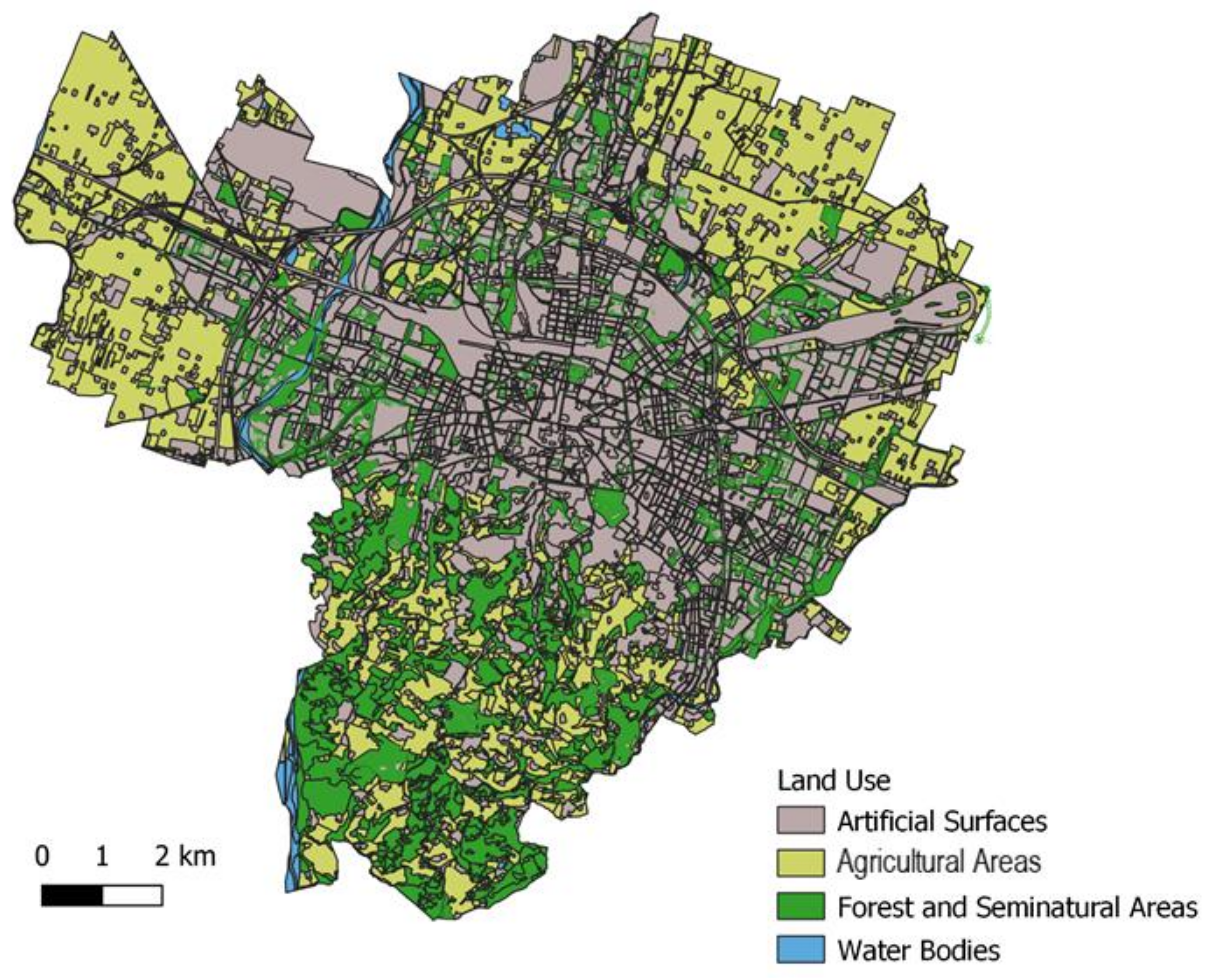
2.1. Case Study Area: The City of Bologna
2.2. Distribution and Proximity Analysis of UGSs
- −
- UGS distribution;
- −
- Access points to the UGS as the intersections of the park roads and main road points;
- −
- Road network (one layer including all road networks that crosses the city, including cycle lane, hiking, and pedestrian paths).
2.3. UGS Availability Analysis in the Park
3. Results
3.1. Proximity Analysis
3.2. Availability Analysis
4. Discussion and Conclusions
Author Contributions
Funding
Institutional Review Board Statement
Informed Consent Statement
Data Availability Statement
Conflicts of Interest
References
- Xie, J.; Luo, S.; Furuya, K.; Sun, D. Urban Parks as Green Buffers During the COVID-19 Pandemic. Sustainability 2020, 12, 6751. [Google Scholar] [CrossRef]
- Venter, Z.S.; Barton, D.N.; Gundersen, V.; Figari, H.; Nowell, M. Urban Nature in a Time of Crisis: Recreational Use of Green Space Increases during the COVID-19 Outbreak in Oslo, Norway. Environ. Res. Lett. 2020, 15. [Google Scholar] [CrossRef]
- Ugolini, F.; Massetti, L.; Calaza-Martínez, P.; Cariñanos, P.; Dobbs, C.; Ostoic, S.K.; Marin, A.M.; Pearlmutter, D.; Saaroni, H.; Šaulienė, I.; et al. Effects of the COVID-19 Pandemic on the Use and Perceptions of Urban Green Space: An International Exploratory Study. Urban For. Urban Green. 2020, 56. [Google Scholar] [CrossRef] [PubMed]
- Lee, A.C.K.; Jordan, H.C.; Horsley, J. Value of Urban Green Spaces in Promoting Healthy Living and Wellbeing: Prospects for Planning. Risk Manag. Healthcare Policy 2015, 8, 131. [Google Scholar] [CrossRef] [PubMed] [Green Version]
- Van Den Bosch, M.; Ode Sang, Å. Urban Natural Environments as Nature-Based Solutions for Improved Public Health-A Systematic Review of Reviews. Environ. Res. 2017, 158, 373–384. [Google Scholar] [CrossRef]
- Barton, J.; Pretty, J. What Is the Best Dose of Nature and Green Exercise for Improving Mental Health-A Multi-Study Analysis. Environ. Sci. Technol. 2010, 44, 3947–3955. [Google Scholar] [CrossRef]
- Bush, C.L.; Pittman, S.; McKay, S.; Ortiz, T.; Wong, W.W.; Klish, W.J. Park-Based Obesity Intervention Program for Inner-City Minority Children. J. Pediatr. 2007, 151, 513–518. [Google Scholar] [CrossRef] [PubMed]
- Maas, J.; Verheij, R.A.; De Vries, S.; Spreeuwenberg, P.; Schellevis, F.G.; Groenewegen, P.P. Morbidity Is Related to a Green Living Environment. J. Epidemiol. Community Health 2009, 63, 967–973. [Google Scholar] [CrossRef] [Green Version]
- Kabisch, N.; Qureshi, S.; Haase, D. Human-Environment Interactions in Urban Green Spaces-A Systematic Review of Contemporary Issues and Prospects for Future Research. Environ. Impact Assess. Rev. 2015, 50, 25–34. [Google Scholar] [CrossRef]
- Ekkel, E.D.; de Vries, S. Nearby Green Space and Human Health: Evaluating Accessibility Metrics. Landsc. Urban Plan. 2017, 157, 214–220. [Google Scholar] [CrossRef]
- Kabisch, N.; Strohbach, M.; Haase, D.; Kronenberg, J. Urban Green Space Availability in European Cities. Ecol. Indic. 2016, 70, 586–596. [Google Scholar] [CrossRef]
- Li, X.; Zhang, C.; Li, W.; Ricard, R.; Meng, Q.; Zhang, W. Assessing Street-Level Urban Greenery Using Google Street View and a Modified Green View Index. Urban For. Urban Green. 2015, 14. [Google Scholar] [CrossRef]
- Massoni, E.S.; Barton, D.N.; Rusch, G.M.; Gundersen, V. Bigger, More Diverse and Better? Mapping Structural Diversity and Its Recreational Value in Urban Green Spaces. Ecosyst. Serv. 2018, 31. [Google Scholar] [CrossRef]
- Astell-Burt, T.; Navakatikyan, M.A.; Feng, X. Urban Green Space, Tree Canopy and 11-Year Risk of Dementia in a Cohort of 109,688 Australians. Environ. Int. 2020, 145, 106102. [Google Scholar] [CrossRef] [PubMed]
- De Keijzer, C.; Gascon, M.; Nieuwenhuijsen, M.J.; Dadvand, P. Long-Term Green Space Exposure and Cognition across the Life Course: A Systematic Review. Curr. Environ. Heal. Rep. 2016, 3, 468–477. [Google Scholar] [CrossRef]
- Andersson, E.; Tengö, M.; McPhearson, T.; Kremer, P. Cultural Ecosystem Services as a Gateway for Improving Urban Sustainability. Ecosyst. Serv. 2015, 12, 165–168. [Google Scholar] [CrossRef]
- Forrest, R.; Kearns, A. Social Cohesion, Social Capital and the Neighbourhood. Urban Stud. 2001, 38, 2125–2143. [Google Scholar] [CrossRef]
- Sugiyama, T.; Leslie, E.; Giles-Corti, B.; Owen, N. Associations of Neighbourhood Greenness with Physical and Mental Health: Do Walking, Social Coherence and Local Social Interaction Explain the Relationships? J. Epidemiol. Community Health 2008, 62. [Google Scholar] [CrossRef] [PubMed] [Green Version]
- De Vries, S.; van Dillen, S.M.E.; Groenewegen, P.P.; Spreeuwenberg, P. Streetscape Greenery and Health: Stress, Social Cohesion and Physical Activity as Mediators. Soc. Sci. Med. 2013, 94, 26–33. [Google Scholar] [CrossRef] [PubMed] [Green Version]
- Potschin, M.B.; Haines-Young, R.H. Ecosystem Services: Exploring a Geographical Perspective. Prog. Phys. Geogr. 2011, 35, 575–594. [Google Scholar] [CrossRef]
- Potschin-Young, M.; Haines-Young, R.; Görg, C.; Heink, U.; Jax, K.; Schleyer, C. Understanding the Role of Conceptual Frameworks: Reading the Ecosystem Service Cascade. Ecosyst. Serv. 2018, 29, 428–440. [Google Scholar] [CrossRef]
- Shi, L.; Halik, Ü.; Abliz, A.; Mamat, Z.; Welp, M. Urban Green Space Accessibility and Distribution Equity in an Arid Oasis City: Urumqi, China. Forests 2020, 11. [Google Scholar] [CrossRef]
- Jennings, V.; Larson, L.; Yun, J. Advancing Sustainability through Urban Green Space: Cultural Ecosystem Services, Equity, and Social Determinants of Health. Int. J. Environ. Res. Public Health 2016, 13. [Google Scholar] [CrossRef] [PubMed] [Green Version]
- Wen, C.; Albert, C.; Von Haaren, C. Equality in Access to Urban Green Spaces: A Case Study in Hannover, Germany, with a Focus on the Elderly Population. Urban For. Urban Green. 2020, 55, 126820. [Google Scholar] [CrossRef]
- De Luca, C.; Langemeyer, J.; Vaňo, S.; Baró, F.; Andersson, E. Adaptive Resilience of and through Urban Ecosystem Services: A Transdisciplinary Approach to Sustainability in Barcelona. Ecol. Soc. in press. 2021. [Google Scholar]
- Artmann, M.; Mueller, C.; Goetzlich, L.; Hof, A. Supply and Demand Concerning Urban Green Spaces for Recreation by Elderlies Living in Care Facilities: The Role of Accessibility in an Explorative Case Study in Austria. Front. Environ. Sci. 2019, 7, 1–12. [Google Scholar] [CrossRef]
- City of Vienna. STEP 2025-Urban Development Plan Vienna; City of VIenna: Vienna, Austria, 2014; Volume 148, pp. 148–162. [Google Scholar]
- Ministerial Decree, n.97 April 1968.pdf. Available online: https://www.gazzettaufficiale.it/eli/id/1968/04/16/1288Q004/sg (accessed on 4 October 2021).
- Le Texier, M.; Schiel, K.; Caruso, G. The Provision of Urban Green Space and Its Accessibility: Spatial Data Effects in Brussels. PLoS ONE 2018, 13, 1–17. [Google Scholar] [CrossRef]
- Milcu, A.I.; Hanspach, J.; Abson, D.; Fischer, J. Cultural Ecosystem Services: A Literature Review and Prospects for Future Research. Ecol. Soc. 2013, 18. [Google Scholar] [CrossRef] [Green Version]
- Baycan-Levent, T.; Nijkamp, P. Planning and Management of Urban Green Spaces in Europe: Comparative Analysis. J. Urban Plan. Dev. 2009, 135, 1–12. [Google Scholar] [CrossRef]
- Van Herzele, A.; Wiedemann, T. A Monitoring Tool for the Provision of Accessible and Attractive Urban Green Spaces. Landsc. Urban Plan. 2003, 63, 109–126. [Google Scholar] [CrossRef]
- Martins, B.; Nazaré Pereira, A. Index for Evaluation of Public Parks and Gardens Proximity Based on the Mobility Network: A Case Study of Braga, Braganza and Viana Do Castelo (PortUGSl) and Lugo and Pontevedra (Spain). Urban For. Urban Green. 2018, 34, 134–140. [Google Scholar] [CrossRef]
- Quatrini, V.; Tomao, A.; Corona, P.; Ferrari, B.; Masini, E.; Agrimi, M. Is new always better than old? Accessibility and usability of the urban green areas of the municipality of Rome. Urban For. Urban Green. 2019, 37, 126–136. [Google Scholar] [CrossRef]
- Lopez, B.; Kennedy, C.; McPhearson, T. Parks are Critical Urban Infrastructure: Perception and Use of Urban Green Spaces in NYC During COVID-19. Preprints 2020, 1–22. [Google Scholar] [CrossRef]
- Larcher, F.; Pomatto, E.; Battisti, L.; Gullino, P.; Devecchi, M. Perceptions of Urban Green Areas during the Social Distancing Period for COVID-19 Containment in Italy. Horticulturae 2021, 7. [Google Scholar] [CrossRef]
- Shoari, N.; Ezzati, M.; Baumgartner, J.; Malacarne, D.; Fecht, D. Accessibility and Allocation of Public Parks and Gardens in England and Wales: A COVID-19 Social Distancing Perspective. PLoS ONE 2020, 15, 1–10. [Google Scholar] [CrossRef]
- Andersson, E.; Langemeyer, J.; Borgström, S.; McPhearson, T.; Haase, D.; Kronenberg, J.; Barton, D.N.; Davis, M.; Naumann, S.; Röschel, L.; et al. Enabling Green and Blue Infrastructure to Improve Contributions to Human Well-Being and Equity in Urban Systems. Bioscience 2019, 69, 566–574. [Google Scholar] [CrossRef]
- Camps-Calvet, M.; Langemeyer, J.; Calvet-Mir, L.; Gómez-Baggethun, E. Ecosystem Services Provided by Urban Gardens in Barcelona, Spain: Insights for Policy and Planning. Environ. Sci. Policy 2016, 62, 14–23. [Google Scholar] [CrossRef]
- Hamstead, Z.A.; Fisher, D.; Ilieva, R.T.; Wood, S.A.; McPhearson, T.; Kremer, P. Geolocated Social Media as a Rapid Indicator of Park Visitation and Equitable Park Access. Comput. Environ. Urban Syst. 2018, 72, 38–50. [Google Scholar] [CrossRef]
- Ye, C.; Hu, L.; Li, M. Urban Green Space Accessibility Changes in a High-Density City: A Case Study of Macau From 2010 to 2015. J. Transp. Geogr. 2018, 66, 106–115. [Google Scholar] [CrossRef]
- Hegetschweiler, K.T.; de Vries, S.; Arnberger, A.; Bell, S.; Brennan, M.; Siter, N.; Olafsson, A.S.; Voigt, A.; Hunziker, M. Linking Demand and Supply Factors in Identifying Cultural Ecosystem Services of Urban Green Infrastructures: A Review of European Studies. Urban For. Urban Green. 2017, 21, 48–59. [Google Scholar] [CrossRef] [Green Version]
- European Commission. Mapping Guide v6.1 European for a European Urban Atlas; European Commission: Brussels, Belgium, 2020; pp. 1–228. [Google Scholar]
- Comber, A.; Brunsdon, C.; Green, E. Using a GIS-Based Network Analysis to Determine Urban Greenspace Accessibility for Different Ethnic and Religious Groups. Landsc. Urban Plan. 2008, 86, 103–114. [Google Scholar] [CrossRef] [Green Version]
- La Rosa, D. Accessibility to Greenspaces: GIS Based Indicators for Sustainable Planning in a Dense Urban Context. Ecol. Indic. 2014, 42, 122–134. [Google Scholar] [CrossRef]
- Grunewald, K.; Richter, B.; Meinel, G.; Herold, H.; Syrbe, R.U. Proposal of Indicators Regarding the Provision and Accessibility of Green Spaces for Assessing the Ecosystem Service “Recreation in the City” in Germany. Int. J. Biodivers. Sci. Ecosyst. Serv. Manag. 2017, 13, 26–39. [Google Scholar] [CrossRef] [Green Version]
- Maes, J.; Liquete, C.; Teller, A.; Erhard, M.; Paracchini, M.L.; Barredo, J.I.; Grizzetti, B.; Cardoso, A.; Somma, F.; Petersen, J.-E.; et al. An Indicator Framework for Assessing Ecosystem Services in Support of the EU Biodiversity Strategy to 2020. Ecosyst. Serv. 2016, 17, 14–23. [Google Scholar] [CrossRef] [Green Version]
- Sister, C.E.; Wilson, J.P.; Wolch, J. Park Congestion and Strategies to Increase Park Equity. 2007. Available online: http://www.ced.berkeley.edu/downloads/pubs/faculty/wolch_2007_park-congestion-strategies-park-equity.pdf. (accessed on 4 October 2021).
- Gupta, K.; Roy, A.; Luthra, K.; Maithani, S. Mahavir GIS Based Analysis for Assessing the Accessibility at Hierarchical Levels of Urban Green Spaces. Urban For. Urban Green. 2016, 18, 198–211. [Google Scholar] [CrossRef]
- Syrbe, R.U.; Grunewald, K. Ecosystem Service Supply and Demand–The Challenge to Balance Spatial Mismatches. Int. J. Biodivers. Sci. Ecosyst. Serv. Manag. 2017, 13, 148–161. [Google Scholar] [CrossRef] [Green Version]
- Vignoli, F.; de Luca, C.; Tondelli, S. A Spatial Ecosystem Services Assessment to Support Decision and Policy Making: The Case of the City of Bologna. Sustainabilty 2021, 13, 1–19. [Google Scholar] [CrossRef]
- Tian, Y.; Jim, C.Y.; Wang, H. Assessing the Landscape and Ecological Quality of Urban Green Spaces in a Compact City. Landsc. Urban Plan. 2014, 121, 97–108. [Google Scholar] [CrossRef]
- Aquino, F.L.; Gainza, X. Understanding Density in an Uneven City, Santiago de Chile: Implications for Social and Environmental Sustainability. Sustainability 2014, 6, 5876–5897. [Google Scholar] [CrossRef] [Green Version]
- Pouso, S.; Borja, Á.; Fleming, L.E.; Gómez-Baggethun, E.; White, M.P.; Uyarra, M.C. Contact with Blue-Green Spaces during the COVID-19 Pandemic Lockdown Beneficial for Mental Health. Sci. Total Environ. 2020, 756, 143984. [Google Scholar] [CrossRef]
- Ameh, G.G.; Njoku, A.; Inungu, J.; Younis, M. Rural America and Coronavirus Epidemic: Challenges and Solutions. Eur. J. Environ. Public Health 2020, 4, 2–5. [Google Scholar]
- Broitman, D.; Koomen, E. The Attraction of Urban Cores: Densification in Dutch City Centres. Urban Stud. 2020, 57, 1920–1939. [Google Scholar] [CrossRef]
- Maes, J.; Zulian, G.; Günther, S.; Martijn, T.; Raynal, J. Enhancing Resilience of Urban Ecosyxstems throug Green Infrastructure (EnRoute); Publications Office of the European Union: Luxembourg, 2019; pp. 1–115. [Google Scholar]


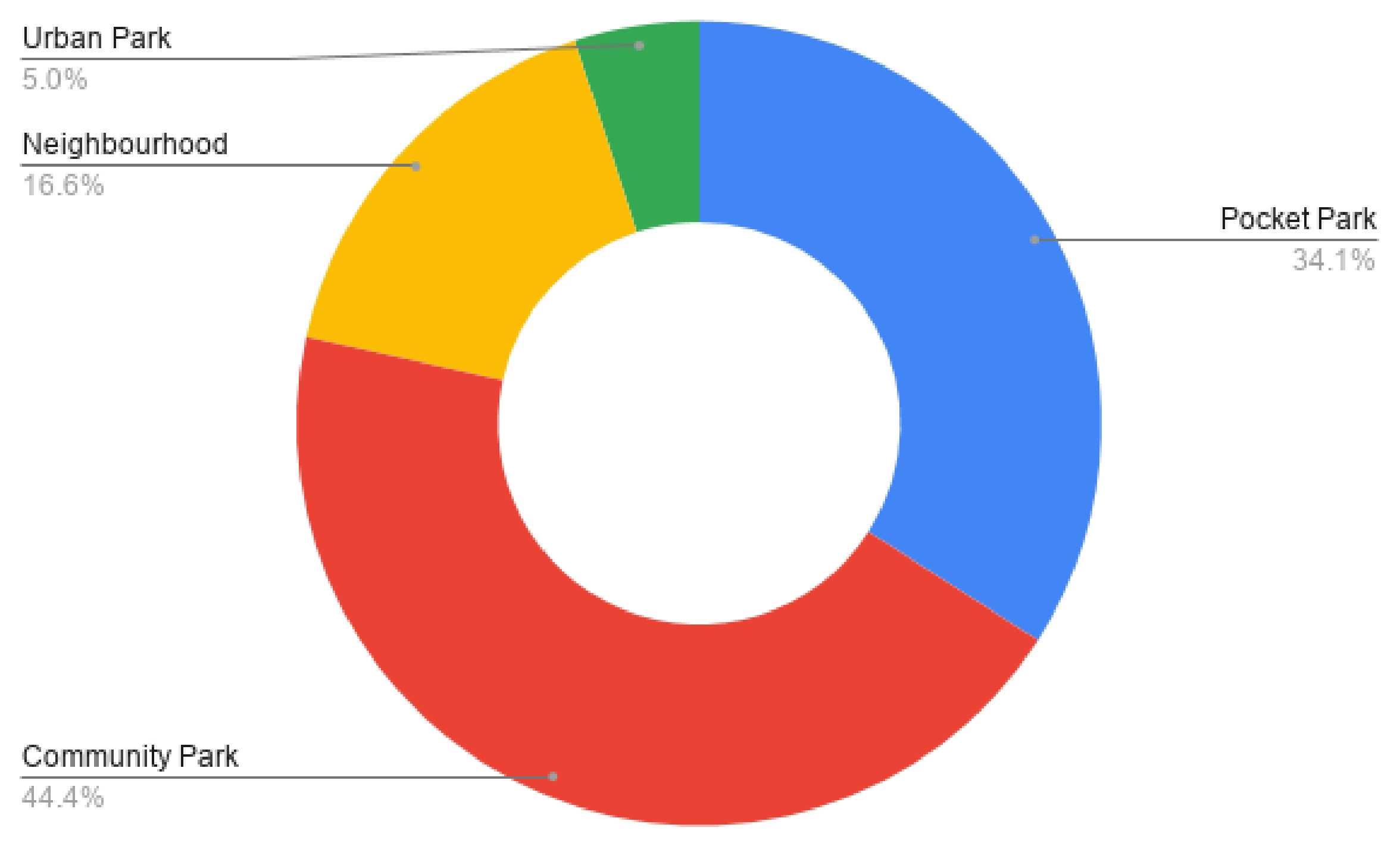
| UGS Class | UGS Area | Network Distance |
|---|---|---|
| Pocket park | 0–0.5 Ha | 200 m |
| Community park | 0.5–2.5 Ha | 300 m |
| Neighborhood park | 2.5–10 Ha | 500 m |
| Urban park | >10 Ha | 1000 m |
| Per Capita Sqm | UGS Pressure |
|---|---|
| >17 | Low |
| 9–17 | Medium |
| <9 | High |
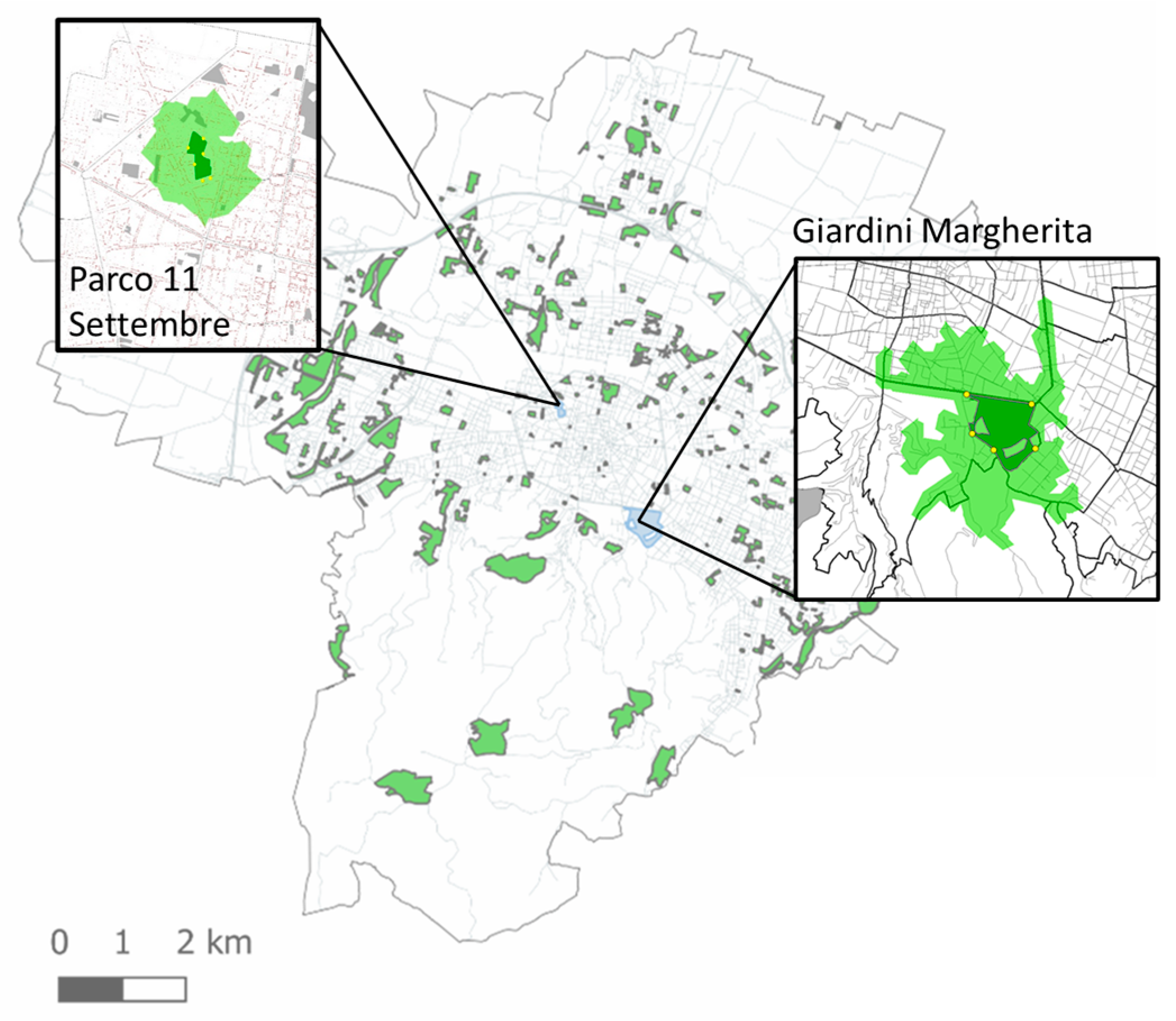
| Served Population | Network Distance and Type If UGS | Pressure over the UGS |
|---|---|---|
| 6682 | Community Park—300 m | 3.4 sqm/capita—high |
| 12262 | Urban Park—1000 m | 17.6 sqm/capita—low |
Publisher’s Note: MDPI stays neutral with regard to jurisdictional claims in published maps and institutional affiliations. |
© 2021 by the authors. Licensee MDPI, Basel, Switzerland. This article is an open access article distributed under the terms and conditions of the Creative Commons Attribution (CC BY) license (https://creativecommons.org/licenses/by/4.0/).
Share and Cite
De Luca, C.; Libetta, A.; Conticelli, E.; Tondelli, S. Accessibility to and Availability of Urban Green Spaces (UGS) to Support Health and Wellbeing during the COVID-19 Pandemic—The Case of Bologna. Sustainability 2021, 13, 11054. https://doi.org/10.3390/su131911054
De Luca C, Libetta A, Conticelli E, Tondelli S. Accessibility to and Availability of Urban Green Spaces (UGS) to Support Health and Wellbeing during the COVID-19 Pandemic—The Case of Bologna. Sustainability. 2021; 13(19):11054. https://doi.org/10.3390/su131911054
Chicago/Turabian StyleDe Luca, Claudia, Andrea Libetta, Elisa Conticelli, and Simona Tondelli. 2021. "Accessibility to and Availability of Urban Green Spaces (UGS) to Support Health and Wellbeing during the COVID-19 Pandemic—The Case of Bologna" Sustainability 13, no. 19: 11054. https://doi.org/10.3390/su131911054