(In)Equitable Accessibility to Sustainable Transport from Universities in the Guadalajara Metropolitan Area, Mexico


Abstract
:1. Introduction
2. Materials and Methods
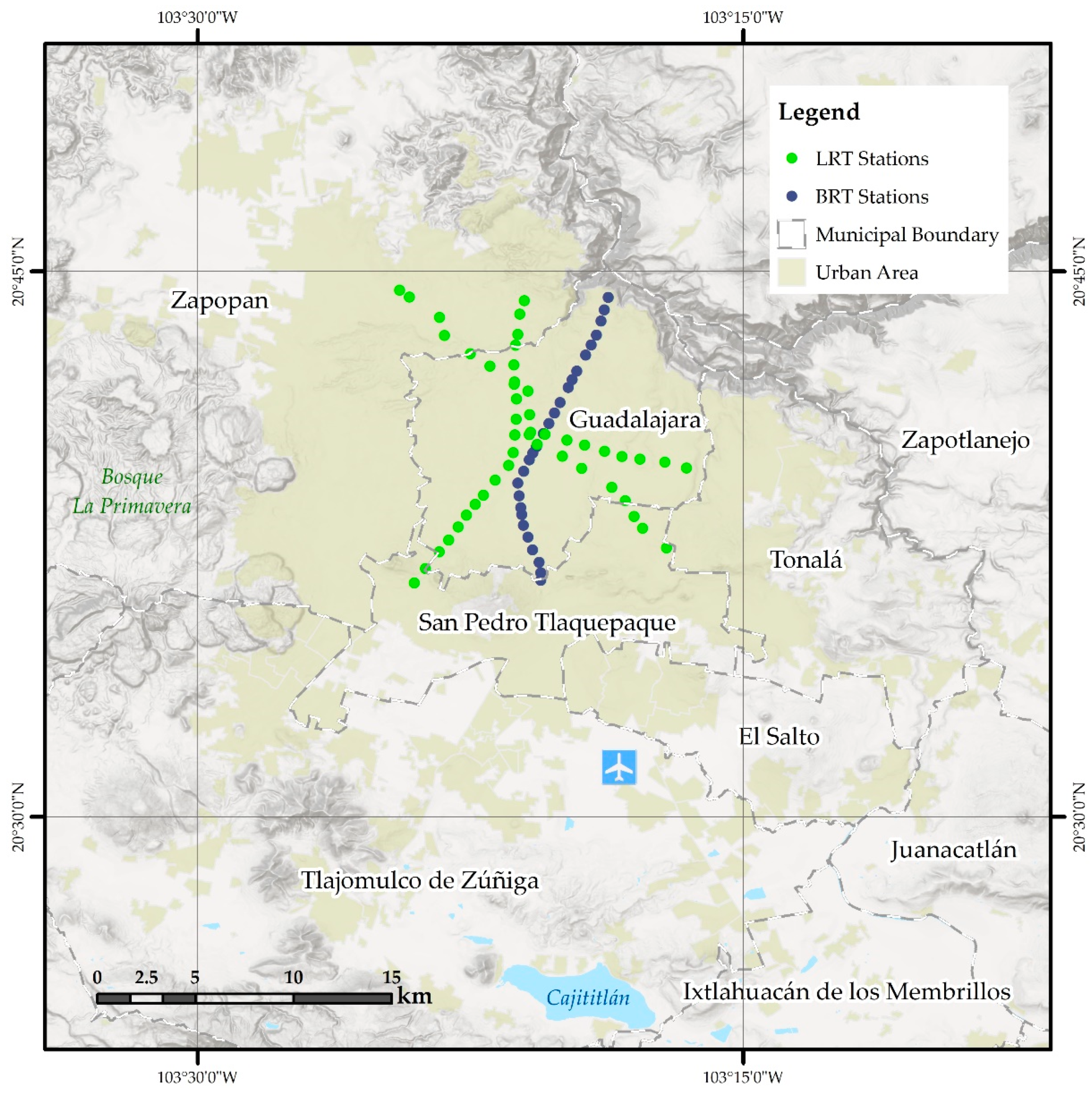
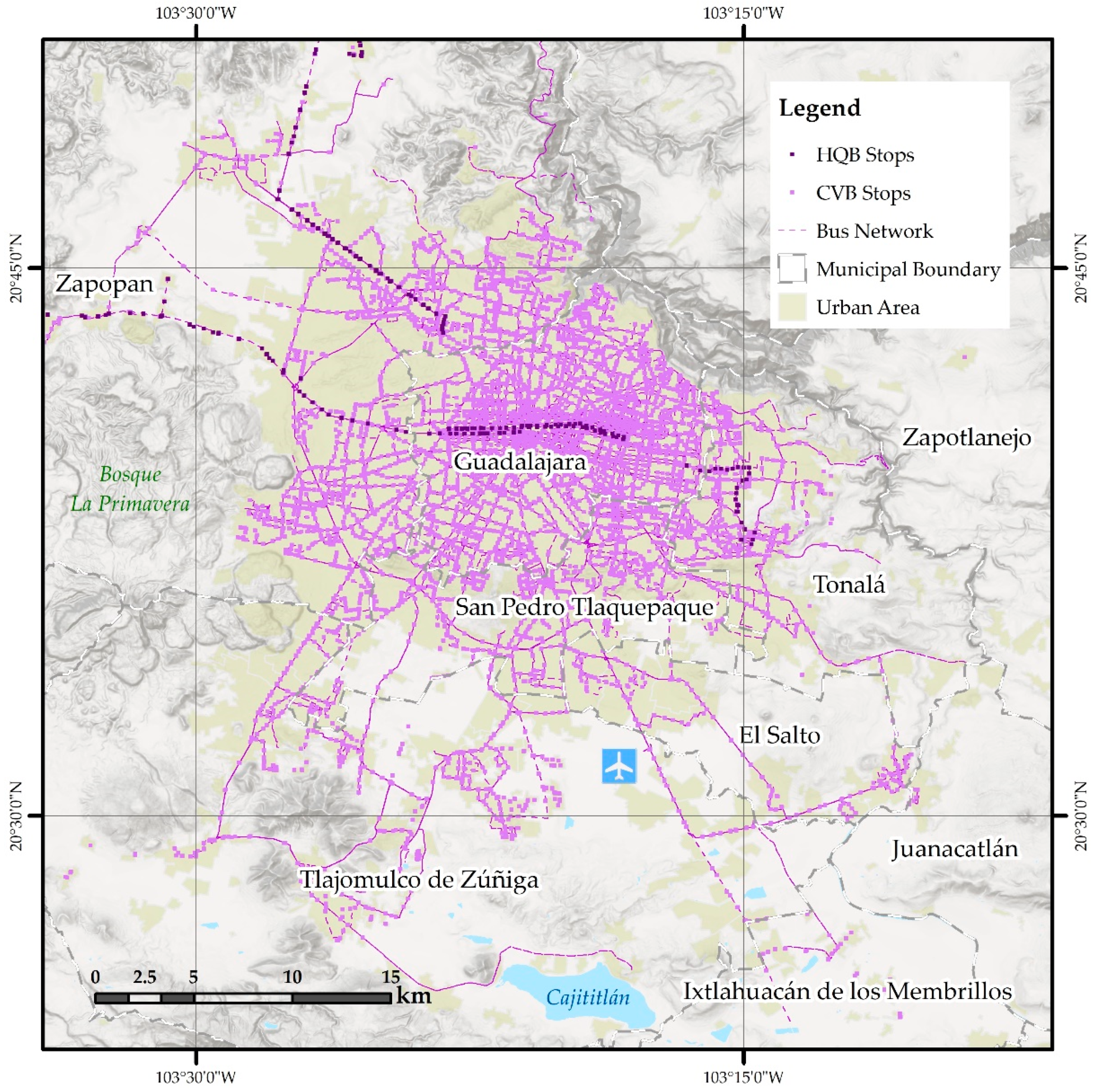
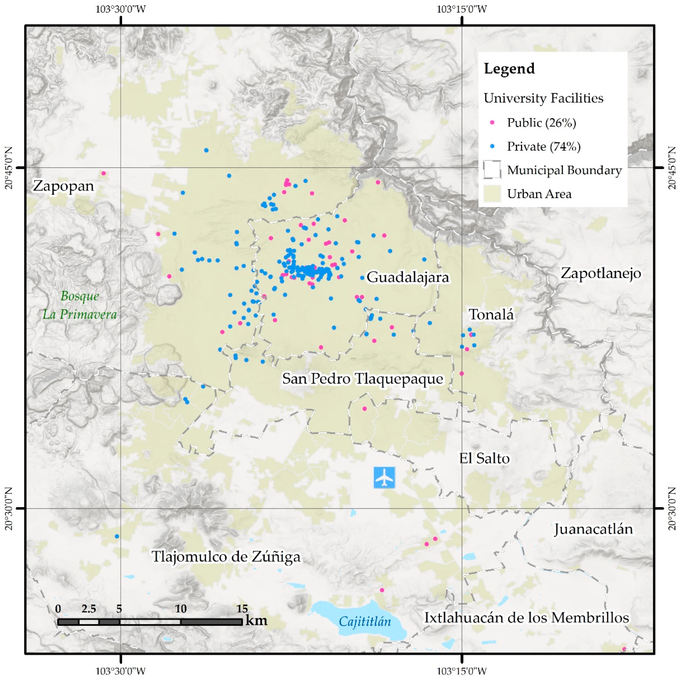
2.1. Study Area
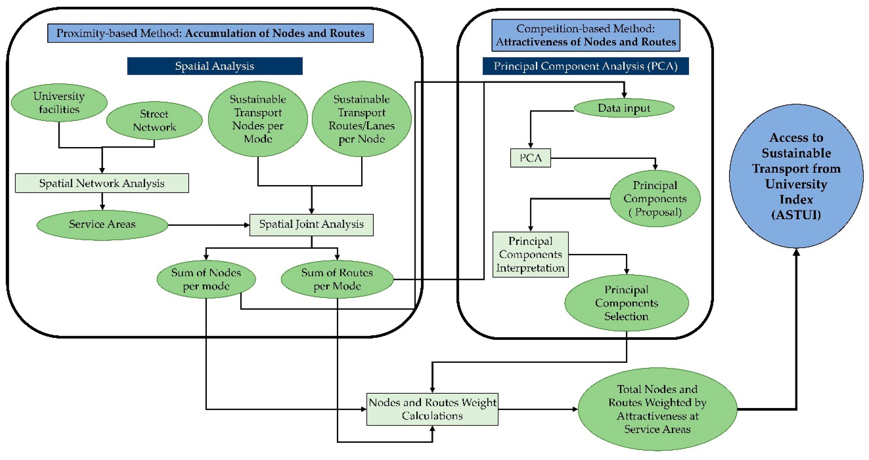
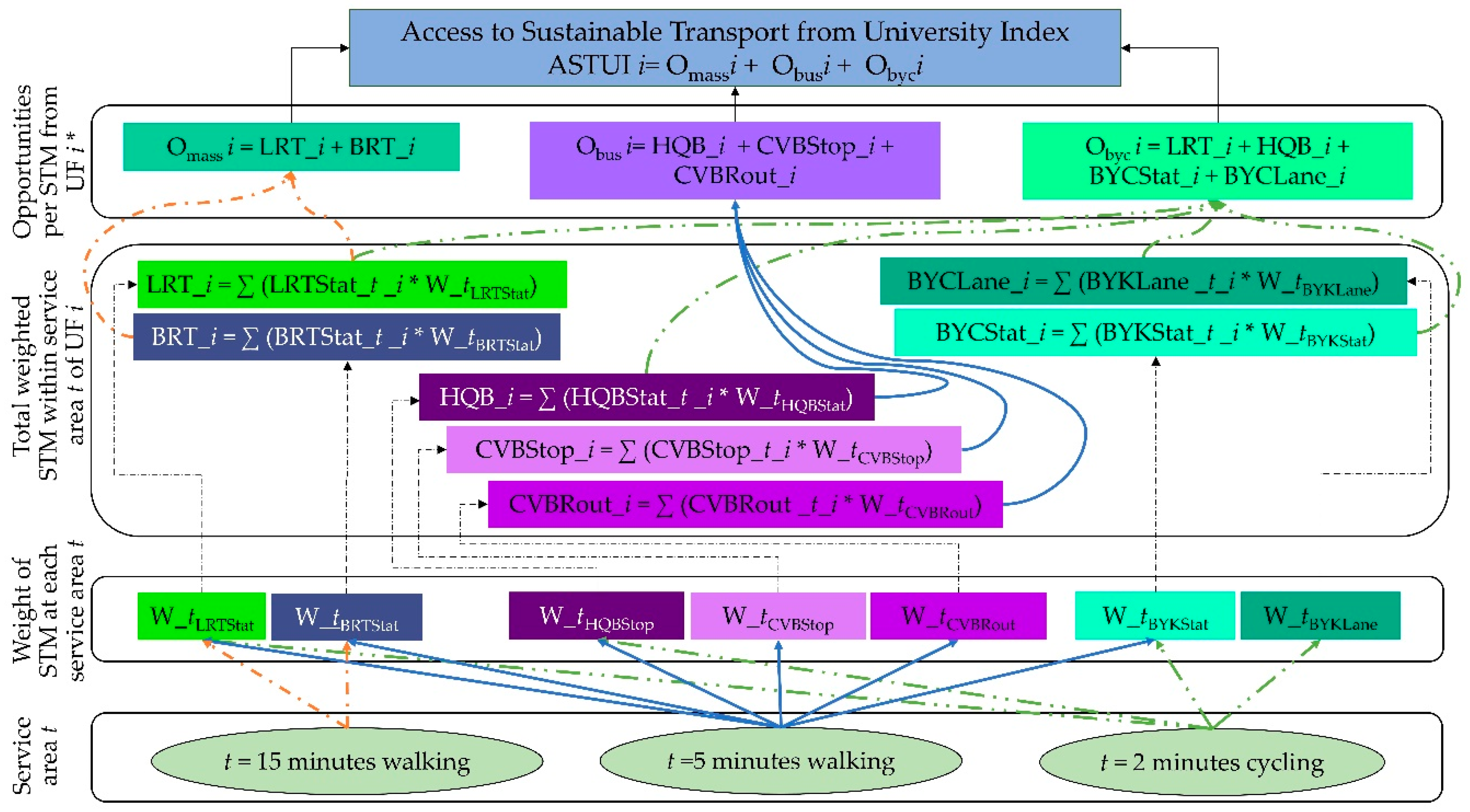
2.2. Methodology
F15_BRTStat + 0.047106 * F5_BRTStat + 0.255624 * F5_HQBStop + 0.283082 * B2_HQBStop + 0.352379 *
F5_CVBStop + 0.329129 * F5_CVBRout + 0.361178 * F5_ BYKStat + 0.378923 * B2_BYKStat + 0.3027 *
B2_BYKLane
WIn + J * WJ n+ K * WKn + L * WLn
Component_3)]/[Eigenvalue_1 + Eigenvalue_2 + Eigenvalue_3]
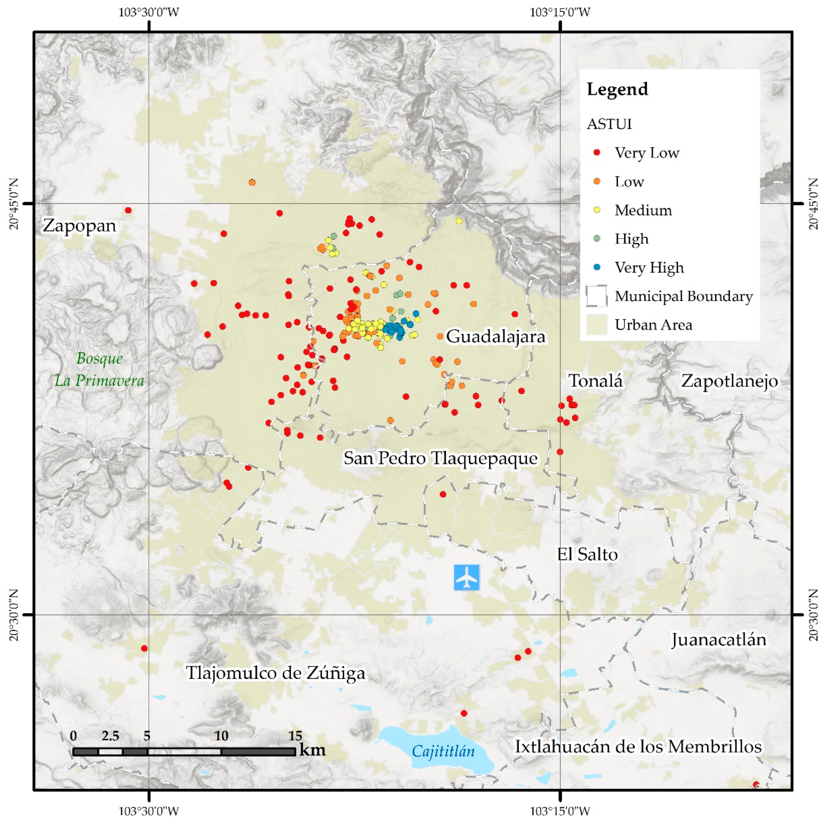
3. Results and Discussion
4. Conclusions
- Considering the topography and urban environment as elements of effective mobility for the measurement of hindrances affecting the walking time to the stops/stations.
- Computing a sensitivity analysis for different service areas.
- Including the BRT line currently under construction. According to Jalisco [112], this line will serve more than 49,000 students.
- Considering income, gender, physical ability, or other vulnerabilities in the student population.
- Accounting for the impact of transport fees in the model.
- Including data from smartcards and General Transit Feed Specifications as soon as they are available.
- Transferring the proposed methodology to the calculation of indices for other basic goods, such as health, cultural, or basic educational infrastructure.
Author Contributions
Funding
Institutional Review Board Statement
Informed Consent Statement
Data Availability Statement
Acknowledgments
Conflicts of Interest
References
- Astakhova, K.V.; Korobeev, A.I.; Prokhorova, V.V.; Kolupaev, A.A.; Vorotnoy, M.V.; Kucheryavaya, E.R. The Role of Education in Economic and Social Development of the Country. Int. Rev. Manag. Mark. 2016, 6, 53–58. [Google Scholar]
- Kelobonye, K.; McCarney, G.; Xia, J.; Swapan, M.S.H.; Mao, F.; Zhou, H. Relative Accessibility Analysis for Key Land Uses: A Spatial Equity Perspective. J. Transp. Geogr. 2019, 75, 82–93. [Google Scholar] [CrossRef]
- Xia, J.; Nesbitt, J.; Daley, R.; Najnin, A.; Litman, T.; Tiwari, S.P. A Multi-Dimensional View of Transport-Related Social Exclusion: A Comparative Study of Greater Perth and Sydney. Transp. Res. Part A Policy Pract. 2016, 94, 205–221. [Google Scholar] [CrossRef] [Green Version]
- Guthrie, A.; Fan, Y.; Van Dort, L.; Baas, G. Advancing Transportation Equity: Research and Practice; Minnesota Department of Transportation: Saint Paul, MN, USA, 2019; p. 81. [Google Scholar]
- Litman, T. Evaluating Transportation Equity. World Transp. Policy Pract. 2002, 8, 50–65. [Google Scholar]
- Wachs, M.; Kumagai, T.G. Physical Accessibility as a Social Indicator. Socio-Econ. Plan. Sci. 1973, 7, 437–456. [Google Scholar] [CrossRef]
- Kenyon, S. Tackling Transport-Related Social Exclusion: Considering Virtual Access to Opportunities, Services and Social Networks. New Technol. Hum. Serv. 2002, 14, 10–22. [Google Scholar]
- Kenyon, S.; Lyons, G.; Rafferty, J. Transport and Social Exclusion: Investigating the Possibility of Promoting Inclusion through Virtual Mobility. J. Transp. Geogr. 2002, 10, 207–219. [Google Scholar] [CrossRef] [Green Version]
- Litman, T. Evaluating Accessibility for Transportation Planning. Measuring People’s Ability To Reach Desired Goods and Activities. Vic. Transp. Policy Inst. 2012, 50. Available online: http://www.vtpi.org (accessed on 3 November 2020).
- Lucas, K. A New Evolution for Transport-Related Social Exclusion Research? J. Transp. Geogr. 2019, 81, 102529. [Google Scholar] [CrossRef]
- Social Exclusion Unit. Making the Connections: Final Report on Transport and Social Exclusion; Office of the Deputy Prime Minister: London, UK, 2003; p. 147.
- Bertolini, L.; le Clercq, F.; Kapoen, L. Sustainable Accessibility: A Conceptual Framework to Integrate Transport and Land Use Plan-Making. Two Test-Applications in the Netherlands and a Reflection on the Way Forward. Transp. Policy 2005, 12, 207–220. [Google Scholar] [CrossRef]
- Cervero, R. Paradigm Shift: From Automobility to Accessibility Planning. Urban Futures (Canberra) 1997, 22, 9–20. [Google Scholar]
- Guthrie, A. Can Transit-Oriented Development Enhance Social Equity: Current State and Active Promotion of Equitable Transit-Oriented Development; University of Minnesota: Minneapolis, MN, USA, 2018. [Google Scholar]
- Handy, S. Is Accessibility an Idea Whose Time Has Finally Come? Transp. Res. Part D Transp. Environ. 2020, 83, 102319. [Google Scholar] [CrossRef]
- Kamruzzaman, M.; Yigitcanlar, T.; Yang, J.; Mohamed, M.A. Measures of Transport-Related Social Exclusion: A Critical Review of the Literature. Sustainability 2016, 8, 696. [Google Scholar] [CrossRef] [Green Version]
- Schwanen, T.; Lucas, K.; Akyelken, N.; Cisternas Solsona, D.; Carrasco, J.-A.; Neutens, T. Rethinking the Links between Social Exclusion and Transport Disadvantage through the Lens of Social Capital. Transp. Res. Part A Policy Pract. 2015, 74, 123–135. [Google Scholar] [CrossRef]
- Talavera-Garcia, R.; Valenzuela-Montes, L.M. Conceptual Analysis of Walking Distance to Transit: Towards a More Integrative Approach. Ace-Arch. City Environ. 2018, 13, 183–204. [Google Scholar] [CrossRef]
- Cheng, J.; Yan, R.; Gao, Y. Exploring Spatial Heterogeneity in Accessibility and Transit Mode Choice. Transp. Res. Part D Transp. Environ. 2020, 87, 102521. [Google Scholar] [CrossRef]
- Ermagun, A.; Tilahun, N. Equity of Transit Accessibility across Chicago. Transp. Res. Part D Transp. Environ. 2020, 86, 102461. [Google Scholar] [CrossRef]
- Gutiérrez-Puebla, J.; García-Palomares, J.C.; Alventosa, C.; Redondo, J.C.; Paniagua, E. Accesibilidad peatonal a la red sanitaria de asistencia primaria en Madrid. An. De Geogr. De La Univ. Complut. 2002, 1, 269–280. [Google Scholar]
- Guzman, L.A.; Oviedo, D.; Rivera, C. Assessing Equity in Transport Accessibility to Work and Study: The Bogotá Region. J. Transp. Geogr. 2017, 58, 236–246. [Google Scholar] [CrossRef]
- Lamíquiz Daudén, F.J. Implicaciones de la Accesibilidad Configuracional en la Movilidad Peatonal. El caso de Madrid. Ph.D. Thesis, Universidad Politécnica de Madrid, Madrid, Spain, 2011. Available online: http://oa.upm.es/15031/ (accessed on 10 October 2020).
- Pritchard, J.P.; Tomasiello, D.B.; Giannotti, M.; Geurs, K. Potential Impacts of Bike-and-Ride on Job Accessibility and Spatial Equity in São Paulo, Brazil. Transp. Res. Part A Policy Pract. 2019, 121, 386–400. [Google Scholar] [CrossRef]
- Stępniak, M.; Pritchard, J.P.; Geurs, K.T.; Goliszek, S. The Impact of Temporal Resolution on Public Transport Accessibility Measurement: Review and Case Study in Poland. J. Transp. Geogr. 2019, 75, 8–24. [Google Scholar] [CrossRef]
- Bocarejo S, J.P.; Oviedo H, D.R. Transport Accessibility and Social Inequities: A Tool for Identification of Mobility Needs and Evaluation of Transport Investments. J. Transp. Geogr. 2012, 24, 142–154. [Google Scholar] [CrossRef]
- Calonge Reillo, F.; Aceves Arce, R.H. Viajando por sectores no centrales del área metropolitana de Guadalajara, México. La escasez de recursos y de alternativas de transporte como condicionantes de la exclusión social. Sociológica 2019, 34, 137–168. [Google Scholar] [CrossRef]
- Esquivel-Cuevas, M.; Hernández-Mercado, O.A.; Garnica-Monroy, R. Pedestrian Accessibility Model. Pedestrian accessibility index at neighborhood scale. Bitácora Urbano Territ. 2013, 23, 21–30. [Google Scholar]
- Grindlay, A.L.; Jaramillo, C.; Lizárraga, C. Spatial Relationships Between Mobility Opportunities and Constraints of Transport Disadvantages: The Case of Santiago De Cali, Colombia. In Urban Transport Xxiii; Ricci, S., Brebbia, C.A., Eds.; Wit Press: Southampton, UK, 2018; Volume 176, pp. 119–129. ISBN 978-1-78466-210-3. [Google Scholar]
- Guzman, L.A.; Oviedo, D. Accessibility, Affordability and Equity: Assessing ‘pro-Poor’ Public Transport Subsidies in Bogotá. Transp. Policy 2018, 68, 37–51. [Google Scholar] [CrossRef]
- Jaramillo, C.; Lizárraga, C.; Grindlay, A.L. Spatial Disparity in Transport Social Needs and Public Transport Provision in Santiago de Cali (Colombia). J. Transp. Geogr. 2012, 24, 340–357. [Google Scholar] [CrossRef]
- Lizárraga, C. Metropolitan expansion and mobility: The case of Caracas. Eure 2012, 38, 99–125. [Google Scholar] [CrossRef] [Green Version]
- Medina, S.; Patlán, M. Modelo de implementación de DOT en la Zona Metropolitana de Guadalajara; Secretaría de Desarrollo Agrario, Territorial y Urbano, Secretaría de Medio Ambiente y Recursos Naturales, ISAID e ITDP: Ciudad de, Mexico, 2016; p. 103. [Google Scholar]
- Pereira, R.H.M. Future Accessibility Impacts of Transport Policy Scenarios: Equity and Sensitivity to Travel Time Thresholds for Bus Rapid Transit Expansion in Rio de Janeiro. J. Transp. Geogr. 2019, 74, 321–332. [Google Scholar] [CrossRef] [Green Version]
- Montoya-Robledo, V.; Escovar-Alvarez, G. Domestic Workers’ Commutes in Bogota: Transportation, Gender and Social Exclusion. Transp. Res. Pt. A-Policy Pract. 2020, 139, 400–411. [Google Scholar] [CrossRef]
- Shirahige, M.; Correa, J. La desigualdad en el acceso al transporte público en el área metropolitana de Santiago: Análisis mediante la aplicación delmodelo PTAL en campamentos y villas de blocks. Rev. Cis 2015, 12, 55–89. [Google Scholar]
- Terán-Hernández, M. Accesibilidad espacial de los servicios de prevención y control del cáncer-cervicouterino en San Luis Potosí | Investigaciones Geográficas. Investig. Geográficas 2017, 94. [Google Scholar] [CrossRef]
- UN-Habitat; Jalisco, G. del E. de J. (Government of the S. of J. Guadalajara-Metropolitana. Prosperidad Urbana: Oportunidades y Propuestas. Guadalajara, 2017. Available online: https://onuhabitat.org.mx/index.php/guadalajara-metropolitana-prosperidad-urbana-oportunidades-y-propuestas (accessed on 26 September 2019).
- Vecchio, G.; Tiznado-Aitken, I.; Hurtubia, R. Transport and Equity in Latin America: A Critical Review of Socially Oriented Accessibility Assessments. Transp. Rev. 2020, 1–28. [Google Scholar] [CrossRef]
- Cohen, T. Tools for Addressing Transport Inequality: A Novel Variant of Accessibility Measurement. J. Transp. Geogr. 2020, 88, 102863. [Google Scholar] [CrossRef]
- Vuchic, V.R. Transportation for Livable Cities; Routledge: Abingdon, UK, 2017; ISBN 978-1-351-31814-3. [Google Scholar]
- UEA, A. de E.U. de B. (Urban E.A., Spain) Guía metodológica para los sistemas de auditoría, certificación o acreditación de la calidad y sostenibilidad en el medio urbano; Centro de publicaciones, Secretaría General Técnica. Ministerio de Fomento, 2012; ISBN 978-84-498-0914-9. Available online: https://www.mitma.gob.es/areas-de-actividad/arquitectura-vivienda-y-suelo/urbanismo-y-politica-de-suelo/urbanismo-y-sostenibilidad-urbana/guia-metodologica-para-los-sistemas-de-auditoria-certificacion-o-acreditacion-de-la-calidad-y-sostenibilidad-en-el-medio-urbano (accessed on 20 December 2020).
- Allen, J.; Farber, S. How Time-Use and Transportation Barriers Limit on-Campus Participation of University Students. Travel Behav. Soc. 2018, 13, 174–182. [Google Scholar] [CrossRef]
- Jalisco, G. del E. de J. (Government of the S. of J. Apoyo al Transporte para Estudiantes. Available online: https://programas.app.jalisco.gob.mx/programas/apoyo/Apoyo-al-transporte-para-estudiantes/663 (accessed on 26 October 2020).
- Cattaneo, M.; Malighetti, P.; Morlotti, C.; Paleari, S. Students’ Mobility Attitudes and Sustainable Transport Mode Choice. IJSHE 2018, 19, 942–962. [Google Scholar] [CrossRef]
- Vecchio, G.; Porreca, R.; Jácome Rivera, D. Socio-Spatial Concerns in Urban Mobility Planning: Insights from Competing Policies in Quito. Sustainability 2020, 12, 2923. [Google Scholar] [CrossRef] [Green Version]
- Oviedo, D.; Guzman, L.A. Revisiting Accessibility in a Context of Sustainable Transport: Capabilities and Inequalities in Bogotá. Sustainability 2020, 12, 4464. [Google Scholar] [CrossRef]
- Macioszek, E.; Kurek, A. The Use of a Park and Ride System—A Case Study Based on the City of Cracow (Poland). Energies 2020, 13, 3473. [Google Scholar] [CrossRef]
- Ibrahim, A.N.H.; Borhan, M.N.; Rahmat, R.A.O.K. Understanding Users’ Intention to Use Park-and-Ride Facilities in Malaysia: The Role of Trust as a Novel Construct in the Theory of Planned Behaviour. Sustainability 2020, 12, 2484. [Google Scholar] [CrossRef] [Green Version]
- Macioszek, E.; Świerk, P.; Kurek, A. The Bike-Sharing System as an Element of Enhancing Sustainable Mobility—A Case Study Based on a City in Poland. Sustainability 2020, 12, 3285. [Google Scholar] [CrossRef] [Green Version]
- Politis, I.; Fyrogenis, I.; Papadopoulos, E.; Nikolaidou, A.; Verani, E. Shifting to Shared Wheels: Factors Affecting Dockless Bike-Sharing Choice for Short and Long Trips. Sustainability 2020, 12, 8205. [Google Scholar] [CrossRef]
- Nikiforiadis, A.; Ayfantopoulou, G.; Stamelou, A. Assessing the Impact of COVID-19 on Bike-Sharing Usage: The Case of Thessaloniki, Greece. Sustainability 2020, 12, 8215. [Google Scholar] [CrossRef]
- IMEPLAN, I.M. de P. (Metropolitan P.I., Guadalajara, Mexico) Criterios para la Prueba Piloto relativa a la Implementacion de los Sistemas de Transporte Individual en Red en sus Diferentes Modalidades para el Área Metropolitana de Guadalajara; Vol. Sistemas de Transporte Individual en Red (STIR). p. 12. Available online: https://www.imeplan.mx/en/home (accessed on 16 December 2020).
- IMEPLAN, I.M. de P. (Metropolitan P.I., Guadalajara, Mexico) Criterios Para La Prueba Piloto Relativos a La Implementación Del Sistema de Bicicletas Sin Anclaje En El Área Metropolitana de Guadalajara. p. 6. Available online: http://imeplan.mx/sites/default/files/archivos_pdf/Criterios-dockless.pdf (accessed on 16 December 2020).
- Hancock, L.; Nuttman, S. Engaging Higher Education Institutions in the Challenge of Sustainability: Sustainable Transport as a Catalyst for Action. J. Clean. Prod. 2014, 62, 62–71. [Google Scholar] [CrossRef]
- Lien, Y.-N.; Wang, J.-D.; Pan, S.-H.; Ho, C.-Y.; Liao, S.-C. Analysis of Bus Commuting Time of High School Students in Taichung City, Taiwan. Adv. Decis. Sci. 2020, 24, 167–189. [Google Scholar]
- Miralles-Guasch, C.; Domene, E. Sustainable Transport Challenges in a Suburban University: The Case of the Autonomous University of Barcelona. Transp. Policy 2010, 17, 454–463. [Google Scholar] [CrossRef]
- Nash, S.; Mitra, R. University Students’ Transportation Patterns, and the Role of Neighbourhood Types and Attitudes. J. Transp. Geogr. 2019, 76, 200–211. [Google Scholar] [CrossRef]
- Pitsiava-Latinopoulou, M.; Basbas, S.; Gavanas, N. Implementation of Alternative Transport Networks in University Campuses: The Case of the Aristotle University of Thessaloniki, Greece. Int. J. Sustain. High. Educ. 2013, 14, 310–323. [Google Scholar] [CrossRef]
- Ricciardi, A.M.; Xia, J.; Currie, G. Exploring Public Transport Equity between Separate Disadvantaged Cohorts: A Case Study in Perth, Australia. J. Transp. Geogr. 2015, 43, 111–122. [Google Scholar] [CrossRef]
- Soltani, A.; Allan, A.; Nguyen, H.A.; Berry, S. Students’ Commuting Pattern from the Viewpoint of Environmentalism: Comparing Australia with China. Int. J. Sustain. High. Educ. 2019, 20, 91–114. [Google Scholar] [CrossRef]
- Stein, M.L.; Grigg, J.A. Missing Bus, Missing School: Establishing the Relationship Between Public Transit Use and Student Absenteeism. Am. Educ. Res. J. 2019, 56, 1834–1860. [Google Scholar] [CrossRef]
- Whannell, P.; Whannell, R.; White, R. Tertiary Student Attitudes to Bicycle Commuting in a Regional Australian University. Int. J. Sustain. High. Educ. 2012, 13, 34–45. [Google Scholar] [CrossRef]
- Cui, B.; Boisjoly, G.; El-Geneidy, A.; Levinson, D. Accessibility and the Journey to Work through the Lens of Equity. J. Transp. Geogr. 2019, 74, 269–277. [Google Scholar] [CrossRef]
- Hine, J.; Mitchell, F. Transport Disadvantage and Social Exclusion: Exclusionary Mechanisms in Transport in Urban Scotland; Transport and Society; Routledge: Aldershot, Hants, UK; Burlington, VT, USA, 2016; ISBN 978-0-7546-1847-8. [Google Scholar]
- Kathuria, A.; Rajendran, B.G.; Parida, M.; Sekhar, C.R. Examining Walk Access to BRT Stations: A Case Study of Ahmedabad BRTs. Inst. Transp. Eng. ITE J. 2019, 89, 43–49. [Google Scholar]
- Özkazanç, S.; Özdemir Sönmez, F.N. Spatial Analysis of Social Exclusion from a Transportation Perspective: A Case Study of Ankara Metropolitan Area. Cities 2017, 67, 74–84. [Google Scholar] [CrossRef]
- Miller, E.J. Accessibility: Measurement and Application in Transportation Planning. Transp. Rev. 2018, 38, 551–555. [Google Scholar] [CrossRef]
- Ansarey, D. Dropouts at the Tertiary Level in Bangladesh: A Case Study in Asa University Bangladesh. J. Sci. Technol. 2016, 6, 93–110. [Google Scholar]
- Centro Mario Molina Proyecto de Movilidad Escolar para el Área Metropolitana de Guadalajara (PROME) Etapa 1; Centro Mario Molina: Guadalajara, Mexico, 2016.
- Franco Cordero, L. La Movilidad Sostenible En Campus Universitarios: Una Comparación de Las Mejores Prácticas En Estados Unidos y Europa. Aplicabilidad En Universidades Venezolanas. Rev. Fac. Ing. UCV 2014, 29, 23–40. [Google Scholar]
- Sun, C.; Cheng, J.; Lin, A.; Peng, M. Gated University Campus and Its Implications for Socio-Spatial Inequality: Evidence from Students’ Accessibility to Local Public Transport. Habitat Int. 2018, 80, 11–27. [Google Scholar] [CrossRef]
- García-Morales, M.J. Movilidad urbana en las Universidades del Área Metropolitana de Guadalajara (AMG), México. Un acercamiento a la sustentabilidad; Estudio de caso, ITESO the Jesuit University of Guadalajara: Tlaquepaque, Mexico, 2020. [Google Scholar]
- Calonge Reillo, F. Gobernanza neoliberal. Retos para el ordenamiento de las movilidades urbanas. Transp. Y Territ. 2017, 16, 184–200. [Google Scholar] [CrossRef]
- UN-Habitat. Estado de las Ciudades de América Latina y el Caribe 2012. Rumbo a una Nueva Transición Urbana; Programa de las Naciones Unidas para los Asentamientos Humanos: Nairobi, Kenya, 2012; Available online: https://unhabitat.org/estado-de-las-ciudades-de-am%C3%A9rica-latina-y-el-caribe-state-of-the-latin-america-and-the-caribbean (accessed on 3 September 2020).
- IMEPLAN, I.M. de P. (Metropolitan P.I., Guadalajara, Mexico) Home|IMEPLAN. Available online: https://www.imeplan.mx/en/home (accessed on 16 December 2020).
- SEDATU, S. de D.A., Territorial y Urbano, México (Ministry of Agrarian, Territorial and Urban Development (Ministry of Agrarian, Territorial and Urban Development), Mexico; GIZ; Ministerio Federal de Medio Ambiente, Protección de la Naturaleza y Seguridad Nuclear de la República Federal de Alemania; Banco Interamericano de Desarrollo. In Anatomia de la Movilidad en México. Hacia Dónde Vamos; SEDATU: Ciudad de, Mexico, 2018; p. 106.
- INEGI, I.N. de E. y G. (National I. of S. and G., Mexico) Conjunto de datos Vectoriales de Información Topográfica F13D55 Tesistán. San Francisco Tesistán Escala 1:50 000 Serie III 2015. Available online: https://www.inegi.org.mx/app/biblioteca/ficha.html?upc=702825270490 (accessed on 30 November 2020).
- INEGI, I.N. de E. y G. (National I. of S. and G., Mexico) Conjunto de datos Vectoriales de Información Topográfica F13D65 Guadalajara Oeste Escala 1:50 000 Serie III 2014. Available online: https://www.inegi.org.mx/app/biblioteca/ficha.html?upc=702825270544 (accessed on 30 November 2020).
- INEGI, I.N. de E. y G. (National I. of S. and G., Mexico) Conjunto de datos Vectoriales de Información Topográfica F13D75 Jocotepec Escala 1:50 000 Serie III 2015. Available online: https://www.inegi.org.mx/app/biblioteca/ficha.html?upc=702825270605 (accessed on 30 November 2020).
- INEGI, I.N. de E. y G. (National I. of S. and G., Mexico) Marco Geoestadístico 2019. Available online: https://www.inegi.org.mx/app/biblioteca/ficha.html?upc=889463776079 (accessed on 30 November 2020).
- SITEUR, S. de T.E.U. (Urban E.T.S., Guadalajara) SITEUR | Sistema de Tren Eléctrico Urbano. Available online: http://www.siteur.gob.mx/noticias.html (accessed on 26 April 2019).
- IMEPLAN, I.M. de P. (Metropolitan P.I., Guadalajara, Mexico) Bus network geometry in the Guadalajara Metropolitan Area 2018. Available online: https://sigmetro.imeplan.mx/login (accessed on 10 September 2020).
- IMEPLAN, I.M. de P. (Metropolitan P.I., Guadalajara, Mexico) SIGmetro. Available online: https://sigmetro.imeplan.mx/mapa (accessed on 26 October 2020).
- Jalisco, G. del E. de J. (Government of the S. of J). In Encuesta de Satisfacción de los Usuarios del Transporte Público en el Área Metropolitana de Guadalajara; Ministry of Transport: Guadalajara, Mexico, 2018; p. 205. Available online: https://www.polymetrix.mx/ (accessed on 7 October 2020).
- INEGI, I.N. de E. y G. (National I. of S. and G., Mexico) National Statistical Directory of Economic Units (DENUE, from Its Initials in Spanish). Available online: https://www.inegi.org.mx/app/descarga/ (accessed on 27 January 2020).
- SEP, S. de E.P. (Public E.S). In Principales Cifras Del Sistema Educativo Nacional 2019-2020; Ministry of Education: Ciudad, Mexico, 2020; p. 134. Available online: http://www.planeacion.sep.gob.mx/ (accessed on 26 October 2020).
- Handy, S.; Niemier, D.A. Measuring Accessibility: An Exploration of Issues and Alternatives-S L Handy, D A Niemeier, 1997. Environ. Plan. A 1997, 29, 1175–1194. [Google Scholar] [CrossRef]
- Al Mamun, M.; Lownes, N. A Composite Index of Public Transit Accessibility. J. Public Transp. 2011, 14. [Google Scholar] [CrossRef]
- Ben-Elia, E.; Benenson, I. A Spatially-Explicit Method for Analyzing the Equity of Transit Commuters’ Accessibility. Transp. Res. Part A: Policy Pract. 2019, 120, 31–42. [Google Scholar] [CrossRef]
- Delbosc, A.; Currie, G. Using Lorenz Curves to Assess Public Transport Equity. J. Transp. Geogr. 2011, 19, 1252–1259. [Google Scholar] [CrossRef]
- Ghorbanzadeh, M.; Kim, K.; Ozguven, E.E.; Horner, M.W. A Comparative Analysis of Transportation-Based Accessibility to Mental Health Services. Transp. Res. Part D Transp. Environ. 2020, 81, 102278. [Google Scholar] [CrossRef]
- Levine, J. A Century of Evolution of the Accessibility Concept. Transp. Res. Part D Transp. Environ. 2020, 83, 102309. [Google Scholar] [CrossRef]
- Martinez, L.M.; Viegas, J.M. Assessing the Impacts of Deploying a Shared Self-Driving Urban Mobility System: An Agent-Based Model Applied to the City of Lisbon, Portugal. Int. J. Transp. Sci. Technol. 2017, 6, 13–27. [Google Scholar] [CrossRef]
- Yenisetty, P.T.; Bahadure, P. Measuring Accessibility to Various ASFs from Public Transit Using Spatial Distance Measures in Indian Cities. ISPRS Int. J. Geo-Inf. 2020, 9, 446. [Google Scholar] [CrossRef]
- CONEVAL, C.N. de E. de la P. de D.S. La Pobreza Urbana en México: Un Enfoque Geoespacial; CONEVAL (Consejo Nacional de Evaluación de la Política de Desarrollo Social), Ciudad de México. 2019, p. 19. Available online: https://www.coneval.org.mx/Medicion/Documents/Pobreza_urbana/Documentos_metodologicos/Nota_tecnica.pdf (accessed on 19 November 2020).
- O’Sullivan, D.; Morrison, A.; Shearer, J. Using Desktop GIS for the Investigation of Accessibility by Public Transport: An Isochrone Approach. Int. J. Geogr. Inf. Sci. 2000, 14, 85–104. [Google Scholar] [CrossRef]
- OpenStreetMap Contributors Planet Dump. Available online: https://Planet.Osm.Org (accessed on 28 September 2020).
- SITEUR, S. de T.E.U. (Urban E.T.S., Guadalajara). In LRT_informe_indicador-2020; SEPLAN: Guadalajara, Mexico, 2020.
- SITEUR, S. de T.E.U. (Urban E.T.S., Guadalajara). In BRT_informe_indicador-2020; SEPLAN: Guadalajara, Mexico, 2020.
- SITEUR, S. de T.E.U. (Urban E.T.S., Guadalajara). In SITREN_ficha_indicador-2020; SEPLAN: Guadalajara, Mexico, 2020.
- ITDP, I. for T. and D.Policy.M. Getting TOD Right in Guadalajara. Available online: https://www.itdp.org/2018/04/18/getting-tod-right-guadalajara (accessed on 4 December 2018).
- Harris, B. Accessibility: Concepts and Applications. In Journal of Transport and Statistics; Bureau of Transportation Statistics, U.S. Department of Transportation: Washington, DC, USA, 2001; pp. 15–30. [Google Scholar]
- Nwachukwu, A. Assessment of Passenger Satisfaction with Intra-City Public Bus Transport Services in Abuja, Nigeria. J. Public Transp. 2014, 17, 99–119. [Google Scholar] [CrossRef]
- Tahmasbi, B.; Mansourianfar, M.H.; Haghshenas, H.; Kim, I. Multimodal Accessibility-Based Equity Assessment of Urban Public Facilities Distribution. Sustain. Cities Soc. 2019, 49, 101633. [Google Scholar] [CrossRef]
- Vicente, P.; Reis, E. Ex-Regular Users of Public Transport: Their Reasons for Leaving and Returning. J. Public Transp. 2018, 21, 101–116. [Google Scholar] [CrossRef]
- Gori, S.; Mannini, L.; Petrelli, M. Equity Measures for the Identification of Public Transport Needs. Case Stud. Transp. Policy 2020, 8, 745–757. [Google Scholar] [CrossRef]
- Caywood, M.; Roy, A. Transport Mobility Is a Human Right. Bloomberg CityLab 2018. Available online: https://www.bloomberg.com/news/articles/2018-10-03/universal-basic-mobility-is-a-human-right (accessed on 9 November 2020).
- Quevedo García, F.; Asprilla Lara, Y.; González Pérez, M.G. Entropías de la movilidad urbana en el espacio metropolitano de Guadalajara: Transporte privado y calidad del aire. Tecnura Tecnol. Y Cult. Afirmando El Conoc. 2017, 21, 138–140. [Google Scholar] [CrossRef]
- Lizárraga, C.; Grindlay, A.L.; Ochoa-Covarrubias, G. Evaluating Public Transport Social Exclusion in Guadalajara (Mexico). In WIT Transactions on the Built Environment; WIT Press: Southampton, UK; Boston, MA, USA, 2020; Volume 200, pp. 195–203. [Google Scholar]
- Gibbons, M. Higher Education Relevance in the 21st Century; World Bank: Paris, France, 1998; p. 73. [Google Scholar]
- Jalisco, G.E.J. Government of the S. of J. Mi Macro Periférico. Available online: https://mimacro.jalisco.gob.mx (accessed on 9 December 2020).


| Data. | Source |
|---|---|
| Street Network | OpenStreetMap, October 2020 [98] |
| University Facilities | National Statistical Directory of Economic Units [86] |
| Mass Transport * and High-quality Buses | Light Rail System (SITEUR from its initials in Spanish) [99,100,101] |
| Conventional Buses | Metropolitan Planning Institute [83] |
| Bicycle-sharing Stations and Lanes | Metropolitan Planning Institute [84] |
| Sustainable Transport Mode | Sustainable Transport Mode Infrastructure (STM) | Walking or Cycling Time Threshold (Minutes) |
|---|---|---|
| LRT * | Station | 15 |
| BRT * | Station | 15 |
| High-quality Bus * | Stop | 5 |
| Conventional Bus | Stops and Routes ** | 5 |
| Bicycle | Stations and Bicycle Lanes ** | 2 |
| STM id [STid] | Sustainable Transport Mode Infrastructures | t = 15 [Walking Minutes] | t = 5 [Walking Minutes] | t = 2 [Cycling Minutes] |
|---|---|---|---|---|
| A | Number of LRT Stations in Service Area t (Tren Ligero) | F15_LRT | ||
| B | F5_LRT | |||
| C | B2_LRT | |||
| D | Number of BRT Stations in Service Area t (Macrobús) | F15_BRT | ||
| E | F5_BRT | |||
| F | Number of High-quality Bus Stops in Service Area t (Sitren) | F5_HQB | ||
| G | B2_HQB | |||
| H | Number of Conventional Bus Stops in Service Area t | F5_CNBs | ||
| I | Number of Conventional Bus Routes in Service Area t | F5_CNBr | ||
| J | Number of MiBici Stations in Service Area t | F5_ BYKs | ||
| K | B2_ BYKs | |||
| L | Number of Bicycle Lanes in Service Area t | B2_BYKl |
| Component. Number | Eigenvalue | Variance [%] | Cumulative Variance [%] |
|---|---|---|---|
| 1 | 5.19051 | 43.254 | 43.254 |
| 2 | 2.21364 | 18.447 | 61.701 |
| 3 | 1.29495 | 10.791 | 72.493 |
| 4 | 0.966089 | 8.051 | 80.543 |
| 5 | 0.7064 | 5.887 | 86.430 |
| 6 | 0.404834 | 3.374 | 89.804 |
| 7 | 0.319993 | 2.667 | 92.470 |
| 8 | 0.288061 | 2.401 | 94.871 |
| 9 | 0.240288 | 2.002 | 96.873 |
| 10 | 0.218669 | 1.822 | 98.695 |
| 11 | 0.0839818 | 0.700 | 99.395 |
| 12 | 0.072579 | 0.605 | 100.000 |
| Component Weight ID [id] | Variable | Component_1 | Component_2 | Component_3 |
|---|---|---|---|---|
| WA | F15_LRT | 0.318819 | 0.296047 | −0.197854 |
| WB | F5_LRT | 0.225533 | 0.302996 | −0.383931 |
| WC | B2_LRT | 0.288487 | 0.224921 | −0.386717 |
| WD | F15_BRT | 0.135682 | 0.443007 | 0.488484 |
| WE | F5_BRT | 0.047106 | 0.311531 | 0.576449 |
| WF | F5_HQB | 0.255624 | −0.380555 | 0.174918 |
| WG | B2_HQB | 0.283082 | −0.378544 | 0.155742 |
| WH | F5_CNBS | 0.352379 | 0.0976065 | 0.0679395 |
| WI | F5_CNBR | 0.329129 | 0.225656 | 0.00105742 |
| WJ | F5_ BYKS | 0.361178 | −0.140043 | 0.106823 |
| WK | B2_BYKS | 0.378923 | −0.207403 | 0.116437 |
| WL | B2_BYKL | 0.3027 | −0.255853 | −0.0924796 |
| Strata | Centroid of ASTUI | Cluster | Members | Percent [%] |
|---|---|---|---|---|
| Very Low | −1.26353 | 2 | 105 | 38.32 |
| Low | −0.349644 | 4 | 62 | 22.63 |
| Medium | 0.686179 | 3 | 60 | 21.90 |
| High | 1.54135 | 1 | 25 | 9.12 |
| Very High | 3.39289 | 5 | 22 | 8.03 |
Publisher’s Note: MDPI stays neutral with regard to jurisdictional claims in published maps and institutional affiliations. |
© 2020 by the authors. Licensee MDPI, Basel, Switzerland. This article is an open access article distributed under the terms and conditions of the Creative Commons Attribution (CC BY) license (http://creativecommons.org/licenses/by/4.0/).
Share and Cite
de Alba-Martínez, H.; Grindlay, A.L.; Ochoa-Covarrubias, G. (In)Equitable Accessibility to Sustainable Transport from Universities in the Guadalajara Metropolitan Area, Mexico. Sustainability 2021, 13, 55. https://doi.org/10.3390/su13010055
de Alba-Martínez H, Grindlay AL, Ochoa-Covarrubias G. (In)Equitable Accessibility to Sustainable Transport from Universities in the Guadalajara Metropolitan Area, Mexico. Sustainability. 2021; 13(1):55. https://doi.org/10.3390/su13010055
Chicago/Turabian Stylede Alba-Martínez, Hugo, Alejandro L. Grindlay, and Gabriela Ochoa-Covarrubias. 2021. "(In)Equitable Accessibility to Sustainable Transport from Universities in the Guadalajara Metropolitan Area, Mexico" Sustainability 13, no. 1: 55. https://doi.org/10.3390/su13010055