The Emergence of Mobility Inequality in Greater Jakarta, Indonesia: A Socio-Spatial Analysis of Path Dependencies in Transport–Land Use Policies


Abstract
:1. Introduction
2. Materials and Methods
2.1. Research Questions
- (1)
- What are the transport–land use policies that have had a significant influence on Jakarta’s urban development over time?
- (2)
- How has Jakarta’s urban structure changed over time in relation to changes in the transport–land use policies?
- (3)
- What is the current state of mobility inequality in Jakarta?
2.2. Research Methods
2.2.1. Historical Literature Review
2.2.2. Spatio-Syntactical Analysis with Space Syntax
2.2.3. Visual Analysis of Video Recordings
3. Results
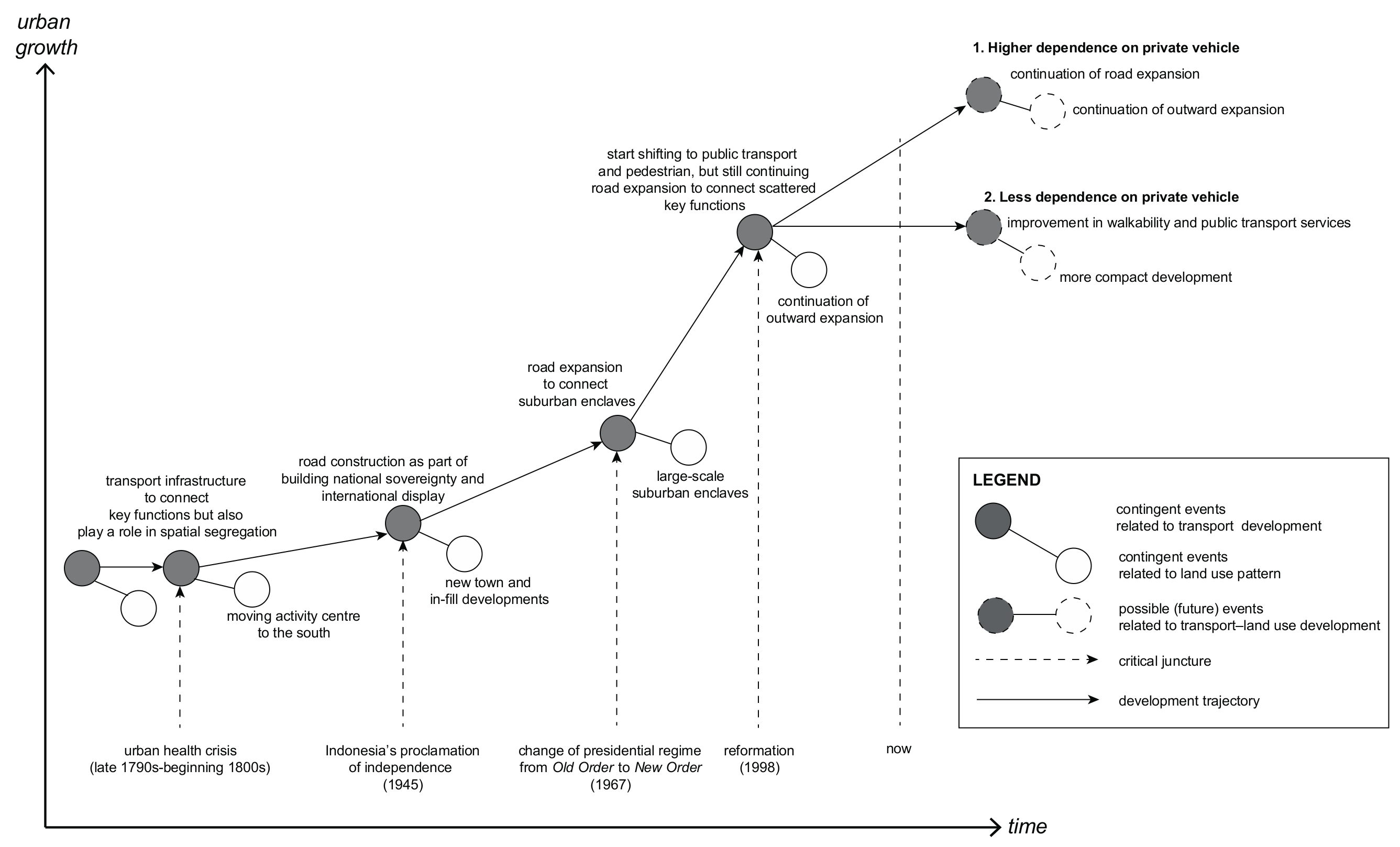
3.1. Path Dependence: Transport–Land Use Policies Impact on Jakarta’s Urban Development
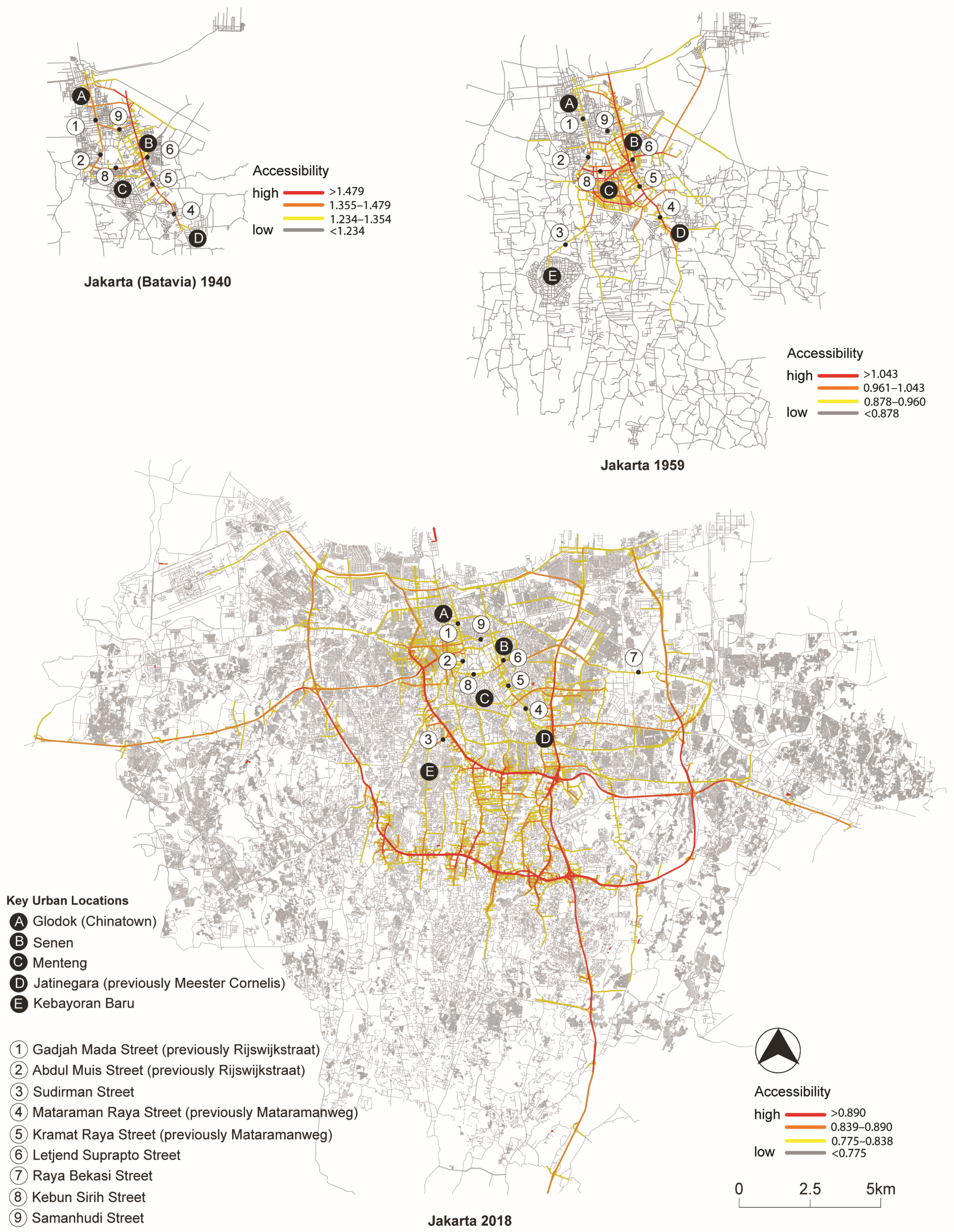
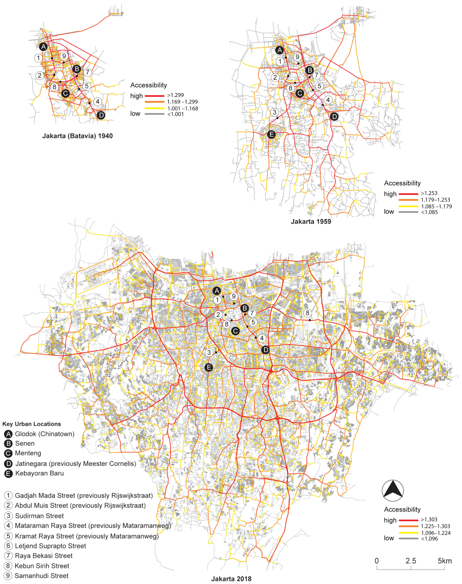
3.2. Jakarta’s Urban Transformation Over Time
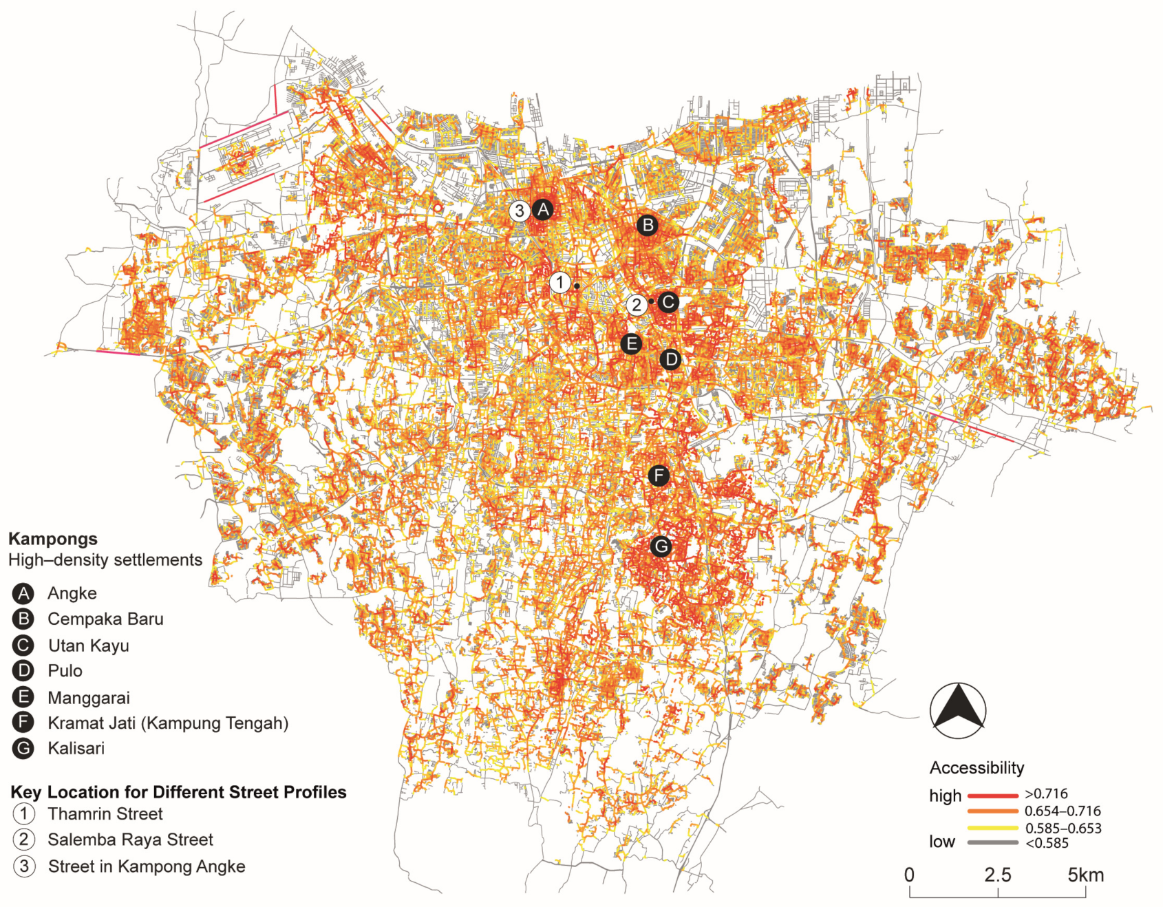
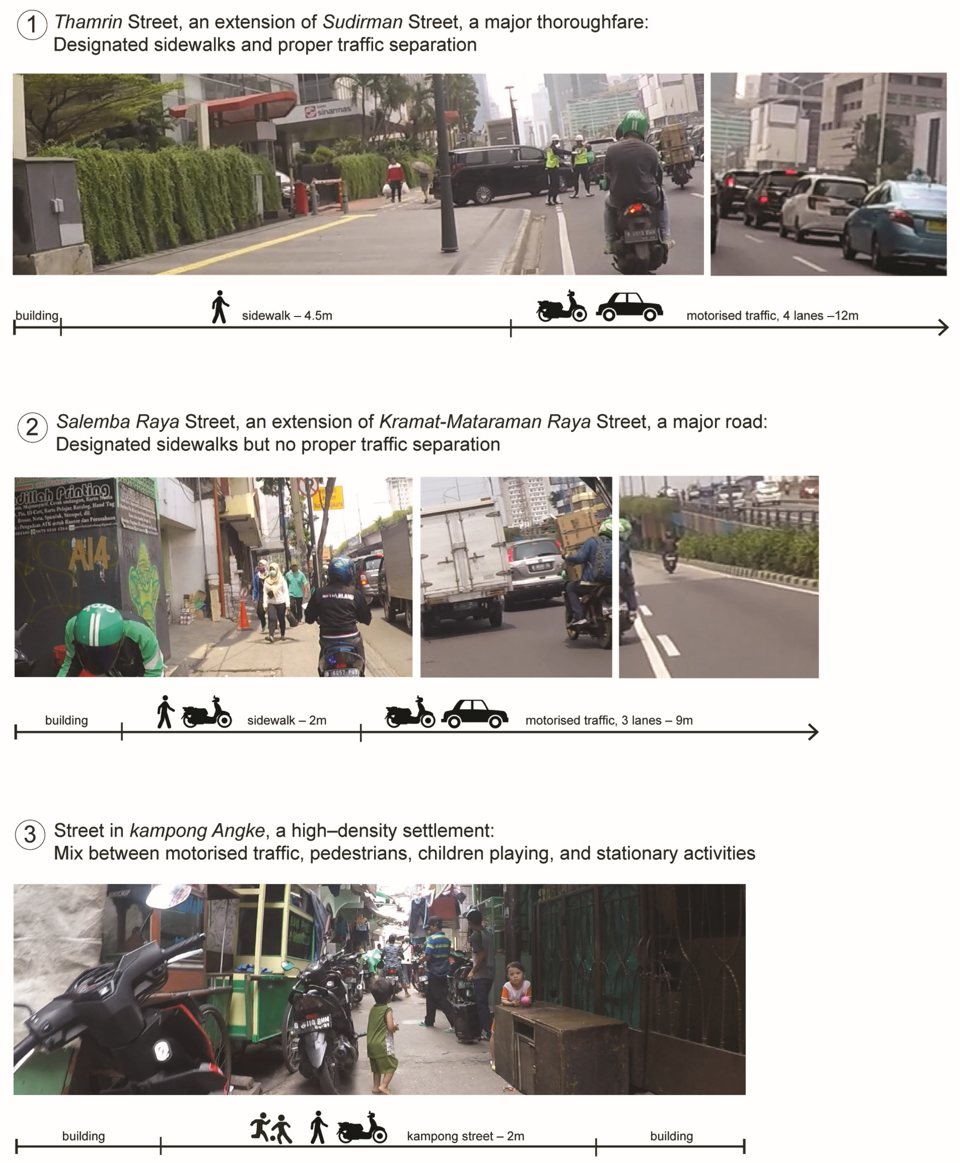
3.3. Present Conditions of Mobility Inequality in Jakarta
4. Discussion
5. Conclusions
Author Contributions
Funding
Conflicts of Interest
References
- Lo, R.H. The city as a mirror: Transport, land use and social change in Jakarta. Urban Stud. 2010, 47, 529–555. [Google Scholar]
- Barter, P.A. Transport, urban structure and ‘lock-in’ in the Kuala Lumpur Metropolitan Area. Int. Dev. Plan. Rev. 2004, 26, 1–24. [Google Scholar] [CrossRef]
- David, P.A. Why are institutions the ‘carriers of history’? Path dependence and the evolution of conventions, organizations and institutions. Struct. Chang. Econ. Dyn. 1994, 5, 205–220. [Google Scholar] [CrossRef]
- Martin, R.; Sunley, P. Path dependence and regional economic evolution. J. Econ. Geogr. 2006, 6, 395–437. [Google Scholar] [CrossRef]
- Sorensen, A. Taking path dependence seriously: An historical institutionalist research agenda in planning history. Plan. Perspect. 2015, 30, 17–38. [Google Scholar] [CrossRef]
- Compendium of Transport Sector Operations in Southeast Asia. Available online: https://www.adb.org/sites/default/files/institutional-document/33705/files/compendium-transport-sector-operations-se-asia.pdf (accessed on 24 June 2019).
- Pojani, D.; Stead, D. Sustainable urban transport in the developing world: Beyond megacities. Sustainability 2015, 7, 7784–7805. [Google Scholar] [CrossRef]
- Susilo, Y.O.; Joewono, T.B.; Santosa, W.; Parikesit, D. A reflection of motorization and public transport in Jakarta Metropolitan Area. IATSS Res. 2007, 31, 59–68. [Google Scholar] [CrossRef]
- Yagi, S.; Nobel, D.; Kawaguchi, H. Time series comparison of models of auto and motorcycle ownership and mode choice in a changing transportation environment: Jakarta, Indonesia. Transp. Res. Rec. J. Transp. Res. Board 2012, 2317, 40–50. [Google Scholar] [CrossRef]
- Wachs, M.; Kumagai, T.G. Physical accessibility as a social indicator. Socio-Econ. Plan. Sci. 1973, 7, 437–456. [Google Scholar] [CrossRef]
- Kwan, M.-P.; Schwanen, T. Geographies of Mobility. Ann. Am. Assoc. Geogr. 2016, 106, 243–256. [Google Scholar] [CrossRef]
- Ferreira, A.; Batey, P.; Brömmelstroet, M.T.; Bertolini, L. Beyond the dilemma of mobility: Exploring new ways of matching intellectual and physical mobility. Environ. Plan. A 2012, 44, 688–704. [Google Scholar] [CrossRef]
- Dodson, J.; Gleeson, B.; Evans, R.; Sipe, N. Investigating the social dimensions of transport disadvantage II: From concepts to methods through an empirical case study. Urban Policy Res. 2007, 25, 63–89. [Google Scholar] [CrossRef]
- Delbosc, A.; Currie, G. The spatial context of transport disadvantage, social exclusion and well-being. J. Transp. Geogr. 2011, 19, 1130–1137. [Google Scholar] [CrossRef]
- Maimunah, S.; Kaneko, S. Commuters’ behaviors and attitudes toward current transport mode chosen. J. Int. Dev. Coop. 2016, 22, 91–105. [Google Scholar]
- Church, A.; Frost, M.; Sullivan, K. Transport and social exclusion in London. Transp. Policy 2000, 7, 195–205. [Google Scholar] [CrossRef]
- Kenyon, S.; Lyons, G.; Rafferty, J. Transport and social exclusion: Investigating the possibility of promoting inclusion through virtual mobility. J. Transp. Geogr. 2002, 10, 207–219. [Google Scholar] [CrossRef]
- Stanley, J.K.; Hensher, D.A.; Stanley, J.R.; Vella-Brodrick, D. Mobility, social exclusion and well being: Exploring the links. Transp. Res. Part A 2011, 45, 789–801. [Google Scholar] [CrossRef]
- Richardson, T.; Jensen, O.B. How mobility systems produce inequality: Making mobile subject types on the Bangkok sky train. Built Environ. 2008, 34, 218–231. [Google Scholar] [CrossRef]
- Soja, E.W. The city and spatial justice. Justice Spat./Spat. Justice 2009, 1, 1–5. [Google Scholar]
- Sheller, M. Racialized mobility transitions in Philadelphia: Connecting urban sustainability and transport justice. City Soc. 2015, 27, 70–91. [Google Scholar] [CrossRef]
- Newman, P.; Kenworthy, J. Sustainable urban form: The big picture. In Achieving Sustainable Urban Form, 1st ed.; Williams, K., Burton, E., Jenks, M., Eds.; E & FN Spon: London, UK, 2000; pp. 109–113. [Google Scholar]
- Newman, P.; Kenworthy, J. The End of Automobile Dependence: How Cities Are Moving Beyond Car-Based Planning, 1st ed.; Island Press: Washington, DC, USA, 2015; pp. 67–76. [Google Scholar]
- Senbil, M.; Zhang, J.; Fujiwara, A. Motorization in Asia: 14 Countries and three metropolitan areas. IATSS Res. 2007, 31, 46–58. [Google Scholar] [CrossRef]
- Chin, H.-C. Sustainable Urban Mobility in South-Eastern Asia and the Pacific. Global Report on Human Settlements. Regional Study Prepared for Global Report on Human Settlements 2013. Available online: https://unhabitat.org/wp-content/uploads/2013/06/GRHS.2013.Regional.South_.Eastern.Asia_.and_.Pacific.pdf (accessed on 24 June 2019).
- Pink, S. Walking with video. Vis. Studio 2007, 22, 240–252. [Google Scholar] [CrossRef]
- Winarso, J.; Hudalah, D.; Firman, T. Peri-urban transformation in the Jakarta metropolitan area. Habitat Int. 2015, 49, 221–229. [Google Scholar] [CrossRef]
- Rau, H.; Fahy, F. Sustainability research in the social sciences—Concepts, methodologies and the challenge of interdisciplinarity. In Methods of Sustainability Research in the Social Sciences, 1st ed.; Fahy, F., Rau, H., Eds.; Sage: New Delhi, India, 2013; p. 9. [Google Scholar]
- Punch, K.F. Introduction to Social Research: Quantitative and Qualitative Approaches, 3rd ed.; SAGE: London, UK, 2014; pp. 93–112. [Google Scholar]
- Pflieger, G.; Kaufmann, V.; Pattaroni, L.; Jemelin, C. How does urban public transport change cities? Correlations between past and present transport and urban planning policies. Urban Stud. 2009, 46, 1421–1437. [Google Scholar] [CrossRef]
- Tasan-Kok, T. Analysing path dependence to understand divergence: Investigating hybrid neo-liberal urban transformation processes in Turkey. Eur. Plan. Stud. 2015, 23, 2184–2209. [Google Scholar] [CrossRef]
- Cervero, R. Linking urban transport and land use in developing countries. J. Transp. Land Use 2013, 6, 7–24. [Google Scholar] [CrossRef] [Green Version]
- Pierson, P. Increasing return, path dependence, and the study of politics. Am. Polit. Sci. Rev. 2000, 94, 251–267. [Google Scholar] [CrossRef]
- Low, N.; Gleeson, B.; Rush, E. A multivalent conception of path dependence: The case of transport planning in metropolitan Melbourne, Australia. Environ. Sci. 2005, 2, 39–41. [Google Scholar] [CrossRef]
- Low, N.; Astle, R. Path dependence in urban transport: An institutional analysis of urban passenger transport in Melbourne, Australia, 1956–2006. Transp. Policy 2009, 16, 47–58. [Google Scholar] [CrossRef]
- Urry, J. Governance, flows, and the end of the car system? Glob. Environ. Chang. 2008, 18, 343–349. [Google Scholar] [CrossRef]
- Can, I.; Ince, I.; Yamu, C. The rationale behind growth patterns: Socio-spatial configuration of Izmir, Turkey 1700s–2010. In Proceedings of the 10th International Space Syntax Symposium, London, UK, 13–17 July 2015. [Google Scholar]
- Aleksandrowicz, O.; Yamu, C.; van Nes, A. The socio-spatial development of Jaffa-Tel-Aviv: The emergence and fade-away of ethnic divisions and distinctions. In Proceedings of the 11th Space Syntax Symposium, Lisbon, Portugal, 3–7 July 2017. [Google Scholar]
- Dalton, R.C. The secret is to follow your nose: Route path selection and angularity. Environ. Behav. 2003, 35, 107–131. [Google Scholar] [CrossRef]
- Hillier, B.; Iida, S. Network and psychological effects in urban movement. In Spatial Information Theory, Proceedings of the International Conference on Spatial Information Theory (COSIT), New York, NY, USA, 14–18 September 2005; Cohn, A.G., Mark, D.M., Eds.; Springer: Berlin, Germany, 2005; pp. 553–563. [Google Scholar]
- Hillier, B. Studying cities to learn about minds: Some possible implications of space syntax for spatial cognition. Environ. Plan. B Plan. Des. 2012, 39, 12–32. [Google Scholar] [CrossRef]
- Van Nes, A.; Yamu, C. Space syntax—A method to measure urban space related to social, economic and cognitive factors. In The Virtual and the Real in Planning and Urban Design: Perspectives, Practices and Applications, 1st ed.; Yamu, C., Poplin, A., Devisch, O., de Roo, G., Eds.; Routledge: Oxon, UK, 2018; pp. 136–150. [Google Scholar]
- Griffiths, S. Temporality in Hillier and Hanson’s theory of spatial description: Some implications of historical research for Space Syntax. J. Space Syntax 2011, 2, 73–96. [Google Scholar]
- Griffiths, S. The use of space syntax in historical research: Current practice and future possibilities. In Proceedings of the 8th International Space Syntax Symposium, Santiago, Chile, 3–6 January 2012. [Google Scholar]
- Griffiths, S.; Dhanani, A.; Ellul, C.; Haklay, M.; Jeevendrampillai, D.; Nikolova, N.; Rickles, P.; Vaughan, L. Using space syntax and historical land-use data to interrogate narratives of high-street ‘decline’ in two Greater London suburbs. In Proceedings of the 9th International Space Syntax Symposium, Seoul, Korea, 31 October–3 November 2013. [Google Scholar]
- Turner, A.; Penn, A.; Hillier, B. An algorithmic definition of the axial map. Environ. Plan. B Plan. Des. 2005, 32, 425–444. [Google Scholar] [CrossRef]
- Turner, A. From axial to road-centre lines: A new representation for space syntax and a new model of route choice for transport network analysis. Environ. Plan. B Urban Anal. City Sci. 2007, 34, 539–555. [Google Scholar] [CrossRef]
- Hillier, B.; Yang, T.; Turner, A. Normalising least angle choice in Depthmap and how it opens up new perspectives on the global and local analysis of city space. J. Space Syntax 2012, 3, 155–193. [Google Scholar]
- Guo, H.; Wang, W.; Guo, W.; Jiang, X.; Bubb, H. Reliability analysis of pedestrian safety crossing in urban traffic environment. Saf. Sci. 2012, 50, 968–973. [Google Scholar] [CrossRef]
- Van der Horst, R.A.; de Goede, M.; de Hair-Buijssen, S.; Methorst, R. Traffic conflicts on bicycle paths: A systematic observation of behaviour from video. Accid. Anal. Prev. 2014, 62, 358–368. [Google Scholar] [CrossRef]
- Karim, M. (Ed.) Ekspedisi Ciliwung: Laporan Jurnalistik Kompas, Mata Air, Air Mata, 1st ed.; Penerbit Buku Kompas: Jakarta, Indonesia, 2009; p. 89. [Google Scholar]
- Indonesia proclaimed its independence in 1945, however the Netherlands recognises Indonesia’s independence in 1949 referring to the formal territorial handover that took place during the Dutch-Indonesia Round Table Negotiation that year. The state of Indonesia between 1945–1949 is still on debate until now (see for example Houben, V.J.H. A torn soul: The Dutch public discussion on the colonial past in 1995). Indonesia 1997, 63, 47–66.
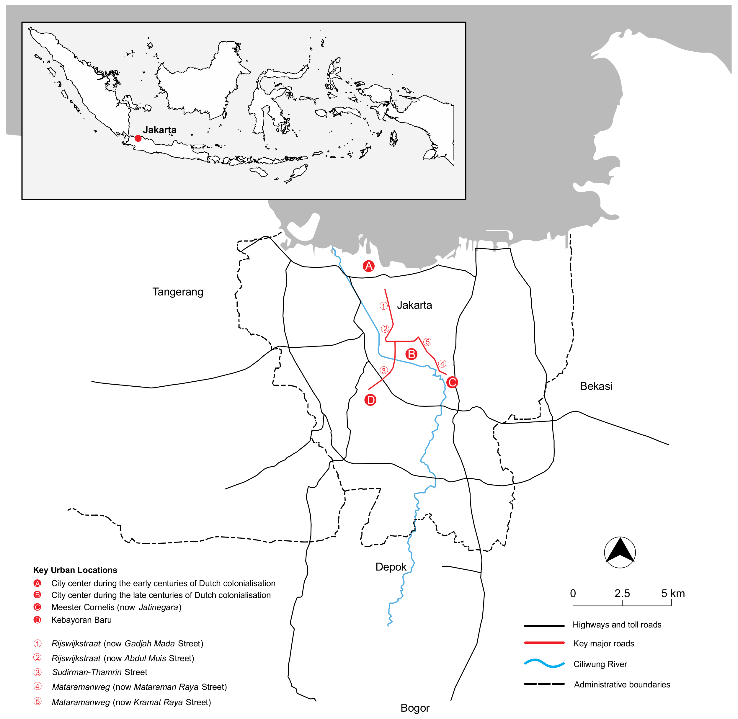
- Cobban, J.L. Geographical notes on the first two centuries of Djakarta. J. Malays. Branch R. Asiat. Soc. 1971, 44, 108–150. [Google Scholar]
- Jumlah Penduduk dan Rasio Jenis Kelamin Menurut Kabupaten/Kota di Provinsi DKI Jakarta. 2015. Available online: https://jakarta.bps.go.id/statictable/2017/01/30/137/jumlah-penduduk-dan-rasio-jenis-kelamin-menurut-kabupaten-kota-di-provinsi-dki-jakarta-2015.html (accessed on 24 June 2019).
- Firman, T. New town development in Jakarta Metropolitan Region: A perspective of spatial segregation. Habitat Int. 2004, 28, 349–368. [Google Scholar] [CrossRef]
- Merrillees, S. Jakarta: Portraits of a Capital 1950–1980, 1st ed.; Equinox: Singapore, 2008; p. 39. [Google Scholar]
- Cybriwsky, R.; Ford, L.R. City Profile: Jakarta. Cities 2001, 18, 199–210. [Google Scholar] [CrossRef]
- Maru, R.; Ahmad, S. The relationship between land use changes and the urban heat island phenomenon in Jakarta, Indonesia. Adv. Sci. Lett. 2015, 21, 150–152. [Google Scholar] [CrossRef]
- Alzamil, W. The urban features of informal settlements in Jakarta, Indonesia. Data Brief 2017, 15, 993–999. [Google Scholar] [CrossRef] [PubMed]
- Arif, F.A. Transport planning in Jakarta. Urban Policy Res. 2002, 20, 371–389. [Google Scholar] [CrossRef]
- Burke, P.J.; Batsuuri, T.; Yudhistira, M.H. Easing the traffic: The effects of Indonesia’s fuel subsidy reforms on toll-road travel. Transp. Res. Part A Policy Pract. 2017, 105, 167–180. [Google Scholar] [CrossRef]
- Hillier, B. Spatial sustainability in cities: Organic patterns and sustainable forms. In Proceedings of the 7th International Space Syntax Symposium, Stockholm, Sweden, 8–11 June 2009. [Google Scholar]
- Soliha, E. Analisis Industri Ritel di Indonesia. Jurnal Bisnis dan Ekonomi 2008, 15, 128–142. [Google Scholar]
- Kusno, A. Power and time turning: The capital, the state and the kampung in Jakarta. Int. J. Urban Sci. 2015, 19, 53–63. [Google Scholar] [CrossRef]
- Leitner, H.; Sheppard, E. From kampungs to condos? Contested accumulations through displacement in Jakarta. Environ. Plan. A Econ. Space 2018, 50, 437–456. [Google Scholar] [CrossRef]
- Sedyawati, E.; Rahardjo, S.; Johan, I.M.; Manilet-Ohorella, G.A. Sejarah Kota Jakarta 1950–1980, 1st ed.; Departemen Pendidikan dan Kebudayaan: Jakarta, Indonesia, 1986; p. 29. [Google Scholar]
- Budiarto, L. Dwellers and strangers: Socio-cultural entity, space use, and spatial configuration in kampung settlements of Jakarta, Indonesia. In Proceedings of the 4th International Space Syntax Symposium, London, UK, 17–19 June 2003. [Google Scholar]
- Karndacharuk, A.; Wilson, D.J.; Dunn, R. A review of the evolution of shared (street) space concepts in urban environments. Transp. Rev. 2014, 34, 190–220. [Google Scholar] [CrossRef]
- Zulkifli, M.; Hino, Y.; Pattinaja, A.M.; Tjahjani, I. Limitation of walking facilities in Jakarta: A visual analysis on actual condition and user’s perception. In Proceedings of the 8th International Conference of Eastern Asia Society for Transportation Studies, Surabaya, Indonesia, 16–19 November 2009. [Google Scholar]
- Leather, J.; Fabian, H.; Gota, S.; Mejia, A. Walkability and Pedestrian Facilities in Asian Cities: State and Issues; ADB Sustainable Development Working Paper Series, No. 17; Asian Development Bank: Manila, Philippines, 2011. [Google Scholar]
- ASEAN SDGs Frontrunner Cities Programme. Available online: https://sustainabledevelopment.un.org/partnership/?p=29570 (accessed on 24 June 2019).
- ASEAN Regional Strategy on Sustainable Land Transport. Available online: https://asean.org/storage/2019/03/ASEAN-Regional-Strategy-for-Sustainable-Land-Transport-Final.pdf (accessed on 24 June 2019).
- Rau, R.; Goggins, G.; Fahy, F. From invisibility to impact: Recognising the scientific and societal relevance of interdisciplinary sustainability research. Res. Policy 2018, 47, 266–276. [Google Scholar] [CrossRef]
- Song, Y.; Tan, Y.; Song, Y.; Wu, P.; Cheng, J.C.P.; Kim, M.J.; Wang, X. Spatial and temporal variations of spatial population accessibility to public hospitals: A case study of rural–urban comparison. GiSci. Remote Sens. 2018, 55, 718–744. [Google Scholar] [CrossRef]
- Barone, R.E.; Giuffrè, T.; Siniscalchi, S.M.; Morgano, M.A.; Tesoriere, G. Architecture for parking management in smart cities. IET Intell. Transp. Syst 2013, 8, 445–452. [Google Scholar] [CrossRef]


| 1940 Model | 1959 Model | 2018 Model | |||||
|---|---|---|---|---|---|---|---|
| NAIN | NACH | NAIN | NACH | NAIN | NACH | ||
| Numbers of street segments | 5783 | 11,335 | 546,282 | ||||
| Connectivity (average) | 4.214 | 3.947 | 2.978 | ||||
| System minimum | 0.385 | 0.000 | 0.309 | 0.000 | 0.216 | 0.000 | |
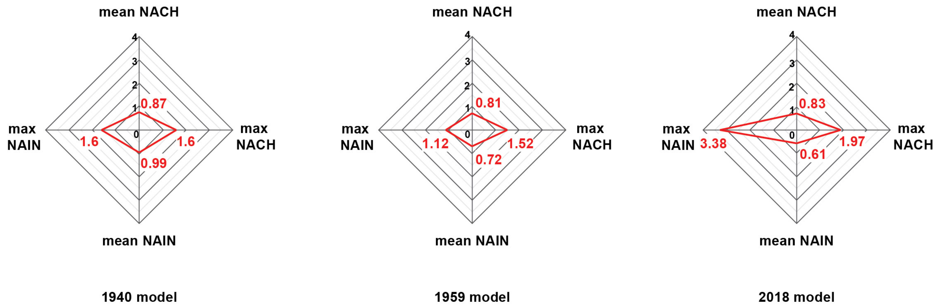
| System average | 0.986 | 0.875 | 0.725 | 0.811 | 0.610 | 0.829 | |
| System maximum | 1.599 | 1.602 | 1.124 | 1.522 | 3.377 | 1.974 | |
| 1 | Gadjah Mada Street (previously Rijswijkstraat) | 1.466 | 1.546 | 0.949 | 1.423 | 0.831 | 1.282 |
| 2 | Abdul Muis Street (previously Rijswijkstraat) | 1.402 | 1.496 | 0.993 | 1.415 | 0.816 | 1.134 |
| 3 | Sudirman Street | - | - | 0.944 | 1.477 | 0.846 | 1.324 |
| 4 | Mataraman Raya Street (previously Mataramanweg) | 1.405 | 1.510 | 1.070 | 1.508 | 0.833 | 1.327 |
| 5 | Kramat Raya Street (previously Mataramanweg) | 1.532 | 1.596 | 1.122 | 1.517 | 0.838 | 1.312 |
| 6 | Letjend Suprapto Street | 1.018 | 1.318 | 0.930 | 1.469 | 0.842 | 1.184 |
| 7 | Raya Bekasi Street | - | - | - | - | 0.750 | 1.386 |
| 8 | Kebun Sirih Street | 1.410 | 1.427 | 1.102 | 1.470 | 0.811 | 1.257 |
| 9 | Samanhudi Street | 1.392 | 1.375 | 0.845 | 1.253 | 0.830 | 1.376 |
© 2019 by the authors. Licensee MDPI, Basel, Switzerland. This article is an open access article distributed under the terms and conditions of the Creative Commons Attribution (CC BY) license (http://creativecommons.org/licenses/by/4.0/).
Share and Cite
Hidayati, I.; Yamu, C.; Tan, W. The Emergence of Mobility Inequality in Greater Jakarta, Indonesia: A Socio-Spatial Analysis of Path Dependencies in Transport–Land Use Policies. Sustainability 2019, 11, 5115. https://doi.org/10.3390/su11185115
Hidayati I, Yamu C, Tan W. The Emergence of Mobility Inequality in Greater Jakarta, Indonesia: A Socio-Spatial Analysis of Path Dependencies in Transport–Land Use Policies. Sustainability. 2019; 11(18):5115. https://doi.org/10.3390/su11185115
Chicago/Turabian StyleHidayati, Isti, Claudia Yamu, and Wendy Tan. 2019. "The Emergence of Mobility Inequality in Greater Jakarta, Indonesia: A Socio-Spatial Analysis of Path Dependencies in Transport–Land Use Policies" Sustainability 11, no. 18: 5115. https://doi.org/10.3390/su11185115