1. Introduction
There are two categories of natural disasters that affect Taiwan: climatic-related disasters, such as typhoons and floods, and geological hazards, which include mass movements or slope failures and earthquakes. The historical records reveal that from 1958 to 2007, 270 natural disaster events occurred in Taiwan, including typhoons (71.1%), flooding (15%), earthquakes (8.5%), torrential rainfall (2.2%), windstorms (1.5%), mountain flooding (0.7%), and landslides (0.7%) [
1]. In particular, 89% were related to heavy rainfall, and 97% were directly or indirectly related to landslides. Thus, typhoon-induced landslides pose the greatest threat to southern Taiwan [
2].
Typhoons are common meteorological events during the summer and fall months in Taiwan. Taiwan is located at 23–25° N, which places the island in the pathway of western North Pacific tropical cyclones [
3]. Approximately 30 tropical cyclones form annually, with an average of 4.5 events affecting Taiwan and an average of 1.8 making landfall [
4]. Warm, moist air produced by typhoon formation causes continuous torrential rain on windward-sloping terrain [
5,
6]. As a result, heavy rainfall persists even after a typhoon leaves Taiwan [
7]. Moreover, typhoons often engage in tremendous changes in motion and structure when approaching or moving across an island [
8,
9], making their paths difficult to forecast.
The direct impact of natural disasters on the indigenous people of Taiwan is very apparent, as the majority reside in the highlands and mountainous regions. The mountainous regions of southern Taiwan are the homelands of the Rukai, Bunan, and Paiwan tribes. These mountain groups are continuously exposed to increased risk as a result of residing in such hazard-prone environments. For example, Typhoon Morakot caused significant destruction in the indigenous communities in the highlands, severely damaging property and incurring heavy death tolls [
10,
11]. Moreover, post-disaster reconstruction initiatives and assistance typically do not address the actual needs of such communities [
12].
The term “sustainable development” is a common phrase used in relation to the economic, social, and environmental development taking place in society. The Brundtland Commission [
13] defines sustainable development as “development that meets the needs of the present without compromising the ability of future generations to meet their own needs”, which is the most widely accepted definition. The vision of “sustainable mountain communities” in Taiwan has garnered the attention of local and national governments, as well as non-governmental organizations [
14]. In practice, the term “sustainability” has become a catch phrase for government involvement in community development [
15]. Moreover, the encroachment of development—aiming to improve the local economy—into the highland areas of southern Taiwan has, in turn, created negative environmental consequences. Such practices include land use alterations on steep sloping terrain for agricultural development and regulated tourism development, such as resort construction.
Devastating events such as Typhoon Morakot reveal the complexities of preparing for natural disasters in a sustainable way. Mountain communities must balance the need to minimize the harmful impact of natural disasters on their citizens while finding ways to utilize their natural wealth to improve the local economy; indeed, increased agricultural production and tourism can bring many economic benefits to such communities [
16]. The International Union of Geodesy and Geophysics (IUGG)’s Commission on Geophysical Risk and Sustainability has identified the need for integration of knowledge concerning environmental, social, and economic processes [
17]. Furthermore, the integration of such diverse data streams can improve the understanding of the natural phenomena associated with disasters, develop prediction model capabilities, and generate and analyze timely and accurate information needed by decision makers and the public. Therefore, more multidisciplinary research programs should be developed to facilitate this goal.
The combination of Taiwan’s complex geology and unpredictable weather creates conditions for extreme natural disaster events to occur on a fairly regular basis. The island is often the victim of natural hazards, causing loss of life or immeasurable property damage. Small remote villages typically have poorly developed economies that rely on agriculture and tourism and have limited capacities for resilience in the wake of such extreme events. Natural disasters can severely disrupt the tourism industry, which is heavily dependent on daytrips made by out-of-community visitors. Similarly, agricultural activity can be significantly impaired or destroyed by flooding or landslides. With such limited economic diversification, mountain communities have low capacities to adapt to disturbances caused by natural hazards. Therefore, such communities remain unsustainably vulnerable to the impacts of future natural disasters. The loss of economic opportunities such as job creation and business development further exasperate social problems, including alcohol abuse, depression, anxiety, and domestic violence [
18]. The combination of poor environmental, economic, and social conditions creates a vicious cycle that communities are unable to overcome.
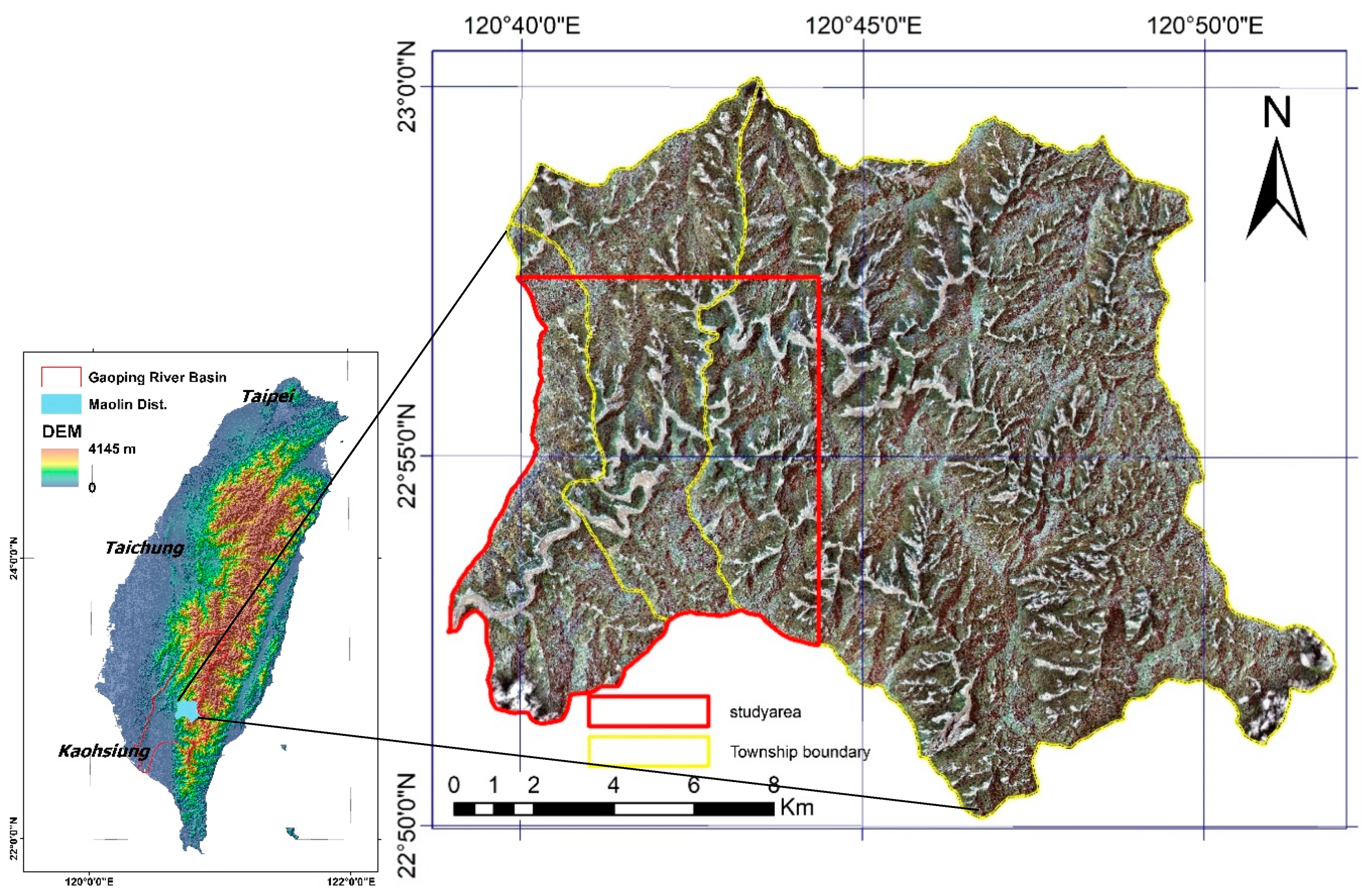
The objectives of this study are as follows: (1) to use a landslide susceptibility index (LSI) map to identify landslide zones; (2); to evaluate the accuracy of the developed LSI map by overlapping Formosat-2 imagery of pre- and post- typhoon events, along with multi-temporal landslide inventory data; (3) to analyze the variations in highly susceptible landslide areas using field investigation; (4) to examine the geomorphic and geologic factors that influence landslides; and (5) to collect—via a pilot survey—and analyze the views of inhabitants of mountainous communities on sustainable development in geohazard-prone areas.
3. Results and Discussion
3.1. Combination of Landslide Inventory and Field Work Analysis
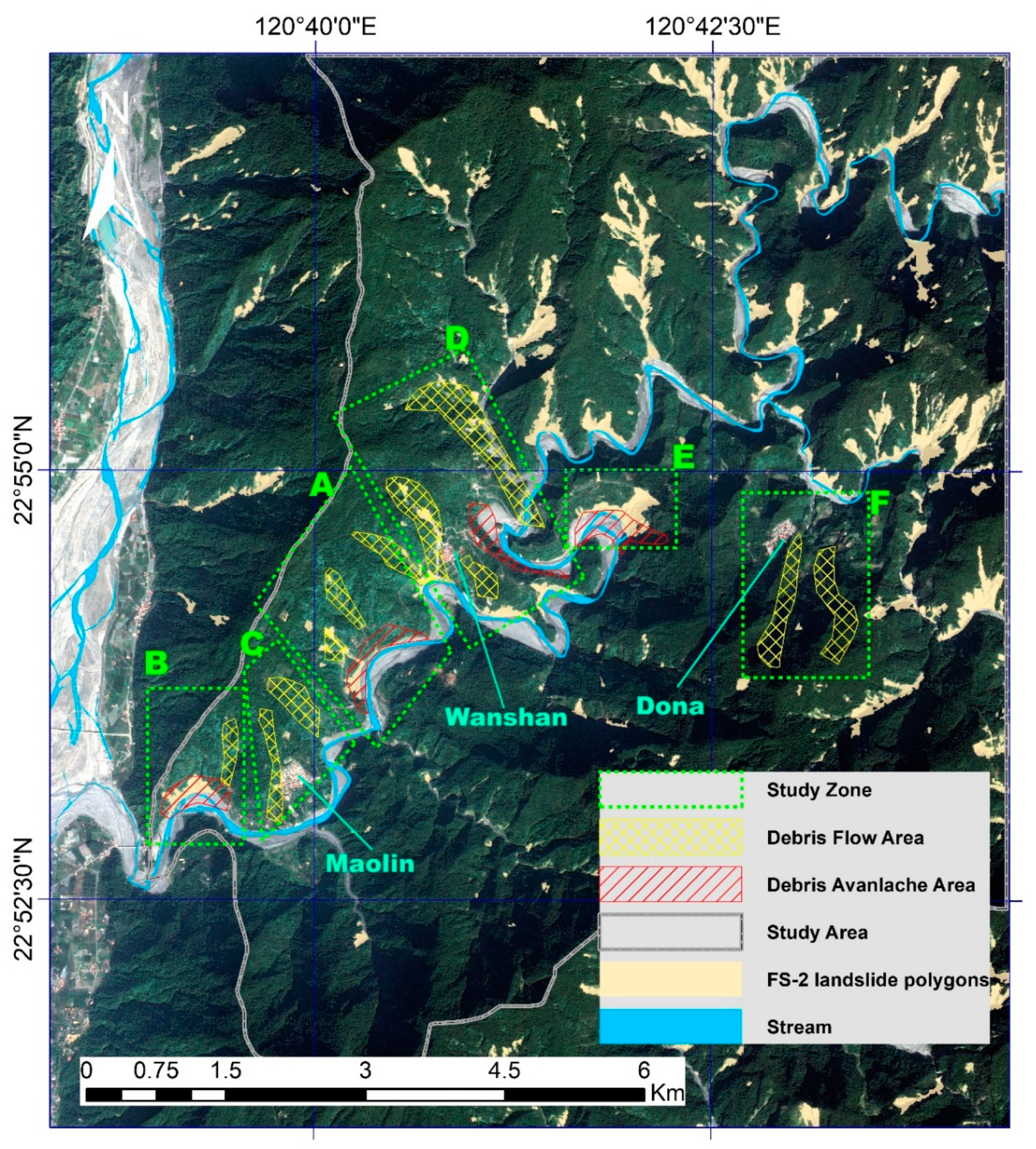
A total of six zones (A, B, C, D, E, and F) were identified to facilitate the analysis of Maolin District (
Supplementary Materials, Figure S1). In zones A and B, slope failures occurred along the base of the river channel near the outer bend. Similarly, the field investigation showed that mass movements also occurred within confined ephemeral gullies. The dominant types of mass movement identified within these zones were debris flows (confined channels) and debris avalanches (unconfined flows). Zone D showed similar processes and geomorphic features to the previously mentioned zones. In zone D, the most significant mass movement was located west of Wanshan Village (
Figure 5). Zone D can be classified as a debris flow-dominated channel based on the basin shape, size, slope, and confined channel. The zone E results show significant mass movements at the base of the outside bend of the Jhoukou River channel. The type of movement was identified as debris avalanche. Interestingly, the location of this movement was directly opposite to the landmark known as Snakehead Mountain. The zone F analysis shows mass movements with confined channels that show possible debris flow characteristics.
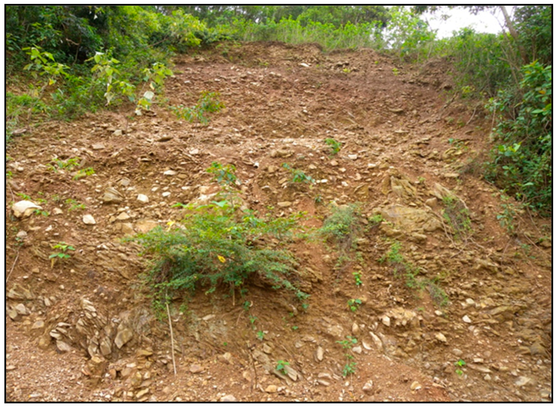
The analysis of the geology and geomorphology of Maolin District reveals that the combination of the two factors played an important role in the frequency and location of the slope failure activity in the study area. The geologic influences indicate that three major rock types are present there: slate, sandstone, and phyllite. Similarly, soil conditions in the study area are generally shallow, poorly sorted, and lacking defined soil horizons. For example, poorly sorted colluvial-type sediments are shown in
Figure 6.
This slope failure was also documented in the landslide inventory analysis (
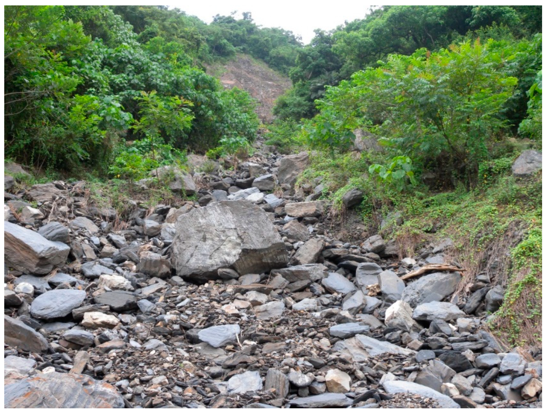
Supplemental Materials, Figure S1) as E1/E2 slope failure. The geologic context also seemed to contribute to the landslide activity of Maolin district. As previously stated, the Lushan formation is primarily composed of highly fractured and deformed bedrock that has been heavily weathered from precipitation. Such geologic conditions allow for unlimited sediment to be supplied to the gullies and channels in the study area. During high precipitation events, the sediment is available to be transported downhill. This pattern is seen throughout Maolin District. Small gullies show little sign of sediment being completely flushed from the channel system.
Figure 7 shows an example of a gully with unlimited sediment availability, which is representative of the condition of the confined gullies in the study area.
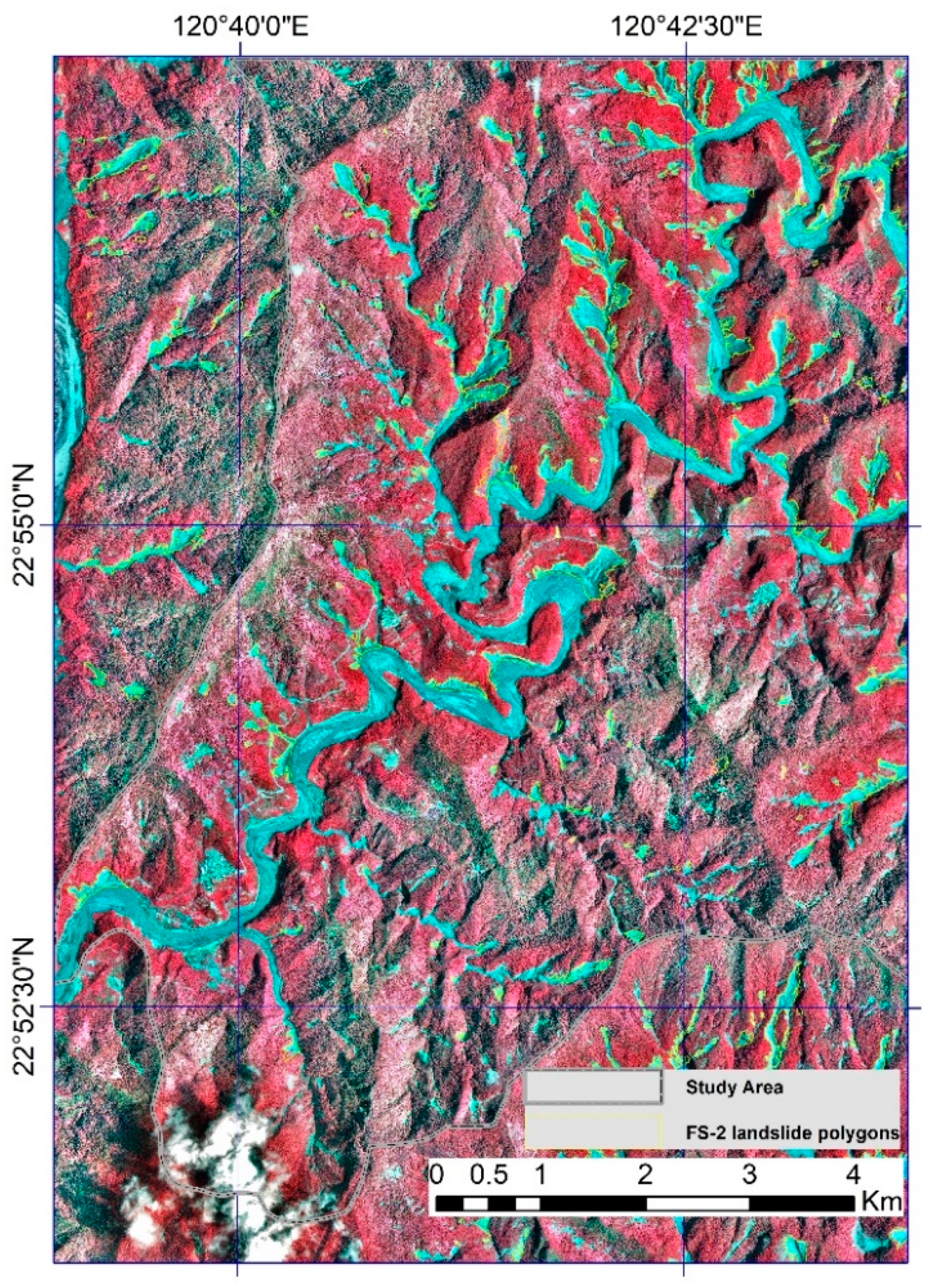
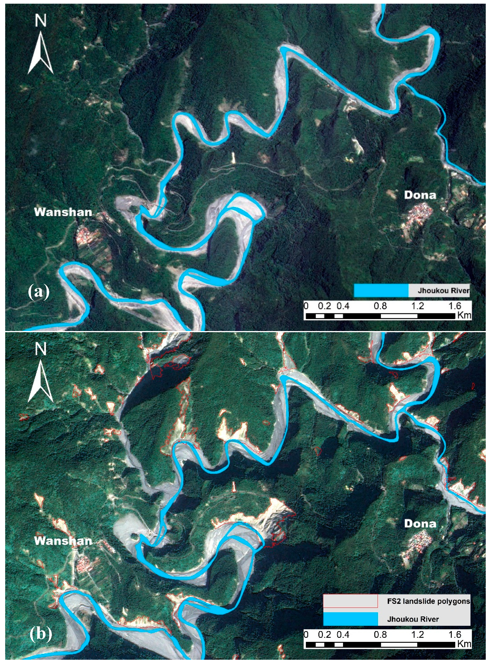
As shown in the imagery analysis (
Supplemental Materials, Figure S1), a significant proportion of landslide activity occurred along the outer bends of meanders along the Jhoukou River. Furthermore,
Figure 8a,b shows the influence of meanders as a geomorphic response to the hydrologic conditions of the Jhoukou River as a result of periods of peak flow, such as during the rainy season or during typhoons. After Typhoon Morakot, significant landslide activity occurred (
Figure 8b) along the outer meander bends. This hydrogeomorphic relationship caused continued incising of the outer banks of the valley walls, thus destabilizing otherwise stable portions upslope from the meander [
31,
32].
Questionnaire Results
The results of the pilot questionnaire (
Supplementary Materials, Table S2) reveal the awareness levels of landslides, disaster prevention knowledge, and perceptions of the concept of sustainability in the community of Maolin District. Most questions were multiple choice and required participants to select one answer; therefore, the total number of replies corresponds to the total number of questionnaires, and the percentage per reply relates to the proportion of the residents surveyed. Other questions allowed for more than one response; therefore, the percentage shown refers to the total number of replies as compared to the total number of possible replies for the individual question. Because the goal of the study is to assess preliminary views, the bias caused by allowing multiple answers is not viewed as significant [
33].
The analysis of the survey results was organized under two topics: “information and awareness”, and “economy and natural capital”. The topics were chosen based on trends found in the initial data analysis. The questions were selected based on their relevance to the previously mentioned topics. A scale was developed to evaluate the “risk to sustainability” for each topic, which allowed for each response to be ranked high, medium, or low. For the topic, “information and awareness”, the following ranking criterion is defined in
Table 1. Generally, residents who lack accurate and reliable information regarding geohazards are less likely to be aware of the danger they face in their community. Improved information sources can further reduce vulnerability and lower the risk of dangerous conditions. For example, residents who know the locations of evacuation shelters and how to receive landslide bulletin updates are more likely to make informed decisions.
With respect to the topic of “economy and natural capital”, the ranking criteria are defined in
Table 2.
Table 3 (
Supplemental Materials, Table S2, question 1) shows that the residents did not have a clear concept of where dangerous landslides or debris flows occur in their community; therefore, weak confidence intervals are reported. Similarly, a high risk to sustainability ranking was assigned to the three most common responses, because the wide breadth of responses indicates that the residents may have had some knowledge of where to obtain this information; however, the source of information may not have been trustworthy. When the residents were asked about how and where to evacuate, a higher confidence interval was reported for the responses that answered “yes” (
Supplemental Materials, Table S2, question 2, response A). This answer was assigned a low risk to sustainability ranking, because it reveals that the residents had knowledge of how to evacuate. However other respondents answered that the government would make evacuation arrangements or that they would simply depend on the government for evacuation. Such answers were assigned a high risk to sustainability ranking due to the fact that responsibility seemed to be shifted away from the individual and towards the government. With respect to the survey question regarding computer access, the results were assigned a low risk to sustainability ranking (
Supplemental Materials, Table S2, question 3).
The high confidence interval indicates that citizens had reliable access to the internet. However, analysis of question 4 indicates that trusted information sources were scarce Many residents chose individuals, such as their husbands, wives, or grandparents, as trusted information sources (
Supplemental Materials, Table S2, question 4). Similarly, the wide range of answers may also indicate that community members had a lack of trust in the government. For example, the offices of the tribal leaders and government representative do not share the same space. Anecdotal evidence from village members reveals that elders were often approached regarding, and had the final say on, decisions related to the conditions of the mountains and river flow during storm events. This may further support the responses recorded for question 4. There was no clear answer when the residents were asked if they understood their evacuation plan. This was also reflected in the confidence interval values for response B of question 4. This response, although not significant, showed the highest CI value of the three choices. These results show that the residents did not think their evacuation plan is good enough and felt there is room for improvement. This is interesting due to the events of Typhoon Morakot, which still would have been fresh in the locals’ minds. It could be assumed that because of this recent disaster, the residents would have shown heightened awareness of their evacuation plan. However, anecdotal evidence indicates that, during Typhoon Morakot, some residents felt that evacuation was not needed and that the outside agencies were more concerned about the residents of Maolin than was necessary. Furthermore, when the residents were asked to identify a safe place to seek refuge during a typhoon, a wide range of responses were recorded. These results also show that the idea of a safe place may be viewed differently by researchers, out-of-community agencies, and government departments than by the local residents. Anecdotal results show that elderly residents felt that their home and the church were safer than the government shelters. This point of view was also observed among the younger community members as well.
The second survey topic, “economy and natural capital” (
Table 4 and
Supplemental Materials, Table S2), shows significant results. A high confidence interval was reported for the question regarding the employment status of the residents. Many of them indicated that they work within their community. This response was assigned a low risk to sustainability ranking. Indeed, the respondents believed that it is a more sustainable solution for the residents to work within their community and to avoid leaving and traveling outside their community for employment. However, the results also show that, in fact, many residents do not have employment. This was ranked a high risk to sustainability. If the residents are unemployed, they are more likely to become dependent on government assistance or, in some cases, have to relocate to a new community. Question 2 focused on the secondary benefits of construction on their community, especially in terms of creating jobs. Surprisingly, a significant number of residents believed that there could be added benefits from construction projects in the study area, such as increased hiring of local residents; however, they did not have personal knowledge of this happening. The third question asked the residents what they hoped for the future of their community. A significant number of residents responded that environmental protection should be a priority for their community. This result was ranked a low risk to sustainability, because there is an underlying understanding within this community that the preservation of cultural and natural resources is necessary. The final question asked the residents how the government could reduce the risk of the landslides that affect their community. Many residents responded that the government needs to increase the budget for construction, road work, and afforestation programs. This was classified as a medium risk to sustainability, because there has already been a significant amount of money spent on projects to improve roadways and infrastructure. Similarly, anecdotal information from the local residents indicates that the current government does not know the local terrain well and that the quality of bridge construction is quite poor compared with that of 50–60 years ago.
3.2. Landslide Susceptibility Index Map Evaluation
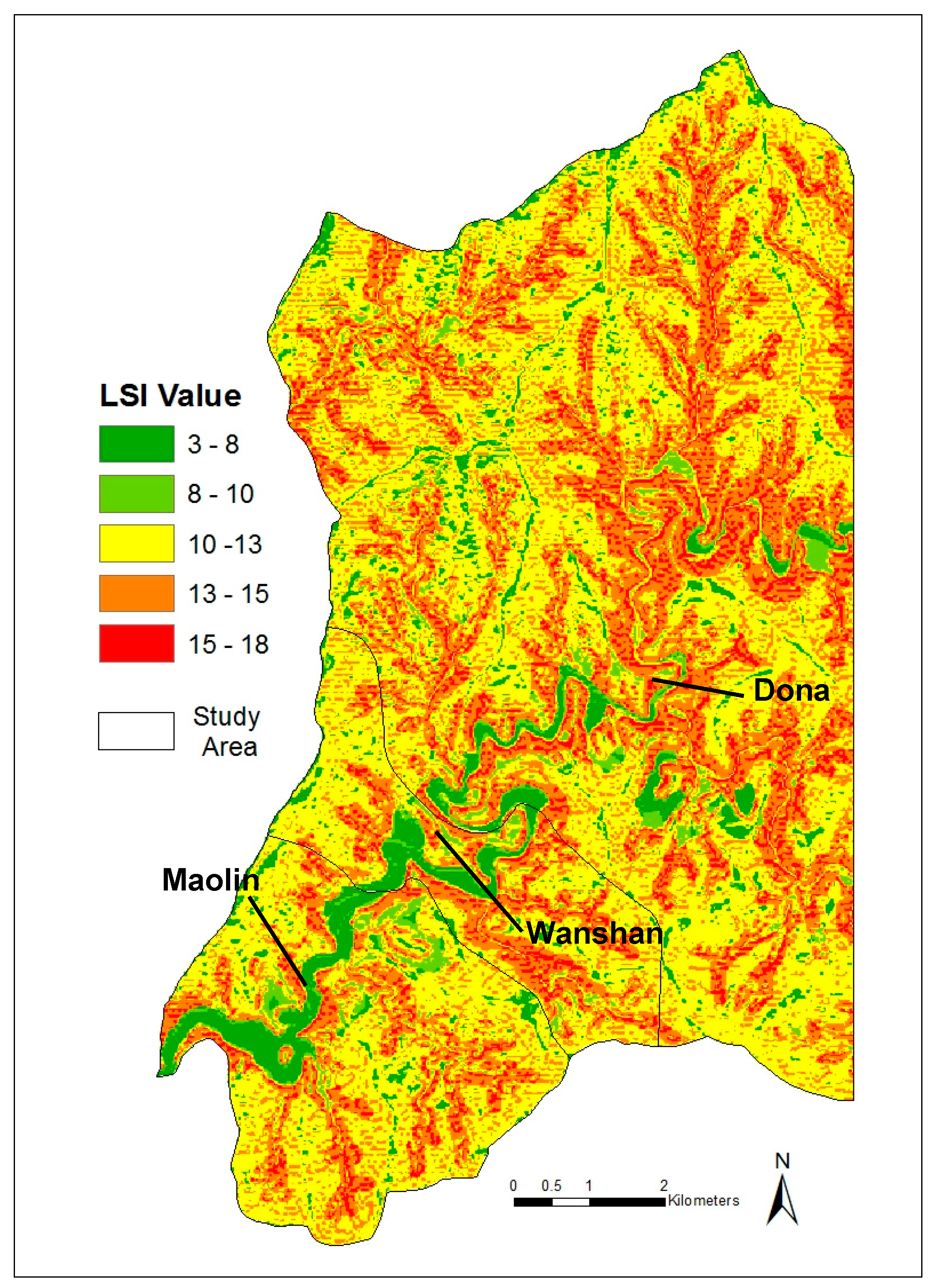
The results of the landslide susceptibility index modeling of Maolin District show that the land conditions of slope, curvature, distance to river, and rock strength strongly influenced hazard-prone areas (
Figure 9). Low LSI values indicated low landslide susceptibility, whereas high values represented areas of high susceptibility. Furthermore, very low (dark green 3–8) to low (green 8–10) LSI values occurred along the riverbed, which corresponded with the low slope gradient found along the base of the Jhoukou River channel. The very low to low LSI values followed a pronounced meander pattern as the river drained to the southwest. Similarly, in the upper reaches, very low to low LSI values were confined to very narrow sections of the river channel; however, as the river drained to the southwest, the river channel widened, as did the meander, which created a broad channel morphology. Medium LSI values (yellow 10–13) dominated the study area model. Such values were located in hilly terrain away from the main river channel. Similarly, medium values occupied the mountain ridge lines that run parallel to the drainage pattern of the study area. High (orange 13–15) to very high (red 15–18) LSI values were located in areas where steep gullies were present. In the upper reaches of the basin, there was a dendritic pattern visible in relation to the high to very high LSI values. Further investigation indicates that such a pattern corresponded with steep first- or second-order channels found in this portion of the study area. Importantly, high to very high LSI values were found along the margin of very low to low values, as well as near the inner and outer bend of meanders along the Jhoukou River channel.
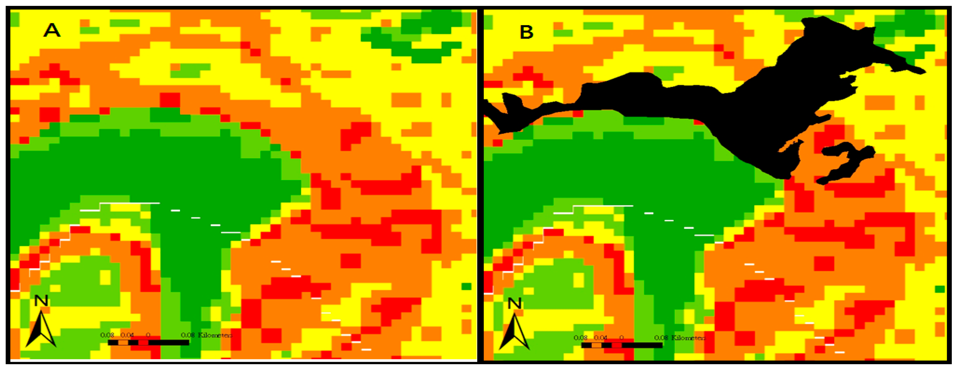
Moreover, this was also seen when comparative analysis of the LSI map and landslide inventory results were conducted (
Supplemental Materials, Figure S2). For example,
Figure 10 shows the Jhoukou River channel (green) with a low LSI value. Along the outer bend of the river, the section was classified as high to very high susceptibility (
Figure 10a). A landslide polygon was added (
Figure 10b) from the landslide inventory results of 2011 to show that undercutting from the meander caused further upslope instability in zones classified as low to medium susceptibility.
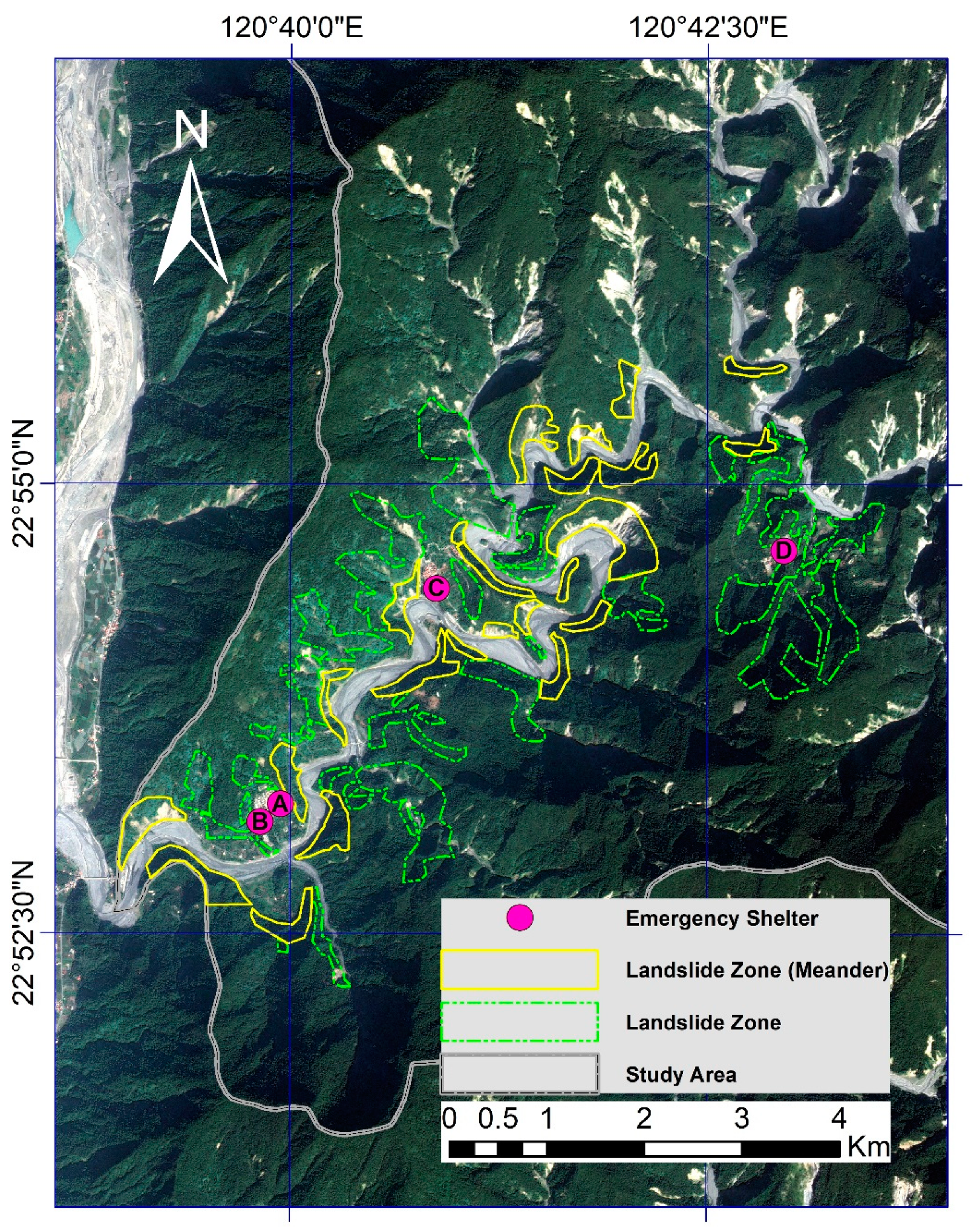
3.3. Landslide Zone Map Results
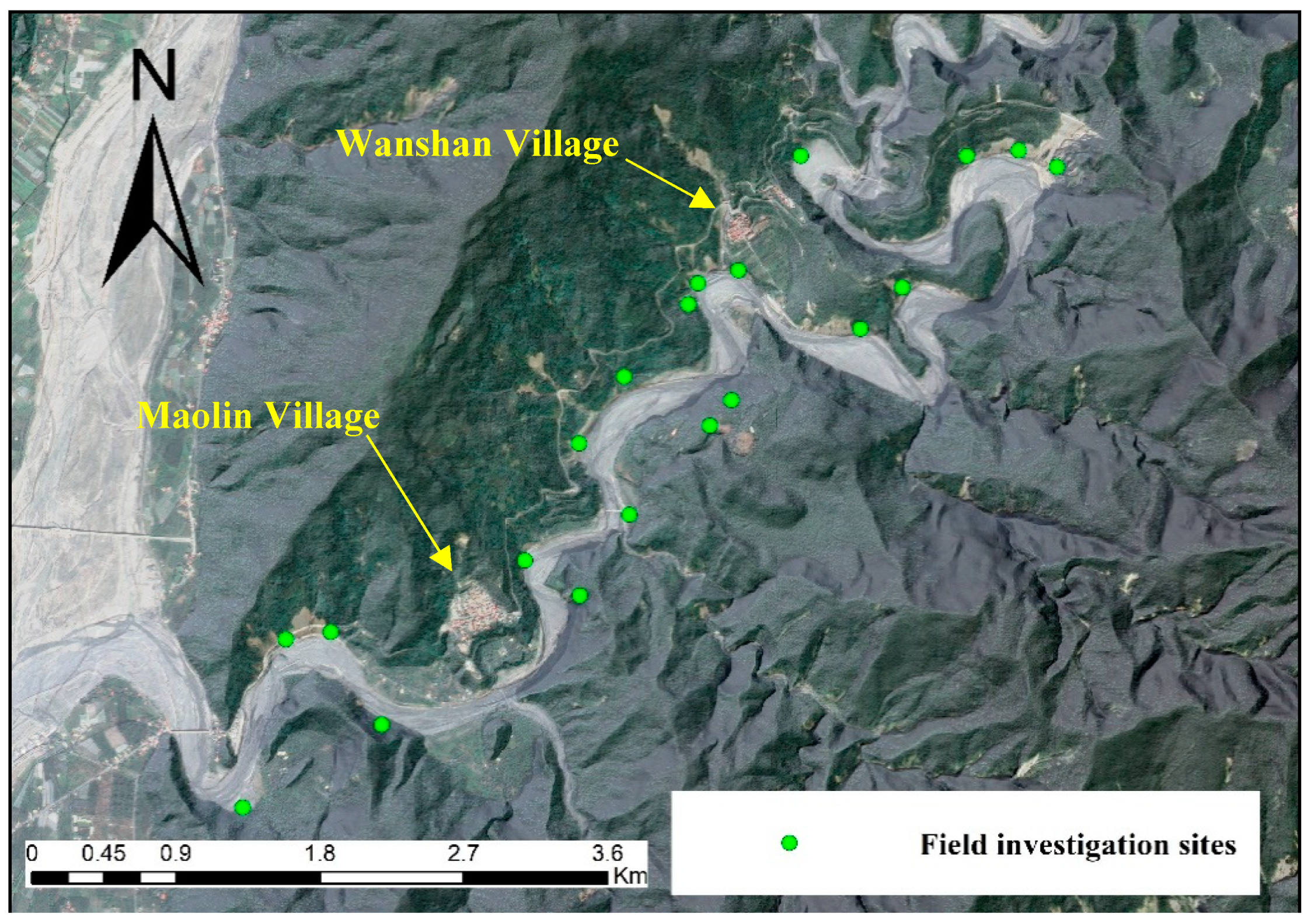
The results from the LSI analysis and the landslide inventory results allowed for the identification of locations susceptible to landslides in Maolin Village, Wanshan Village, and Dona Village. Our field investigation also verified the location of and processes involved with the slope failures near the communities. Importantly, using an LSI map to identify areas prone to landslide activity is not valuable to untrained users, such as the local residents. Such a technical map has little information value to residents that have limited knowledge of the geologic units, statistics, mathematics, and computer software involved. Therefore, this study presents a simplified landslide zone map.
The landslide zone map was generated (
Figure 11) by using a FS-2 base image of the three villages. The LSI results, landslide inventory results, and field work findings were overlaid, and polygons were created to identify terrain conditions where landslides are likely to occur, using an expert approach to identify verifiable landslide zones. Two zones were identified: a general “landslide zone” (green) and “landslide zone (meander)” (yellow). Zonal boundaries were highlighted with a simple outline to ensure ease of use and understanding.
Four emergency shelters (safe zones), at least one within each village, were included on the map. The goal was to produce a map for residents, stakeholders, and visitors that is clear, simple, and without the clutter and jargon of a technical hazard map. With this in mind, this map can help establish a safety standard as an additional aspect of community development and resilience.
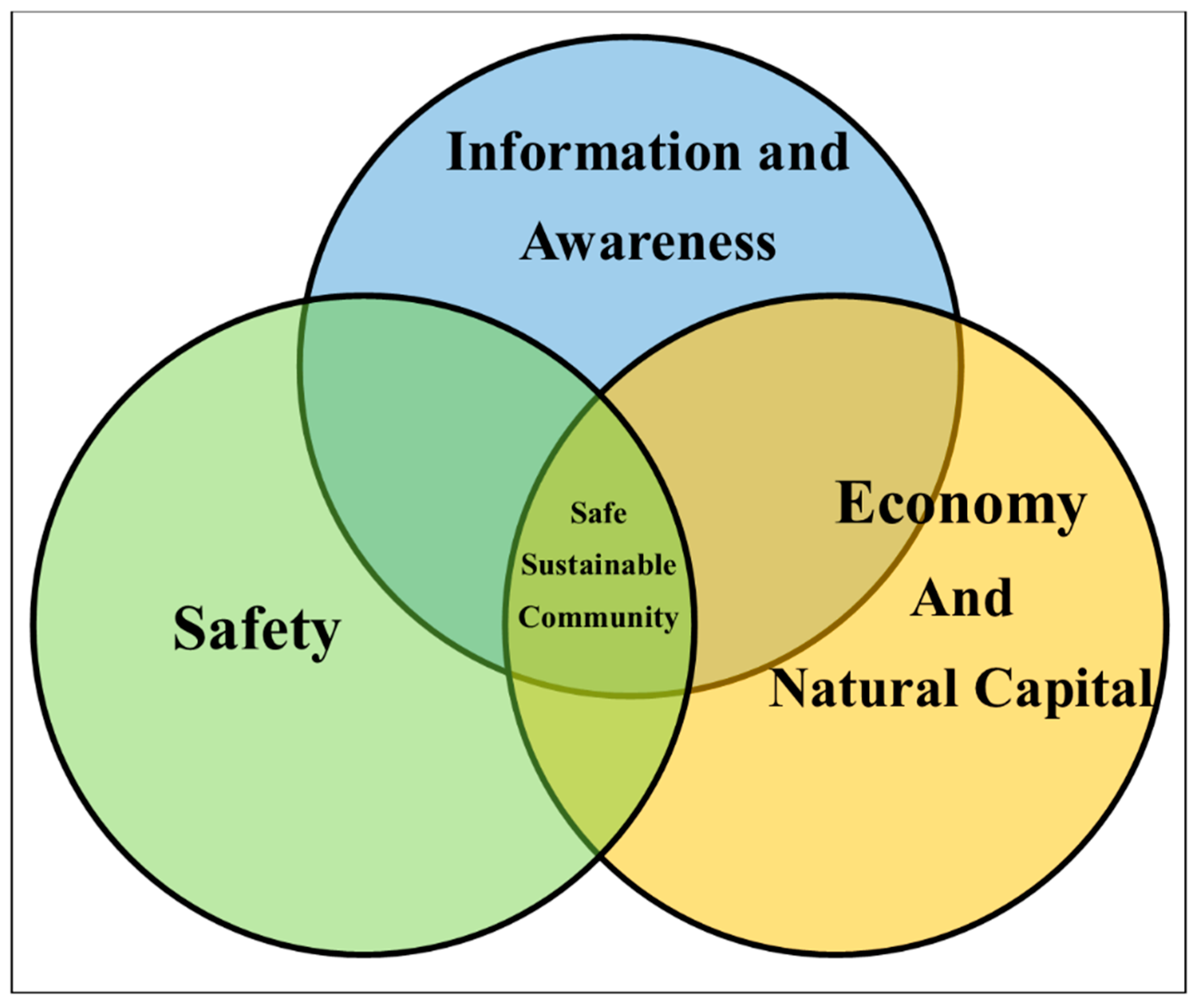
3.4. Sustainability Framework
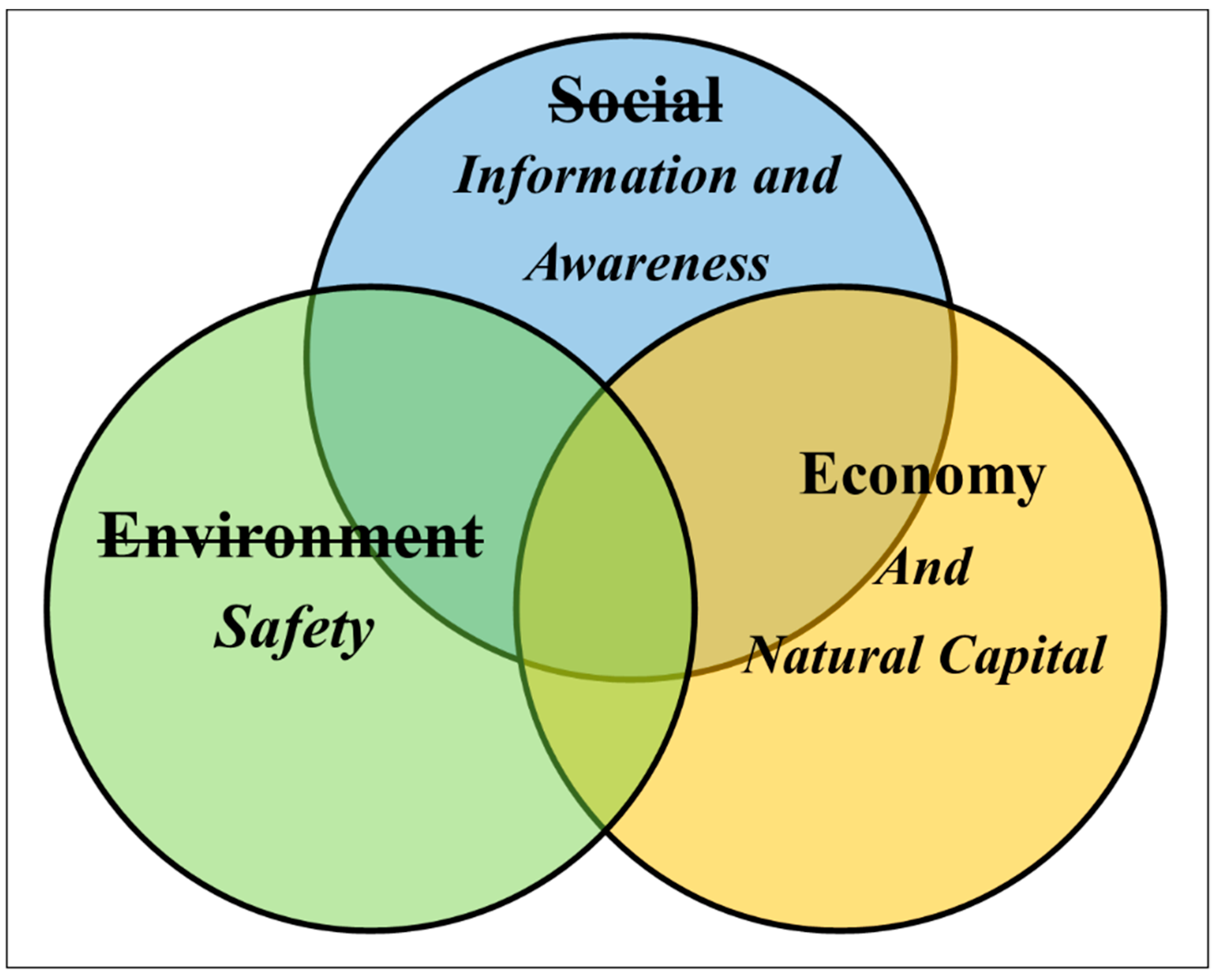
To integrate these diverse data streams and to improve our understanding of the natural and human phenomena associated with communities facing geohazards, we proposed here a framework for analyzing sustainability. Within this framework, three core criteria were identified, which should be considered with respect to the communities in Maolin District. This framework can serve as a tool for stakeholders to improve their community’s resilience to future landslides.
This sustainability framework combines these three core criteria (
Figure 12) to achieve a safe and sustainable community. There is a significance behind the linkage of the criteria. Each criterion is dependent on the other to successfully attain community sustainability. If one or more is not met, the community may face increased vulnerability and lower resilience to landslide activity. This framework requires data streams to be integrated from scientific and social science fields to fully develop a multidisciplinary management plan.
3.5. Discussion
The questionnaire results show that there is a need to further develop the flow of information available to the local residents of Maolin District. The vague responses observed during the questionnaire analysis further support the need for an improved and reliable source of geohazard information. This study also revealed that the residents demonstrated a lack of faith in non-local nongovernmental organizations and government departments alike. Thus, information should be made available within the established outlets of the community, such as the church or community halls. Simplified, easy to understand pamphlets should be distributed to the local residents that contain information on evacuation routes, emergency shelters, and hazard zones. The promotion of internet use as a source of local information should also be a point of discussion in this community. Similarly, based on the questionnaire findings, reliable sources of information were shown to be scarce. Tribal leaders or trusted individuals should be given responsibility for communicating accurate information to community members. Streamlining the chain of command could efficiently allow for improved information flow in the community.
To achieve sustainability, the local economy must also be developed to be more resilient [
34]. A community must be able to prepare for, withstand, and recover from the impacts of a landslide. Working within the community was identified as an important factor for the survival of this community. Even when faced with the threat of geohazards, the anecdotal information reveals that the residents described this area as their “home” and that they preferred to remain in the community. However, the economic conditions within the villages revealed an ecotourism industry in its infancy, lacking vision, support, and direction from the community. The potential benefits (positive effects) versus the costs (negative effects) must be considered carefully by the community prior to implementing new development initiatives [
35]. Environmental protection was viewed as a priority by the residents; however, from the perspective of the residents, the government needs to spend more money on road development and environmental and cultural preservation programs. Therefore, it is clear that development strategies are required for the short, middle, and long term [
36]. Moreover, there is a need for a value-added approach to tourism development in Maolin. Such initiatives can follow the success of small-scale coffee growers [
37]. Furthermore, there is much room for improvement; visitors stay for a short period of time in the study area. Anecdotal reports from the residents indicate that they perceive that visitors feel that there are limited activities in Maolin.
Furthermore, anecdotal evidence reveals that there are several locations suitable for the extraction and development of hot springs; however, based on the local residents’ opinion, the government does not want to support drilling for this resource. Careful consideration is required to ensure that this area’s infrastructure can carry the capacity of the influx of tourists expected as the reconstruction work nears completion. Future plans must use the natural capital within this area conservatively. This should include the development of trail networks for biking, walking, and hiking. The relative remoteness of the villages from major urban centers leaves the villages lacking access to local shopping and procurement of supplies on a daily basis. There is a need for further development of community-based distribution centers that would allow for goods to be purchased by locals for locals. Similarly, there is further need for the enrichment of the cultural activities and products available for tourists to experience and purchase. This should include bilingual information for international visitors, as well as the further diversification of the quantity of locally made crafts.
4. Conclusions
This study evaluated of the sustainability of a mountain community in Southern Taiwan. The use of an LSI map, landslide inventory datasets, and field work analysis were used to identify areas susceptible to landslides. The results of this study show that an LSI map is an effective tool for identifying landslide zones. Multi-temporal landslide inventory analysis and expert field investigation further improved the process of identifying landslide activity in highly susceptible landslide zones. A community-based participation questionnaire was also distributed to the local residents to evaluate their awareness of landslides and sustainability.
The questionnaire results indicate that the residents had moderate awareness of and access to information related to landslides. Similarly, the residents were in favor of increased environmental protection, working within their community, and increased government spending to improve their community’s preparedness for natural disasters. In this study, we proposed a sustainability framework that is based on the integration of three core criteria: safety, information and awareness, and economy and natural capital. This framework presents guidance that is useful for land use management and the development of safe, resilient, and sustainable communities.
Furthermore, the fluvial feature of meander was identified as an important factor influencing the distribution of slope failures in the study area. Similarly, the complex geologic conditions of the study area significantly contributed to the reoccurrence of mass movements, especially debris flows and debris avalanches.


