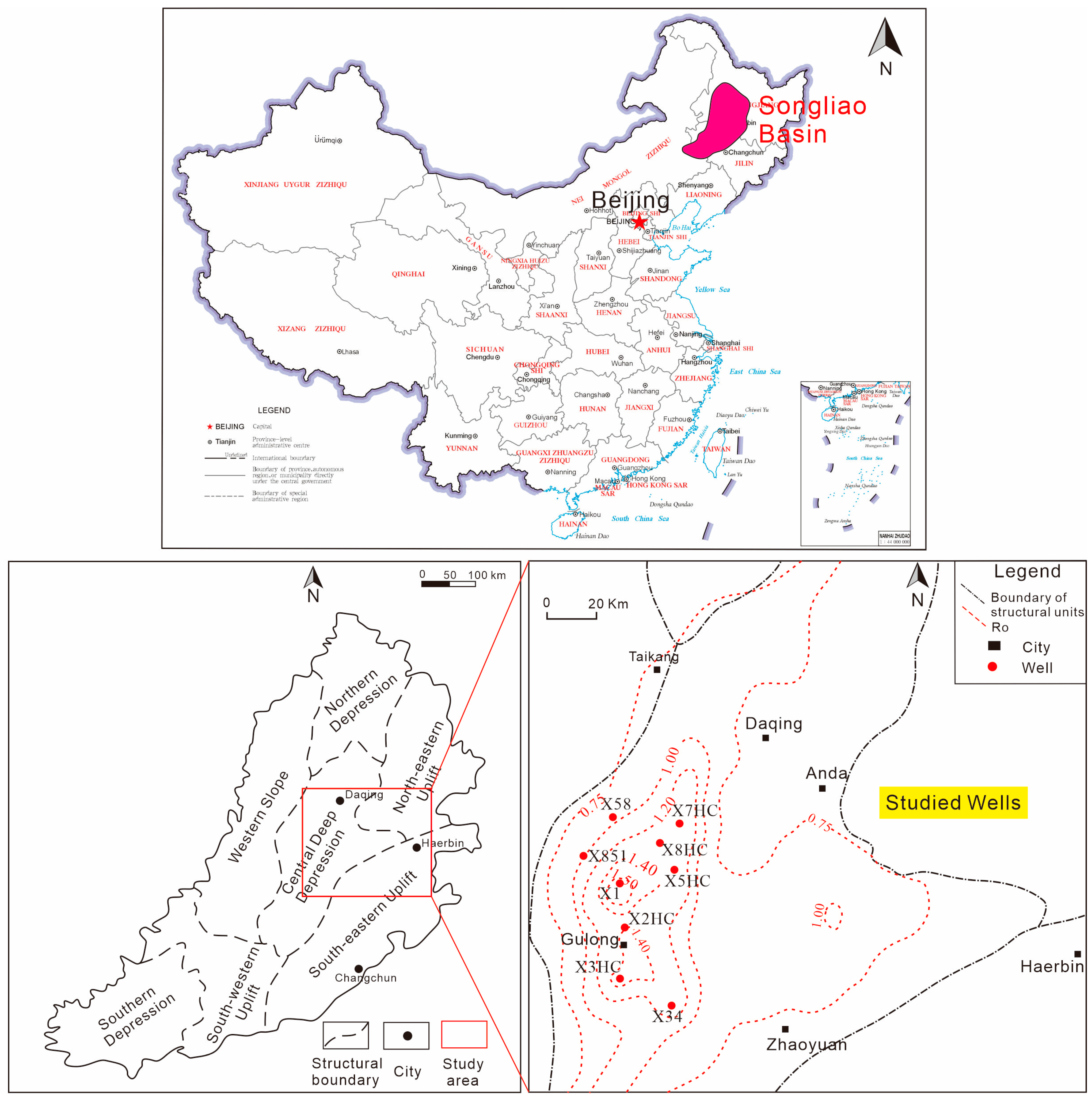
Figure 1.
Structural zoning and location of the study area [
15].
Figure 1.
Structural zoning and location of the study area [
15].
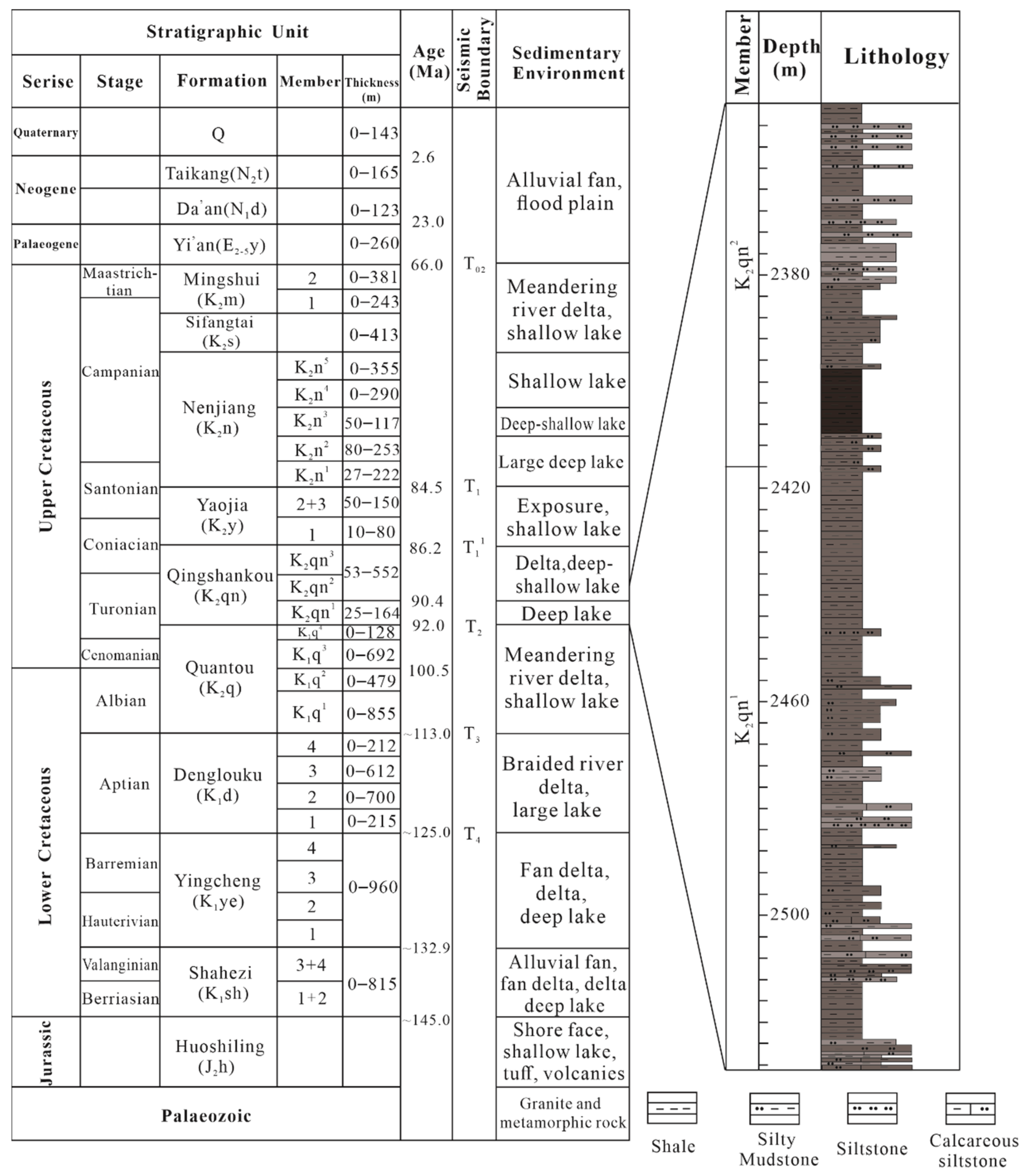
Figure 2.
Stratigraphy of the study area [
15].
Figure 2.
Stratigraphy of the study area [
15].
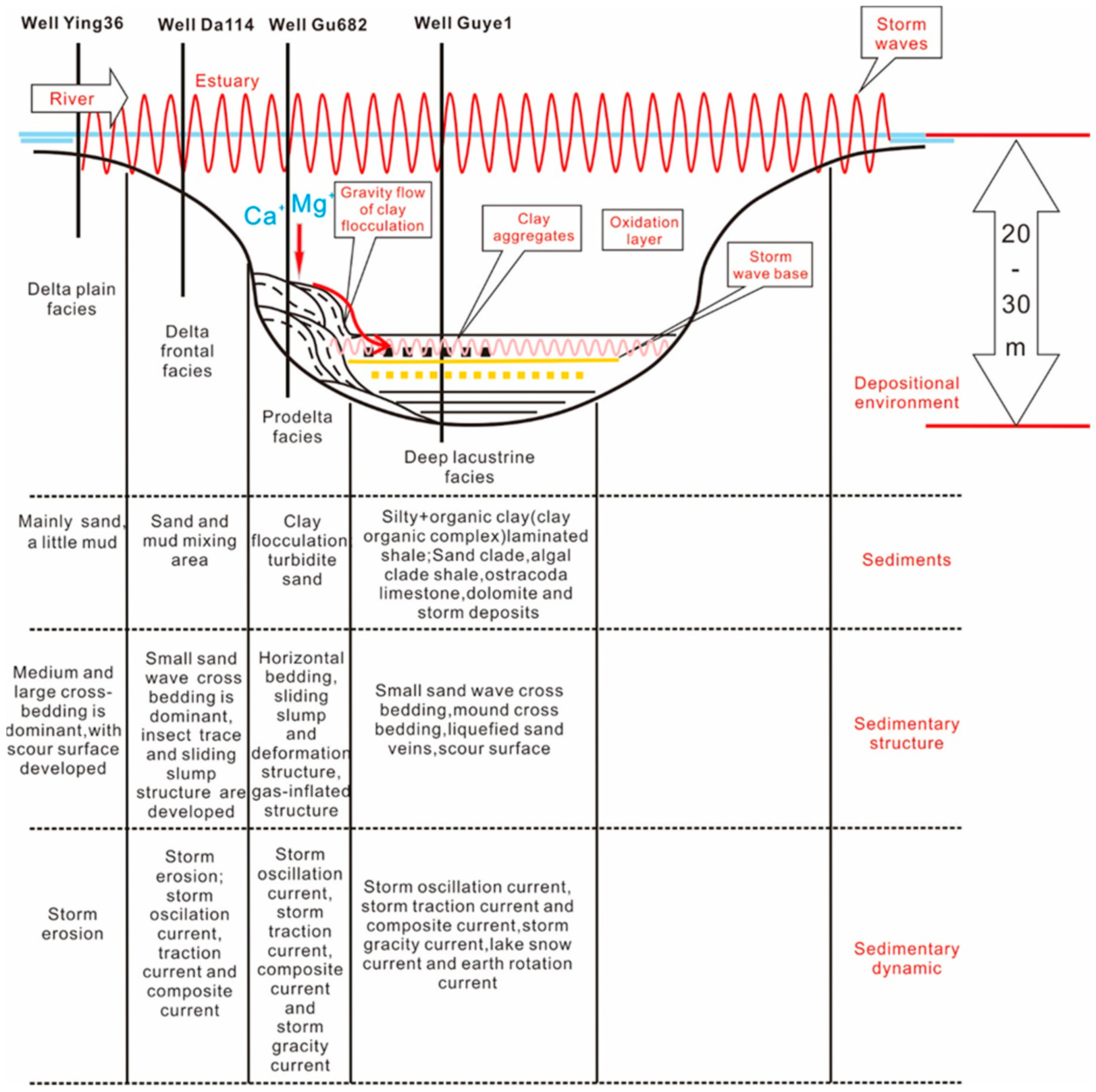
Figure 3.
Model of salt lake storm deposition in the Qingshankou Formation, Gulong Sag (after [
30]).
Figure 3.
Model of salt lake storm deposition in the Qingshankou Formation, Gulong Sag (after [
30]).
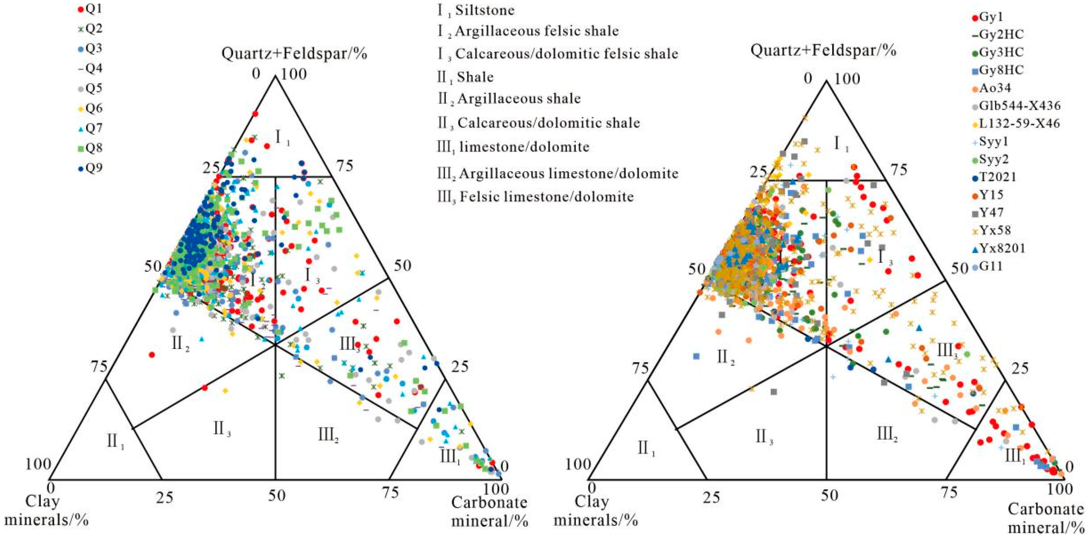
Figure 4.
Triangulation of the mineral content of the shale oil reservoir in the Qingshankou Formation, Gulong Sag.
Figure 4.
Triangulation of the mineral content of the shale oil reservoir in the Qingshankou Formation, Gulong Sag.
Figure 5.
Macro-petrographic characteristics of dolomite thin layers and nodules. ((A). Gray-brown dolomite. A dissolution pore seam developed in the middle right and filled with oil (marked by a large red arrow), the height of the label is 2 cm. (B). Grayish-yellow dolomite. Development of fine dissolution pores filled with oil (marked by red arrows). (C). Grayish-yellow dolomite. Development of a fine (small red arrow) and larger dissolution hole (large red arrow) filled with oil, the height of the label is 2 cm. (D). Gray-black dolomite. Developed shear fractures: (E). Dolomite nodules in the form of eyeball turns (red dashed line and yellow line), the height of the label is 2 cm. (F). Numerous liquefied silt veins (red arrows) developed in dolomite nodules (blue arrows). (G). Gray-brown clouded shale developed from the lower phyllite. (H). Yellow-brown clouded shale with phyllite development).
Figure 6.
Considerable amounts of sand-grade mud debris in argillaceous dolomite. ((A). Oil-bearing dolomite, in which numerous silt veins were developed. (B). Magnification (30×) of the red box in Figure (A) showing dolomite (white arrow) and mud flakes (black arrow). (C). Fractured calcite developed in dolomite. (D). Large number of sand-grade mud flakes (red arrows) and dolomite cementation (white arrows) are visible at 30× magnification in the yellow box in Figure (C)).
Figure 7.
Microscopic characteristics of dolomite ((A) very pure dolomite, with a mineral composition of 95% dolomite, 1% pyrite, and 4% quartz; (B) enlargement of the yellow box in Figure (A), clearly showing quartz (blue arrows) and asphalt (red arrows); (C) purer dolomite with ostracodas and other minerals; (D) purer dolomite with felsic minerals; (E) impure dolomite with a great deal of felsic minerals, asphalt, and ostracodas; (F) impure dolomite with a great deal of felsic minerals, asphalt, and ostracodas).
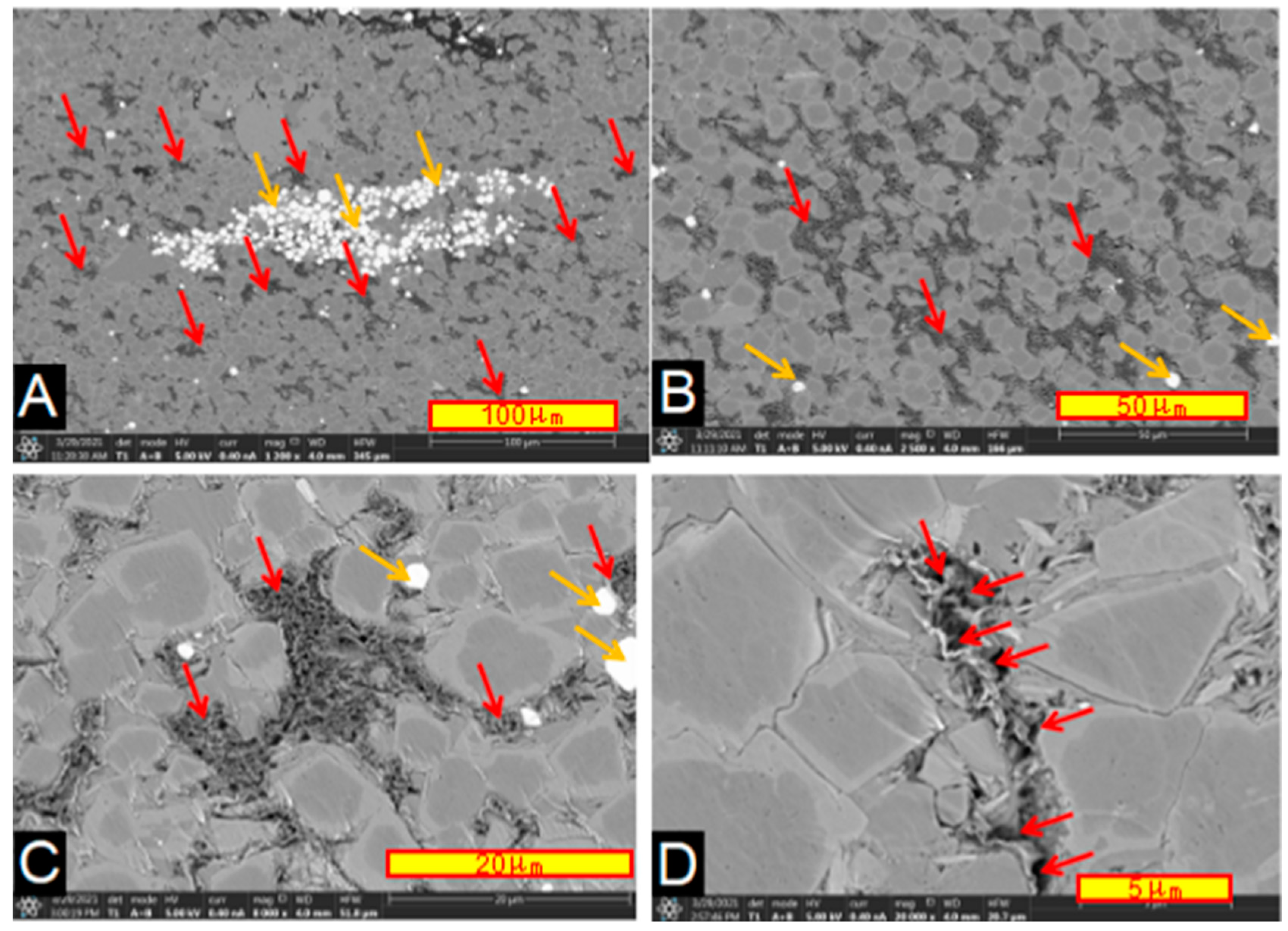
Figure 8.
Backscattering pattern of dolomite and its intercrystalline nanopores. ((A). Dolomite, pyrite, and green montmorillonite mixed clay; dolomite intergranular pores developed (red arrows); pyrite was produced in aggregates (orange arrows). (B). Illite and chlorite (red arrows) between dolomites; Intergranular pores (red arrows) developed. (C). Dolomite and green monzonite clay (red arrows). Green monzonite clay is sponge-like, in which a large number of nano-pores are developed, which indicates a good storage space, there are some pyrite (orange arrows). (D). Dolomite and green montmorillonite mixed-layer clay (red arrow)).
Figure 9.
Oil-bearing dolomites. ((A). An oil-saturated dolomite nodule, the height of the label is 2 cm. (B). Micrograph of Figure (A) showing that it is mainly a fine-grained dolomite with a microshear strip (red arrows) in the middle containing felsic minerals and there are bitumen strips and bitumen clumps. (C). Oil-bearing dolostone nodule, the height of the label is 2 cm. (D). Micrograph of Figure (C) showing that it is mainly a fine-grained dolomite containing felsic minerals at the right bottom, as well as bitumen strips (red arrows) and bitumen clumps. (E). Micrograph of Figure (C) showing that it is mainly a fine-grained dolomite (red arrows) containing felsic minerals (yellow arrows) at the upper right corner, which appears to be a suture line. (F). Micrograph of Figure (C) showing a significant amount of bitumen (red arrows) and felsic minerals (yellow arrows). (G). Uniform fine-grained dolomite with intergranular pores filled with bitumen. (H). Enlarged view of the red box in Figure (G) showing that the intergranular pores are filled with bitumen (red arrows), and they are scattered among the dolomites (black arrows)).
![Energies 16 03981 g009]()
Figure 10.
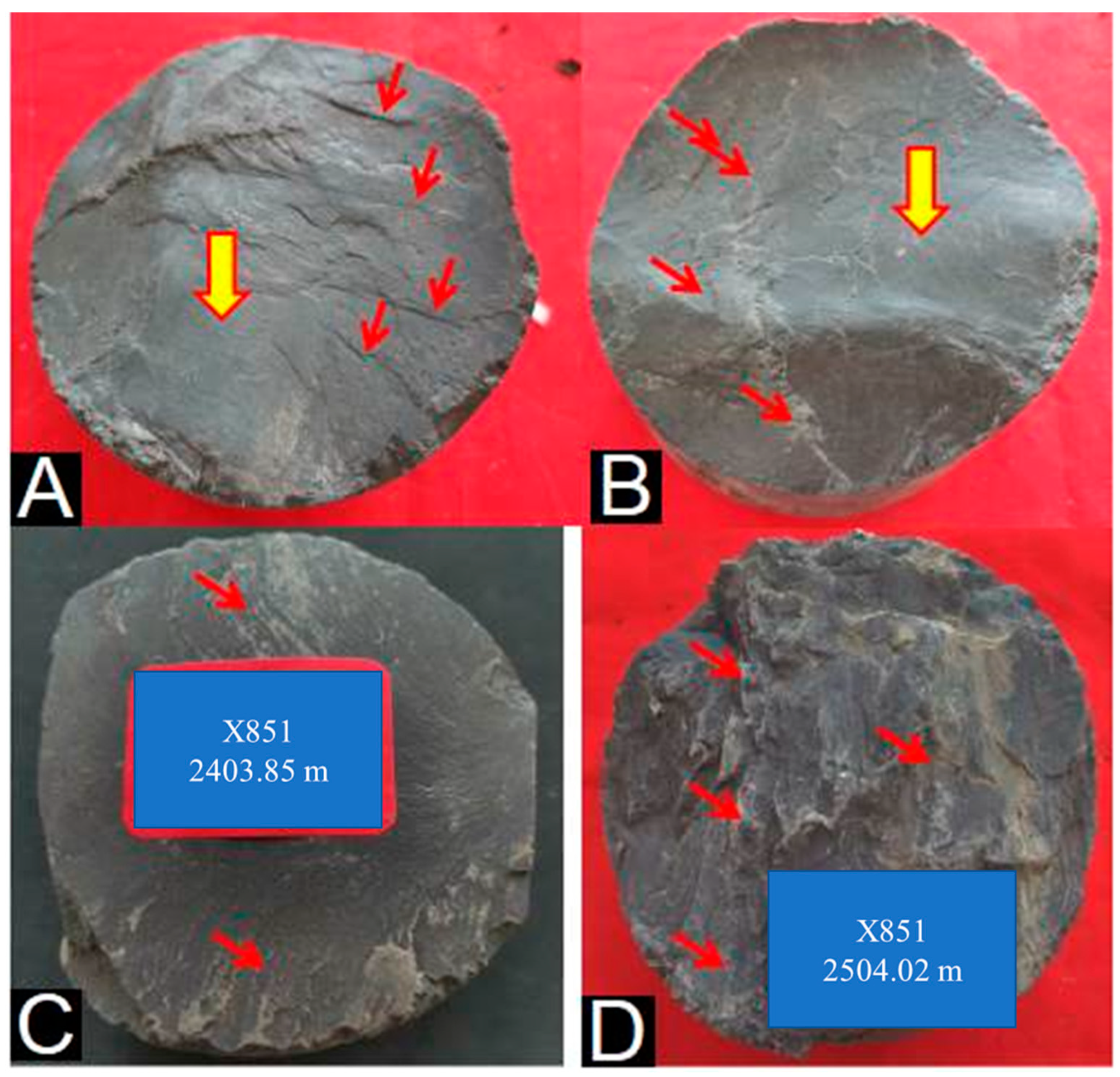
Friction surface and step on the top surface of dolomite. ((A). Frictional light surface (large yellow arrow) and steps (red arrow) of the dolomite top surface. (B). Frictional light surface (large yellow arrow) and step (red arrow) of the dolomite top surface. A frictional luminous surface in the form of waves and the direction of the step, with waves in the form of a step. (C). Flattened shear surfaces on which steps developed (red arrows), the height of the label is 2 cm. (D). Dense cracks (red arrows) on the top surface of dolomite, the height of the label is 2 cm).
Figure 10.
Friction surface and step on the top surface of dolomite. ((A). Frictional light surface (large yellow arrow) and steps (red arrow) of the dolomite top surface. (B). Frictional light surface (large yellow arrow) and step (red arrow) of the dolomite top surface. A frictional luminous surface in the form of waves and the direction of the step, with waves in the form of a step. (C). Flattened shear surfaces on which steps developed (red arrows), the height of the label is 2 cm. (D). Dense cracks (red arrows) on the top surface of dolomite, the height of the label is 2 cm).
Figure 11.
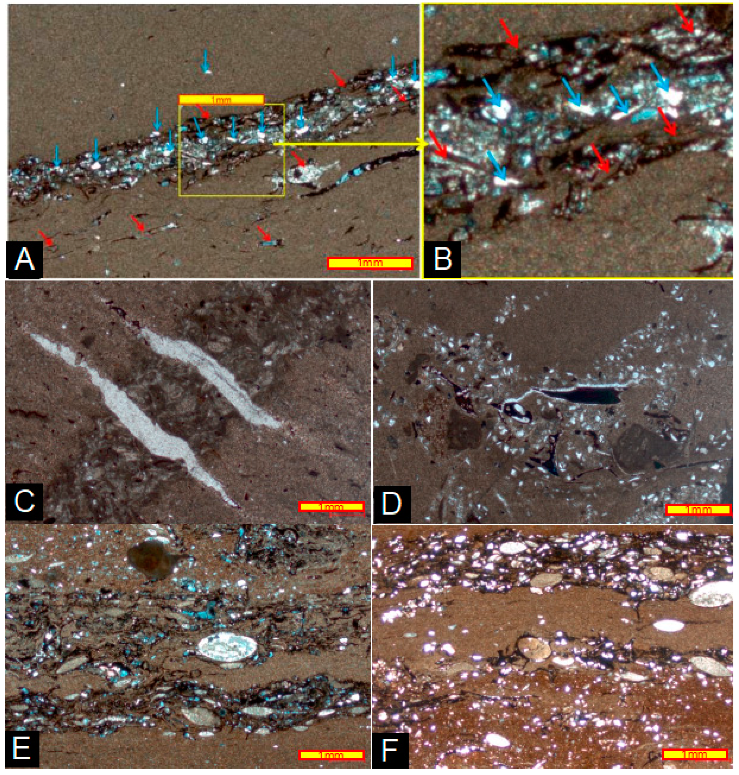
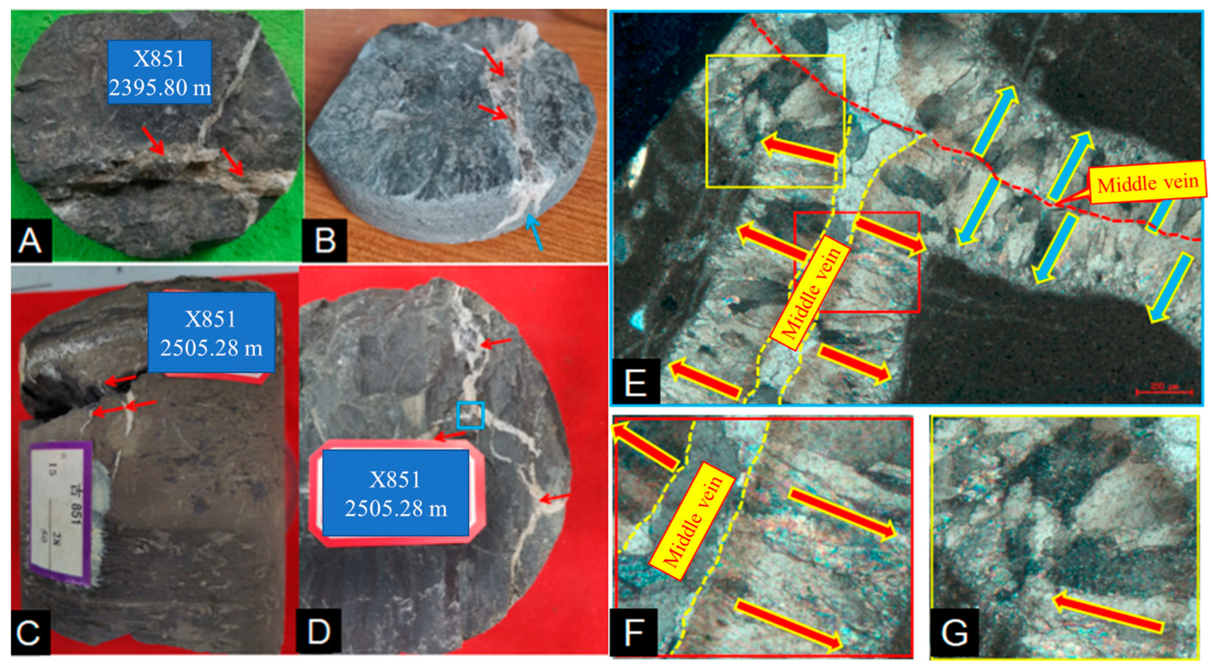
Calcite veins in dolomite. ((A). Calcite veins in dolomite, irregular; calcite veins yellowish-brown with oil (red arrows); tensor vein, the height of the label is 2 cm. (B). Three-dimensional view of panel (A). Calcite veins bifurcating acutely downward (blue arrows); calcite veins yellowish brown and contain oil (red arrows). (C). Calcite veins (red arrows) in dolomite, irregular, downward-pointed extinction, tensor veins, the height of the label is 2 cm. (D). Calcite veins (red arrows) in dolomite and irregular and strongly divergent tensor veins, the height of the label is 2 cm. (E). Magnification of the blue box in Figure (D) showing the calcite veins growing direction (red and blue arrows) along a thinner midvein, nearly symmetrical on both sides. (F). Magnification of the red box in Figure (E) showing that calcite veins are composed of finer calcite crystals. The red arrow indicates the direction of calcite crystal growth. (G). Magnification of the yellow box in Figure (E) showing that calcite veins are also composed of finer calcite crystals (red arrow).).
Figure 11.
Calcite veins in dolomite. ((A). Calcite veins in dolomite, irregular; calcite veins yellowish-brown with oil (red arrows); tensor vein, the height of the label is 2 cm. (B). Three-dimensional view of panel (A). Calcite veins bifurcating acutely downward (blue arrows); calcite veins yellowish brown and contain oil (red arrows). (C). Calcite veins (red arrows) in dolomite, irregular, downward-pointed extinction, tensor veins, the height of the label is 2 cm. (D). Calcite veins (red arrows) in dolomite and irregular and strongly divergent tensor veins, the height of the label is 2 cm. (E). Magnification of the blue box in Figure (D) showing the calcite veins growing direction (red and blue arrows) along a thinner midvein, nearly symmetrical on both sides. (F). Magnification of the red box in Figure (E) showing that calcite veins are composed of finer calcite crystals. The red arrow indicates the direction of calcite crystal growth. (G). Magnification of the yellow box in Figure (E) showing that calcite veins are also composed of finer calcite crystals (red arrow).).
![Energies 16 03981 g011]()
Figure 12.
Argillaceous dolomite and its microscopic characteristics. ((A). Argillaceous dolomite nodules developed with fractures and calcite veins. (B). Enlarged view of the red box in Figure (A). It is formed by a large amount of gray-black silty silt and dolomite cement. (C). Another dolostone concretion. (D). Enlarged view of the yellow box in Figure (C). Large quantities of silty silt and dolomite cement between the silt are also observed. (E). Enlarged view of the red box in Figure (D). Large quantities of silty mud particle (red arrows) and dolomite cement between mud particles are also observed. (F). Enlarged view of the yellow box in Figure (D). Large quantities of silty mud particles (red arrows) and dolomite cement between mud particles are also observed).
Figure 13.
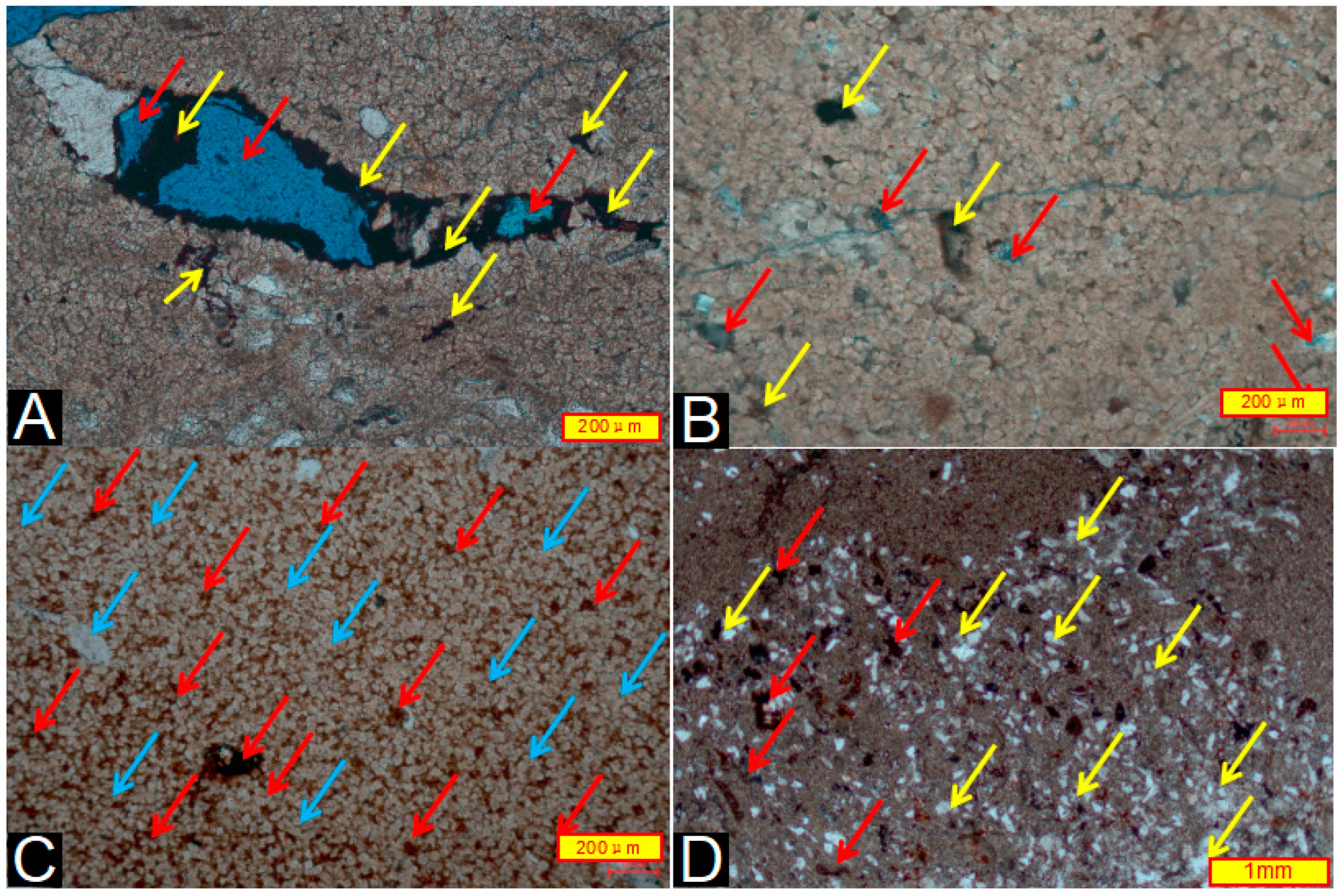
Reservoir space of clay-bearing dolomite. ((A). Dissolved pores (red arrows) partially filled with bitumen (yellow arrows). (B). Large number of weak dissolution pores developed between dolomite grains, which are filled with casting gel (red arrows) and bitumen (yellow arrows). (C). Great number of pores filled with bitumen (red arrows) between dolomite grains (blue arrows). (D). A significant number of felsic particles (yellow arrows) mixed locally and bitumen (red arrows) that occupy the dissolved pores).
Figure 13.
Reservoir space of clay-bearing dolomite. ((A). Dissolved pores (red arrows) partially filled with bitumen (yellow arrows). (B). Large number of weak dissolution pores developed between dolomite grains, which are filled with casting gel (red arrows) and bitumen (yellow arrows). (C). Great number of pores filled with bitumen (red arrows) between dolomite grains (blue arrows). (D). A significant number of felsic particles (yellow arrows) mixed locally and bitumen (red arrows) that occupy the dissolved pores).
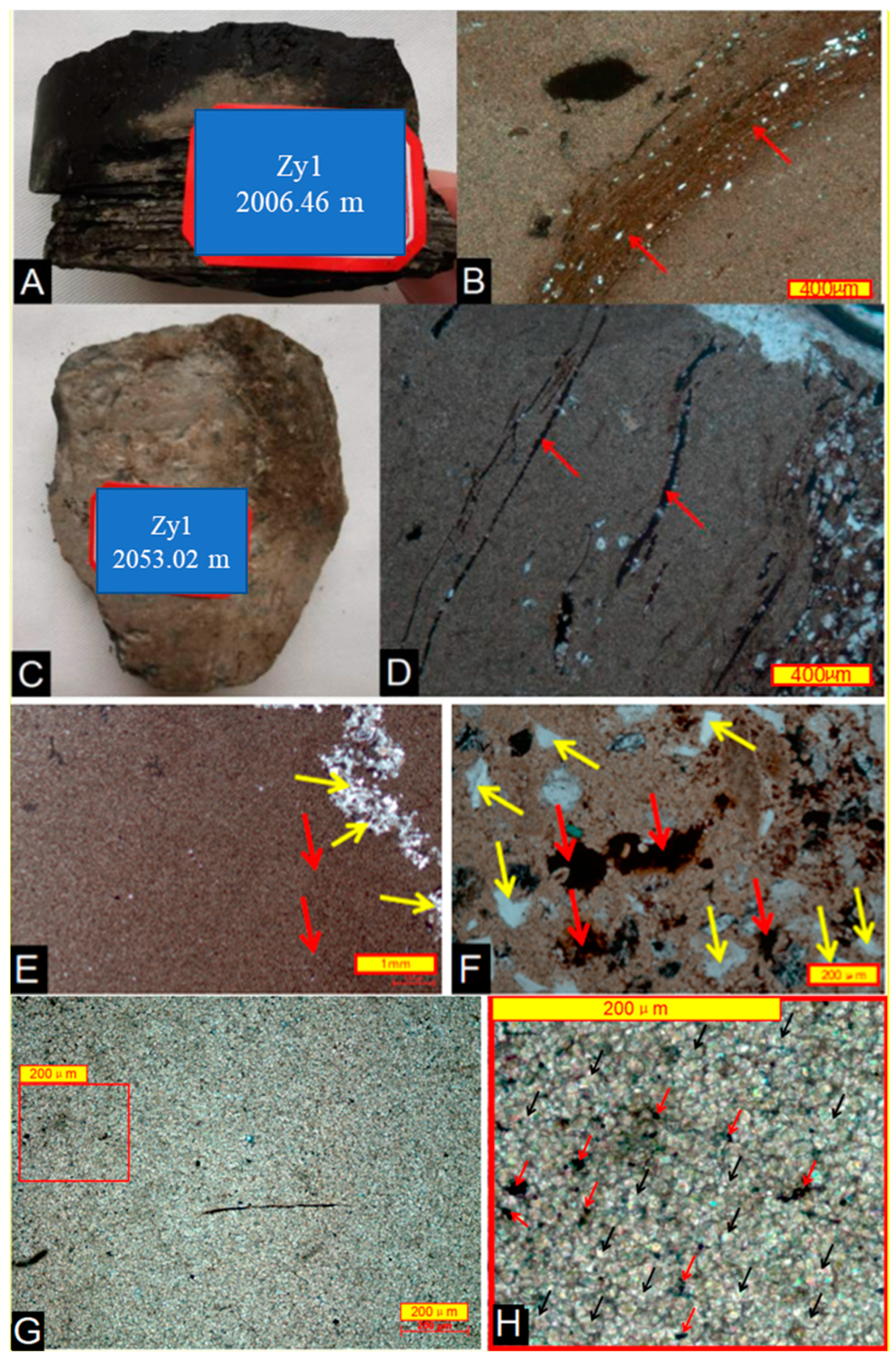
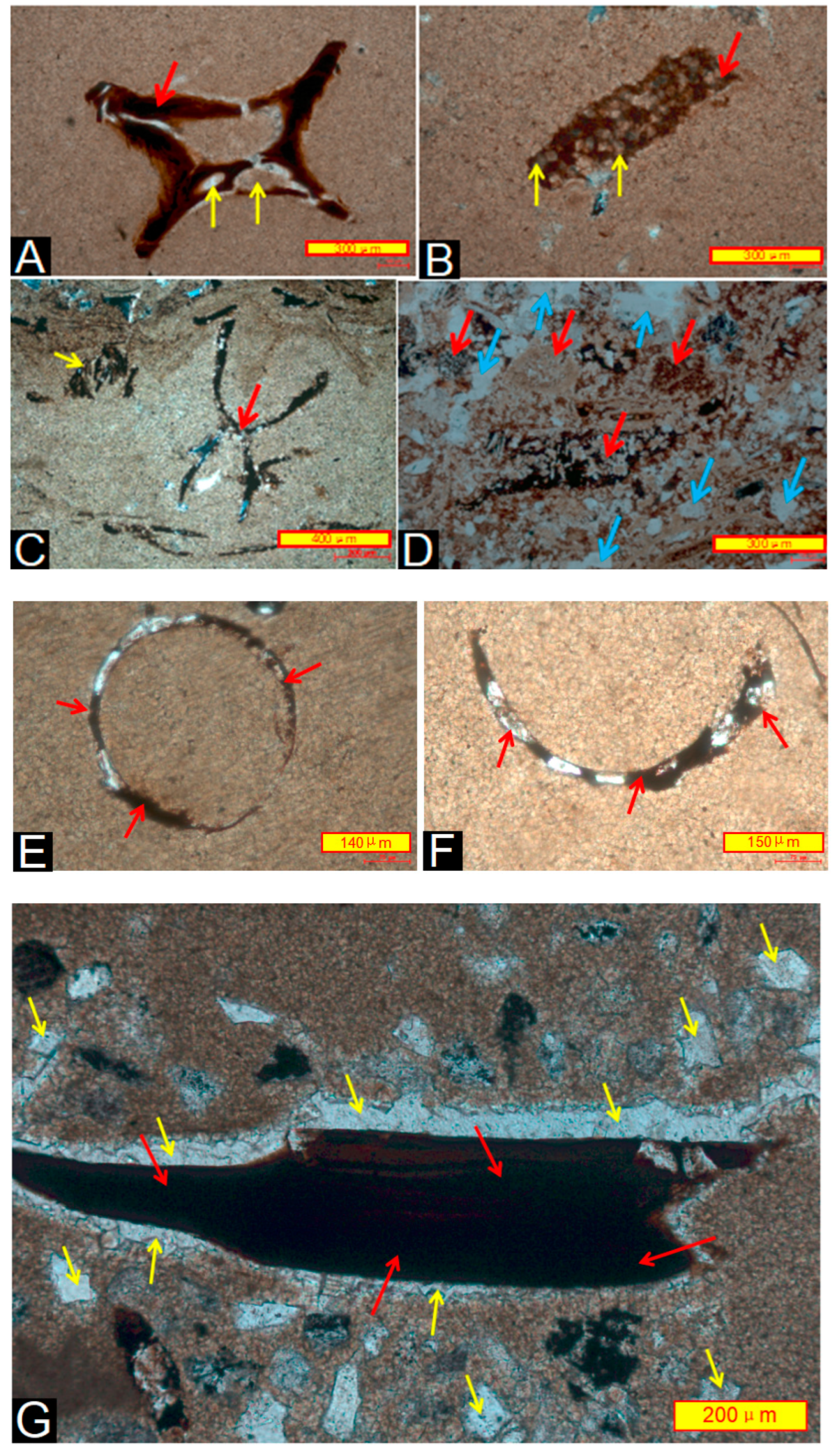
Figure 14.
Suspected carbonized biofossils in dolomite. ((A,B). Organisms with cellular structure (red arrows) containing two well-preserved cellular lumens (yellow arrows). (C). Double-aeolian organic matter (red arrows) with a large amount of residual cellular cavities (yellow arrows). The black color is due to intense carbonation. (D). Organic matter with cellular structure (red arrows), and a large number of long particles (blue arrows). (E). Circled carbonized plant residue (red arrows), produced in pure dolomite. (F). Semicircular rings of carbonized plant residues suspected (red arrows) to be produced in pure dolomite. (G). Large carbonized plant remnant (red arrow) with strong dolomitization on the outer rim and transformation from mud crystal calcite to larger dolomite crystals (yellow arrow)).
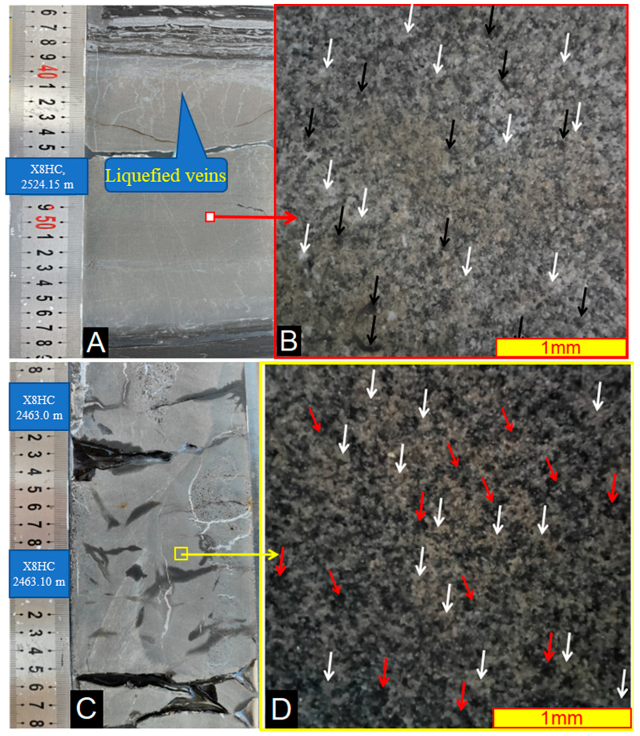
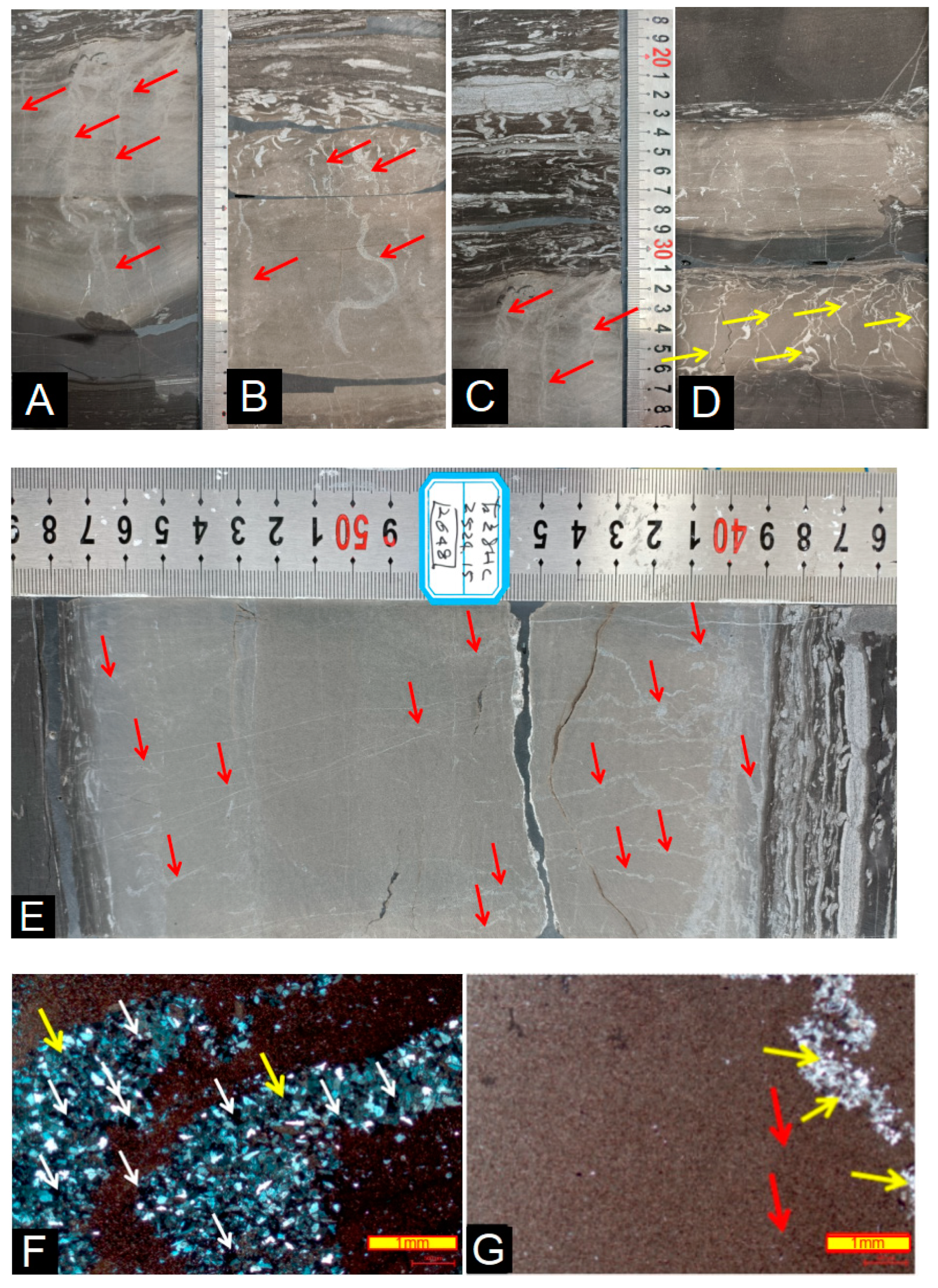
Figure 15.
Silt and calcite veins in thin layers of clay-bearing dolomite and nodules. ((
A). Development of slightly curved silt veins (red arrows) in the dolomite reveals that consolidation of the dolomite occurred early in diagenesis and that little compaction occurred during later diagenesis. (
B). Complex silt veins (red arrows) developed in the dolomite; the upper veins are small in size but complex, and one silt vein in the middle is more bent and “S”-shaped, although the bending rate is smaller than that of the silt veins in the clay. (
C). Complex silt veins (red arrows) developed in the dolomite, and they are complex in the upper part, simple in the middle and lower parts, and linear. This indicates the absence of compaction shortening in the vertical direction. (
D). Complex silt veins (yellow arrows), with the lower ones calcified. The silt veins in the upper dolomite layer were flatter and straighter, indicating that they were not bent by compaction. (
E). Large number of penetrating silt veins (red arrows) developed in the thicker dolomite, and the top was denser and more complex. The middle and lower parts were simpler and had less curvature, indicating less compaction. (
F). Micrograph of a silt vein in dolomite, coarser and curved; a large number of mud flakes (white and yellow arrows) are visible, revealing that the silt vein passed through the mud into dolomite. Orthogonal polarization is observed. (
G). Micrograph of a silt vein (yellow arrow) in dolomite, more slender and curved, like intestines. There are great deals of bitumen (red arrows) between dolomite. This is the same photo as
Figure 9E. Orthogonal polarization is observed).
![Energies 16 03981 g015]()
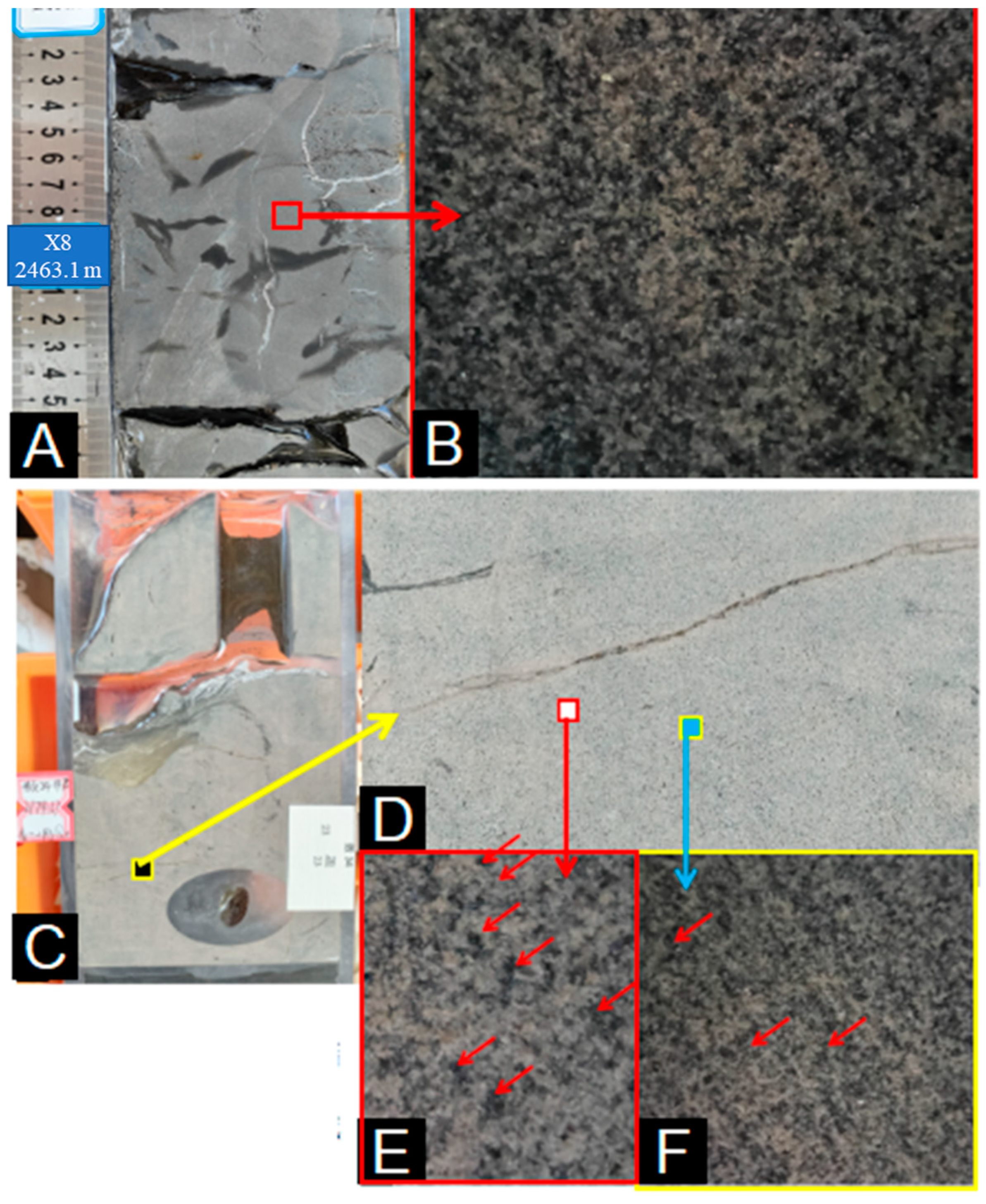
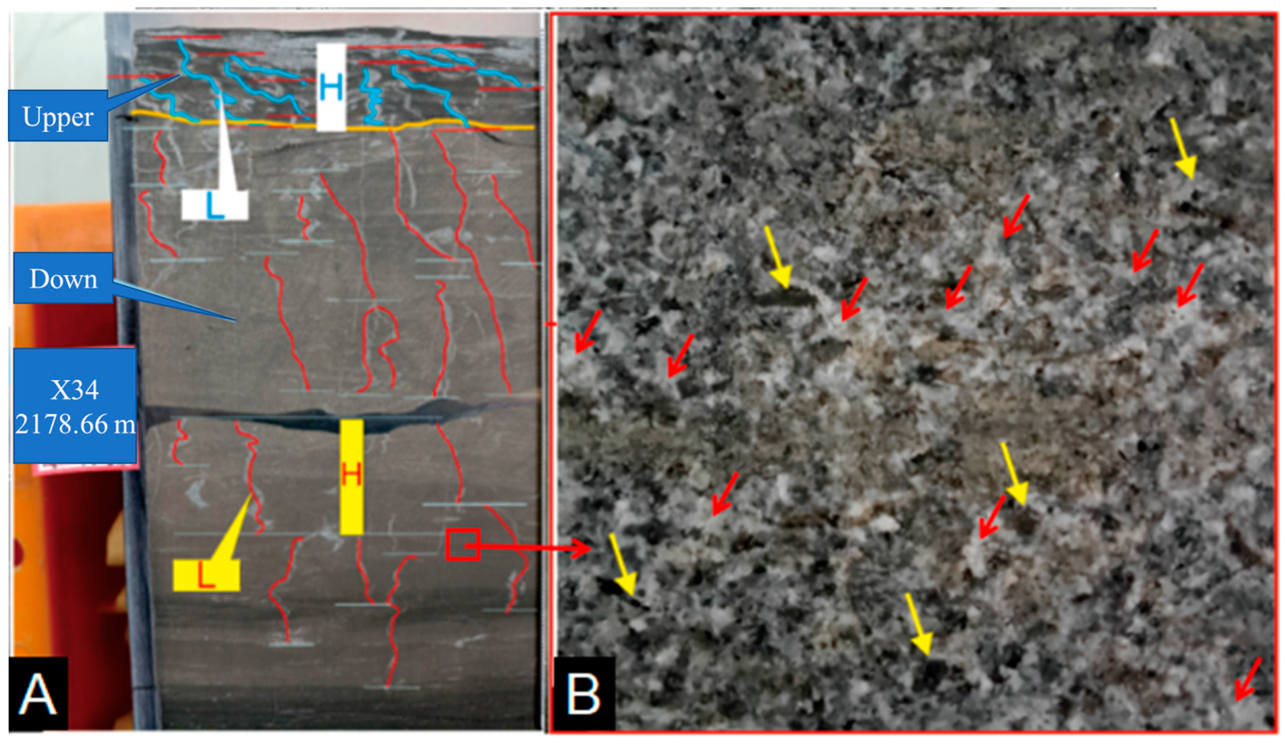
Figure 16.
Silt veins in argillaceous dolomite. ((
A). Silt veins in oil-bearing dolomite (red arrows) and in gray-black mud shale (blue arrows). Slightly curved silt veins in dolomite with a compaction ratio of 1.48 (
Table 2) indicate trace compaction but no lateral shear. The silt veins in the top mud shale are clearly curved and inclined, with a compression rate of 2.68 (
Table 3), H is the thickness of the rock, and L is the length of the sand veins. (
B). Dolomite (nodules) with a large amount of grayish-brown chalk-grade mud flakes (yellow arrows) that account for approximately 40–50%, with dolomite between the mud flake particles; therefore, dolomite occurs as cement (red arrows), while dolomite (nodules) is just a layer of cloudy mudstone or muddy cloudstone.).
Table 1.
Mineralogical compositions in dolomite thin layers and nodules.
Table 1.
Mineralogical compositions in dolomite thin layers and nodules.
| Sample | Depth (m) | Sag | Layer | Lithology | Quartz | Potash Feldspar | Plagioclase Feldspar | Calcite | Ankerite | Clay Mineral | Pyrite | Siderite |
|---|
| A1-4 | 2484.5 | Gulong | K2qn2 | Dolomite | 1.1 | 0 | 1.7 | 0 | 94.9 | 2.3 | 0 | 0 |
| A1-5 | 2486.2 | Gulong | K2qn2 | Dolomite | 3.2 | 0 | 1.7 | 0 | 92 | 3.2 | 0 | 0 |
| A1-7 | 2490.5 | Gulong | K2qn2 | Dolomite | 3.2 | 0 | 2.5 | 0 | 91.2 | 3 | 0 | 0 |
| A1-11 | 2545.8 | Gulong | K2qn1 | Dolomite | 0.7 | 0 | 1.3 | 0.2 | 96.6 | 1.2 | 0 | 0 |
| A1-14 | 2562.6 | Gulong | K2qn1 | Dolomite | 2.8 | 0 | 1.3 | 0 | 92.4 | 2.5 | 1 | 0 |
| A3-160 | 2179.8 | Gulong | K2qn2 | Clay-bearing Dolomite | 14.4 | 0 | 3 | 0 | 78.8 | 3.8 | 0 | 0 |
| A3-171 | 2189.7 | Gulong | K2qn2 | Clay-bearing Dolomite | 9.4 | 0 | 1.8 | 0 | 82.4 | 6.4 | 0 | 0 |
| A1-3 | 2471.5 | Gulong | K2qn2 | Clay-bearing Dolomite | 4.1 | 0 | 4.4 | 0.4 | 87.5 | 3.7 | 0 | 0 |
| A1-13 | 2554 | Gulong | K2qn1 | Clay-bearing Dolomite | 10.3 | 0 | 1.4 | 0.4 | 81 | 6.9 | 0 | 0 |
| A5-2 | 1596.9 | Sanzhao | K2qn1 | Clay-bearing Dolomite | 3.6 | 0 | 2.8 | 0 | 86.6 | 5.8 | 1.2 | 0 |
| A4-1 | 1805.4 | Sanzhao | K2qn1 | Clay-bearing Dolomite | 7.1 | 0 | 3.9 | 0 | 80 | 6.2 | 2.7 | 0 |
| A3-161 | 2180.3 | Gulong | K2qn2 | Argillaceous dolomite | 14.7 | 0 | 6.2 | 1.9 | 64.3 | 11.1 | 1.8 | 0 |
| A3-178 | 2199.9 | Gulong | K2qn2 | Argillaceous dolomite | 11.5 | 0 | 7.1 | 0 | 56.7 | 21.3 | 2.8 | 0.7 |
| A3-183 | 2206.2 | Gulong | K2qn2 | Argillaceous dolomite | 18.7 | 0 | 6.9 | 0 | 63.6 | 10.7 | 0 | 0 |
| A3-193 | 2216 | Gulong | K2qn2 | Argillaceous dolomite | 17.1 | 0 | 7.3 | 0 | 57.5 | 16.8 | 1.4 | 0 |
| A3-243 | 2256.9 | Gulong | K2qn2 | Argillaceous dolomite | 26.2 | 0 | 1.6 | 0 | 60.3 | 10.5 | 1.4 | 0 |
| A1-6 | 2487.2 | Gulong | K2qn2 | Argillaceous dolomite | 8.8 | 0 | 4.3 | 0 | 76.6 | 7.5 | 2.7 | 0 |
| A1-8 | 2493.6 | Gulong | K2qn2 | Argillaceous dolomite | 14.6 | 0 | 8.7 | 3.3 | 60.6 | 9.8 | 2.4 | 0.7 |
| A1-9 | 2525.2 | Gulong | K2qn1 | Argillaceous dolomite | 6.1 | 0 | 3.1 | 1.1 | 74.3 | 12.6 | 2.7 | 0 |
| A1-10 | 2542.8 | Gulong | K2qn1 | Argillaceous dolomite | 7.2 | 0 | 2.7 | 0.9 | 76.9 | 10.6 | 1.7 | 0 |
| A1-12 | 2550.4 | Gulong | K2qn1 | Argillaceous dolomite | 14.8 | 0 | 2.4 | 3.5 | 68.5 | 10.8 | 0 | 0 |
| A1-15 | 2570.3 | Gulong | K2qn1 | Argillaceous dolomite | 13.5 | 0 | 3.2 | 1.2 | 69 | 11.4 | 1.7 | 0 |
| A5-1 | 1593.9 | Sanzhao | K2qn1 | Argillaceous dolomite | 23 | 0 | 1.9 | 0 | 67.4 | 7.6 | 0 | 0 |
| A5-3 | 1601.9 | Sanzhao | K2qn1 | Argillaceous dolomite | 15.3 | 0 | 8.3 | 0 | 60.1 | 14.2 | 2.1 | 0 |
| A5-4 | 1604.7 | Sanzhao | K2qn1 | Argillaceous dolomite | 11.3 | 0 | 3.4 | 0 | 75.7 | 9.5 | 0 | 0 |
| A5-5 | 1636.4 | Sanzhao | K2qn1 | Argillaceous dolomite | 24.5 | 0 | 6.6 | 0 | 52.1 | 16.7 | 0 | 0 |
| A5-6 | 1640.3 | Sanzhao | K2qn1 | Argillaceous dolomite | 18.5 | 0 | 2.7 | 0 | 69.3 | 9.5 | 0 | 0 |
| A4-2 | 1826.9 | Sanzhao | K2qn1 | Argillaceous dolomite | 15.7 | 0 | 3 | 0 | 69.7 | 10.1 | 1.6 | 0 |
Table 2.
Compaction rate of silt veins in dolomite.
Table 2.
Compaction rate of silt veins in dolomite.
| Lower | Length (L) | Height (H) | L/H |
|---|
| 1 | 12 | 9 | 1.333 |
| 2 | 13 | 9 | 1.444 |
| 3 | 14 | 6 | 2.333 |
| 4 | 8 | 5 | 1.600 |
| 5 | 31 | 15 | 2.067 |
| 6 | 19 | 14 | 1.357 |
| 7 | 32 | 28 | 1.143 |
| 8 | 13 | 8 | 1.625 |
| 9 | 7 | 5 | 1.400 |
| 10 | 35 | 26 | 1.346 |
| 11 | 38 | 28 | 1.357 |
| 12 | 64 | 49 | 1.306 |
| 13 | 24 | 19 | 1.263 |
| 14 | 18 | 15 | 1.200 |
| 15 | 34 | 26 | 1.308 |
| 16 | 13 | 9 | 1.444 |
| 17 | 12 | 8 | 1.500 |
| 18 | 8 | 6 | 1.333 |
| 19 | 35 | 23 | 1.522 |
| 20 | 26 | 14 | 1.857 |
| 21 | 16 | 14 | 1.143 |
| 22 | 24 | 13 | 1.846 |
| 23 | 16 | 12 | 1.333 |
| 24 | 28 | 15 | 1.867 |
| 25 | 14 | 12 | 1.167 |
| 26 | 13 | 8 | 1.625 |
| 27 | 12 | 9 | 1.333 |
| 28 | 16 | 11 | 1.455 |
| 29 | 13 | 9 | 1.444 |
| Average | 20.966 | 14.655 | 1.481 |
Table 3.
Compaction rate of silt veins in mud shale.
Table 3.
Compaction rate of silt veins in mud shale.
| Upper | Length (L) | Height (H) | L/H |
|---|
| 1 | 8 | 5 | 1.600 |
| 2 | 13 | 8 | 1.625 |
| 3 | 21 | 10 | 2.100 |
| 4 | 10 | 6 | 1.667 |
| 5 | 21 | 4 | 5.250 |
| 6 | 24 | 5 | 4.800 |
| 7 | 19 | 11 | 1.727 |
| 8 | 14 | 5 | 2.800 |
| 9 | 22 | 12 | 1.833 |
| 10 | 14 | 5 | 2.800 |
| 11 | 33 | 10 | 3.300 |
| Average | 18.091 | 7.364 | 2.682 |
Table 4.
Chemical compositions of the thin dolomite layers and dolomite nodules of the Qingshankou Formation.
Table 4.
Chemical compositions of the thin dolomite layers and dolomite nodules of the Qingshankou Formation.
| Sample | Depth (m) | Lithology | SiO2 | Al2O3 | Fe2O3 | CaO | MgO | K2O | Na2O | TiO2 | P2O5 | MnO |
|---|
| A3-155 | 2174.17 | Dolomite | 5.61 | 2.23 | 7.39 | 29.72 | 13.36 | 0.44 | 0.29 | 0.11 | 0.14 | 0.38 |
| A3-203 | 2227.04 | Dolomite | 19.87 | 17.94 | 4.01 | 31.2 | 12.01 | 3.67 | 1.56 | 0.6 | 0.08 | 0.05 |
| A3-206 | 2229.58 | Dolomite | 19.76 | 18.73 | 4.41 | 30.53 | 11.87 | 3.77 | 1.63 | 0.65 | 0.1 | 0.03 |
| A3-208 | 2230.89 | Dolomite | 18.66 | 18.48 | 4.43 | 30.86 | 11.85 | 3.78 | 1.62 | 0.64 | 0.16 | 0.05 |
| A3-217 | 2238.29 | Dolomite | 15 | 17.76 | 4.88 | 32.51 | 12.89 | 3.69 | 1.24 | 0.59 | 0.14 | 0.06 |
| A3-223 | 2242.09 | Dolomite | 19.06 | 17.68 | 4.45 | 30.69 | 11.96 | 3.23 | 1.87 | 0.6 | 0.11 | 0.03 |
| A3-227 | 2245.36 | Dolomite | 2.34 | 1.26 | 5.84 | 28.62 | 17 | 0.23 | 0.18 | 0.06 | 0.26 | 0.16 |
| A3-229 | 2247.04 | Dolomite | 9.18 | 3.12 | 6.92 | 25.73 | 14.61 | 0.18 | 0.18 | 0.08 | 0.15 | 0.14 |
| A3-269 | 2275.36 | Dolomite | 7.31 | 1.35 | 3.21 | 31.13 | 14.89 | 0.16 | 0.15 | 0.04 | 0.14 | 0.28 |
| A3-158 | 2177.36 | Clay-bearing dolomite | 8.1 | 2.89 | 9.78 | 27.63 | 12.07 | 0.4 | 0.34 | 0.1 | 0.19 | 0.28 |
| A3-160 | 2179.8 | Clay-bearing dolomite | 15.33 | 2.26 | 7.18 | 25.82 | 12.07 | 0.22 | 0.44 | 0.08 | 0.21 | 0.21 |
| A3-164 | 2181.93 | Clay-bearing dolomite | 20.23 | 6.43 | 8.04 | 21.67 | 9.17 | 1.2 | 1.04 | 0.26 | 1.4 | 0.29 |
| A3-171 | 2189.7 | Clay-bearing dolomite | 16.82 | 2.93 | 8.82 | 24.83 | 11.32 | 0.31 | 0.35 | 0.09 | 0.22 | 0.29 |
| A3-183 | 2206.17 | Clay-bearing dolomite | 19.89 | 3.86 | 7.46 | 23.61 | 10.36 | 0.64 | 0.5 | 0.13 | 0.44 | 0.28 |
| A3-193 | 2216.01 | Clay-bearing dolomite | 15.87 | 4.87 | 8.13 | 23.78 | 11.12 | 0.91 | 0.46 | 0.18 | 0.19 | 0.32 |
| A3-219 | 2239.58 | Clay-bearing dolomite | 23.44 | 4.66 | 8.25 | 19.89 | 11.15 | 0.33 | 0.24 | 0.1 | 0.05 | 0.21 |
| A3-243 | 2256.85 | Clay-bearing dolomite | 24.12 | 5.3 | 7.64 | 20.61 | 9.75 | 0.93 | 0.32 | 0.18 | 0.12 | 0.25 |
| A3-175 | 2195.59 | Argillaceous dolomite | 26.11 | 6.44 | 8.89 | 19.63 | 8.89 | 1.12 | 0.79 | 0.23 | 0.46 | 0.27 |
| A3-197 | 2219.64 | Argillaceous dolomite | 37.6 | 12.16 | 6.93 | 11.29 | 6.84 | 2.37 | 1 | 0.43 | 0.13 | 0.14 |
| A3-256 | 2265.97 | Argillaceous dolomite | 27.99 | 5.59 | 6.24 | 19.32 | 10.04 | 0.91 | 0.3 | 0.17 | 0.16 | 0.2 |
| Average | 17.61 | 7.8 | 6.64 | 25.45 | 11.66 | 1.42 | 0.72 | 0.27 | 0.24 | 0.2 |
Table 5.
Carbon and oxygen isotope analysis table of Guye 8 HC well and other wells.
Table 5.
Carbon and oxygen isotope analysis table of Guye 8 HC well and other wells.
| Number | Sample Description | Horizon | Distance Top (m) | Well Depth (m) | Detection Result (%) | Paleosalinity (Z) | Paleowater Temperature (°C) | δ18OCaco3 PDB |
|---|
| δ13C PDB | δ18O PDB |
|---|
| GY1-2 | Gray micrite dolomite | K1qn1 | 21.40 | 2518.81 | 11.90 | −6.49 | 144.60 | 3.39 | 3.40 |
| GY1-3 | Gray micrite dolomite | K1qn1 | 3.70 | 2527.72 | 2.18 | −16.79 | 120.47 | 50.78 | −6.90 |
| GY1-4 | Gray micrite dolomite | K1qn1 | 5.10 | 2529.12 | 0.28 | −16.57 | 116.67 | 49.46 | −6.68 |
| GY1-5 | Gray micrite dolomite | K1qn1 | 6.90 | 2530.92 | 1.67 | −15.68 | 119.88 | 44.35 | −5.79 |
| GY1-6 | Gray micrite dolomite | K1qn1 | 8.30 | 2532.32 | 4.27 | −14.71 | 125.61 | 38.98 | −4.82 |
| GY1-7 | Gray micrite dolomite | K1qn1 | 10.40 | 2534.42 | 2.25 | −16.49 | 120.74 | 48.97 | −6.60 |
| GY1-8 | Gray micrite dolomite | K1qn1 | 11.30 | 2535.32 | 11.03 | −8.88 | 141.83 | 11.94 | 1.01 |
| GY1-9 | Gray micrite dolomite | K1qn1 | 13.00 | 2537.02 | 9.53 | −9.40 | 138.56 | 13.99 | 0.49 |
| GY1-10 | Gray micrite dolomite | K1qn1 | 16.20 | 2540.22 | 9.09 | −9.46 | 137.63 | 14.21 | 0.43 |
| GY1-11 | Gray micrite dolomite | K1qn1 | 16.95 | 2540.97 | 4.86 | −12.22 | 127.84 | 26.36 | −2.33 |
| GY1-12 | Gray micrite dolomite | K1qn1 | 7.50 | 2551.16 | 10.41 | −7.53 | 141.12 | 6.94 | 2.36 |
| GY1-13 | Gray micrite dolomite | K1qn1 | 9.50 | 2553.16 | 9.99 | −7.89 | 140.11 | 8.22 | 2.00 |
| GY1-15 | Gray micrite dolomite | K1qn1 | 15.00 | 2558.66 | 9.27 | −9.97 | 137.80 | 16.30 | −0.08 |
| GY1-16 | Gray micrite dolomite | K1qn1 | 2.40 | 2575.00 | 9.29 | −7.65 | 138.79 | 7.34 | 2.25 |
| C9 | Dolomite | K1qn1 | 0.90 | 2544.56 | 8.56 | −9.06 | 136.70 | 12.64 | 0.83 |
| GY2-1 | Gray micrite dolomite | K1qn1 | 7.65 | 2286.94 | 3.52 | −14.41 | 124.19 | 37.38 | −4.52 |
| GY2-2 | Gray micrite dolomite | K1qn1 | 8.40 | 2287.69 | 6.11 | −12.10 | 130.44 | 25.77 | −2.21 |
| GY2-3 | Gray micrite dolomite | K1qn1 | 9.00 | 2288.29 | 7.03 | −12.04 | 132.36 | 25.47 | −2.15 |
| GY2-4 | Gray micrite dolomite | K1qn1 | 10.70 | 2289.99 | 12.23 | −8.57 | 144.42 | 10.74 | 1.32 |
| GY2-5 | Gray micrite dolomite | K1qn1 | 11.60 | 2290.89 | 9.48 | −10.12 | 138.16 | 16.94 | −0.23 |
| GY2-6 | Gray micrite dolomite | K1qn1 | 13.00 | 2292.29 | 0.15 | −16.72 | 116.35 | 50.33 | −6.83 |
| GY2-7 | Gray micrite dolomite | K1qn1 | 13.70 | 2292.99 | 5.73 | −13.34 | 129.17 | 31.82 | −3.45 |
| GY2-8 | Gray micrite dolomite | K1qn1 | 16.00 | 2295.29 | 7.09 | −11.62 | 132.64 | 23.52 | −1.73 |
| GY2-9 | Gray micrite dolomite | K1qn1 | 17.80 | 2297.09 | 3.59 | −13.01 | 124.90 | 30.16 | −3.12 |
| GY2-10 | Gray micrite dolomite | K1qn1 | 21.60 | 2300.89 | 2.48 | −12.76 | 122.74 | 28.95 | −2.87 |
| GY2-11 | Gray micrite dolomite | K1qn1 | 24.75 | 2304.04 | 12.83 | −7.73 | 145.99 | 7.64 | 2.16 |
| GY2-12 | Gray micrite dolomite | K1qn1 | 4.80 | 2310.54 | 3.62 | −13.47 | 124.78 | 32.45 | −3.58 |
| GY2-13 | Gray micrite dolomite | K1qn1 | 5.20 | 2326.69 | 10.72 | −9.12 | 141.12 | 12.87 | 0.77 |
| GY2-15 | Gray micrite dolomite | K1qn1 | 2.95 | 2333.61 | 7.52 | −9.82 | 134.26 | 15.70 | 0.07 |
| GY2-16 | Gray micrite dolomite | K1qn1 | 3.90 | 2334.56 | 2.82 | −12.52 | 123.54 | 27.79 | −2.63 |
| GY2-17 | Gray micrite dolomite | K1qn1 | 1.50 | 2336.45 | 9.31 | −8.71 | 138.38 | 11.28 | 1.18 |
| GY2-18 | Gray micrite dolomite | K1qn1 | 2.00 | 2336.95 | 8.63 | −8.52 | 137.08 | 10.53 | 1.38 |
| GY2-19 | Gray micrite dolomite | K1qn1 | 3.56 | 2338.51 | 2.05 | −14.94 | 120.97 | 40.24 | −5.05 |
| GY2-21 | Gray micrite dolomite | K1qn1 | 0.80 | 2346.08 | 6.18 | −11.21 | 130.94 | 21.69 | −1.32 |
| GY2-22 | Gray micrite dolomite | K1qn1 | 2.50 | 2347.78 | 8.86 | −9.82 | 137.01 | 15.69 | 0.07 |
| GY2-23 | Gray micrite dolomite | K1qn1 | 3.00 | 2348.28 | 3.90 | −12.93 | 125.58 | 29.78 | −3.04 |
| GY2-24 | Gray micrite dolomite | K1qn1 | 3.30 | 2348.58 | 3.83 | −13.06 | 125.39 | 30.43 | −3.17 |
| GY2-25 | Gray micrite dolomite | K1qn1 | 2.70 | 2353.11 | 4.65 | −12.36 | 127.34 | 26.99 | −2.47 |
| GY2-26 | Gray micrite dolomite | K1qn1 | 3.20 | 2353.61 | 5.06 | −15.90 | 126.74 | 45.56 | −6.01 |
| GY2-27 | Gray micrite dolomite | K1qn1 | 1.40 | 2356.49 | 12.70 | −7.40 | 145.86 | 6.48 | 2.49 |
| GY2-28 | Gray micrite dolomite | K1qn1 | 2.30 | 2357.39 | 13.08 | −7.50 | 146.60 | 6.83 | 2.39 |
| GY2-29 | Gray micrite dolomite | K1qn1 | 0.10 | 2358.52 | 6.52 | −11.53 | 131.52 | 23.11 | −1.64 |
| GY2-30 | Gray micrite dolomite | K1qn1 | 0.90 | 2359.32 | 9.55 | −10.43 | 138.16 | 18.27 | −0.54 |
| GY2-31 | Gray micrite dolomite | K1qn1 | 11.80 | 2370.22 | 3.84 | −14.63 | 124.75 | 38.52 | −4.74 |
| GY2-32 | Gray micrite dolomite | K1qn1 | 13.10 | 2371.52 | 1.87 | −17.10 | 119.72 | 52.61 | −7.21 |
| GY2-33 | Gray micrite dolomite | K1qn1 | 13.50 | 2371.92 | 0.64 | −16.53 | 117.43 | 49.25 | −6.64 |
| 3 | Gray dolomite | K1qn1 | 11.80 | 2370.22 | 7.37 | −12.92 | 132.68 | 29.73 | −3.03 |
| C10 | Dolomite | K1qn1 | 2.45 | 2357.54 | 14.43 | −6.39 | 149.81 | 3.09 | 3.50 |
| C11 | Dolomite | K1qn1 | 7.15 | 2365.57 | 16.13 | −8.67 | 152.38 | 11.11 | 1.22 |
| C12 | Dolomite | K1qn1 | 9.90 | 2494.20 | 7.43 | −10.94 | 133.62 | 20.45 | −1.05 |
| C13 | Dolomite | K1qn1 | 7.50 | 2491.80 | 6.69 | −11.80 | 131.76 | 24.36 | −1.91 |
| 11-2 | Dolomitic mudstone | K2qn1 | / | 1746.44 | 11.16 | −6.82 | 142.95 | 4.49 | 3.07 |
| 5-1 | Dolomite | K1qn2+3 | / | 2115.80 | 8.33 | −11.73 | 135.14 | 24.05 | −1.84 |
| B10-2 | Dolomite | K2qn1 | / | 2369.78 | 8.28 | −10.03 | 135.74 | 16.56 | −0.14 |
| B27-2 | Dolomite | K2qn1 | / | 2350.70 | 5.53 | −13.23 | 128.79 | 31.27 | −3.34 |
| B6 | Dolomite | K2qn1 | / | 1665.22 | 16.78 | −6.80 | 154.47 | 4.42 | 3.09 |
| 98B | Dolomitic mudstone | K2qn1 | / | 1060.22 | 2.06 | −9.05 | 123.40 | 12.59 | 0.84 |
| D9 | Dolomite | K2qn1 | / | 2388.08 | 10.00 | −8.05 | 140.07 | 8.80 | 1.84 |
| 1 | Black dolomitic shale | K2qn1 | / | 2056.60 | 5.18 | −11.98 | 128.59 | 25.21 | −2.09 |
| 22 | Dolomite | K2qn1 | / | 1994.05 | 9.97 | −7.82 | 140.10 | 7.96 | 2.07 |
| 15 | Gray dolomite | K2qn1 | / | 1870.14 | 11.34 | −7.62 | 142.99 | 7.25 | 2.27 |
| 52 | Gray dolomite | K2qn1 | / | 1826.93 | 5.97 | −11.03 | 130.60 | 20.87 | −1.14 |
| B33 | Dolomite | K2qn1 | / | 1596.72 | 5.27 | −11.40 | 129.01 | 22.53 | −1.51 |
| 99B | Dolomitic mudstone | K2qn1 | / | 1063.39 | 2.33 | −9.28 | 123.86 | 13.50 | 0.61 |
| 416 | Muddy dolomite | K2qn1 | / | 2522.68 | 12.48 | −6.70 | 145.70 | 4.09 | 3.19 |
| Average value | 7.18 | −11.09 | 133.05 | 22.32 | −1.20 |
Table 6.
Trace elements and paleoclimate and paleosalinity parameters in well SL 8 HC.
Table 6.
Trace elements and paleoclimate and paleosalinity parameters in well SL 8 HC.
| | Oil Layer | Ba (ppm) | Sr (ppm) | Cu (ppm) | Ni (ppm) | Cr (ppm) | V (ppm) | B (ppm) | Paleoclimate Sr/Cu (ppm) | Paleosalinity Sr/Ba (ppm) |
|---|
| X8HC | Q9 | 357.20-723.20 | 228.70–686.10 | 14.69–50.46 | 18.62–42.22 | 37.56–87.84 | 39.50–202.80 | 8.40–135.30 | 6.80–46.71 | 0.44–1.92 |
| 532.69 (17) | 351.24 (17) | 29.98 (17) | 23.63 (17) | 52.45 (17) | 111.78 (17) | 67.50 (17) | 13.46 (17) | 0.69 (17) |
| Q8 | 398.40–1610.00 | 176.00–280.30 | 26.41–38.78 | 20.08–77.50 | 39.93–58.81 | 87.78–144.20 | 40.27–75.28 | 4.62–12.30 | 0.23–0.83 |
| 537.77 (16) | 270.41 (16) | 33.06 (16) | 26.47 (16) | 49.34 (16) | 119.51 (16) | 62.49 (16) | 8.18 (16) | 0.50 (16) |
| Q7 | 244.80–566.80 | 197.50–557.20 | 23.20–42.75 | 18.58–32.76 | 31.92–59.84 | 80.71–148.20 | 40.81–92.92 | 4.96–23.17 | 0.45–2.09 |
| 414.10 (15) | 303.30 (15) | 33.56 (15) | 25.04 (15) | 47.90 (15) | 118.35 (15) | 65.59 (15) | 9.04 (15) | 0.73 (15) |
| Q6 | 476.60–746.00 | 242.40–1194.00 | 5.53–39.54 | 5.60–32.88 | 12.37–63.56 | 26.28–131.30 | 13.51–87.75 | 6.87–210.16 | 0.48–1.79 |
| 558.69 (15) | 449.01 (15) | 29.66 (15) | 24.82 (15) | 48.89 (15) | 102.22 (15) | 71.53 (15) | 15.14 (15) | 0.80 (15) |
| Q5 | 321.80–684.30 | 237.30–740.50 | 22.98–36.99 | 20.47–33.18 | 32.84–60.75 | 74.95–144.20 | 38.22–85.48 | 6.97–32.22 | 0.52–1.50 |
| 465.76 (9) | 354.41 (9) | 29.83 (9) | 25.95 (9) | 49.49 (9) | 108.87 (9) | 60.67 (9) | 11.88 (9) | 0.76 (9) |
| Q4 | 310.30–498.30 | 182.70–999.70 | 17.36–40.00 | 18.30–25.03 | 33.41–62.61 | 87.73–146.70 | 43.87–66.66 | 6.24–57.59 | 0.42–2.01 |
| 424.01 (10) | 321.20 (10) | 30.81 (10) | 23.48 (10) | 50.14 (10) | 121.06 (10) | 57.96 (10) | 10.43 (10) | 0.76 (10) |
| Q3 | 260.50–456.50 | 219.20–709.20 | 25.59–70.12 | 13.32–30.60 | 35.73–57.41 | 95.96–159.70 | 42.60–68.76 | 4.14–27.71 | 0.66–1.72 |
| 359.43 (13) | 316.70 (13) | 41.04 (13) | 24.14 (13) | 51.45 (13) | 129.97 (13) | 55.81 (13) | 7.72 (13) | 0.88 (13) |
| Q2 | 303.00–364.40 | 248.30–358.70 | 33.42–40.06 | 24.43–31.06 | 46.53–54.24 | 120.10–130.10 | 41.83–52.54 | 7.19–10.73 | 0.81–0.99 |
| 343.03 (3) | 300.73 (3) | 36.01 (3) | 28.36 (3) | 50.95 (3) | 125.30 (3) | 46.85 (3) | 8.35 (3) | 0.88 (3) |
| Q1 | 244.00–746.00 | 233.30–1162.00 | 5.53–39.84 | 5.60–29.87 | 12.37–55.93 | 26.28–134.90 | 13.51–87.75 | 6.02–210.16 | 0.51–2.09 |
| 466.74 (11) | 418.72 (11) | 29.03 (11) | 23.43 (11) | 43.62 (11) | 102.63 (11) | 61.04 (11) | 14.42 (11) | 0.90 (11) |


