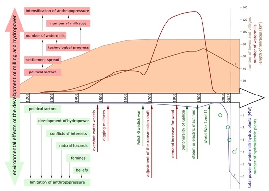
1. Introduction
Water milling and hydropower should be considered not only in terms of the use of water energy by humans, but also in the context of the impact of this activity on the natural environment. As much as 95% of the floodplains in Central Europe have been destroyed or transformed by man [
1]. It is believed that milling was one of the first manifestations of anthropopressure within river channels and floodplains [
2]. The construction of watermills and millraces also affected the flows, including flood flows, and sediment transport [
3]. Changes in the relief, on the other hand, were the cause of landscape changes [
4,
5], which could even lead to the creation of a specific type of landscape, the so-called molinotope [
6]. Millraces and mill ponds related to the historical milling industry, which have survived to this day, are considered archaeological objects for their era [
7]. On the other hand, modern hydropower is often considered a pro-environmental activity [
8].
From the sociohydrological point of view, the study of the causes and effects of anthropopressure should be supplemented with issues related to the development of communities [
9]. During a comprehensive analysis of dependencies, it is possible to capture the cultural causes of changes in the environment and predict their further impact on society [
10]. The beginning of the Anthropocene is considered to be the transition from processes dominated by nature to processes dominated by man. In the case of water systems, it is associated with the formation of the fluvial anthroposphere covering the river with its floodplains [
11]. Historical reasons for the initiation of anthropopressure in river systems, however, vary from region to region [
12]. The growing human impact on the environment can be traced through the study of the modification of natural conditions within the valley bottom resulting from, among other things, the reconstruction of the river network for the needs of the milling industry [
13].
According to Macklin and Lewin [
7], studying the complexity of the effects of anthropopressure associated with historical and contemporary human activity is essential for proper water management in the 21st century. This study aims to identify the causes and effects of the development of water energy use in the catchment area of a mountain river. The catchment of the River Skawa in the Polish Carpathians was selected, which, apart from its typical mountain cast of features, has a long kriging method documented history of human activity. The indirect goals included (1) studying the change in the number of water-using facilities over time since the beginning of their existence to the present day, (2) determining the types of activities that use water energy, (3) studying the direct environmental effects of the development of milling and hydropower, and (4) identifying the cultural causes of anthropopressure, taking into account the level of technological development of societies. This issue fits in with the goals of multidisciplinary works that Werther et al. [
14] considered necessary to answer the question of when and why humans became an important factor controlling the formation of floodplains in Central Europe. The problem of the impact of water milling on the natural environment in the mountains, despite the great popularity of this activity until the 19th century, has very rarely been analyzed [
15].
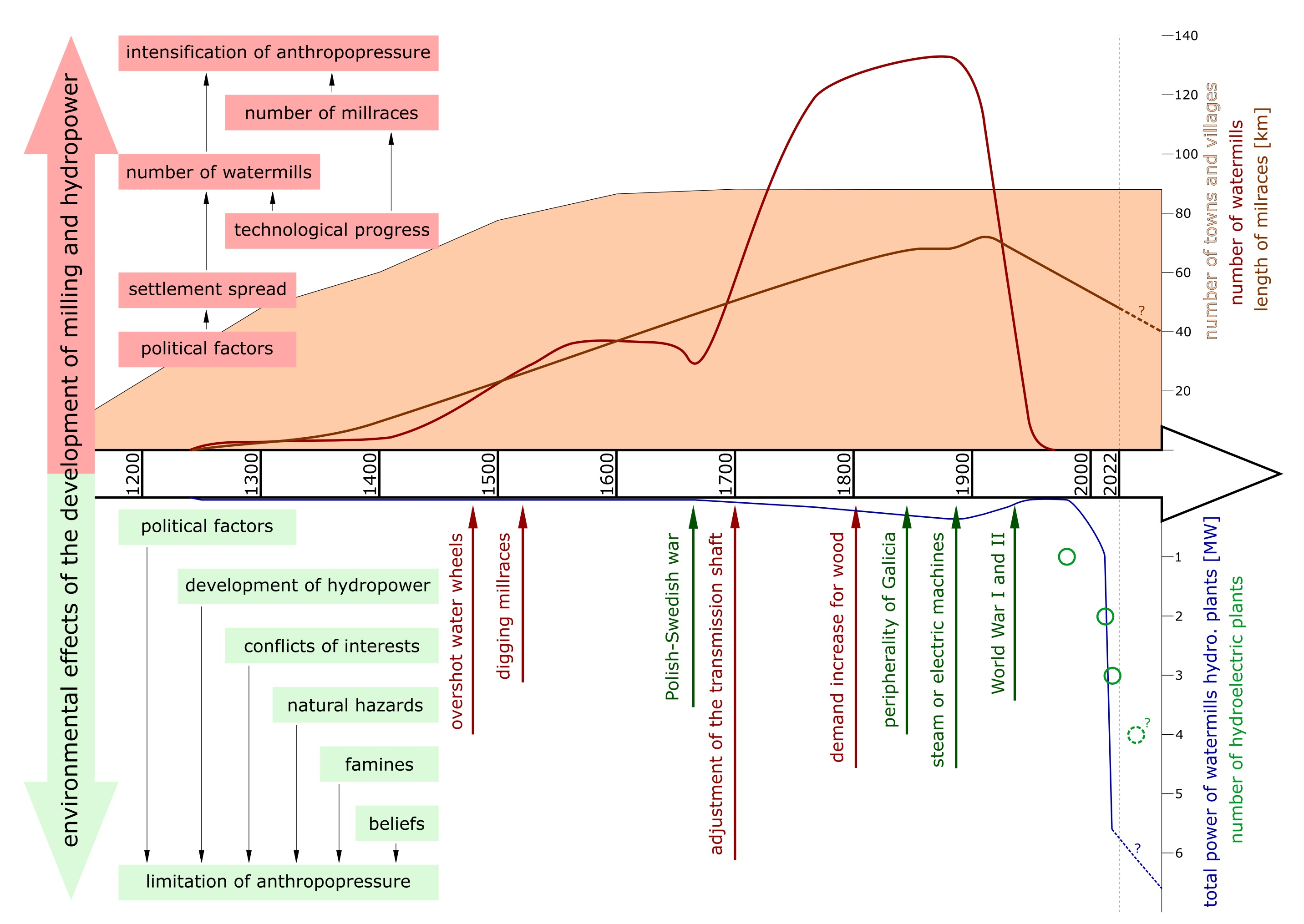
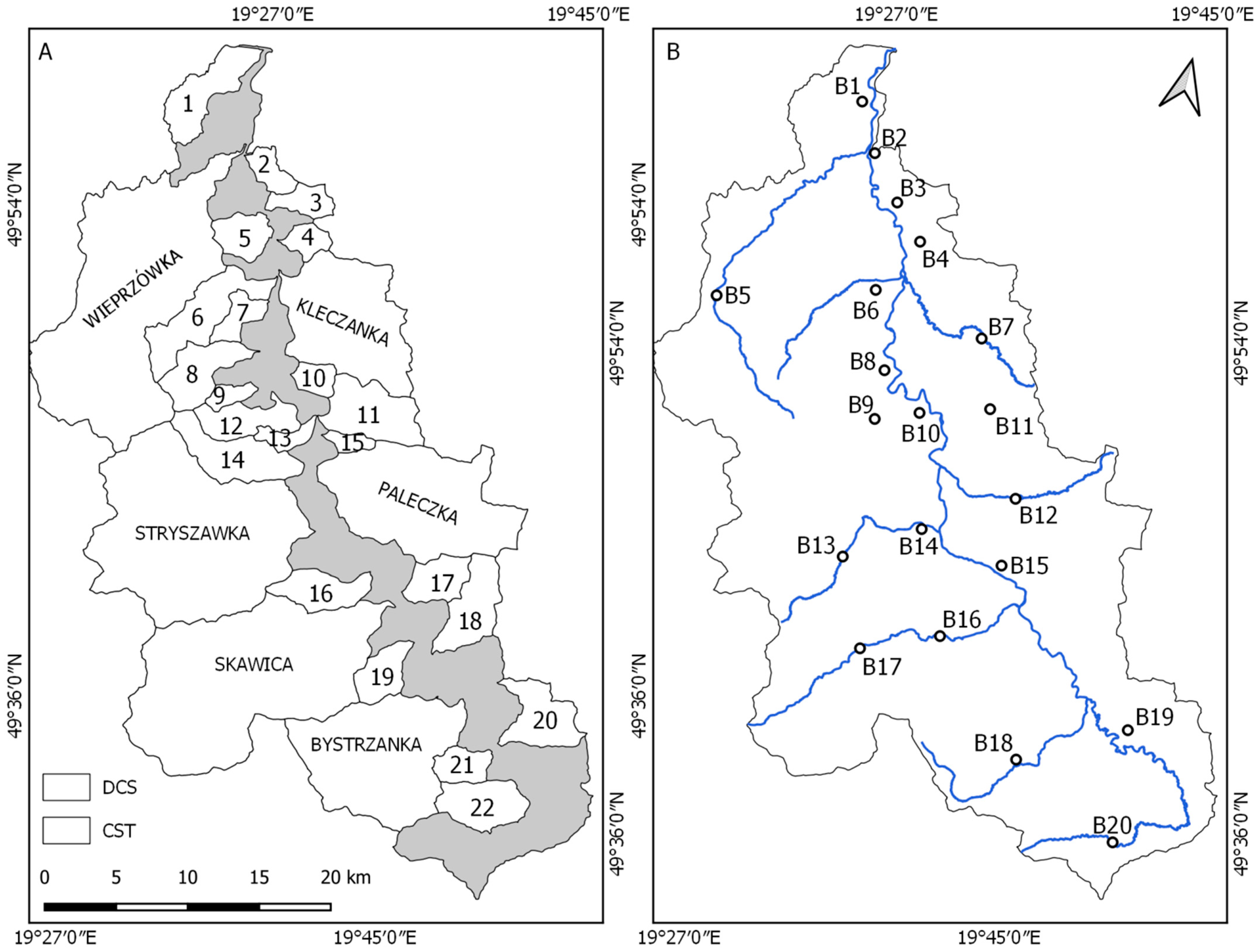
Research Area
The catchment area of the River Skawa, located in the Baltic Sea drainage basin in the Outer Western Carpathians in Poland, was selected as the research area (
Figure 1 and
Figure A1). The River Skawa is a right-bank tributary of the Vistula River. The length of the River Skawa is 103 km, and the catchment area is 1175 km
2 [
16]. In its upper reaches, the catchment of the River Skawa is located in middle-type mountains, i.e., in the Orawa-Jordanów Foothills and the Beskid Mountains. The springs of the Skawa River are located at an altitude about 700 m asl. The highest peak of the catchment is Babia Góra (1725 m asl). In the farthest part, the rivers drain the inter-mountain basin, the Orawa-Jordanów Foothills (the highest peak—Kiełek, 960 m asl), which belong to the Beskid Mountains. In its lower reaches, the River Skawa drains the Western Beskidian Foothills and the piedmont Oświęcim Basin (the mouth of the River Skawa is at an altitude of about 220 m asl). In their upper reaches, rivers have rock channels, while in the middle and lower runs, gravel channels. In pre-regulation conditions, the tributaries of the River Skawa had sinuous channels with braiding sections. The River Skawa, on the other hand, had very wide sections of the anabranching and braiding type [
17]. Following the 20th-century regulations, winding channels with rip-rap, and on the typically mountain tributaries channels with concrete barrages also appeared.
2. Methodology and Criticism of the Sources
In this article, all human activities that use the energy of water are referred to as water milling, as proposed by Walter and Merritts [
3], and all facilities that use the energy of water as watermills.
The study analyzed the number and location of devices powered by flowing water, which have been located in the River Skawa catchment area since the 13th century to the present day, thus throughout the period of permanent settlement in this area. This period is divided into two time intervals differing in terms of the sources of knowledge about mills: (I) 13th–18th centuries, only written sources; (II) 19th–21st century, mainly maps, but also statistical data.
Residual information about watermills from the beginning of the 1st period (13th–15th centuries) was obtained from the literature on regional history. Data on watermills from a later period were obtained from the inspections of royal estates carried out in 1564 [
19], 1659–1664 [
20] and 1765 [
21] (
Table A1). Watermills were inventoried very meticulously, often providing information about the number of water wheels, the owner, and the purpose of the device. Unfortunately, these data do not make it possible to indicate the exact location of the facilities. The issue of the supply watercourse was also very rarely mentioned in the inspections, so it is impossible to discuss the development of millraces on their basis.
The royal estates covered 44.6% of the River Skawa catchment area (in the second half of the 18th century it was 31 towns and villages). Unfortunately, the lack of inventories of estates belonging to the nobility and the Church from similar periods makes it impossible to calculate the actual number of watermills. Therefore, the number of watermills in the remaining non-royal estates was estimated taking the number of watermills in 1855 as a reference value. According to Munro [
2], the average power of a medieval water wheel was 2 HP (1.47 kW according to Equation (1)). On this basis, the power of the mills in 1564, 1659–1664, and 1765 was estimated.
Data for the second period include both the exact location of watermills as well as of artificial millraces. The study used: (1) the administrative map of the Kingdom of Galicia and Lodomeria together with the Grand Duchy of Kraków and the Duchy of Oświęcim, Zator, and Bukovina, the so-called Kummersberg map, from 1855, scale 1: 115,200 [
22]; (2) the map of the Austro-Hungarian monarchy (the so-called Spezialkarte), 1909, scale 1:75,000 [
23]. These maps were rectified, and the position of watermills and millraces was digitized. In addition, data on watermills located in Galicia in 1880 and 1930 were used, which were made available by the team of Ostafina et al. [
24]. Data from 1880 come from the updated Kummersberg map. Hence, slight differences in relation to the data from 1855. The data from 1930 were obtained from the maps of the Military Geographical Institute (Tactical Map of Poland) in the scale of 1:100,000.
By analysing the location of watermills on subsequent maps, it was determined which facilities were marked on more than one map. In this way, the “mills location” layer was created, taking into account all locations.
Statistical data were also used in the study. In the statistical yearbooks for Galicia, which were published annually in the period 1886–1913, only the first edition [
25] presents data on the number of watermills. The number of water wheels and turbines as well as their total power expressed in horsepower were provided (
Table 1). In 1886, the River Skawa catchment area was within the administrative boundaries of 3 poviats: Wadowice poviat (43% of the catchment area), Myślenice poviat (42.4%), and Żywiec poviat (14.6%).
Using the averaged data from
Table 1, the estimated power expressed in kW, which was obtained by converting the average value of power expressed in horsepower for a gristmill or a sawmill into kW according to the dependencies, was added to the attributes of gristmills and sawmills:
Among the facilities listed in the table as ‘others’, the following facilities were included in the River Skawa catchment area: fulling mills and paper mills from the Wadowice poviat (3 facilities) and the Żywiec poviat (10 facilities). However, on the basis of the analyzed maps, they cannot be distinguished from the group of the facilities marked with the signature of a water wheel. It can be said with certainty that the forges from the Żywiec poviat presented in the table were not located in the River Skawa catchment area.
Along with the analysis of the development of milling and its impact on the aquatic environment, social changes that determined the approach to the use of water energy were recorded. This information was provided by the literature on regional history as well as by statistical data. In this way, all components of the sociohydrological analysis were included.
4. The Impact of Water Energy Use on the Natural Environment
Out of 44 artificial watercourses identified on the analyzed maps, as many as 41 were built as millraces. Three facilities were created for a different purpose and were adapted to be millraces. The oldest of them is the Zator millrace, supplied by the Wieprzówka, which could have been built at the turn of the 14th and 15th centuries, when man began to introduce the first significant changes to the river network in the River Skawa catchment area for the supplying of fish ponds with water. The Tomice millrace was also built to supply the complex of fish ponds with water in the 16th century [
26]. On the other hand, the Andrychów millrace was dug in the first half of the 17th century as a source for the defensive moat of the Andrychów manor [
35].
In 1909, the total length of the millraces in the River Skawa catchment area reached its highest value of 72.5 km (
Table 5). In the southern, source part of the catchment, in the Orawa-Jordanów Foothills, there were five short millraces (0.65–1.6 km long) with a total length of 3.2 km. Further, 24 millraces were dug in the Beskid Mountains (24.6 km in total), 23 of them were less than 2.52 km long, and one (the Maków millrace) was 3.9 km long. Further, 11 millraces (a total of 22.6 km) were located in the Western Beskidian Foothills. Only four millraces (22.1 km in total) were located in the Oświęcim Basin, including the longest millraces in the River Skawa catchment area, the Wieprz millrace (10 km) and the Zator millrace (9.2 km).
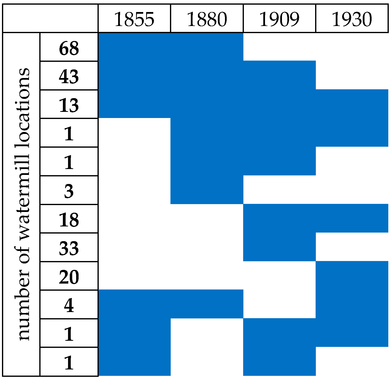
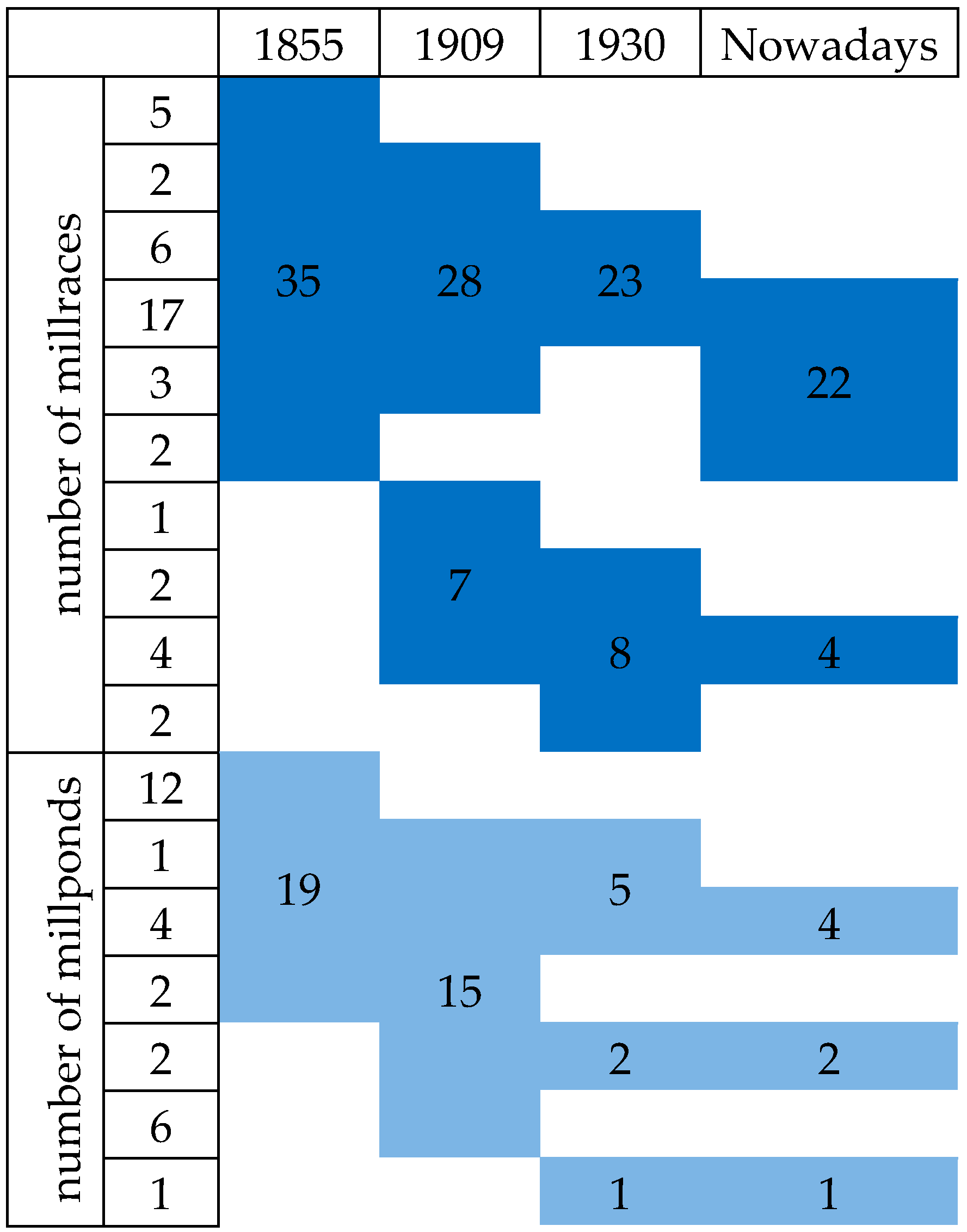
In the period 1855–1930, there were 44 functioning millraces, of which eight were marked only on one of the maps and no traces of them have survived (
Figure 5). These were short millraces, 287–1579 m long, over which only one watermill worked. Another 10 millraces were marked on two or three maps, but no traces of them have remained either. Traces of 26 millraces have survived to this day, and three of them have survived in their entirety. In the case of 32 millraces, no or insignificant changes in length were found during their operation. Eight millraces were lengthened in the 20th century and four were shortened.
The construction of 44 artificial millraces with a total length of approximately 70 km resulted in an increase in the density of the river network in the transformed valley bottoms. Further, 19 millraces did not receive any watercourses. Their length did not exceed 2.4 km. 10 millraces were additionally supplied by one watercourse. Their length did not exceed 2 km. Seven millraces were additionally supplied by two watercourses. The longest of them was 4.3 km. Four millraces received three additional watercourses. The longest of them, the Wadowice millrace, was 7 km long. Two millraces received four watercourses each. In the mountains, the Budzów millrace was only 1.6 km long, and the Wieprzówka millrace in the Oświęcim Basin was 10 km long. The largest number of additional watercourses was received by the mountain Maków millrace (6.5 km long), i.e., as many as 10.
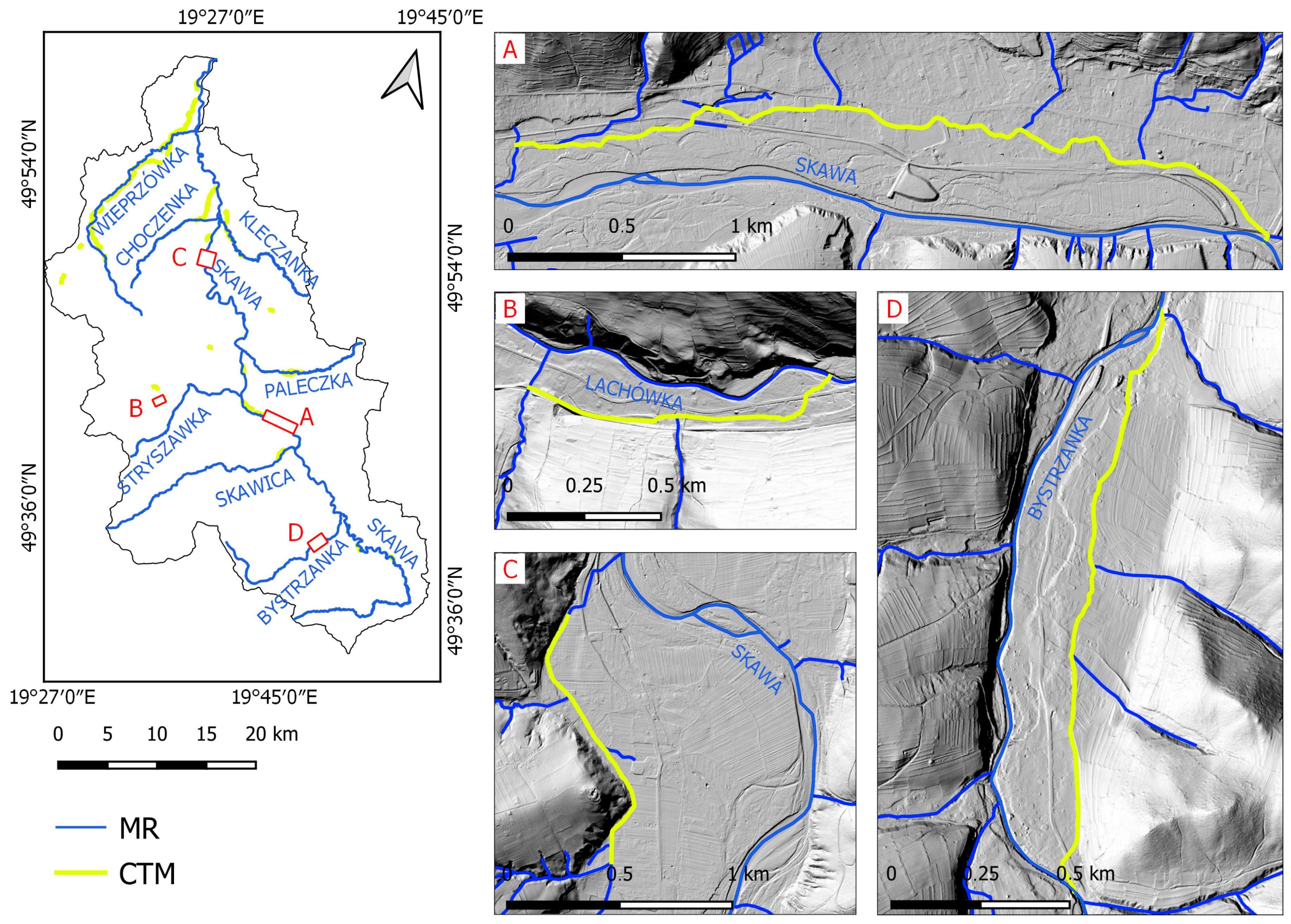
Traces of 26 millraces with a total length of 48.1 km have survived to this day (
Figure 6). An important role in water management is still played by the Zator and Tomice millraces, which are almost completely preserved and supply fishponds. Moreover, 15 sections of the millraces have survived because they have been left as sections of stream channels. Owing to the existing sections of the millraces, 35 watercourses have changed their course or lost their natural mouths. The Maków millrace, with three sections remaining, still changes the course of eight tributaries of the River Skawa (
Figure 6). The other 10 sections of the millraces do not affect the course of the natural river network, being side channels usually filled with water. In the River Skawa catchment area, today, there are 3112.7 km of open channels [
36], including artificial channels built to supply fish ponds or as flood control channels or derivative canals. The remains of the former millraces (48.1 km) constitute as much as 1.5% of this contemporary river network.
Weirs on 20 natural rivers were built in the entire River Skawa catchment area in the period 1855–1930 in order to supply millraces. In the case of short millraces, the flow in them can be estimated at a level of 0.1 m
3/s, but in the case of large ones, e.g., in the Wadowice millrace, the measured flow reached as much as 2.5 m
3/s [
29]. They caused the distribution of water over a much larger area, thus affecting the increase in the level of groundwater. Weirs were also an obstacle in the transport of gravel and forced its deposition.
Mill ponds affected in particular the flow conditions in the millraces and watercourses into which the millraces flowed. Watermills operated during the day and, therefore, the discharge of the pond water was much greater during the day than at night, which resulted in fluctuating flows. Unfortunately, these changes are impossible to reproduce. Undoubtedly, mill ponds marked a change in the water network and in the relief. Most mill ponds were marked on the map from 1855. They were located both in the Wastern Beskidian Foothills and in the Beskid Mountains. At that time, eight out of 19 ponds operated at millraces. To this day, seven mill ponds have been preserved.
The direct impact of the three existing hydroelectric plants on the natural environment cannot be determined. All of the power plants are located next to hydrotechnical facilities, which were built for a purpose other than the damming of water for the purposes of the power industry. Moreover, all of the power plants operate in a flow-through mode, so there are no discharges disrupting the natural flow. However, the impact of the damming structures next to which the existing power plants are located on the natural environment is unquestionable.
5. Discussion
Along with their appearance in the River Skawa catchment area, humans began to use the fluvial environment. The first fish ponds were established near Zator in the 13th century within the oxbow lakes which constituted natural pools [
26]. The first watermills, on the other hand, were built over natural watercourses with the simplest undershot water wheels installed in them. These devices did not require the damming of water, which was a skill unknown in southern Poland until the end of the 15th century [
37]. The period until the end of the 15th century was distinguished by the ability to use the fluvial environment in its natural state. Watermills of that time, having 2 HP water wheels, could replace the work of 30–60 people who would grind the grain by hand. Moreover, as early as in the Middle Ages, a watermill made it possible to save the capital and grain which would be needed to obtain the same energy in horse mills [
2]. The rapid development of milling, causing changes in the medieval river network, was considered to be part of the “medieval industrial revolution” [
38].
Starting in the 16th century, man began to exert noticeable pressure on the fluvial environment. According to Baranowski [
37], water milling in the Kingdom of Poland was the most important branch of industrial production from the 16th to the 18th century. Watermills were already being built then regardless of natural conditions. Despite this, no mill settlements were found in which the watermill was an impulse to establish a new town or village [
39]. The onset of anthropopressure on the floodplain is, therefore, associated with settlement, the progress of which was a result of the clash of various political influences in the Silesian-Krakow borderland [
40].
The number of watermills in the River Skawa catchment area increased successively until around 1880 and then declined. In Western Europe, the flourishing development of milling peaked at the beginning of the 19th century [
6]. The peak of the milling development in the River Skawa catchment area fell on the last wet phase of the Little Ice Age [
41], which is confirmed by the high frequency of floods in Europe [
42]. The upward trend was disturbed at the end of the 17th century as a result of the Polish-Swedish war [
43]. Gristmills were often the target of attacks as facilities for the provision of enemy troops [
6]. The reduction of human pressure on the environment, as a result of the regression in milling, was, therefore, politically motivated. The reconstruction of the post-war damage began at a time when the technical level of milling had risen significantly. The adjustment of the position of the transmission shaft, popular since the 18th century, made it possible to avoid damage during minor floods. It was particularly important at that time because in the Kingdom of Poland approximately 1.6–2% of the population lived off milling [
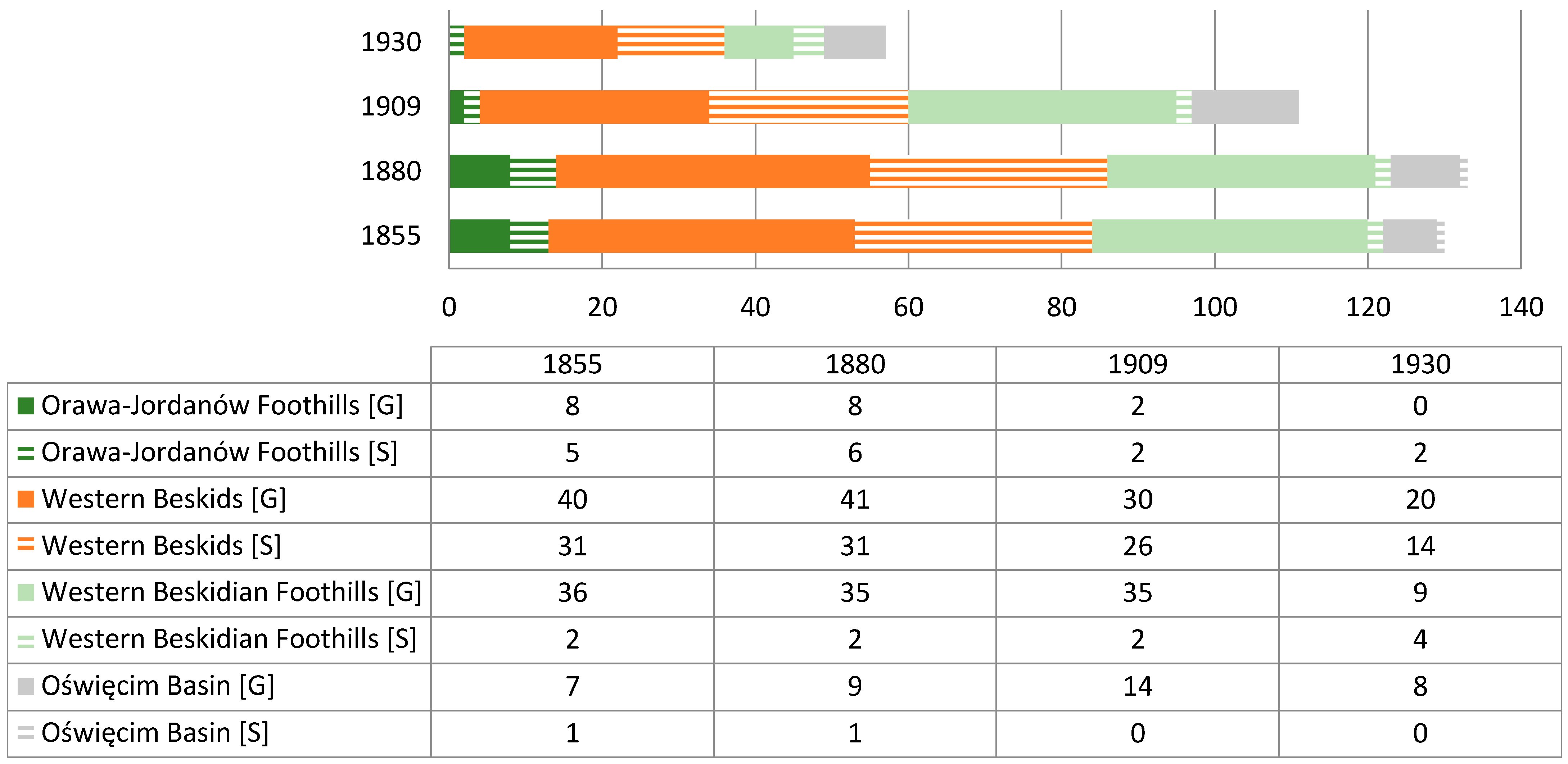
37].
In the 19th and 20th centuries, watermills were established most often in the Beskid Mountains, and, in the second place, in the Western Beskidian Foothills. This resulted from the natural conditions in the River Skawa catchment area. The greater density of sawmills in western Galicia resulted from the location of nearby markets for wood, i.e., Silesia and Kraków, numerous ironworks, and the policy of the owners of goods focused on the acquisition of wood [
24].
In 1885, in the whole of Galicia, 7829 people were employed in water milling, which constituted 9.4% of people working in industry. These data confirm the important role of watermills in the underdeveloped Galician industry. At that time, water sawmills accounted for 88% of all saw mills, and water gristmills accounted for 97% of the total number of gristmills [
25]. At the end of the 19th century, Galician milling and sawmilling were dominated by watermills, while in Europe steam or electric machines were used more and more often for propulsion [
44]. The level of development of Galician milling in the 19th century was, therefore, the result of natural conditions and political factors. The slight pressure on the flood plains in the River Skawa catchment area and in the whole of Galicia, compared to other parts of the Habsburg Empire [
45,
46,
47], was the result of the country’s political and economic peripherality.
Watermills were exposed to destruction during floods and fires, but their existence was also closely related to the economic situation. Declines in the number of gristmills or at least their short-term shutdowns probably also took place during famines, especially in the 19th century [
48], but the analyzed sources do not support this thesis. Owing to these factors, a watermill in a given location did not always work for a long period of time. On the other hand, in lowland areas, the durability of one location reached as many as 700 years [
6]. In the River Skawa catchment area, it also happened that the type of devices was changed, or transmission devices were adapted to work for both grain grinding and wood cutting.
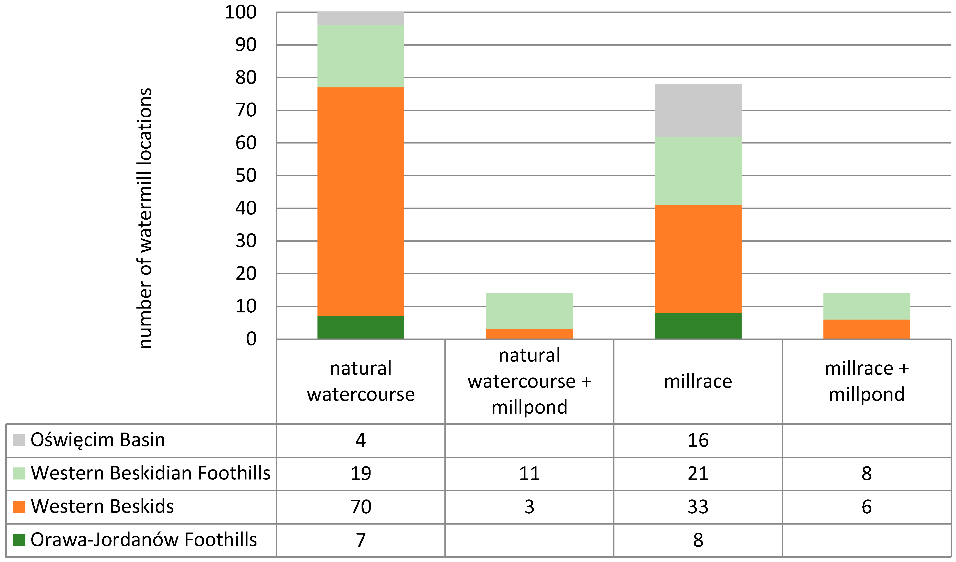
The development of the use of water energy was possible thanks to the acquisition of the ability to dam water for overshot water wheels and to dig millraces. Therefore, the development of milling reflects the technical progress that was taking place among the local population. More than half of the 19th and 20th-century locations of watermills in the River Skawa catchment area were found at millraces or mill ponds. The longest millraces were dug in the Oświęcim Basin, where the relief was the least diversified. Mill ponds in the River Skawa catchment area were in addition, rarely dug, and then only in the Beskid Mountains and at the Western Beskidian Foothills. In the case of mill ponds in the UK, it was noted that those in mountainous areas provided additional security for the water supply, as river slopes were sufficient to power watermills [
49]. Moreover, ponds in the mountains were rarely dug owing to terrain difficulties [
50].
The construction of millraces caused changes in the relief and water distribution in the catchment area, which resulted in an increase in the groundwater level. According to Kaiser et al. [
51], the first changes in the water balance of German rivers were caused precisely by the construction of weirs at watermills. The construction of watermills on the Havel in the 13th century resulted in an increase in the groundwater level and the spread of peatland [
52]. Traces of millraces with a total length of 48.1 km have survived to this day, accounting for 1.5% of the contemporary river network in the River Skawa catchment area. The existing sections of millraces change the course of 35 streams. Also, 7 mill ponds have survived. Both the non-existent sections of millraces and those still existing today should be taken into account when designing renaturalization activities [
53]. Weirs, on the other hand, were an obstacle in the transport of gravel and forced its deposition. Until the end of the 19th century, this process probably had a slight impact on the sediment balance in the main watercourse of the catchment, which had a multi-thread channel. On the other hand, at the beginning of the 20th century, when the regulation of the River Skawa and its tributaries began, the supply of sediment through weirs was significantly limited, contributing to the initiation of rapid and intensive channel incision [
54]. The high level of groundwater in the Carpathian valleys was prevented from the second half of the 19th century using agricultural drainage [
33]. Until the mid-twentieth century, raising the groundwater level was a major obstacle to the cultivation of land, especially in the flat parts of mountain valleys. In France, on the other hand, agricultural drainage on the Rhine valley had been carried out a hundred years earlier [
55]. The subsequent liquidation of millraces, especially weirs, starting in the 1940s, resulted in an increase in flows in natural watercourses [
30]. In the case of watermills on the Wurm River, it was found that channel incision was triggered by the liquidation of the weir [
56]. Similar effects were observed in the USA [
3].
In the middle and lower reaches of the River Skawa, under natural conditions, there were several anabranching or braiding sections [
17], which were too unstable for watermills to be established on them. The problem was both the frequent changes in the relief and the large fluctuations in the flow divided into several threads. Weirs were built in the channel of the River Skawa, damming water for millraces, which bypassed the multi-thread sections of the river. However, these weirs were a problem for the timber rafting [
26]. At the turn of the 19th and 20th centuries, Galicia began to consider building a network of waterways, which meant that the full patency of channels was expected [
33,
57]. For this reason, at the beginning of the 20th century, the only weir in the lower reaches of the River Skawa was equipped with a ramp for the rafting [
30]. However, the subordination of milling to other forms of economic activity was not the norm in Europe. In the River Elbe catchment area, watermills took priority over the interests of agriculture which, through the construction of numerous weirs, resulted in the consolidation of large swamps, which made it difficult to cultivate the land [
52].
Building a watermill required knowledge, skills, and permission. For this reason, as early as in the 16th century, in the River Skawa catchment area, it was mainly village leaders that became millers [
19]. Watermills were associated with class oppression and the wealthy miller was treated as someone who wanted to cheat the farmer. Fears concerning honesty were additionally fueled by the superstition of uneducated peasants who believed that in order to build a watermill and control flowing water, it was necessary to use satanic forces. It was a common phenomenon throughout Europe, which persisted in many, especially mountain villages, until the beginning of the 20th century [
58]. Therefore, beliefs limited the demand for milling services.
The average power generated by gristmills in the River Skawa catchment in the 19th century did not exceed 4 kW, and by sawmills—7 kW. These values are lower than for the entire territory of Poland, where the average power of gristmills was estimated at 6–7.5 kW [
44]. The reasons for this difference lie in the low technological level in Galicia and in more difficult terrain conditions than in the lowlands. On the other hand, the average power of devices serving other purposes in the River Skawa catchment, such as paper mills, was much higher, even 21 kW. Such big differences result from the different technical requirements of the facilities.
The economic backwardness of Galicia [
59] meant that at the turn of the 19th and 20th centuries, mill wheels were very rarely replaced with much more efficient water turbines, despite the fact that there was a need to develop both large hydropower for the needs of the country and small hydropower for individual facilities or housing estates [
60]. Watermills were replaced just as reluctantly with steam mills. In Galicia, watermills were occasionally transformed into power plants. On the other hand, in the northern part of contemporary Poland, at the end of the 19th century, the first large hydroelectric plants [
61] began to be built, similarly to Western Europe [
62]. Along with the failure to implement the project of building a power plant in the River Skawa valley at the beginning of the 20th century [
29], the era of using water forces in the River Skawa catchment area, lasting continuously since the 13th century, ended. Only in the sub-catchment of the Skawica River, with the highest energy potential, did individual sawmills operate in the second half of the 20th century [
63].
The gradual decommissioning of water wheel-driven devices was a process expected by society. The decommissioning was related to technical advances that increased the efficiency of devices and reduced the workload of employees. The abandonment of water wheels also reduced human dependence on the shortage or excess of water. Devices could be installed in a place convenient for the owner, not necessarily close to the river. The technological displacement of the water drive also displaced water milling from the local identity. Out of the thousands of Galician watermills still operating at the beginning of the 20th century, only a dozen have remained, most of them moved to open-air museums [
64]. Nevertheless, there is a tourist potential in the traces of water milling, both in the locations of watermills [
65] and in restored facilities [
66].
At the beginning of the 20th century, despite the plans [
29], the hydropower potential of the rivers in the River Skawa catchment area was not used. The hydrotechnical facilities with three hydroelectric power plants in the River Skawa catchment area were built for other purposes. This is particularly important in the context of the Świnna Poręba reservoir, the construction of which had a huge impact on the local community displaced from the reservoir bowl [
67]. However, in this case, the negative human impact on the fluvial and social environment should not be linked to the development of hydropower.
The use of water for human needs without taking into account environmental costs is in line with the general trend prevailing during the industrial revolution in the world. The construction of millraces, weirs, and watergates was an element of the conquest of nature, showing the possibilities of man to subordinate these unfavorable forces to himself [
68,
69]. Traces of negative historical human impact on the environment are particularly visible in post-socialist countries [
70].
Important from the point of view of sustainable development is the RESTORE Hydro project, which assumes the possibility of building a hydroelectric power plant in the places of the existing weirs [
8]. The environmental impact of many of these barriers is significant and the benefits of their existence are relatively small at present. For this reason, many of them could be dismantled, but it is a time-consuming and cost-intensive process, as evidenced by a small number of such activities in Poland [
71]. So far, no weir in the River Skawa catchment area has been dismantled. The construction of hydroelectric power plants at the existing weirs would reduce human impact on the environment by increasing the production of renewable energy while using to this end the facilities negatively affecting the environment. The interest in the development of such hydropower is low, mainly due to small production capacities in relation to huge investment costs. However, Scotland has proven that such a compromise is acceptable [
62].
It is necessary to continue research on changes in the fluvial environment in the context of the historical human economy. These studies will make it possible to accurately capture the time of the onset of anthropopressure and will make it possible for us to look at the effects of human activity, which, although it is of a local nature, covers areas with a large surface. The inclusion of human activity in research not only as a source of pressure allows for full recognition of the conditions of the environment functioning. Continuing the thought of Werther et al. [
14], the importance of multidisciplinary work involving the study of changes in the natural environment in the context of human activity, with particular emphasis on feedback loops, should be emphasized. In the case of research on fluvial anthropospheres, it is necessary to (1) identify changes in the natural environment, (2) trace the history of human activity in the fluvial environment, and (3) define interrelationships. Such analyses will significantly facilitate the management of riverside areas in the spirit of sustainable development.


