1. Introduction
Landfills represent a variety of potential local sources of environmental pollution. One of the main hazards related with landfilling is the generation of leachate [
1,
2,
3]. After the leachate has permeated the waste deposits and reached the groundwater and surface water, it may cause contamination in the wider environment. Contamination in groundwater may remain for decades or even centuries. Because landfills have the potential to produce leachate for several hundred years, a proper operation of all landfill systems must be ensured during the period of landfill closure. Public concern and awareness of environmental protection has grown worldwide, which is also considered in the development of environmental legislation in various countries [
4]. In Europe, the requirements of the Waste Framework Directive 2006/12/EC are designed to prevent or reduce, as much as possible, the negative effects of landfilling on the environment and any resulting risks to humans monitoring the potential impact of landfills on the environment, as well as on groundwater. Groundwater monitoring at landfills is a crucial measure in minimizing and controlling the risk of pollution and is one of the first instruments required and regulated by national or international legislation. The Landfill Directive (1991–1999/31/EC) established the rules for determining a significant change in groundwater quality due to the unfavorable environmental impact of a landfill, which should be determined on the basis of a representative hydrogeological conceptual model and the establishment of appropriate criteria before landfilling activities begin.
Several toxic and harmful contaminants can migrate directly from landfill leachate to groundwater [
5,
6,
7,
8], consisting of inorganic compounds, organic contaminants, and xenobiotics [
9]. Leachate can also cause reductive redox potentials in groundwater and affect the alteration of individual substances, thus negatively affecting the chemical status of groundwater [
10]. In recent years, numerous studies have been published on the determination of physicochemical parameters of leachate [
11,
12,
13] and their impact on groundwater under waste fields [
14,
15,
16]. In most cases, groundwater quality is assessed by determining chemical and/or microbiological parameters and comparing the data with existing threshold values [
15,
17,
18]. Such an approach provides information only on specific pollutants and, therefore, provides little information on general water quality. A more comprehensive description of the groundwater quality in the vicinity of the landfill can be obtained by different summary indices based on measurements of individual parameters, such as leachate pollution index (LPI) [
11,
19], water quality index (WQI) [
20] and a modified WQI called the landfill water pollution index (LWPI) [
21,
22], and Nemerow index (PI) [
23]. In fact, the generation of quality indices allows a synthesis of the results of environmental quality assessment so that it can be understood by nonexperts such as the public/stakeholders involved in decision making. In the last decade, many researchers also focused on assessing the impact of landfilling on groundwater quality using the risk assessment method, which is an ever-evolving assessment tool. The literature review on landfill risk assessment conducted by Butt et al. [
4] highlighted that there is no such holistic risk assessment methodology for landfill leachate that could help carry out the risk assessment process from the beginning (i.e., baseline study) to the end (i.e., hazard indices and risk quantification). One of the problems of landfill impact assessment is the determination of background conditions in the landfill area [
8,
16]. Several appropriate waste management strategies have been developed to support the assessment of background conditions at the local scale [
24]. However, in many real conditions, the monitoring network was established after the start of landfill activities or without adequate knowledge of the in situ hydrogeological conditions. Previous studies [
24,
25,
26,
27] have indicated that natural backgrounds can only be determined from a representative geochemical set by sampling groundwater. High metal levels exceeding groundwater acceptable threshold values are broadly and pre-emptively correlated to local pollution, completely ignoring the geogenic natural background levels [
8].
In Europe, as well as in Slovenia, the disposal of waste in landfills and the assessment of its impact on groundwater and surface water status are regulated by regulations derived from EU legislation (Waste Framework Directive 2006/12/EC). It was recognized most recently that most of the landfills have an impact on local groundwater quality status; therefore, it is also necessary to assess which of these landfills threaten the chemical status of groundwater bodies on a regional scale [
28], which is very important for the state management of water resources. The impact of the landfill on groundwater status must be assessed on the basis of the chemical characteristics of groundwater, as well as on geogenic and other external parameters (reliability of the monitoring network, interaction between surface water and groundwater, and higher upgradient chemical concentrations in groundwater). A relevant assessment of the impact of the landfill on groundwater requires the analysis of the possible consequences caused by the impact of the landfill on the degradation of groundwater-dependent ecosystems and drinking water supply.
All these uncertainties have led us to develop a relevant approach to assess the impact of the landfill on groundwater status by considering conceptual models of the landfill site. The article presents a risk assessment of the pollution impact on groundwater from landfills based on the reviewed monitoring reports in Slovenia. All landfills were divided into classes according to the degree of risk of pollution, providing insight into the status of the landfills in relation to landfill management practices and providing the basis for alternative corrective actions.
The proposed method focuses on estimating the relationship between key chemical parameters, and it also considers conceptual models of the landfills. The study had the following objectives: (I) to develop an integrated method for classifying landfills on the basis of groundwater chemical data and conceptual models of landfills, (II) to identify the main groundwater pollutants in the vicinity of landfills according to type and status of the landfills, (III) to assess the impact of landfills on groundwater in the case of Slovenia, and (IV) to classify landfills in Slovenia according to developed integrated method.
2. Material and Methods
2.1. Study Area
Slovenia is a European country that is surrounded by the Alps, Mediterranean Sea, and Central Europe. With an area of 20,273 km2, Slovenia is one of the smallest European countries. It has about two million inhabitants.
In 2019, about 8.4 million tons of waste were generated, of which about 1.1 tons or 509 kg per capita was municipal waste with an annual increasing trend (426 kg per capita in 2002). Approximately 775,000 tons or 73% of municipal waste was collected separately, and this proportion also increased from 8.6% in 2002 to 73% in 2019, while the proportion of landfilled municipal waste decreased (from 84% in 2002 to 6.3% in 2019) due to the increased waste recycling rate (from 63% in 2010 to 85% in 2019) [
29].
Slovenia has some of the richest groundwater resources in Europe. Over 97% of the population gets its drinking water from groundwater resources. Groundwater also represents an important source of technical water in industry, as well as for energy production, food industry, agriculture, and tourism.
The geological structure of Slovenia is very diverse in terms of age (from Early Paleozoic to the present), lithology, and tectonics. Due to this geological diversity, the geological structure of the area is very complex [
30], which makes the task of modeling groundwater properties even more challenging. The most abundant rock type is sedimentary, covering about 93% of the country, while igneous and metamorphic rocks cover much smaller areas, 3% and 4%, respectively [
31]. Groundwater occurs in different geological structures. According to the type of porosity, aquifers can be divided into aquifers with intergranular, fissured, and karstic porosity (
Figure 1). About 14% of the area is gravel/sandy deposits with intergranular porosity, 45% of the area is represented by karstic/fissured aquifers, and 35% of the area is represented by minor aquifers in porous or fissured formations with local and limited groundwater resources. Overlying strata or layers with essentially no significant groundwater resources comprise some 6% of the area [
32].
2.2. Overview of Landfill Characteristics and Spatial Distribution
A total of 69 landfills were included in the analysis. Municipal solid waste type of landfill predominates (50 landfills or 72%) (
Table 1), while seven (10%) landfills are inert waste type, 10 landfills are nonhazardous waste type (15%), and two landfills (3%) are hazardous waste type. In addition, 14 active landfills (10 municipal, one inert, one hazardous, and two nonhazardous landfills), 15 closure phase landfills (12 municipal and three inert landfills), and 40 closed landfills (28 municipal, three inert, one hazardous, and eight nonhazardous landfills) are monitored. Additional information is given in the
Supplementary Material S1 (sheet “class”), i.e., the size and engineering characteristics of the landfill body, the main hydrogeological characteristics in the designated area of the landfill, possible receptors for each landfill, and the suitability of the monitoring system. The impact assessment of the landfill on groundwater quality and the evaluation of the reliability of the assessment are also presented.
2.2.1. Landfill Characteristics—Engineering Disposition of the Landfill
An adequate engineering disposition (R) required by the regulation in Slovenia has 23 landfills. This means that the sealing of the ground with a clayey layer and PEHD foil is provided, and the collection of the leachate by drainage system to retention basins or to treatment plants is on place. A partially settled (P) liner and/or drainage system has 34 landfills. Most of these landfills consist of an old and a new part of the landfill. The old parts are usually not underlined by impervious foil but only the clayey layer lies in the base of the waste. The newer parts of landfills are underlined by PEHD foil, or the waste is located exclusively on natural, poorly permeable sediments (clay and marl). In these landfills, leachate drainage is partially adequate, due to either an ineffective wastewater treatment plant or the old part of the landfill not having operational drainage, while the new part of the landfill does. Engineering characteristics of 12 landfills are unregulated (U). The waste is deposited directly on permeable layers (gravel and carbonate rock), the drainage system is not adequate, and the leachate infiltrates into the subsoil.
2.2.2. Spatial Distribution—Natural Characteristics of the Site of the Landfill
The natural characteristics of the site and downgradient area represent the primary factor for the extent of the landfill’s impact on groundwater quality (permanent or temporary). Therefore, the primary analysis was conducted with the aid of a hydrogeological map (
Figure 1) representing basic aquifer types [
32].
Table 1 shows that 23 of 69 landfills are located on intergranular aquifers (three active), 23 (five active) are located on karstic/fissured aquifers, and 23 (six active) are located on minor aquifers with local and limited groundwater resources.
Moreover, 17 landfills are located in the areas of the most important aquifers (type I.a and II.a), which represents about 25% of all landfills in Slovenia. Their medium to high productivity and regional extent make the potential of these aquifers very important for drinking water supply, presently and in the future.
There are 14 landfills (five active) situated in water protection zones (GWPZs) (
Table 1). Only one landfill (closed) is located directly in the groundwater-dependent ecosystem area (GDE), while 10 landfills extend into the GDE area via their “hydrogeologic target zones”.
2.3. Source of Data
The dataset was obtained from the Slovenian Environment Agency (ARSO) within the Ministry of the Environment and Spatial Planning, including 82 landfills from the whole territory of Slovenia. Annual monitoring, which represents the basis to determine and assess the landfill leaching effect on groundwater, is conducted at 68 landfills, while monitoring is not yet performed for one landfill. Monitoring was abandoned at 13 landfills where it was demonstrated that pollution is not spreading to groundwater (
Figure 1). Thus, the developed integrated methodology was tested at 68 landfills.
Data on the main hydrogeological characteristics of the landfill, the engineering characteristics of the landfill, and the results of groundwater chemical monitoring were obtained. Representative groundwater quality data were collected for 65 landfills in 2017. At three landfills, no monitoring was conducted in this year. For these landfills, monitoring data from the most recent available year until 2017 were used.
2.4. Groundwater Monitoring at the Landfill Area
2.4.1. Groundwater Monitoring Network and Sampling
The monitoring network at the landfills consisted of a minimum of three monitoring points, of which at least two monitoring points were located downgradient and one monitoring point was located upgradient of the landfill (
Figure 2). Groundwater chemical monitoring was conducted in the target hydrogeologic zone where contamination could be expected due to indirect or direct discharge of contaminants from a source of contamination to groundwater.
The sampling set on karst aquifers consisted mostly of springs and to a lesser extent boreholes. The distances between monitoring points were in most cases greater than 10 km. However, on intergranular aquifers and aquifers with local and limited groundwater resources the sampling set consisted of boreholes, private wells and pumping stations.
Annual monitoring of the landfill impact on groundwater quality was carried out by various accredited laboratories in Slovenia, such as the National Laboratory for Health, Environment and Food, Eurofins Erico Slovenija d.o.o., JP Vodovod Kanalizacija Snaga d.o.o., Talum Inštitut d.o.o., Tab-Ipm Logistika, Plastika In Storitve d.o.o., and Regionalni tehnološki center Zasavje d.o.o. Groundwater sampling in areas where karst porosity prevails was performed four times per year, one in each season. In the areas with fissured and intergranular porosity, groundwater sampling was performed twice per year with the sampling interval of at least 3 months and no longer than 6 months. In general, sampling campaigns were conducted under hydrogeological baseflow conditions (predominant discharge from aquifer storage).
Sampling procedures, transport, and storage of the groundwater samples were performed in accordance with ISO standards (SIST ISO 5677-11:1996; SIST ISO 5677-03:1996; SIST ISO 5677-6:1996).
2.4.2. Chemical Analysis
The groundwater samples were analyzed at the accredited laboratories in Slovenia mentioned in the previous section.
In our study, field parameters (temperature, pH, electrical conductivity, dissolved oxygen, and redox potential), inorganic parameters (Na
+, K
+, Ca
2+, Mg
2+, NH
4+, HCO
3−, SO
42−, Cl
−, NO
3−, F
−, NO
2−, and PO
43−), microelements (B, Al, As, Sb, Cu, Ba, Be, Zn, Cd, Co, Sn, Cr total, Cr
6+, Mo, Mn, Ni, Se, Ag, Pb, Tl, Ti, Te, V, Fe, and Hg), and organic compounds (total organic carbon (TOC), adsorbable organic halides (AOX), volatile organic compounds (VOCs), aromatic hydrocarbons (BTEX), triazine, and organochlorine pesticides) in groundwater were recorded. For microelements, dissolved species in groundwater were measured. The organic compounds included in the monitoring were selected on the basis of the type of waste and the results of the groundwater zero status.
Table 2 shows the analytical procedure used for each chemical parameter and measurement uncertainties.
2.4.3. Evaluation of Chemical Data
Chemical groundwater monitoring datasets were presented up to the concentration values of the lower limit of quantification (LOQ). LOQ values varied for individual parameters on a case-by-case basis, between individual measurement series, and by laboratory. The highest LOQ values of each parameter were used for analysis. All numerical results below the selected value of LOQ were considered results at LOQ. For data at LOQ, 50% of the LOQ values were used for further data processing in accordance with the recommendation in Annex 3 of the National Regulation on groundwater status.
The impact of landfills on groundwater was firstly assessed by comparing the annual mean values of each parameter in the groundwater at monitoring points upstream and downstream of the landfill, according to the following equation:
where
DMP is the annual mean value of each parameter at the downgradient monitoring point, and
UMP is the annual mean value of each parameter at the upgradient monitoring point. If the
DMP value was greater than or equal to the
UMP value, a value of “1” was assigned, indicating that the landfill had a potential impact on groundwater quality. Otherwise, the value “0” was used.
For the parameters with the value of “1”, the exceedance of the values for each parameter was further evaluated according to the following equation:
where
MU is the measurement uncertainty for each parameter.
According to the calculations, only the chemical parameters that determined a significant impact on the groundwater quality of the landfill were considered. Calculated values ≥100% indicated that the measured values of each parameter at the downstream monitoring point were significantly higher than the measured values of the parameter at the upstream monitoring point. The parameter indicated the influence of the landfill on the status of the groundwater and was further considered as an indicative parameter. Calculated values were between ≥0% and 100% indicated that the measured content of the respective parameter at the downstream monitoring point was not significantly higher than the measured parameter values at the upstream monitoring point. The assessment of the impact of the landfill on the groundwater status for the selected parameter was not reliable and was not used to assess the impact of the landfill. Calculated values 0% indicated that the measured values of each parameter at the downstream monitoring point were less than the values at the upstream monitoring point. In this case, the groundwater at the upstream monitoring point was already polluted compared to the situation at the downstream monitoring point. Thus, assessment of the landfill’s influence on the groundwater status was not possible.
2.5. Assessment of Landfill Impacts on Groundwater
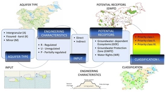
2.5.1. Conceptual Model
The assessment of landfill impacts on groundwater quality status proposed herein is based on a conceptual model of the landfill, which is intended to clearly define the hydrogeologic conditions in the landfill area (
Figure 3). The conceptual model summarizes and evaluates all available data related to the landfill, as well as those obtained during the monitoring period. At the same time, it also identifies the weaknesses and uncertainties related to the available data. In order to carry out an impact assessment, as well as optimize decisions for future pollution management (e.g., monitoring and preventive measures), a conceptual model must answer three specific questions: (1) Do the natural conditions and engineering characteristics of the landfill allow the leaching of pollutants into groundwater; if yes, to what extent, and is the pollutant leaching direct or indirect? (2) Does existing monitoring allow the control of potential pollutant leaching from the landfill area? Is the monitoring network adequate or does it need to be optimized? (3) Is it possible to confirm the environmental impact and estimate its extent?
These questions can be answered if the appropriate information is available, which considers (1) the engineering characteristics of the landfill, including the nature of the pollutants, (2) the natural (e.g., hydrogeological) conditions of the landfill, on the basis of which the risk potential is determined, together with the quantities of leachate and the concentration of the pollutants, (3) possible contamination transport pathways and the presence of indicative contaminants in the groundwater, and (4) potentially affected receptors.
2.5.2. Engineering Characteristics of the Landfill
An important factor for potential groundwater contamination is the engineering characteristics of the landfill, including the landfill liner (lining system), drainage performance and position of drainages, leachate collection, and slope stability. All these conditions are essential to understand potential emissions of pollutant into the environment. For example, if the sealing layer is damaged, direct leaching to groundwater may occur. The quality of the sealing layers and the cover is important to ensure effective cover and to ensure the least possible emissions into surface and groundwater. At least around the landfill body, the natural base of the landfill must be geologically and hydrogeologically uniform and should have proper geological characteristics to ensure protection against contamination of the soil, surface water, and groundwater. The average water permeability of the landfill cover layers must be less than 1 × 10⁻⁹ m/s (Decree on the landfill of waste (Official Gazette of RS, no. 10/14, 54/15, 36/16, 37/18 and 13/21)). If the permeability of the soil is higher, artificial sealing layers (e.g., HDPE foil) are also installed to ensure protection against contamination. The landfill body and its subsoil must be stable in the long term so that possible deformations will not affect the landfill sealing, the leachate and rainwater drainage system, or landfill degassing system. Only constant, unchanged conditions enable controlling the water cycle and the pollutant mass balance, which is the basis for a successful impact and risk assessment.
2.5.3. Hydrogeological Conditions
Karstic/fissured aquifers (
Figure 1) are heterogeneous formations; hence, it is very difficult to predict groundwater hydraulics and mass transport [
33,
34]. Another problem is a significant variability in the discharge behavior of karst water under different hydrologic conditions. In some karst fissures and channels, water can drain very rapidly, while, in others, it can be retained much longer [
35,
36,
37]. The difference in groundwater levels has a significant impact on the direction and the travel time of groundwater, as well as on the possibility of dilution and storage of contaminants in the subsurface. From this perspective, landfill sites on karst aquifers should be treated differently than those on intergranular aquifers. Aquifers with karstic/fissured porosity are very vulnerable. Therefore, new landfills in karstic areas are prohibited in Slovenia. The risks posed by landfills in karstic areas are associated with the heterogeneity of the hydrogeological characteristics, such as highly variable spatial distribution of (1) fractures in the bedrock (2), permeability of aquifer, and (3) groundwater flow velocity and direction. In the region of highly fractured or karstified bedrock and variable (spatially and temporarily) groundwater flow conditions, there is a high risk that pollution from the landfill will spread to a wider area.
The recognition and the evaluation of groundwater flow hydraulic properties in intergranular aquifers (
Figure 1) are relatively straightforward. In such areas, with an appropriate monitoring network and under well-known boundary conditions, the contamination plume downgradient from the landfill and outside of the monitoring network can be followed using analytical methods and simulations. The greatest risk for contamination spreading is posed by surface water, which can drain relatively large quantities (volumes) of groundwater. In porous aquifers, interactions between groundwater and surface water often occur, resulting in the direct impact of contamination on local ecosystems or even on groundwater sources used for the drinking water supply.
The movement of contaminants in groundwater depends on the natural attenuation of the soil and natural degradation processes in the aquifer. Natural attenuation is the result of various physical, chemical, and biological processes and can reduce the mass, toxicity, mobility, volume, or concentrations of soil or groundwater contaminants without human intervention. These processes include biodegradation, dilution, sorption, evaporation, and radioactive decay. Natural attenuation occurs in all contaminated areas, but the rate of the degradation process depends on certain conditions in the soil. If such conditions are not significantly present, contaminant degradation is not effective nor comprehensive [
38,
39].
Determination of hydrogeological parameters (hydraulic conductivity, porosity, etc.) of the aquifer is important for the proper control and prediction of contaminant transport including plume spreading. Here, the nature of contaminant emissions to groundwater is also an important factor. Several conditions can be interpreting regarding the contamination source (landfill body) position and groundwater level. The direct source of contamination is when the landfill body (partially or wholly) is permanently or occasionally in a saturated zone. When the landfill body is permanently in unsaturated zone, this can be interpreted as an indirect contamination source [
40].
2.5.4. Potential Pathway of the Pollution
When considering the contamination pathways in groundwater, it is important to consider the horizontal pathway along the main groundwater flow direction. The groundwater flow regime is a key parameter that allows indicating the relative length of the path of the contaminant, the travel time, and the possible interaction with surface water.
Quality of the monitoring network is a crucial factor to determine the extent of the contamination plume estimation and, consequently, of the risk assessment. A proper monitoring network enables an early warning system and long-term forecast. It includes several observation points along the groundwater flow path. A monitoring site upgradient from the landfill can be used to determine potential changes in natural background levels and to define the extent of the impact. Analysis of leachate represents the range and mass of pollutants at the emission point (point of compliance POC 0). The monitoring site below the landfill (POC 1) in the contaminant plume at the entrance to the groundwater is the key monitoring point, revealing the pressure of the landfill to groundwater. POC 2 is the early warning monitoring site downstream between the landfill and the monitoring site POC 3 at the receptor (spring, well, etc.) [
41].
2.5.5. Potential Receptors Affected by the Pollution
Evaluation of the actual landfill impact is based on the determination of potential receptors and their position. In this study, the receptors are presented as sensitive areas on which the potential contamination spreading from landfill may have a strong impact. Such areas are the water protection zones of drinking water and areas with the presence of the groundwater-dependent ecosystems.
Groundwater protection zones are delimited according to the methodology provided in national regulations (Rules on criteria for the designation of a water protection zone (Official Gazette RS, no. 64/04, 5/06, 58/11 and 15/16)). The purpose of groundwater protection zones is to prevent and restrict points and diffuse sources of pollution that may affect drinking water quality [
42]. Protective measures, prohibitions, and restrictions apply to construction and other land uses. In Slovenia, approximately 17% of the territory is under a water protection zone regime [
43].
As an integral part of the groundwater body status assessment in Slovenia, areas with groundwater-dependent ecosystems (GDEs) have been identified on the basis of hydrological and hydrogeological conditions within the territory of Slovenia. GDEs include ecosystems in groundwater, terrestrial ecosystems dependent on groundwater, and aquatic ecosystems in surface waters dependent on groundwater [
44,
45]. They require constant or occasional contact with groundwater to sustain communities of diverse animal and plant species, ecological processes, and ecosystem services [
45]. Consequently, they are a good indicator of the status of groundwater bodies and play an important role in their assessment [
46,
47]. In total, GDEs cover about 28% of the Slovenian territory.
2.6. Synoptic Risk Assessment
The methodology for classifying landfills into priority classes was developed according to the criteria of individual components of the conceptual model and the chemical characteristics of groundwater (
Table 3). According to the presented criteria, we made a decision tree for each type of aquifer (intergranular aquifers, fissured/karstic aquifers, and minor aquifers of porous or fissured porosity and formations without significant groundwater resources), on the basis of which we classified the landfill into an individual priority class, as shown in the
Supplementary Material S2.
Classification of landfills was based on the assumption of setting priorities of protection against impacts on groundwater quality. In terms of the groundwater risk pollution, landfills were classified into three priority classes: (1) landfills with a significant impact on local groundwater quality and a potential impact on quality of the groundwater body. These are landfills where contamination may spread with groundwater to the wider area, posing a risk to potential drinking water supplies and/or groundwater-dependent ecosystems downgradient from the landfill site; (2) landfills with less significant impacts on groundwater, either due to favorable natural attenuation processes or due to adequate engineering performance of the landfill itself. These are landfills where the natural attenuation of the subsurface is assumed to be sufficiently efficient to prevent the spread of contaminants with groundwater flow. Impact on groundwater quality is limited to the local area of the landfill; (3) landfills with insignificant impact or no impact on groundwater quality. These landfills and their impact areas are located in the areas of limited groundwater resources or even in the areas without groundwater. Pollutants from the landfill cannot be spread by groundwater flow. There is no risk to groundwater resources or to groundwater-dependent ecosystems.
3. Results and Discussion
3.1. Indicative Parameters of Impacts on Groundwater
Indicative parameters for 68 landfills were determined through the data processing presented in
Section 2.4.3. According to this analysis, the indicative parameters indicating the impact of the landfill on groundwater quality status (calculated values ≥100%) were determined for each landfill, (
Figure 1).
Those parameters that occur in at least 10% (±1%) of all landfills were included in further analysis. We identified 43 indicative parameters, which were classified into three groups, namely, major parameters, microelements, and organic compounds. We assigned the number of landfills according to type of landfill to each identified indicative parameter. The classification is shown in
Figure 4 and
Table 3.
Figure 4 shows the frequencies of the indicative parameters indicating the impact of the landfill on groundwater quality. The highest frequency was obtained for boron (47) under the group of microelements, followed by major parameters K
+, Na
+, Cl
−, SO
42−, NH
4+, and NO
3− (46–31), and some organic compounds TOC (36) and AOX (32). Most of the microelements were determined as indicative parameters from 19 to 31 times. Among them, Mn corresponded with 41 determinations and Fe corresponded with 32 determinations. However, some of them were also detected in smaller frequencies (7–17 times). Organic compounds were represented by seven parameters in frequencies ranging from 13 to 18 instances. In this group, we most frequently recognized total pesticides.
We performed a detailed analysis by individual group of parameters and type of landfill.
Table 4 shows the frequencies of determination of indicative parameters by group of parameters and type of landfills.
K
+, Cl
−, TOC, and Na
+ were recognized as the most indicative parameters under the group major parameters and organic compounds in the municipal landfills group, as they, among other major ions, control the mineralization processes in the landfill body and can occur in different compound combinations as of geogenic (natural) origin or as a result of leaching from landfilled waste materials (of anthropogenic origin). Among them, NO
3−, NO
2−, and NH
4+ were also frequently recognized as indicative parameters in the literature [
8].
In the group of microelements, Fe and Mn were typically determined as indicative parameters as expected [
8,
24], since both occur in areas where the reduction conditions downstream of the landfill are significant [
3]. The metals B, Co, and Ni were also detected at more than 50% of the landfills, as expected [
48]. Organic compounds were detected as typical contaminants in municipal landfills. Prometryne was most frequently detected as an indicative parameter, followed by pesticides (total) MCPP, bentazone, and DEET. Atrazine and BPA were less frequently determined. The presence of pesticides in groundwater at landfill sites is a complex issue owing to the possibility that these substances may be present simultaneously and may originate from different sources. Pesticides were already present in groundwater at the upstream sampling point as the result of their use on agricultural land. However, the groundwater in the landfill area was additionally loaded with pesticides due to the deposited landfill waste, as evidenced by the higher concentrations of pesticides in groundwater at downstream sampling points (
Supplementary Material S1 (sheet “Main parameters at each landfill”)).
Na+, K+, and SO42− were identified as indicative parameters from the group major ions in the groups inert and nonhazardous landfills with fewer instances. Among microelements, Mn and B were identified as indicative parameters in more than 50% of the landfills in both groups. Inert landfills were also characterized by Mo (most frequent, 5/7) and Cr (3/7), while nonhazardous landfills were characterized by As (most frequent, 8/10) and Ba, as well as Cl− and NH4+. Inert landfills mostly constituted fly ash, slag, and construction waste from which nonhazardous inorganic compounds (sulfate and sodium) and metals were leached. Organic compounds were detected individually, and usually in a single instance.
Na+, K+, Cl−, and B were identified as indicative parameters at two hazardous landfills.
3.2. Synoptic Risk Assessment
A total of 24 landfills that had a significantly pronounced impact on groundwater and could also be reflected in the chemical status of the groundwater body were classified as Priority Class 1. Among those, eight landfills were located in the area of aquifers where intergranular porosity (type I.a and I.b) was predominant, eight landfills were located in aquifers with predominantly karstic/fissured porosity (type II.a and II.b), and eight landfills were located in the area of minor aquifers with local and limited groundwater sources (III.a). All landfills located directly in a groundwater protection zone, where direct inflow and rapid transport of pollutants were identified, and which were also engineering unregulated, were classified as Class 1. For most of these landfills, the impact on groundwater was clear. In addition, landfills were included in Priority Class 1, where the waste is deposited directly in an abandoned gravel pit without sealing and under unfavorable hydrogeological conditions (highly permeable aquifer and high groundwater flow velocity).
A total of 31 landfills with less significant impacts were classified with Priority Class 2 due to favorable natural attenuation below the landfill or landfills with suitable engineering characteristics. Of these, 11 landfills were located in the vicinity of aquifers dominated by intergranular porosity (types I.a and I.b), eight landfills were located in the area of aquifers dominated by karstic/fissured porosity (type II.a and II.b), and 10 landfills were located in the area of minor aquifers with local and limited groundwater resources (III.a). Two landfills were located in the area of poorly permeable roof layers (type III.c).
Class 2 also included landfills where the impact of the landfill was not as significant due to groundwater pressures in the affected aquifer, but which were located in groundwater protection zones. Class 2 also included landfills that, owing to their engineering characteristics or the prevailing natural conditions, allowed significant inputs of pollutants into the groundwater. The contamination plume was also not expected to affect the wider environment.
Landfills located in areas of karstic/fissured porosity were considered separately due to uncertainty in determining the groundwater flow direction and its velocity. An additional issue was the distance between monitoring points, which, in most cases, was greater than 10 km. At these distances, there were known and unknown surface sources that may have a greater impact on groundwater status than the landfill; therefore, it was not possible to reliably assess the potential impact of the landfill on the status of the groundwater body.
A total of 14 landfills with little or no impact on groundwater quality were included in Priority Class 3. Most of the landfills (seven) were on aquifers dominated by karstic/fissured porosity, four landfills were on aquifers dominated by intergranular porosity, and three were located on minor aquifers with local and limited groundwater resources. The main criteria for the classification of these landfills were as follows: the landfill was small to medium-sized, where large amounts of leachate were not expected, and the engineering characteristics of the landfill were at least partially regulated. This class also included landfills where expected groundwater pressures were low or absent, and the natural conditions were sufficiently good, as well as if the contamination plume could be followed through monitoring to predict the spatial and temporal distribution of contaminants.
4. Conclusions
This study presented a developed method of synoptic risk assessment based on a conceptual model of the landfill and the results of the groundwater chemical monitoring, which was tested on 69 landfills in Slovenia.
The study confirmed that majority of landfills in Slovenia can affect groundwater quality. On average, these impacts are small to negligible; however, in some cases, they can be significant and can also affect the quality of the groundwater body.
Analysis of chemical groundwater monitoring showed that B is the most often determined indicative parameter in groundwater, followed by Mn-total, Fe-total, K+, Na+, Cl−, and SO42−. The least frequently detected indicative parameters appeared in the group organic compounds, with the most frequently detected TOC and AOX.
Landfills differed significantly depending on the wastes they receive. For inert landfills, Mo occurred as an indicative parameter in more than 70% of cases, while As was most frequently detected in non-hazardous landfills. F−, Mg2+, and NO3− were only determined at a frequency rate of more than 50% in non-hazardous landfills, while AOX, TOC, Co, Fe-total, and Ni were only present at more than 50% in the municipal landfills. As expected, organic compounds were identified as typical contaminants mainly in municipal landfills.
The landfill classification used showed that a total of 24 landfills had a significantly pronounced impact on groundwater and may also be reflected in the chemical status of the groundwater body; accordingly, they were classified in Priority Class 1. These landfills should be given the greatest attention with an emphasis on protection measures. For these landfills, additional engineering measures are required to reduce the input of contaminants more effectively from the landfill into the groundwater.
A total of 31 landfills had less significant impacts due to favorable natural attenuation below the landfill or landfills with suitable engineering characteristics; accordingly, they belonged to Priority Class 2. For these landfills, appropriate measures need to be prepared. The main measure is to ensure reliable monitoring, while no other technical measures are expected except those that are mandatory.
A total of 14 landfills had little or no impact on groundwater quality and, accordingly, were included in Priority Class 3. These landfills are not expected to require additional measures beyond the basic landfill measures in place. There is no risk to groundwater sources or groundwater-dependent ecosystems.
The classification of landfill impacts based on the synoptic risk assessment presented in our study was found to be effective in assessing the environmental impact of landfills, and it can also be used as a guideline in other parts of the world. Annual monitoring enables landfill managers to control the efficiency of the protection measures and improve the program of measures if needed. The survey of monitoring results of all landfills enables permitting and managing authority to improve operational programs and action plans. This relies on a synoptic risk assessment which enables specifying the priorities and milestones of needed actions. As can be seen from the Water Framework Directive, preparation of the program will consider the principles aimed at preventing and limiting the discharge of substances.
Further work will focus on a statistical evaluation of the indicative parameters, as it is necessary to identify concentration trends and work on the possible concentration range of each indicative parameter. This information will be very important to determine whether the situation at individual landfills is deteriorating, improving, or even stagnating. This is also the basis for planning additional protection measures in the future.


