Comparison of Wind Lidar Data and Numerical Simulations of the Low-Level Jet at a Grassland Site


Abstract
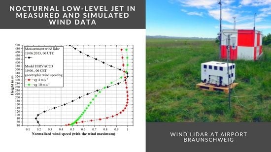
:
1. Introduction
2. Data Sets
2.1. Simulated Data Set: ABL Model HIRVAC2D
2.2. Measured Data Set: Remote Sensing by Wind Lidar
3. Results
3.1. Characterisation of LLJ Properties Based on Wind Lidar Data Set
3.1.1. Diurnal distribution of LLJ
3.1.2. Sensitivity of LLJ Definition to Wind Speed Criteria
3.1.3. LLJ Altitude and Wind Speed
3.2. Comparison of Measured and Simulated Data Set
3.2.1. Development of Single LLJ Events
3.2.2. Properties of LLJ in Measured and Simulated Data
4. Discussion and Conclusions
- the possibility to directly simulate significant processes for the object of investigation,
- the parameterizations in the model,
- the data for the model initialization,
- the data for land use and vegetation parameters,
- the choice of boundary conditions,
- the numerical uncertainty regarding the model-inherent time step and the choice of numerical method.
Author Contributions
Funding
Acknowledgments
Conflicts of Interest
References
- United Bank for Africa. Available online: https://www.umweltbundesamt.de/themen/klima-energie/erneuerbare-energien/-erneuerbare-energien-in-zahlen#statusquo (accessed on 23 August 2020).
- European Commission. Communication from the Commission to the European Parliament, the European Council, the Council, the European Economic and Social Committee and the Committee of the Regions; European Commission: Brussels, Belgium, 2019. [Google Scholar]
- International Renewable Energy Agency. Future of Wind: Deployment, Investment, Technology, Grid Integration and Socio-Economic Aspects (A Global Energy Transformation Paper); International Renewable Energy Agency: Abu Dhabi, UAE, 2019. [Google Scholar]
- Rohrig, K.; Berkhout, V.; Callies, D.; Durstewitz, M.; Faulstich, S.; Hahn, B.; Jung, M.; Pauscher, L.; Seibel, A.; Shan, M.; et al. Powering the 21st century by wind energy—Options, facts, figures. Appl. Phys. Rev. 2019, 6, 031303. [Google Scholar] [CrossRef]
- Karagali, I.; Hahmann, A.N.; Badger, M.; Hasager, C.B.; Mann, J. New European wind atlas offshore. J. Phys. Conf. Ser. 2018, 1037. [Google Scholar] [CrossRef]
- Gottschall, J.; Catalano, E.; Dörenkämper, M.; Witha, B. The NEWA Ferry Lidar Experiment: Measuring Mesoscale Winds in the Southern Baltic Sea. Remote Sens. 2018, 10, 1620. [Google Scholar] [CrossRef] [Green Version]
- Baas, P.; Bosveld, F.C.; Klein Baltink, H.; Holtslag, A.A.M. A Climatology of Nocturnal Low-Level Jets at Cabauw. J. Appl. Meteorol. Climatol. 2009, 48, 1627–1642. [Google Scholar] [CrossRef]
- Gross, G. Numerical simulation of future low-level jet characteristics. Meteorol. Z. 2012, 21, 305–311. [Google Scholar] [CrossRef]
- Blackadar, A.K. Boundary layer wind maxima and their significance for the growth of nocturnal inversions. Bull. Am. Meteorol. Soc. 1957, 38, 283–290. [Google Scholar] [CrossRef] [Green Version]
- Shapiro, A.; Fedorovich, E. Analytical description of a nocturnal low-level jet. Q. J. R. Meteorol. Soc. 2010, 136, 1255–1262. [Google Scholar] [CrossRef]
- Lampert, A.; Jimenez, B.B.; Gross, G.; Wulff, D.; Kenull, T. One-year observations of the wind distribution and low-level jet occurrence at Braunschweig, North German Plain. Wind Energy 2016, 19, 1807–1817. [Google Scholar] [CrossRef]
- Marke, T.; Crewell, S.; Schemann, V.; Schween, J.H.; Tuononen, M. Long-Term Observations and High-Resolution Modeling of Midlatitude Nocturnal Boundary Layer Processes Connected to Low-Level Jets. J. Appl. Meteorol. Climatol. 2018, 57, 1155–1170. [Google Scholar] [CrossRef]
- Mirocha, J.D.; Simpson, M.D.; Fast, J.D.; Berg, L.K.; Baskett, R.L. Investigation of boundary-layer wind predictions during nocturnal low-level jet events using the Weather Research and Forecasting model. Wind Energy 2016, 19, 739–762. [Google Scholar] [CrossRef]
- Porté-Agel, F.; Bastankhah, M.; Shamsoddin, S. Wind-Turbine and Wind-Farm Flows: A Review. Bound.-Layer Meteorol. 2020, 174. [Google Scholar] [CrossRef]
- Fitch, A.C.; Lundquist, J.K.; Olson, J.B. Mesoscale Influences of Wind Farms throughout a Diurnal Cycle. Mon. Weather Rev. 2013, 141, 2173–2198. [Google Scholar] [CrossRef]
- Abkar, M.; Sharifi, A.; Porté-Agel, F. Wake flow in a wind farm during a diurnal cycle. J. Turbul. 2016, 17, 420–441. [Google Scholar] [CrossRef]
- Sharma, V.; Parlange, M.B.; Calaf, M. Perturbations to the Spatial and Temporal Characteristics of the Diurnally-Varying Atmospheric Boundary Layer Due to an Extensive Wind Farm. Bound.-Layer Meteorol. 2017, 162, 255–282. [Google Scholar] [CrossRef] [Green Version]
- Gutierrez, W.; Araya, G.; Kiliyanpilakkil, P.; Ruiz-Columbie, A.; Tutkun, M.; Castillo, L. Structural impact assessment of low level jets over wind turbines. J. Renew. Sustain. Energy 2016, 8, 023308. [Google Scholar] [CrossRef]
- Doosttalab, A.; Siguenza-Alvarado, D.; Pulletikurthi, V.; Jin, Y.; Bocanegra Evans, H.; Chamorro, L.P.; Castillo, L. Interaction of low-level jets with wind turbines: On the basic mechanisms for enhanced performance. J. Renew. Sustain. Energy 2020, 12, 053301. [Google Scholar] [CrossRef]
- Veers, P.; Dykes, K.; Lantz, E.; Barth, S.; Bottasso, C.L.; Carlson, O.; Clifton, A.; Green, J.; Green, P.; Holttinen, H.; et al. Grand challenges in the science of wind energy. Science 2019. [Google Scholar] [CrossRef] [Green Version]
- Du, Y.; Rotunno, R. A Simple Analytical Model of the Nocturnal Low-Level Jet over the Great Plains of the United States. J. Atmos. Sci. 2014, 71, 3674–3683. [Google Scholar] [CrossRef]
- Van de Wiel, B.J.H.; Moene, A.F.; Steeneveld, G.J.; Baas, P.; Bosveld, F.C.; Holtslag, A.A.M. A Conceptual View on Inertial Oscillations and Nocturnal Low-Level Jets. J. Atmos. Sci. 2010, 67, 2679–2689. [Google Scholar] [CrossRef] [Green Version]
- Baas, P.; Bosveld, F.C.; Lenderink, G.; van Meijgaard, E.; Holtslag, A.A.M. How to design single-column model experiments for comparison with observed nocturnal low-level jets. Q. J. R. Meteorol. Soc. 2010, 136, 671–684. [Google Scholar] [CrossRef]
- Storm, B.; Dudhia, J.; Basu, S.; Swift, A.; Giammanco, I. Evaluation of the Weather Research and Forecasting model on forecasting low-level jets: Implications for wind energy. Wind Energy 2009, 12, 81–90. [Google Scholar] [CrossRef]
- Steeneveld, G.J.; Mauritsen, T.; de Bruijn, E.I.F.; Vilà-Guerau de Arellano, J.; Svensson, G.; Holtslag, A.A.M. Evaluation of Limited-Area Models for the Representation of the Diurnal Cycle and Contrasting Nights in CASES-99. J. Appl. Meteorol. Climatol. 2008, 47, 869–887. [Google Scholar] [CrossRef]
- Sommerfeld, M.; Crawford, C.; Monahan, A.; Bastigkeit, I. LiDAR-based characterization of mid-altitude wind conditions for airborne wind energy systems. Wind Energy 2019, 22, 1101–1120. [Google Scholar] [CrossRef]
- Mix, W.; Goldberg, V.; Bernhardt, K.-H. Numerical experiments with different approaches for boundary layer modeling under large-area forest canopy conditions. Meteorol. Z. 1994, 187–192. [Google Scholar] [CrossRef]
- Ziemann, A. Numerical simulation of meteorological quantities in and above forest canopies. Meteorol. Z. 1998, 120–128. [Google Scholar] [CrossRef]
- Queck, R.; Bernhofer, C.; Bienert, A.; Eipper, T.; Goldberg, V.; Harmansa, S.; Hildebrand, V.; Maas, H.-G.; Schlegel, F.; Stiller, J. TurbEFA: An interdisciplinary effort to investigate the turbulent flow across a forest clearing. Meteorol. Z. 2015, 637–659. [Google Scholar] [CrossRef]
- Ivanell, S.; Arnqvist, J.; Avila, M.; Cavar, D.; Chavez-Arroyo, R.A.; Olivares-Espinosa, H.; Peralta, C.; Adib, J.; Witha, B. Micro-Scale Model Comparison (Benchmark) at the Moderately Complex Forested Site Ryningsnäs. Wind Energy Sci. 2018, 3, 929–946. [Google Scholar] [CrossRef] [Green Version]
- Ziemann, A.; Starke, M.; Leiding, T. Sensitivity of nocturnal low-level jets to land-use parameters and meteorological quantities. Adv. Sci. Res. 2019, 16, 85–93. [Google Scholar] [CrossRef]
- Banta, R.M.; Newsom, R.K.; Lundquist, J.K.; Pichugina, Y.L.; Coulter, R.L.; Mahrt, L. Nocturnal Low-Level Jet Characteristics Over Kansas During Cases-99. Bound.-Layer Meteorol. 2002, 105, 221–252. [Google Scholar] [CrossRef]
- Rausch, T.; Schuchard, M.; Lampert, A. One year Measurements of Vertical Profiles of Wind Speed and Wind Direction from 40 to 500 m at Braunschweig; North German Plain: Cologne, Germany, 2020. [Google Scholar]
- Rausch, T.; Canadillas, C.; Siedersleben, S.; Degenhardt, J.; Simsek, T.; Batuhan Tayfun, Y.; Hampel, O.; Asmussen, M.; Teichert, D.; Neumann, T.; et al. Low-Level Jets in Coastal Areas of the German Bight. Wind Energy Sci. 2020, 20, 1985–2000. [Google Scholar]
- Sogachev, A.; Panferov, O. Modification of Two-Equation Models to Account for Plant Drag. Bound.-Layer Meteorol. 2006, 121, 229–266. [Google Scholar] [CrossRef]
- Sogachev, A. A Note on Two-Equation Closure Modelling of Canopy Flow. Bound.-Layer Meteorol. 2009, 130, 423–435. [Google Scholar] [CrossRef]
- Smith, D.A.; Harris, M.; Coffey, A.S.; Mikkelsen, T.; Jørgensen, H.E.; Mann, J.; Danielian, R. Wind lidar evaluation at the Danish wind test site in Høvsøre. Wind Energy 2006, 9, 87–93. [Google Scholar] [CrossRef]
- Song, J.; Liao, K.; Coulter, R.L.; Lesht, B.M. Climatology of the low-level jet at the southern Great Plains atmospheric boundary layer experiments site. J. Appl. Meteorol. 2005, 44, 1593–1606. [Google Scholar] [CrossRef]
- Reuder, J.; Brisset, P.; Jonassen, M.M.; Mayer, S. The Small Unmanned Meteorological Observer SUMO: A new tool for atmospheric boundary layer research. Meteorol. Z. 2009, 141–147. [Google Scholar] [CrossRef]
- Platis, A.; Altstädter, B.; Wehner, B.; Wildmann, N.; Lampert, A.; Hermann, M.; Birmili, W.; Bange, J. An Observational Case Study on the Influence of Atmospheric Boundary-Layer Dynamics on New Particle Formation. Bound.-Layer Meteorol. 2016, 158, 67–92. [Google Scholar] [CrossRef]
- Lampert, A.; Altstädter, B.; Bärfuss, K.; Bretschneider, L.; Sandgaard, J.; Michaelis, J.; Lobitz, L.; Asmussen, M.; Damm, E.; Käthner, R.; et al. Unmanned Aerial Systems for Investigating the Polar Atmospheric Boundary Layer—Technical Challenges and Examples of Applications. Atmosphere 2020, 11, 416. [Google Scholar] [CrossRef] [Green Version]
- Wagner, R.; Courtney, M.; Gottschall, J.; Lindelöw-Marsden, P. Accounting for the speed shear in wind turbine power performance measurement. Wind Energy 2011, 14, 993–1004. [Google Scholar] [CrossRef] [Green Version]
- Negash, T.; Möllerström, E.; Ottermo, F. An Assessment of Wind Energy Potential for the Three Topographic Regions of Eritrea. Energies 2020, 13, 1846. [Google Scholar] [CrossRef]


| Vegetation | Height in m | PAI | Vegetation Cover |
|---|---|---|---|
| Grassland | 0.1 | 3 and 1 | 0.9 and 0.5 |
| Deciduous forest | 15 or 28 | 5.2 or 6.0 | 0.9 |
| Coniferous forest | 37 | 9.4 | 0.9 |
Publisher’s Note: MDPI stays neutral with regard to jurisdictional claims in published maps and institutional affiliations. |
© 2020 by the authors. Licensee MDPI, Basel, Switzerland. This article is an open access article distributed under the terms and conditions of the Creative Commons Attribution (CC BY) license (http://creativecommons.org/licenses/by/4.0/).
Share and Cite
Ziemann, A.; Galvez Arboleda, A.; Lampert, A. Comparison of Wind Lidar Data and Numerical Simulations of the Low-Level Jet at a Grassland Site. Energies 2020, 13, 6264. https://doi.org/10.3390/en13236264
Ziemann A, Galvez Arboleda A, Lampert A. Comparison of Wind Lidar Data and Numerical Simulations of the Low-Level Jet at a Grassland Site. Energies. 2020; 13(23):6264. https://doi.org/10.3390/en13236264
Chicago/Turabian StyleZiemann, Astrid, André Galvez Arboleda, and Astrid Lampert. 2020. "Comparison of Wind Lidar Data and Numerical Simulations of the Low-Level Jet at a Grassland Site" Energies 13, no. 23: 6264. https://doi.org/10.3390/en13236264