Article

Using Aerial Thermal Imagery to Evaluate Water Status in Vitis vinifera cv. Loureiro

by
Cláudio Araújo-Paredes
1,*,
Fernando Portela
2,
Susana Mendes
3 and
M. Isabel Valín
3
1
PROMETHEUS, Research Unit in Materials, Energy and Environment for Sustainability, Escola Superior Agrária, Instituto Politécnico de Viana do Castelo, Rua Escola Industrial e Comercial de Nun’Álvares, 4900-347 Viana do Castelo, Portugal
2
Escola Superior Agrária, Instituto Politécnico de Viana do Castelo, 4900-347 Viana do Castelo, Portugal
3
Centre for Research and Development in Agrifood Systems and Sustainability, Escola Superior Agrária, Instituto Politécnico de Viana do Castelo, 4900-347 Viana do Castelo, Portugal
*
Author to whom correspondence should be addressed.
Sensors 2022, 22(20), 8056; https://doi.org/10.3390/s22208056
Submission received: 12 September 2022 / Revised: 14 October 2022 / Accepted: 18 October 2022 / Published: 21 October 2022

Abstract

:
The crop water stress index (CWSI) is a widely used analytical tool based on portable thermography. This method can be useful in replacing the traditional stem water potential method obtained with a Scholander chamber (PMS Model 600) because the latter is not feasible for large-scale studies due to the time involved and the fact that it is invasive and can cause damage to the plant. The present work had three objectives: (i) to understand if CWSI estimated using an aerial sensor can estimate the water status of the plant; (ii) to compare CWSI from aerial-thermographic and portable thermal cameras with stem water potential; (iii) to estimate the capacity of an unmanned aerial vehicle (UAV) to calculate and spatialize CWSI. Monitoring of CWSI (CWSIP) using a portable device was performed directly in the canopy, by measuring reference temperatures (Tdry, Twet, and canopy temperature (Tc)). Aerial CWSI calculation was performed using two models: (i) a simplified CWSI model (CWSIS), where the Tdry and Twet were estimated as the average of 1% of the extreme temperature, and (ii) an air temperature model (CWSITair) where air temperatures (Tair + 7 °C) were recorded as Tdry and in the Twet, considering the average of the lowest 33% of histogram values. In these two models, the Tc value corresponded to the temperature value in each pixel of the aerial thermal image. The results show that it was possible to estimate CWSI by calculating canopy temperatures and spatializing CWSI using aerial thermography. Of the two models, it was found that for CWSITair, CWSIS (R2 = 0.55) evaluated crop water stress better than stem water potential. The CWSIS had good correlation compared with the portable sensor (R2 = 0.58), and its application in field measurements is possible.

1. Introduction

In recent years, increased frequency of extremely high temperatures and low rainfall [1], together with the intensification of agricultural practices, has required that more attention be paid to the use of natural resources [2]. According to the most unfavorable scenario forecast by the Intergovernmental Panel Climate Change (IPCC) related to the representative concentration pathway (RCP) 8.5, water availability will decrease throughout the north of Portugal, and approximately 20% of the Vinho Verde Region, accompanied by a gradual increase in temperature [3]. In this scenario, grape quality and wine production [4,5] and the overall cycle of vines [6,7] will be affected by low soil water availability [3,5,6]. Strategies to achieve the full potential of a vineyard should include frequent monitoring of vine water status [7] and estimates of cultural evapotranspiration [8,9,10,11] to adopt the best irrigation practices.
It was shown in previous studies that several crop-based indices such as canopy temperature [12,13,14,15,16,17,18,19], chlorophyll content [20,21,22], and vegetation indices [23,24,25,26,27,28], can be used to determine crop water content, and have been employed for managing water in irrigated agriculture [29,30,31,32,33]. Canopy temperature [34] thermal indices obtained with ground-based or aerial-based sensors, can indicate crop transpiration and water stress, allowing the development of indices that assess vine water status [13,35] in a non-destructive and non-invasive way [18,36].
Unmanned aerial vehicles (UAVs), and thermal sensors coupled to UAVs, have been tested in precision viticulture [37,38] and offer advantages over measurements with ground-based (portable) sensors [13,35,39,40], due to their performance, flexibility of use, low operating cost, and very high spatial resolution [41,42]. Characterization of the spatial variability of crop water requirements is a prerequisite to apply precision scheduling strategies within orchards, and to enhance efficient water utilization to maintain vineyard yields and grape quality [36,37,43,44,45]. The development of models to spatialize data [18,42,46,47], converting localized information to continuous information, has changed the manner of observations from horizontal to vertical.
One of the most used thermal indices is the Crop Water Stress Index (CWSI), which varies between 0 (no stress) and 1 (maximum stress). Initially developed by [12], and later by [13], CWSI is based on a linear relationship between the difference in canopy temperature (Tc), air temperature, and baseline parameters such as dry leaf temperature (Tdry), and wet leaf temperature (Twet) [13,35]. The CWSI method has been widely used in irrigated crops, and is considered a standard method. Many studies have been carried out in different crops, including nectarines [17,19], soybean [48], cotton [49], tomato [50], olive trees [51] and vines [52,53,54].
Methods have been developed methods to obtain Tdry and Twet from aerial thermal images for calculating the CWSI. Of these, the methods that extract temperatures from the image histogram stand out because they simplify and streamline the process of obtaining data [49,55,56]. Using probability models to calculate the two temperatures (Tdry and Twet) for nectarines, [17] it was found that the temperature distribution can vary between different varieties and on the distribution of trees, even under similar irrigation levels. In cotton, extremes values of the surface temperature histogram were extracted to determine Twet and Tdry, demonstrating that the method was feasible to estimate the water status [49]. In vineyards, thermal imaging has shown that it can estimate water status accurately, with continuous representation, by the spatialization of data [18].
These methods have used a statistical approach to simplify the calculation of Tdry and Twet, taking these values as averages from the extremes values of the histogram [56,57]. The methods generally estimate better Twet and Tdry values from the average temperatures of the lowest (coldest) and highest (hottest) part of the canopy temperature histogram than critical temperature values [49]. However, in non-continuous crops, such as vines, problems with the methods are increased because crop cover is not homogeneous (vineyard and soil), making it difficult to extract pure pixel values from the canopy, resulting in a bimodal histogram [58], which makes index spatialization difficult.
The present work aimed to evaluate the feasibility of using aerial thermal images to assess vine water status from CWSI spatialization in Vitis vinifera cv. Loureiro. Simplified CWSI (CWSIS) and CWSI air temperature (CWSITair), were used to compare data spatialization and to develop a structural flowchart. Model validation was attempted and analyses conducted concerning the variability of stem water potential Ψst (MPa) and CWSIP (CWSI portable).

2. Materials and Methods

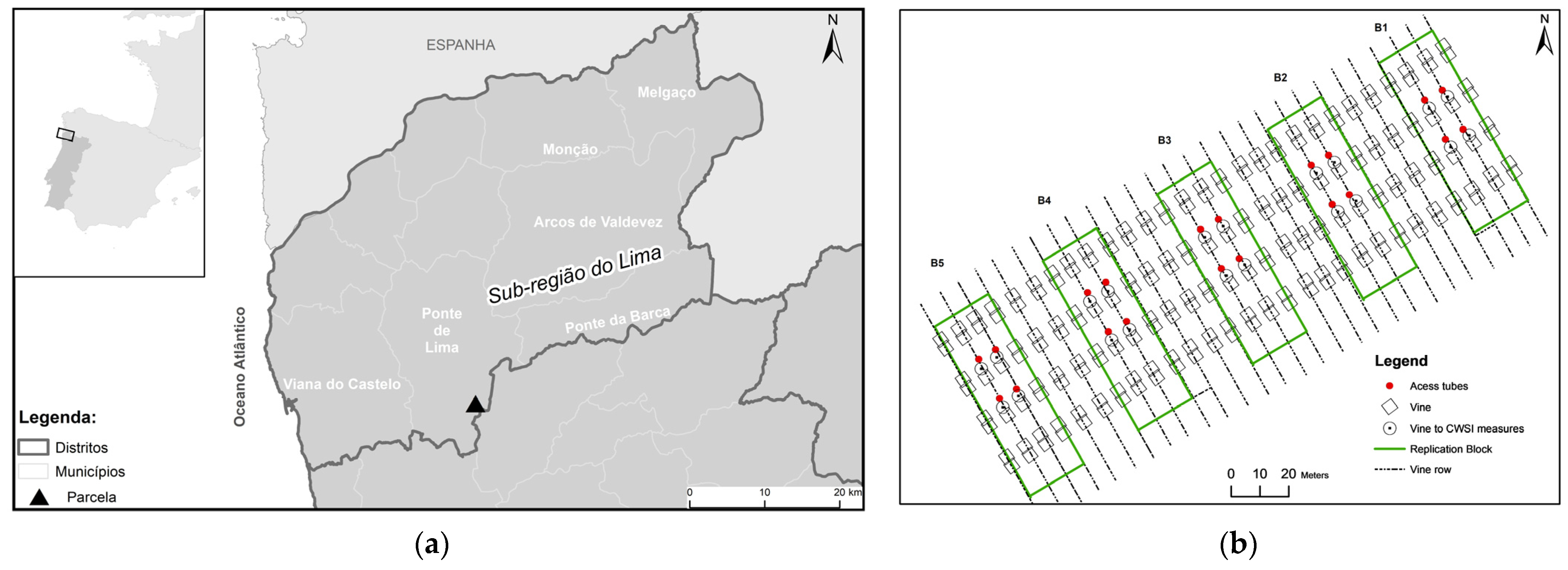
2.1. Study Area and Experimental Design

This work was carried out in 2021 in a commercial vineyard of cv. Loureiro of 5.5 ha in the Vinhos Verdes Region in the northwest of Portugal (41°40′32.2″ N; 8°32′05.9″ W; 175 elevation) (Figure 1a). The climate, characterized as Csb according to the Köppen–Geiger classification [59], has an Atlantic influence with moderate temperatures and thermal amplitudes and high rainfall (1200–1500 mm) concentrated in the winter months. The soil has a loamy texture (50% sand, 31% silt and 19% clay), an average depth of 1 m, organic matter content of 2.65% and a pH of 5.4. The soil water characteristics, obtained by laboratory methods, are a field capacity of 0.231 m3·m−3 (pF 2; 10 kPa) and a wilting coefficient of 0.121 m3·m−3 (pF 4.2; 1.55 MPa).
The vineyard was planted in 2001 in a north-south orientation, 1103 p rootstock, with 3.0 m between rows, and 2.0 m between vines (1666 plant/ha) trained to a single upward cordon. It has a drip irrigation system with one lateral per row (self-compensating drippers with 4 L h−1 flow rate).
The experimental design consisted of five blocks (B1, B2, B3, B4 and B5) of four rows of seven vines each measuring 1500 m2 located 50 m from the beginning of a row (Figure 1b). Only the vines of the two central lines were monitored, and this was conducted on three days of the year (DOY), i.e., day 182 (1 July), day 190 (9 July) and day 194 (13 July) for the following parameters: (i) soil water content (mm) using a capacitive probe (diviner); (ii) midday stem water potential (MPa) in four vines per block using a Scholander pressure chamber; (iii) the temperature of the canopy, using a portable thermal camera (FLIR e75, USA) in each of the 20 vines, on the three data recording dates for a total sample of 60 vines; and (iv) the temperature of the canopy using an aerial thermal camera (Zenmuse XT2, USA) supported by a UAV, (DJI Matrice 210, Frankfurt, Germany).

2.2. UAV Platform, Thermal Camera and Data Acquisition

The aerial images were collected using a DJI UAV, model Matrice 210, coupled with an aerial thermal camera [60,61] (Zenmuse XT2), with an 8 mm lens, resolution 640 × 512 pixels, frequency of 30 Hz, spectral range of 7.5–13.5 µm and a temperature range from −40 to 550 °C. The portable thermal camera (FLIR, e75) had a 17 mm lens, a resolution of 320 × 240 pixels, frequency of 30 Hz, spectral range of 7.5–14 µm and a temperature range from −20 to 120 °C. Sensors were used simultaneously. The images were taken at noon at the sampling site, and each pixel represented temperature in degrees Celsius. In the portable thermal camera, images were taken two meters from the canopy and perpendicular to the direction of the line. Aerial images were taken at a height of 60 m from groundwater potential, with a longitudinal and lateral overlap of 90% to obtain a photogrammetric mosaic (Figure 2). All images were acquired on clear days with minimal wind, and were evaluated on site. In the same location, a PMS Model 600 pressure camera was used to monitor stem water potential, because this is a sensitive indicator for vine water status and is frequently monitored to drive irrigation management.

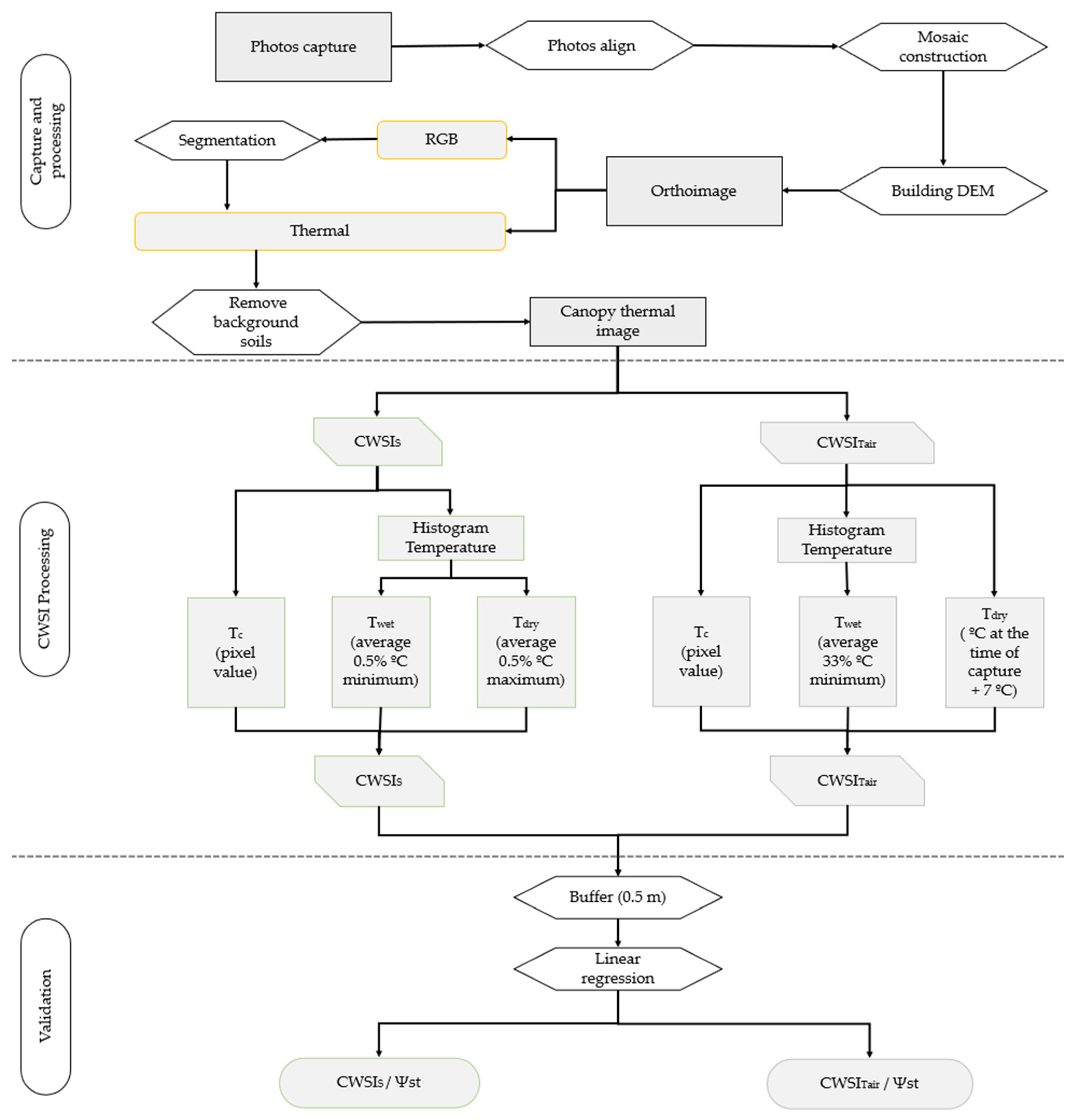
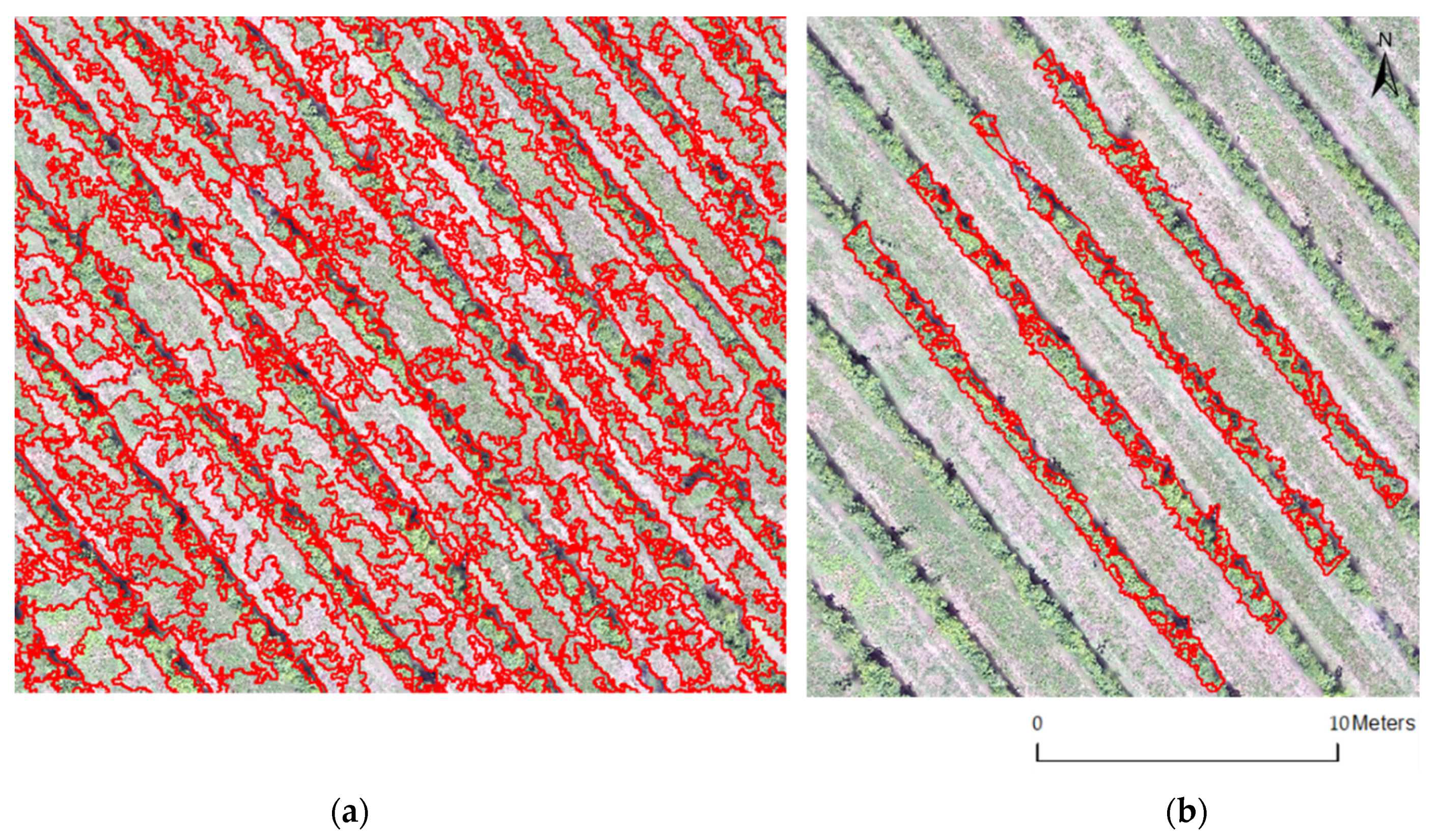
2.3. Image Processing

Aerial thermal images analysed by Agisoft Metashape professional, Version 1.6.3 software to produce final orthophotos with a spatial resolution of 7 cm. To compare temperatures, the portable thermal camera was used to take images at the same time. Temperature calibration parameters such as emissivity, distance to a target, reflectivity temperature and relative humidity were entered into the Flir Tools, Version 5.13.18031.2002 software [62]. Production of the thermal and RGB orthophotography of the work area was carried out in eight main phases according to the flow diagram shown in Figure 2. To support georeferencing and geometric correction of the aerial image, a set of 16 points was assigned as control with a Root Mean Square Error (RMSE) less than 0.5. It was necessary to build a dense cloud of points by which, through photogrammetric restitution, it was possible to derive an extensive set of points that had information regarding an image’s latitude, longitude and altitude.
With this base, the texture of the image and the construction of a Digital Elevation Model (DEM) provided visual improvement and orthophotography production, by orthorectification, of the photogrammetric mosaic previously produced (Figure 2).
In the final phase, segmentation of the RGB aerial image was carried out using IDRISI software. The objective was to differentiate and isolate the areas between the rows, which were occupied by herbaceous vegetation, from areas occupied by vines so that they could be processed separately. Soil area extraction was necessary for the CWSI calculation to be carried out only within the vineyard area. For this procedure, and to delimit the segmentation polygons, a similarity of about 40% between the pixels was considered for analysis (Figure 2).

2.4. Calculation of Portable and Aerial CWSI

The calculation of the CWSI was based on the equation proposed by [13] and modified by [35] (Equation (1):
CWSI = T c T wet T dry T wet
where Tc is the canopy temperature obtained from the thermal image, and Tdry and Twet are the reference temperatures (°C).
For the portable CWSI (CWSIP) the average Tc and average Twet and Tdry were calculated using Flir Tools software. The reference temperatures (Twet and Tdry; °C) were obtained by selecting two healthy leaves close to each other in the canopy. Vaseline was applied to both sides of the Tdry leaf for 30 min before taking the readings to force the stomata to close, thereby preventing evapotranspiration, leading to a consequent increase in leaf temperature. For Twet, the leaf was sprayed with water, two minutes before taking readings to simulate maximum evapotranspiration rate [13,35].
CWSI obtained from the aerial thermal sensor was processed by two methods. The first was CWSIS based on the equation. The reference temperatures were obtained from the image histogram (Figure 3b), in which 99% of the values were assumed to correspond to normal temperatures and the remaining 1% to represent extremes, as discussed by [49], assuming that the Tdry represented the maximum temperature and Twet the minimum temperature [49].
The air temperature method (CWSITair) was also based on Equation (1) but differed in the method for obtaining temperatures. Tc was the value of each pixel of the canopy temperature, Twet was calculated from the average of 33% of the minimum temperatures within the histogram (Figure 3b), and Tdry was obtained from the air temperature plus 7 °C [55,63,64,65] (Figure 2).

2.5. Soil Water Content

The water content in the soil (φ) was measured at different depths (from 10 to 80 cm) by a capacitive probe to determine if soil water availability influenced the water status of the crop.

2.6. CWSI Validation with Stem Water Potential

To analyze the ability of the aerial CWSI to estimate the water status of the vine, coefficients of determination (R2) were calculated for each DOY and the data from the different CWSI (portable, simplified and air temperature), stem water potential (MPa) and CWSIP with CWSI (simplified and air temperature). To validate the CWSI from the aerial sensor, georeferencing of the vines in each block was carried out. At these sampling sites, a 50 cm buffer was created to obtain the average value of the interior CWSI for later correlation with the field sample.

3. Results

3.1. Temperature Variation in the Sample Blocks

Table 1 shows the temperatures recorded in the five blocks on the three sampling dates by aerial thermal imaging. The wide canopy temperature range (26–30 °C) on all data collection days, highlighted the variability within each block and the ability of infrared thermography to support analysis and temperature variation from the vine canopy. All data followed a normal distribution and had a homogeneous dispersion on the different dates. In practically all cases, the median and average temperatures overlapped. On different DOY, the temperatures captured by the aerial thermal camera relative to the canopy and the ground varied between 19.2 and 51.3 °C. DOY 182 and 190 showed an overall variation of 32 °C (19.3–51.3 °C) with an average of 31.9 °C and a standard deviation of 2.5 and 2.4 °C, respectively. DOY 194 showed an overall variation of 26.4 °C (19.7–46.1 °C) with an average of 30.3 °C and a standard deviation of 2.2 °C.
From the temperature map (Figure 3a), on DOY 182 and 190 the temperatures inside each block were very close. Block 4 (B4) had the highest and block 5 (B5) had the lowest temperature. On DOY 194, block 1 (B1) had the highest and B5 the lowest temperature.

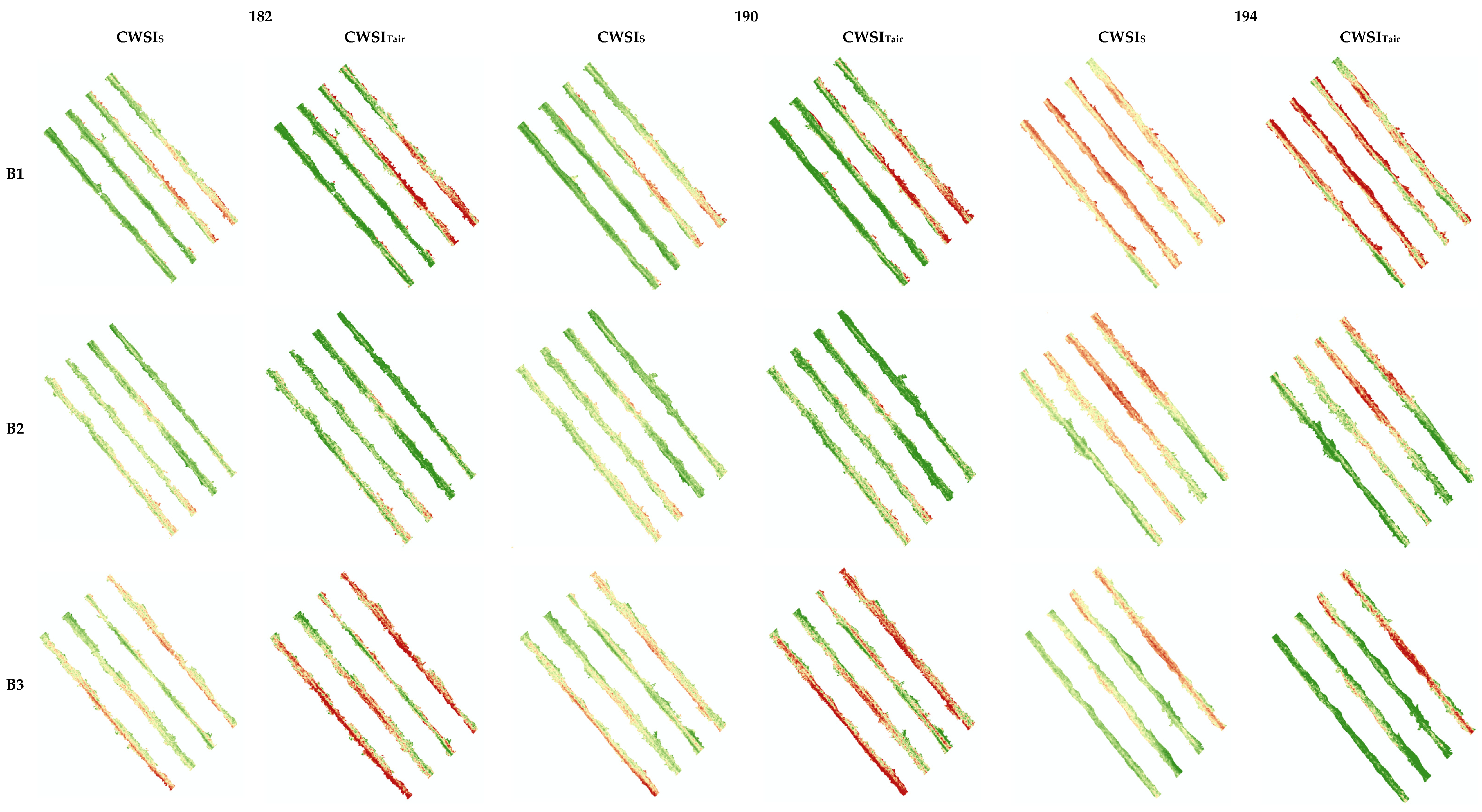
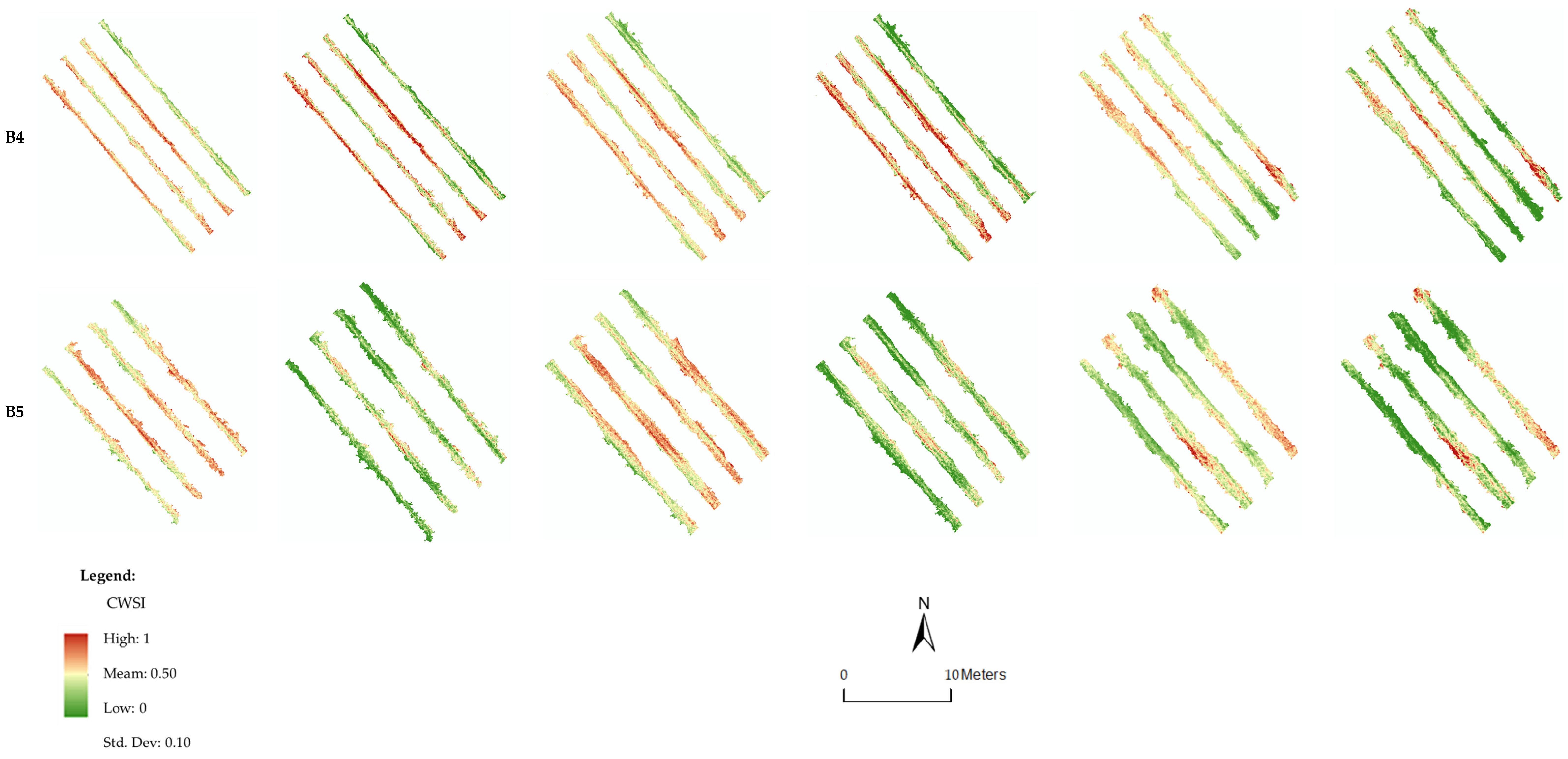
3.2. Calculation and Spatial Representation of Crop Water Stress Index (CWSI)

For this process, image segmentation was used, so that only the temperature affected by the vine canopy was used. It was based on this new image that the CWSI was processed (Figure 4).
To calculate the CWSI (CWSIS and CWSITair), different reference values were needed, depending on the method, to identify the difference in Twet and Tdry values (Table 2). The Twet for the CWSIS had values of 25.5, 26.1 and 25.5 °C for DOY 182, 190, 194, respectively, all of which were lower than the air temperature. The CWSITair, presented values of 28.9, 29.0 and 27.8 °C, all of which were higher than the air temperature. The CWSIS method resulted in lower Twet values compared to CWSITair, which may have been due to the lower percentage of the histogram used in the first method. The Tdry for the CWSIS had values of 38.2, 38.4 and 36.0 °C, and for the CWSITair these were 35, 35 and 33 °C. The CWSIS method resulted in higher Tdry values compared to the CWSITair method, probably because the air temperature method, by normalizing this indicator, made it more stable than in the simplified method, which depended on temperature variability existing within and between the blocks.
After obtaining the reference temperatures necessary to calculate CWSI, a spatial representation of the index was elaborated along the five blocks, where each pixel of the new image had its associated CWSI value, to determine if there was variability within and between blocks (Figure 5). The values for the two methods showed a range between 0 and 1 over the three DOY: the higher the value, the greater the water stress. CWSIs visually and numerically smoothed the data, whereas the CWSITair, by normalizing Tdry, shifted the values close to the extremes. In general, it appears that the values of the two CWSIS increased over the DOY, with a greater emphasis on the first block. It was also possible to verify a variation in CWSI within the sample block by changing the values represented, which may indicate plants with greater water stress in some areas.
The CWSIP values of the sampling point, calculated for validation, varied in amplitude over the three dates from 0.36 to 0.70. The averages increased over the reading days, decreasing the CWSIP amplitude. The same happened with the aerial sensors: the CWSIS had an overall amplitude between 0.35 and 0.78, and the average values of the CWSI increased while the amplitude decreased. For the CWSITair, the amplitude increased from 0.45 to 0.88, while the average values of the CWSI increased from 0.57 to 0.72, decreasing its amplitude (Table 3).
The portable and aerial CWSI values remained close among the three methods. There was a slight increase from DOY 182 to DOY 194, which was explained by the lower soil water content in the latter, confirmed by a slight increase in stem water potential (Table 3). It should be noted that the CWSITair had a very large coefficient of variation (0.42 to 0.44), whereas that of the CWSIs, on average, was less than half.
The soil water content varied between 110 and 199 mm for DOY 194 and DOY 182, respectively. The averages were 165, 159 and 144 mm for DOY 182, 190 and 194, respectively. All had low coefficients of variation (0.01–0.10). Thus, the water available in the soil decreased by about 20 mm overall (Table 4).

3.3. Correlation between Portable CWSI, Aerial CWSI and Stem Water Potential

To evaluate the relation between the proximal and remotely sensed water stress measurements with the vine water status, we determined the correlation between all the CWSI values (CWSITair, CWSIS and CWSIP) and the stem water potential (Ψst).
For each studied DOY (182, 190 and 194) the CWSIP had the highest correlation, and the CWSITair had the lowest correlation, with the Ψst (Table 5). These results are consistent with the global correlations, R2 = 0.59 for the CWSIP and R2 = 0.49 for the CWSITair.
When we compared the CWSI, the highest correlation was obtained between CWSIS and CWSIP (R2 = 0.58) (Table 5). The fact that there were no changes in the determination coefficients when the UAV-supported thermal CWSI was incorporated (CWSITair and CWSIS) suggested that the spatial structure represented the pattern of the stem water potential estimated from the simplified CWSI model.

4. Discussion

This study focused on the evaluation of thermal information to estimate the water status of a vineyard based on aerial and portable thermal images of the vine canopy. The method was fast and non-invasive compared to traditional methods such as using a pressure chamber to determine stem water potential. Using aerial thermal images captured with a UAV it was possible to produce an orthophotograph that comprised the temperature values of each pixel of the canopy. Segmentation of aerial RGB images isolated the canopy, discarded the area between the lines, facilitated calculation, and reduced thermal amplitudes that can influence the CWSI calculation model [16,17,49,55].
From analyzing the thermal images of three flights, it was possible to predict the water status of the plant (CWSI), taking into account the coefficient of determination when correlated with the stem water potential. Likewise, a moderate coefficient of determination was observed with the portable CWSI; however, this model did not allow a continuous surface of values. The results were in line with previous studies [17,49,55], but adding the ability to spatialize data, with the advantage of obtaining information from a vertical rather than a horizontal view.
Analyses of three days of capturing and processing data from portable thermal cameras and calculating respective CWSIP concerning the stem water potential (R2 = 0.59) showed a moderate correlation, which agreed with the work developed by Garcia-Tejero et al. [35]. The results for each day, DOY 182 (R2 = 0.69), DOY 190 (R2 = 0.60) and DOY 194 (R2 = 0.58) had moderate correlations, which enhanced estimates of plant water status from the CWSIP. According to [41], the variability observed between the stem water potential and the CWSI for different DOY can be affected by parameters related to the phenological phase of the crop. The CWSIP method, like use of the Scholander pressure chamber, is very expensive for determining an overall distribution because each reading only provides values for each plant in isolation.
Our results showed was possible to obtain crop water stress indices, calculated using date from two methods of aerial thermography, that made it possible to estimate and interpret the water status of the plant. Therefore, the method is as accurate as the Scholander pressure chamber method.
Given that it only needs to monitor air temperature during UAV flight, the calculation of the CWSITair is a quick method for obtaining thermal data and, consequently, calculation of the CWSI. With this method, a moderate coefficient of determination was obtained with the stem water potential (R2 = 0.49). It was observed that DOY 182 (R2 = 0.49), DOY 190 (R2 = 0.53) and DOY (R2 = 0.52), which had moderate correlations, were in agreement with the results obtained by [55].
The CWSIS calculation method required the least amount of time because it did not require field data. The correlation between the CWSIS and stem water potential (R2 = 0.55) showed a moderate correlation, which was in line with the findings of [16,49]. When the analysis was aggregated by days, DOY 182 (R2 = 0.60), DOY 190 (R2 = 0.59) and DOY (R2 = 0.54) had moderate correlations and with approximations superior to that of CWSITair.

5. Conclusions

In this work, the development of two CWSI spatialization methods was explored, and the results were compared with those obtained by measuring stem water potential. It was found that CWSIS could potentially estimate the water status of the vine using the reference temperatures (Twet and Tdry) from a histogram of image temperatures after segmentation.
The ability to obtain and spatialize thermal data has become extremely important, given that it is possible to image the plot as a whole, not just isolated plants. Furthermore, it is a non-invasive method, which allows taking a large number of measurements without weakening the plant in its phenological cycle. It also permits the collection and analysis of data on a large scale, and in a shorter time, whereas the CWSIS method more closely estimates water stress of the crop. The CWSIP method produced viable results, which were very close to those of the CWSIS, but it did not allow spatialization of the data.
Vegetation cover has a great influence on soil water preservation and thermal regulation. Where there is no turfgrass on the plot, the probability of obtaining a bimodal histogram can influence the CWSI results when applying the CWSIS or CWSITair methods.
Future research should consider information focused on leaf area, phenological phase, variety and age.

Author Contributions

Conceptualization, C.A.-P.; Funding acquisition, M.I.V.; Investigation, F.P. and S.M.; Methodology, C.A.-P. and M.I.V.; Validation, S.M. and M.I.V.; Writing—original draft, F.P.; Writing—review & editing, C.A.-P., S.M. and M.I.V. All authors have read and agreed to the published version of the manuscript.

Funding

This work is funded by the European Regional Development Fund (ERDF) through the Regional Operational Program North 2020, within the scope of Project TECH-Technology, Environment, Creativity and Health, Norte-01-0145-FEDER-000043.

Institutional Review Board Statement

Not applicable.

Informed Consent Statement

Not applicable.

Data Availability Statement

Not applicable.

Acknowledgments

This work was supported by project UIDP/05975/2020, proMetheus—Research Unit on Energy, Materials and Environment for Sustainability, and project UIDB/05937/2020––Center for Research and Development in Agrifood Systems and Sustainability (CISAS), through national funds from the Foundation for Science and Technology.

Conflicts of Interest

The authors declare no conflict of interest.

References

  1. Van Leeuwen, C.; Darriet, P. The Impact of Climate Change on Viticulture and Wine Quality. J. Wine Econ. 2016, 11, 150–167. [Google Scholar] [CrossRef] [Green Version]
  2. IPCC Climate Change 2021 Working Group I Contribution to the Sixth Assessment Report of the Intergovernmental Panel on Climate Change Summary for Policymakers.
  3. Jan van Oldenborgh, G.; Collins, M.; Arblaster, J.; Hesselbjerg Christensen, J.; Marotzke, J.; Power, S.B.; Rummukainen, M.; Zhou, T.; Wratt, D.; Zwiers, F.; et al. Climate Change 2013: The Physical Science Basis. Contribution of Working Group I; Intergovernmental Panel on Climate Change: Geneva, Switzerland, 2013. [Google Scholar]
  4. Cancela, J.J.; Trigo-Córdoba, E.; Martínez, E.M.; Rey, B.J.; Bouzas-Cid, Y.; Fandiño, M.; Mirás-Avalos, J.M. Effects of Climate Variability on Irrigation Scheduling in White Varieties of Vitis vinifera (L.) of NW Spain. Agric. Water Manag. 2016, 170, 99–109. [Google Scholar] [CrossRef]
  5. Raza, A.; Razzaq, A.; Mehmood, S.S.; Zou, X.; Zhang, X.; Lv, Y.; Xu, J. Impact of Climate Change on Crops Adaptation and Strategies to Tackle Its Outcome: A Review. Plants 2019, 8, 34. [Google Scholar] [CrossRef] [PubMed] [Green Version]
  6. Venios, X.; Korkas, E.; Nisiotou, A.; Banilas, G. Grapevine Responses to Heat Stress and Global Warming. Plants 2020, 9, 1754. [Google Scholar] [CrossRef] [PubMed]
  7. Rodrigues, P.; Pedroso, V.; Henriques, C.; Matos, A.; Reis, S.; Santos, J.A. Modelling the Phenological Development of Cv. Touriga Nacional and Encruzado in the Dão Wine Region, Portugal. OENO One 2021, 51, 337–352. [Google Scholar] [CrossRef]
  8. Kim, S.; Meki, M.N.; Kim, S.; Kiniry, J.R. Crop Modeling Application to Improve Irrigation Efficiency in Year-Round Vegetable Production in the Texaswinter Garden Region. Agronomy 2020, 10, 1525. [Google Scholar] [CrossRef]
  9. Silva, S.P.; Valín, M.I.; Mendes, S.; Araujo-Paredes, C.; Cancela, J.J.; Silva, L.L.; Barbosa, C.; Fitas Da Cruz, V.; Sousa, A.; Silva, R.; et al. Dual Crop Coefficient Approach in Vitis vinifera L. Cv. Loureiro. Agronomy 2021, 11, 2062. [Google Scholar] [CrossRef]
  10. Rodrigues, G.C.; Braga, R.P. Estimation of Reference Evapotranspiration during the Irrigation Season Using Nine Temperature-Based Methods in a Hot-Summer Mediterranean Climate. Agriculture 2021, 11, 124. [Google Scholar] [CrossRef]
  11. Cabral, I.L.; Carneiro, A.; Nogueira, T.; Queiroz, J. Regulated Deficit Irrigation and Its Effects on Yield and Quality of Vitis vinifera L., Touriga Francesa in a Hot Climate Area (Douro Region, Portugal). Agriculture 2021, 11, 774. [Google Scholar] [CrossRef]
  12. Jackson, R.D.; Idso, S.B.; Reginato, R.J.; Pinter, P.J. Canopy Temperature as a Crop Water Stress Indicator; John Wiley and Sons: Hoboken, NJ, USA, 1981; Volume 17. [Google Scholar]
  13. Idso, S.B. Non-water-stressed baselines: A key to measuring and interpreting plant water stress. Agric. Meteorol. 1982, 27, 57–70. [Google Scholar] [CrossRef]
  14. Fuentes, S.; de Bei, R.; Pech, J.; Tyerman, S. Computational Water Stress Indices Obtained from Thermal Image Analysis of Grapevine Canopies. Irrig. Sci. 2012, 30, 523–536. [Google Scholar] [CrossRef]
  15. Rustioni, L.; Rocchi, L.; Guffanti, E.; Cola, G.; Failla, O. Characterization of Grape (Vitis vinifera L.) Berry Sunburn Symptoms by Reflectance. J. Agric. Food Chem. 2014, 62, 3043–3046. [Google Scholar] [CrossRef] [Green Version]
  16. Santesteban, L.G.; di Gennaro, S.F.; Herrero-Langreo, A.; Miranda, C.; Royo, J.B.; Matese, A. High-Resolution UAV-Based Thermal Imaging to Estimate the Instantaneous and Seasonal Variability of Plant Water Status within a Vineyard. Agric. Water Manag. 2017, 183, 49–59. [Google Scholar] [CrossRef]
  17. Park, S.; Ryu, D.; Fuentes, S.; Chung, H.; Hernández-Montes, E.; O’Connell, M. Adaptive Estimation of Crop Water Stress in Nectarine and Peach Orchards Using High-Resolution Imagery from an Unmanned Aerial Vehicle (UAV). Remote Sens. 2017, 9, 828. [Google Scholar] [CrossRef] [Green Version]
  18. Matese, A.; di Gennaro, S.F. Practical Applications of a Multisensor UAV Platform Based on Multispectral, Thermal and RGB High Resolution Images in Precision Viticulture. Agriculture 2018, 8, 116. [Google Scholar] [CrossRef] [Green Version]
  19. Park, S.; Ryu, D.; Fuentes, S.; Chung, H.; O’connell, M.; Kim, J. Dependence of Cwsi-based Plant Water Stress Estimation with Diurnal Acquisition Times in a Nectarine Orchard. Remote Sens. 2021, 13, 2775. [Google Scholar] [CrossRef]
  20. Zarco-Tejada, P.J.; Rueda, C.A.; Ustin, S.L. Water Content Estimation in Vegetation with MODIS Reflectance Data and Model Inversion Methods. Remote Sens. Environ. 2003, 85, 109–124. [Google Scholar] [CrossRef]
  21. El-Shikha, D.M.; Barnes, E.M.; Clarke, T.R.; Hunsaker, D.J.; Haberland, J.A.; Pinter, P.J.; Waller, P.M.; Thompson, T.L.; Barnes, E.M.; Waller, P.M.; et al. Remote sensing of cotton nitrogen status using the canopy chlorophyll content index (CCCI). Trans. ASABE 2007, 51, 73–82. [Google Scholar] [CrossRef]
  22. Zhang, L.; Zhang, H.; Niu, Y.; Han, W. Mapping Maizewater Stress Based on UAV Multispectral Remote Sensing. Remote Sens. 2019, 11, 605. [Google Scholar] [CrossRef] [Green Version]
  23. Albetis, J.; Duthoit, S.; Guttler, F.; Jacquin, A.; Goulard, M.; Poilvé, H.; Féret, J.B.; Dedieu, G. Detection of Flavescence dorée Grapevine Disease Using Unmanned Aerial Vehicle (UAV) Multispectral Imagery. Remote Sens. 2017, 9, 308. [Google Scholar] [CrossRef]
  24. Yeom, J.; Jung, J.; Chang, A.; Ashapure, A.; Maeda, M.; Maeda, A.; Landivar, J. Comparison of Vegetation Indices Derived from UAV Data for Differentiation of Tillage Effects in Agriculture. Remote Sens. 2019, 11, 1548. [Google Scholar] [CrossRef] [Green Version]
  25. DadrasJavan, F.; Samadzadegan, F.; Seyed Pourazar, S.H.; Fazeli, H. UAV-Based Multispectral Imagery for Fast Citrus Greening Detection. J. Plant Dis. Prot. 2019, 126, 307–318. [Google Scholar] [CrossRef]
  26. Adam, E.; Mutanga, O.; Rugege, D. Multispectral and Hyperspectral Remote Sensing for Identification and Mapping of Wetland Vegetation: A Review. Wetl. Ecol. Manag. 2010, 18, 281–296. [Google Scholar] [CrossRef]
  27. Aasen, H.; Burkart, A.; Bolten, A.; Bareth, G. Generating 3D Hyperspectral Information with Lightweight UAV Snapshot Cameras for Vegetation Monitoring: From Camera Calibration to Quality Assurance. ISPRS J. Photogramm. Remote Sens. 2015, 108, 245–259. [Google Scholar] [CrossRef]
  28. Gonzalez-Dugo, V.; Hernandez, P.; Solis, I.; Zarco-Tejada, P.J. Using High-Resolution Hyperspectral and Thermal Airborne Imagery to Assess Physiological Condition in the Context of Wheat Phenotyping. Remote Sens. 2015, 7, 13586–13605. [Google Scholar] [CrossRef] [Green Version]
  29. Bellvert, J.; Marsal, J.; Mata, M.; Girona, J. Identifying Irrigation Zones across a 7.5-Ha “Pinot Noir” Vineyard Based on the Variability of Vine Water Status and Multispectral Images. Irrig. Sci. 2012, 30, 499–509. [Google Scholar] [CrossRef]
  30. Bellvert, J.; Zarco-Tejada, P.J.; Girona, J.; Fereres, E. Mapping Crop Water Stress Index in a ‘Pinot-Noir’ Vineyard: Comparing Ground Measurements with Thermal Remote Sensing Imagery from an Unmanned Aerial Vehicle. Precis. Agric. 2014, 15, 361–376. [Google Scholar] [CrossRef]
  31. Pôças, I.; Gonçalves, J.; Costa, P.M.; Gonçalves, I.; Pereira, L.S.; Cunha, M. Hyperspectral-Based Predictive Modelling of Grapevine Water Status in the Portuguese Douro Wine Region. Int. J. Appl. Earth Obs. Geoinf. 2017, 58, 177–190. [Google Scholar] [CrossRef]
  32. Pádua, L.; Adão, T.; Sousa, A.; Peres, E.; Sousa, J.J. Individual Grapevine Analysis in a Multi-Temporal Context Using UAV-Based Multi-Sensor Imagery. Remote Sens. 2020, 12, 139. [Google Scholar] [CrossRef] [Green Version]
  33. De Oliveira, A.F.; Mameli, M.G.; Lo Cascio, M.; Sirca, C.; Satta, D. An Index for User-Friendly Proximal Detection of Water Requirements to Optimized Irrigation Management in Vineyards. Agronomy 2021, 11, 323. [Google Scholar] [CrossRef]
  34. Maes, W.H.; Steppe, K. Estimating Evapotranspiration and Drought Stress with Ground-Based Thermal Remote Sensing in Agriculture: A Review. J. Exp. Bot. 2012, 63, 4671–4712. [Google Scholar] [CrossRef] [PubMed] [Green Version]
  35. García-Tejero, I.F.; Costa, J.M.; Egipto, R.; Durán-Zuazo, V.H.; Lima, R.S.N.; Lopes, C.M.; Chaves, M.M. Thermal Data to Monitor Crop-Water Status in Irrigated Mediterranean Viticulture. Agric. Water Manag. 2016, 176, 80–90. [Google Scholar] [CrossRef]
  36. Jones, H.G. Plants and Microclimate: A Quantitative Approach to Environmental Plant Physiology; Cambridge University Press: Cambridge, UK, 1995. [Google Scholar]
  37. Zarco-Tejada, P.J.; González-Dugo, V.; Berni, J.A.J. Fluorescence, Temperature and Narrow-Band Indices Acquired from a UAV Platform for Water Stress Detection Using a Micro-Hyperspectral Imager and a Thermal Camera. Remote Sens. Environ. 2012, 117, 322–337. [Google Scholar] [CrossRef]
  38. Gago, J.; Douthe, C.; Coopman, R.E.; Gallego, P.P.; Ribas-Carbo, M.; Flexas, J.; Escalona, J.; Medrano, H. UAVs Challenge to Assess Water Stress for Sustainable Agriculture. Agric. Water Manag. 2015, 153, 9–19. [Google Scholar] [CrossRef]
  39. Grant, O.M.; Ochagavía, H.; Baluja, J.; Diago, M.P.; Tardáguila, J. Thermal Imaging to Detect Spatial and Temporal Variation in the Water Status of Grapevine (Vitis vinifera L.). J. Hortic. Sci. Biotechnol. 2016, 91, 44–55. [Google Scholar] [CrossRef]
  40. García-Tejero, I.F.; Rubio, A.E.; Viñuela, I.; Hernández, A.; Gutiérrez-Gordillo, S.; Rodríguez-Pleguezuelo, C.R.; Durán-Zuazo, V.H. Thermal Imaging at Plant Level to Assess the Crop-Water Status in Almond Trees (Cv. Guara) under Deficit Irrigation Strategies. Agric. Water Manag. 2018, 208, 176–186. [Google Scholar] [CrossRef]
  41. Bellvert, J.; Marsal, J.; Girona, J.; Zarco-Tejada, P.J. Seasonal Evolution of Crop Water Stress Index in Grapevine Varieties Determined with High-Resolution Remote Sensing Thermal Imagery. Irrig. Sci. 2015, 33, 81–93. [Google Scholar] [CrossRef]
  42. Matese, A.; Toscano, P.; di Gennaro, S.F.; Genesio, L.; Vaccari, F.P.; Primicerio, J.; Belli, C.; Zaldei, A.; Bianconi, R.; Gioli, B. Intercomparison of UAV, Aircraft and Satellite Remote Sensing Platforms for Precision Viticulture. Remote Sens. 2015, 7, 2971–2990. [Google Scholar] [CrossRef] [Green Version]
  43. Egea, G.; Padilla-Díaz, C.M.; Martinez-Guanter, J.; Fernández, J.E.; Pérez-Ruiz, M. Assessing a Crop Water Stress Index Derived from Aerial Thermal Imaging and Infrared Thermometry in Super-High Density Olive Orchards. Agric. Water Manag. 2017, 187, 210–221. [Google Scholar] [CrossRef] [Green Version]
  44. Shackel, K.; Buchner, R.; Connell, J.; Edstrom, J.; Fulton, A.; Holtz, B.; Krueger, B.; Lampinen, B.; Olson, B.; Ramos, D.; et al. A Plant-Based Approach to Deficit Irrigation in Trees and Vines. HortScience 2010, 46, 173–177. [Google Scholar] [CrossRef]
  45. Acevedo-Opazo, C.; Ortega-Farias, S.; Fuentes, S. Effects of Grapevine (Vitis vinifera L.) Water Status on Water Consumption, Vegetative Growth and Grape Quality: An Irrigation Scheduling Application to Achieve Regulated Deficit Irrigation. Agric. Water Manag. 2010, 97, 956–964. [Google Scholar] [CrossRef]
  46. Di Gennaro, S.F.; Dainelli, R.; Palliotti, A.; Toscano, P.; Matese, A. Sentinel-2 Validation for Spatial Variability Assessment in Overhead Trellis System Viticulture versus UAV and Agronomic Data. Remote Sens. 2019, 11, 2573. [Google Scholar] [CrossRef] [Green Version]
  47. Giovos, R.; Tassopoulos, D.; Kalivas, D.; Lougkos, N.; Priovolou, A. Remote Sensing Vegetation Indices in Viticulture: A Critical Review. Agriculture 2021, 11, 457. [Google Scholar] [CrossRef]
  48. Anda, A.; Simon-Gáspár, B.; Soós, G. The Application of a Self-Organizing Model for the Estimation of Crop Water Stress Index (Cwsi) in Soybean with Different Watering Levels. Water 2021, 13, 3306. [Google Scholar] [CrossRef]
  49. Bian, J.; Zhang, Z.; Chen, J.; Chen, H.; Cui, C.; Li, X.; Chen, S.; Fu, Q. Simplified Evaluation of Cotton Water Stress Using High Resolution Unmanned Aerial Vehicle Thermal Imagery. Remote Sens. 2019, 11, 267. [Google Scholar] [CrossRef] [Green Version]
  50. Alordzinu, K.E.; Li, J.; Lan, Y.; Appiah, S.A.; al Aasmi, A.; Wang, H. Rapid Estimation of Crop Water Stress Index on Tomato Growth. Sensors 2021, 21, 5142. [Google Scholar] [CrossRef] [PubMed]
  51. Noguera, M.; Millán, B.; Pérez-Paredes, J.J.; Ponce, J.M.; Aquino, A.; Andújar, J.M. A New Low-Cost Device Based on Thermal Infrared Sensors for Olive Tree Canopy Temperature Measurement and Water Status Monitoring. Remote Sens. 2020, 12, 723. [Google Scholar] [CrossRef] [Green Version]
  52. Matese, A.; Baraldi, R.; Berton, A.; Cesaraccio, C.; di Gennaro, S.F.; Duce, P.; Facini, O.; Mameli, M.G.; Piga, A.; Zaldei, A. Estimation of Water Stress in Grapevines Using Proximal and Remote Sensing Methods. Remote Sens. 2018, 10, 114. [Google Scholar] [CrossRef] [Green Version]
  53. Zhou, Z.; Diverres, G.; Kang, C.; Thapa, S.; Karkee, M.; Zhang, Q.; Keller, M. Ground-Based Thermal Imaging for Assessing Crop Water Status in Grapevines over a Growing Season. Agronomy 2022, 12, 322. [Google Scholar] [CrossRef]
  54. Cogato, A.; Jewan, S.Y.Y.; Wu, L.; Marinello, F.; Meggio, F.; Sivilotti, P.; Sozzi, M.; Pagay, V. Water Stress Impacts on Grapevines (Vitis vinifera L.) in Hot Environments: Physiological and Spectral Responses. Agronomy 2022, 12, 1819. [Google Scholar] [CrossRef]
  55. Möller, M.; Alchanatis, V.; Cohen, Y.; Meron, M.; Tsipris, J.; Naor, A.; Ostrovsky, V.; Sprintsin, M.; Cohen, S. Use of Thermal and Visible Imagery for Estimating Crop Water Status of Irrigated Grapevine. J. Exp. Bot. 2007, 58, 827–838. [Google Scholar] [CrossRef] [PubMed] [Green Version]
  56. Gonzalez-Dugo, V.; Zarco-Tejada, P.; Nicolás, E.; Nortes, P.A.; Alarcón, J.J.; Intrigliolo, D.S.; Fereres, E. Using High Resolution UAV Thermal Imagery to Assess the Variability in the Water Status of Five Fruit Tree Species within a Commercial Orchard. Precis. Agric. 2013, 14, 660–678. [Google Scholar] [CrossRef]
  57. Rud, R.; Cohen, Y.; Alchanatis, V.; Levi, A.; Brikman, R.; Shenderey, C.; Heuer, B.; Markovitch, T.; Dar, Z.; Rosen, C.; et al. Crop Water Stress Index Derived from Multi-Year Ground and Aerial Thermal Images as an Indicator of Potato Water Status. Precis. Agric. 2014, 15, 273–289. [Google Scholar] [CrossRef]
  58. Meron, M.; Sprintsin, M.; Tsipris, J.; Alchanatis, V.; Cohen, Y. Foliage Temperature Extraction from Thermal Imagery for Crop Water Stress Determination. Precis. Agric. 2013, 14, 467–477. [Google Scholar] [CrossRef]
  59. Kottek, M.; Grieser, J.; Beck, C.; Rudolf, B.; Rubel, F. World Map of the Köppen-Geiger Climate Classification Updated. Meteorol. Z. 2006, 15, 259–263. [Google Scholar] [CrossRef]
  60. FLIR. FLIR. Available online: https://www.flir.com (accessed on 2 April 2022).
  61. DJI. MATRICE 200 SERIESSpecs. Available online: https://www.dji.com/pt/matrice-200-series?msclkid=8281f8b6b29b11ecac3bf72c7c709ecd (accessed on 2 April 2022).
  62. FLIR. Flir Tools. Available online: https://flir-br.custhelp.com/app/answers/detail/a_id/1453/~/download-flir-tools/session (accessed on 2 April 2022).
  63. Cohen, Y.; Alchanatis, V.; Meron, M.; Saranga, Y.; Tsipris, J. Estimation of Leaf Water Potential by Thermal Imagery and Spatial Analysis. J. Exp. Bot. 2005, 56, 1843–1852. [Google Scholar] [CrossRef] [Green Version]
  64. Ben-Gal, A.; Agam, N.; Alchanatis, V.; Cohen, Y.; Yermiyahu, U.; Zipori, I.; Presnov, E.; Sprintsin, M.; Dag, A. Evaluating Water Stress in Irrigated Olives: Correlation of Soil Water Status, Tree Water Status, and Thermal Imagery. Irrig. Sci. 2009, 27, 367–376. [Google Scholar] [CrossRef]
  65. Agam, N.; Segal, E.; Peeters, A.; Levi, A.; Dag, A.; Yermiyahu, U.; Ben-Gal, A. Spatial Distribution of Water Status in Irrigated Olive Orchards by Thermal Imaging. Precis. Agric. 2014, 15, 346–359. [Google Scholar] [CrossRef]
Figure 1. (a) Plot location in the northwest of Portugal. (b) Experimental design with five blocks (B1, B2, B3, B4 and B5) consisting of four rows with seven vines.
Sensors 22 08056 g001
Figure 2. Flow diagram for calculating CWSIS and CWSITair and their spatialization.
Sensors 22 08056 g002
Figure 3. (a) Study area thermal orthophoto on different DOY. (b) Distribution temperature histogram relative to the soil and vineyard.
Sensors 22 08056 g003
Figure 4. (a) Maps with the segmentation image. (b) Vine green vegetation considered for calculating canopy temperature.
Sensors 22 08056 g004
Figure 5. Maps of the five blocks of the CWSIS and CWSITair by DOY.
Sensors 22 08056 g005aSensors 22 08056 g005b
Table 1. Statistics (average, median and standard deviation) of temperature taken with an aerial camera, relative humidity (HR %) and air temperature (Tair °C) on the three data collection days of the year (DOY).
Statistics (°C)TairHR
DOYAverageMedianSt. DevMin.Max.(°C)%
18231.931.82.519.351.32860
19031.931.82.419.251.22855
19430.330.22.219.746.12656
Table 2. Different methods of calculating Twet and Tdry by DOY.
CWSI TypesMethodsDOYTwet (°C)Tdry (°C)
CWSITairCanopy temperature histogram (33% lowest)18228.9-
19029.0-
19427.8-
TAir + 7 °C182-35.0
190-35.0
194-33.0
CWSISCanopy temperature histogram (1%) 118225.538.2
19026.138.4
19425.536.0
1 Average of the lowest and highest 0.5% of values in the canopy temperature histogram.
Table 3. Statistics for CWSI portable (CWSIP), CWSI air temperature (CWSITair), CWSI simplified (CWSIS), and water potential (Ψst) for the three DOY.
DOYDescriptive
Statistics
CWSIPCWSITairCWSISΨst (MPa)
182minimum0.360.450.35−0.45
maximum0.700.880.78−0.70
average0.540.600.50−0.53
CV0.180.440.200.13
190minimum0.400.460.35−0.40
maximum0.680.820.70−0.60
average0.570.650.55−0.51
CV0.160.430.180.12
194minimum0.420.570.44−0.50
maximum0.680.780.67−0.75
average0.610.720.59−0.61
CV0.110.420.120.11
Table 4. Statistics for soil water content (θ; mm) for the three dates (DOY).
DOYDescriptive
Statistics
B1B2B3B4B5
182minimum153.39162.71157.84149.50134.77
maximum186.52166.38199.37177.01160.20
average171.45164.60171.63163.28147.48
CV0.070.010.090.060.07
190minimum147.87154.56153.78141.76126.87
maximum179.07164.55195.76170.77153.73
average161.50159.63166.24156.23140.30
CV0.070.030.100.070.08
194minimum132.54137.22143.56126.53110.72
maximum168.60153.23182.01159.45144.80
average146.93147.31154.64142.87127.76
CV0.090.050.100.080.10
Table 5. Determination coefficients (R2) of the different CWSIS and the stem water potential (Ψst).
CorrelationGlobal
n = 60
(p < 0.05)
DOY 182
n = 20
(p < 0.05)
DOY 190
n = 20
(p < 0.05)
DOY 194
n = 20
(p < 0.05)
CWSIP/(Ψst)0.59
(y = −0.6734x + 0.2063)
0.690.600.58
CWSIS/(Ψst)0.55
(y = −0.7x + 0.165)
0.600.590.54
CWSITair/Ψst0.49
(y = −0.6182x + 0.3216)
0.490.530.52
CWSIS/CWSIP0.58
(y = 0.6468x + 0.2198)
0.590.600.57
CWSITair/CWSIP0.34
(y = 0.3406x + 0.3487)
0.300.350.34
Publisher’s Note: MDPI stays neutral with regard to jurisdictional claims in published maps and institutional affiliations.

