Geohazard Characterization, Modeling, and Risk Assessment
A project collection of GeoHazards (ISSN 2624-795X).
Papers displayed on this page all arise from the same project. Editorial decisions were made independently of project staff and handled by the Editor-in-Chief or qualified Editorial Board members.
Viewed by 12330
Share This Project Collection
Editors
 Dr. Tiago Miguel Ferreira
Dr. Tiago Miguel Ferreira
E-Mail
Website
Guest Editor
Department of Geography and Environmental Management, University of the West of England-UWE Bristol, Frenchay Campus, Bristol BS16 1QY, UK
Interests: multi-hazard risk analysis; risk and vulnerability reduction; seismic vulnerability; seismic rehabilitation and retrofit; urban resilience; disaster response and reconstruction; geographic information systems
Special Issues, Collections and Topics in MDPI journals
Project Overview
Dear Colleagues,
This Special Feature Issue calls for papers to deal with mapping, analyzing and modeling natural and human-induced hazards, as well as risk assessment and the reduction of geohazards. We welcome review papers, orginal research articles amd technical notes on mapping, monitoring, modeling, and risk and vulnerability assessment and the reduction of various gehazards. In particular, we solicit each of the Editorial Board Members to contribute a manuscript to this special collection.
Prof. Dr. Zhong Lu
Dr. Tiago Miguel Ferreira
Guest Editors
Manuscript Submission Information
Manuscripts should be submitted online at www.mdpi.com by registering and logging in to this website. Once you are registered, click here to go to the submission form. Manuscripts can be submitted until the deadline. All submissions that pass pre-check are peer-reviewed. Accepted papers will be published continuously in the journal (as soon as accepted) and will be listed together on the collection website. Research articles, review articles as well as short communications are invited. For planned papers, a title and short abstract (about 100 words) can be sent to the Editorial Office for announcement on this website.
Submitted manuscripts should not have been published previously, nor be under consideration for publication elsewhere (except conference proceedings papers). All manuscripts are thoroughly refereed through a single-blind peer-review process. A guide for authors and other relevant information for submission of manuscripts is available on the Instructions for Authors page. GeoHazards is an international peer-reviewed open access quarterly journal published by MDPI.
Please visit the Instructions for Authors page before submitting a manuscript.
The Article Processing Charge (APC) for publication in this open access journal is 1000 CHF (Swiss Francs).
Submitted papers should be well formatted and use good English. Authors may use MDPI's
English editing service prior to publication or during author revisions.
Keywords
- geohazards
- mapping
- modeling
- risk assessment
- vulnerability
- societal impacts
Published Papers (6 papers)
Open AccessArticle
Rapid Earthquake Damage Assessment System in the Black Sea Basin: Selection/Adoption of Ground Motion Prediction Equations with Emphasis in the Cross-Border Areas
by
Nikolaos Theodoulidis, Basil Margaris, Dimitris Sotiriadis, Can Zulfikar, Seyhan Okuyan Akcan, Carmen Ortanza Cioflan, Elena Florinela Manea and Dragos Toma-Danila
Viewed by 755
Abstract
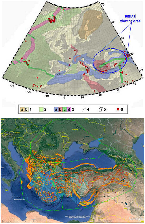
In the present study, an effort to propose and adopt appropriate Ground Motion Prediction Equations (GMPEs) for the Rapid Earthquake Damage Assessment System (REDAS) in the Black Sea basin is attempted. Emphasis of GMPE harmonization in the cross-border areas (CBA) is given. For
[...] Read more.
In the present study, an effort to propose and adopt appropriate Ground Motion Prediction Equations (GMPEs) for the Rapid Earthquake Damage Assessment System (REDAS) in the Black Sea basin is attempted. Emphasis of GMPE harmonization in the cross-border areas (CBA) is given. For this reason, two distinct sub-areas are investigated, taking into consideration their seismotectonic regime. One sub-area refers to active shallow crustal earthquakes (Greece-Turkey, CBA) and the other to intermediate-depth and shallow crustal earthquakes (Romania-Moldova, Western Black Sea CBA). Testing and ranking of pre-selected GMPEs has been performed using strong motion data of the broader CBA regions of both sub-areas. The final proposed GMPEs to feed the REDA System may assure the effective estimation of ShakeMaps and—in combination with the appropriate vulnerability curves—reliable near-real-time damage assessment in the cross-border earthquake affected areas.
Full article
►▼
Show Figures
Open AccessArticle
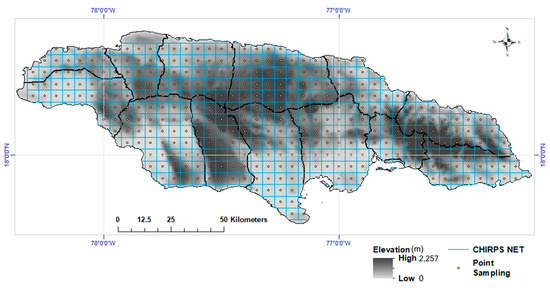
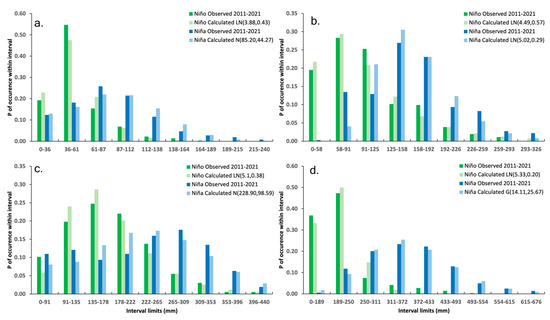
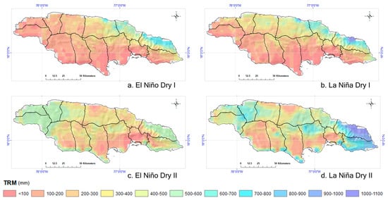
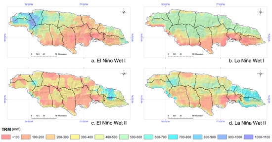
ENSO Impacts on Jamaican Rainfall Patterns: Insights from CHIRPS High-Resolution Data for Disaster Risk Management
by
Cheila Avalon-Cullen, Rafea Al Suhili, Nathaniel K. Newlands, Christy Caudill, Harvey Hill, Jaqueline Spence-Hemmings and Markus Enenkel
Viewed by 1233
Abstract
This study examines the influence of the El Niño Southern Oscillation (ENSO) on Jamaica’s rainfall patterns, leveraging CHIRPS data from 1981 to 2021 in 370 locations. Our analysis reveals a distinct ENSO imprint on rainfall, with La Niña phases showing a consistently higher
[...] Read more.
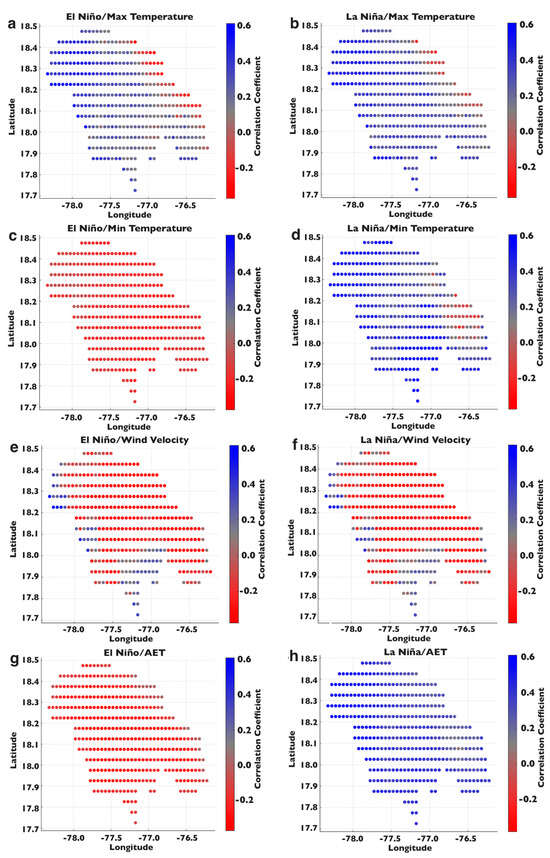
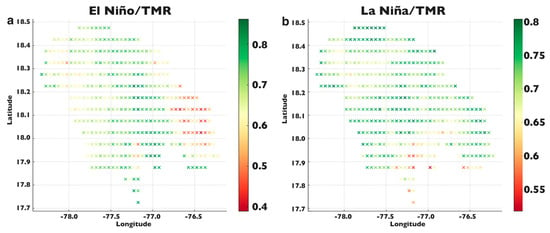
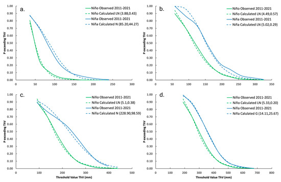
This study examines the influence of the El Niño Southern Oscillation (ENSO) on Jamaica’s rainfall patterns, leveraging CHIRPS data from 1981 to 2021 in 370 locations. Our analysis reveals a distinct ENSO imprint on rainfall, with La Niña phases showing a consistently higher probability of exceeding various rainfall thresholds compared to El Niño. Notably, La Niña increases the likelihood of heavier rainfall, particularly in the wet seasons, with probabilities of exceeding 200 mm reaching up to 50% during wet season II. Spatially, the probability of total monthly rainfall (TMR) during La Niña is elevated in the northeastern regions, suggesting regional vulnerability to excess rainfall. Additionally, during El Niño, the correlation between TMR and the maximum air temperature (Tmax) is significantly stronger, indicating a positive and more pronounced relationship between higher temperatures and rainfall, with correlation coefficients ranging from 0.39 to 0.80. Wind speed and evapotranspiration show a negligible influence on TMR during both ENSO phases, maintaining stable correlation patterns with only slight variations. The results of this study underscore the necessity for differentiated regional strategies in water resource management and disaster preparedness, tailored to the unique climatic characteristics imposed by ENSO variability. These insights contribute to a refined understanding of climate impacts, essential for enhancing resilience and adaptive capacity in Jamaica and other small island developing states.
Full article
►▼
Show Figures
Open AccessArticle
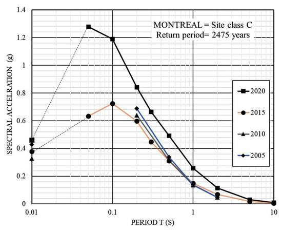
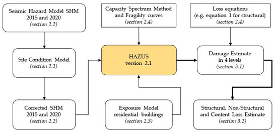
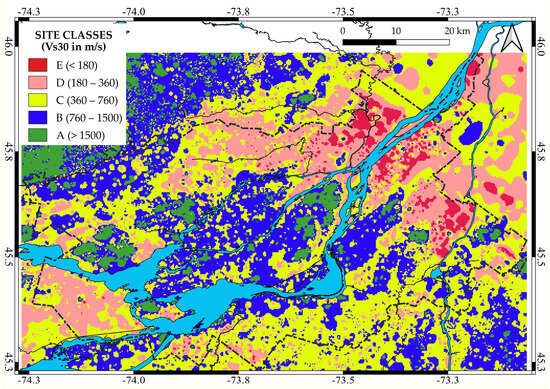
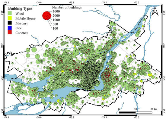
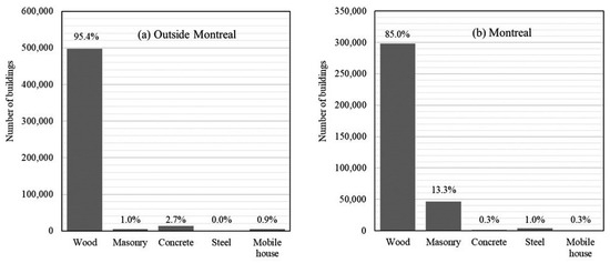
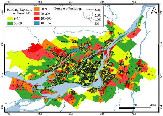
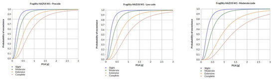
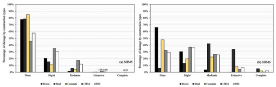
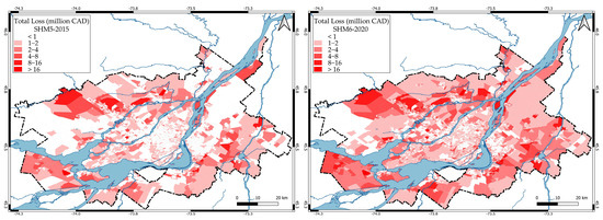
Influence of the 2020 Seismic Hazard Update on Residential Losses in Greater Montreal, Canada
by
Philippe Rosset, Xuejiao Long and Luc Chouinard
Viewed by 1248
Abstract
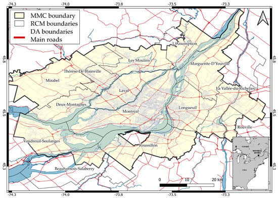
Greater Montreal is situated in a region with moderate seismic activity and rests on soft ground deposits from the ancient Champlain Sea, as well as more recent alluvial deposits from the Saint Lawrence River. These deposits have the potential to amplify seismic waves,
[...] Read more.
Greater Montreal is situated in a region with moderate seismic activity and rests on soft ground deposits from the ancient Champlain Sea, as well as more recent alluvial deposits from the Saint Lawrence River. These deposits have the potential to amplify seismic waves, as demonstrated by past strong, and recent weak, earthquakes. Studies based on the 2015 National Seismic Hazard Model (SHM5) had estimated losses to residential buildings at 2% of their value for an event with a return period of 2475 years. In 2020, the seismic hazard model was updated (SHM6), resulting in more severe hazards for eastern Canada. This paper aims to quantify the impact of these changes on losses to residential buildings in Greater Montreal. Our exposure database includes population and buildings at the scale of dissemination areas (500–1000 inhabitants). Buildings are classified by occupancy and construction type and grouped into three building code levels based on year of construction. The value of buildings is obtained from property-valuation rolls and the content value is derived from insurance data. Damage and losses are calculated using Hazus software developed for FEMA. Losses are shown to be 53% higher than the SHM5 estimates.
Full article
►▼
Show Figures
Open AccessArticle
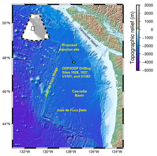
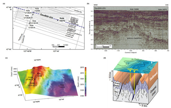
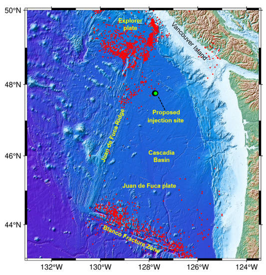
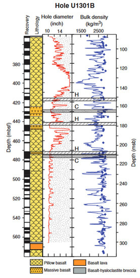
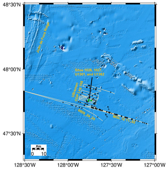
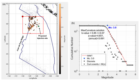
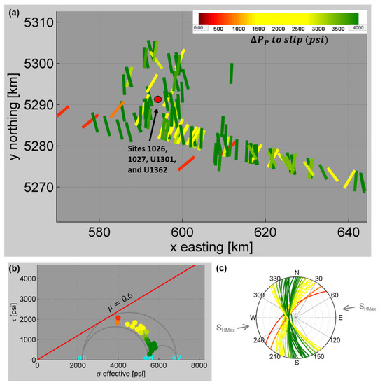
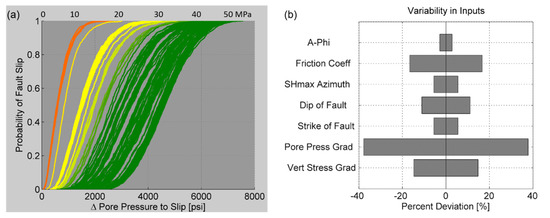
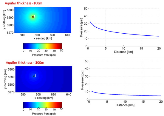
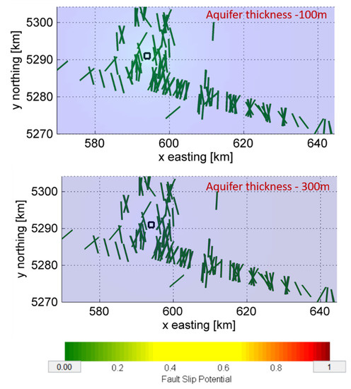
Fault Slip Tendency Analysis for a Deep-Sea Basalt CO2 Injection in the Cascadia Basin
by
Eneanwan Ekpo Johnson, Martin Scherwath, Kate Moran, Stan E. Dosso and Kristin M. Rohr
Cited by 2 | Viewed by 2568
Abstract
Offshore basalts, most commonly found as oceanic crust formed at mid-ocean ridges, are estimated to offer an almost unlimited reservoir for CO
2 sequestration and are regarded as one of the most durable locations for carbon sequestration since injected CO
2 will mineralize,
[...] Read more.
Offshore basalts, most commonly found as oceanic crust formed at mid-ocean ridges, are estimated to offer an almost unlimited reservoir for CO
2 sequestration and are regarded as one of the most durable locations for carbon sequestration since injected CO
2 will mineralize, forming carbonate rock. As part of the Solid Carbon project, the potential of the Cascadia Basin, about 200 km off the west coast of Vancouver Island, Canada, is investigated as a site for geological CO
2 sequestration. In anticipation of a demonstration proposed to take place, it is essential to assess the tendency of geologic faults in the area to slip in the presence of CO
2 injection, potentially causing seismic events. To understand the viability of the reservoir, a quantitative risk assessment of the proposed site area was conducted. This involved a detailed characterization of the proposed injection site to understand baseline stress and pressure conditions and identify individual faults or fault zones with the potential to slip and thereby generate seismicity. The results indicate that fault slip potential is minimal (less than 1%) for a constant injection of up to ~2.5 MT/yr. This is in part due to the thickness of the basalt aquifer and its permeability. The results provide a reference for assessing the potential earthquake risk from CO
2 injection in similar ocean basalt basins.
Full article
►▼
Show Figures
Open AccessArticle
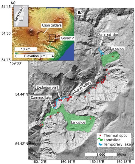
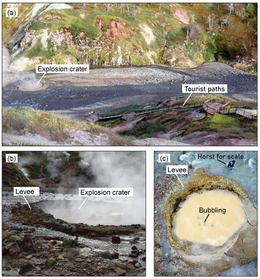
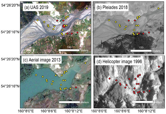
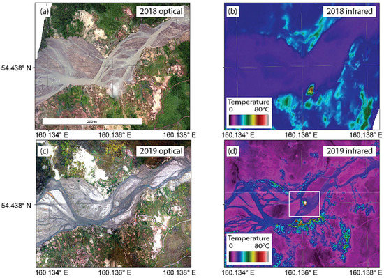
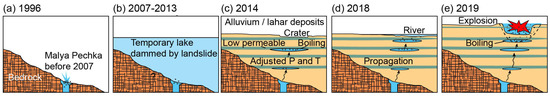
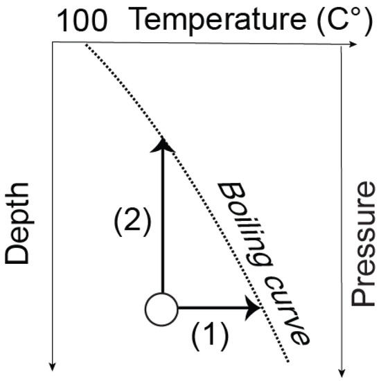
Geothermal Explosion at the 2014 Landslide-Covered Area of the Geyser Valley, Kamchatka, Russian Far East
by
Masoud Allahbakhshi, Alina V. Shevchenko, Alexander B. Belousov, Marina G. Belousova, Horst Kämpf and Thomas R. Walter
Cited by 1 | Viewed by 1757
Abstract
Geyser geothermal fields are scenic volcanic landforms that often contain tens to hundreds of thermal spot vents that erupt boiling water or contain bubbling mud pools. The fields are potentially hazardous sites due to boiling water temperatures and changes in vent locations and
[...] Read more.
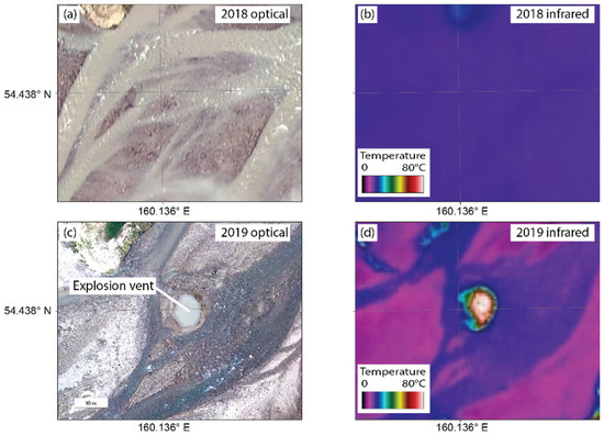
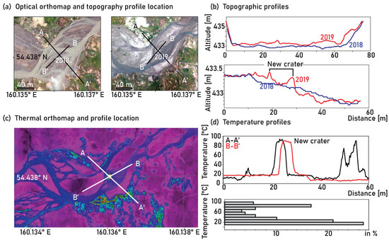
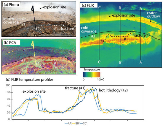
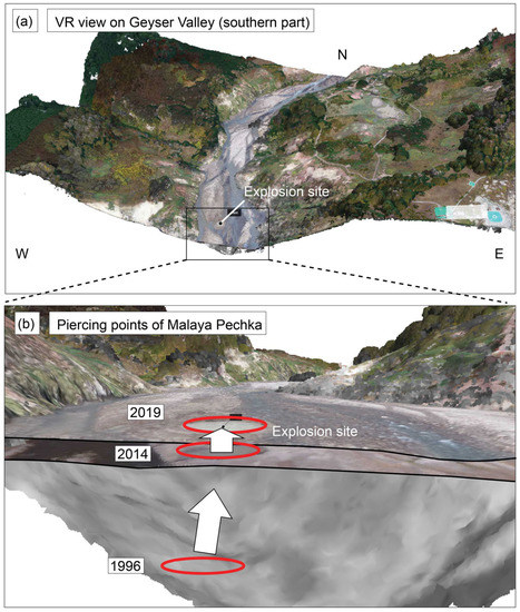
Geyser geothermal fields are scenic volcanic landforms that often contain tens to hundreds of thermal spot vents that erupt boiling water or contain bubbling mud pools. The fields are potentially hazardous sites due to boiling water temperatures and changes in vent locations and eruption dynamics, which are poorly understood. Here we report on the rapid and profound changes that can affect such a geyser field and ultimately lead to a dangerous, unanticipated eruption. We studied the Geyser Valley, Kamchatka Peninsula, which is a field of geysers and other thermal features and boiling pools. Using high-resolution tri-stereo satellite data and unmanned aerial systems (UAS) with optical and thermal infrared cameras in 2018 and 2019, we were able to identify a newly emerging explosion site. Structure-from-motion analysis of data acquired before and after the explosion reveals morphological and thermal details of the new vent. The explosion site produced an aureole zone of more than 150 m
3 of explosively redeposited gravel and clay, a slightly elliptical crater with a diameter of 7.5 m and a crater rim 0.30 m high. However, comparison with archives of photogrammetric data suggests that this site was thermally active years earlier and contained a crater that was obscured and covered by landslides and river sediments. The results allow us to develop a conceptual model and highlight the hazard potential of thermal features buried by landslides and clastic deposits. Sudden explosions may occur at similar sites elsewhere, highlighting the need for careful assessment and monitoring of geomorphological and hydrological changes at geyser sites in other regions.
Full article
►▼
Show Figures
Open AccessFeature PaperArticle
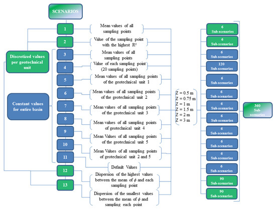
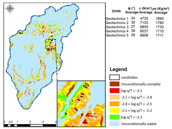
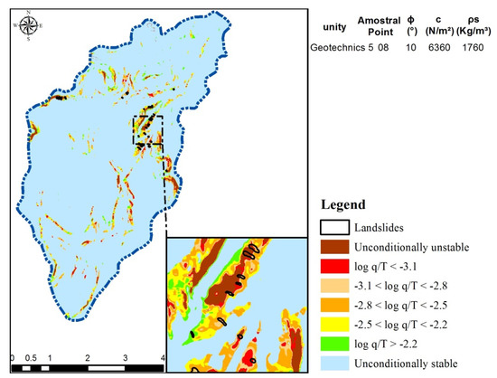
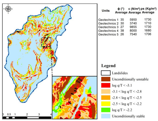
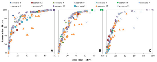
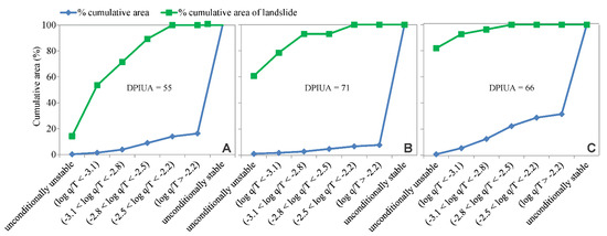
The Relevance of Geotechnical-Unit Characterization for Landslide-Susceptibility Mapping with SHALSTAB
by
Carla Moreira Melo, Masato Kobiyama, Gean Paulo Michel and Mariana Madruga de Brito
Cited by 5 | Viewed by 2886
Abstract
Given the increasing occurrence of landslides worldwide, the improvement of predictive models for landslide mapping is needed. Despite the influence of geotechnical parameters on SHALSTAB model outputs, there is a lack of research on models’ performance when considering different variables. In particular, the
[...] Read more.
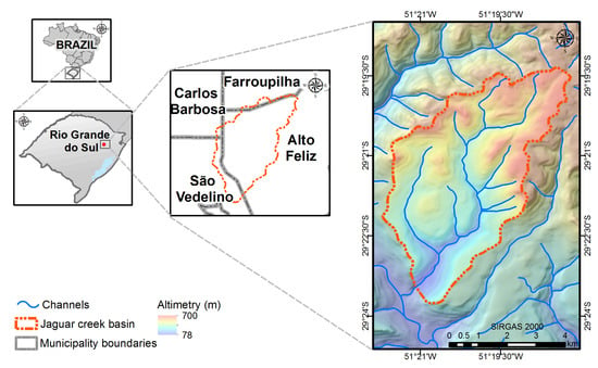
Given the increasing occurrence of landslides worldwide, the improvement of predictive models for landslide mapping is needed. Despite the influence of geotechnical parameters on SHALSTAB model outputs, there is a lack of research on models’ performance when considering different variables. In particular, the role of geotechnical units (i.e., areas with common soil and lithology) is understudied. Indeed, the original SHALSTAB model considers that the whole basin has homogeneous soil. This can lead to the under-or-overestimation of landslide hazards. Therefore, in this study, we aimed to investigate the advantages of incorporating geotechnical units as a variable in contrast to the original model. By using locally sampled geotechnical data, 13 slope-instability scenarios were simulated for the Jaguar creek basin, Brazil. This allowed us to verify the sensitivity of the model to different input variables and assumptions. To evaluate the model performance, we used the Success Index, Error Index, ROC curve, and a new performance index: the Detective Performance Index of Unstable Areas. The best model performance was obtained in the scenario with discretized geotechnical units’ values and the largest sample size. Results indicate the importance of properly characterizing the geotechnical units when using SHALSTAB. Hence, future applications should consider this to improve models’ predictivity.
Full article
►▼
Show Figures


