


Data 2023, 8(12), 175; https://doi.org/10.3390/data8120175 - 23 Nov 2023
Viewed by 1206
Abstract
►
Show Figures
The Korea Oceanographic Data Center (KODC), overseen by the National Institute of Fisheries Science (NIFS), is a pivotal hub for collecting, processing, and disseminating marine science data. By digitizing and subjecting observational data to rigorous quality control, the KODC ensures accurate information in
[...] Read more.
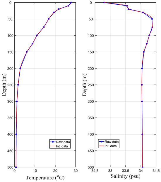
The Korea Oceanographic Data Center (KODC), overseen by the National Institute of Fisheries Science (NIFS), is a pivotal hub for collecting, processing, and disseminating marine science data. By digitizing and subjecting observational data to rigorous quality control, the KODC ensures accurate information in line with international standards. The center actively engages in global partnerships and fosters marine data exchange. A wide array of marine information is provided through the KODC website, including observational metadata, coastal oceanographic data, real-time buoy records, and fishery environmental data. Coastal oceanographic observational data from 207 stations across various sea regions have been collected biannually since 1961. This dataset covers 14 standard water depths; includes essential parameters, such as temperature, salinity, nutrients, and pH; serves as the foundation for news, reports, and analyses by the NIFS; and is widely employed to study seasonal and regional marine variations, with researchers supplementing the limited data for comprehensive insights. The dataset offers information for each water depth at a 1 m interval over 1980–2022, facilitating research across disciplines. Data processing, including interpolation and quality control, is based on MATLAB. These data are classified by region and accessible online; hence, researchers can easily explore spatiotemporal trends in marine environments.
Full article

Figure 1