

Geotechnologies for Agriculture and Soil & Food Security
A special issue of AgriEngineering (ISSN 2624-7402).
Deadline for manuscript submissions: closed (1 June 2023) | Viewed by 4920
Special Issue Editors

Interests: pedometrics; digital soil mapping; soil spectroscopy; machine learning; soil monitoring; soil quality

Interests: digital soil mapping; machine learning; pedology; remote sensing
Special Issues, Collections and Topics in MDPI journals
Special Issue Information
Dear Colleagues,
Global agricultural land areas comprise nearly 50 million ha (or 38% of the world's land area). These surfaces are usually used as cropland (33%) and pastureland (66%) (available at: https://ourworldindata.org/grapher/agricultural-area-per-capita?tab=map&time=2018).
As the world's population continues to grow, the demand for food is also increasing with the same intensity. The pressure on soil, which is a limited resource, is also growing. Global cropland area per capita decreased continuously over the period between 1961 and 2018, from nearly 0.45 ha/person in 1961 to 0.21 ha/person in 2018. This means that agricultural land per person halved and the pressure on the soil twice (available at: https://ourworldindata.org/grapher/agricultural-area-per-capita).
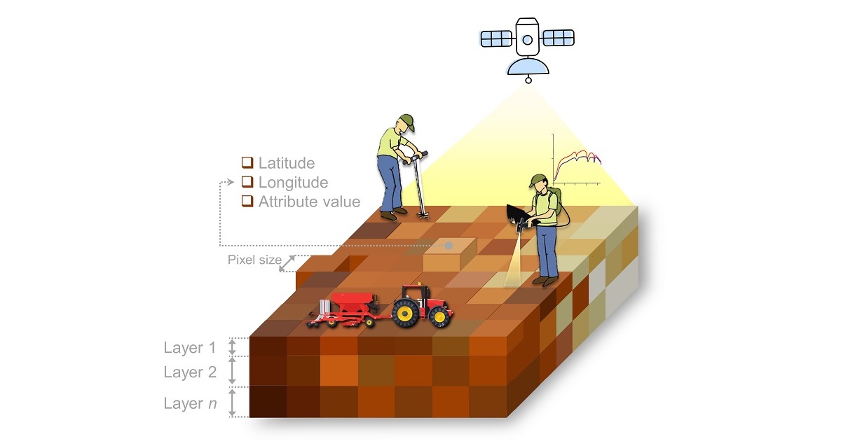
Given that soil plays an important role in food production and climate regulation, we need solutions to preserve and/or restore its quality. These technologies must view soils as a complex body that functions with various constituents that vary over space and time. The n-dimensional products generated by these geotechnologies should be made available to end-users to support their decisions and policy making.
In the last decade, remote and proximal sensed soil data coupled with pedometric techniques including data science and cloud computing, provide new ways to produce and make available n-dimensional soil information at several cartographic scales or spatial resolutions and geographical extents. The adoption of these technological products has proven to be useful in supporting several global goals, especially for increasing sustainable food production and water conservation. However, to meet the food demands of the present and near future, scientists must also turn their attention to the subsoil.
Therefore, we propose the following topics for this Special Issue:
- Remote monitoring of bare soils and natural surfaces for its security;
- Surface reflectance of soils and vegetation to estimate top/subsoil water and productivity;
- Land surface temperature of soils and vegetation to estimate top/subsoil water and productivity;
- Pedometric mapping of top/subsoils and its relationships with productivity;
- Precise maps of top/subsoil attributes: physical, chemical, biological, mineralogical and color;
- Strategies for n-dimensional mapping of soil quality;
- Strategies for pedometric mapping of soil depth;
- Historical, present and future soil carbon storage maps;
- Soil productivity mapping based on soil maps and crop growth simulation models;
- Monitoring soil degradation (e.g., erosion, compaction, pollution) in agricultural lands;
- Web services and geoportals of soil maps and geospatial products for end-users.
We are confident that your contribution of high scientific quality will be a solid reference for the scientific and professional community to produce accurate and useful geospatial products for global agriculture.
Prof. Dr. Raul Roberto Poppiel
Dr. Ruhollah Taghizadeh-Mehrjardi
Guest Editors
Manuscript Submission Information
Manuscripts should be submitted online at www.mdpi.com by registering and logging in to this website. Once you are registered, click here to go to the submission form. Manuscripts can be submitted until the deadline. All submissions that pass pre-check are peer-reviewed. Accepted papers will be published continuously in the journal (as soon as accepted) and will be listed together on the special issue website. Research articles, review articles as well as short communications are invited. For planned papers, a title and short abstract (about 100 words) can be sent to the Editorial Office for announcement on this website.
Submitted manuscripts should not have been published previously, nor be under consideration for publication elsewhere (except conference proceedings papers). All manuscripts are thoroughly refereed through a single-blind peer-review process. A guide for authors and other relevant information for submission of manuscripts is available on the Instructions for Authors page. AgriEngineering is an international peer-reviewed open access quarterly journal published by MDPI.
Please visit the Instructions for Authors page before submitting a manuscript. The Article Processing Charge (APC) for publication in this open access journal is 1600 CHF (Swiss Francs). Submitted papers should be well formatted and use good English. Authors may use MDPI's English editing service prior to publication or during author revisions.
Keywords
- artificial intelligence
- big data analytics
- cloud computing
- deep learning
- digital agriculture
- GIS applications
- n-dimensional maps
- pedometrics
- soil productivity
- soil quality
- subsoil
- unmanned aerial systems
- web services
- yield prediction