

Frequency and Intensity of Landfalling Tropical Cyclones in East Asia: Past Variations and Future Projections

1
School of Energy and Environment, City University of Hong Kong, Hong Kong, China
2
Shanghai Typhoon Institute, China Meteorological Administration, Shanghai 200030, China
3
Asia-Pacific Typhoon Collaborative Research Center, Shanghai 201306, China
Meteorology 2023, 2(2), 171-190; https://doi.org/10.3390/meteorology2020012
Submission received: 17 November 2022
/
Revised: 2 February 2023
/
Accepted: 25 March 2023
/
Published: 3 April 2023
Abstract
:This paper presents the latest analyses and integrates results of many past studies on the spatial and temporal variations of the annual frequency and intensity of tropical cyclones (TCs) making landfall along different areas of the East Asian (EA) coast. Future projections of such variations based on the past investigations are also presented. No statistically significant trend in the number of landfalling TCs could be identified in most of the EA coastal regions, except for an increasing one in Vietnam and a decreasing one in South China. Multi-decadal as well as interannual variations in the frequency of landfalling TCs are prevalent in almost all the EA coastal regions. Only TCs making landfall in Vietnam and the Korean Peninsula showed an increase in landfall intensity, with no trend in the other regions. Nevertheless, more intense landfalling TCs were evident in most regions during the past two decades. Multidecadal variations were not observed in some regions although interannual variations remained large. Various oscillations in the atmospheric circulation and the ocean conditions can largely explain the observed changes in the frequency and intensity of landfalling TCs in different regions of the EA coast. In the future, most climate models project a decrease in the number of TCs making landfall but an increase in the intensity of these TCs in all the EA coastal regions, especially for the most intense ones.
1. Introduction
Climatologically, among all ocean basins where tropical cyclones (TCs) occur, the western North Pacific (WNP) has the highest annual number of TCs of around 27, with about half or more of these TCs making landfall in some part of the East Asia (EA) coast (from Japan in the north to Vietnam and the Philippines in the south, see Section 3 below). Along this long coastline, many large cities and city clusters exist. Any TC making landfall in or near such cities will likely lead to loss of life and destruction of property and infrastructure. Identifying the spatial and temporal characteristics of these landfalling TCs is therefore important for disaster preparedness. For this reason, many investigations have been made to study such characteristics for different parts of EA. This review paper attempts to summarize the major results from these previous studies to provide a comprehensive view of the variations of these characteristics along different sections of the EA coast and the entire area. In addition, the most recent data (up to the year 2020) are included to augment the earlier conclusions. The focus is mainly on the frequency and intensity variations on interannual to multidecadal time scales. In recent years, efforts have also been devoted to examining whether anthropogenic climate change in the future might modify such characteristics. Projections on possible changes in these characteristics under global warming will therefore be summarized.
The data and methodology are described in Section 2. Section 3 gives the climatology of landfalling TCs in various parts of EA, including the frequency and average intensity. The time variations in various characteristics of these landfalling TCs in each part of EA are then presented in Section 4. The possible causes of such variations are discussed in Section 5. How such variations might change under climate change is described in Section 6. The review concludes in Section 7 with a discussion on outstanding issues related to the variations of the landfall characteristics.
2. Data and Methodology
As mentioned in the Introduction, the interannual and interdecadal variations in TC activity are updated to 2020 (see Section 4 and Table 1 below) using data from two best-track datasets, that of the China Meteorological Administration (CMA) for TCs making landfall in China for the period 1949–2019, and that of the Joint Typhoon Warning Center (JTWC) for all other regions for 1945–2020. Only TCs with tropical storm intensity (maximum sustained winds ≥ 17 m s−1) at landfall are included.
As the country in which the TC makes landfall is likely to have the largest amount of data, the number of TCs and their intensity at landfall should be the most accurate. This would still be the case even before the satellite era as the country where the TC makes landfall would have many land observations and/or post analyses. The data from CMA are therefore used for TCs making landfall in China. For the other countries, because of the limited data availability in some countries, the JTWC data are employed to maximize the number of years of available data.
All trends examined in this study are tested for statistical significance based on the Student’s t-test. Rodionov [1] proposed a method to search for significant changes in a time series based on the differences in the sequential running means along the time series with a predefined cutoff length based on the Student’s t-test. If the difference in the two means is significant at a certain confidence level, then a regime shift is defined. This approach is adopted here to identify possible change points on the interdecadal time scale in the TC activity time series. A 10-year threshold is used with a statistically significance of 95%.
3. Climatology
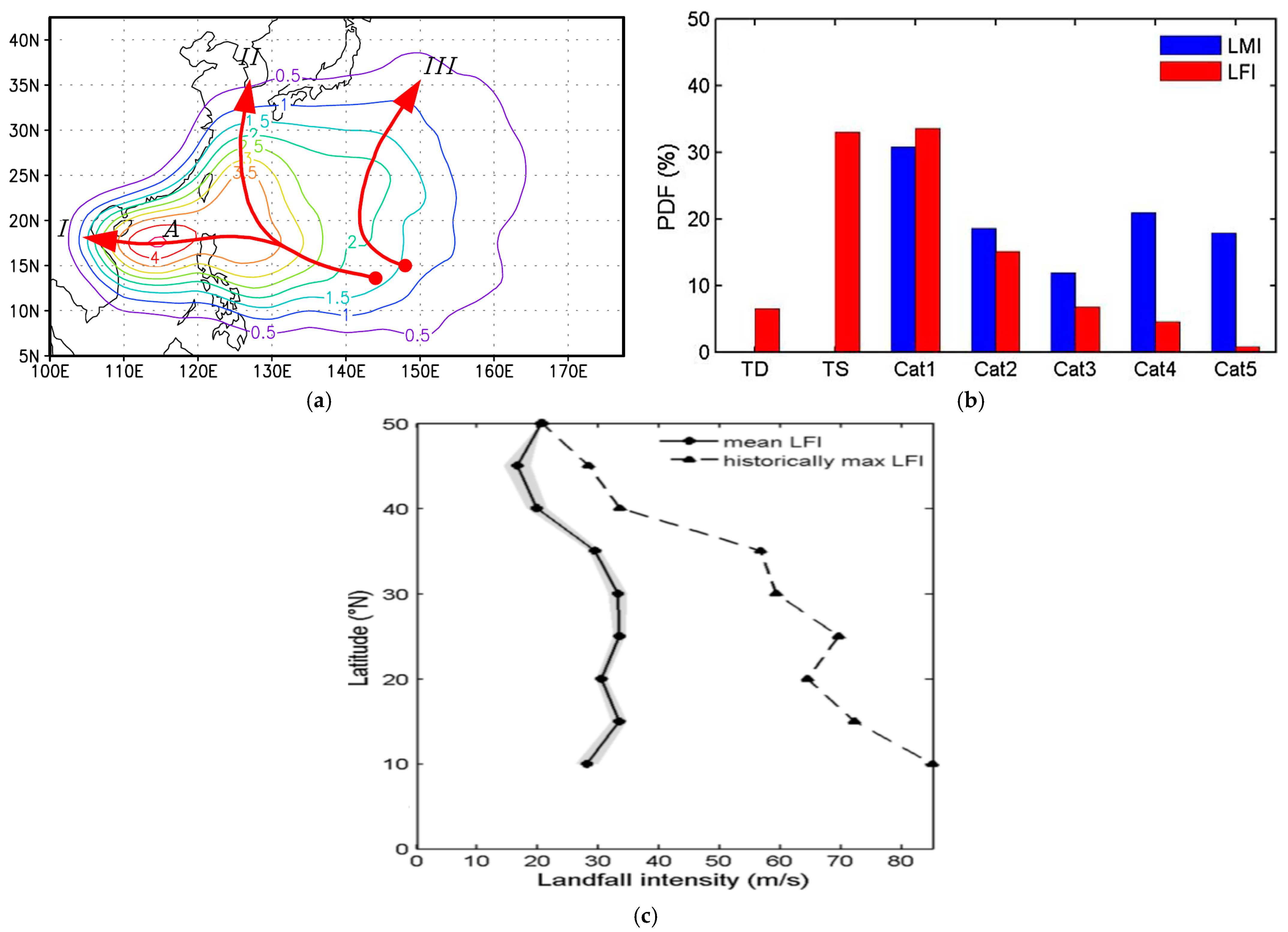
The climatological distribution of TC occurrence frequency during the main TC season (June to October) in the WNP (Figure 1a) shows two main pathways for TCs to make landfall in East Asia: westward-moving TCs making landfall in the Philippines, Vietnam, and South China, and northward-moving TCs making landfall in East China, the Korean Peninsula, and Japan (Wu et al. [2]). On the average, the number of landfalling TCs decreased from south to north, with more than 10 in Vietnam, the Philippines, and South China together, about 4 in East China, and 2–3 in the north (Korean Peninsula and Japan) (Table 1). Guan et al. [3] also found a similar meridional distribution in the number of landfalling typhoons (Category 1 or above on the Saffir–Simpson scale, https://www.nhc.noaa.gov/aboutsshws.php (accessed on 17 November 2022); hereafter, TC intensities are all described using this scale unless otherwise stated) (not shown).
In terms of intensity, Guan et al. [3] suggested that of all the TCs with lifetime maximum intensity (LMI) reaching Category 1 or above that finally made landfall along the EA coast, 40% weakened to either tropical depressions or tropical storms at landfall (Figure 1b). Only 5% of the TCs that made landfall had Category 4 or 5 intensity. While the average landfall intensity (LFI) did not have a large latitudinal variation (Figure 1c), the maximum LFI during the study period (1974–2013) was much larger at lower latitudes.
Because the LFI can vary significantly even during a particular year, Liu and Chan [4] proposed to use the annual power dissipation index (APDI) as a measure of the average intensity impact on a particular region. The power dissipation index (PDI) is defined as the cube of the maximum sustained wind speed at landfall for each TC and the APDI is then the sum of the PDI of all landfalling TCs in that region in a particular year. As such, the APDI depends on both the number of landfalling TCs and their intensities at landfall, and the value will be biased towards the intense landfalling TCs, which will be useful in terms of disaster preparedness. Based on this definition, the values of APDI for all landfalling TCs in each region along the EA coast were calculated (Table 1). Similar to the number of landfalling TCs, the APDI also decreased from south to north, being more than 300 in the Philippines and less than 50 in East China, which is consistent with the latitudinal LFI variations found by Guan et al. [3]. Note also the relatively high value of APDI for Japan, which is due to the small number of TCs making landfall there, although a few of these were quite intense—see Section 4.2 for more details.
4. Temporal Variations of Landfalling TCs
Changes in the large-scale conditions at interannual to interdecadal time scales will lead to concomitant changes in the locations and intensities of TCs making landfall along the EA coast. In this section, the frequency variations are first presented, followed by those in intensity. Possible trends in these two parameters are also investigated.
4.1. Frequency of Landfall
4.1.1. Entire EA Coast
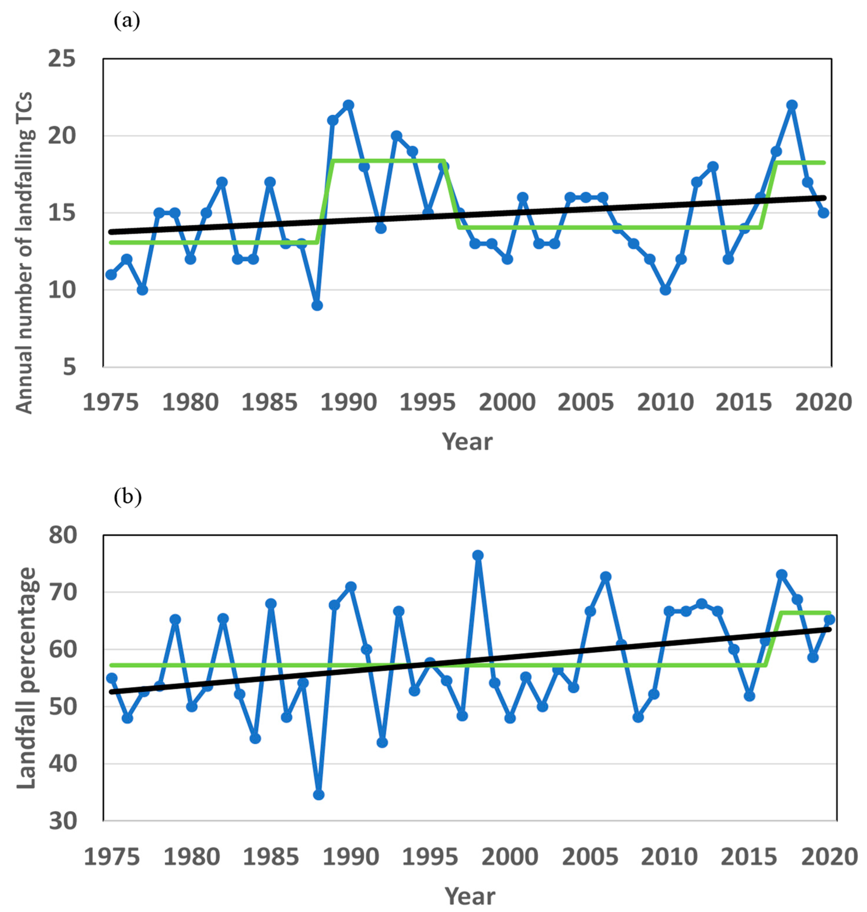
The total number of landfalling TCs along the EA coast undergoes large interannual to interdecadal variations (Figure 2a). The highest number was 22 in 1990 and 2018, and the lowest was 9 in 1988. The change-point analysis shows two high (1989–1996 and 2017–2020) and two low (1975–1988 and 1997–2016) periods. Note that this analysis starts in 1975 instead of from 1945–1949 because the percentage of landfalling TCs relative to the total number of TCs in the WNP is to be examined (see next paragraph), and data for the latter are more reliable after 1975 when routine satellite reconnaissance became available. The linear trend in Figure 2a has only a statistical significance of 84%. Guan et al. [3] also reached a similar conclusion for the number of landfalling typhoons.
Because all these landfalling TCs form over the WNP, their annual number will depend on the total number of TCs occurring over the entire WNP. It is therefore useful to examine the percentage of all TCs over the WNP that eventually make landfall in one of the coastal regions. The percentage of landfalling TCs also showed a large interannual but no interdecadal variability (Figure 2b). Note that the increase in the number of landfalling TCs in Figure 2a during the 1990s does not show up in the percentage of landfalling TCs in Figure 2b. This is because during this period, the total number of TCs in the WNP also had a peak (see e.g., Liu and Chan [5]). On the other hand, the percentage of landfalling TCs showed a statistically significant (at 98%) upward trend of ~2.4% per 10 years, together with a “jump” in 2017. However, because of the short period (2017–2020), whether this jump is real needs to be evaluated in the future. Nevertheless, the result in Figure 2b shows that in recent years, about two-thirds of TCs over the WNP made landfall while in the 1970s, the percentage was only around 50%. A similar statistically significant upward trend for TCs with at least typhoon intensity was also found by Guan et al. [3] for the period 1974–2013.
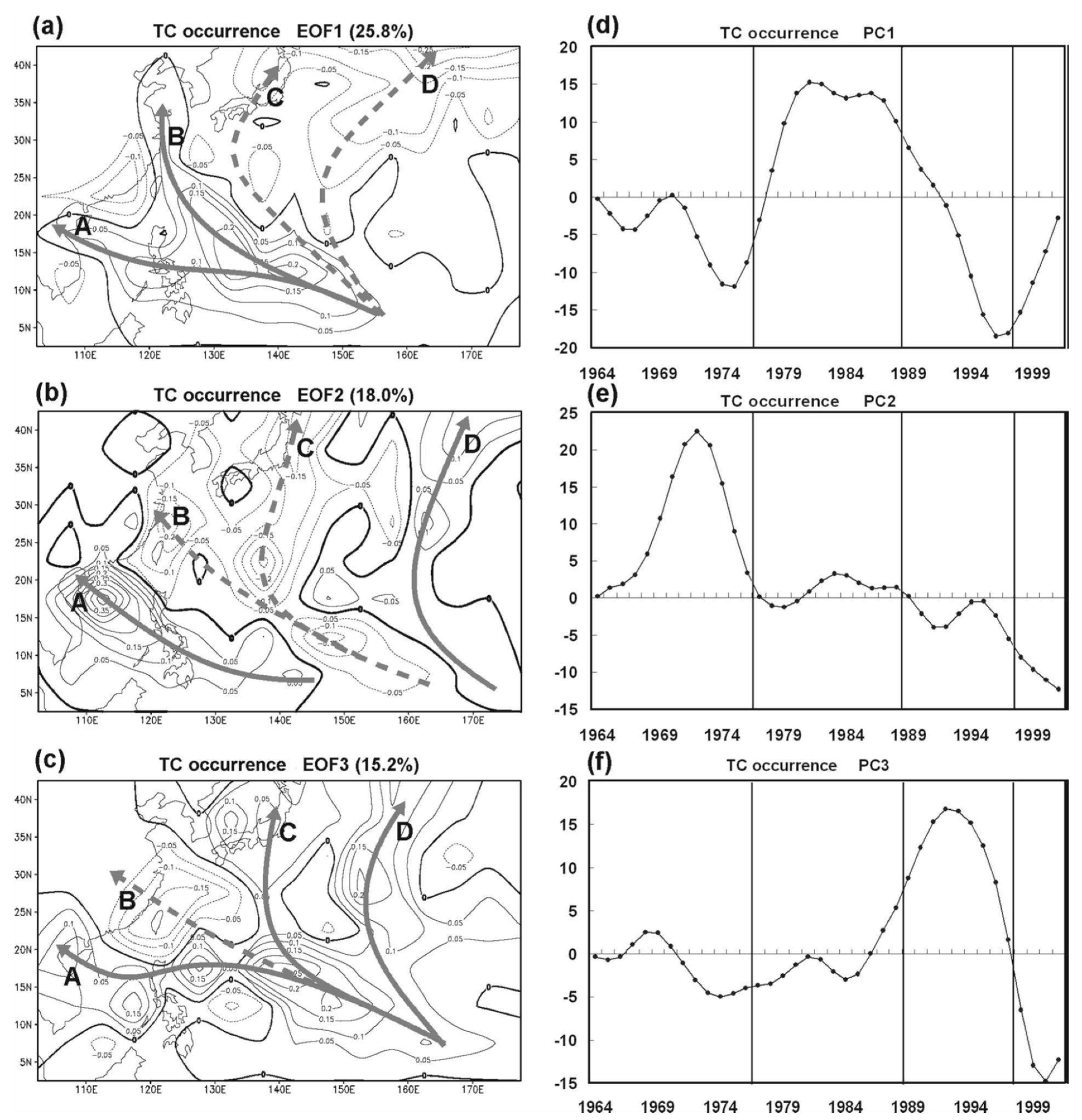
Liu and Chan [6] performed an empirical orthogonal function (EOF) analysis of the 10-year Gaussian-filtered TC occurrence patterns during 1960–2005 over the WNP and found large decadal variations in the prevailing tracks (Figure 3). Based on the principal component (PC) coefficients of the three EOFs, they divided the data period into four subperiods: 1964–1976, 1977–1988, 1989–1997, and 1998–2005. It is apparent that combining the PC coefficients (Figure 3d–f) and the track occurrence (Figure 3a–c), more TCs made landfall in South China, Vietnam, and the Philippines, and fewer in East China, the Korean Peninsula, and Japan during the first two periods. More landfalling TCs occurred in Period 3 in northern Vietnam and Japan. In Period 4, the entire landfall pattern shifted northward, with more TCs making landfall in East China, the Korean Peninsula, and Japan, and fewer in the southern part (South China, Vietnam, and the Philippines). Interannual and interdecadal variations in the frequency of landfalling TCs in different regions along the EA coast have also been found by Chan and Xu [7], who examined these frequencies for the period 1945–2004. More discussion on the temporal variations in each region will be presented below.
4.1.2. China Coast
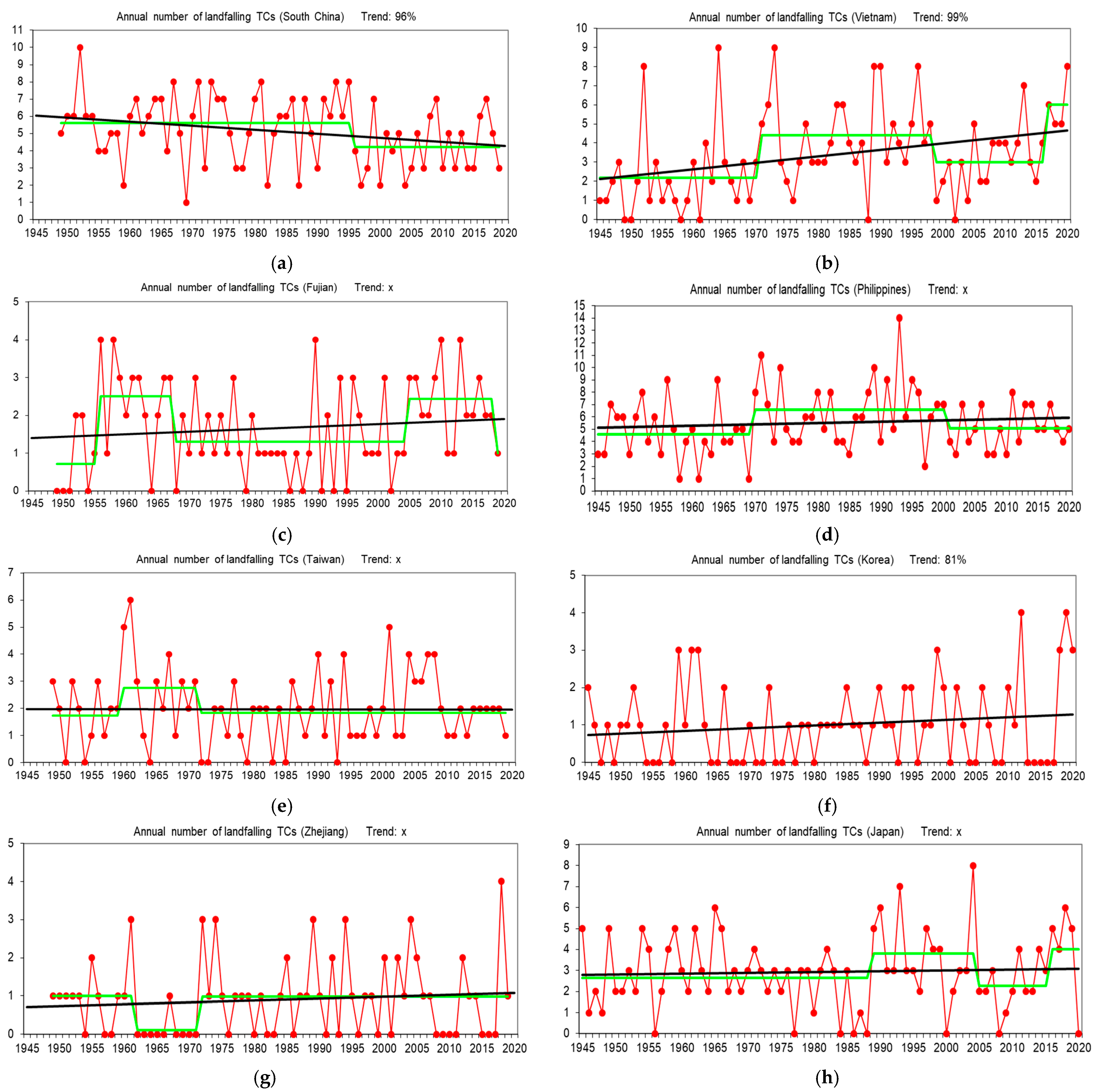
The China coast has the largest number of landfalling TCs in the EA region. The average number of TCs making landfall along the South China coast (Guangdong, Guangxi and Hainan provinces) is ~5 while that along the East China coast (Fujian, Zhejiang, and Shanghai municipality) is ~3 (those making landfall more than once is counted as one) and ~2 for Taiwan Island (see Figure A1 for the various provinces and regions). None of the regions shows a statistically significant trend in the number of landfalling TCs (Figure 4c,e,g) except for South China, which has a decreasing trend, with a 96% confidence level, and an abrupt change in 1996 (Figure 4a). A similar result was obtained earlier by Liu and Chan [5], which differs from a later study by Liu and Chan [8], who found that the frequency of landfalling TCs increased after 2008. An earlier study by Li et al. [9] for the period 1975–2014 found an increase in the frequency of TCs making landfall in East China in recent decades but no trend can be identified for TCs landfalling in South China. Note, however, that the Li et al. [9] study defined “East China” and “South China” using the latitude of 25° N so that the comparisons may not be appropriate. Indeed, the differing conclusions from the various studies are likely due to the length of the data period, the seasons (whole year versus peak season, for example), the definition of the regions, and the datasets used.
Other than the trend, all the time series of the number of landfalling TCs along the different subregions of the China coast show large interannual and interdecadal variations. However, the phases of the interdecadal variations in different subregions are different. In South China, a decrease has occurred since 1996. Both Fujian and Taiwan show an increase in the 1960s during which almost no TC made landfall in Zhejiang. Another high period occurs in Fujian from 2005 to 2018.
As most TCs making landfall along the China coast are within 20–30° N, Zhang et al. [10] examined landfalling TCs within this latitude band for the period 1979–2015 and found a slight though statistically insignificant increase in the number of such TCs. Because they did not separate those that make landfall in south China versus those in eastern China, it is difficult to compare the results with those of the previous studies.
Recently, Shan and Yu [11] showed that the changes in landfall frequencies in East and South China occur at different times of the year. The decrease in South China mainly occurs in the late season (October to December) due to the decrease in westward TCs, while the increase in East China results from an increase in the peak TC season (July to September).
4.1.3. Vietnam
The number of TCs making landfall along the Vietnam coast has a statistically significant upward trend, with a confidence level of 99% (Figure 4b), together with a large interdecadal variation. The landfall frequency has two low (1945–1970, 1999–2016) and two high (1971–1998, and since 2017) periods. Tran-Quang et al. [12] examined the frequency of TC occurrence over the South China Sea and found a significant increase during the period 1995–2014 compared with 1975–1994. However, these TCs may make landfall in South China rather than Vietnam, or even move eastward to make landfall in the Philippines. It is therefore difficult to compare Figure 4b with the results from Tran-Quang et al. [12].
4.1.4. Philippines
The number of TCs making landfall in the Philippines has no statistically significant trend but an interdecadal variation, with a higher landfall frequency during 1970–2000 but lower in the other years (Figure 4d). Kubota and Chan [13], who extended the landfall data back to 1902 using archives from the monthly bulletins of the Philippine Weather Bureau, also found interdecadal variations with a similar periodicity of 20–30 years. Cinco et al. [14] showed that during 1951–2013, an annual average of around nine TCs made landfall in the Philippines, with a large interdecadal variation and a slight but insignificant downward trend. Again, the annual average depends strongly on the averaging period and the dataset used.
4.1.5. Korean Peninsula
No statistically significant interdecadal variation in the number of TCs making landfall over the Korean Peninsula can be identified (Figure 4f). This is in contrast with an earlier study by Choi et al. [15], who found alternate high- and low-frequency periods. This discrepancy likely arises from the different seasons used in their study and our analysis here. Choi et al. [15] only examined the landfalling TCs in July to September and for the period 1951–2004, while the data in Figure 4f are for all months and for a longer period (1945–2020). Choi and Moon [16] also found similar interdecadal variation in the frequency of TCs that “affected” Korea, although they considered a much large area that included both the East China Sea and western Japan. They also found more TCs making landfall on the west coast of the Korean Peninsula during 2005–2010 but more on the southern coast during 1999–2004. Extending the data to 2020 as in Figure 4f shows a slight increasing trend (significant only at 81%).
4.1.6. Japan
Similar to most other regions, the number of TCs making landfall in Japan has a large interdecadal variation, with two high (1989–2004 and since 2016) and two low (1945–1988 and 2005–2015) periods but no statistically significant trend (Figure 4h). Grossman et al. [17] examined TCs in zones around Japan during 1951–2011 and found that while no significant trend existed, the number of TCs making landfall along the Pacific coast of the Japan islands appears to have increased since 1980. Yamaguchi and Maeda [18] also obtained a similar result based on TCs approaching Tokyo. Even when combining the TC landfall numbers for Japan and Korea, Park et al. [19] and Goh and Chan [20] could not identify any statistically significant trend, although Park et al. [19] identified a significant increase in the 1990s but a decrease in the late 1990s. More importantly, they found a statistically significant increase in the ratio of the number of TCs making landfall in Korea and Japan to the total number of TCs occurring in the WNP during the entire data period (1977–2008). This increase is consistent with the result in Figure 2b.
4.1.7. Summary
Two main conclusions can be drawn from the analyses presented in Figure 4 and the results from previous studies. One is that in terms of temporal trends, only Vietnam had an increasing trend and the South China coast a decreasing one. All other regions do not have any statistically significant trend. Second, for almost all regions along the EA coast, the number of landfalling TCs has had large interannual as well as interdecadal variations. While the phases of the interdecadal variations (some of which are statistically significant) are different for different regions, the results from Figure 4 and those from previous studies are consistent in showing the existence of an apparent northward shift in the frequency of landfalling TCs in the past 60–70 years. That is, in the southern part, the number of landfalling TCs was high in the 1960s and 1970s, but has decreased in the recent decade. The opposite is true for the northern part (Japan, Korea, and East China) where more TCs have made landfall during the past decade. Possible reasons for this northward shift will be discussed in Section 4 and Section 5, one of which may be related to global warming and a subsequent shift in the position of the subtropical high (e.g., Kossin et al. [21]).
To investigate whether such a northward shift has occurred before, Liu et al. [22] examined historical documents from Japan and China back to 1910 and showed that when the number of TCs occurring near the South China coast (which therefore likely make landfall in one of the southern regions—South China, Vietnam, and the Philippines) is high, that in the area south of Japan (likely making landfall in Japan) tends to be low, and vice versa. This suggests that the recent increase in the number of TC landfalls in the north may simply be a north–south oscillation rather than a continuous northward shift.
4.2. Intensity
4.2.1. Entire EA Coast
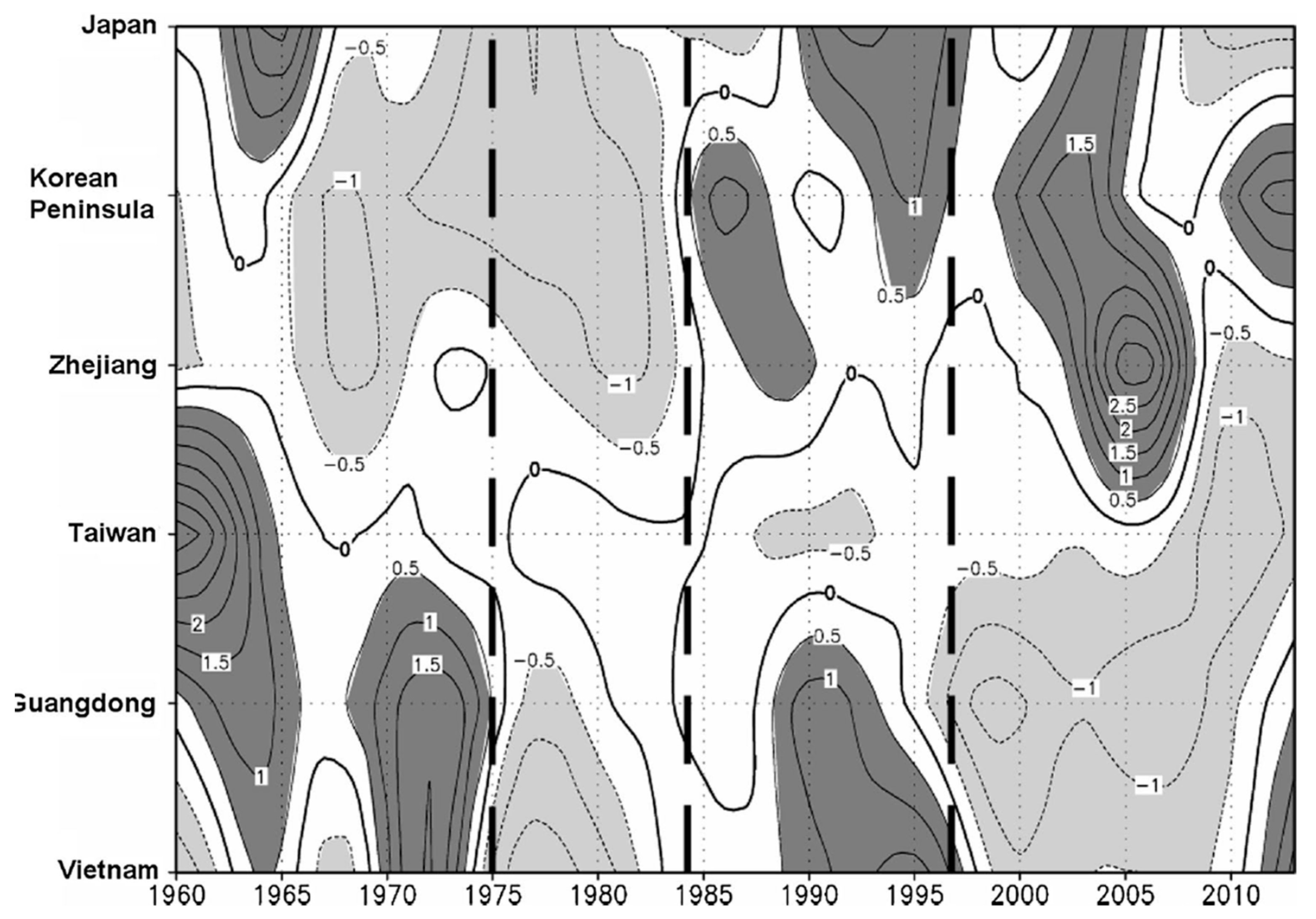
Liu and Chan [4] examined the anomalies of APDI along the EA coast for the period 1960–2013 and found positive anomalies in the south (South China, Vietnam) and negative in the north (East China, Korean Peninsula, and Japan) during 1960–1974, but the opposite situation occurs after 1997 (Figure 5). Between 1975 and 1997, negative and positive APDI anomalies were found all along the EA coast during 1975–1984 and 1985–1997 respectively. The northward shift in APDI distribution is consistent with an earlier study by Wu et al. [2], who found that the intensity of the TCs at landfall only increased significantly in the northern part of the EA coast (mainly in East China, Korea, and Japan), although they did not find any obvious change in the southern part (Vietnam, South China).
This change in APDI is likely related to where the TCs reach their maximum intensity. Park et al. [23] found a significant shift in the location of the LMI of TCs towards the EA coast all the way from Vietnam to Japan during 1977–2010. Mei and Xie [24] examined two clusters of TCs, one of those making landfall in South China and one in East China, the Korean Peninsula, and Japan. They found that both clusters of TCs tended to become more intense in later years, which is influenced by an increase in the intensification rate. They then concluded that the intensity of landfalling TCs therefore is likely to have increased with time. A later study by Liu and Chan [25] showed that the area where most TCs reach Category 4 and 5 intensity shifted significantly northwestward from its climatological location during the period 2002–2016. Most of these intense typhoons undergo rapid intensification (RI, maximum sustained winds increasing by 30 kt or more within 24 h). Liu and Chan [26] further found that the locations of genesis of these RI TCs as well as their LMI also exhibited a similar shift. A recent study by Li et al. [27] again found a shift of the LMI of all TCs making landfall in China. In other words, the mean locations of genesis, RI, and LMI have all moved closer to the EA coast in recent years, which would suggest an increase in the mean intensity and also the PDI of the TCs when they make landfall, which is indeed the case (Guan et al. [3]).
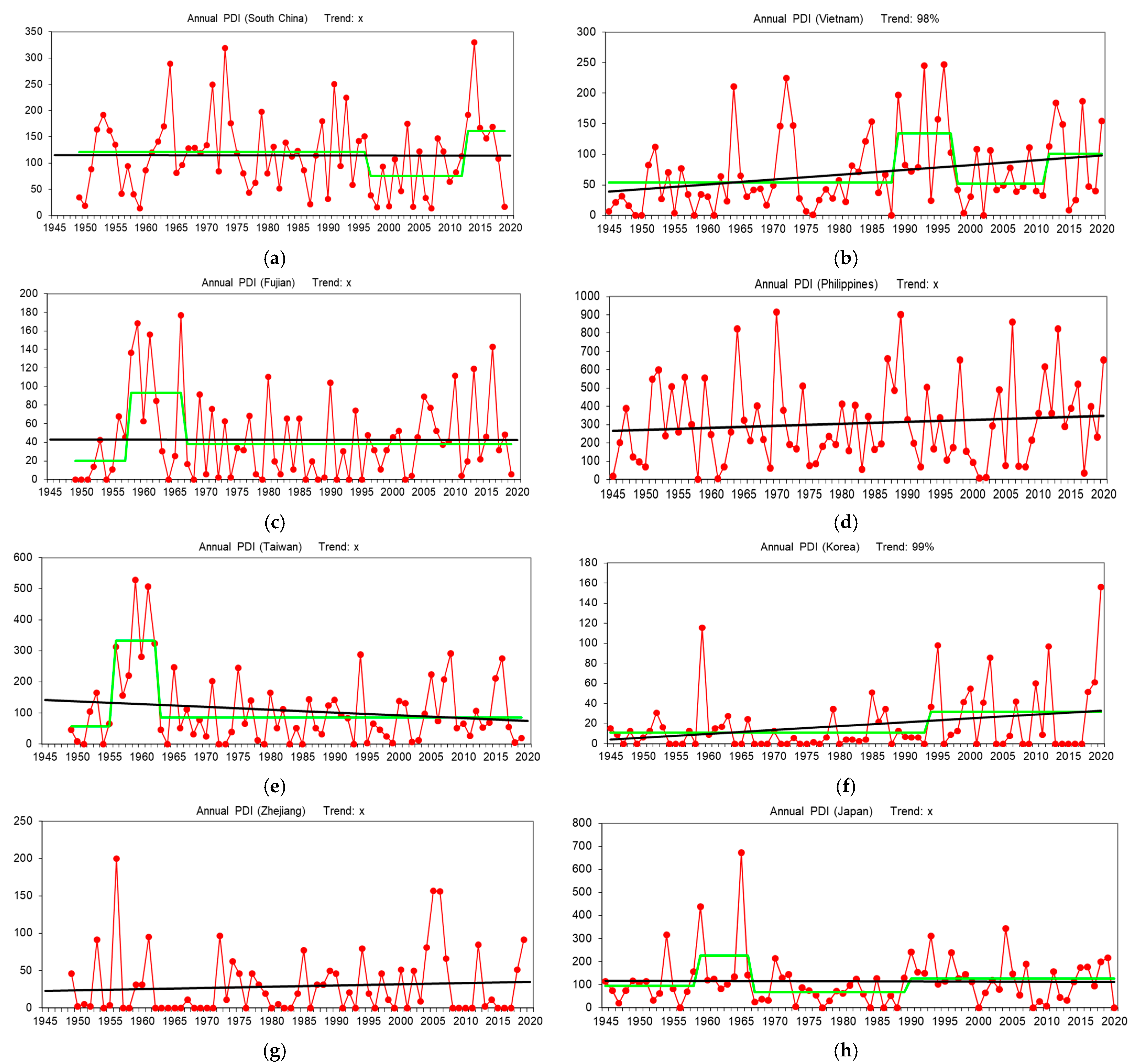
To investigate the possible trends and periodicities in the landfall intensity along the EA coast, the variations in APDI in each of the coastal regions were examined. The results are presented in Figure 6 and discussed below.
4.2.2. China Coast
While some of the previous studies have suggested a possible increasing trend in landfall intensity during a certain period, an examination of the long-period data from 1949–2019 does not suggest any statistically significant trend in APDI in any of the subregions along the China coast (Figure 6a,c,e,g). However, the APDI shows a significant decrease during the period 1997–2012 in South China (Figure 6a). Referring back to Section 4.1.2, a significant decrease in the landfall frequency has also occurred in this region since 1997 (Figure 4a). Thus, the decrease in APDI in South China is mainly due to the decrease in the number of TCs making landfall there rather than the intensity. However, after 2012, APDI shows a significant jump, which implies that those TCs making landfall over South China have become more intense, which is the conclusion of Liu and Chan [28], who found an increasing number of intense landfalling typhoons in South China in recent years.
Li et al. [9] identified a significant increase in the average PDI along the China coast north of 25° N during 1975–2014, which is influenced by both an increase in the landfall frequency and the landfall intensity. A later study by Liu et al. [29] also shows a similar increase in APDI for the entire coast of mainland China for the period 1980–2018, with most of the increase for TCs making landfall north of 27° N. Contrary to the results of Li et al. [9], Liu et al. [29] suggested that such an increase is mainly related to the increased duration over land and a slight increase in average intensity. However, an extension of the time series to include a longer period, 1949–2020 (Figure 6c,e,g), does not show any statistically significant trend in APDI in any of the three regions covered by their study (Fujian, Taiwan, and Zhejiang) although there appears to be a slight though insignificant increase in Zhejiang province (Figure 6g). This apparent discrepancy is due to the relative high values of APDI in the 1950s in Fujian and Zhejiang, thus reducing the significance of the increasing trend shown in Li et al. [9].
It should also be noted that while the interannual variation of APDI is quite large, the change-point analysis in Figure 6c,e,g cannot identify any significant interdecadal variation except for a significant increase in APDI in Fujian and Taiwan in the 1950s and 1960s.
4.2.3. Vietnam
The APDI time series for Vietnam shows a statistically significant increase with time (confidence level: 98%; Figure 6b). Substantial interdecadal variations also exist, with higher values during 1989–1997 and since 2012. The latter increase in APDI is consistent with that for South China (see last subsection), which is likely due to the increase in intense TCs over the South China Sea as found by Liu and Chan [28]. An earlier study by Tran-Quang et al. [12] also found an increase in the number of strong (maximum intensity > 41 m s−1, or ~147 km h−1) TCs affecting the Vietnam coast (although not necessarily making landfall over Vietnam) during the period 1995–2014 compared with 1975–1994.
4.2.4. Philippines
No statistically significant trend in APDI is found for TCs making landfall in the Philippines (Figure 6d). There is also no significant interdecadal variation. Cinco et al. [14] pointed out that more “extreme typhoons” (maximum intensity > 150 km h−1) have been found in the Philippine Area of Responsibility (PAR) in recent years although the trend is not statistically significant. Furthermore, the number of all typhoons (maximum intensity > 118 km h−1) that have entered the PAR actually decreases with time.
4.2.5. Korean Peninsula and Japan
The APDI time series for the Korean Peninsula shows a statistically significant (at 99% confidence level) increase, with a significant jump occurring in the mid-1990s (Figure 6f). This is consistent with the results of Choi et al. [15], who showed that the ACE of TCs making landfall in Korea is in a “high” period during 1986–2004. It appears that this increase in the intensity of TCs landfalling in Korea continued to 2020.
Combining the landfalling TCs in the Korean Peninsula and Japan, Park et al. [19] found the total PDI for these TCs nearly doubled from the 1977–1988 period to 1997–2008. However, if we focus on Japan alone, no trend in APDI can be found (Figure 6h). It is likely that the result in Park et al. [19] is due to the increasing trend of APDI for TCs landfalling in the Korean Peninsula.
4.2.6. Summary
To summarize, the APDI in most of the regions within the entire EA coast does not show a statistically significant rising trend although some studies did suggest an increase based on a relatively short time period. There also seems to be a shift in the location of anomaly of the APDI from south to north with time. In other words, a higher number of intense TCs have tended to make landfall in East China, the Korean Peninsula, and Japan in recent years but a lower number in the south. For individual regions, only Vietnam and the Korean Peninsula show a statistically significant increase in APDI. For all regions, large interannual variations exist. However, only a few regions display statistically significant interdecadal variations (South China, Fujian, Taiwan, Vietnam, and Japan).
5. Possible Drivers
The temporal variations in the atmospheric and oceanic conditions responsible for the genesis, intensity changes, and movement of the TCs are likely the causes for changes in the TC landfalling frequency and intensity at different locations. This section therefore presents summaries of previous studies that attempt to relate such variations to the landfalling activity in various EA regions, which are often associated with the different phases of various atmospheric and/or oceanic oscillations. As large interannual and interdecadal variations have been identified in Section 3, oscillations in these two time scales will be considered separately.
5.1. Interannual Variations
The El Niño/Southern Oscillation (ENSO) has been shown to be the most important driver of the interannual variations of TC activity in the WNP (Chan [30,31]; Wang and Chan [32]; Lin et al. [33]). Chan [31] and Wang and Chan [32] have shown that during a La Niña year, TCs tend to form further to the west, and hence more TCs are likely making landfall on the EA coast. Indeed, Zhou and Lu [34] found a negative correlation between the frequency of TCs making landfall south of 25° N and the sea-surface temperature (SST) in the eastern equatorial Pacific, which means that more TCs tend to make landfall in the southern region in a La Niña year, which is consistent with the result of Zhang et al. [35]. On the other hand, for El Niño years, TCs tend to form further to the southeast (Chan [31]; Wang and Chan [32]). As a result, they tend to recurve farther from most of the EA coast, and hence fewer TCs tend to make landfall, especially in the late seasons, with the exception of Japan and the Korean Peninsula (Wu et al. [36]; Goh and Chan [20]). However, Ho and Kim [37] suggested that the impact of El Niño is mostly confined to the landfalling frequency in Japan and the impact on the Korean Peninsula is minimal.
Zhang et al. [35] further considered the effects of ENSO on the frequency of EA landfalling TCs for the central Pacific (CP) type of ENSO. During the summer of CP-El Niño years, more TCs likely make landfall over EA, especially over Japan and the Korean Peninsula, because of the anomalously strong easterly flow and a northward shift in the location of TC genesis. This also leads to a reduction of landfall frequency in the southern part of EA. Zhang and Guan [38] also found an increase in landfalling TCs in the northern part of the China coast.
Yonekura and Hall [39] included the effects of ENSO in simulating the TC tracks over the WNP, and showed that such an inclusion improves the prediction of the landfalling frequency.
In addition to ENSO, Gao et al. [40] suggested the SST in the tropical North Atlantic (TNA) as another factor that could impact on the location of genesis and the large-scale flow in the WNP, and thus the landfalling frequency of TCs along the EA coast. The frequency of landfall along the EA coast (except the Philippines) is generally higher when the SST anomalies over the TNA are negative. Gao et al. [41] further showed that an above-normal spring SST in the TNA can trigger a response in the WNP such that more intense TCs are found to make landfall in Mainland China in the autumn.
Wang and Chen [42] also found that the gradient in SST between the tropical Indian Ocean and the WNP bears a relationship with the landfall frequency along the China coast. When this gradient is positive, which means the SST in the Indian Ocean is higher, an anticyclonic anomaly develops in the WNP so that TC genesis is less favorable and hence fewer TCs tend to make landfall in China.
Wang and Chen [43] further related the onset of the South China Sea summer monsoon to the TC landfall frequency in China. They suggested that when this onset is early, the subtropical high tends to retreat northeastwards, allowing the establishment of the monsoon trough near the Philippines. The subsequent strong cyclonic anomaly then allows more TCs to form and make landfall in China.
Choi et al. [44] found a relationship between SST in the East Indian Ocean (EIO) and TCs affecting Korea (the area includes the Korean Peninsula as well as East China). A warm EIO induces anomalous easterlies in the WNP, causing TCs to make landfall in southern EA and thus reducing the number of TCs affecting Korea.
5.2. Interdecadal Variations
Liu and Chan [6] pointed out that the EOF track patterns shown in Figure 2, and hence whether TCs would make landfall, are partly related to the Pacific Decadal Oscillation (PDO, Mantua et al. [45]) and have been related to TC activities in the WNP. The strength and westward extent of the subtropical high are different for different phases of the PDO, and hence the genesis location as well as movement of the TCs will also be different, subsequently the different landfall locations.
For example, Yang et al. [46] examined the interdecadal variation of typhoons (category 1 or above) making landfall along the China coast and found that during the negative phase of the PDO, a cyclonic anomaly exists over the WNP, which leads to an easterly anomaly in the northern part, and thus brings more typhoons to the east coast of China. Both Choi et al. [47] and Choi and Kim [48] pointed out that during positive PDO years, anomalous anticyclonic circulation is prevalent in the low latitudes so that the flow south of the Korean Peninsula is generally northwesterly. The vertical wind shear is also stronger. Thus, fewer TCs tend to make landfall in the Korean Peninsula. Even if TCs approach, they tend to be weaker.
The effect of PDO can also vary under different ENSO conditions. For example, Kubota and Chan [13] found that during negative PDO years, the number of TCs making landfall in the Philippines decreases significantly in an El Niño year but increases in a La Niña year. Such an impact from ENSO, however, is not clear during positive PDO years. Choi and Kim [49] also pointed out that the superposition of the circulations associated with PDO and ENSO can lead to different frequencies of TCs affecting Korea. Furthermore, there seems to be a difference before and after 1981. Before 1981, more TCs tend to affect Korea when both the PDO and ENSO indices are negative, and fewer when both indices are positive. However, after 1981 these relationships are not statistically significant because the circulations have apparently shifted.
The changes in the PDO-related circulation can also alter the location of the LMI of the TCs. Liu and Chan [25] found a statistically significant negative correlation between the PDO index and the average latitude of the LMI. In recent years, the PDO index has been negative, which implies a higher latitude of the LMI, suggesting the increasing chance of higher-intensity TCs making landfall in northern latitudes, including the east coast of China, the Korean Peninsula, and Japan. This northern shift in the average latitude of LMI is consistent with the increase in APDI found in Liu and Chan [4]. The recent increase in APDI and maximum intensity of TCs making landfall in South China (see Section 4.2.2; Liu and Chan [28]) may also be related to the PDO, as Wang et al. [50] found a possible relationship between PDO and the change in the number of RI TCs in the WNP, some of which would move into the South China Sea to make landfall in South China.
Other than the PDO, Gao et al. [51] suggested that the Pacific Meridional Mode (PMM, Chiang and Vimont [52]) can be a useful factor for predicting the frequency of TC landfall in China. During the positive PMM phase, the main TC development region over the WNP has higher low-level cyclonic vorticity and stronger upper-level anticyclonic flow so that more TCs tend to form within the region. With the prevailing easterly flow to the north of the region, these TCs would tend to be steered westward to make landfall along the China coast.
Comparing the number of TCs affecting the south China coast and those affecting Japan, Liu et al. [22] identified the Interdecadal Pacific Oscillation (IPO, Henley et al. [53]) as a possible factor related to the landfalling TC frequency in these two regions. In general, during the period in which the IPO is in its negative phase, there tends to be more TCs making landfall in Japan and fewer in south China because of anticyclonic flow anomalies in the lower troposphere south of 15° N and cyclonic anomalies north of 20° N. However, ENSO again plays a role in modifying this relationship through altering the genesis location.
5.3. Summary
Various atmospheric and oceanic oscillations have been found to be very much related to the interannual and interdecadal variations of the frequency of landfalling TCs along different parts of the EA coast. The different phases of these oscillations correspond to different atmospheric flow conditions that determine the genesis and intensification locations as well as the steering flow, which then lead to the TCs making landfall at different locations. Thus, development of statistical prediction models must consider such oscillations. Whether dynamical models can provide better landfall frequency and intensity predictions depends on how well the models can forecast the phases of these oscillations.
6. Future Projections
While quite a number of studies have presented projections of TC activity over the WNP (see the summary in Knutson et al. [54,55]), not many investigations have been made specifically on the possible changes in the frequency or intensity of landfalling TCs along the EA coast. Because global model projections from the Coupled Model Intercomparison Project Phase 6 (CMIP6, Eyring et al. [56]) have only been recently released, all the projections to be presented here are based on those using results from CMIP5 or other global models prior to the release of CMIP6 results.
Tsuboki et al. [57] performed very high-resolution (~2 km) downscaling experiments using the Japan Meteorological Research Institute (MRI) 20 km mesh atmospheric global circulation model MRI-AGCM3.1 (Mizuta et al. [58]) for the 30 most intense typhoons obtained from the parent model in a future climate with higher SSTs. Twelve of these became supertyphoons (maximum winds > 67 m s−1), with the most intense one reaching 88 m s−1, and half of them moving towards Japan.
To project TC activity in the South China Sea, and mainly focusing on landfalling TCs in Vietnam, Wang et al. [59] used a regional climate model (PRECIS 2.1) to downscale the CMIP5 UK Hadley Centre model under two climate scenarios, RCP4.5 and RCP8.5. They found a decreasing trend in the summer but an increasing trend in the winter due to a change in the large-scale environmental conditions under both scenarios.
Gallo et al. [60] used three regional climate models to project future TC activity within the Philippine Area of Responsibility (PAR), and hence landfalling TCs in the Philippines, with boundary conditions from CMIP5 for the mid-21st century (2035–2064). In general, most models show a decrease in TC activity in this period compared with the present day, with some models projecting more intense TCs.
Lok and Chan [61] ran a regional climate model (RegCM3) using one of the CMIP5 models (the one from the UK Hadley Centre) to define boundary conditions to project TC frequency over the WNP as well as landfalling TC activity along the South China coast for three periods, 2030–2039, 2060–2069, and 2090–2099, under the RCP8.5 climate scenario. They found that the average TC genesis location migrates northward from the first to the third period. Probably because of this, the probability density function (PDF) of the frequency of TCs making landfall along the South China coast shifts towards the low side as the century progresses, which suggests it is likely that fewer TCs will make landfall there. They further followed the approach of Lok and Chan [62] to nest the Weather Research and Forecasting (WRF) model in the RegCM3 projections to project the intensity of these landfalling TCs. They found that the PDF of the APDI of these landfalling TCs actually shifts to the high side, which suggests that while there might be fewer TCs, it is likely that some of these TCs will be more intense than those of the present day.
Kanada et al. [63] ran a high-resolution (4 km), non-hydrostatic cloud-resolving regional model using data from the Policy Decision-Making for Future Climate Change (d4PDF) database (Mizuta et al. [64]) for typhoons that make landfall in Hokkaido, Japan for 4 K climate warming runs. They found that in the future, there would tend to be more TCs with higher intensities making landfall in Hokkaido. Although this study focuses on TCs affecting Hokkaido, the result is consistent with that of Lok and Chan [61] on the apparent northward shift in TC frequency.
Wu et al. [65] conducted a similar study by running the RegCM4 regional model using boundary conditions from five different CMIP5 models to project the frequency of TCs making landfall in various provinces in China under the RCP4.5 scenario. Based on the ensemble average of the five models, they found a general increase in the frequency of TC landfall towards the end of the 21st century, although the differences between the future projections and the present-day results do not appear to be significant.
Although not directly focusing on the future landfall frequency, Hsu et al. [66] identified TC-like vortices from the projections of future climate under the RCP8.5 scenario from two high-resolution global climate models for three regions close to the EA coast: the Taiwan–East China region, the South China–Indochina region, and the region around Japan, similar to the division made by Chan and Xu [7]. They found that for all the regions, the TC frequency decreased by almost 50%, which is largely attributed to a decrease in the genesis of TCs over the WNP. However, the PDI values in these regions all increased.
The results of these different studies appear to be quite consistent with one another. That is, for almost all the EA coastal regions, the number of landfalling TCs may be on the decrease. However, the TCs that make landfall can be more intense than those in the present climate.
7. Summary and Discussion
7.1. Summary
This paper presents analyses of the latest data and a summary of previous studies on the historical spatial and temporal variations of tropical cyclones (TCs) making landfall along the East Asian (EA) coast, including the annual frequency and intensity. Future projections of such variations are also presented. The major results are summarized in Table 2 and Table 3.
In terms of the annual frequency, with the exception of an increasing trend in the number of landfalling TCs in Vietnam and a decreasing one in South China, no statistically significant trend can be identified in any of the other regions along the EA coast. While no trend is apparent, all studies point to a northward migration in the frequency of landfalling TCs, with more in the south and fewer in the north in the last half of the 20th century but the opposite in the 21st century. However, such a migration might simply be a north–south oscillation as a higher frequency of landfalling TCs and a concomitant lower frequency can be identified near Japan and the South China Sea, respectively, in the early part of the 20th century. Multidecadal, as well as interannual, variations in the frequency of landfalling TCs were found in almost all the regions along the EA coast.
The intensity of TCs making landfall along the EA coast also does not show any statistically significant trend with the exception of for Vietnam and the Korean Peninsula, both having an increasing trend. A northward migration similar to the frequency of landfalling TCs can also be found in the intensity during the past 70 years. Interannual variations remain large in the intensity time series in all regions, but only some regions show a statistically significant multidecadal variation.
Variations in the atmospheric circulation and the ocean conditions are the main driving factors for the observed changes in the frequency and intensity of landfalling TCs in different regions of the EA coast through modifications of the environmental conditions that control the genesis, intensification and tracks of the TCs. On the interannual time scale, the most important factor is the El Niño/Southern Oscillation (ENSO). Both the Eastern Pacific and Central Pacific ENSO have been shown to have an effect. In addition to ENSO, such interannual variations have also been linked to sea-surface temperatures in the North Atlantic and the Indian Ocean. On decadal and multi-decadal time scales, a number of oscillations have been identified, which include the Interdecadal Pacific Oscillation (IPO), the Pacific Decadal Oscillation (PDO), and the Pacific Meridional Mode (PMM). Some studies have found that these oscillations can “couple” with those on interannual time scales to produce the observed variations.
As these oscillations will likely change under climate change, studies have also been made to project future changes in the frequency and intensity of landfalling TCs in the EA coastal regions. Most of the results suggest that in the future, the number of TCs making landfall in all the regions tends to decrease. On the other hand, all studies project the intensity of these TCs to increase, especially for the most intense ones.
7.2. Discussion
The purpose of this study and review is to provide the meteorological community and those in disaster preparedness to have a better appreciation of the variations in both the frequency and intensity of TCs making landfall along different EA regions. Such knowledge is essential especially in future planning of disaster mitigation measures. In particular, most of the studies have projected an increase in the intensity of such TCs in all the regions. This result poses a great challenge not only to governments but also to the private sector in preparing for the likely increase in damage to buildings, infrastructure, agriculture and people’s livelihood, especially in view of the continued increase in population along the EA coast and the expected increase in global warming.
While this review provides a historical perspective, it is also important to project what might happen in the future. Section 5 has summarized some of the projection studies based on CMIP5 models. With the availability of CMIP6 models (Eyring et al. [56]), future studies should downscale these model projections to estimate the possible changes in the frequency and intensity of TCs making landfall in different coastal regions. In addition to statistical downscaling, attempts should be made to perform dynamical downscaling using coupled models especially in projecting future intensity changes. Other than frequency and intensity discussed in this paper, other important TC characteristics such as size and rainfall distributions could also be reviewed in the future.
Funding
This research received no external funding.
Data Availability Statement
Data employed in this study are available from the public websites of the China Meteorological Administration and the Joint Typhoon Warning Center.
Acknowledgments
The author would like to thank Kin Sik Liu in downloading the data and created the plots in Figure 2, Figure 4 and Figure 6 when he was affiliated with Guy Carpenter Asia-Pacific Climate Impact Centre of the School of Energy and Environment, City University of Hong Kong. He also contributed substantially to the literature search.
Conflicts of Interest
The author declares no conflict of interest.
Appendix A
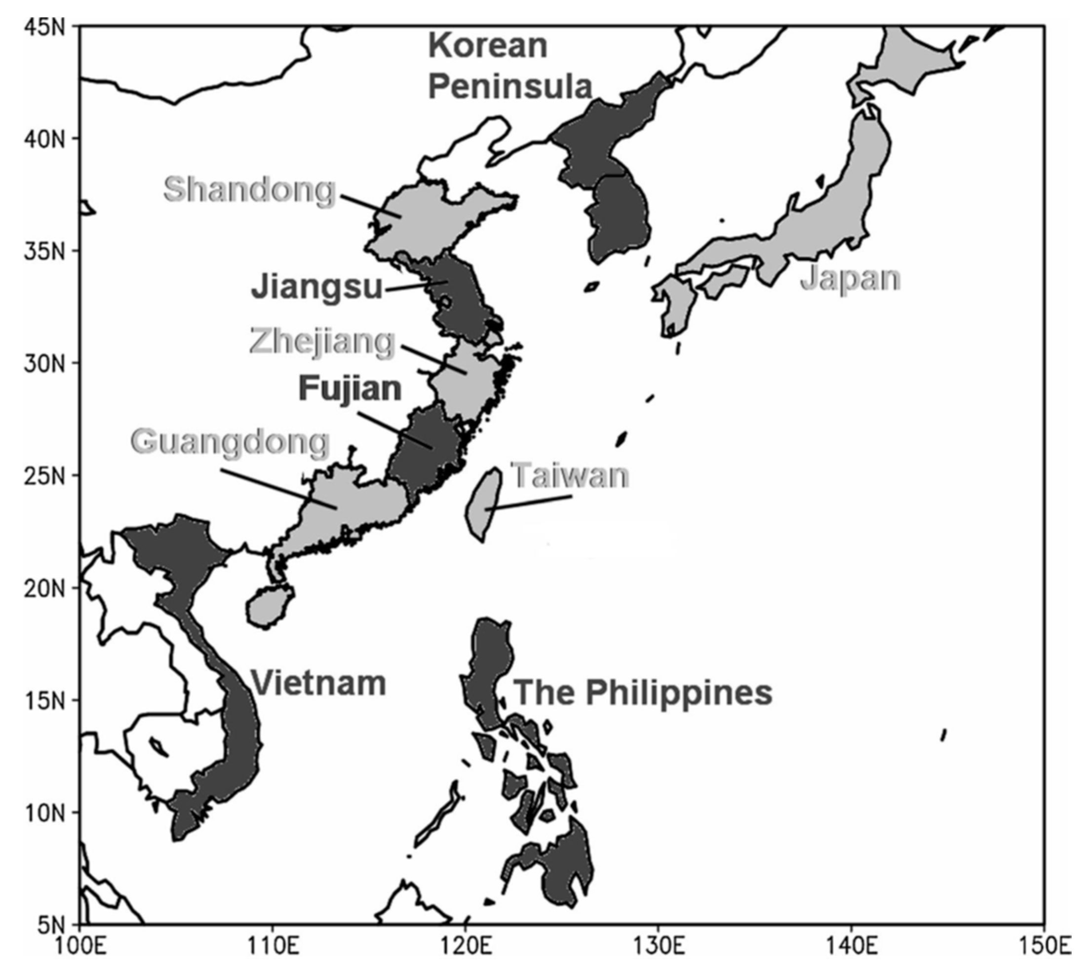
Figure A1.
Provinces in China and other regions discussed in the paper.

References
- Rodionov, S.N. A sequential algorithm for testing climate regime shifts. Geophys. Res. Lett. 2004, 31, L09204. [Google Scholar] [CrossRef] [Green Version]
- Wu, L.; Wang, B.; Geng, S. Growing typhoon influence on east Asia. Geophys. Res. Lett. 2005, 32, L18703. [Google Scholar] [CrossRef] [Green Version]
- Guan, S.; Li, S.; Hou, Y.; Hu, P.; Liu, Z.; Feng, J. Increasing threat of landfalling typhoons in the western North Pacific between 1974 and 2013. Int. J. Appl. Earth Obs. Geoinf. 2018, 68, 279–286. [Google Scholar] [CrossRef]
- Liu, K.S.; Chan, J.C.L. Variations of power dissipation index in the East Asia region. Clim. Dyn. 2017, 48, 1963–1985. [Google Scholar] [CrossRef]
- Liu, K.S.; Chan, J.C.L. Changing relationship between La Niña and tropical cyclone landfalling activity in South China. Int. J. Climatol. 2018, 38, 1270–1284. [Google Scholar] [CrossRef]
- Liu, K.S.; Chan, J.C.L. Interdecadal Variability of Western North Pacific Tropical Cyclone Tracks. J. Clim. 2008, 21, 4464–4476. [Google Scholar] [CrossRef]
- Chan, J.C.L.; Xu, M. Interannual and interdecadal variations of landfalling tropical cyclones in East Asia. Part I: Time series analysis. Int. J. Climatol. 2009, 29, 1285–1293. [Google Scholar] [CrossRef]
- Liu, K.S.; Chan, J.C.L. Interdecadal variation of frequencies of tropical cyclones, intense typhoons and their ratio over the western North Pacific. Int. J. Climatol. 2020, 40, 3954–3970. [Google Scholar] [CrossRef]
- Li, R.C.Y.; Zhou, W.; Shun, C.M.; Lee, T.C. Change in Destructiveness of Landfalling Tropical Cyclones over China in Recent Decades. J. Clim. 2017, 30, 3367–3379. [Google Scholar] [CrossRef]
- Zhang, C.; Hu, C.; Huang, G.; Yao, C.; Zheng, Z.; Wang, T.; Wu, Z.; Yang, S.; Chen, D. Perspective on Landfalling Frequency and Genesis Location Variations of Southern China Typhoon During Peak Summer. Geophys. Res. Lett. 2019, 46, 6830–6838. [Google Scholar] [CrossRef] [Green Version]
- Shan, K.; Yu, X. Variability of Tropical Cyclone Landfalls in China. J. Clim. 2021, 34, 9235–9247. [Google Scholar] [CrossRef]
- Tran-Quang, D.; Pham-Thanh, H.; Vu, T.-A.; Kieu, C.; Phan-Van, T. Climatic Shift of the Tropical Cyclone Activity Affecting Vietnam’s Coastal Region. J. Appl. Meteorol. Climatol. 2020, 59, 1755–1768. [Google Scholar] [CrossRef]
- Kubota, H.; Chan, J.C.L. Interdecadal variability of tropical cyclone landfall in the Philippines from 1902 to 2005. Geophys. Res. Lett. 2009, 36, L12802. [Google Scholar] [CrossRef] [Green Version]
- Cinco, T.A.; de Guzman, R.G.; Ortiz, A.M.D.; Delfino, R.J.P.; Lasco, R.D.; Hilario, F.D.; Juanillo, E.L.; Barba, R.; Ares, E.D. Observed trends and impacts of tropical cyclones in the Philippines. Int. J. Climatol. 2016, 36, 4638–4650. [Google Scholar] [CrossRef] [Green Version]
- Choi, K.-S.; Kim, B.-J.; Kim, D.-W.; Byun, H.-R. Interdecadal variation of tropical cyclone making landfall over the Korean Peninsula. Int. J. Climatol. 2009, 30, 1472–1483. [Google Scholar] [CrossRef]
- Choi, K.-S.; Moon, I.-J. Changes in tropical cyclone activity that has affected Korea since 1999. Nat. Hazards 2012, 62, 971–989. [Google Scholar] [CrossRef]
- Grossman, M.J.; Zaiki, M.; Nagata, R. Interannual and interdecadal variations in typhoon tracks around Japan. Int. J. Climatol. 2014, 35, 2514–2527. [Google Scholar] [CrossRef]
- Yamaguchi, M.; Maeda, S. Increase in the Number of Tropical Cyclones Approaching Tokyo since 1980. J. Meteorol. Soc. Jpn. Ser. II 2020, 98, 775–786. [Google Scholar] [CrossRef]
- Park, D.-S.R.; Ho, C.-H.; Kim, J.-H.; Kim, H.-S. Strong landfall typhoons in Korea and Japan in a recent decade. J. Geophys. Res. Atmos. 2011, 116, D07105. [Google Scholar] [CrossRef] [Green Version]
- Goh, A.Z.-C.; Chan, J.C.L. Variations and prediction of the annual number of tropical cyclones affecting Korea and Japan. Int. J. Climatol. 2010, 32, 178–189. [Google Scholar] [CrossRef]
- Kossin, J.P.; Emanuel, K.A.; Vecchi, G.A. The poleward migration of the location of tropical cyclone maximum intensity. Nature 2014, 509, 349–352. [Google Scholar] [CrossRef] [PubMed] [Green Version]
- Liu, K.S.; Chan, J.C.L.; Kubota, H. Meridional oscillation of tropical cyclone activity in the western North Pacific during the past 110 years. Clim. Chang. 2021, 164. [Google Scholar] [CrossRef]
- Park, D.-S.R.; Ho, C.-H.; Kim, J.-H. Growing threat of intense tropical cyclones to East Asia over the period 1977–2010. Environ. Res. Lett. 2014, 9, 014008. [Google Scholar] [CrossRef] [Green Version]
- Mei, W.; Xie, W.M.S.-P. Intensification of landfalling typhoons over the northwest Pacific since the late 1970s. Nat. Geosci. 2016, 9, 753–757. [Google Scholar] [CrossRef]
- Liu, K.S.; Chan, J.C.L. Inter-decadal variability of the location of maximum intensity of category 4–5 typhoons and its implication on landfall intensity in East Asia. Int. J. Climatol. 2018, 39, 1839–1852. [Google Scholar] [CrossRef]
- Liu, K.S.; Chan, J.C.L. Growing Threat of Rapidly-Intensifying Tropical Cyclones in East Asia. Adv. Atmos. Sci. 2022, 39, 222–234. [Google Scholar] [CrossRef]
- Li, G.; Li, Q.; Xu, Y.; Xu, P.; Wang, W.; Huang, D.; Wu, Y.; He, L. Changes of Tropical Cyclones Landfalling in China from 1979 to 2018. J. Geophys. Res. Atmos. 2022, 127, e2022JD036701. [Google Scholar] [CrossRef]
- Liu, K.S.; Chan, J.C.L. Recent increase in extreme intensity of tropical cyclones making landfall in South China. Clim. Dyn. 2020, 55, 1059–1074. [Google Scholar] [CrossRef]
- Liu, L.; Wang, Y.; Zhan, R.; Xu, J.; Duan, Y. Increasing Destructive Potential of Landfalling Tropical Cyclones over China. J. Clim. 2020, 33, 3731–3743. [Google Scholar] [CrossRef]
- Chan, J.C.L. Tropical cyclone activity in the northwest Pacific in relation to the El Niño/Southern Oscillation phenomenon. Mon. Weather Rev. 1985, 113, 599–606. [Google Scholar] [CrossRef]
- Chan, J.C.L. Tropical cyclone activity over the western North Pacific associated with El Niño and La Niña events. J. Clim. 2000, 13, 2960–2972. [Google Scholar] [CrossRef]
- Wang, B.; Chan, J.C.L. How Strong ENSO Events Affect Tropical Storm Activity over the Western North Pacific. J. Clim. 2002, 15, 1643–1658. [Google Scholar] [CrossRef]
- Lin, I.I.; Camargo, S.; Patricola, C.; Boucharel, J.; Chand, S.; Klotzbach, P.; Chan, J.; Wang, B.; Chang, P.; Li, T.; et al. ENSO and Tropical Cyclones. In El Niño Southern Oscillation in a Changing Climate, Geophysical Monograph 253, 1st ed.; McPhaden, M.J., Santoso, A., Cai, W., Eds.; American Geophysical Union: Washington, DC, USA, 2021. [Google Scholar]
- Zhou, X.; Lu, R. Interannual Variability of the Tropical Cyclone Landfall Frequency over the Southern and Northern Regions of East Asia in Autumn. J. Clim. 2019, 32, 8677–8686. [Google Scholar] [CrossRef]
- Zhang, W.; Graf, H.-F.; Leung, Y.; Herzog, M. Different El Niño Types and Tropical Cyclone Landfall in East Asia. J. Clim. 2012, 25, 6510–6523. [Google Scholar] [CrossRef]
- Wu, M.C.; Chang, W.; Leung, W.M. Impacts of El Niño-Southern Oscillation events on tropical cyclone landfalling activity in the western North Pacific. J. Clim. 2004, 17, 1419–1428. [Google Scholar] [CrossRef]
- Ho, C.-H.; Kim, H.-S. Reexamination of the influence of ENSO on landfalling tropical cyclones in Korea. Asia-Pac. J. Atmos. Sci. 2011, 47, 457–462. [Google Scholar] [CrossRef]
- Zhang, H.; Guan, Y. Impacts of four types of ENSO events on tropical cyclones making landfall over mainland china based on three best-track datasets. Adv. Atmos. Sci. 2013, 31, 154–164. [Google Scholar] [CrossRef]
- Yonekura, E.; Hall, T.M. ENSO Effect on East Asian Tropical Cyclone Landfall via Changes in Tracks and Genesis in a Statistical Model. J. Appl. Meteorol. Climatol. 2014, 53, 406–420. [Google Scholar] [CrossRef] [Green Version]
- Gao, S.; Chen, Z.; Zhang, W. Impacts of Tropical North Atlantic SST on Western North Pacific Landfalling Tropical Cyclones. J. Clim. 2018, 31, 853–862. [Google Scholar] [CrossRef]
- Gao, S.; Chen, Z.; Zhang, W.; Shen, X. Effects of tropical North Atlantic sea surface temperature on intense tropical cyclones landfalling in China. Int. J. Climatol. 2020, 41, 1056–1065. [Google Scholar] [CrossRef]
- Wang, L.; Chen, G. Impact of the Spring SST Gradient between the Tropical Indian Ocean and Western Pacific on Landfalling Tropical Cyclone Frequency in China. Adv. Atmos. Sci. 2018, 35, 682–688. [Google Scholar] [CrossRef]
- Wang, L.; Chen, G. Relationship between South China Sea summer monsoon onset and landfalling tropical cyclone frequency in China. Int. J. Climatol. 2018, 38, 3209–3214. [Google Scholar] [CrossRef]
- Choi, K.-S.; Park, S.; Chang, K.-H.; Lee, J.-H. A possible relationship between East Indian Ocean SST and tropical cyclone affecting Korea. Nat. Hazards 2014, 76, 283–301. [Google Scholar] [CrossRef]
- Mantua, N.J.; Hare, S.R.; Zhang, Y.; Wallace, J.; Francis, R.C. A Pacific interdecadal climate oscillation with impacts on salmon production. Bull. Am. Meteor. Soc. 1997, 78, 1069–1079. [Google Scholar] [CrossRef]
- Yang, L.; Chen, S.; Wang, C.; Wang, D.; Wang, X. Potential impact of the Pacific Decadal Oscillation and sea surface temperature in the tropical Indian Ocean–Western Pacific on the variability of typhoon landfall on the China coast. Clim. Dyn. 2017, 51, 2695–2705. [Google Scholar] [CrossRef] [Green Version]
- Choi, J.-W.; Cha, Y.; Lu, R. Possible Relationship between Korea Affecting Tropical Cyclone Activity and Pacific Decadal Oscillation in Summer. Asia-Pac. J. Atmos. Sci. 2019, 55, 557–573. [Google Scholar] [CrossRef]
- Choi, J.-W.; Kim, H.-D. Negative relationship between Korea landfalling tropical cyclone activity and Pacific Decadal Oscillation. Dyn. Atmos. Oceans 2019, 87, 101100. [Google Scholar] [CrossRef]
- Choi, J.; Kim, H. Possible combined effect of El Niño–Southern Oscillation and Pacific Decadal Oscillation on Korea affecting tropical cyclone passage frequency. Atmos. Sci. Lett. 2019, 21, e907. [Google Scholar] [CrossRef] [Green Version]
- Wang, X.; Wang, C.; Zhang, L.; Wang, X. Multidecadal Variability of Tropical Cyclone Rapid Intensification in the Western North Pacific. J. Clim. 2015, 28, 3806–3820. [Google Scholar] [CrossRef]
- Gao, S.; Zhu, L.; Zhang, W.; Shen, X. Impact of the Pacific Meridional Mode on landfalling tropical cyclone frequency in China. Quart. J. Roy. Meteorol. Soc. 2020, 146, 2410–2420. [Google Scholar] [CrossRef]
- Chiang, J.C.H.; Vimont, D.J. Analogous Pacific and Atlantic Meridional Modes of Tropical Atmosphere–Ocean Variability. J. Clim. 2004, 17, 4143–4158. [Google Scholar] [CrossRef]
- Henley, B.J.; Gergis, J.; Karoly, D.J.; Power, S.; Kennedy, J.; Folland, C.K. A Tripole Index for the Interdecadal Pacific Oscillation. Clim. Dyn. 2015, 45, 3077–3090. [Google Scholar] [CrossRef]
- Knutson, T.; Camargo, S.J.; Chan, J.C.L.; Emanuel, K.; Ho, C.-H.; Kossin, J.; Mohapatra, M.; Satoh, M.; Sugi, M.; Walsh, K.; et al. Tropical Cyclones and Climate Change Assessment: Part I: Detection and Attribution. Bull. Am. Meteorol. Soc. 2019, 100, 1987–2007. [Google Scholar] [CrossRef] [Green Version]
- Knutson, T.; Camargo, S.J.; Chan, J.C.L.; Emanuel, K.; Ho, C.-H.; Kossin, J.; Mohapatra, M.; Satoh, M.; Sugi, M.; Walsh, K.; et al. Tropical Cyclones and Climate Change Assessment: Part II: Projected Response to Anthropogenic Warming. Bull. Am. Meteorol. Soc. 2020, 101, E303–E322. [Google Scholar] [CrossRef]
- Eyring, V.; Bony, S.; Meehl, G.A.; Senior, C.A.; Stevens, B.; Stouffer, R.J.; Taylor, K.E. Overview of the Coupled Model Intercomparison Project Phase 6 (CMIP6) experimental design and organization. Geosci. Model Dev. 2016, 9, 1937–1958. [Google Scholar] [CrossRef] [Green Version]
- Tsuboki, K.; Yoshioka, M.K.; Shinoda, T.; Kato, M.; Kanada, S.; Kitoh, A. Future increase of supertyphoon intensity associated with climate change. Geophys. Res. Lett. 2015, 42, 646–652. [Google Scholar] [CrossRef]
- Mizuta, R.; Oouchi, K.; Yoshimura, H.; Noda, A.; Katayama, K.; Yukimoto, S.; Hosaka, M.; Kusunoki, S.; Kawai, H.; Nakagawa, M. 20-km-mesh global climate simulations using JMA-GSM model—Mean climate states. J. Meteor. Soc. Jpn. 2006, 84, 165–185. [Google Scholar] [CrossRef] [Green Version]
- Wang, C.; Liang, J.; Hodges, K.I. Projections of tropical cyclones affecting Vietnam under climate change: Downscaled HadGEM2-ES using PRECIS 2.1. Quart. J. Roy. Meteorol. Soc. 2017, 143, 1844–1859. [Google Scholar] [CrossRef]
- Gallo, F.; Daron, J.; Macadam, I.; Cinco, T.; Villafuerte, M.; Buonomo, E.; Tucker, S.; Hein-Griggs, D.; Jones, R.G. High-resolution regional climate model projections of future tropical cyclone activity in the Philippines. Int. J. Climatol. 2018, 39, 1181–1194. [Google Scholar] [CrossRef] [Green Version]
- Lok, C.C.F.; Chan, J.C.L. Changes of tropical cyclone landfalls in Southern China throughout the twenty-first century. Clim. Dyn. 2018, 51, 2467–2483. [Google Scholar] [CrossRef]
- Lok, C.C.F.; Chan, J.C.L. Simulating seasonal tropical cyclone intensities at landfall along South China coast. Clim. Dyn. 2018, 50, 2661–2672. [Google Scholar] [CrossRef]
- Kanada, S.; Tsuboki, K.; Takayabu, I. Future changes of tropical cyclones in the midlatitudes in 4-km mesh downscaling experiments from large-ensemble simulations. SOLA 2020, 16, 57–63. [Google Scholar] [CrossRef] [Green Version]
- Mizuta, R.; Murata, A.; Ishii, M.; Shiogama, H.; Hibino, K.; Mori, N.; Arakawa, O.; Imada, Y.; Yoshida, K.; Aoyagi, T.; et al. Over 5,000 Years of Ensemble Future Climate Simulations by 60-km Global and 20-km Regional Atmospheric Models. Bull. Am. Meteorol. Soc. 2017, 98, 1383–1398. [Google Scholar] [CrossRef]
- Wu, J.; Gao, X.; Zhu, Y.; Shi, Y.; Giorgi, F. Projection of the Future Changes in Tropical Cyclone Activity Affecting East Asia over the Western North Pacific Based on Multi-RegCM4 Simulations. Adv. Atmos. Sci. 2021, 39, 284–303. [Google Scholar] [CrossRef]
- Hsu, P.; Chen, K.; Tsou, C.; Hsu, H.; Hong, C.; Liang, H.; Tu, C.; Kitoh, A. Future Changes in the Frequency and Destructiveness of Landfalling Tropical Cyclones Over East Asia Projected by High-Resolution AGCMs. Earth’s Future 2021, 9, e2020EF001888. [Google Scholar] [CrossRef]
Figure 1.
(a) June–October average annual frequency of TC occurrence (number per year) in the WNP from 1965 to 2003 (from Wu et al. [2]). I, II and III represent the three major tracks and A shows the location of maximum frequency of occurrence. (b) Lifetime maximum intensity (LMI) and landfall intensity (LFI) probability distribution functions for each category of landfalling TCs (only those TCs with LMI reaching Category 1 intensity or above are included). (c) Latitudinal variation of mean LFI (solid, shading indicates the standard deviation per squared sample number) and maximum LFI during the study period (dashed). (b,c) are extracted from Guan et al. [3].

Figure 2.
Annual (a) total number and (b) percentage (relative to all TCs in the WNP) of TCs making landfall along the EA coast during 1975–2020. The green lines indicate possible change points of the time series as identified using the Rodinov [1] approach. The black line is the linear trend.
Figure 2.
Annual (a) total number and (b) percentage (relative to all TCs in the WNP) of TCs making landfall along the EA coast during 1975–2020. The green lines indicate possible change points of the time series as identified using the Rodinov [1] approach. The black line is the linear trend.

Figure 3.
Loading patterns of the annual TC occurrence pattern for (a) the first, (b) second, and (c) third EOFs. The prevailing tracks are labeled as A, B, C, and D. For positive values of the PC coefficients, solid arrows indicate increased frequency and dashed arrows indicate negative frequency. (d–f) are the time series of PC1, PC2, and PC3 coefficients, respectively. The vertical lines indicate the four subperiods defined in Liu and Chan [6] (from Liu and Chan [6]).

Figure 4.
Number of landfalling TCs (maximum wind speed at landfall ≥ 34 kt) in each of the regions along the EA coast during 1945–2020. (a) South China, (c) Fujian, (e) Taiwan, (g) Zhejiang, (b) Vietnam, (d) Philippines, (f) Korean Peninsula, and (h) Japan. Black line indicates a linear trend, with the statistical significance indicated on top of the figure. Those marked “x” indicates that the trend is not statistically significant. Green line indicates result from a change-point analysis (Rodinov [1]) with a 10-year threshold and a statistically significant change at 95% confidence level.

Figure 5.
“Time-region” south–north cross-section of the standardized APDI anomalies (105 knot3) for different regions along the EA coast, from Vietnam, Guangdong, Taiwan, Zhejiang, the Korean Peninsula to Japan. Dark (light) shadings indicate the anomalies of APDI > 0.5σ (<−0.5σ), σ being the standard deviation. Vertical dashed lines represent the times of occurrence of the significant changes in the APDI distribution (from Liu and Chan [4], permission obtained).

Figure 6.
As in Figure 4 except for APDI (105 knot3).
Figure 6.
As in Figure 4 except for APDI (105 knot3).


Table 1.
Annual average number and APDI (105 knot3) of TCs making landfall in various regions along the EA coast.
Table 1.
Annual average number and APDI (105 knot3) of TCs making landfall in various regions along the EA coast.
| Region | Number (Rounded off to Integer) | APDI |
|---|---|---|
| Japan | 3 | 113.2 |
| Korean Peninsula | 1 | 18.5 |
| Zhejiang Province | 1 | 29.3 |
| Fujian Province | 2 | 42.9 |
| Taiwan Island | 2 | 107.0 |
| South China (Guangdong, Guangxi and Hainan provinces) | 5 | 114.7 |
| Philippines | 6 | 307.7 |
| Vietnam | 3 | 68.4 |
Table 2.
Summaries of the trend of the frequency of landfalling TCs, possible observed interannual and interdecadal variations, as well as their relationships with various atmospheric and oceanic oscillations in different EA coastal regions.
Table 2.
Summaries of the trend of the frequency of landfalling TCs, possible observed interannual and interdecadal variations, as well as their relationships with various atmospheric and oceanic oscillations in different EA coastal regions.
| Region | Interannual Variation | Interdecadal Variation | Trend |
|---|---|---|---|
| South China |
|
|
|
| East China |
|
|
|
| Vietnam |
|
| |
| Philippines |
|
|
|
| Korean Peninsula |
|
|
|
| Japan |
|
|
|
Table 3.
As in Table 2 except for the intensity of the TCs at landfall.
Table 3.
As in Table 2 except for the intensity of the TCs at landfall.
| Region | Interdecadal Variation | Trend |
|---|---|---|
| South China |
| |
| East China |
|
|
| Vietnam |
| |
| Philippines |
| |
| Korean Peninsula |
| |
| Japan |
|
Disclaimer/Publisher’s Note: The statements, opinions and data contained in all publications are solely those of the individual author(s) and contributor(s) and not of MDPI and/or the editor(s). MDPI and/or the editor(s) disclaim responsibility for any injury to people or property resulting from any ideas, methods, instructions or products referred to in the content. |
© 2023 by the author. Licensee MDPI, Basel, Switzerland. This article is an open access article distributed under the terms and conditions of the Creative Commons Attribution (CC BY) license (https://creativecommons.org/licenses/by/4.0/).
Share and Cite
MDPI and ACS Style
Chan, J.C.L. Frequency and Intensity of Landfalling Tropical Cyclones in East Asia: Past Variations and Future Projections. Meteorology 2023, 2, 171-190. https://doi.org/10.3390/meteorology2020012
AMA Style
Chan JCL. Frequency and Intensity of Landfalling Tropical Cyclones in East Asia: Past Variations and Future Projections. Meteorology. 2023; 2(2):171-190. https://doi.org/10.3390/meteorology2020012
Chicago/Turabian StyleChan, Johnny C. L. 2023. "Frequency and Intensity of Landfalling Tropical Cyclones in East Asia: Past Variations and Future Projections" Meteorology 2, no. 2: 171-190. https://doi.org/10.3390/meteorology2020012