Proceeding Paper

Stacking Lake Ice Analog Cryotectonic Dynamics on Dione’s Wispy Terrain †

1
Faculty of Oceanology, Kobe University, 5-1-1 Fukaeminami-machi, Higashinada-ku, Kobe 658-0022, Japan
2
Faculty of Geography, Universitas Gadjah Mada, Yogyakarta 55281, Indonesia
*
Author to whom correspondence should be addressed.
Presented at the 2nd Electronic Conference on Universe, 16 February–2 March 2023; Available online: https://ecu2023.sciforum.net/.
Phys. Sci. Forum 2023, 7(1), 18; https://doi.org/10.3390/ECU2023-14030
Published: 15 February 2023
(This article belongs to the Proceedings of The 2nd Electronic Conference on Universe)

Abstract

:
Wispy Terrain, with its chasmata, is one of the enigmatic regions of Dione. It consists of quasi-parallel graben, and troughs, in parts with horsts, indicating extensional and shear stresses. This study introduces some observations of compression-related features and proposes a new regional formation model. The study of the relationship between impact craters and tectonic features revealed certain “lost” parts of some crosscut craters, indicating additional cryotectonic features, the appearance of accretionary prism-like phenomena, and, theoretically, subsumption-like processes. This study provides new information about the surface renewal processes at one of the youngest and probably still active regions of Dione.

1. Introduction

Saturn’s icy moon Dione and its enigmatic feature, the so-called Wispy Terrain, have been the object of scientific debate for a long time. It was named Wispy Terrain following the analysis of Voyager images, referring to the frequent appearance of wispy streaks, markings, or lines. The early astrogeological mapping of Dione provides a detailed first view (as much it was possible based on the Voyager images) of the geological features of the Wispy Terrain as well, but, beyond a chronostratigraphic proposal, no clear age determination could be made about its formation time [1,2].
Compared to the densely cratered terrains, possibly the oldest surface on the satellite (~3–4.2 Ga), results from the Eurotas Chasmata (Figure 1) indicate that the cryotectonic processes in the region might be active until ~3Ga, or even until ~1 Ga ago [3,4]. Almost three decades after the first geological mapping [1,2], the main terrains were re-evaluated in light of the new data [5]. The markings of the Wispy Terrain are defined as a set of quasi-parallel troughs, scarps, and “horst and graben” systems, indicating extensional and shear stress in the region. Please note that since the early studies, mentioned compressional stress-related landforms [2], most of the studies emphasize extension and shear stress in the ice-crust of the satellite. The chasmata systems (e.g., the Eurotas and Palatine Chasmata) are defined as Fractured Cratered Plains and subdivided into three facies types, based on the timing of their formation, which date back to 3.7 Ga (with 100 Ma uncertainties) or alternatively happened between 2.7 Ga and 260 Ma [5].
Following the re-definition of the terrains on Dione, the newly computed ages (4.3 [+0.2/−2.7] Ga—⌀ > 45 km crater age, and 2.5 [+2.0/−1.9] Ga—⌀ ≤ 45 km crater age) for the Faulted Terrain (also known as the Wispy Terrain) showed that these ages do not reflect the timing of cryotectonic activity (i.e., faulting), but the time span over which the larger craters and their ejecta blankets erased the smaller craters in the region [6].
Based on the analog geological characteristics between the fault system of chasmata and Earth’s regions with the extension-drive divergent tectonic plates, Dione`s Faulted Terrain was defined as hemisphere-scale rift zones [7,8].
The possibility of a subsurface ocean under the ice shell [9], similar to Dione`s active neighbor, Enceladus [10], brought the promise of a still active surface and a potential for life harbored under the icy shell. The study of the stratigraphic relationship between the craters and faults on the Wispy Terrain suggests that the faulting is a geologically very recent event, dating back to 0.3–0.79 Ga [11]. Some of the newest studies go even further and suggest that the upper limit for the age of studied fault on Wispy Terrain is only 152 Ma, which supports the hypothesis that the cryotectonism might still be active or was active a very short time ago (c.a. 100 Ma) on the satellite [12].
In certain situations, mere coincidence would lead to discovery (or false belief, at the same time) [13]. In the case of this study, such a coincidence has three components: (i) the mapping of impact craters, as a part of another ongoing research, (ii) the observation of fragmentary craters, and (iii) a viral video of stacking lake ice, seen during a short break. These three “circumstances” lead to a theory and discovery about the potential of subsumption (a subduction-like) mechanism [14] on Dione. Here, we provide some evidence that supports the existence of compressional stress field and subsumption during the evolution of the Wispy Terrain and its chasmata.

2. Data and Methods

The studied region, the Wispy Terrains, is spreading approximately between latitude 40° and −60° and longitude 260° to 350° (westward) (Figure 1). The focus of this research is between Palatine and the “southern” section of Eurotas Chasmata. The map is based on Cassini—Voyager Global Mosaic 154m v1 map, which can be found at the internet site Astropedia—Lunar and Planetary Cartographic Catalog [15,16,17,18]. The applied nomenclature follows the recommendation of the Gazetteer of Planetary Nomenclature [19].
The GIS research and the mapping of craters and other geological features were performed by QGIS 3.22 software. In previous studies, the mapping of craters in Dione was limited to craters with ⌀ ≥ 4 km crater diameter due to problems during the identification of smaller craters in image mosaics with lower resolution [6]. The crater mapping also had some limitations in certain areas due to the distortion of the map.

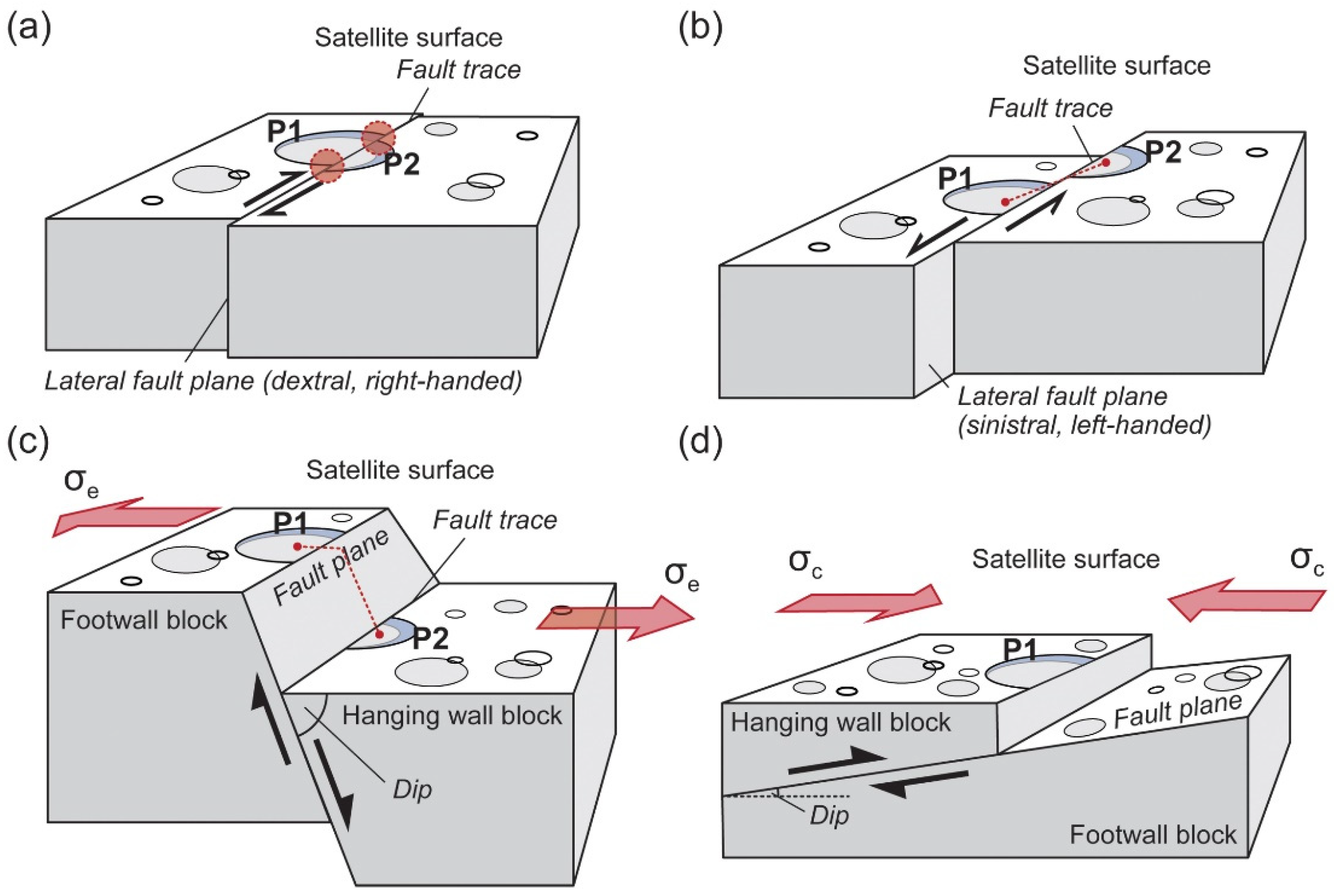
Crater Preservation in Various Cryotectonic Settings—Theory behind the Research

In some cases of short-distance horizontal allocation of the crater fragments (strike-slip faults), the cryotectonic activity “only” causes the distortion of the crater rim, resulting in visible sharp edges in the supposedly curved-shaped rim. The whole crater is still recognizable (Figure 2a). In certain cases of horizontal allocation (strike-slip faults), the parts of the crater may move further distance, but even in such cases, the component parts are recognizable along the fault trace, and the crater is re-constructible (Figure 2b).
Normal (and in some case reverse) faulting may cause the allocation of the crater fragments along a fault plane with a certain dip to the horizontal plane. Based on the angle of the dip (deep to shallow) and the orientation of the fault planes of individual blocks in a fault system, various fault types may form on the crust of icy satellites, such as normal faults, horst, and graben structures, domino-style fault blocks, and listric normal faults [20]. Among many similarities, there is one that is important regarding the preservation of the crater fragments, separated by deep or shallow angle normal faulting: despite the allocation of the crater parts, they are recognizable on the original surface of the footwall and hanging wall block as well, and the “whole” crater is re-constructible (Figure 2c).
The commonality in the suggested processes above is that in every case, the parts of the crater are recognizable, and the crater itself is re-constructible. One of the exceptional cases would be the formation of thrust faults, a reverse fault with a shallow dip, with a hanging wall that moves up and over the footwall. In such cases, the hanging wall may “cover” a certain part of the footwall top, resulting in fragmentary or incomplete craters (“half-craters”) without any recognizable and completing other connecting crater parts in their surroundings (Figure 2d).
The key (and simplified) difference between the various faults is that various types of normal faults are formed in extensional- and thrust faults (low-angle reverse faults) in a compressional stress field. Strike-slip faults are caused by horizontal compression, but compared to thrust faults, their displacement is quasi-parallel to the compressional force (shear stress). In this study, the focus is on the fragmentary craters, which may indicate thrust fault cryotectonic settings, formed in a compressional stress field (Figure 2d).

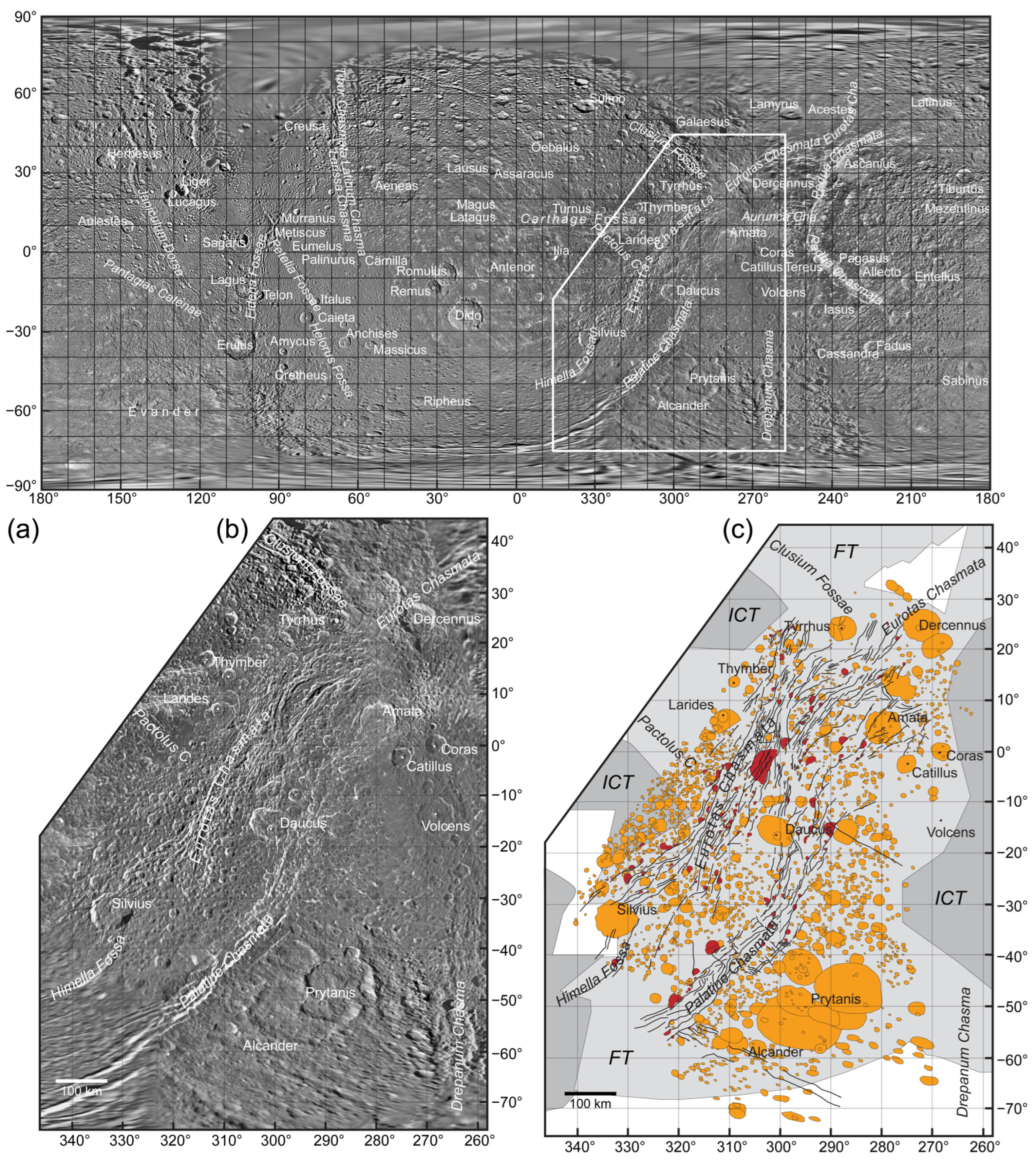
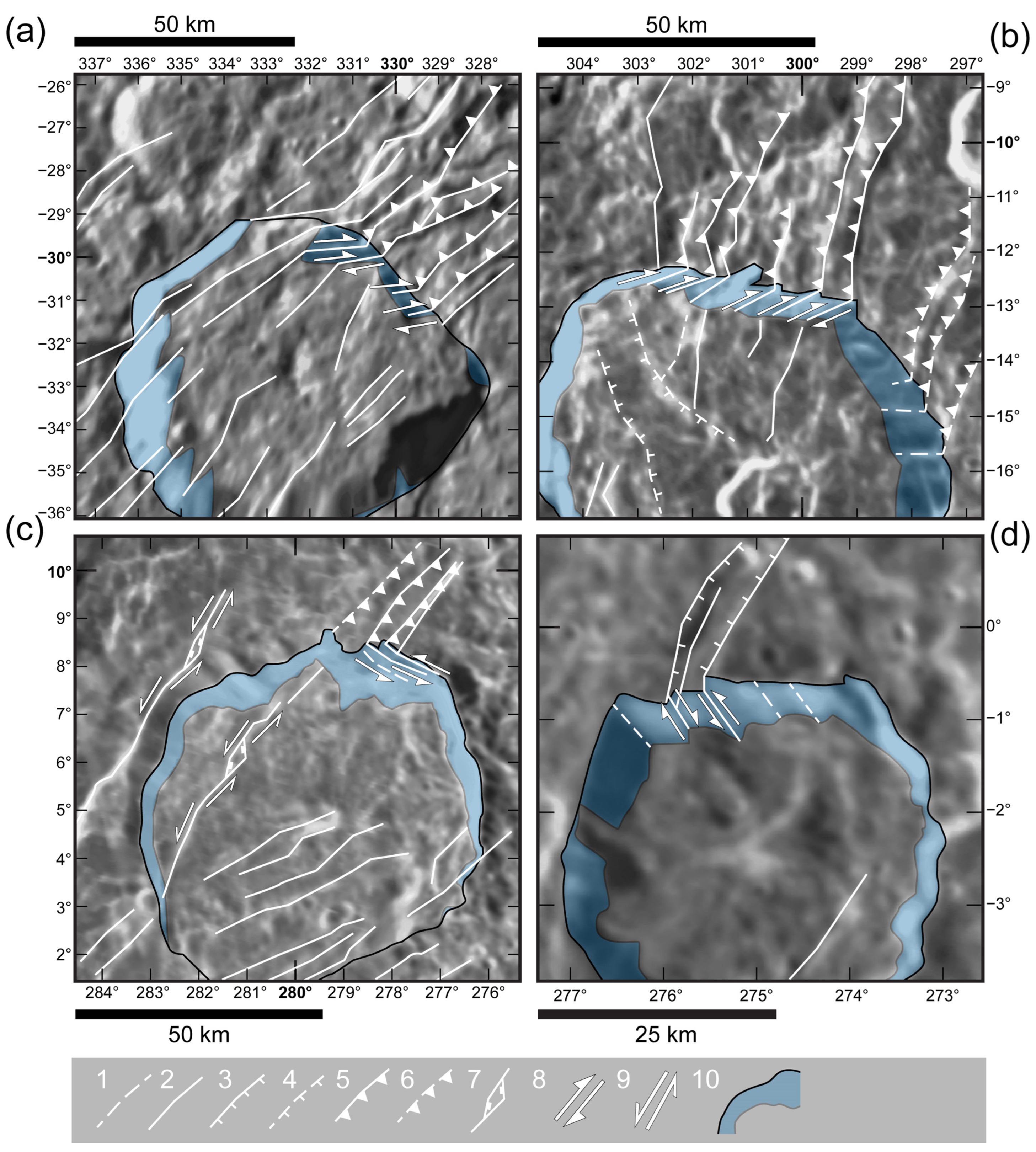
3. Results and Discussion—Putative Thrust Faults of the Wispy Terrain

The preliminary geological mapping of the area resulted in the identification of close to 450 main tectonic lines and 2500 craters, including the ones with missing, “untraceable” parts (Figure 1c). Despite the preliminary nature of the map, the relationship between the tectonically active zones and the increasing number of fragmentary craters along the tectonic lines seems clear, which may indicate thrust faulting (Figure 2d) as one of the key cryotectonic processes in the region. Compared to the previous studies [7,8,20], thrust faults indicate a compressional stress field and convergence of plates. In a terrestrial environment, thrust fault may develop when two blocks collide, and it may lead to the formation of so-called splay and décollement faults, one of the most characteristic components of subduction zones (e.g., found in the accretionary wedges) [21].
To verify the results of the crater mapping, the walls of larger craters found in a region and crosscut by tectonic lines were investigated. Despite the potential bias due to the resolution of the images, certain structural geological characteristics might be recognizable (Figure 3). Without any knowledge about the appearance of fragmentary craters in the surroundings, putative faults, observed in Figure 3a,b, might be identified as domino-style normal faults [20,22] or thrust faults, but supported by various pieces of evidence, the possibility of the former ones was already excluded [20]. As an alternative to thrust faults, the features in Figure 3c may be recognized as listric normal faults. Unfortunately, in this resolution, it is hard to recognize key features such as the thrust sheets (the “imbricating splays” of the splay and décollement faults) or the tilted face of the blocks (a listric normal fault), which may help to decide between the two features. As a comparison of the putative thrust faults, the features in Figure 3d most likely indicate a normal fault system of a “graben” structure between two uplifted blocks. Despite the uncertainty about the faults in Figure 3a–c, they may be identified as thrust/splay and décollement faults.

4. Conclusions—Subsumption or Chaotic Ice Stacking… or Both?

Extensional stress fields seem common on Dione`s crust, resulting in the development of various types of normal fault systems [20]. The scale of the dilatational features spans from step faults, horst and graben structures to hemisphere-scale rift zones [7,8]. The discovery of potential thrust/splay and décollement faults may make the surface renewal models more complex than thought before. The appearance of compression-related tectonic features, especially the ones whose morphology is reminiscent of the structure of an accretionary prism in a terrestrial environment, may suggest the existence of subsumption (subduction-like) processes on Dione (Figure 4). Ideally, it means that Wilson cycle-like tectonic cycles may appear in icy planetary bodies [23], and Dione`s Wispy Terrain, which consists of divergent and convergent sections as well, may turn out to be the model region for it. Rifting may be triggered by endogenic (e.g., phase change within the satellite, solid-state convection in the crust, and thermal plumes) and exogenic (e.g., diurnal tides, tidal forces, orbital forcing, and non-synchronous rotation of the ice shell) processes [7,8,24,25]. This section of the ice crust may spread due to the continuous material accretion via cryovolcanic activity [12] and at a certain geological moment it may collide with thicker, more stable, and possibly older terrain of the crust (Figure 1c); e.g., some evolving part of the Faulted Terrain collides the much older Intermediate Cratered Terrain [6].
Only one question remains, would such collision develop Earth analog subduction connected features (e.g., the identified thrust faults; Figure 4), or would result in a more chaotic cryotetconic setting, similar to the stacking lake ice, observed at Lake Superior [26,27]? The next goal of our research is to map various crater-fault relations and reconstruct the stress field that appears in the wispy Terrain, especially in the region of the Palatine and Eurotas Chasmata, and may be able to answer such questions.

Author Contributions

Conceptualization, B.B.; methodology, B.B., C.G.; investigation, B.B.; writing—original draft preparation, B.B.; writing—review and editing, B.B., R.N.; and visualization, B.B. All authors have read and agreed to the published version of the manuscript.

Funding

This research received no external funding.

Institutional Review Board Statement

Not applicable.

Informed Consent Statement

Not applicable.

Data Availability Statement

Data will be available upon request.

Conflicts of Interest

The authors declare no conflict of interest.

References

  1. Plescia, J.B. The geology of Dione. Icarus 1983, 56, 255–277. [Google Scholar] [CrossRef]
  2. Moore, J.M. The tectonic and volcanic history of Dione. Icarus 1984, 59, 205–220. [Google Scholar] [CrossRef]
  3. Zahnle, K.; Schenk, P.; Levison, H.; Dones, L. Cratering rates in the outer Solar System. Icarus 2003, 163, 263–289. [Google Scholar] [CrossRef] [Green Version]
  4. Wagner, R.J.; Neukum, G.; Stephan, K.; Roatsch, T.; Wolf, U.; Porco, C.C. Stratigraphy of tectonic features on Saturn’s satellite Dione derived from Cassini ISS camera data. In Proceedings of the 40th Lunar and Planetary Science Conference, The Woodlands, TX, USA, 23–27 March 2009; Available online: https://www.lpi.usra.edu/meetings/lpsc2009/pdf/2142.pdf (accessed on 14 February 2023).
  5. Stephan, K.; Jaumann, R.; Wagner, R.; Clark, R.N.; Cruikshank, D.P.; Hibbitts, C.A.; Roatsch, T.; Hoffmann, H.; Brown, R.H.; Filiacchione, G.; et al. Dione’s spectral and geological properties. Icarus 2010, 206, 631–652. [Google Scholar] [CrossRef] [Green Version]
  6. Kirchoff, M.R.; Schenk, P. Dione’s resurfacing history as determined from a global impact crater database. Icarus 2015, 256, 78–89. [Google Scholar] [CrossRef]
  7. Byrne, P.K.; Schenk, P.M.; McGovern, P.J. Tectonic mapping of rift zones on Rhea, Tethys and Dione. In Proceedings of the 46th Lunar and Planetary Science Conference, The Woodlands, TX, USA, 16–20 March 2015; Available online: https://www.hou.usra.edu/meetings/lpsc2015/pdf/2251.pdf (accessed on 14 February 2023).
  8. Byrne, P.K.; Schenk, P.; McGovern, P.; Collins, G. Hemispheric-scale rift zones on Rhea, Tethys, and Dione. In Proceedings of the Enceladus and the Icy Moons of Saturn Conference, Boulder, CO, USA, 26–29 July 2016; Available online: https://www.hou.usra.edu/meetings/enceladus2016/pdf/3020.pdf (accessed on 14 February 2023).
  9. Beuthe, M.; Rivoldini, A.; Trinh, A. Enceladus’ and Dione’s floating ice shells supported by minimum stress isostasy. Geophys. Res. Lett. 2016, 43, 10–088. [Google Scholar] [CrossRef] [Green Version]
  10. Porco, C.C.; Helfenstein, P.; Thomas, P.C.; Ingersoll, A.P.; Wisdom, J.; West, R.; Neukum, G.; Denk, T.; Wagner, R.; Roatsch, T.; et al. Cassini observes the active South Pole of Enceladus. Science 2006, 311, 1393–1401. [Google Scholar] [CrossRef] [PubMed] [Green Version]
  11. Hirata, N. Timing of the faulting on the Wispy Terrain of Dione based on stratigraphic relationships with impact craters. J. Geophys. Res. Planets 2016, 121, 2325–2334. [Google Scholar] [CrossRef] [Green Version]
  12. Ore, C.M.D.; Long, C.J.; Nichols-Fleming, F.; Scipioni, F.; Valentín, E.G.R.; Oquendo, A.J.L.; Cruikshank, D.P. Dione’s Wispy Terrain: A cryovolcanic story? Planet. Sci. J. 2021, 2, 10. [Google Scholar] [CrossRef]
  13. Griffiths, T.L.; Tenenbaum, J.B. From mere coincidences to meaningful discoveries. Cognition 2007, 103, 180–226. [Google Scholar] [CrossRef] [PubMed]
  14. Kattenhorn, S.; Prockter, L. Evidence for subduction in the ice shell of Europa. Nat. Geosci. 2014, 7, 762–767. [Google Scholar] [CrossRef]
  15. Batson, R. Voyager 1 and 2 Atlas of Six Saturnian Satellites (NASA-SP-474); National Aeronautics and Space Administration (NASA): Washington, DC, USA, 1984. Available online: https://ntrs.nasa.gov/archive/nasa/casi.ntrs.nasa.gov/19840027171.pdf (accessed on 14 February 2023).
  16. Greely, R.; Batson, R. Planetary Mapping; Cambridge University Press: New York, NY, USA, 2007; p. 312. ISBN 0-521-30774-0. [Google Scholar]
  17. Roatsch, T.; Kersten, E.; Matz, K.D.; Scholten, F.; Wagner, R.; Porco, C. Cartography of the medium-sized Saturnian satellites based on Cassini-ISS images. In Proceedings of the Enceladus and the Icy Moons of Saturn Conference, Lunar and Planetary Institute, Boulder, CO, USA, 26–29 July 2016; Available online: https://www.hou.usra.edu/meetings/enceladus2016/pdf/3032.pdf (accessed on 14 February 2023).
  18. Schneck, P. Global color and cartographic mapping of Saturn’s midsize icy moons. In Proceedings of the Enceladus and the Icy Moons of Saturn Conference, Lunar and Planetary Institute, Boulder, CO, USA, 26–29 July 2016; Available online: https://www.hou.usra.edu/meetings/enceladus2016/pdf/3053.pdf (accessed on 14 February 2023).
  19. Gazetteer of Planetary Nomenclature. International Astronomical Union (IAU), Working Group for Planetary System No-menclature (WGPSN). Available online: https://asc-planetarynames-data.s3.us-west-2.amazonaws.com/dione_comp.pdf (accessed on 11 December 2022).
  20. Beddingfield, C.B.; Burr, D.M.; Dunne, W.M. Shallow normal fault slopes on Saturnian icy satellites. J. Geophys. Res. Planets 2015, 120, 2053–2083. [Google Scholar] [CrossRef]
  21. Moore, G.F.; Bangs, N.L.; Taira, A.; Kuramoto, S.; Pangborn, E.; Tobin, H.J. Three-dimensional splay fault geometry and implications for tsunami generation. Science 2007, 318, 1128–1131. [Google Scholar] [CrossRef] [PubMed] [Green Version]
  22. Pappalardo, R.T.; Collins, G.C. Strained craters on Ganymede. J. Struct. Geol. 2005, 27, 827–838. [Google Scholar] [CrossRef]
  23. Wilson, R.W.; Houseman, G.A.; Buiter, S.J.H.; McCaffrey, K.J.W.; Doré, A.G. Geological Society, London. Spec. Publ. 2019, 470, 1. [Google Scholar] [CrossRef] [Green Version]
  24. Sotin, C.; Head, J.W.; Tobie, G. Europa: Tidal heating of upwelling thermal plumes and the origin of lenticulae and chaos melting. Geophys. Res. Lett. 2002, 29, 1233. [Google Scholar] [CrossRef] [Green Version]
  25. Běhounková, M.; Tobie, G.; Choblet, G.; Kervazo, M.; Daswani, M.M.; Dumoulin, C.; Vance, S.D. Tidally induced magmatic pulses on the oceanic floor of Jupiter’s moon Europa. Geophys. Res. Lett. 2021, 48, e2020GL090077. [Google Scholar] [CrossRef]
  26. Lake Superior Ice Stacking; Radiant Spirit Gallery: Duluth, MN, USA, 13 February 2016; Available online: http://www.radiantspiritgallery.com/ (accessed on 14 February 2023).
  27. Available online: https://www.youtube.com/watch?v=340xc41mrbA&t=131s (accessed on 14 February 2023).
Figure 1. (a) The Cassini-Voyager Global Mosaic 154 m v1 map. (b) The studied region in the Wispy Terrain of Dione. (c) The simplified geological map of the studied location. Red craters indicate some of the identified fragmentary or incomplete craters.
Psf 07 00018 g001
Figure 2. Crater preservation in various fault settings—a simplified view. (a) Strike-slip fault with minimal horizontal re-location; (b) strike-slip fault with the dislocation of crater parts; (c) normal fault with vertical re-location of some crater parts; and (d) formation of fragmentary craters through thrust faulting. Special attention was paid to the appearance of crater fragments during the detailed mapping of the region. Crater fragments are craters with their floor or wall cut by faults, which might cause the detachment of certain parts and their vertical or horizontal allocation.
Psf 07 00018 g002
Figure 3. Structural geological characteristics observed in the wall of large craters crosscut by putative tectonic lines. (a) Silvius; (b) Daucus; (c) Amata; and (d) Catillus craters. The numbers in the legend represent the following features: 1—probable fault; 2—fault (uncertain direction of movement); 3—normal fault; 4—probable normal fault; 5—thrust fault; 6—probable thrust fault; 7—strike-slip fault with pull-apart basin, 8—orientation of (quasi-)vertical block movement, 9—orientation of (quasi-)horizontal block movement; 10—exposed crater wall.
Psf 07 00018 g003
Figure 4. Searching for analog processes: the explanation of some fault system and crater relations with the appearance of subsumption on Dione’s icy crust.
Psf 07 00018 g004
Disclaimer/Publisher’s Note: The statements, opinions and data contained in all publications are solely those of the individual author(s) and contributor(s) and not of MDPI and/or the editor(s). MDPI and/or the editor(s) disclaim responsibility for any injury to people or property resulting from any ideas, methods, instructions or products referred to in the content.

