Article

Mapping and Assessment of Landscape’s Capacities to Supply Ecosystem Services in the Semi-Arid Coast of Brazil—A Case Study of Galinhos-Guamaré Estuarine System

by
Diógenes Félix da Silva Costa
1,*,
Ana Caroline Damasceno Souza
1,2,
Lidriana de Souza Pinheiro
2,3,4,
Alisson Medeiros de Oliveira
1,2,5,
Dayane Raquel da Cruz Guedes
1 and
Douglas Macêdo Nascimento
1
1
Research Group of Tropical Ecosystems Biogeography (TRÓPIKOS), Department of Geography & Câmara Cascudo Museum/Sector of Environmental Studies, Federal University of Rio Grande do Norte, Caicó 59300000, Brazil
2
Graduate Program in Geography (PROPGEO), Ceará State University, Fortaleza 60714903, Brazil
3
Marine Sciences Institut (Labomar), Federal University of Ceará, Fortaleza 60165081, Brazil
4
DiSTeBA—Department of Biological and Environmental Sciences and Technologies, University of Salento, 73100 Lecce, Italy
5
Federal Institute of Ceará, Crateús 63708260, Brazil
*
Author to whom correspondence should be addressed.
Coasts 2022, 2(3), 244-258; https://doi.org/10.3390/coasts2030012
Submission received: 18 March 2022 / Revised: 20 July 2022 / Accepted: 4 August 2022 / Published: 19 September 2022

Abstract

:
Wetlands are periodically flooded terrestrial and aquatic environments, which provide benefits to a community known as ecosystem services (ESs). This research identified, classified, and spatialized the level of relevance of ecosystem services provided by wetlands in the Galinhos-Guamaré semi-arid estuarine system, State of Rio Grande do Norte, Northeast Brazil. ESs were analyzed using the Common International Classification of Ecosystem Services (CICES), v.4.3, and geographic information system (GIS) using a mosaic of Sentinel-2A images. The services provided by wetlands were classified into provision, regulation and maintenance, and cultural sections, with six divisions, 12 groups, and 22 classes being identified. The capacity of a number of wetlands to provide services was identified in 34 mangrove forests, 32 estuaries, 30 tidal flats, 26 solar saltworks, 23 apicum (tidal flats), and seven in shrimp ponds. However, it is noteworthy that these habitats are associated with ecosystems with great ecological, socioeconomic, and cultural importance, where the general approach presented here requires more detailed research in each macrohabitat, which should be considered as a priority for conservation.

1. Introduction

Wetlands are terrestrial and aquatic transitional environments, which can be artificial or natural in origin, continental or coastal, and because they are flooded areas, their fauna and flora have adapted to this condition [1]. In Brazil, these ecosystems are distributed throughout the country, representing approximately 20% of the national territory. The largest wetland areas are concentrated in the northern and central-western regions of Brazil, mainly in the Amazon and Pantanal regions [1,2].
In the Northeast Region of Brazil, the wetlands located on the semiarid coast are subject to hydric dynamics from the tides and seasonally hypersaline estuaries (flood pulses), with precipitation above the 800 mm/year average [1,3,4]. The estuarine and coastal wetlands provide various ecosystem services (ESs) to mankind [5,6,7], which are identified as tangible benefits from natural resource fluxes and intangible benefits associated with human values and behaviors as well as for human well-being [8].
However, when a coastal zone is intensely occupied by human activities, the ecosystems can be threatened and vulnerable to degradation and ES loss. It is important to conserve and maintain the ESs of these wetlands as they perform important functions from a biological, physical, and social perspective [1].
Studies have recently been undertaken on the semiarid coast of Brazil, encompassing the Rio Grande do Norte estuarine systems from the Apodi-Mossoró River, Piranhas-Açu River, lacustrine, and fluvial-lagoon systems [4,6,9,10]. The wetlands from this coast are classified as coastal hypersaline wetlands [4], however, there have been no ES studies fundamental to guiding the spatial planning and coastal management of wetlands in these areas, specifically in the Galinhos-Guamaré estuarine system.
This research aimed to identify and classify the wetlands and ecosystem services provided by the Galinhos-Guamaré semi-arid estuarine system, Rio Grande do Norte, Brazil.

2. Materials and Methods

2.1. Study Area

The Galinhos-Guamaré estuarine system, State of Rio Grande do Norte, Northeast Brazil is localized at 36°22′17.30′′ W and 36°10′16.38′′ W, 5°5′13.10′′ S, and 5°9′5.75′′ S. Wetlands such as mangrove, estuary, tidal flats, solar saltworks, and shrimp ponds present in the study area (Figure 1) are directly related to the combination of environmental factors such as a semi-arid climate, with temperatures above 28 °C, pluviometric precipitation below 600 mm/year, high evaporation rates (>2500 mm/year), intense sunlight with 2.500 h/year, strong winds ranging from 4.8 to 7.7 m/s, and a semidiurnal and mesotidal regime [4,11,12,13].
The mangrove ecosystem was separated into two specific macrohabitats: apicum and mangrove forest. This ecosystem is located in fluvial-marine plain areas. The vegetation in this ecosystem is adapted to saline environmental conditions and tidal flooding. The soil is characterized as sandy-argillaceous, saturated with water, and rich in nutrients and organic matter [14].
The apicum, also known as a hypersaline plain, is a supratidal zone in the transition between mangrove forests and the adjacent areas (such as restinga), which flood with seawater during spring tides. In these plains, the water negative balance results in the natural formation of salt crusts. The vegetation is composed of halophytic herbaceous species, and apicum has become an important area from an economic point of view, given that it can be occupied by solar salt fields [15] and shrimp farming.
The estuary ecosystem was delineated as a macrohabitat corresponding to all of the flooded areas from the main channel during the spring and neap tides excluding the mangrove forest area. On the semiarid coast of Brazil, freshwater input to the estuary occurs during the rainy season, causing a seasonal longitudinal salinity stratification between the mouth and fluvial estuary limit [16,17,18,19]. On the other hand, during the dry season, the water balance (rain + low influx, fluvial—evaporation) is negative. During this period, the eventual groundwater input can be observed near the coast [17]. The negative water balance facilitates tide currents entering the channels for long distances from the mouth, and estuary water is hypersaline, characterizing this environment as a negative estuary [11,15,18,20,21].
In the anthropogenic wetland system [1], there is no definition for subsystems and subclasses, only for macrohabitats, which for the studied area were identified as solar salt and shrimp ponds, built primarily over apicum areas. In terms of the anthropogenic solar saltwork macrohabitat, these represent artificial ecosystems, where the production of sea salt is only possible thanks to favorable environmental conditions such as strong insolation, a flat topography, the argillaceous texture of the fluvial-marine plain, constant winds, and low pluviometry typical of a semiarid climate [4]. For solar salt production, water is collected from the estuary or the sea, which is periodically transferred between the interconnected evaporator ponds, gradually reducing in area and depth as the saline saturation increases. Finally, the brine is transferred by gravity or pumping to shallow crystallizing ponds where halites form by geochemical precipitation [22].
Shrimp ponds (shrimp farms) represent another anthropogenic macrohabitat with a prominent position in the economic Potiguar coast [23]. Brazil is ranked among the 10 largest shrimp producers in the world, with the Northeast Region standing out in terms of production, having started its activities in the 1970s [24,25,26,27]. In geomorphological terms, most of these ponds were built on fluvio-marine plains due to their granulometric argillaceous constitution, which favors a reduction in water loss through infiltration due to their low permeability. Many of these ponds occupy old abandoned solar saltwork areas [4], although some were also built, occupying apicum and some mangrove forest sections.

2.2. Methodological Procedures

For the development of this study, bibliographic and cartographic reviews were carried out. The wetland classification was based on the Ramsar Convention in systems, subsystems, subclasses, and macrohabitats [28], adapted for Brazilian Wetlands [1], and, more specifically, their framing of coastal hypersaline wetland areas, in the case of the solar saltwork macrohabitat [4].
ESs were identified through literature reviews and an in situ checklist using the Common International Classification of Ecosystem Services (CICES)—v. 4.3, where the hierarchical levels start from a general to more specific, divided into three sections: provision, regulation and maintenance, and cultural [8]. For each of these general classifications, there are subdivisions (section, division, group, and class) of ES that occur in macrohabitats [29,30].
A database integrated with a geographic information system (GIS) realized a mosaic of images from the Sentinel-2A satellite (MSI sensor, orbit 52, numbers T24MYV and T24MZV, 11 July 2018 and 28 October 2018, respectively), datum SIRGAS 2000. The vector files for both the elaborated files referred to the wetland areas. Satellite images were processed into QGIS version 3.10.14 [31]. OpenOffice Spreadsheets v.4.1.5 were used to store and tabulate the metadata.
The spatialization was performed based on the methodology of the ES matrix [32], previously applied in a mangrove environment [7], which mapped the services based on the sum of the number of services identified in an area with a vector file (in polygon format). For this, the assembled GIS was accessed, and the attribute table from the mapped polygons was modified, inserting the total values of each identified service group. Thereafter, the relevance of the provision ES in each polygon was classified, where the total values were grouped into six classes with a ranking ranging from 0 to 5: no capacity—0; low capacity—1; relevant capacity—2; average capacity—3; high capacity—4; very high capacity—5 (Figure 2). For each level, the data collected by specialists from the total ES habitat were inserted in the attribute table of polygons. After this step, these data were randomized in a new legend with six intervals of relevance, resulting in the ES matrix. In QGIS: layer properties > symbology > graduated > value (ES for group) > six classes > mode: equal interval > classify.
Figure 2. The ES matrix approach, based on macrohabitat mapping. Source—Adapted [32].
Coasts 02 00012 g002
To weight the levels of the relevance of each macrohabitat, consultations were carried out with specialists with works already published in the region under study. From the queries, each one elaborated a specific ranking for each type of service, which was inserted in the attribute tables. This methodology was followed as indicated by Jacobs and Burkhard [33] in the reference work for this point of the Burkhard and Maes [30].
Applying expert knowledge for ES quantification represents a highly effective way of filling in missing data to obtain a dataset, which allows for the creation of a map. They provide quick access to a broad range of knowledge and comparable ES maps can be obtained in a relatively cost-efficient way, ensuring the local or topical validity of the maps created, efficiently generating results [33].
Expertise and specialists were chosen by these questions:
  • Experts from policy and administration commissioning the project;
  • Experts from the end-user side concerning the format and requirements of the map;
  • Technical expertise in policy and defining client demand for product development;
  • Technical expertise in stakeholder analysis and participation of special groups.

3. Results and Discussion

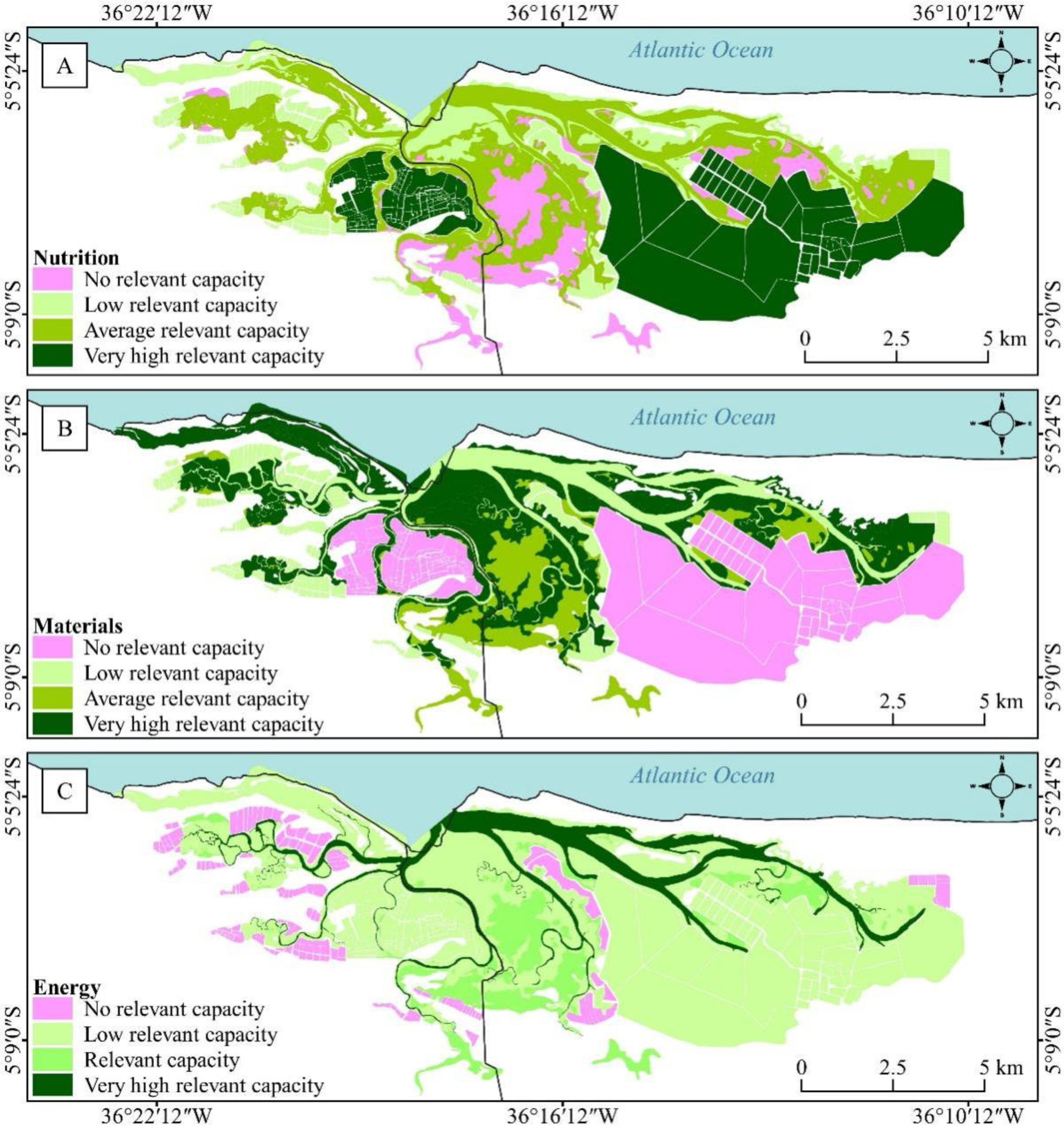
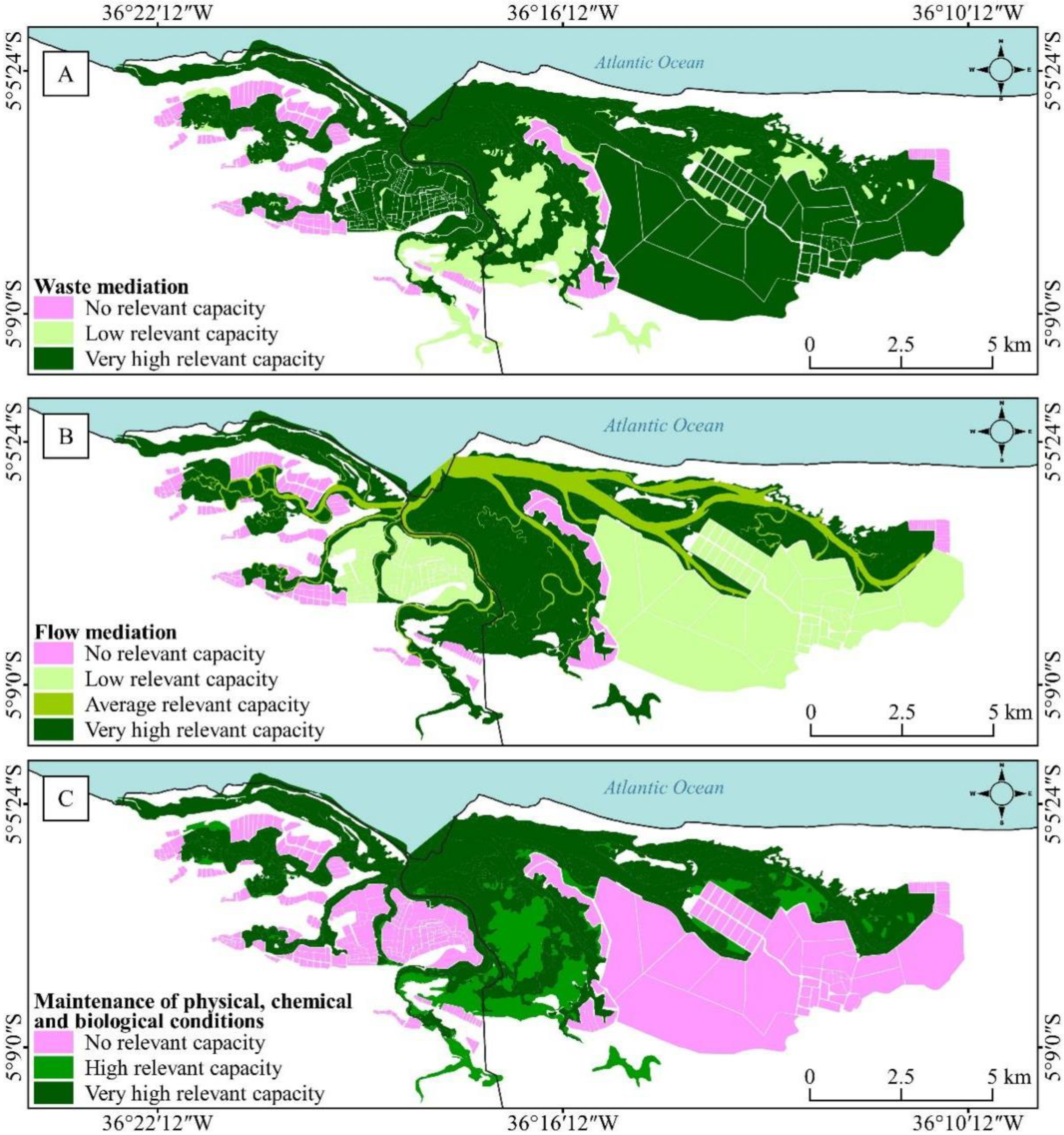
3.1. Identification of Ecosystem Services

According to the classification system of wetlands, the areas analyzed can be classified as marine and anthropogenic wetlands, where the former are subject to the impacts of predictable short-term tidal pulses (Table 1). Six macrohabitat types were identified: (1) natural macrohabitats: mangrove forest, apicum, estuary, and tidal flat; (2) anthropogenic macrohabitats: solar saltworks and shrimp ponds (Figure 1).
Table 1. The classification of wetland areas in the Galinhos-Guamaré estuarine system.
Systems SubsystemsSubclassesMacrohabitatsArea (km2)
Coastal
wetlands
Wetlands subject to the impacts of predictable short-duration tidal pulsesMarine
wetlands
Mangrove forest18.90
Tidal flat10.1
Estuary9.7
Apicum9.6
Anthropogenic
wetlands
--Solar saltworks31.0
Shrimp ponds 6.4
Source—Adapted [1].
Based on the adopted taxonomic system (Common International Classification of Ecosystem Services—CICES), ecosystem provision services including products and materials obtained from ecosystems were subdivided into ‘nutrition’, ‘materials’, and ‘energy’ (Table 2). In the ‘nutrition’ division, the biomass group is further divided into ‘animals, the use of animals for direct usage or transformation’ and ‘aquaculture animals’ classes. Thus, in the ‘animals and aquaculture animals’ class, the capture of crustaceans (crabs, soft-shell crabs, and shrimp) and mollusks, which are used for consumption in local communities, was identified in the mangrove forest and tidal plains. In the estuary, the practice of fishing for saltwater fish also exists, where shellfish and soft-shell crabs are also collected from its banks and tidal plains, with this being an important source of protein.
In terms of artificial ecosystems, shrimp ponds were one of the practices from the ‘aquaculture animals’ class with the farming of shrimp in captivity. In the nutrition division, the biomass group was included, as fishing in the initial evaporation ponds also takes place in the solar saltworks. This occurs because the ponds intake water from an estuary or directly from the sea, bringing fish and crustaceans in their juvenile phase, developing stable populations in these environments [4]. These populations represent a fish stock that is a source of animal protein and livelihood for many families in local communities [5]. The final sector (crystallization ponds) provides the formation of sea salt (halites) completely through natural processes involving physical (brine evaporation by solar radiation and winds as well as temperature maintenance during the night through argillaceous substrates) and biological (halobacteria that contribute to heating the brine above the natural level due to their dark reddish color) aspects from the environment [4]. Obtaining this product, which has been widely and historically used in human and animal nutrition, is also considered as an important nutritional ecosystem service [5].
In solar saltworks, the ‘use of animals for direct use, exploration, or transformation’ classification was based on the use of the microcrustacean Artemia sp. (Crustacea, Anostraca), which is manually harvested from saltworks and used to feed marine shrimp during their juvenile phase in shrimp ponds [5].
Specifically in areas with mangrove forests, the ESs from the ‘fibers/materials from plants and animals for direct use or transformation’ class were related to the use of wood extracted for the construction of temporary accommodation for fishermen as well as utensils used in fishing (e.g., oars, rods, etc.). The group ‘water’, also found in the materials division, highlighted the use of sea or estuary water for the operation of solar salt fields and shrimp ponds. To conclude the provision section, the ‘energy’ division was characterized by biomass-based energy sources (e.g., using wood material for combustion to cook food by fishermen and shellfish gatherers).
In the second section, regulation and maintenance services, Table 3, which shows the benefits obtained from natural processes that regulate environmental conditions, were divided into three divisions: waste mediation, flow mediation, and the maintenance of physical, chemical, and biological conditions.
The first ‘division’ was classified as ‘waste mediation’, where the ‘bioremediation’ class consisted of microorganisms and microalgae that perform biochemical detoxification, in which the micro-crustacean Artemia sp. (Crustacea, Anostraca) population from the solar salt fields stood out. The Artemia species acts as a brine biological filter and metabolizes large amounts of organic matter that could harm salt production, where its remains and feces are incorporated into benthic substrates, serving as food for the halobacterial populations of crystallizers [5].
Services provided by mangrove forests stood out in the ‘mass, liquid, and atmospheric flows’ group, easing the erosion of estuary margins and stabilizing the sediments suspended in water, when the regulation and maintenance services were subdivided into the ‘mass flow’ division [26]. The mangrove ecosystem also acts to minimize the intensive action of tides during potential floods or rains, serving as coastline protection and shelter for animals in the event of a storm.
The ‘flood protection’ class, which depends on the natural efficiency of the mangrove in protecting the coast against recurrent storms and other natural disasters, since this ecosystem can absorb a significant amount of water, reducing floods, and acting as a wind and wave barrier, was also mapped [34,35].
The ‘maintenance of physical, chemical, and biological conditions’ division, divided into the ‘maintenance of the life cycle and habitat’ and ‘pollination and seed dispersal’ groups, in which mangroves [33], and to a lesser extent solar salt fields [5], are a nursery and refuge for species. In these two ecosystems, the reproduction of species such as birds, crustaceans, and juvenile fish have been verified. In addition to being a habitat for migratory birds and many endemic species that use the mangrove, together with the decomposition of leaves, these help to enrich the substrate, also classifying these ecosystems in the ‘soil formation’ group. Finally, the climatic regulation that ecosystems provide helps reduce the concentration of greenhouse gases through carbon sequestration, and together with sea and land breezes alleviates the temperature and humidity, leaving the environment with greater balance and climatic stability.
For ESs in the cultural section (Table 4), which was associated with human values and behavior, the ‘intellectual and symbolic interactions’ and ‘physical and intellectual interactions with ecosystems’ divisions stood out. This was followed by the ‘existence value’ class, which was associated with feelings of well-being provided by the existence of plants and animals in ecosystems, for example, in addition to the ‘legacy’ class where the population thinks sustainably, so this may also take advantage of these resources.
In turn, the ‘physical and experiential interactions’ group used landscapes to elicit feelings of well-being in an individual, where there was an ‘admiration for the place’, while the group ‘intellectual and representative interactions’ was subdivided into five classes: scientific, educational, cultural heritage, entertainment, and aesthetic. From a scientific perspective, all wetland ecosystems are study targets, where these are the object of investigation by researchers, for example, in scientific articles, coursework, dissertations, and theses [19,36,37,38,39,40,41,42].
In the educational class, both the Galinhos and Guamaré municipalities are used by the state and higher education public and private education networks, so that students may know a reality different from their own, thus providing enriching experiences from the scientific, cultural, and social point of view. In terms of entertainment, this helps improve the physical and mental health by, for example, admiring the aesthetic landscape diversity and promoting ecotourism. In addition to the aesthetic, these landscapes are a source of inspiration for local culture, the production of canvases, paintings, poems, and photographs, among others [7]. Moreover, the wetlands become a scenario constituted of a set of ecosystems that form a cluster of rich scenic beauty with great interpretive potential.

3.2. Spatialization of Ecosystem Services

The wetlands identified in the Galinhos-Guamaré estuarine system were seen to provide various ESs for the provision, regulation and maintenance, and cultural categories, with results similar to those identified in the Piranhas-Açu estuarine complex [7], which is situated nearby on the same semiarid coast. In terms of the relevant capacity of each wetland to provide services, a matrix was created based on literature revisions, a checklist, and observations, with the estuary, mangrove forest, tidal flats, and solar saltworks being the most relevant in an overall analysis (Table 5). The wetland areas presenting the lowest performance were shrimp ponds, perhaps because their dynamics as an economic activity generally cause environmental pressures by their operation, involving the total emptying of shrimp fishing ponds [27].
The relevance of the provision of ESs from the provision, regulation and maintenance, and cultural sections is the result of linking macrohabitats with the ES rankings, according to Table 2, Table 3 and Table 4. From this, the ES provision capacities have been shown to vary between each division according to the wetland area. Thus, the categories established by CICES were individually applied for ES mapping and provided a basis for the analysis.
As for the ‘nutrition’ division from the provision services (Figure 3A), shrimp ponds and solar salt fields were observed to have a very high capacity for service provision, especially in the animals used for direct use or processing, aquaculture animals, and sea or river water classes. The mangrove forest and estuary presented an average relevant capacity. On the other hand, the tidal plains and apicum presented a low relevant capacity and no relevant capacity, respectively, to the nutrition division.
In the materials division (Figure 3B), mangrove forests and tidal flats showed very high relevant capacity, followed by the apicum, with an average relevant capacity. Estuary and shrimp ponds were spatialized as low relevant capacity, whereas solar salt fields showed no relevant capacity. Regarding the ‘energy’ division (Figure 3C), the estuary had a very high relevant capacity and apicum relevant capacity. The wetlands mangrove forest, tidal plain, and solar saltworks presented a low relevant capacity. However, shrimp ponds were classified with no relevant capacity.
In terms of the waste mediation division (Figure 4A) of the regulation and maintenance section, almost all wetlands presented a very high relevant capacity including mangrove forests, tidal flats, estuaries, and solar salt fields. The apicum provided a low relevant capacity, and the shrimp ponds presented no relevant capacity.
Mangrove forests and tidal flats and apicum obtained a very high relevant capacity for ES provision in the flow mediation division (Figure 4B) from the identified ESs. Estuaries presented average relevant capacities of great importance for the Galinhos-Guamaré estuarine system. However, solar salt fields obtained a low relevant capacity, whereby they protected the coastal zone from flooding and were sources of natural ventilation. With only one service provided (hydrological cycle and water flow maintenance), shrimp ponds were shown to be a wetland with no relevant capacity compared to other wetlands.
Regarding the ‘maintenance of physical, chemical, and biological conditions’ division (Figure 4C), the wetlands comprising the estuary, mangrove forest, and tidal plain had very high relevant capacity. The apicum was considered to have a high relevant capacity as it provides services that are important to maintain the environmental conditions of the studied area. However, solar salt fields and shrimp ponds were classified into no relevant capacity, with three and two ESs identified, respectively.
When it comes to cultural ecosystem services, area mapping showed the importance that wetlands represent for communities that comprise the Galinhos-Guamaré estuarine system. In addition, the estuary, mangrove forest, and solar salt fields presented a very high relevant capacity in the ‘intellectual and symbolic interactions with the ecosystem’ division (Figure 5A), characterized by having a symbolic, sacred character, a feeling of existence and legacy by families.
Tidal plains represented an area with high relevant capacity for the provision of cultural services. However, apicum and tidal flats presented an average relevant capacity, while shrimp ponds were defined as no relevant capacity areas, even with representation for local communities, as two cultural services were identified as symbolic and existence. Furthermore, the history of the state of Rio Grande do Norte is inherent with that of marine shrimps, being a local name given to those born in the state (shrimp eater). Therefore, the activity of shrimp farms is a cultural ecosystem service.
In terms of the ‘physical and intellectual interactions with the ecosystem’ division (Figure 5B), practically all wetlands in the Galinhos-Guamaré system had a very high relevant capacity, except for shrimp ponds, which had a no relevant capacity, even listing four ESs: scientific, educational, entertainment, and aesthetic.

4. Limitations of the Work

The authors state that this research was mainly carried out using GIS mapping of ecosystem services. There is a need for more detail about the alternative consequences of the same area/habitat uses. Trade-offs in human uses may be further studied and understood for a better application of the results of this research on coastal management.

5. Conclusions

From this study, the ES capacities were seen to vary among the macrohabitats of the Galinhos-Guamaré estuarine system, which allowed for the identification of potential ES provision areas and those of great importance for the provision, regulation and maintenance, and cultural services on a local scale. In terms of the capacity and relevance of the services provided by each macrohabitat, the elaborated matrix showed that estuary, mangrove forests, and estuary and tidal flats provided the most relevant services, and shrimp ponds presented the lowest performance. These results for the Brazilian semiarid coast confirm the studies of others and can contribute to national coastal planning.
With many of these services, both natural and anthropogenic macrohabitats present different capacities to provide ESs, often varying significantly among macrohabitats. However, it is noteworthy that these habitats are associated with ecosystems with great ecological, socio-economic, and cultural importance, whereas the general approach presented here requires more detailed research on each macrohabitat such as the investigation of quantitative and statistical data.

Author Contributions

D.F.d.S.C. designed the project and proposed the methodology; L.d.S.P. supervised A.C.D.S., D.R.d.C.G. and D.M.N. Investigation and Formal analysis; A.C.D.S. and A.M.d.O. carried out the analysis of satellite images and LULC changes. All authors have read and agreed to the published version of the manuscript.

Funding

National Institute of Science and Technology in Wetlands (INAU) (MCTI/CNPq/CAPES/FAPs—Proc.465436/2014-5/2017-2023); PROPESQ/UFRN (PVF16910-2019; PVF17310-2020), the CNPq (MCTI/CNPQ/Universal Proc.447227/2014-9); A.C.D.S. thanks Coordenação de Aperfeiçoamento de Pessoal de Nível Superior–Brasil (CAPES)–Finance Code 001; D.M.N. thanks the CAPES/INAU agreement for granting a post-doctoral research scholarship; L.d.S.P. thanks to CNPq for the Research Productivity Fellowship (Proc. 316941/2021—L.d.S.P.), CAPES for the Visiting Professor Fellow (Finance Code 001, L.d.S.P.) and PELD Semiarid Coast.

Acknowledgments

We thank the Laboratory & Research Group of Tropical Ecosystems Biogeography (TRÓPIKOS), and the Seridó Higher Education Center (CERES) of the Federal University of Rio Grande do Norte (UFRN), for their support with field and office work as well as Our thanks go to David Hélio Miranda de Medeiros (apicum and salt ponds), Renato de Medeiros Rocha (salt ponds and shrimp ponds), and Rogério Taygra Fernandes (salt ponds, mangroves and shrimp ponds) for their significant contributions as consulted experts. The authors are grateful to Bindy Datson for reviewing the manuscript writing in English and also thank the journal’s anonymous reviewers for their valuable contributions to the final version of the manuscript.

Conflicts of Interest

The authors declare no conflict of interest.

References

  1. Junk, W.J.; Piedade, M.T.F.; Lourival, R.; Wittmann, F.; Kandus, P.; Lacerda, L.D.; Bozelli, R.L.; Esteves, F.A.; Nunes da Cunha, C.; Maltchik, L.; et al. Brazilian wetlands: Their definition, delineation, and classification for research, sustainable management, and protection. Aquat. Conserv. Mar. Freshw. Ecosyst. 2014, 24, 5–22. [Google Scholar] [CrossRef]
  2. Junk, W.J.; Piedade, M.T.F.; Lourival, R.; Wittmann, F.; Kandus, P.; Lacerda, L.D.; Bozelli, R.L.; Esteves, F.A.; Nunes da Cunha, C.; Maltchik, L.; et al. Definição e Classificação das Áreas Úmidas (AUs) Brasileiras: Base Científica para uma Nova Política de Proteção e Manejo Sustentável. In Classificação e Delineamento das Áreas Úmidas Brasileiras e de seus Macrohabitats; Nunes da Cunha, C., Piedade, M.T.F., Junk, W.J., Eds.; EdUFMT: Cuiabá, Brazil, 2015; pp. 13–82. [Google Scholar]
  3. Diegues, A.C.S. An Inventory of Brazilian Wetlands, 15th ed.; IUCN: Gland, Switzerland, 1994. [Google Scholar]
  4. Costa, D.F.S. Caracterização Ecológica e Serviços Ambientais Prestados por Salinas Tropicais. Ph.D. Thesis, Departamento de Biologia, Universidade de Aveiro, Aveiro, Portugal, 2013. [Google Scholar]
  5. Costa, D.F.S.; Rocha, R.M.; Lillebo, A.; Soares, A.M.V.M. Análise dos serviços ambientais prestados pelas salinas solares. Boletim Gaúcho Geogr. 2014, 41, 195–209. [Google Scholar]
  6. Costa, D.F.S. Solar saltworks ecosystems an initial step for your valuation by ecosystems services in Brazil. SIL News 2015, 67, 9–10. [Google Scholar]
  7. Saldanha, D.S.; Costa, D.F.S. Classificação dos serviços ecossistêmicos prestados pelas áreas úmidas na zona estuarina do Rio Piancó-Piranhas-Açu (Nordeste, Brasil). Ateliê Geogr. 2019, 13, 263–282. [Google Scholar] [CrossRef]
  8. Haines-Young, R.H.; Potschin, M.B. Common International Classification of Ecosystem Services (CICES); Consultation on Version 4. European Environment Agency/Fabis Consulting Ltd.: Nottingham, UK, 2011; Available online: http://unstats.un.org/unsd/envaccounting/seeaLES/egm/Issue8a.pdf (accessed on 5 July 2017).
  9. Silva, D.E.M.; Costa, D.F.S. Classificação das áreas úmidas (AUs) hipersalinas da bacia hidrográfica do Rio Piancó-Piranhas-Açu e da Faixa Litorânea Norte de Escoamento Difuso. Rev. Geoci. Nordeste 2016, 2, 1436–1446. [Google Scholar] [CrossRef]
  10. Costa, D.F.S.; Guedes, D.R.C.; Silva, D.E.M. Identificação dos padrões morfométricos dos sistemas lacustres e flúvio-lagunares no litoral setentrional do Rio Grande do Norte. Bol. Paul. Geogr. 2016, 94, 65–83. [Google Scholar]
  11. Costa Neto, L.X. Caracterização Geológica, Geomorfológica e Oceanográfica do Sistema Pisa Sal, Galinhos/RN—Nordeste do Brasil, Com Ênfase à Erosão, ao Transporte e à Sedimentação; Tese em Geodinâmica e Geofísica (Programa de Pós-graduação em Geodinâmica e Geofísica)—Centro de Ciências Exatas e da Terra, Universidade Federal do Rio Grande do Norte: Natal, Brazil, 2009. [Google Scholar]
  12. Diniz, M.T.M.; Pereira, V.H.C. Climatologia do estado do Rio Grande do Norte, Brasil: Sistemas atmosféricos atuantes e mapeamento de tipos de clima. Bol. Goia. Geogr. 2015, 35, 488–506. [Google Scholar]
  13. Ximenes, A.C.; Maeda, E.E.; Arcoverde, G.F.B.; Dahdouh-Guebas, F. Spatial assessment of the bioclimatic and environmental factors driving mangrove tree species’ distribution along the Brazilian Coastline. Remote Sens. 2016, 8, 451. [Google Scholar] [CrossRef]
  14. Tomlinson, P.B. The Botany of Mangroves; Cambridge University Press: Cambridge, UK, 1986; pp. 1–413. [Google Scholar]
  15. Costa, D.F.S.; De Medeiros Rocha, R.; Cestaro, L.A. Análise fitoecológica e zonação do manguezal em um estuário hipersalino. Mercator 2014, 13, 119–126. [Google Scholar] [CrossRef]
  16. Alle-Levinson, A.; Schettini, C.A.F. Fortnightly switching of residual flow drivers in a tropical semiarid estuary. Estuar. Coast. Shelf Sci. 2016, 169, 46–55. [Google Scholar] [CrossRef]
  17. Morais, J.O.; Pinheiro, L.S. The effect of semi-aridity and damming on sedimentary dynamics in estuaries-Northeastern region of Brazil. J. Coast. Res. 2011, 64, 1540–1544. [Google Scholar]
  18. Soares, M.O.; Campos, C.C.; Carneiro, P.B.M.; Barroso, H.S.; Marins, R.V.; Teixeira, C.E.P.; Menezes, M.O.B.; Pinheiro, L.S.; Viana, M.B.; Feitosa, C.V.; et al. Challenges and perspectives for the Brazilian semi-arid coast under global environmental changes. Perspect. Ecol. Conserv. 2021, 1, 1–20. [Google Scholar] [CrossRef]
  19. Pinheiro, L.S.; Limongi, C.M.; Morais, J.O. Erosive processes monitoring linked to the estuarine evolution systems nearby Aguas Belas, Cascavel, Ceará, Brazil. J. Coast. Res. 2006, 39, 1403–1406. [Google Scholar]
  20. Schettini, C.A.F.; Valle-Levinson, A.; Truccolo, E.C. Circulation and transport in short, low-inflow estuaries under anthropogenic stresses. Reg. Stud. Mar. Sci. 2017, 10, 52–64. [Google Scholar] [CrossRef]
  21. Miranda, L.B.; Castro, B.M.; Kjerfve, B. Princípios de Oceanografia Física de Estuários; Editora da Universidade de São Paulo: São Paulo, Brazil, 2002. [Google Scholar]
  22. Costa, D.F.S.; Silva, D.E.M.; Souza, A.C.D.; Saldanha, D.S.; Lillebø, A.I. Precipitação geoquímica em ambientes evaporíticos/Hipersalinos: O caso das salinas solares do Brasil. Rev. Geoci. Nordeste 2018, 4, 58–70. [Google Scholar] [CrossRef]
  23. Santos, C.S.; Araújo, M.V.P.; Almeida, S.T. A carcinicultura no Rio Grande do Norte: Perspectivas e desafios. Rev. Gestão Unilasalle 2015, 4, 131–153. [Google Scholar] [CrossRef] [Green Version]
  24. Tahim, E.F.; Araújo Junior, I.F. A carcinicultura do nordeste brasileiro e sua inserção em cadeias globais de produção: Foco nos APLs do Ceará. Rev. Econ. Soc. Rural 2014, 52, 567–586. [Google Scholar] [CrossRef]
  25. Tavares, M.A.A. O Uso do Território Pelos Circuitos Espaciais de Produção da Indústria no Rio Grande do Norte. Ph.D. Thesis, Faculdade de Filosofia, Letras e Ciências Humanas, Universidade de São Paulo, São Paulo, Brazil, 2017. [Google Scholar]
  26. Vanucci, M. Os Manguezais e Nós: Uma Síntese de Percepções, 2nd ed.; Editora da Universidade de São Paulo: São Paulo, Brazil, 2002. [Google Scholar]
  27. Lacerda, L.D.; Ward, R.D.; Godoy, M.D.P.; Meireles, A.J.A.; Borges, R.; Ferreira, A.C. 20-years cumulative impact from shrimp farming on mangroves of Northeast Brazil. Front. For. Glob. Chang. Trop. For. 2021, 4, 1–17. [Google Scholar] [CrossRef]
  28. Scott, D.A.; Jones, T.A. Classification and inventory of wetlands: A global overview. Vegetatio 1995, 118, 3–16. [Google Scholar] [CrossRef]
  29. Maes, J.; Crossman, N.D.; Burkhard, B. Mapping ecosystem services. In Routledge Handbook of Ecosystem Services; Potschin, M., Haines-Young, R., Fish, R., Turner, R.K., Eds.; Routlegde: London, UK, 2016; pp. 188–204. [Google Scholar]
  30. Burkhard, B.; Maes, J. Mapping Ecosystem Services; Pensoft Publishers: Sofia, Bulgaria, 2017. [Google Scholar]
  31. QGIS Development Team. QGIS Geographic Information System. 2020. Available online: https://www.qgis.org/pt_BR/site/forusers/download.html (accessed on 10 March 2021).
  32. Burkhard, B. Ecosystem services matrix. In Mapping Ecosystem Services; Burkhard, B., Maes, J., Eds.; Pensoft Publishers: Sofia, Bulgaria, 2017; pp. 227–232. [Google Scholar]
  33. Jacobs, S.; Burkhard, B. Applying expert knowledge for ecosystem services quantification. In Mapping Ecosystem Services; Burkhard, B., Maes, J., Eds.; Pensoft Publishers: Sofia, Bulgaria, 2017; pp. 144–148. [Google Scholar]
  34. Mukherjee, N.; Sutherland, W.J.; Dicks, L.; Hugé, J.; Koedam, N.; Dahdouh-Guebas, F. Ecosystem service valuations of mangrove ecosystems to inform decision making and future valuation exercises. PLoS ONE 2014, 9, 1–9. [Google Scholar] [CrossRef]
  35. Menéndez, P.; Losada, I.J.; Torres-Ortega, S.; Narayan, S.; Beck, M.W. The Global Flood Protection Benefits of Mangroves. Sci Rep. 2020, 10, 4404. [Google Scholar] [CrossRef] [PubMed]
  36. Lima, Z.M.C. Caracterização da Dinâmica Ambiental da Região Costeira do Município de Galinhos, Litoral Setentrional do Rio Grande do Norte. Ph.D. Thesis, Centro de Ciências Exatas e da Terra, Universidade Federal do Rio Grande do Norte, Natal, Brazil, 2004. [Google Scholar]
  37. Ferreira, A.L.; Vital, H.; Stattegger, K.; Caldas, L.H.O.; Gomes, M.P.; Perez, Y.A.R.; Silva, A.G.A. Seismic architecture of the tidal channel system of Galinhos, equatorial Atlantic, Brazil. Mar. Geol. 2022, 443, 106685. [Google Scholar] [CrossRef]
  38. Silva, F.E.; Vital, H. Quantifying the high coastal dynamics of tropical mesotidal barrier island-spit systems: Case study in Northeast Brazil. Geo-Mar. Lett. 2020, 40, 897–909. [Google Scholar] [CrossRef]
  39. Silva, C.J.A.; Viola, G.G.; Bertini, L.M. Desvendando a relevância do ecossistema manguezal através de uma unidade didática. Rev. Elet. Cient. Ens. Int. 2019, 14, 374–387. [Google Scholar] [CrossRef]
  40. Diniz, M.T.M.; Ferreira, A.S.; Maria, G.K.M. Análise integrada da paisagem e formas de uso do solo no litoral de Galinhos/RN: Subsídios à gestão integrada da zona costeira. Cad. Geogr. 2015, 25, 49–69. [Google Scholar] [CrossRef]
  41. Marcelino, A.M.T.; Pinheiro, L.R.S.G.; Costa, J.R.S. Planejamento participativo para a gestão da orla marítima de Galinhos/RN, nordeste brasileiro, com apoio de sensores remotos e modelagem costeira. Desenvolv. Meio Ambiente 2018, 44, 118–139. [Google Scholar] [CrossRef] [Green Version]
  42. Rocha, D.F. Análise da Vulnerabilidade Ambiental do Município de Galinhos, RN, Brasil. Ph.D. Thesis, Centro de Biociências, Universidade Federal do Rio Grande do Norte, Natal, Brazil, 2019. [Google Scholar]
Figure 1. The land use and cover change in the Galinhos-Guamaré estuarine system.
Coasts 02 00012 g001
Figure 3. Spatialization of the relevant capacity of the provision section by macrohabitat from the Galinhos-Guamaré estuarine system ((A)—Nutrition E.S.; (B)—Material E.S.; (C)—Energy E.S.)
Coasts 02 00012 g003
Figure 4. Spatialization of the relevant capacity of the regulation and maintenance section by macrohabitats from the Galinhos-Guamaré estuarine system. ((A)—Waste mediation E.S.; (B)—Flow mediation E.S.; (C)—Physical, chemical and biological maintenance E.S.).
Coasts 02 00012 g004
Figure 5. Spatialization of the relevant capacity of the cultural section by macrohabitat from the Galinhos-Guamaré estuarine system ((A)—Intellectual and symbolic interactions with the ecosystem’ E.S.; (B)—Physical and intellectual interactions with the ecosystem E.S.).
Coasts 02 00012 g005
Table 2. The ES classification of the provision section, Galinhos-Guamaré estuarine system.
SectionDivisionGroupClassApic.S. PondsEstu.Man. FT. Fl.Sol. Sal.
ProvisionNutritionBiomassAnimals ××××
Use of animals for direct use or processing ××× ×
Aquaculture animals × ×
WaterSea or estuarine water× ××××
MaterialsBiomassFibers/materials from plants and animals for direct or transformation uses ××××××
Materials, plants and animals for agricultural uses × ××
WaterNon-potable sea or
estuarine water
× ×××
Non-potable subterranean
water
× ××
EnergyBiomass-based energy sourcesPlant-based resources× ××
Animal-based resources ×
Mechanical energyEnergy from biotic and abiotic factors × ××××
Legend: Apic—apicum; S. Ponds—shrimp ponds; Estu—estuary; Mang. F—Mangrove forest; T. Fl—tidal flat; Sol. Sal.—solar saltworks; ×—presence of ES.
Table 3. The classification of ESs for the regulation and maintenance of the Galinhos-Guamaré estuarine system.
SectionDivisionGroupClassApic.S. PondsEstu.Man. F.T. Fl.Sol. Sal.
Regulation and maintenanceWaste mediationBiota mediationBioremediation by microorganisms, plants, algae, and animals × ××××
Filtration, sequestration ×××××
Ecosystem mediationFiltration, sequestration××××××
Dilution by water,
fresh water, and
marine ecosystems
× ××××
Mediation of scents, noise, and visual impacts ××××
Flow mediationMass flowsMass stabilization and
erosion rate control
× ××
Attenuation of mass flows× ××
Liquid flows Hydrological cycle and water flow maintenance× ××××
Flood protection× ××××
Atmospheric flowsStorm protection× ×××
Ventilation and
perspiration
× ××××
Maintenance of physical, chemical, and biological conditionsMaintenance of the life cycle, habitat, and gene bank protectionPollination and seed
dispersal
× ×××
Maintenance of nurseries and habitats ×××
Pest and disease controlPest control× ×××
Disease control× ×××
Soil formationWeathering process× ×××
Fixation decomposition process××××××
Water conditionFreshwater chemical
condition
× ×××
Saltwater chemical
condition
× ××××
Atmosphere composition and climate regulationGlobal climate regulation to reduce the concentration of greenhouse gases ××××××
Micro and macro-regional
climate regulation
×××
Legend: Apic—apicum; S. Ponds—shrimp ponds; Estu—estuary; Mang. F—mangrove forest; T. Fl—tidal flat; Sol. Sal.—solar saltworks; ×—the presence of ES.
Table 4. The classification of cultural ESs from the Galinhos-Guamaré estuarine system.
SectionDivisionGroupClassApic.S. PondsEstu.Man. F.T. Fl.Sol. Sal.
CulturalIntellectual and symbolic interactions with the ecosystemSpiritual or emblematicSymbolic× ××× ××
Sacred or religious ×× ×
OthersExistence× ×××××
Legacy× ××××
Physical and intellectual interactions with the ecosystemPhysical and experiential interactionsUse of plants, animals, and landscapes× ××××
Intellectual and representative interactionsScientific××××××
Educational××××××
Cultural heritage× ××××
Entertainment××××××
Aesthetic××××××
Legend: Apic—apicum; S. Ponds—shrimp ponds; Estu—estuary; Mang. F—mangrove forest; T. Fl—tidal flat; Sol. Sal.—solar saltworks; ×—presence of ES.
Table 5. The ES matrix of the Galinhos-Guamaré estuarine system.
Ʃ ProvisionNutritionMaterialsEnergyƩ Regulation and
Maintenance
Waste MediationFlow MediationMaintenance of Physical, Chemical, and Biological ConditionsƩ CulturalIntellectual and Symbolic Interactions with the EcosystemPhysical and Intellectual Interactions with the Ecosystem
Apicum503210154835
Shrimp ponds65100000110
Estuary9315135351055
Mangrove forest 9351155551055
Tidal flat 715115555835
Solar saltworks 650165101055
Publisher’s Note: MDPI stays neutral with regard to jurisdictional claims in published maps and institutional affiliations.

